Agricultural Transformation in Maningamuwa, a Village in ...
28
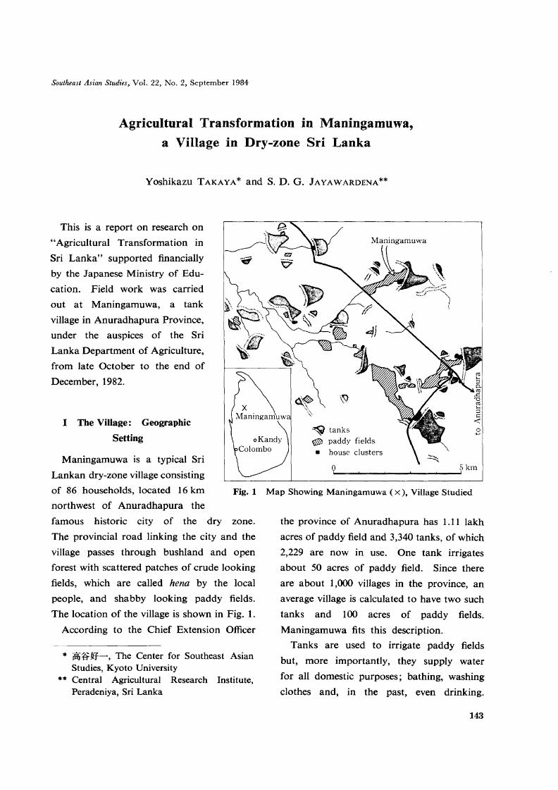
Southeast Asian Studies, Vol. 22, No.2, September 1984 Agricultural Transformation in Maningamuwa, a Village in Dry-zone Sri Lanka Yoshikazu TAKAYA* and S. D. G. JAYAWARDENA** This is a report on research on "Agricultural Transformation in Sri Lanka" supported financially by the Japanese Ministry of Edu- cation. Field work was carried out at Maningamuwa, a tank village in Anuradhapura Province, under the auspices of the Sri Lanka Department of Agriculture, from late October to the end of December, 1982. I The Village: Geographic Setting Maningamuwa is a typical Sri Lankan dry-zone village consisting of 86 households, located 16 km Fig. 1 northwest of Anuradhapura the famous historic city of the dry zone. The provincial road linking the city and the village passes through bushland and open forest with scattered patches of crude looking fields, which are called hena by the local people, and shabby looking paddy fields. The location of the village is shown in Fig. 1. According to the Chief Extension Officer * iWi:frW-, The Center for Southeast Asian Studies, Kyoto University ** Central Agricultural Research Institute, Peradeniya, Sri Lanka tanks paddy fields • house clusters n 5km Yb • Map Showing Maningamuwa (x), Village Studied the province of Anuradhapura has 1.11 lakh acres of paddy field and 3,340 tanks, of which 2,229 are now in use. One tank irrigates about 50 acres of paddy field. Since there are about 1,000 villages in the province, an average village is calculated to have two such tanks and 100 acres of paddy fields. Maningamuwa fits this description. Tanks are used to irrigate paddy fields but, more importantly, they supply water for all domestic purposes; bathing, washing clothes and, in the past, even drinking. 143
Transcript of Agricultural Transformation in Maningamuwa, a Village in ...
Southeast Asian Studies, Vol. 22, No.2, September 1984
Agricultural Transformation in Maningamuwa,
a Village in Dry-zone Sri Lanka
Yoshikazu TAKAYA* and S. D. G. JAYAWARDENA**
This is a report on research on
"Agricultural Transformation in
Sri Lanka" supported financially
by the Japanese Ministry of Edu
cation. Field work was carried
out at Maningamuwa, a tank
village in Anuradhapura Province,
under the auspices of the Sri
Lanka Department of Agriculture,
from late October to the end of
December, 1982.
I The Village: Geographic
Setting
Maningamuwa is a typical Sri
Lankan dry-zone village consisting
of 86 households, located 16 km Fig. 1
northwest of Anuradhapura the
famous historic city of the dry zone.
The provincial road linking the city and the
village passes through bushland and open
forest with scattered patches of crude looking
fields, which are called hena by the local
people, and shabby looking paddy fields.
The location of the village is shown in Fig. 1.
According to the Chief Extension Officer
* iWi:frW-, The Center for Southeast AsianStudies, Kyoto University
** Central Agricultural Research Institute,Peradeniya, Sri Lanka
.~ tanks~ paddy fields
• house clusters
n 5kmYb• ====!.==",===='==~===:J!
Map Showing Maningamuwa (x), Village Studied
the province of Anuradhapura has 1.11 lakh
acres of paddy field and 3,340 tanks, of which
2,229 are now in use. One tank irrigates
about 50 acres of paddy field. Since there
are about 1,000 villages in the province, an
average village is calculated to have two such
tanks and 100 acres of paddy fields.
Maningamuwa fits this description.
Tanks are used to irrigate paddy fields
but, more importantly, they supply water
for all domestic purposes; bathing, washing
clothes and, in the past, even drinking.
143

Tank water is indispensable for buffaloes
and cattle too. Tanks are constructed by
building an earthen dam, usually 2 to 4 m
high and a half to one mile long, across a
shallow valley. There are larger tanks but
these are government-maintained and distinct
from the so-called village tanks with which
this paper deals.
Villages usually consist of a cluster of 10
to 20 houses close to the tank plus indi
vidual houses along village tracks. In
Maningamuwa there are many such houses
along the track linking the pl'ovincial road
with the cluster of houses beside the tank.
Each homestead in the cluster consists of
a building for living in (occasionally two),
a small open space for drying par-boiled rice,
and a few garden trees, and is surrounded
by a simple hedge. Most houses still follow
the traditional pattern, particularly in this
part of Anuradhapura Province. Three thick
earthen walls called warrichi form two or
()
village track
o
o
o
a. chamber for family 6
b. chamber for family 6"
c. kitchen for the 6 & 6"
d. veranda
e. chamber for family 6'
f. veranda
g. kitchen for the 6'
h. former rice storage site
I. open space
j. well
Fig.2 An Example of Homestead. In this case families Nos. 6, 6' & 6// live in the same homestead.Refer to Fig. 9 also.
144

Y. TAKAYA and S. D. G. ]AYAWARDENA: Agricultural Transformation in Dry-zone Sri Lanka
three rooms as shown in Fig. 2, with a
thatched roof of straw. The rooms are as
small as 3 m 2 and open onto the front yard.
The veranda is about 1 m wide, and is where
visitors sit, talk, and sometimes pass the
night. If a building has three rooms it is
often shared by three families. Boys often
have to sleep on the veranda to save room
for other family members. These houses
always have an additional small warrichi
room, either attached or separate. This is
the kitchen which is often shared by two or
occasionally three families living in the
same building. A well is commonly found
in each homestead.
In Maningamuwa the isolated houses were
all built quite recently and stand in the midst
of fields planted to maize, cowpeas, etc., or
occasionally surrounded by wild brush wood.
The principal pattern of these houses is the
same as those found in the cluster, but their
finish is much cruder. Some new houses
have tiled rooves.
II Paddy Growing
Paddy fields are all, directly or indirectly,
tank irrigated. Hena (fields in forest or
bushland) are rainfed.
II-i Three Kinds of Paddy Fields
Maningamuwa has three kinds of paddy
fields; puranawela, akkarawela and aswaddum.
Puranawela are the oldest type and no
one knows when they were constructed.
They are elongated plots parallel to the
tank bank and just below it. By definition
these fields enjoy the sole rights to the tank
water.
Akkarawela is translated "new paddy
fields". The oldest in Maningamuwa is
assumed to have been opened sometime in
the 1930s, and many others are about 30
years old. Akkarawela fields are located
either downstream of, or on the slopes beside,
puranawela. Some akkarawela fields have
the right to use tank water, but others do
not. Legally speaking, what the people
of Maningamuwa call akkarawela included
sinnakkarawela (real akkarawela), privately
owned paddy fields and badu idam or those
with a lease title.
Fields called aswaddum are unregistered
paddy fields. These are more recently
reclaimed and more marginally located.
The distribution of these three kinds of paddy
fields is shown in Fig. 3.
Paddy fields in Maningamuwa are divided
into parcels called kotuwas. As we can see
from Fig. 3, there are 18 kotuwas in
Maningamuwa, each of which has its own
name. The kotuwa is the working unit for
irrigation and fencing. The names of the
18 kotuwas are:
Is; Maha akkara kotuwa
2s; ?3s; ?4t; Siyabala gaha k.
5t; Kudawewa godahorowwa akkara k.
6t; Wewalagaha akkara k.
7t; do
8t; do
9s; Gamsooriya gaha k.
lOs; Dahaye kanuwa millagaha k.
lIs; ?
12t; Puranawelapahala akkara k.
13t; Siyabala gaha k. (2)
14t; Siyabala gaha k. (3)
145

---------- -. --------<to
0.5 mile C6===============:1' ~o
PI, P2; puranawela, Is-18s; akkarawela, 19r-21r; aswaddum, M; madahorowwa,G; godahorowwa, A-D; small dams, CI; house cluster, -----+; canals, 0; houses
Fig. 3 Distribution of Paddy Fields with relation to the Village Tank, Canals and Streams
15s; Athapattu k.
16t; Serisena k.
17s; Siyabala gaha k.
18s; Dahaye kanuwa k.
II-ii Growing Methods
All the important decisions related to
paddy cultivation in puranawela and akka
rawela are decided at a village meeting
(kanna) composed of all the farmers and pre
sided by welvidane, the irrigation chief of the
village. The 1982 meeting, which was held
on November 16th, decided the following.
a) The date of the first issue of tank water
would be December 16th.
b) Every man must clean the irrigation
canals which pass through his field
by December 15th.
c) Land preparation had to be done
between December 16th and December
24th.
d) The kotuwa fence must be erected by
December 25th.
e) Sowing was to be done between
December 25th and January 1st, using
seed of 4 to 4 I/2-month varieties,
preferably BG 11-11.
Until five or six years ago the buffalo-drawn
plow was the principal tillage method, but
now the tractor is more popular. Fields
are plowed twice and then levelled with a hand
leveller. At this time the farmers trample
weeds into the soil. Then drainage channels
about 20 cm wide and 6 to 7 cm deep are cut
into the levelled surface using a hoe. These
allow excess water to drain as quickly as
possible so that there is no standing water in
the field at the time of sowing.
Germinated seed is almost always broadcast
on well prepared fields. The farmers prefer
4 to 4 1/2-month varieties; they say that
quick-growing varieties give poor yields.
146

Y. TAKAYA and S. D. G.JAYAWARDENA: Agricultural Transformation in Dry-zone Sri Lanka
Some farmers told us that three-month
varieties are only economic on hena land.
Everyone buys seed paddy from the coop
erative, they never store it at home. After
sowing at least one or two people stay in the
field to scare away the parrots which come
in hundreds and perch on fence awaiting a
chance to steal the seed.
The fields are not weeded. In fact, because
this is the busiest season in the hena fields, the
people do not even stay in the village, only
returning when harvest time approaches.
The rice is reaped with sickles and piled, in
bundles, on a small mound (about 1.5 m 2)
in each field for twq or three days.
Meanwhile large threshing grounds are built
here and there in the fields by groups of
three or four families. Paddy is threshed
by buffalo-trampling, winnowed, and then
taken home and stored in gunny sacks.
II-iii Fencing and Guarding
The fields must be protected against wild
boar, monkeys, deer, elephants, buffaloes,
and cattle with strong fences during the
growing season.
Kotuwa is treated as one unit. Each farmer
whose fields border the forest, bushland or
a track must build a fence along these borders.
Thus the entire kotuwa is surrounded by a
continuous fence. The work is done in
dividually, using whatever materials are
available. Some farmers use barbed-wire
but many use sticks and poles collected from
the forest. Then watch huts are built.
These are usually built on stilts about 1.5 m
off the ground and have a floor space of
about 3 m 2• It is said that in the past some
huts were built in large trees to provide a
place to escape to if elephants attacked.
Watch huts are built every year at fixed sites
by the joint efforts of the farmers concerned.
The puranawela has seven watch huts, kotuwa
4t two, kotuwa Is three, kotuwa lIs one,
kotuwas 9s and lOs two, kotuwa 17s one,
and so forth. The fencing and hut building
occur immediately before sowing.
When the paddy begins to ripen guard duty
begins. A guard schedule is prepared, with
day duty from 6 a.m. to 6 p.m. and night
duty from 6 p.m. to 6 a.m. The former is
usually done by women and children, while
night duty is men's work. It is said that an
average paddy-field owner has to spend about
five nights in the watch hut per season.
II-iv Irrigation
The size of the Maningamuwa tank is
about average for the area. Its embankment
is 3 m high and about 1 km long. It has
two sluice gates; the main one, called
madahorowwa or lower sluice gate, and the
other called godahorowwa or upper sluice
gate which was built later. The difference in
elevation between the two is 1 m.
In the past, there being no other paddy
fields, tank water was used solely to irrigate
the puranawela, but now this tank supplies
water to some other kotuwas as shown in
Fig. 3.
The puranawela is irrigated via two main
canals, the northern and the central ones from
the main sluice gate. The northern canal
irrigates the northern half of the puranawela,
and the central one the southern half.
Kotuwas 7t, 8t, 4t, 13t, and 14t are irrigated
by the southern canal, which was built
sometime in the 1930s primarily to supply
147

Dam; small earthen dam, Int; intake, Can; canal,Slu; sluice, Pf; paddy fields, d; farm dike, S;stream, b; stream bank, w; waste land
Fig.4 A Schematic Picture Showing the Make Up of theSmall Dams to Irrigate Akkarawela
water to kotuwa 4t, and kotuwas 5t, 6t and
16t are irrigated by the canal from the upper
sluice gate.
Kotuwa 12t gets the tail water of the
puranawela.
Other kotuwas cannot receive water from
the tank but have their own small pools
built across the stream. Kotuwas 1s, 2s, 3s,
and 15s are irrigated by canals carrying water
from pool A. Kotuwas 9s and lOs receive
water from pool B. Kotuwa 11s receives
water from pool C and kotuwas 17s and 18s
receive water from pool D.
The structure of the small pools mentioned
above is shown schematically in Fig. 4.
The stream is 6 or 7 m wide and an earthen
dam about a meter high and 30 to 40 m long
has been built across it. One corner of the
dam is kept open and serves as an intake for
last 10 years it had not done so
and he had kept the gate closed.
This meant that, in those years, no
fields could be planted, including
those irrigated by small pools, be
cause they are also fed by seepage
water from the tank.
canals below. There is no gate at this intake,
so water flow depends on the water level.
There is no open spillway to drain the water
but instead, a six-inch diameter earthenware
pipe is buried under the dam. The upstream
side of this pipe is connected to a vertical
pipe consisting of a series of cubes with con
necting cylindrical holes. As long as the
uppermost cube is above the water level,
water cannot pass through this pipe. When
people want to take water from the pool
they remove the cube(s) which are above
the water level and water then flows through
the pipe.
Since there is insufficient water to irrigate
all the fields water theft is common. People
with downstream fields illegally remove the
cube to get water to flow from the upper
pool to their pool. Clashes between
watchmen and water thieves are
said to be not uncommon. It is
the welvidane's duty to settle this
kind of dispute.
The welvidane's most important
job, besides presiding at the kanna
meeting, is to operate the sluice
gates of the village tank. Accord
ing to the welvidane, it is an
unwritten law that he opens the
gate only when the water level of
the tank has reached more than 6
ft. He said that in four of the
Int
Pf
w
o Smb:......I
I(
V 'If W\1
V
\r VY
148

Y. TAKAYA and S. D. G.jAYAWARDENA: Agricultural Transformation in Dry-zone Sri Lanka
The welvidane gets two bushels of paddy
per acre for the services he extends to the
village. He said that he cannot collect this
paddy, however, when paddy yields are low
or crops fail.
II-v Rituals
Some people stick a stick with a coconut
in the middle of newly prepared fields and pray
for a bumper harvest, but ceremonies at the
time of land preparation and sowing are
neither sophisticated nor popularly observed.
The most important ritual is at harvest
time. First a very small plot is harvested
and a bundle of the ears hung on a pole
in the field. The rest of the fields are then
harvested. When a threshing floor has been
made ready, a small hole, about 15 cm
across and 15 cm deep, is dug in the middle
of the floor and a piece of iron placed in it.
Any iron is all right, a piece of a broken
sickle or a nail, but it must be washed and
purified with coconut milk before being put
in the hole. Some people place a coconut
shell and/or some herbs, which are supposed
to have magical power, in the hole. The
hole is called harak (cattle) wala (hole).
When this is finished a man appears holding
another bundle of rice, a fork, a broom, and
a stick, all used for threshing, on his head,
and circles the harak wala solemnly three
times. He then puts the rice and tools in the
middle of the floor and threshes the rice by
rubbing it between his palms over the hole,
so that the grain falls into the hole. It is
strictly taboo to make any noise during this
ceremony.
The remaining rice can now be threshed
by buffalo trampling. When all the grain
has been threshed, the bundle which has
been hanging on the pole is carried to the
threshing ground and threshed, like the
ceremonial bundle, by rubbing between the
palms. This ends the threshing operation.
During the entire operation, not just the
ceremonies, women are forbidden to come
near the threshing ground. The last, cere
monially threshed, grain is taken home, mixed
with other grain, and cooked immediately
into milk rice. The first rice thus cooked
must be first offered to the guardian gods,
Bhuddha, and crows and other birds, and then
eaten by family members. This ceremony is
called aluth bath danaya (new rice offering).
Another ceremony is called kiri ithirum
(boiling milk till the pot overflows). The
timing varies from place to place, but it is
celebrated in May in Maningamuwa. On
this day people carry cooking pots, rice and
milk to the bank of the village tank and
cook milk rice. It is important to see the
milk rice bubbling vigorously, which is
supposed to be a good omen for a bumper
crop in the coming season. This festival
is very similar to the Tamil pongal festival.
III Upland Cultivation
III-i Hena Cultivation
The hena cropping season is slightly earlier
than that of wet paddy. The cropping
calendar adopted in Maningamuwa is shown
below.
Hena cultivation is practiced either in the
forest or on bushland. In the former such
trees as weera (Drypetes sepiaria), damha
(Syzygium assimile), palu (Manilkara
hexandra), kunumalla (Diospyros ovalifolia),
149

8 9 10 11 12 1 2 3 4 5 6 7 month
1· .. ············ .. ·1preparation
& sowing of rice
1· .. ··············1harvest of rice &sesamum sowing
1.. ···· .. 1harvest
ofsesamumhena
1.. ·.. ·.. ·· .. ·.... ·.. 1
preparation& sowing
1··· .. ·.. ·· .... ···1harvest lowland
Fig.5 The Cropping Calendar of Hena and Lowland in Maningamuwa
and maila (Bauhinia racemosa) are dominant,
while in the latter kuratiya (Memecylon
rostratum), andera (Dichrostachys cinerea),
maila, katupilla (Flueggea leucopyrus) and
ela nitulla (Plumbago zeylanica) dominate.
In August trees and bush are cut down and
left to dry. Burning occurs before nikini
(the eighth month) palu (destructive) wassa
(rain) begins. Often two or three families
work together, but not necessarily. The
firing starts on the windward side of the field,
no fire-break is cleared since the fire is said
to die out when it reaches the other side of
the cleared area. Next handy-sized sticks
and poles which have escaped the burning,
are collected and used to build a fence around
the cleared plot. About a week after the
first burning the field is fired again. This
time all remaining vegetation is piled in to
small heaps and set on fire.
Sometime in late September or early
October, when the rain has set in, fields
are prepared with mammoty (hoe) and sown.
Traditionally maize is sown first, and when
it is about a foot tall, or 15 to 20 days after
the sowing, seeds of kurakkan (finger millet),
mustard and chilli are broadcast among the
standing maize plants. Weeding is done with
a small hand hoe. About three months
after sowing the maize is ready to harvest.
150
Kurakkan is also a three-month crop, so it is
harvested 15 to 20 days after the maize.
The mustard and chilli ripen about 10 days
later. Upland rice is occasionally planted
in place of kurakkan or sometimes as a
separate crop.
The most serious problem with hena culti
vation is the hazard from wild animals.
Wild boar like young maize stalks very much
because they contain a sweet juice. One
wild boar can eat as many as 60 plants in one
night and they also attack cassava. Monkeys
are a problem when maize and rice ripen and
are very fond of chilli leaves also. Parrots
attack rice and beans when they are sown
and when ripe. The worst damage is,
however, done by elephants. If this animal
get into the field, crops are miserably crushed
and devoured at any time of the year.
After the harvest of the maha season crops,
stubble grazing is a popular practice, but a
certain portion of the land is prepared for
sesamum. Young shoots and weeds which
have grown in the maha season are cut together
with maize and kurakkan stubble and burned.
Sesamum seed is sown in February or
March and is ready for harvest in Mayor June.
One plot is usually planted for two con
secutive years (occasionally three years) and
then abandoned.

Y. TAKAYA and S. D. G. jAYAWARDENA: Agricultural Transformation in Dry-zone Sri Lanka
1) mixture of egg plant, tomato, onion, rufa,various flowers, passion fruit vine and etc.
2) cowpea mixed with little maize and castor3) maize inter-cropped with kurakkan;
kurakkan is broadcast sown in the standingmaize plants about 20 days after the sowingof the maize plants
4) maize inter-cropped with musterd; musterdis broadcast sown in the standing maizeplants about 20 days after the sowing of themaize plants
5) mung beans 6) cowpea 7) chilli8) kurakkan with a little pumpkins and musterd9) upland ricet) turmite mounds planted to chilli, pumpkins,
yam and passion fruit vines) shrub w) well p) pig pen h) houseg) front garden f) fense r) road
Fig. 6 Homestead Field of Family No. 41, asof November 1982
o
Recently cash crops have become popular
in hena. Chilli is the most important, but
maize and cowpeas are also of commercial
value. The chilli grown today is different
from the traditional variety, which is called
wanni (forest) miris (chilli). Unlike the old
one, which was broadcast mixed with other
crops, the new varieties, which were in
troduced to Maningamuwa in 1961 , are
sprouted in a nursery and transplanted into
hena as a pure stand. One popular planting
method for these cash crops is a sort of sys
tematic intercropping. For instance, one
row of maize alternates with four rows of
cowpeas. People say that this row sowing
is primarily used because it is easy to weed
with hoes.
Ill-ii Homesteads
The houses built beside tracks and the road
have large "gardens" which are often
cultivated. Fig. 6 shows an example.
Homestead No. 41, which is one acre, is
fenced in with sticks and barbed wire. The
front yard is planted with two mango trees,
one jackfruit tree, two neam trees and several
other trees. They are all still young.
Behind the house is the field, which is
divided into two parts. One is a vegetable
garden located close to the house. In
November 1982, this was planted with egg
plant, tomato, onion, rufa, flower amaranthus
and other flowers, and passion fruit vines.
The housewife said that she often watered
these vegetables with water from the nearby
well. The other, larger, part which is located
further from the house, is used as dry fields
in which maize, kurakkan, cowpeas, chilli
and other crops were planted. They looked
r
v V v vi--v s -V
f yy
yI(
Y \(
CD
87
20 m6======='
151

just like hena. In fact cultivation methods
differ little from those used in hena. At the
beginning of the maha season, the housewife
cuts the weeds and bush, burns them, hoes
the soil and broadcasts seed, very often
many kinds of seeds mixed together. On
old termite mounds sugar cane, yams and
passion fruit vines were planted. In swaly
plots, whose soil was slightly moist at that
time, we saw rice just at the beginning of the
tillering stage.
The housewife said that the most serious
problem was white ants, which attack all
sorts of woody crops. She tried to plant
more coconut and mango trees but all were
killed by this insect. Another problem is
roaming buffaloes and cattle which sometimes
stray into the homestead and destroy crops.
She was anxious about soil deterioration also
and said that after continuous cultivation of
the plot for a few years she had noticed a
remarkable drop in yields.
One characteristic of homestead farming
is that most of the labor is provided by house
wives rather than their husbands, partly
because males prefer to work outside the home
for cash. Some householders are full-time
factory workers, and these families do not
have hena fields. They rely on their
homestead fields. Homestead fields are, in a
sense, semistabilized hena fields located in
the homestead and cultivated by housewives.
Number 41 is one of the well-maintained
homesteads in this area, but others are also
cultivated in a similar way, if not as
extensively.
III-iii Newly Opened Paddy Fields
As we mentioned earlier, of 3,340 tanks in
152
the Anuradhapura Province only 2,229 are
in use. This means that there are more than
1,000 tanks left unused in the forest, bush
land and sometimes in hena. Some of these
are now being brought into use by local
people. Fig. 7 shows an example found
2 km west northwest of the village.
I II I
I I\ I I
I CD I
I
I I
o
(1) tank water (2) tank bank(3) forest (4) bushland (5) hena field(6) abandoned hena field(7) scar made by breaching(8) paddy fields in the tank(9) newly reclaimed paddy fieldFig.7 Newly Reclaimed Paddy Fields in
Bushland
In early December 1982, we saw a tank (1)
(see Fig. 7) surrounded by forest (3), bush
land (4), hena (5) and newly abandoned hena
(6). The embankment (2) of the tank was
about 1.5 m high but it did not retain its
original shape and was covered by bush and
trees. Below the tank a scar (7) about 30 m
wide was clearly recognizable. This was
assumed to have been formed by a breaching
of the embankment. Part of the tank (8)
was securely fenced and planted to rice.
The owner told us that he had been growing
rice in this plot for the last four years. This

Y. TAKAYA and S. D. G. JAYAWARDENA: Agricultural Transformation in Dry-zone Sri Lanka
year he had broadcast the H4 variety in mid
October, when the soil was still dry.
Inundation began from the beginning of
December. He said that he was expecting
400 bushels (c. 14 m 3) of paddy from this
five acre plot.
People do not call this type of field a wet
paddy field, though it looks quite similar
to normal wet paddy fields when it is flooded.
People regard this as a sort of hena, because
the field is not bunded or leveled, and thus
not puddled. Sowing is at the same time as
in hena.
Plot (9) was three acres of newly reclaimed
paddy field. In 1980 four people from
Maningamuwa worked together to repair
the breached portion of the embankment
and prepare the land for cultivation. When
the 1981 rainy season began the tank repairs
had been finished, but the plot was not made
into paddy fields. Instead they planted
maize and kurakkan as in normal hena.
Later in 1981 they built field bunds and
converted the plot into paddy fields. Then
in early December when the tank began to
overflow, they let water into the newly built
fields to moisten the soil, and had eight
buffaloes trample the soil. This trampling
is called add; (hoof) gahanawa (trampling).
For two whole days the buffaloes, supervised
by two boys, walked around and trampled
down weeds. Next more water was let into
the fields which were left deeply inundated
for a whole day. Then the water was drained
off and the second trampling began.
The main purpose of the second trampling
was to soften the soil rather than to kill
weeds. This took eight buffaloes three days.
Immediately after trampling, inter-drainage
ditches were dug in the fields to drain excess
water from the small, scattered depressions.
Finally germinated seed was broadcast.
In 1982, when we visited the site in early
December, they were doing the same work
as described for 1981.
The fields we saw looked very crude; there
were still tree stumps and termite mounds in
the fields and small pools forming in low
spots here and there. According to the
farmers working there, levelling was im
possible because of tree roots just below the
surface. The owners said that they would
continue to use trampling for another three
or four years and then change to buffalo
plowing.
The fields described above are of course
not yet registered at the land office. The
local people would describe them as
aswaddum. Since these fields do not use
the village tank, they are not controlled by the
kanna meeting; the owners can decide their
own cropping calendar. Their main problem
is shortage of water during the later stage
of the growth period. The small and poorly
maintained tank cannot hold water for a
long period, and the rice plants often suffer
from drought during the flowering and
milking stages.
IV Hydrograpby for Cultivation
IV-i Rainfall
The water required for growing rice can
be divided into three parts: consumptive use,
irrigation losses, and water for special
purposes. Consumptive use means water
lost in evapotranspiration and the various
metabolic activities of the plants themselves,
153

and constitutes the minimum water require
ment for the plants to survive. If water
management is poor, more water is needed.
Irrigation losses occur due to overflow of
surface water or percolation into deeper soil
layers. Water required for special purposes
includes activities such as land preparation,
washing and so on.
Rasiah, who examined previous work on
the Sri Lankan dry zone on this topic, says
that consumptive use is about 20 inches
(500 mm) for four-month varieties in the
maha season [Rasiah 1980: 3]. If we simply
divide this figure by four, the monthly value
comes to 125 mm. On this basis the mini
mum water requirement for four-month
varieties can be determined as follows:
1st month 250 mm, 2nd month 125 mm,
3rd month 125 mm, 4th month 125 mm
The figure of 250 mm for the first month
is obtained by summing the 125 mm (five
inches) which is the minimum required for
land preparation and 125 mm needed for
consumptive use.
Based on the rainfall record compiled by
Yoshino, M. and Suppia, R. [1982], rainfall
at Anuradhapura from 1870 to 1980 is
summarized as Table 1. This table shows
Table 1 Rainfall at Anuradhapura from 1870to 1980
Average Number of Number ofMonth Years over Years overRainfall 250mm l25mm
Aug. 43.5 0 12Sept. 74.4 4 24Oct. 248.2 46 94Nov. 257.9 55 101Dec. 226.0 33 78Jan. 98.0 9 33Feb. 45.6 0 6
154
that the 250 mm of rainfall required for the
first month are not available in August and
September. In October the requisite 250 mm
of water fell in 46 of the 111 years, making
land preparation theoretically possible. We
know, however, that the farmers never under
take land preparation in October for two
reasons. One, the likelihood of sufficient
rainfall (46/111) is too small, and two, October
rainfall sinks very quickly down to deeper
soil layers leaving only a little water near the
surface. The best time for the land prep
aration thus falls in November, though even
then 250 mm of rainfall is not certain.
If land is prepared in November, then
monthly precipitation of at least 125 rom is
required in December, January and February
for the growth of the plants. Table 1 shows,
however, that average rainfall is 226.0 rom,
98.0 mm, and 45.6 mm for December,
January, and February respectively. Given
the figures for January and February, ir
rigation is naturally unavoidable. Further
more, actual water requirements are much
greater than consumptive use. It is apparent
that rain-fed wet rice growing is totally
impossible under the condition of Sri Lankan
dry zone. Farmers say that sowing is carried
out without fail, by adjusting the time of
land preparation according to the progress of
rainy season, but the problem is whether or
not they can secure tank water at the flowering
stage.
IV-ii Soil Moisture
Fig. 8 is a north-south cross section through
field No. 34 in the puranawela, Nos. 39 and
40 in kotuwa 4t, No. 42 in kotuwa 13t, and
beyond to highland bushland. It clearly

Y. TAKAYA and S. D. G.]AYAWARDENA: Agricultural Transformation in Dry-zone Sri Lanka
shows that there are three different plant
zones: the nidikumba (Mimozae pudica)
zone, the thora (Cassia tora) zone, and the
bush zone. The nidikumba zone includes
all the puranawela and the lower part of the
akkarawela. Nidikumba is the absolutely
dominant plant, but the sedge-like kudamatta
(Fimbristylis miliacae) also appears, especially
in the akkarawela. The thora zone covers
the upper part of the akkarawela and is
exclusively composed of thora. The bush
zone is highland. Maningamuwa villagers
say that the puranawela has been cultivated
for a long time and its soil is exhausted.
This is why only such hardy plants as
nidikumba thrive there.
The soil profile observed in fields Nos. 34,
39, 42 and the upland is as follows. All
soil colors recorded below represent moist
conditions.
clayey facies of top set layerloamy facies of top set layergravelly facies of top set layerstiff alluvial clayweathered and brecciated horizon of gneissgneissgroundwater level
A Cross-section through Puranawela, Akkarawelaand Bushland, Showing Its Soil and WaterCondition
plant "d"k bzonen1 1 urn a>
(lOYR4/1) soft loam with many
bright brown (7.5YR5/6) fibrous
mottlings.
5-20 cm: Grayish yellow brown
(lOYR5/2) and dull yellowish
brown (lOYR5/4) finely mixed
sandy clay loam with few bright
brown cloudy mottlings.
20-40 cm: Same sandy clay
loam as above, but much more
stiff, common to many bright
brown cloudy mottlings and few
manganese pisolitic concretions.
No. 39
Ground surface-7 cm: Brown
ish gray (lOYR4/1) clay loam
with few bright brown (7.5YR5/
6) mottlings and few coarse grains (3 mm).
7-17 cm: Gray (N4 & N3) and grayish
yellow brown (lOYR4/2) mixed sandy
clay loam with many coarse grains (3 mm).
17-20 cm: Grayish yellow brown (lOYR4/
2) clay loam with many iron and manga
nese concentrations.
20-30 cm+: Grayish yellow brown
(lOYR4/2) and dull yellowish brown
(lOYR5/4) stiff clay loam with common
grayish brown (7.5YR5/6) cloudy mottlings
and few manganese pisoliths.
From the soil profiles given above, the soil
of the nidikumba zone may be summarized
as follows:
a) Only thin top soil 5 to 7 cm thick is
soft enough to allow free penetration
of plant roots. This is suggested by
the common occurrence of fibrous
mottlings.
b) The deeper horizon more than 20 cm
deep is made of stiff and practicallygray
¢== bush
Brownish
thom.; ;.
surface-5 cm:
I 39 I 40 I 42 I
(1)
(2)(3)
(4)(5)
(6)
(7)
Fig. 8
No. 34
Ground
paddy Ifield 34
155

unpermeable clayey bed.
No. 42
Ground surface-IO cm: Brownish gray
(lOYR5/l) and dull yellowish brown
(lOYR5/3) mixed loose loamy sand.
10-40 cm+: Gray (10YR5/1), dull
yellowish brown (lOYR5/3) and dull
brown (7.5YR6.3) mixed loose loamy
sand with many grains (2-3 mm).
Thus the soil of the thora zone is made up
of loose sandy materials of substantial
thickness.
Upland
Ground surface-30 em: White (lOYR8/2)
weakly cemented clayey sand wi~h many
angular to sub-rounded quartz grains
(2-4mm).
30--90 cm: Yellow (lOYR7/6) sandy clay
with common red (2.5YR5/8) cloudy
mottlings and many quartz grains (2
50mm).
90--200 cm: Brecciated gneiss.
The groundwater table, based on village
wells is shown in Table 2. It is clear that
the groundwater table during the dry season
is around 4 to 6 m deep on the highland,
but much shallower at its edge.
If we combine the information on ground
water and soil profile, a schematic cross
section showing the hydrographic condition
of the soil during the dry season can be
prepared, as in Fig. 8. This enables us to say:
a) Bush zone: The groundwater table (7)
stays 4 to 6 m below the surface.
The top soil (3) parches out.
b) Thora zone: The groundwater table
as shallow as around 3 m. There
is a possibility of the groundwater
moving up by capillary force through
156
Table 2 Groundwater Level on the Basis ofVillage Wells
No. Date Depth Low High Bottom
15 Nov. 06, 82 2.9 3.1 0.02 do 3.8 4.1 1.0
govt. do 4.0 5.2 3.013 Nov. 11,82 2.6 4.5 0.0 5.54 do 2.6 3.2 0.5 6.16 do 3.4 3.9 0.6 4.2
24 Nov. 13,82 4.4 4.9 1.0 6.331 do 5.0 5.3 2.6 6.0
36 do 5.5 5.8 2.5 6.028 do 5.4 5.9 4.0 7.441 Nov. 06, 82 5.7 6.0 2.543 Nov. 13,82 4.0 5.3 3.0 5.644 do 3.7 3.9 1.5 4.711 Nov. 14,82 3.5 ? 0.5 6.0
No. : well number, corresponds to home-stead number
Date : date on which examination wascarried out
Depth : measured depth on that day (inmeters)
Low : lowest level, given by well owner(in meters)
High : highest level, given by well owner(in meters)
Bottom: depth of the bottom of the well (inmeters)
the brecciated gneiss zone (5) into
the loamy sand horizon (2). At
limited number of places there is even
the chance of the emergence of seepage
water on the surface.
c) Nidikumba zone: Part of the water
which has reached the loam horizon
(2) moves into the top soil layer (1)
of the nidikumba zone. But the
amount cannot be large because the
major part is consumed in the thoro
zone itself. The groundwater table
may not be very deep, but its upward

Y. TAKAYA and S. D. G.jAYAWARDENA: Agricultural Transformation in Dry-zone Sri Lanka
infiltration into the top soil layer (1)
is impossible, because the subsoil (4)
is stiff clay and impermeable. The
top soil thus tends to be dry.
The welvidane, who is the owner of field
No. 39, says that once the field is flooded
with irrigation water, inundation lasts for
five days, as opposed to one day in field
No. 42. He also says, however that No. 39
is more susceptible to drought than No. 42.
The puranawela or the nidikumba zone seems
to be much more drought susceptible than it
ought to be from its topography. This is
probably due to the very thin soil layer
capable of holding water effectively and the
fact that the top soil is separated by an un
permeable clay layer from the underlying
strata which are capable of retaining ground
water. On the other hand, some spots in
the akkarawela or the thora zone, are in a
better position thanks to the effective capillary
movement of water from the lower layers.
IV-iii Dry Land Cultivation versus Wet
Land Cultivation
Upland cultivation and lowland cultivation
are quite different with respect to water
management.
On upland, when the rains begin and the
soil becomes moist, fields are plowed im
mediately and seed is sown without' delay,
usually in late September or October. The
plants sprout during the first rain and,
taking advantage of the whole rainy season,
mature at the beginning of the dry season.
Upland cultivation is, thus, rain-fed in the
strict sense.
On lowland, early in the rainy season the
soil becomes moist but the ground is not
flooded even in low lying places. Inundation
occurs only after the middle of the rainy
season, usually in November or, in some years,
after December. Wet rice cultivation starts
at this time. Work cannot begin earlier
because puddling is not possible without
inundation. If we sow in late November
we have only about one month of the pluvial
period left after sowing. January is already
dry. Thus, to grow wet rice, we need to
irrigate the crop during the later stages of
its growth.
Upland cultivation, which is free from the
burden of irrigation, has its own disadvantage,
weeding. Puddling helps to eradicate weeds,
and since it is not done on upland, weeds
appear in plenty and must be removed by
hand.
To summarize, farmers sow seed in upland
fields in September and October, move
down to the wet rice fields for land preparation
and sowing of germinated seed in November
and December, and return to the upland
fields for weeding in January. February is
the time for the upland harvest and March
for the wet rice harvest. In this way both
water and human resources are most efficiently
utilized. Hena cultivation and wet paddy
cultivation are quite complementary.
V Maningamuwa in the Past
Maningamuwa is located on an ancient
road linking Anuradhapura and South India
via Mannar. The area along this road was
probably well developed in the days of the
Anuradhapura kingdom. The history of
the village itself is, however, totally unknown.
Even the situation in the late nineteenth
157

century is already very dim. In this section,
the situation from the 1920s to World War
II, as described by a snake-bite doctor born
in 1908 and the present welvidane, born in
1931, is discussed.
V-i Village Life in the Mid-1920s
The village of the mid-1920s consisted
of only a small cluster of 12 houses surrounded
by a stockade. Houses were not separated
by fences or hedges and there were no large
homestead groves. Four or five coconut
trees and five or six mango trees were the
only trees of note. Thus it looked quite
different from the village now, which is
criss-crossed with hedges and fences and
contains many garden trees. The site of the
house cluster has not changed though.
The village of the 1920s was enclosed by a
stockade around which an area about 60 m
wide had been cleared. Beyond this was
the forest and bush with scattered hena.
According to the snake-bite doctor, this open
space was very important for the security
of the village. The many elephants in the
forest and bushland were hesitant to cross it
and so the village, particularly during the
hena season when it was inhabited only by
women and children, was much safer.
Hena cultivation was almost the same as
now, except for the lack of cash crops.
Kurakkan was the absolutely dominant crop.
Forest and bushland were also utilized for
buffalo and cattle grazing. Each family
had at least three or four animals and some
had more than 50. These animals spent
most of the time in the· bush. The villagers
enjoyed buffalo curd every day for neither
milk products nor meat were ever sold. The
158
bush also supplied meat of wild boar, elk,
and deer. Almost every day some one
brought back game to the village where it
was shared. Honey collecting was also
important because it provided a good cash
income. Beeswax was also sold. Sometimes
tigers were hunted for their furs which was
sold.
The villagers also grew wet rice. Since
there was no akkarawela at that time, all the
rice was cultivated in the puranawela. Maha
was the main season, but a yala crop was
also grown almost always following the
bethma system, which is used when there is
insufficient tank water to irrigate all the
ayacut area. The area to be irrigated is
decided by agreement and divided among
all the land holders according to their total
holdings. Many farmers are allocated other
people's fields, but can cultivate them without
paying rent.
According to the sanke-bite doctor, rice
cultivation was similar to today's, except
that, though the plow was used people
depended more on buffalo trampling. The
standard trampling practice was to use three
teams, each of which consisted of four
buffaloes led by a boy. The danger from
animals, particularly elephants, was greater
than today, but drought damage, which is
quite common nowadays, was unusual.
Thus rice harvests were quite satisfactory,
if they could be successfully protected from
wild beests.
In those days, every house stored its rice
separately. There were two types of
container. One, a large straw basket put
on a stand about 6 ft high. People often
cooked rice beneath this basket in order to

Y. TAKAYA and S. D. G.]AYAWARDENA: Agricultural Transformation in Dry-zone Sri Lanka
keep germs and insects away. This was for
short term storage. The other was a bin
made of warrichi (earthen wall with frame of
twigs) 4 to 5 ft across and 6 to 7 ft high, put
on stilts about 18 inches high and covered
with coconut leaves. This was for more
permanent storage, say two or three years.
People always built these in their front yard,
for they thought that to keep rice in their
back yard was sacrilegious. Nowadays,
however, no one builds this type of storage
facilities. Even the largest producers like
families Nos. 3 and 4 (whose holdings are
13 and eight acres respectively) do not have
separate storage facilities. They pack rice
in gunny bags which are kept in a corner of a
living room. The reason that people stopped
building separate storage facilities is, ac
cording to the villagers, that they are
compelled to send the rice almost immediately
after the harvest either to the government or
to merchants to repay loans.
V-ii Ancestors
At the end of the nineteenth century there
were nine families living in the village. At
that time malaria was a constant threat and
though women sometimes bore 10 to 12
children, usually only two or three survived.
Thus the population stayed low. At the be
ginning of the twentieth century, there was a
bad malaria epidemic and the village suffered
badly. Several families, because the husbands
were ill, failed to render service on government
works, and were fined. But they did not
have the money to pay either and so five of
the nine families fled into the jungle. Only
four families, those of the snake-bite doctor's
mother and her siblings, remained.
In 1907, the current welvidane's father's
elder brother happened to visit
Maningamuwa. He bought one of the
vacant homesteads, on land now occupied
by homestead No.2. He married one of
the village girls and soon after, his younger
brother, the current welvidane's father, also
came to Maningamuwa. At first he lived
with his elder brother, but soon bought.
four acres of homestead and three acres of
puranawela for himself. He too married
a village girl. Several years later, the
welvidane's father's eldest brother also joined
the village. He married a daughter of house
No. 7 and lived there.
The welvidane's father had four sons and
two daughters. In the early 1930s, his eldest
son moved out of his father's house and
built his own at the place now occupied by
family No. 15. This was the first house
built outside the original cluster and also
the first time a separate homestead was
surrounded by its own fence. Soon after
other homesteads with their own fences
were also built.
By the 1950s the father had divided his
fortune among his children. The second
son, the present welvidane, and our informant,
inherited homestead No.1. The third son
married a daughter of household No. 13,
and moved into her house. The fourth son
obtained homestead No.2. The eldest
daughter received homestead No. 12, and the
second daughter homestead No. 16. These
siblings are still living in the properties they
obtained from their father, except for the
eldest son who is dead.
The welvidane's father's elder brother had
four sons. He also gave his children home-
159

steads. The eldest son got homestead No.3,
the second son No.21. In this case three
brothers inherited their father's properties in
the cluster, but the youngest son had to move
out of it.
The welvidane's father's eldest brother,
who married the daughter of house No.7,
had only one son and died. This son
inherited homestead No.7 and when he
grew up, was elected welvidane. He kept
this position for 22 years, until he died, and
was succeeded by the present welvidane.
With this data, we can trace the develop
ment of the settlement as shown in Fig.9.
In the 1920s it was still a very small area
surrounded by the stockade and the open
space. By the 19505, however, it had roughly
doubled in size, and the present homestead
pattern had emerged. The village stockade
and the open space had, of course, been
demolished by this time.
To add a little about the history of the
welvidane's ancestors, it is said that they
originally came from Talawa, about 20 km
south of Maningamuwa. The three brothers
had hundreds of buffaloes and cattle but
when the railway line -reached this area in
1904, they found that Talawa was no longer a
suitable place for grazing animals, as cattle
robbery became a daily occurrence. It is
said that professional cattle thieves sys
tematically sent stolen cattle from this frontier
area to Colombo market, taking advantage
of the newly built railway. The brothers
moved from Talawa to the north and settled
at a small village called Nikawewa, about
5 km northwest of Maningamuwa. Their
new life at Nikawewa was not satisfactory, so
they moved to Maningamuwa and settled
160
down there as rice growers.
We can see that, in the past, people's lives
were quite unstable due to malaria, and that
this instability was accelerated in the early
19OOs, when the railway was extended to reach
this area. In fact these types of social change
had already started in the 1890s. Govern
ment Administration Reports suggest that
rapid change began after 1892, when the
kaccheri office was opened at Anuradhapura.
Quite a number of immigrants from the
south and the coastal zones arrived in this
inland area and built towns along roads
and tracks which were then extending rapidly.
V-iii Restoration of the Tank and the
Emergence of Akkarawela
The snake-bite doctor remembers that
the tank bank in the 1920s was so low that
people could see the swans swimming in the
tank from their verandas. At that time the
tank outlet was a buried pipe made of a kitul
(a kind of palm; Caryota urens) trunk with
a plug made of rice straw. There was
no well defined spillway.
In November .1926, the tank bund was
breached and the fields were damaged.
Repairs were made immediately by the
villagers and rice cultivation was possible
from the following year. In 1933 another
breach occurred. An irrigation officer was
dispatched from Anuradhapura, and under
his direction the tank bottom was dredged,
the embankment raised, and the kitul pipe
replaced with an earthenware one. These
repairs were done so well that no further
breach occurred until 1954. The last breach
was large. Sand spreaded over the fields
and repairs were difficult. The villagers

1,...,37; puranawela, 38,...,100; akkarawela, --t; irrigation canals, M; madahorowwa, G; godahorowwa, (1)""'(14); cluster core,(15)--(22); cluster periphery, (23),...,(49); dispersed homesteads, Jt; school, n:!; temple, fVl; bushland including hena fields
Fig. 9 Map Showing the Distribution of Paddy Fields and Homesteads of Maningamuwa (The map is made on pacing. It is subject tocorrection when surveyed exactly.). The acreages and owners of the paddy fields shown above are listed in the Appendix.
~
r>~i:lP0-
rn~
o~
~
~
~~
t'"l~
~~
t'"lii'E.'2'"l
e:..~'"l~
~0''"l
S~o'i:l
S't1'1Noi:l('1>
[fJ
:3.
v
v
v(491
/~v'
v
14&
Ii
Ii
v
v
v
v
v
v
v
v
v
v
v'
y
v
v
v V
v
II
If'
II
Ii
Ii
'vi
y
v
Ii
v
v
v
v
v'
o 400 ill! !
v
v
II
v'
v
v
v
v
v
Ii
v
v
II
II
vi
v
v
y
y
v
'vi
v
Ii
y
v
v
Ii
y
Ii
v
..;
'vi
J
../
' ...V ' .. 00.. -
V ~'..."'00 12:1
,"", FlIlro "Cl9,,
v' " "V,
y
v
v
.;
II
v
v
v
v'
~o
V
~
II
v
v
v
v
v
v
v
v
v
Ii V
(34) ~
68
II
v
v
II
v
v
69
v
v
II
v
.;
v
v
1/
1/
v
v
00 ~
v
V
v
v
V
y
v
V
v
II
v
v
v
v
II
v
1/
v
v
v
v
v
v
'vi
V
1/
(40
(4~ V
" II
v
~
v
Wi
I3i»
j
v
(44)
~
v
~------------------------------western trackv v
"1o~
CL
Mo
;:jC"1~
CL::r'~'0C"1~
I-'~I-'

gave up cultivation for three years. When
the breach was repaired the embankment
was raised again, by one foot, so that the
projected water level became 8 ft from the
bottom and the earthenware pipe was replaced
by the existing masonary structure. In
addition the godahorowwa, or the upper
sluice, was constructed. In the dry season
of 1981, the embankment was again raised.
This time the work was initiated by the
government as a drought prevention measure.
The projected water level was raised to 10 ft,
but the actual water level in 1981 did not
surpass 8 ft.
The first akkarawela, consisting of kotuwas
Is, 2s and 3s, was opened sometime around
the time ofthe repairs after the 1933 breach.
In the 1940s, kotuwa 4t was constructed and
other kotuwas followed. Table 3 shows the
rough dates of the reclamation of the kotuwas.
Table 3 is based on the memory of the
welvidane. He says that the times of the
reclamation may not be very accurate but the
errors are not large.· He also says that the
land book kept at the Land Office is not
correct either, because fields are usually
registered some years after they are con
structed.
As we see from Table 3, pre-war akkarawelas
were constructed in two places, kotuwas 1s,
2s and 3s, and kotuwa 4t. For kotuwas
Is, 2s, and 3s, a new irrigation facility, the
small dam A, was constructed. For kotuwa
4t, a new canal, the south canal, was extended
from the central canal. As we will see later,
in Fig. 9 and the Appendix, the Is-2s-3s
block was opened by the E.K.B. group, the
welvidane's father's elder brother and his
dependants, while kotuwa 4t was opened by
162
Table 3 Dates of the Reclamation ofthe Kotuwas
Is sometime in the mid-1930s2s do3s do4t 1940s5t mid-1950s6t do7t do
8t 1950s, but the portion very nearthe sluice was opened in 1968
9s around 1960lOs do11s around 196212t around 1962, but the portion
close to the puranawela, fieldNo. 49 was opened in 1974
13t mid-1960s14t do15s around 196816t do
17s around 197018s do19r aswaddum, opened around 197720r do21r do
the E.B. group, the welvidane's father and
his dependants.
The next substantial block of fields was
opened in the mid-1950s, when the upper
sluice was constructed. Kotuwas 5t and 6t
were a by-product of the upper sluice. This
block was opened by the group of householder
No. 45 and its dependants. Householder
No. 45 used to have his house where house
hold No. 11 is now located, but moved to
his present position, next to the newly opened
kotuwas, in 1955, to be closer to his fields.
His followers, families Nos. 46, 47 and 49,
also moved to this area.
The opening of new fields continued after

Y. TAKAYA and S. D. G. ]AYAWARDENA: Agricultural Transformation in Dry-zone Sri Lanka
the 1960s but these were fragmented and
located in more marginal positions. Rec
lamation is still going on. The latest ones
are what the villagers call aswaddum.
VI Transformation
The two remarkable changes in recent
years are the deterioration of the puranawela
and the rapid increase in isolated homesteads.
VI~i Deterioration of the Puranawela
levers [1899] and Leach [1961] describe
the ideal type of puranawela. The
Maningamuwa puranawela probably con
formed to this pattern originally. The
existing partitioning of plots, for instance,
makes us believe that this was the case.
As Fig. 8 shows, the Maningamuwa
puranawela has wide strips at both ends.
These are most probably the plots which
the two authors called hurulla paluwa and
ihala elapata.
The cultivation of the puranawela in the
1920s, as described by the snake-bite doctor,
also shows features which remind us of the
ideal type. The puranawela was cultivated
every year in both the maha and yala seasons.
In the yala season the bethma system was
used. Collective effort was more popular,
particularly for fence construction and look
out duty.
Recently the condition of the puranawela,
particularly its hydrography, has been
deteriorated remarkably. This is because its
cultivation has expanded too much beyond
the capacity. Table 4 shows how seldom
the puranawela has been cultivated during
the last 12 years. The same table shows the
Table 4 Frequency of Puranawelaand Akkarawela Cultivation1971/72 to 1981/82
Year Puranawela Akkarawela
1971/72 x x72 x X
73 X X
74 0 075 X 076 X 077 0 X
78 X 079 X 080 X 081/82 X 0
X : not cultivated0: cultivated
situation of the akkarawela in the same period.
The villagers have relied more on the
akkarawela than the puranawela. They gave
the following reasons for this:
(a) The recent expansion of the
akkarawela means that there is a
greater area than the tank can irrigate.
The result is a serious struggle for
irrigation water. The most important
question at recent kanna meetings has
been which fields, puranawela or
akkarawela, should be irrigated. This
has been decided by the votes of all
the village farmers. The result very
often favoured the akkarawela, which
is owned by 27 farmers, as against 16
for the puranawela.
(b) Since the akkarawela is more fertile
than the puranawela, to cultivate the
former rather than the latter is
thought reasonable. To prove the
high fertility of the akkarawela the
people point out the vigorous growth
163

existing at that time the "cluster core" .
The village of 1950 was not much larger.
Table 5 Land Holding by Family
(1) Homestead-owningFamilies
Grou I Family IPuranawela IAkkarawela I Homestead ICoconutP Numbers (ac) (ac) (ac) (trees)
1 1 1.5 0.5 52 2.25 2 0.25 123° 0 13 0.25 742 ) 4 4 0.75 653) 0.75 2 0.25 10
e 6 3 1.5 0.25 150 7 0 2 0.5 10U
'"" 8 0.75 0 0.25 80.....9 0 0 0.25 7en
~
0 10 1.75 2 0.25 711 0 3 1 2512 0 0 0.5 1013 1 6 0.25 614 1.5 1 0.25 6
Average I 1.14 I 2.71 I 0.39 I 9.615 1.25 3 1 30
~16 1.25 0 1.25 15
<U 17 0 1 1 0..r:::0.. 18 0 0 0.25 0'J::~ 19 0.75 0 0.5 0'"" 20 0 0 0.5 00.....en 21 0 8.5 1 2~
0 22 0 0.5 0.5 2Average I 0.41 I 1.63 I 0.75 I 6.1
454 ) 1 3 0.5 20
5~46 0 0 0.5 16
..s ~475 ) 1 0 1.25 0
'"" '"" 48 0 0 1 0Zr-- 49 0 0 1 0Average I 0.4 I 0.6 I 0.85 I 7.2
23 0.75 4.5 1 0248 ) 0 1 2 025b ) 0 0 1 026 0 1.5 0.5 027 0 0 1 0
~ 28 0 0 0.5 6~'"" 29 0 0 0.5 0f-l
e 30 0 1 1 00 31 0 1 1 0.....en0 32 0 0 1.5 0~
33 0 1 2 034 0 0 1 035 0 0 1 036 0 0 1 0
Average I 0.05 I 0.71 I 1.07 I 0.4
of the thora plant
there.
As early as 1975, the su
periority of the akkarawela
was already clear. In that
year an acre of akkarawela
was sold for Rs 4000/ =,
wbile an acre of puranawela
was sold for only Rs 3000/
Though the allocation of
water is decided by a vote,
there is a sort of common
understanding about the
best way to optimize water
usage.. If the water level of
the tank is more than 7 ft
the akkarawela is irrigated,
and if it is between 6 and
7 ft the puranawela is irri
gated. The existing extents
of the puranawela and
akkarawela are 37.5 acres
and 95.25 acres respec
tively. Everyone knows
that the rice fields have
been expanded too much
and even in the wettest
years there is not enough
water to irrigate all their
fields. A good water year
means one in which they
can cultivate the akkara
we/a.
VI-ii Expansion of theVillage
The village of the 1920s was a small cluster,
as shown in Fig. 9. Let us call the part
164

Y. TAKAYA and S. D. G.]AYAWARDENA: Agricultunil Transformation in Dry-zone Sri Lanka
(2) Homestead-less Families
the northern village track
or the track going north
from the village, (4) families
scattered along the western
track, and (5) those along
the provincial road.
When we discuss families,
one thing we have to bear
in mind is that there are
two types of family, the
homestead-owning families
and the homestead-less
families. This occurs be
cause one house building
sometimes accomodates
more than one family, par
ticularly in the cluster core
and cluster periphery.
Table 5 shows the land
holdings of all the families.
Families are divided into
homestead-owning families
and homestead-less families,
and then further classified
into five groups according
to their geographical posi
tion. From Table 5, the
following can be said.
a) The average holding
of puranawela varies
from group to group.
The largest is 1.33 acre per family for
homestead-owners in the cluster core.
Then come the homestead-owners in
the cluster periphery followed by
those along the northern village
track (0.41 and 0.40 acres per family
respectively). Other groups have very
little or no puranawela.
Notes: Animal-holding 1) 4 buffaloes & 5 cattle, 2) 20 buffaloes & 10 cattle, 3) 13 cattle, 4) 15 cattle, 5) 1 cattleAswaddum-holding a) 1 ac, b) 1 ac, c) 1 ac, d) 1.5 ac-: not available
2' 1 1.5 0 -
3' 0 0 0 -4' 0 0 0 -
6' 0 0 0 -(l) 6" 0 2 0 -~
0 7' 0 0 0 -U~ 7" 0 0 0 -2 7'" 0 0 0<Il -~
0 10' 0.75 1.5 0 -11' 0 0 0 -13' 0 0.5 0 -50 0 1 0 -
Average I 0.15 I 0.54 1 0 I -
15' 0 0 0 -
28' 0 1 0 -43' 0 0 0 -
<IlCl) 43" 0 0 0 -(,)c<:l 43'" 0 0 0is: -
~ 43"" 0 0 0 -Cl)
..c:: 45' 0 0 0 -....0 45" 0 0 0 -
45'" 0 0 0 -Average I 0 I 0.11
I0 I -
37 0 0 1 2
"'Cl 38 0 0 1 0c<:l 39 0 0 1 00~ 40 0 0 1 0";j 41 c) 0 0 1 0'0I:: 42 0 0 1 0'S;0 43d ) 0 2 1.5 3~
p., 44 0 0 1 0Average I 0 I 0.25 I 1.06 I 0.6
Group I Family IPuranawela IAkkarawela IHomestead ICoconutNumbers (ac) (ac) (ac) (trees)
The area added from the 1920s to 1950 is
called the "cluster periphery". The village
of 1982 is quite large. In fact, Figs. 3 and 9
do not cover the entire village; there are
areas not shown there. Now in these figures,
we can put the village families into five groups:
(1) those in the cluster core, (2) those in the
cluster periphery, (3) families scattered along
165

b) We can look at this from another angle.
The homestead-owners in the cluster
core, 16.3 % of the village families (or
14 out of 86) own 60.4 % of the
puranawela (16.0 acres out of
26.5 acres). The concentration of
puranawela in this group is quite
distinctive.
c) As for akkarawela, homestead-owners
in the cluster core have the largest
holding, followed by homestead-owners
in the cluster periphery. The other
groups, however, also have considerable
acreage, except the homestead-less
along the tracks and the road.
d) With respect to homestead size there is
apparently a different trend. Of the
homestead-owners, those in the cluster
core have the smallest acreage, 0.39 acre
per family. The average acreage per
family in the cluster periphery is 0.76
acres, along the northern track 0.85
acres, along the western track 1.07
acres, and along the provincial road
1.06 acres.
e) Most of the trees found in the
homesteads in Maningamuwa are
semi-wild, and coconut trees are the
only ones planted intentionally with
great care. Thus the number of
coconut trees indicates the degree
to which households have made an
effort, not only to exploit available
crops, but also to add to these by
planting. The cluster core has 9.6
coconut trees per homestead, the
northern track 7.2 trees, the cluster
periphery 6.1, and the rest only 0.4
and 0.6. If we consider the small
166
size of the homesteads in the cluster
core, the density of coconut trees
these must be regarded as quite high.
f) As mentioned earlier, the cluster core
and the cluster periphery were formed
before 1950. The oldest house along
the northern track was built in 1955,
but others on this track are much
newer. Those along the western track
were all built after 1965, and those
along the provincial road were built
after 1970.
g) The homestead-less families living out
side the cluster are landless. They own
neither puranawela nor akkarawela.
To summarize, the families of
Maningamuwa today show great variety
with two extremes; people living in the
cluster core and those living along the tracks
and road. The former still maintain the
traditional way of life. Their houses are
located near the village tank, their gardens
contain many coconut trees, they own suf
ficient puranawela and akkarawela fields,
and some of them keep a number of buffaloes
and cattle. In contrast, those living along
the tracks and road are far away from the
tank, have no garden trees, and very little
or no wet rice field. Most of them are.
hena cultivators only.
One new phenomenon found among these
families is work in non-agricultural sectors.
In Maningamuwa a newly built tile factory
provides the opportunity. Householders
commute to the factory while their wives
cultivate their homestead fields, as described
for family No. 41 above.
The homestead-less families in the cluster
core are rather young. The average age of

Y. TAKAYA and S. D. G. jAYAWARDENA: Agricultural Transformation in Dry-zone Sri Lanka
these householders is 31, as against 55 for
those who own homesteads. They are
families of sons or daughters living with
their parents. It is common, when two
families live in the same house, for the son's
(or daughter's) family to work the father's
fields. The father provides seed paddy,
fertilizer and chemicals, and takes one half
of the harvest. If a father has two of his
children's families living with him, takes one
half and the other is divided between his
children's families. Most of the homestead
less families in the cluster core seem to be
potential inheritors of their father's property,
though others in this situation have formed
new households along the tracks, just like
those wh::> did so in the past.
VI-iii Current Problems
Recently the so-called Walagambahuwa
concept has been proposed to intensify
lowland landuse. As described in previous
sections, one crop of paddy is grown annually,
in the maha season. This is sown in late
November or December and harvested in
February or March. The aim of the new
concept is to make double cropping of rice
possible with better water management.
Under this new regime land preparation and
sowing must be done in late September or
October, taking a chance that the first rain
will come early enough. The crop is then
solely rain-fed. Immediately after this first
crop has been harvested, in December or
January, the second crop is planted. The
important thing is to dry sow the first crop
so as to save tank water for the second crop.
Experiments on this new cropping system
have nearly finished, and the dissemination
..
program has just started.
Whether or not this new cropping system
will be adaptable to different parts of the dry
zone is still controversial. Attitudes toward
it now in Maningamuwa are negative, for
two reasons. One is that the villagers are
afraid of a dry spell right after the sprouting
of the first crop. Rainfall is quite erratic
at this period of the early rainy season.
The second is that they do not have enough
farm power for the land preparation. They
say that paddy fields at the beginning of the
rainy season are consolidated and cannot
be plowed with hoes or traditional plows.
They say that cultivation in the early rainy
season is possible only on hena land where
the soil is friable and quickly softened by the
first rain.
But the villagers are not totally indifferent
to the concept. They say that with powerful
tractors available, double rice cropping might
be feasible. According to them, even the
soil itself is improved by a thorough tractor
plowing; on very well plowed soil the plants
have a better chance of survival even in an
unexpected dry spell, because well prepared
soil has a larger water holding capacity.
The villagers are already aware of the
importance of quick growing varieties of
rice. They know that for water economy,
quick growing varieties are indispensable.
As mentioned earlier, at the present moment,
people plant 4 l/2-month varieties, but at
least they know that one day quick growing
varieties will have to be introduced to this
village for the more effective use of water.
After talking about the Walagambahuwa
concept, our welvidane expressed his opinion
on the subject. He would dare to try this
167

new method if enough farm power and a
good quick growing variety of rice were
provided.
The signs of stabilization of hena are
seen here and there, but there are problems
to be solved if this is to be promoted.
For instance, household No. 16 has three
acres of hena fields. They divide them into
three one acre plots and use a rotation.
One plot is used for three consecutive years
in both the maha and yala seasons, and then
left idle for six years. It is then used again
in the same manner. The maha season crops
are maize, chilli, cowpeas, etc., and the
yala crop is sesamum. The householder
claims this is the beginning of his hena stabili
zation and argues that to go to the next
stage he needs a tractor, because, once
continuous cultivation started, weeds would
become a serious problem, which he could
only cope with a tractor. He says weeds
can only be eradicated by deep plowing
with a tractor.
A slightly more advane,ed example is found
in family No. 32. This family owns 1.5 acres
of hena land, which they divide into two parts
cultivated every other year alternately. They
have done this for the last eight years. For
land preparation, they burn the bush and
weeds and hoe the ground. The householder
says that unless a powerful cultivating tool
is available every-year-cultivation is impossible
because of the weed problem. This gentle
man added that he had already noticed soil
deterioration due to too short an interval for
fallow. He grows kurakkan, rice, and
cowpeas. On the crops he grows, he com
mented that he intentionally avoided chilli
because his soil was already too poor for them.
168
Some families which live outside the
cluster area and have large homesteads are
successful in establishing a good home
garden around their house. An example
is homestead No. 36. This homestead has
a well 2 m across and 6.3 m deep in front of
the house. The young householder is a
tile factory worker, but he manages to keep
this garden nicely with the help of his wife.
The house is surrounded by a thick growth
of maize, mung beans, cassava, chilli, egg
plant, okra, rufa, pumpkins, and passion
fruit vines. There are also several young
mango and coconut trees. He says that he
intends to convert all his one-acre homestead
into this type of home garden. He also says
that in the course of continuous cultivation,
soil fertility may drop. In order to cope with
this problem, he is thinking of planting more
tree crops than annual crops, because deep
rooted trees are more adaptable to the situa
tion. The water table of his well was 5.5 m
below the ground on Nov. 13th, 1982, and he
was drawing water in buckets by hand bucket
to sprinkle over the crops. As we can see in
Table 2, most wells in the village are more
or less of similar dimensions to that found
at No. 36.
After the Maningamuwa study, we made
a brief study tour through Tamil Nadu.
One thing that surprised us there was the
fact that this area featured more intensive
landuse than the dry zone of Sri Lanka,
despite its scarcer rainfall. The main reason
for this intensive landuse is the energetic
exploitation of groundwater via dug wells.
The water tables of most of the wells in Tamil
Nadu were deeper than 6 or 7 m and some
were deeper than 15 m. Yet we saw well

Y. TAKAYA and S. D. G. jAYAWARDENA: Agricultural Transformation in Dry-zone Sri Lanka
water eagerly lifted for irrigation.
Whenever Maningamuwa villagers talked
about the intensification of agriculture, they
always argued that tractors were necessary.
Tractors sounded like the all mighty. More
powerful tools will certainly help the farmers
to cultivate the cemented ground, and this
will induce much intensification of the village
agriculture. But it appeared to us that the
exploitation of shallow groundwater could
be more essential, at least for increasing the
agricultural potential of the region. The
establishment of useful trees, with the help
of small wells, both in homesteads and around
hena huts, may be a good start for the stabili
zation of hena. Digging shallow wells in
wet paddy fields may also be worth a try.
These could be used for the supplementary
irrigation of the main crop as well as for the
introduction of dry season crops.
Bibliography
levers, R. W. 1899. Manual of the Northcentral Province. Colombo.
Leach, E. R. 1961. Pul Eliya, A Village inCeylon. Cambridge Univ. Press.
Rasiah, V. 1980. Water Management for RiceCultivation in the Dry Zone of Sri Lanka.16p. Paper presented at the Rice Symposium'80 held at the BMICH Colombo on the25th-26th Sept. 1980.
Yoshino, M.; and Suppia, R. 1982. Climatological Notes No. 31,. Climatic Recordsof Monsoon Asia. Univ. of Tukuba.
169

170
Appendix List of Paddy Field Holdings
Field Acreage Owner's I Field Acreage Owner's I Field Acreage Owner'sNumber (ac) Number Number (ac) Number Number (ac) Number
1 1 10 33 0.25 temple 71 1.5 0
2 1 2 34 0.75 16 72 2 133 1 1 35 0.75 0 73 2 6"4 1 0 36 0.5 16 74 0.5 305 1 45 37 1 2 75 1 0
6 1 4 38 1 23 76 1 247 0.75 4 39 1.5 1 77 0.5 238 0.75 4 40 2 23 78 2 439 0.75 0 41 1 14 79 3 3
10 0.75 0 42 1 2' 80 1.5 0
11 0.75 19 43 2 3 81 1 1312 0.25 2 44 1 23 82 0.5 2'13 0.25 13 45 2 2 83 3 1314 0.75 8 46 1 0 84 3 0
15 0.75 10 47 0.5 13' 85 1 416 0.75 6 48 1.5 26 86 3 1117 0.75 0 49 3 3 87 1.5 10'18 0.75 4 50 2 0 88 1 419 0.75 4 51-57 4 4 89 1 4520 0.75 6 58 1.5 6 90 1 3321 0.75 10' 59 2 3 91 1 3122 0.75 6 60 2 21 92 1 1723 0.75 15 61 0.5 30 93 1 28'24 0.75 14 62 2 5 94 1 5025 1 2' 63- 1 3 95 1 0
26 0.5 15 64 2.5 21 96 2.75 0
27 1 47 65 2 10 97 3 0
28 0.75 23 66 2 7 98 1.5 0
29 0.75 6 67 3 15 99 1.5 0
30 0.75 5 68 4 21 100 2 4531 0.75 13 69 2 0 ,
32 0.25 0 70 0.5 22
'" Those owners who have dot stands for homestead-less families. For instance6' and 6" are lodger families of family 6.
"'''' 0 marks stand for those who live outside of the area shown in Fig. 9."''''''' The acreage given in the table is the acreage reported to the welvidane's office.
Field survey done by us suggests that there is discrepancy between -the reportedacreage and actual acreage.