AGRICULTURAL LAND USE SUITABILITY ASSESSMENT IN · PDF fileAGRICULTURAL LAND USE SUITABILITY...
13
560 AGRICULTURAL LAND USE SUITABILITY ASSESSMENT IN MALAYSIA A. O. OLANIYI 1 , A. J. AJIBOYE 1 , A. M. ABDULLAH 2 , M. F. RAMLI 3 and A. M. SOOD 4 1,2,3 University Putra Malaysia, Department of Environmental Sciences, Faculty of Environmental Studies, 43400 Serdang, Darul Eshan, Selangor, Malaysia 4 University Putra Malaysia, Department of Forest Production, Faculty of Forestry, 43400 Serdang, Darul Eshan, Selangor, Malaysia Abstract OLANIYI, A. O., A. J. AJIBOYE, A. M. ABDULLAH, M. F. RAMLI and A. M. SOOD, 2015. Agricultural land use suitability assessment in Malaysia. Bulg. J. Agric. Sci., 21: 560–572 Land suitability assessment (LSA) is a valuable tool for land use planning in major countries of the world as well as in Malaysia. However, previous LSA studies have been conducted with the use of biophysical and ecological datasets to the neglect of equally important socio–economic variables. Therefore, this research is conducted at the sub national level to esti- mate suitable agricultural land for major economic crops in Malaysia by application of socio-economic variables in conjunc- tion with widely employed biophysical and ecological variables. The objective of this study is to provide an up–to date, GIS based agricultural land suitability assessment (ALSA) for determining suitable agricultural land for major economic crops in Malaysia. Biophysical, ecological and socio-economic factors assumed to influence agricultural land use were assembled and the weights of their respective contributions to land suitability for agricultural uses were assessed using analytic hierarchical process. The result of this study found Kuala Langat and Sabak Bernam districts of Selangor as the most suitable areas for cultivating paddy, oil palm and coconut whereas the Klang and Petaling are more suitable for growing rubber. Since Kuala Langat and Sabak Bernam are generally suitable for growing wider variety of crops, the study foresaw potential environmental degradation of these locations from agricultural intensification. While this study could also be useful in assessing the poten- tial agricultural yields and potential environmental degradation in the study area, it could also helps to estimate the potential conversion of agricultural land to non–agricultural uses. Key words : agricultural land suitability assessment (ALSA), agroecological zones (AEZ), potential agricultural yields and potential environmental degradation, land use planning, major economic crops, socio–economic variables Abbreviations: Rural GDP - Rural Gross Domestic Products; Rural WKFC - Rural Work Force; NORDs - Number of Raining Days; AvrT - Average Temperature; relHUM - Relative Humidity; popden - Population Density; % rural pop - Percentage Rural Population; Ds2minrd - Distance to Minor Road; Ds2majRAIL - Distance to Major Rail; Ds2majRD - Distance to Major Road; Ds2mjRV - Distance to Major River Bulgarian Journal of Agricultural Science, 21 (No 3) 2015, 560-572 Agricultural Academy E-mail: [email protected], [email protected] Introduction Land suitability assessment (LSA) is an agricultural plan- ning tool for identification of suitable areas where crops can be grown at least economic and environmental costs. Land suitability assessment is the examination of a piece of land for its capacity to support a specific agricultural use (Little- boy et al., 1996). Generally, land suitability assessment for agricultural purposes involves characterization of the bio- physical and ecological characteristics of a location accord- ing to the agricultural potential of the land. Essentially, land suitability assessment involves accounting for the attributes of land and comparing them with the crop requirements in order to develop land - crop production suitability index in a spatially explicit manner. Land suitability assessment involves assessing the com- parative edaphic-ecological requirements of the crops with the spatial edaphic-ecological condition of a specific location.
Transcript of AGRICULTURAL LAND USE SUITABILITY ASSESSMENT IN · PDF fileAGRICULTURAL LAND USE SUITABILITY...
560
AGRICULTURAL LAND USE SUITABILITY ASSESSMENT IN MALAYSIAA. O. OLANIYI1, A. J. AJIBOYE1, A. M. ABduLLAh2, M. F. RAMLI3 and A. M. SOOd4
1,2,3 University Putra Malaysia, Department of Environmental Sciences, Faculty of Environmental Studies, 43400 Serdang, Darul Eshan, Selangor, Malaysia
4 University Putra Malaysia, Department of Forest Production, Faculty of Forestry, 43400 Serdang, Darul Eshan, Selangor, Malaysia
Abstract
OLANIYI, A. O., A. J. AJIBOYE, A. M. ABduLLAh, M. F. RAMLI and A. M. SOOd, 2015. Agricultural land use suitability assessment in Malaysia. Bulg. J. Agric. Sci., 21: 560–572
Land suitability assessment (LSA) is a valuable tool for land use planning in major countries of the world as well as in Malaysia. however, previous LSA studies have been conducted with the use of biophysical and ecological datasets to the neglect of equally important socio–economic variables. Therefore, this research is conducted at the sub national level to esti-mate suitable agricultural land for major economic crops in Malaysia by application of socio-economic variables in conjunc-tion with widely employed biophysical and ecological variables. The objective of this study is to provide an up–to date, GIS based agricultural land suitability assessment (ALSA) for determining suitable agricultural land for major economic crops in Malaysia. Biophysical, ecological and socio-economic factors assumed to influence agricultural land use were assembled and the weights of their respective contributions to land suitability for agricultural uses were assessed using analytic hierarchical process. The result of this study found Kuala Langat and Sabak Bernam districts of Selangor as the most suitable areas for cultivating paddy, oil palm and coconut whereas the Klang and Petaling are more suitable for growing rubber. Since Kuala Langat and Sabak Bernam are generally suitable for growing wider variety of crops, the study foresaw potential environmental degradation of these locations from agricultural intensification. While this study could also be useful in assessing the poten-tial agricultural yields and potential environmental degradation in the study area, it could also helps to estimate the potential conversion of agricultural land to non–agricultural uses.
Key words: agricultural land suitability assessment (ALSA), agroecological zones (AEZ), potential agricultural yields and potential environmental degradation, land use planning, major economic crops, socio–economic variables
Abbreviations: Rural GDP - Rural Gross Domestic Products; Rural WKFC - Rural Work Force; NORDs - Number of Raining days; AvrT - Average Temperature; relhuM - Relative humidity; popden - Population density; % rural pop - Percentage Rural Population; ds2minrd - distance to Minor Road; ds2majRAIL - distance to Major Rail; ds2majRd - distance to Major Road; ds2mjRV - distance to Major River
Bulgarian Journal of Agricultural Science, 21 (No 3) 2015, 560-572Agricultural Academy
E-mail: [email protected], [email protected]
Introduction
Land suitability assessment (LSA) is an agricultural plan-ning tool for identification of suitable areas where crops can be grown at least economic and environmental costs. Land suitability assessment is the examination of a piece of land for its capacity to support a specific agricultural use (Little-boy et al., 1996). Generally, land suitability assessment for agricultural purposes involves characterization of the bio-
physical and ecological characteristics of a location accord-ing to the agricultural potential of the land. Essentially, land suitability assessment involves accounting for the attributes of land and comparing them with the crop requirements in order to develop land - crop production suitability index in a spatially explicit manner.
Land suitability assessment involves assessing the com-parative edaphic-ecological requirements of the crops with the spatial edaphic-ecological condition of a specific location.
Agricultural Land Use Suitability Assessment in Malaysia 561
The locations where the edaphic-ecological conditions merge with the crop requirements will be identified as suitable. Thus, land suitability assessment (LSA) consists of analysis of soil, topography and vegetation data with the aim of com-paring land characteristics with crop requirements (Wang et al., 2006). Therefore, land suitability assessment is a typical example of a multi-criteria evaluation (MCE) approach Resh-midevi et al. (2009).
Appropriate land use decisions for achieving optimum productivity and ensure environmental sustainability of the cultivated land requires the collection of land information upon which the decisions would be based (Keshavarzi et al., 2011). Generally, LSA are of two types: the qualitative and the quantitative evaluation procedures. A quantitative approach can be applied to evaluate the land capability at a broad scale (Baja et al., 2002). While, the qualitative approach (highly suitable, moderately suitable, marginally suitable and unsuit-able) are used to describe the general characteristics of the land with respect to the use in question.
Land assessment is a tool for predicting land performanc-es in terms of the expected proceeds, constraints and envi-ronmental problems from the productive use of land (Ros-siter, 1996). Therefore, for land to be selected for a particu-lar purpose, it must address issues related to productivity, suitability and potential degradation that may result from the management of such land. Therefore, land suitability evalua-tion in a manner that minimizes bias to the value judgment of land is inevitable would be required to address issues related to productivity, suitability and potential degradation of land management (de la Rosa et al., 2004). Achieving this bias-less value judgment on land productivity, suitability poten-tial degradation involves an application of several scientific techniques in a spatially explicit manner. Making optimum agricultural land use decisions are vital to achieving sustain-able productivity on land as well as ensuring environmental health (Kurtener et al., 2004) and the process of achieving this involves matching of land characteristics with the crop requirements. Thus, land suitability evaluation is usually embarked upon to evaluate the capability of land for a par-ticular use.
LSE had been done with the use of biophysical, ecologi-cal and socio-economic parameters of an area (FAO, 1976). While the biophysical parameters are relatively stable over time, socio-economic factors are not (dent and Young, 1981; Triantafilis et al. 2001). This explains the reason why most LSE is conducted using the biophysical and ecological factors only (Sys, 1985; Van Ranst et al., 1996; FAO, 1984). In spite of variable nature of the socio-economic factors, the variables still remained significant in the determination of the suitable areas for agricultural purposes (Vo et al., 2003; FAO, 2012).
different methodologies (fuzzy model, maximum limi-tation, parametric and multiple regression methods) have been adopted for defining land use classifications (Tang et al., 1991; Van Ranst et al., 1996; Keshavarzi and Sarmadian, 2009). Fritz and See (2005) used fuzzy model to compare agreement between different land cover maps. Also, Sicat et al. (2005) applied fuzzy model in assessment of land suitabil-ity for agricultural purpose in Nizamabad district of India. Tang et al. (1991) used fuzzy method and multiple regression models for identifying suitable land for cultivating corn in Hamen, China.
Burrough et al. (1992), utilized fuzzy and boolean sets to obtain maps of clay materials present in the soil of Lacombe Farm in Alberta whereas, Feng et al. (2006) and Amini et al. (2005) applied the knowledge of digital soil in acquiring and representing soil–landscape relationships. Emadi et al. (2010) applied spatial statistics to advance the knowledge of land suitability evaluation in Southern Iran. Whereas, the study of Braimoh and Stein (2004) found close relationships between land suitability and maize yield in Ghana in their LSE with block kriging method. Sanchez (2007) reported that Tang et al. (1992) also evaluated land suitability in Aitayi, Liaoning province, China for maize cultivation with the use of fuzzy, parametric and limitation methods. The results of their in-vestigations showed fuzzy method had the highest correla-tion with the observed yield (r = 0.96) than any other method (parametric method (r = 0.9) and limitation method (r = 0.8)).
This study is a spatial-based, multi criteria evaluation MCE technique of land suitability assessment with use of socio-economic variables in consonance with the widely ap-plied biophysical and ecological datasets to estimate agri-cultural land suitability at a sub-national scale of Malaysia. MCE involves a combination of several criteria into a single index of evaluation using either weighted linear combination (WLC) Giordano et al. (2008), analytical hierarchy process (AhP) hubner and Gu¨nther (2007), ordered weighted aver-aging (OWA) (Boroushaki and Malczewski, 2008) or concor-dance analysis (Joerin et al. 2001). Recently, geographical information systems (GIS) have been found useful in accom-plishing the task of land suitability assessment (Anagnosto-poulos et al., 2010).
A geographic information system (GIS) is a computer application capable of creating, storing, manipulating, ana-lyzing and visualizing geographic information (Goodchild 2000). GIS has been variously integrated with AhP tools to solve LSE problems (Anagnostopoulos et al., 2010; Joerin et al. 2001). Since, land is a complex system (FAO, 1976), there-fore, the selection, validation and calibration of the criteria in LSA depend upon the indigenous knowledge, expert opin-ions Joerin et al. (2001), field surveys Corona et al. (2008)
A. O. Olaniyi, A. J. Ajiboye, A. M. Abdullah, M. F. Ramli and A. M. Sood562
and comparison of existing land use with location specific characteristics (Fischer et al., 2005).
Analytic Hierarchy Process (AHP)Saaty in 1980 (Saaty and Vargas 1991) introduced and de-
veloped AHP as a tool for achieving MCDA. In AHP process, problems are simplified into hierarchies such that weight of each element can be calculated and decision on the final goal concerning the weight of criteria and its likely alterna-tives could be made through a Pairwise Comparison Method (PCM) (Saaty 1980). Several methods have been used to cre-ate a pairwise comparison matrix and to indicate the impor-tance of one criterion over the other (Saaty, 1980) (Table 1). however, AhP has been found useful in a situation where it is difficult to specify the exact relationship between large numbers of criteria (Chen et al., 2010).
Determination of Criterion Weights Using AHPdetermination of criterion weights using AhP involves
assigning a value to the criterion based on their relative im-portance. This process generally involve expert opinion, in-digenous knowledge Joerin et al. (2001), field surveys Co-rona et al. (2008) and comparison of existing land use with location specific characteristics (Fischer et al., 2005). Within a comparison matrix, a bigger value implies that one of the criteria is more important than the other for a particular pair of criteria. Whereas, value 1 means that the two criteria be-ing compared are of equal importance. While, value 9 means the absolute importance of one criterion over the other and value 1/9 means the absolute triviality of one criterion over the other (Saaty and Vargas, 1991) (Table 1). After the com-parison matrix, the weight of each criterion can be obtained
by importing the comparison matrix into AhP algorithm (Boroushaki and Malczewski, 2008).
AHP employs different techniques (Lambda Max (λ max) and geometric mean) to determine the final weights of each criterion (Saaty, 1980). For instance, in Saaty’s lambda max technique, a vector weight is defined as the normalized eigen-vector corresponding to the largest Eigen value λ max.
Previous Agro Ecological Suitability Studies in MalaysiaAvailable evidence indicated that the Malaysian depart-
ment of Agriculture and several other researchers have con-ducted agro climatic mapping of Peninsula Malaysia (Loh et al., 2003; Nourqolipour et al., 2011), with the use of rainfall index but their studies focused on biophysical variables to the neglect of the equally important socio – economic factors in-fluencing agricultural land use decisions. Furthermore, some of these studies were conducted on a small scale such that their findings cannot be generalized. In addition, the current global wave of climate change implies that the land suitabil-ity assessments be conducted periodically and be regularly updated as mitigation and adaptation strategies to climate change.
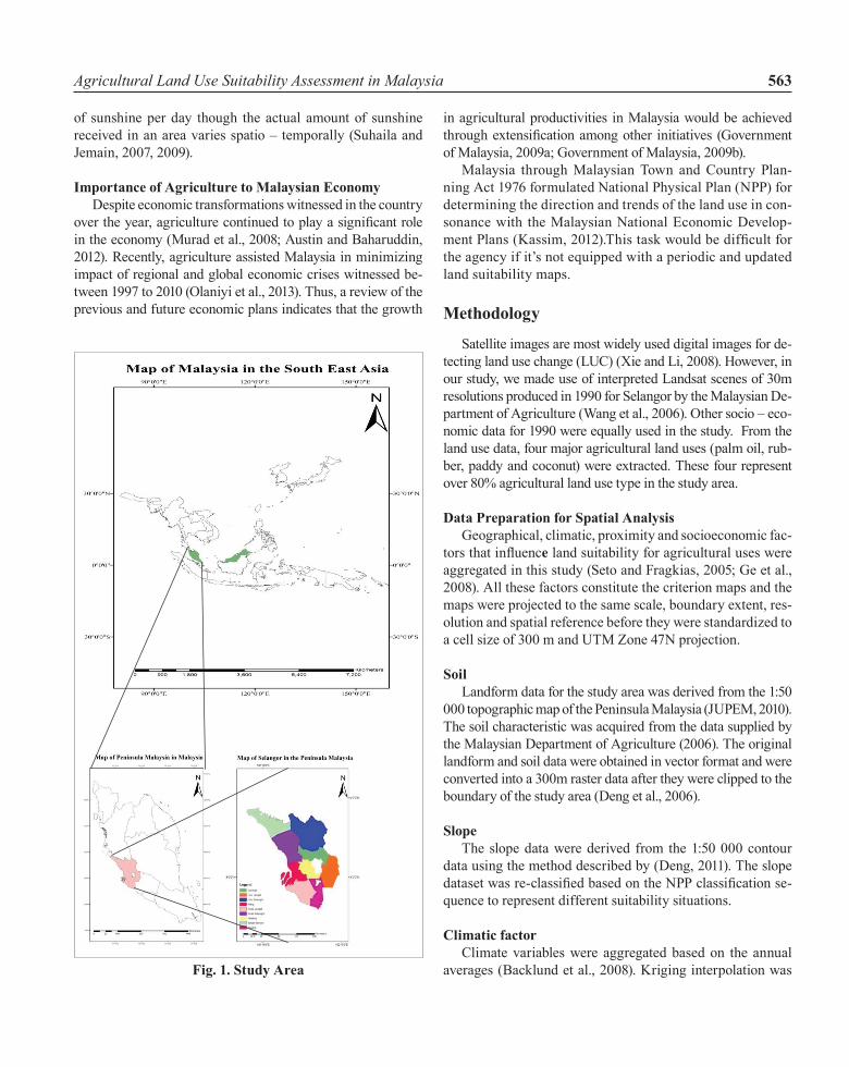
Study Area Malaysia lies within latitudes ½ o and 7o N and longitudes
100o to 1191/2o E with land area of 336 745 km2 (Wong et al.,
2009). Malaysia is bordered by Thailand in the North, South China Sea in the East and West and Singapore and Indonesia in the South (Suhaila and Jemain, 2007, 2009) Malaysia is divided into three political parts namely Peninsular Malaysia (131 587 km2), Sabah (73 711 km2) and Sarawak (123 466 km2) (Figure 1).
Malaysia has a characteristically humid tropical climate (Suhaila and Jemain, 2009; Government of Malaysia, 2009; Austin and Baharuddin, 2012) with variable topography. For example, the Peninsular Malaysia has a central mountain ranges extending from North to South (Suhaila and Jemain, 2007) with either sedentary or strongly weathered rock, kao-linitic clay minerals or of coastal alluvial plains (Tham and Kerridge, 1982). The wind is generally light and variable with strong influence on the season in Malaysia. For instance, the Southwesterly monsoon wind prevails in May and ends in September while, the Northeasterly winds prevail in Novem-ber until March (Suhaila and Jemain, 2007; Suhaila et al., 2010; Jasim et al., 2013).
Malaysia has relatively uniform temperature all the year round with annual variation of about 2°C and daily range of 5°C to 12°C (Suhaila and Jemain, 2007; Suhaila et al., 2010; Jasim et al., 2013). The mean monthly relative humidity in Malaysia is between 70 to 90%. Malaysia has about 6 hours
Table 1 Satty ScaleIntensity of Importance
Verbal judgment of preference of the criteria
1 Two criteria are equally important
3 One criterion is moderately important than the other
5 One criterion is strongly important than the other
7 One criterion is extremely important than the other
9 One criterion is extremely more important than the other
2, 4, 6, 8 Intermediate values between adjacent scales values
Source: (Saaty and Vargas, 1991)
Agricultural Land Use Suitability Assessment in Malaysia 563
of sunshine per day though the actual amount of sunshine received in an area varies spatio – temporally (Suhaila and Jemain, 2007, 2009).
Importance of Agriculture to Malaysian Economydespite economic transformations witnessed in the country
over the year, agriculture continued to play a significant role in the economy (Murad et al., 2008; Austin and Baharuddin, 2012). Recently, agriculture assisted Malaysia in minimizing impact of regional and global economic crises witnessed be-tween 1997 to 2010 (Olaniyi et al., 2013). Thus, a review of the previous and future economic plans indicates that the growth
in agricultural productivities in Malaysia would be achieved through extensification among other initiatives (Government of Malaysia, 2009a; Government of Malaysia, 2009b).
Malaysia through Malaysian Town and Country Plan-ning Act 1976 formulated National Physical Plan (NPP) for determining the direction and trends of the land use in con-sonance with the Malaysian National Economic develop-ment Plans (Kassim, 2012).This task would be difficult for the agency if it’s not equipped with a periodic and updated land suitability maps.
Methodology
Satellite images are most widely used digital images for de-tecting land use change (LUC) (Xie and Li, 2008). However, in our study, we made use of interpreted Landsat scenes of 30m resolutions produced in 1990 for Selangor by the Malaysian de-partment of Agriculture (Wang et al., 2006). Other socio – eco-nomic data for 1990 were equally used in the study. From the land use data, four major agricultural land uses (palm oil, rub-ber, paddy and coconut) were extracted. These four represent over 80% agricultural land use type in the study area.
Data Preparation for Spatial AnalysisGeographical, climatic, proximity and socioeconomic fac-
tors that influence land suitability for agricultural uses were aggregated in this study (Seto and Fragkias, 2005; Ge et al., 2008). All these factors constitute the criterion maps and the maps were projected to the same scale, boundary extent, res-olution and spatial reference before they were standardized to a cell size of 300 m and uTM Zone 47N projection.
SoilLandform data for the study area was derived from the 1:50
000 topographic map of the Peninsula Malaysia (JuPEM, 2010). The soil characteristic was acquired from the data supplied by the Malaysian department of Agriculture (2006). The original landform and soil data were obtained in vector format and were converted into a 300m raster data after they were clipped to the boundary of the study area (deng et al., 2006).
SlopeThe slope data were derived from the 1:50 000 contour
data using the method described by (deng, 2011). The slope dataset was re-classified based on the NPP classification se-quence to represent different suitability situations.
Climatic factorClimate variables were aggregated based on the annual
averages (Backlund et al., 2008). Kriging interpolation was
Fig. 1. Study Area
A. O. Olaniyi, A. J. Ajiboye, A. M. Abdullah, M. F. Ramli and A. M. Sood564
used to determine the spatial approximations and to calculate the value of the variables for each grid (Aguiar et al., 2007; deng, 2011). The socio economic variables (total population, age class, housing density, urban work force, rural work force, agricultural GdP, non agricultural GdP) obtained from the Malaysian departments of Statistics (MdoS) were interpo-lated by spline algorithm before being converted into a raster data of 300 m grid scale (deng, 2011).
Accessibility FactorsAccessibility data were derived from the 1:50 000 topo-
graphic maps and was reclassified as national major road, mi-nor road, and major railway line before being rasterized a 300 m pixel (deng, 2011).
Constraint MapsThree constraint maps were introduced into the study.
These constraint maps represented areas that are restricted from conversion into agricultural uses as a result of policy (wildlife conservation areas, protected forests), biophysical constraints (difficult terrains and water bodies). All these area were excluded from further mapping into agricultural suitability because they were considered unsuitable or un-available for agricultural purposes (Figure 2).
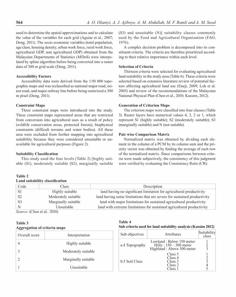
Suitability ClassificationThis study used the four levels (Table 2) [highly suit-
able (S1), moderately suitable (S2), marginally suitable
(S3) and unsuitable (N)] suitability classes commonly used by the Food and Agricultural Organization (FAO, 1976).
A complex decision problem is decomposed into its con-stituent criteria. The criteria are therefore prioritized accord-ing to their relative importance within each level.
Selection of CriteriaThirteen criteria were selected for evaluating agricultural
land suitability in the study area (Table 6). These criteria were selected based on extensive literature review of potential fac-tors affecting agricultural land use (Eneji, 2009; Loh et al. 2003) and review of the recommendations of the Malaysian National Physical Plan (Chen et al., 2010; Kassim, 2012).
Generation of Criterion MapsThe criterion maps were classified into four classes (Table
3). Raster layers have numerical values 4, 3, 2 or 1, which represent S1 (highly suitable); S2 (moderately suitable); S3 (marginally suitable) and N (not suitable).
Pair wise Comparison Matrix Normalized matrix was obtained by dividing each ele-
ment in the column of a PCM by its column sum and the pri-ority vector was obtained by finding the average of each row of the normalized matrix. Since comparisons between crite-ria were made subjectively, the consistency of this judgment were verified by evaluating the Consistency Ratio (CR):
Table 2 Land suitability classification Code Class descriptionS1 highly suitable land having no significant limitation for agricultural productivity S2 Moderately suitable land having some limitations that are severe for sustained productivityS3 Marginally suitable land with major limitations for sustained agricultural productivityN unsuitable land with extreme limitations for sustained agricultural productivity
Source: (Chen et al.. 2010)
Table 3 Aggregation of criteria maps
Overall score Interpretation
4 highly suitable
3 Moderately suitable
2 Marginally suitable
1 unsuitable
Table 4 Sub criteria used for land suitability analysis (Kassim 2012)
Sub objectives Attributes Suitability class
a.4 TopographyLowland : Below 150 meter
hilly : 150 – 300 meterhighland : Above 300 meter
123
b.5 Soil Class
Class 5Class 4Class 3Class 2Class 1
12345
Agricultural Land Use Suitability Assessment in Malaysia 565
Constraint map 1
Overall factor map
Suitability Map
Multiply
Overall constraint
map 1
Multiply
Multiply by corresponding weights
Summation of weighted maps
Weighted map 7
Weighted map 6
Weighted map 5
Weighted map 4
Weighted map 3
Weighted map 1
Factor map 6
Weighted map 2
Factor map 5
Factor map 4
Factor map 3
Factor map 2
Factor map 1
Constraint map 3
Constraint map 2
Factor map 8
Factor map 7
Weighted map 8
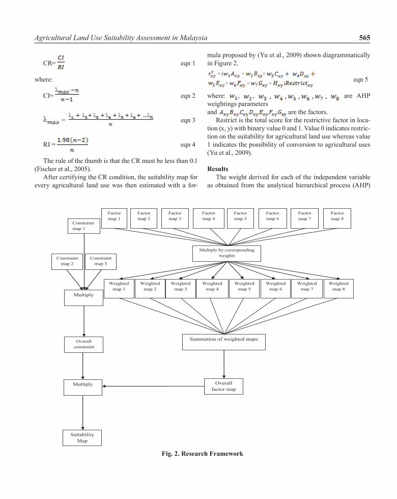
Fig. 2. Research Framework
=
= ( + + + + + )
, ,
=
= ( + + + + + )
, ,
CR=
=
= ( + + + + + )
, ,
eqn 1
where:
CI= eqn 2
= eqn 3
RI = eqn 4
The rule of the thumb is that the CR must be less than 0.1 (Fischer et al., 2005).
After certifying the CR condition, the suitability map for every agricultural land use was then estimated with a for-
mula proposed by (Yu et al., 2009) shown diagrammatically in Figure 2.
eqn 5
where: , , are AhP weightings parameters and
=
= ( + + + + + )
, ,
are the factors.Restrict is the total score for the restrictive factor in loca-
tion (x, y) with binary value 0 and 1. Value 0 indicates restric-tion on the suitability for agricultural land use whereas value 1 indicates the possibility of conversion to agricultural uses (Yu et al., 2009).
Results The weight derived for each of the independent variable
as obtained from the analytical hierarchical process (AhP)
A. O. Olaniyi, A. J. Ajiboye, A. M. Abdullah, M. F. Ramli and A. M. Sood566
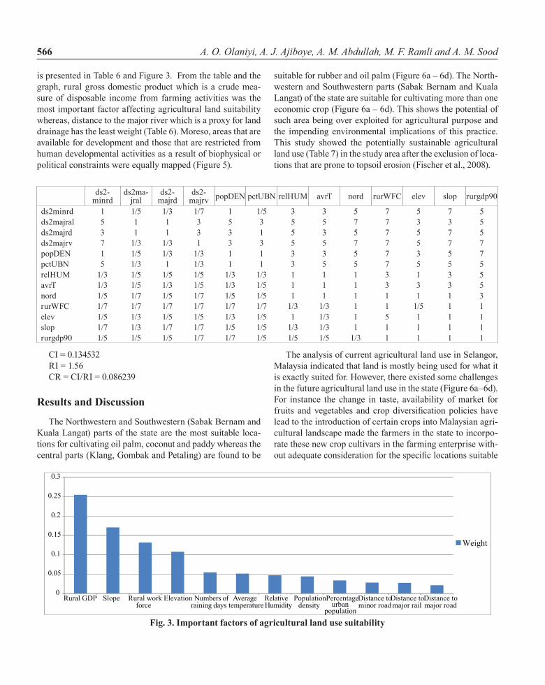
is presented in Table 6 and Figure 3. From the table and the graph, rural gross domestic product which is a crude mea-sure of disposable income from farming activities was the most important factor affecting agricultural land suitability whereas, distance to the major river which is a proxy for land drainage has the least weight (Table 6). Moreso, areas that are available for development and those that are restricted from human developmental activities as a result of biophysical or political constraints were equally mapped (Figure 5).
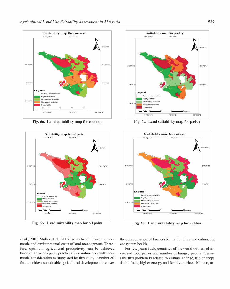
suitable for rubber and oil palm (Figure 6a – 6d). The North-western and Southwestern parts (Sabak Bernam and Kuala Langat) of the state are suitable for cultivating more than one economic crop (Figure 6a – 6d). This shows the potential of such area being over exploited for agricultural purpose and the impending environmental implications of this practice. This study showed the potentially sustainable agricultural land use (Table 7) in the study area after the exclusion of loca-tions that are prone to topsoil erosion (Fischer et al., 2008).
ds2- minrd
ds2ma-jral
ds2-majrd
ds2- majrv popdEN pctuBN relhuM avrT nord rurWFC elev slop rurgdp90
ds2minrd 1 1/5 1/3 1/7 1 1/5 3 3 5 7 5 7 5ds2majral 5 1 1 3 5 3 5 5 7 7 3 3 5ds2majrd 3 1 1 3 3 1 5 3 5 7 5 7 5ds2majrv 7 1/3 1/3 1 3 3 5 5 7 7 5 7 7popdEN 1 1/5 1/3 1/3 1 1 3 3 5 7 3 5 7pctuBN 5 1/3 1 1/3 1 1 3 5 5 7 5 5 5relhuM 1/3 1/5 1/5 1/5 1/3 1/3 1 1 1 3 1 3 5avrT 1/3 1/5 1/3 1/5 1/3 1/5 1 1 1 3 3 3 5nord 1/5 1/7 1/5 1/7 1/5 1/5 1 1 1 1 1 1 3rurWFC 1/7 1/7 1/7 1/7 1/7 1/7 1/3 1/3 1 1 1/5 1 1elev 1/5 1/3 1/5 1/5 1/3 1/5 1 1/3 1 5 1 1 1slop 1/7 1/3 1/7 1/7 1/5 1/5 1/3 1/3 1 1 1 1 1rurgdp90 1/5 1/5 1/5 1/7 1/7 1/5 1/5 1/5 1/3 1 1 1 1
CI = 0.134532RI = 1.56CR = CI/RI = 0.086239
Results and Discussion
The Northwestern and Southwestern (Sabak Bernam and Kuala Langat) parts of the state are the most suitable loca-tions for cultivating oil palm, coconut and paddy whereas the central parts (Klang, Gombak and Petaling) are found to be
The analysis of current agricultural land use in Selangor, Malaysia indicated that land is mostly being used for what it is exactly suited for. however, there existed some challenges in the future agricultural land use in the state (Figure 6a–6d). For instance the change in taste, availability of market for fruits and vegetables and crop diversification policies have lead to the introduction of certain crops into Malaysian agri-cultural landscape made the farmers in the state to incorpo-rate these new crop cultivars in the farming enterprise with-out adequate consideration for the specific locations suitable
0
0.05
0.1
0.15
0.2
0.25
0.3
Rural GDP Slope Rural workforce
Elevation Numbers ofraining days
Averagetemperature
RelativeHumidity
Populationdensity
Percentageurban
population
Distance tominor road
Distance tomajor rail
Distance tomajor road
Weight
Fig. 3. Important factors of agricultural land use suitability
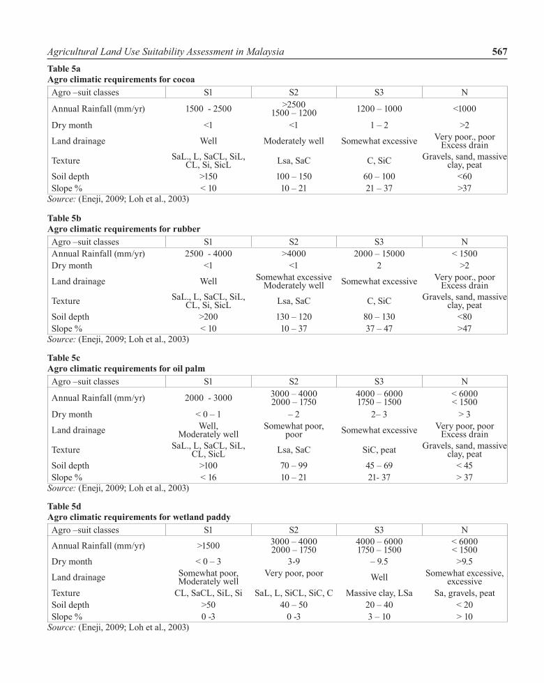
Agricultural Land Use Suitability Assessment in Malaysia 567Table 5a Agro climatic requirements for cocoa Agro –suit classes S1 S2 S3 N
Annual Rainfall (mm/yr) 1500 - 2500 >25001500 – 1200 1200 – 1000 <1000
dry month <1 <1 1 – 2 >2
Land drainage Well Moderately well Somewhat excessive Very poor., poor Excess drain
Texture SaL., L, SaCL, SiL, CL, Si, SicL Lsa, SaC C, SiC Gravels, sand, massive
clay, peatSoil depth >150 100 – 150 60 – 100 <60Slope % < 10 10 – 21 21 – 37 >37
Source: (Eneji, 2009; Loh et al., 2003)
Table 5b Agro climatic requirements for rubber Agro –suit classes S1 S2 S3 NAnnual Rainfall (mm/yr) 2500 - 4000 >4000 2000 – 15000 < 1500dry month <1 <1 2 >2
Land drainage Well Somewhat excessiveModerately well Somewhat excessive Very poor., poor
Excess drain
Texture SaL., L, SaCL, SiL, CL, Si, SicL Lsa, SaC C, SiC Gravels, sand, massive
clay, peatSoil depth >200 130 – 120 80 – 130 <80Slope % < 10 10 – 37 37 – 47 >47
Source: (Eneji, 2009; Loh et al., 2003)
Table 5c Agro climatic requirements for oil palm Agro –suit classes S1 S2 S3 N
Annual Rainfall (mm/yr) 2000 - 3000 3000 – 40002000 – 1750
4000 – 60001750 – 1500
< 6000< 1500
dry month < 0 – 1 – 2 2– 3 > 3
Land drainage Well, Moderately well
Somewhat poor, poor Somewhat excessive Very poor, poor
Excess drain
Texture SaL., L, SaCL, SiL, CL, SicL Lsa, SaC SiC, peat Gravels, sand, massive
clay, peatSoil depth >100 70 – 99 45 – 69 < 45Slope % < 16 10 – 21 21- 37 > 37
Source: (Eneji, 2009; Loh et al., 2003)
Table 5d Agro climatic requirements for wetland paddy Agro –suit classes S1 S2 S3 N
Annual Rainfall (mm/yr) >1500 3000 – 40002000 – 1750
4000 – 60001750 – 1500
< 6000< 1500
dry month < 0 – 3 3-9 – 9.5 >9.5
Land drainage Somewhat poor, Moderately well
Very poor, poor Well Somewhat excessive, excessive
Texture CL, SaCL, SiL, Si SaL, L, SiCL, SiC, C Massive clay, LSa Sa, gravels, peatSoil depth >50 40 – 50 20 – 40 < 20Slope % 0 -3 0 -3 3 – 10 > 10
Source: (Eneji, 2009; Loh et al., 2003)
A. O. Olaniyi, A. J. Ajiboye, A. M. Abdullah, M. F. Ramli and A. M. Sood568
for the growing of these crops. While the farmers have a short term goal of increasing their farm income from this practice, the resulting environmental degradation from this practice could jeopardize their ambition in the long term. Therefore, it is crucial to consider the environmental requirements of these crops vis–a–vis the biophysical capacities of the land in order to balance the crop requirements with the land bio-physical capabilities.
In the recent times, insufficient agricultural production/food insecurity as a result of reduction in agricultural invest-ments, increasing costs of production, shortages of agricul-
tural labour, degradation of agricultural resources, water scarcity, climate change and globalization have caused in-crease pressure on land utilization.
In addition, the wave of urbanization and industrialization witnessed in the developing nations of the world has increase the competitiveness of land as a factor of production. Given the decreasing rate of food production and reduction in farm labour, loss of arable land to degradation and conversion to non-agricultural uses and loss of genetic resources. As global population and food demand increases, there an urgent need to utilize land resources according to its suitability (Elaalem
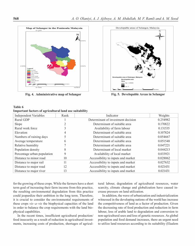
Table 6 Important factors of agricultural land use suitabilityIndependent Variables Rank Indicator WeightsRural GdP 1 determinant of investment decision 0.254982Slope 2 determinant of suitable area 0.170822Rural work force 3 Availability of farm labour 0.131535Elevation 4 determinant of suitable area 0.107824Numbers of raining days 5 determinant of suitable area 0.054667Average temperature 6 determinant of suitable area 0.051548Relative humidity 7 determinant of suitable area 0.047221Population density 8 determinant of local market 0.044213Percentage urban population 9 Availability of local market 0.033921distance to minor road 10 Accessibility to inputs and market 0.028062distance to major rail 11 Accessibility to inputs and market 0.027632distance to major road 12 Accessibility to inputs and market 0.021431distance to major river 13 Accessibility to inputs and market 0.021431
Fig. 4. Administrative map of Selangor
Fig. 5. Developable Areas in Selangor
Agricultural Land Use Suitability Assessment in Malaysia 569
et al., 2010; Müller et al., 2009) so as to minimize the eco-nomic and environmental costs of land management. There-fore, optimum agricultural productivity can be achieved through agroecological practices in combination with eco-nomic consideration as suggested by this study. Another ef-fort to achieve sustainable agricultural development involves
the compensation of farmers for maintaining and enhancing ecosystem health.
For few years back, countries of the world witnessed in-creased food prices and number of hungry people. Gener-ally, this problem is related to climate change, use of crops for biofuels, higher energy and fertilizer prices. Moreso, ur-
Fig. 6b. Land suitability map for oil palm
Fig. 6c. Land suitability map for paddy
Fig. 6d. Land suitability map for rubber
Fig. 6a. Land suitability map for coconut
A. O. Olaniyi, A. J. Ajiboye, A. M. Abdullah, M. F. Ramli and A. M. Sood570
banization and industrialization in conjunction with climate change are increasing pressures on agricultural land. With changing climate, it is obvious that the suitability of a par-ticular location for growing specific crops will not remain permanent indefinitely. Therefore there is a need to regu-larly update our knowledge of agro-climatic suitability of crops with availability of new crop cultivars and climatic incidences.
despite perceived shortcomings in this study, the out-come of this study could still be useful in assessing the po-tential yield and environmental degradation of the cultivated land. Moreover, it is equally useful to compare environmen-tal degradation among districts of Selangor in order to assess and document environmental problems associated with each agricultural land use for appropriate mitigation actions. Fi-nally, this study could be useful in estimating the potential conflict of interests amongst various land uses which would be useful in land use planning. Moreso, this study could be replicated in other states within Malaysia in order to know whether the trend in Selangor is similar to the other states despite different socio-economic and biophysical conditions that might influence land use decisions in those states (Ab-dullah and hezri, 2008).
Conclusions
This study has revealed the potential agricultural land in Selangor, Malaysia. unfortunately, available evidence showed that some of these agricultural lands are being tak-en up by non – agricultural uses and this has a potential of negatively affecting the country’s food security. In the other hand, the scenario could create a situation where the coun-try may be achieving her food security at greater economic and environmental costs. For crops to be matched with the biophysical conditions, the biophysical variables (climatic, geomorphological, and number of raining days, average tem-perature, and relative humidity) of the study area were col-lected to enable the interpretation of the climatic variables with reference to their suitability for specific crop production. The climatic adaptability of crops forms the basis of defin-ing the crop-climatic requirement. For crops to be matched with the socio-economic variables, relevant socio-economic variables (rural income, agriculture labour, urbanization, ac-cessibility) of the study area were aggregated to enable the interpretation of the socio-economic variables with reference to their suitability for crop production. The socio-economic adaptability of crops forms the basis of defining the crop-social requirements. Places suitable for multiple crops were potential areas where agricultural productivities could have higher environmental impacts.
AppreciationThe authors wish to express their gratitude to the Malay-
sian department of Agriculture (MdoA) for providing the datasets used in this study and also appreciate the comments of the anonymous reviewers for their comments in improving the manuscript.
ReferencesAbdullah, S. A. and A. A. Hezri, 2008. From forest landscape
to agricultural landscape in the developing tropical country of Malaysia: pattern, process, and their significance on policy. En-vironmental Management, 42: 907–917.
Aguiar, A. P. D., G. Camara and M. I. S. Escada, 2007. Spa-tial statistical analysis of land-use determinants in the Brazilian Amazonia: Exploring intra-regional heterogeneity. Ecological Modeling, 2–4: 169–188.
Amini, M., M. Afyuni, N. Fathianpour, H. Khademi and H. Fluhler, 2005. Continuous soil pollution mapping using fuzzy logic and spatial interpolation. Geoderma, 124: 223-233.
Anagnostopoulos, K. P., A. P. Vavatsikos, N. Spiropoulos et al., 2010. Land suitability analysis for natural wastewater treatment systems using a new GIS add-in for supporting criterion weight elicitation methods. Operational Research, 10: 91–108.
Austin, O. C. and H. A. Baharuddin, 2012. Risk in Malaysian Agriculture the need for a strategic approach and policy refocus. Kajian Malaysia, 30: 21 – 50.
Backlund, P., A. C. Janetos and D. Schimel, 2008. The effects of climate change on agriculture, land resources, water resources and biodiversity. Climate Change Science Programm Synthesis and Assessment Product 4.3, Washington, D.C.
Baja, S., M. D. Chapman and D. Dragonvich, 2002. A concep-tual model for defining and assessing land management units using a fuzzy modeling approach in GIS environment. Environ. Manage, 29 (5): 647-661
Boroushaki, S. and J. Malczewski, 2008. Implementing an exten-sion of the analytical hierarchy process using ordered weighted averaging operators with fuzzy quantifiers in ArcGIS. Comput-ers and Geosciences, 4: 399 – 410.
Braimoh, A. K. and A. Stein, 2004. Land evaluation for Maize based on Fuzzy set and interpolation. Environ. Manage, 33 (2): 226-238.
Chen, Y., S. Khan and Z. Paydar, 2010. To retire or expand? A fuzzy GIS-based spatial multicriteria evaluation framework for irrigated agriculture. Irrigation and Drainage, 2: 174 - 188.
Corona, P., R. Salvati, A. Barbati et al., 2008. Land suitability for short rotation coppices assessed through fuzzy membership func-tions. In: R. Lafortezza, et al., eds. Patterns and processes in for-est landscapes. dordrecht, The Netherlands: Springer, 191–211.
De la Rosa, D., F. Mayol, E. Diaz-Pereira, M. Fernandez and D. Jr. De la Rosa, 2004. A land evaluation decision support sys-tem (MicroLEIS dSS) for agricultural soil protection. Environ. Modell. Softw., 19: 929-942.
Burrough, P. A., R. A. MacMillan and W. Van Denrsen, 1992. Fuzzy classification methods for determining land suitability from soil profile observations and topography. Soil Sci., 43: 193-210.
Agricultural Land Use Suitability Assessment in Malaysia 571
Deng, X., 2011. Modeling the dynamics and consequences of land system change. Higher Education Press, China (eds), 250 pp..
Deng, X. Z., J. K. Huang, S. Rozelle et al., 2006. Cultivated land conversion and potential agricultural productivity in China. Land Use Policy, 4: 372–384.
Deng, X. Z., J. Y. Liu, D. F. Zhuang et al., 2002. Modeling the relationship of land use change and some geophysical indicators for the interlock area of farming and pasturing in China. Jour-nal of Geographical Sciences, 4: 397- 404.
Dent, D. and A. Young, 1981. Soil survey and land evaluation. George Allen and uniwin: Boston. FAO. (1976). A framework for land evaluation. FAO Soils Bulletin 32, Rome.
Elaalem, M., A. Comber and P. Fisher, 2010. Land suitability analysis comparing Boolean logic with fuzzy analytic hierarchy process. Accuracy Symposium July, 20 – 23 Leicester.
Emadi, M, M. Baghernejad, M. Pakparvar and S. A. Kowsar, 2010. An approach for land suitability evaluation using geostatis-tics, remote sensing, and geographic information system in arid and semiarid ecosystems. Environ. Monit. Assess., 164: 501-511.
Eneji, A. E., 2009. Agronomy of tropical crops Studium Press Lim-ited, pp. 354.
FAO, 1976. A framework for land evaluation (Soils Bulletin No. 32). Rome: Food and Agriculture Organization of the united Nations.
FAO, 1984. Guidelines: Land evaluation for rainfed agriculture. FAO Soils Bulletin 52, Rome.
FAO, 2012. Natural Resources Assessment for Crop and Land Suit-ability: An Application for selected bioenergy crops in Southern Africa region. Integrated Crop Management, 14: ISBN 978-92-5-107218-9.
Fritz, S. and L. See, 2005. Comparison of land cover maps using fuzzy agreement. International Journal of Geographical Infor-mation Science, 19 (7): 787-807.
Feng, Qi, A-Xing Zhu, M. Harrower and J. E. Burt, 2006. Fuzzy soil mapping based on prototype category theory. Geoderma, 136: 774-787.
Fischer, G., S. Prieler and H. van Velthuizen, 2005. Biomass potentials of miscanthus, willow and poplar: results and policy implications for Eastern Europe, Northern and Central Asia. Biomass and Bioenergy, 2: 119 - 132.
Fischer, G., F. Nachtergaele, S. Prieler et al., 2008. Global agro-ecological zones assessment for agriculture (GAEZ 2008). IIA-SA/FAO, Laxenburg, Austria/Rome, Italy.
Flamant, J. C., C. Beranger and A. Gibon, 1999. Animal produc-tion and land use sustainability - approach from farm diversity at territory level. Livestock Prod. Sci., 61: 275 – 286.
Ge, Q. S., J. H. Dai, F. N. He et al., 2008. Land use changes and their relations with carbon cycles over the past 300 years in Chi-na. Science in China Series D – Earth Sciences, 6: 871 – 884.
Giordano, L. C. and P. S. Riedel, 2008. Multi-criteria spatial decision analysis for demarcation of greenway: a case study of the city of Rio Claro, Sa˜o Paulo, Brazil. Landscape and Urban Planning, 84: 301–311.
Goodchild, M. F., 2000. The current status of GIS and spatial analysis. Geographical Systems, 1: 5–10.
Government of Malaysia, 1990. Third National Agricultural Pol-icy, p. 5.
Government of Malaysia, 2009. New economic model. National economic advisory Council - a New Economic Model for Ma-laysia Part 1: Strategic Policy directions.
Government of Malaysia, 1985. Second Malaysia plan agriculture forestry and fishing (Rancangan Malaysia Kedua) Chapter 9.
Government of Malaysia, 2009b. Vision 2020 national economic advisory council.New economic model for Malaysia Part 1, Strategic Policy directions.
Hubner, R. and H. O. Gunther, 2007. using AhP for strategic production site assessment: a case study from specialty chemi-cals industry. In: H. O. Gu¨nther, D. C. Mattfeld and L.Suhl, eds. Management logistischernetzwerke, entscheidungsunter-stu¨ tzung, informations systeme und OR-tools. Heidelberg: Physica-Verlag, pp. 3–22.
Jia, Y., A. B. Yun, C. D. Chen et al., 2009. Cellular automata based spatial multicriteria land suitability simulation for irri-gated agriculture.
Joerin, F., M. Theriault and A. Musy, 2001. using GIS and outrank-ing multicriteria analysis for land use suitability assessment. Inter-national Journal of Geographical Information Science, 2: 153–174.
Jabatan Ukur Dan Pemetaan Malaysia (JuPEM), 2010.Jasim, M. R., M. Z. Mat Jafri and H. S. Lim, 2013. Combin-
ing multiple regression and principal component analysis for accurate predictions for column ozone in Peninsular Malaysia. Atmospheric Environment, 71: 36 - 43.
Kassim, N. S. B., 2011. The Application of decision Support Sys-tem in the Preparation of the National Physical Plan.
Kassim, N. S. B., 2012. Land use Planning and Information Sys-tem Geographical Information System in Land use Planning: directions and Implementations.
Keshavarzi, A. and F. Sarmadian, 2009. Investigation of fuzzy set theory’s efficiency in land suitability assessment for irrigat-ed wheat in Qazvin province using Analytic hierarchy process (AhP) and multivariate regression methods. Proc. Pedometrics 2009’ Conf, August 26-28, Beijing, China.
Keshavarzi, A., F. Sarmadian A. Ahmadi, 2011. Spatially-based model of land suitability analysis using Block Kriging. AJCS, 5 (12): 1533-1541.
Kurtener, D., E. Krueger-Shvetsova and I. Dubitskaia, 2004. Quality estimation of data collection. In: udMS, UDMS Press, Giorggia-Venice. pp. 9101–9109.
Lambin, E. F., B. L. Turner and H. J. Geist et al., 2001. The causes of land-use and land-cover change: Moving beyond the myths. Global Environmental Change, 4: 261–269.
Littleboy, M., D. M. Smith and M. J. Bryant, 1996. Simulation modeling to determine suitability of agricultural land. Ecologi-cal Modeling, 86: 219–225.
Loh, K. F., M. Halid and N. Surip, 2003. Agro-Ecological zoning for south west Selangor using Remote Sensing and Geographic Infor-mation system. Available at: http://www.a-a-r-s.org/acrs/proceed-ing/ACRS1997/Papers/PS397-14.htm. Assessed on 27/05/2013
Malaysian Second National Communication to the UNFCC. This report is Malaysia’s Second National Communication (NC2) submitted to the United Nations Framework Convention on Climate Change (UNFCCC). Available at: http://www.nre.gov.my. Assessed on 27/05/2013
A. O. Olaniyi, A. J. Ajiboye, A. M. Abdullah, M. F. Ramli and A. M. Sood572
Malczewski, J., 2004. GIS-based land-use suitability analysis: a critical overview. Progress in Malczewski, J. & Rinner, C. (2005). Exploring multicriteria decision strategies in GIS with linguistic quantifiers: a case study of residential quality evalua-tion. Journal of Geographical Systems, 2: 249–268.
Müller, D., T. Kuemmerle and M. Rusu et al., 2009. Lost in tran-sition: determinants of post-socialist cropland abandonment in Romania. Journal of Land Use Science, 4: 109–129.
Murad, W. M., N. H. N. Mustapaha and C. Siwar, 2008. Review of Malaysian agricultural policies with regards to sustainability. American Journal of Environmental Sciences, 6: 608 – 614.
Murad, W. M., C. Siwar, N. H. N. Mustapaha et al., 2009. Emer-gence to develop an appraisal system for agricultural practices in Malaysia. Journal of Human Ecology, 3: 191– 198.
National Study: Malaysia. The role of agriculture in rural devel-opment in Malaysia pp. 98 –118.
Ninth Malaysian Plans. The Economic Planning unit Prime Min-ister’s department Putrajaya 2006. Available at: http://www.epu.gov.my/html/themes/epu/html/rm9/html/english.htm. As-sessed on 24th december, 2012.
Nourqolipour, R., R. M. Shariff and T. Buyong, 2011. Markov chain cellular automata for simulating the spatial patterns of oil palm plantation The 11th South East Asian Survey Congress and the 13th International Surveyors’ Congress, 2011, Kuala Lumpur, Malaysia. Planning, 1: 3–65.
Olaniyi, A. O., A. M. Abdullah, F. M. Ramli and M. S. Alias, 2013. Agricultural land use in Malaysia: an historical overview and implications for food security. Bulgarian Journal of Agri-cultural Science, 19: 60 – 69.
Reshmidevi, T. V., T. I. Eldho and R. Jana, 2009. A GIS-integrated fuzzy rule-based inference system for land suitability evaluation in agricultural watersheds. Agricultural Systems, 101: 101–109.
Rossiter, D. G., 1996. A theoretical framework for land evaluation. Geoderma, 72: 165-190.
Saaty, T. L., 1980. The analytic hierarchy process: planning, set-ting priorities, resource allocation. New York: McGraw hill In-ternational Book Cooperation. New York, NY, USA.
Saaty, T. L. and L. G. Vargas, 1991. Prediction, projection and fore-casting. dordrecht, The Netherlands: Kluwer Academic Publisher.
Sanchez, J. F., 2007. Applicability of knowledge-based and Fuzzy theory-oriented approaches to land suitability for upland rice and rubber. M.Sc. Thesis, ITC, the Netherland.
Sicat, R. S., E. J. M. Carranza and U. B. Nidumolu, 2005. Fuzzy modeling of farmers’ knowledge for land suitability classifica-tion. Agricultural Systems, 83: 49-75.
Seto, K. C. and M. Fragkias, 2005. Quantifying spatiotemporal patterns of urban land-use change in four cities of China with time series landscape metrics. Landscape Ecology, 7: 871–888.
Suhaila, J. and A. A. Jemain, 2007. Fitting daily rainfall amount in Malaysia using the normal transform distribution. Journal of Applied Science, 7: 1880–1886.
Suhaila, J. and A. A. Jemain, 2009. Investigating the impacts of adjoining wet days on the distribution of daily rainfall amounts in Peninsular Malaysia. Journal of Hydrology, 368: 17–25.
Suhaila, J., S. M. Deni, W. Z. W. Zin and A. A. Jemain, 2010. Trends in Peninsular Malaysia rainfall data during the south-
west monsoon and northeast monsoon seasons: 1975–2004. Sains Malaysiana, 39: 533–542.
Sys, C., 1985. Land Evaluation. Part Ι, И, Ш . ITC, University of Ghent, Belgium, 343 pp.
Tang, H., J. Debaveye, D. Ruan and E. Van Ranst, 1991. Land suitability classification based on fuzzy set theory. Ped-ologie, 3: 277-290.
Tang, H., E. Van Ranst and C. Sys, 1992. An approach to predict land production potential for irrigated and rainfed winter wheat in Pinan County, China. Soil Technology, 5: 213-224.
Tham, K. C. and P. C. Kerridge, 1982. Responses to lime, K, Mo and Cu by grass-legume pasture on some Ultisols and Oxisols of Peninsular Malaysia. MARDI Res. Bull., 10: 350-369.
The Sun Newspaper, 28 October, 1995.Third National Agricultural Policy of the Malaysian Govern-
ment, p 5.Triantafilis, J., W. T. Ward and A. B. McBratney, 2001. Land suit-
ability assessment in the Namoi Valley of Australia, using a contin-uous model. Amsterdam Journal of Soil Research, 39: 273–290.
Triantaphyllou, E. and S. H. Mann, 1995. using the analytical process for decision making in engineering applications: some challenges. International Journal of Industrial Engineering: Applications and Practice, 2 (No 1): 35-44.
Van Ranst, E., H. Tang, R. Groenemans and S. Sinthurahat, 1996. Application of Fuzzy logic to land suitability for rub-ber production in Peninsular Thailand. Geoderma, 70: 1-19.
Veldkamp, A. and E. F. Lambin, 2001. Predicting land-use change. Agriculture Ecosystems and Environment, 85: 1–6.
Vo, Quang, M., T. Le Quang and A. Yamada, 2003. delination and incorporation of socio-infrastructure database into GIS for land use planning in Tan Phu Thanh village, Chau Thanh District, Cantho Province: Land Use Analysis, Map Asia Con-ference, pp. 14–16.
Wang, F., G. B. Hall and T. Subaryono, 1990. Fuzzy information representation and processing in conventional GIS software: database design and applications. International Journal of Geo-graphical Information Systems, 3: 261–283.
Wang, H., X. Wang and H. Li, 2006. Land utilization situation in heilonjiang province based on quantitative geography model. Transactions of the Chinese Society of Agricultural Engineer-ing, 7: 70–74.
Wong, C. L., R. Venneker, S. Uhlenbrook, A. B. M. Jamil and Y. Zhou, 2009. Variability of rainfall in Peninsular. Malaysia.Hydrology, Earth System Science Discussion, 6: 5471–5503.
Xie, H. and H. Li, 2008. driving forces analysis of land use pat-tern changes based on logistic regression model in the farming pastoral zone: a case study of Ongiud Banner, Inner Mongolia. Geographical Research, 2: 294–304.
Yahaya, S., N. Ahmad and F. R. Abdalla, 2010. Multicriteria analysis for flood vulnerable areas in Hadejia – Jama’are River Basin, Nigeria. European Journal of Scientific Research, 1: 71–83.
Yu, J., Y. Chen and J. P. Wu, 2009. Cellular automata and GIS based land use suitability simulation for irrigated agriculture. 18th World IMACS/MODSIM Congress, Cairns, Australia 13 – 17th July, 2009. Available at: http://mssanz.org.au/modsim09.
Received February, 2, 2014; accepted for printing December, 2, 2014.