AGRICULTURAL IMPACT STATEMENT - DATCP Home … · AMP and BMPs and the Role of the Agricultural...
86
AGRICULTURAL IMPACT STATEMENT DATCP #4215 Oxford Replacement Natural Gas Pipelines Marquette County PSC # 6650-CG-258 WISCONSIN DEPARTMENT OF AGRICULTURE, TRADE AND CONSUMER PROTECTION PUBLISHED SEPTEMBER 29, 2017
-
Upload
nguyenhuong -
Category
Documents
-
view
215 -
download
0
Transcript of AGRICULTURAL IMPACT STATEMENT - DATCP Home … · AMP and BMPs and the Role of the Agricultural...

AGRICULTURAL IMPACT STATEMENT
DATCP
#4215
Oxford Replacement Natural Gas Pipelines Marquette County PSC # 6650-CG-258
WISCONSIN DEPARTMENT OF AGRICULTURE, TRADE AND CONSUMER PROTECTION
PUBLISHED SEPTEMBER 29, 2017


AGRICULTURAL IMPACT STATEMENT
DATCP #4215
Oxford Replacement Natural Gas Pipelines
Marquette County
WISCONSIN DEPARTMENT OF AGRICULTURE,
TRADE AND CONSUMER PROTECTION
Jeff Lyon, Interim Secretary
John Petty, Administrator
Division of Agricultural Resource Management
Keith Foye, Director
Bureau of Land and Water Resources
Sara Walling, Chief
Nutrient Management and Water Quality Section
Marilyn M. Weiss, Author
Alice Halpin, Author
Published September 29, 2017

Oxford Replacement Natural Gas Pipelines Agricultural Impact Statement
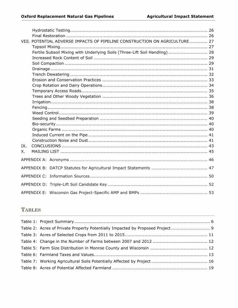
TABLE OF CONTENTS
DATCP SUMMARY OF ANALYSIS AND RECOMMENDATIONS ..................................................... 1
Recommendations to the Public Service Commission ..................................................... 1
Recommendations to Wisconsin Gas ............................................................................ 2
Recommendations to Agricultural Property Owners ........................................................ 2
INTRODUCTION ......................................................................................................... 4
PROJECT DESCRIPTION .............................................................................................. 6
Overview.................................................................................................................. 6
Project Purpose and Need .......................................................................................... 7
Description of Potential Routes.................................................................................... 7
ROW Requirements ................................................................................................... 8
Trench Dimensions .................................................................................................... 8
PROJECT IMPACTS TO AGRICULTURAL PROPERTIES ....................................................... 9
Easements ............................................................................................................... 9
Aboveground Facilities ............................................................................................. 10
Access Roads .......................................................................................................... 10
AGRICULTURAL SETTING .......................................................................................... 11
Agricultural Productivity ........................................................................................... 11
Land in Agriculture .................................................................................................. 11
Number and Size of Farms ....................................................................................... 12
Property Taxes and Values ....................................................................................... 12
Farmland Preservation ............................................................................................. 13
Conservation Reserve Program ................................................................................. 14
Conservation Reserve Enhancement Program ............................................................. 14
Drainage Districts .................................................................................................... 14
FARMLAND SOILS .................................................................................................... 15
Farmland Soil Definitions .......................................................................................... 15
Farmland Soils Affected by the Proposed Project ......................................................... 15
Three-Lift Soil Handling ............................................................................................ 17
AGRICULTURAL LANDOWNER IMPACTS ...................................................................... 19
DATCP Survey of Agricultural Property Owners ........................................................... 19
Property Owner Comments ....................................................................................... 20
AMP and BMPs and the Role of the Agricultural Inspector ............................................. 20
Appraisal and Compensation ..................................................................................... 20
CONSTRUCTION PROCESS ........................................................................................ 22
Surveying and Staking ............................................................................................. 22
Clearing, Grubbing, and Grading ............................................................................... 22
Pipe Stringing ......................................................................................................... 24
Bending and Welding ............................................................................................... 24
Trenching ............................................................................................................... 24
Lowering-In ............................................................................................................ 25
Trench Breakers and Tile Repairs .............................................................................. 25
Backfilling .............................................................................................................. 25
Horizontal Directional Drilling (HDD) and Jack and Boring ............................................ 25
Cleanup and Initial Restoration ................................................................................. 26
Oxford Replacement Natural Gas Pipelines Agricultural Impact Statement
Hydrostatic Testing.................................................................................................. 26
Final Restoration ..................................................................................................... 26
POTENTIAL ADVERSE IMPACTS OF PIPELINE CONSTRUCTION ON AGRICULTURE ............. 27
Topsoil Mixing ......................................................................................................... 27
Fertile Subsoil Mixing with Underlying Soils (Three-Lift Soil Handling) ............................ 28
Increased Rock Content of Soil ................................................................................. 29
Soil Compaction ...................................................................................................... 29
Drainage ................................................................................................................ 31
Trench Dewatering .................................................................................................. 32
Erosion and Conservation Practices ........................................................................... 33
Crop Rotation and Dairy Operations ........................................................................... 34
Temporary Access Roads .......................................................................................... 35
Trees and Other Woody Vegetation ........................................................................... 36
Irrigation................................................................................................................ 38
Fencing .................................................................................................................. 38
Weed Control .......................................................................................................... 39
Seeding and Seedbed Preparation ............................................................................. 40
Bio-security ............................................................................................................ 40
Organic Farms ........................................................................................................ 40
Induced Current on the Pipe ..................................................................................... 41
Construction Noise and Dust ..................................................................................... 41
CONCLUSIONS ........................................................................................................ 43
X. MAILING LIST ......................................................................................................... 45
APPENDIX A: Acronyms .................................................................................................. 46
APPENDIX B: DATCP Statutes for Agricultural Impact Statements ........................................ 47
APPENDIX C: Information Sources .................................................................................... 50
APPENDIX D: Triple-Lift Soil Candidate Key ....................................................................... 52
APPENDIX E: Wisconsin Gas Project-Specific AMP and BMPs ................................................ 53
TABLES
Table 1: Project Summary ................................................................................................. 6
Table 2: Acres of Private Property Potentially Impacted by Proposed Project ............................ 9
Table 3: Acres of Selected Crops from 2011 to 2015 ........................................................... 11
Table 4: Change in the Number of Farms between 2007 and 2012 ....................................... 12
Table 5: Farm Size Distribution in Monroe County and Wisconsin ......................................... 12
Table 6: Farmland Taxes and Values ................................................................................. 13
Table 7: Working Agricultural Soils Potentially Affected by Project ........................................ 16
Table 8: Acres of Potential Affected Farmland .................................................................... 19

Oxford Replacement Natural Gas Pipelines Agricultural Impact Statement
FIGURES
Figure 1: Project Overview Map ......................................................................................... 5
Figure 2: Types of Farmland Affected by the Proposed Project ............................................. 10
Figure 3: Soil Classification .............................................................................................. 16
Figure 4: Typical Pipeline Construction Cross-Section on Agricultural Land ............................ 23

Oxford Replacement Natural Gas Pipelines Agricultural Impact Statement
Wisconsin Department of Agriculture, Trade and Consumer Protection 1
DATCP SUMMARY OF ANALYSIS AND RECOMMENDATIONS
The Wisconsin Department of Agriculture, Trade and Consumer Protection (DATCP) has prepared
this Agricultural Impact Statement (AIS) for the proposed Oxford Replacement Natural Gas
Pipelines (DATCP #4215) in accordance with Wis. Stat. §32.035. Wisconsin Gas LLC (Wisconsin
Gas) submitted information about this project to DATCP in July and August of 2017. The project
proposes to replace approximately 8.6 miles of existing pipeline with 6-inch and 4-inch pipelines.
The project has 3 segments located within the towns of Packwaukee T15N R9E, Harris T16N-R9E,
and Westfield T16N-R8E in Marquette County. No alternative routes were proposed. Most
affected property owners have an existing natural gas easement on their property, however,
construction would impact these existing easements as well as require new temporary and
permanent easements for the replacement pipelines. Additional property owners may also be
affected through the acquisition of permanent and temporary easements. The existing pipelines
would be abandoned in-place. The Public Service Commission of Wisconsin (PSC) is the authority
that will approve, deny, or make modifications to this project.
As part of its review of the project, DATCP sent a questionnaire to agricultural property owners
who may have three or more acres of easement affected by the proposed project if the project is
approved by the PSC. Of the 35 private property owners that might be affected by the proposed
project, 25 are agricultural properties and five of those could have three or more acres affected
by this project. One landowner responded to the survey.
Having reviewed all of the materials provided by Wisconsin Gas and the comments from property
owners, DATCP recommends the following to the PSC, Wisconsin Gas, and to agricultural property
owners to mitigate impacts to farmland and farmland operations.
Recommendations to the Public Service Commission
One aboveground facility may be constructed as part of this project. DATCP
recommends that this facility be located so as to minimize impacts to actively farmed
land and that Wisconsin Gas work with the affected landowner to determine the
location and size of the facility on their property.
The Agricultural Mitigation Plan (AMP) and Best Management Practices (BMPs)
supplied by Wisconsin Gas are effective tools in mitigating potential impacts to farm
properties. DATCP recommends that Wisconsin Gas implement appropriate training
for all construction supervisors, inspectors, and crews to ensure that they understand
the implementation of the AMP and BMPs so that the integrity of agricultural lands
and operations during project construction and restoration are protected.

Oxford Replacement Natural Gas Pipelines Agricultural Impact Statement
Wisconsin Department of Agriculture, Trade and Consumer Protection 2
Recommendations to Wisconsin Gas
Wisconsin Gas should ensure that any renters of agricultural land crossed by the
proposed project are kept up-to-date and informed of construction schedules and
potential impacts.
Wisconsin Gas should work with property owners and renters to minimize construction
impacts to farming operations and infrastructure.
Wisconsin Gas should work with landowners to restore agricultural properties
impacted by construction activities to pre-construction function and address concerns
resulting from construction.
Where construction activities have altered the natural stratification of the soils
resulting in new wet areas, Wisconsin Gas should work with the landowner to
determine the means to return the agricultural land either in the ROW or on adjoining
lands to pre-construction function. New drainage tiles, regrading, or additional fill
may be required to correct the problems that arise after construction is completed.
Wisconsin Gas should, to the extent practicable, limit the amount of permanent tree
clearing required from wood lots.
Recommendations to Agricultural Property Owners
Wisconsin Gas may offer landowners compensation to sign an appraisal waiver form
and an easement based on a market study. Landowners have the right to a free
appraisal (Wis. Stat. §32.06). Landowners should examine the language of any
waiver or easement contract carefully and verify that it contains all agreed-to terms.
Landowners should examine the language of any easement contract carefully and
verify that it contains all agreed-to terms. Landowners should be familiar with the
company’s project-specific AMP and BMPs (Appendix E) so as to determine if
additional conditions should be negotiated with the utility. Though landowners may
choose to waive any or all of the practices and procedures described in the AMP and
BMPs, DATCP recommends to only do so with careful consideration.
Landowners/operators should keep records of the condition of their land within the
right-of way (ROW) before, during, and after construction to document any impacts or
damage that occurs due to the proposed project. Documentation could include crop
yield records and photographs taken every season.
Landowners should identify to Wisconsin Gas where drainage tiles may be located in
the vicinity of the ROW. If drainage tiles are damaged by construction activities,
landowners should observe and photograph any drain tile repairs to ensure that they
are adequately repaired.

Oxford Replacement Natural Gas Pipelines Agricultural Impact Statement
Wisconsin Department of Agriculture, Trade and Consumer Protection 3
After construction is completed, landowners and the utility should carefully monitor
for the emergence of drainage problems. Once these problems are observed and if
they can be attributed to pipeline construction, the landowner should notify the utility
and the utility should take remediation steps as soon as possible.
Landowners with conservation easements within the ROW should consult with the
conservation program provider to determine if any effects will occur due to
construction of the project and alteration of the land. If the landowner is charged a
fee for any program non-compliance due to the proposed project, Wisconsin Gas
should compensate the landowner the amount of that fee.
DATCP recommends that any affected farm operation that has a written bio-security
plan, provide this plan to Wisconsin Gas.

Oxford Replacement Natural Gas Pipelines Agricultural Impact Statement
Wisconsin Department of Agriculture, Trade and Consumer Protection 4
INTRODUCTION
The Wisconsin Department of Agriculture, Trade and Consumer Protection (DATCP) has prepared
this agricultural impact statement (AIS) in accordance with Wis. Stat. §32.035. The AIS is an
informational and advisory document that describes and analyzes the potential effects of the
project on farm operations and agricultural resources, but it cannot stop a project. The DATCP is
required to prepare an AIS when the actual or potential exercise of eminent domain powers
involves an acquisition of interest in more than five acres of land from any farm operation. The
term farm operation includes all owned and rented parcels of land, buildings, equipment,
livestock, and personnel used by an individual, partnership, or corporation under single
management to produce agricultural commodities.
The AIS reflects the general objectives of the DATCP in its recognition of the importance of
conserving important agricultural resources and maintaining a healthy rural economy. DATCP is
not involved in determining whether or not eminent domain powers will be used or the amount of
compensation to be paid for the acquisition of any property. As stated in Wis. Stat.
§32.035(4)(d):
Waiting period. The condemnor may not negotiate with an owner or make a jurisdictional
offer under this subchapter until 30 days after the impact statement is published.
The full text of Wis. Stat. §32.035 is included in Appendix B. Additional references to statutes
that govern eminent domain and condemnation processes are included in Appendix B. Links to
other sources of information can be found in Appendix C.
The proposed project requires a Certificate of Authority (CA) from the Public Service Commission
of Wisconsin (PSC or Commission) before construction can begin. The PSC will analyze the need
for the project and the potential environmental and community impacts. The Commission will
approve, modify, or deny the utility’s application. Additional information about this project and
the PSC review process can be found on the PSC web site: http://psc.wi.gov/ under the PSC
docket number, 6650 CG-258
Wisconsin Gas has developed an Agricultural Mitigation Plan (AMP) and Best Management
Practices (BMPs) for this project. The AMP and BMPs describe the policies to be followed and
methods to be used by Wisconsin Gas to avoid or mitigate the potentially adverse impacts on
agricultural productivity from the construction of this pipeline. The AMP and BMPs are included in
Appendix E of this report.
During construction, Wisconsin Gas may employ an on-site Agricultural Inspector. The
Agricultural Inspector would be familiar with agricultural operations as well as gas pipeline
construction.

Oxford Replacement Natural Gas Pipelines Agricultural Impact Statement
Wisconsin Department of Agriculture, Trade and Consumer Protection 5
Figure 1: Project Overview Map
Oxford Replacement Natural Gas Pipelines Agricultural Impact Statement
Wisconsin Department of Agriculture, Trade and Consumer Protection 6
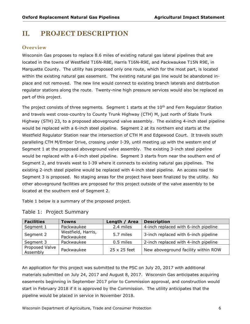
PROJECT DESCRIPTION
Overview
Wisconsin Gas proposes to replace 8.6 miles of existing natural gas lateral pipelines that are
located in the towns of Westfield T16N-R8E, Harris T16N-R9E, and Packwaukee T15N R9E, in
Marquette County. The utility has proposed only one route, which for the most part, is located
within the existing natural gas easement. The existing natural gas line would be abandoned in-
place and not removed. The new line would connect to existing branch laterals and distribution
regulator stations along the route. Twenty-nine high pressure services would also be replaced as
part of this project.
The project consists of three segments. Segment 1 starts at the 10th and Fern Regulator Station
and travels west cross-country to County Trunk Highway (CTH) M, just north of State Trunk
Highway (STH) 23, to a proposed aboveground valve assembly. The existing 4-inch steel pipeline
would be replaced with a 6-inch steel pipeline. Segment 2 at its northern end starts at the
Westfield Regulator Station near the intersection of CTH M and Edgewood Court. It travels south
paralleling CTH M/Ember Drive, crossing under I-39, until meeting up with the western end of
Segment 1 at the proposed aboveground valve assembly. The existing 3-inch steel pipeline
would be replaced with a 6-inch steel pipeline. Segment 3 starts from near the southern end of
Segment 2, and travels west to I-39 where it connects to existing natural gas pipelines. The
existing 2-inch steel pipeline would be replaced with 4-inch steel pipeline. An access road to
Segment 3 is proposed. No staging areas for the project have been finalized by the utility. No
other aboveground facilities are proposed for this project outside of the valve assembly to be
located at the southern end of Segment 2.
Table 1 below is a summary of the proposed project.
Table 1: Project Summary
Facilities Towns Length / Area Description
Segment 1 Packwaukee 2.4 miles 4-inch replaced with 6-inch pipeline
Segment 2 Westfield, Harris,
Packwaukee 5.7 miles 3-inch replaced with 6-inch pipeline
Segment 3 Packwaukee 0.5 miles 2-inch replaced with 4-inch pipeline
Proposed Valve
Assembly Packwaukee 25 x 25 feet New aboveground facility within ROW
An application for this project was submitted to the PSC on July 20, 2017 with additional
materials submitted on July 24, 2017 and August 8, 2017. Wisconsin Gas anticipates acquiring
easements beginning in September 2017 prior to Commission approval, and construction would
start in February 2018 if it is approved by the Commission. The utility anticipates that the
pipeline would be placed in service in November 2018.

Oxford Replacement Natural Gas Pipelines Agricultural Impact Statement
Wisconsin Department of Agriculture, Trade and Consumer Protection 7
Project Purpose and Need
The proposed project would replace the Oxford lateral high pressure main. This pipeline is about
50 years old. The main and other mains in the area installed as part of the East Central Pipeline
Project have a history of seam leaks. Since the late 1960’s the system has experienced 23 seam
leaks. In August 2016, a seam leak was identified and repaired on the on the Oxford Lateral just
south of Fawn Court. Wisconsin Gas states that, given the repair history of this main and the
system mains that were constructed at the same time with the same materials, seam leaks would
most likely continue to occur and that replacement of the Oxford Lateral is warranted.
Description of Potential Routes
The proposed project consists of the retirement in-place of 13,000 feet of 4-inch steel pipe,
29,800 feet of 3-inch steel pipe, and 2,500 feet of 2-inch steel pipe. New pipes will be a larger
diameter. One aboveground facility, the Oxford valve assembly, is proposed where Segment 2
and Segment 1 intersect. It would be located within the existing natural gas easements on
private property adjacent to CTH M.
Segment 1 - replacement of 2.4 miles of 4-inch pipe with 6-inch pipe:
From the ANR pipeline, the project starts at the 10th and Fern Regulator Station
located in the southwest corner of Fern Road and 10th Avenue
Travels west, south-west along the existing natural gas pipeline right-of-way (ROW),
cross-country
Crosses Fern Road and 9th Avenue
Ends at the southern end of Segment 2, near the intersection of STH 23 and CTH M at
the proposed aboveground valve assembly
Segment 2 - replacement of 5.7 miles of 3-inch pipe with 6-inch pipe:
Starts at the existing Westfield Regulator Station in the town of Westfield
Travels south along the east side of CTH M/Ember Drive, mostly on private properties
and crosses Elk Road
Turns east, directionally drilled under I-39, and continues south along the east side of
CTH M and I-39, mostly on private properties
Crosses Fawn Court and ends near the intersection of STH 23 and CTH M at the
proposed aboveground valve assembly
Segment 3 - replacement of 0.5 miles of 2-inch pipe with 4-inch pipe (east to west):
Extends west from a point just north of the end of Segment 2 at the intersection of
STH 23 and CTH M
Drilled under CTH M, and continues westward along existing natural gas pipeline ROW
cross-country
Ends near the I-39 on-ramp where the existing pipeline continues west, under I-39

Oxford Replacement Natural Gas Pipelines Agricultural Impact Statement
Wisconsin Department of Agriculture, Trade and Consumer Protection 8
ROW Requirements
The project would use the existing permanent easement for the majority of the project. This
easement is approximately 50 feet wide. In some locations, the project would require an
additional 25-foot width of temporary easement to accommodate construction needs. This would
bring the total work space ROW width that could be disturbed during construction to between 50
and 75 feet. The temporary easement would be restored and released when construction is
completed. The temporary easement would be used in agricultural areas to accommodate
segregated soil storage. Road ROW would also be used for main construction, where practical.
The natural gas pipeline would be constructed in an open trench for much of the route, although
horizontal directional drilling (HDD) or jack and bore construction is proposed for crossing most
rivers, creeks, waterbodies, natural resource areas, roads, and railroads.
The use of boring construction avoids many of the impacts typically caused by trench
construction. In general, temporary construction easements are not required along the lengths
that are bored, though additional temporary construction workspace may be needed at either end
of the bored portion of the route.
See Sections VII and VIII of this report for more information about potential construction
impacts.
Trench Dimensions
The excavated trench would be approximately 5 feet deep and 4 feet wide. In some areas where
there are obstacles, such as existing pipelines, the excavated trench may need to be deeper and
wider. In agricultural lands, trench depth will be sufficiently deep to allow a minimum of 4 feet of
soil cover over the top of the pipeline.

Oxford Replacement Natural Gas Pipelines Agricultural Impact Statement
Wisconsin Department of Agriculture, Trade and Consumer Protection 9
PROJECT IMPACTS TO AGRICULTURAL
PROPERTIES
Easements
The total project ROW consists of approximately 70 acres of ROW. However, a majority of the
impacts will be within the existing Wisconsin Gas pipeline easement and along road ROWs. Much
of Segment 2 is adjacent to CTH M, some of which is owned by the Wisconsin Department of
Transportation (WisDOT) or Marquette County. However, the majority of the proposed ROW is
owned by private landowners. If the project is approved, some new permanent and temporary
construction easements will be acquired. Of the total 69.3 acres of ROW, private property
impacts would total approximately 51 acres of which most is agricultural. Part of the construction
easements required include a temporary easement (0.04 acres) for an access road. Wisconsin
Gas has proposed no alternative routes for this project.
Table 2 shows the amount of new easement and existing easement that are anticipated for all
private properties including farm operations for the proposed project. It does not include parcels
owned by utilities or government entities.
The construction of the new pipeline would use the existing pipeline easement as well as some
new easements. Approximately 70 percent of the new and existing easements are within
agricultural properties. As shown in Table 2, the project would require 4.78 acres of new
permanent easements and 10.64 acres of new temporary easements within agricultural
properties.
Table 2: Acres of Private Property Potentially Impacted by Proposed Project
Type of ROW
Permanent Easements
(acres)
Temporary Easements
(acres)* Total
Agricultural
Impacts Total Agricultural Total Agricultural
New Acquisitions 5.23 4.78 11.02 10.64 15.42
Existing Roadway and
Pipeline Easements 34.93 33.32 0.00 0.00 33.32
Total ROW 40.16 38.10 11.02 10.64 48.74
* Includes temporary construction access road.
No farm buildings or structures will be acquired for this project.

Oxford Replacement Natural Gas Pipelines Agricultural Impact Statement
Wisconsin Department of Agriculture, Trade and Consumer Protection 10
Figure 2: Types of Farmland Affected by the Proposed Project
Aboveground Facilities
If the project is approved, one aboveground valve assembly will be constructed on private
property within the existing natural gas ROW. It would be located on land owned by Jeffrey
McNeil adjacent to CTH M, just north of its intersection with STH 23, where the segments
intersect. A fence approximately 25 by 25 feet would enclose the facility.
No new regulator stations, gate stations, or odorizing equipment will be installed as part of this
project.
Access Roads
Wisconsin Gas has identified two temporary access roads that would be required for the project.
One would connect Segment 3 with STH 23, approximately 1000 feet west of the intersection of
STH 23 and CTH M. It would be about 500 feet long, and cross land owned by Marquette County
and Daniel and David Rodger. The second temporary access road is about 1,000 feet long and
connects Segment 1 to STH 23. It is located approximately 3,400 feet east of the intersection of
STH 23 and CTH M and crosses non-agricultural land owned by the Westfield School District.
DATCP recommends that Wisconsin Gas work with landowners to locate access roads so as to
minimize disturbance to farming operations and prevent interference to existing drainage
patterns. Additionally, agricultural properties impacted by construction activities should be
restored to pre-construction function, as per landowner requests.

Oxford Replacement Natural Gas Pipelines Agricultural Impact Statement
Wisconsin Department of Agriculture, Trade and Consumer Protection 11
AGRICULTURAL SETTING
The following information is intended to describe the existing agricultural sector of Marquette
County in general terms and to aid agricultural property owners in their easement negotiations
with the utility. Section VI, Agricultural Landowner Impacts discusses the specific potential
impacts from this project and the concerns of agricultural property owners. The majority of the
data provided in this section was obtained from the USDA, National Agricultural Statistic Service.
Agricultural Productivity
Marquette County agriculture is diverse. Farmers in the county are among the leaders in
Wisconsin for producing specialty crops such as vegetables, nursery stock, and Christmas trees.
However, the county’s biggest revenue generators in the agriculture sector are corn for grain;
cattle and calves; and grain, oil seeds, dry beans, and dry peas. Marquette County ranks
seventeenth in the state for non-alfalfa hay.
Table 3 shows the acres harvested of selected crops in Marquette County for the years from 2011
to 2015. Over the five-year period, the number of acres harvested for each crop listed has
fluctuated, and no obvious trend is shown in any of this data.
Table 3: Acres of Selected Crops from 2011 to 2015
Crop
Harvested Acres
2011 2012 2013 2014 2015
Corn for Grain 35,100 28,000 32,400 32,500 31,600
Corn for Silage NA 8,600 3,900 5,570 4,680
Soybeans 9,700 13,200 11,600 12,800 NA
Winter Wheat 1,800 900 1,650 NA 1,170
Alfalfa Hay 11,500 9,600 NA 11,500 NA
* NA = data not published
Land in Agriculture
Marquette County is classified as a rural county, which is defined as a county having less than
100 persons per square mile. In 2016 it had a population of 15,067 (Wisconsin DOA), with a
density of approximately 33 people per square mile. This is a population density of less than half
the average density for the state as a whole (approx. 88 people per square mile). According to
the USDA NASS 2012 Census of Agriculture, less than half of Marquette County land (41.2
percent) is used for agriculture. This is very close to the statewide value of 42 percent of the
land in farms. Agricultural land uses include other uses besides cropland and pasture such as
woodland and wetland.
In Marquette County from 2007 to 2012, the acres of land in farms decreased by 11.6 percent,
which is greater than the 4.1 percent loss seen statewide (USDA NASS 2012 and 2007 Census of

Oxford Replacement Natural Gas Pipelines Agricultural Impact Statement
Wisconsin Department of Agriculture, Trade and Consumer Protection 12
Agriculture). These changes in agricultural land use are likely the result of commercial and
residential development forces on agricultural properties rather than due to idling of formerly
productive farmland.
Number and Size of Farms
Between 2007 and 2012, Marquette County lost 148 farms. As a percentage, Marquette County
lost almost twice as many farms compared to the statewide percentage loss. Although Marquette
County lost farms in all size categories from 2007 to 2012, there was an increase in the
percentage of farms in the 50 to 179-acre size. The statewide percentage of farms in each size
category remained relatively the same.
Table 4: Change in the Number of Farms between 2007 and 2012
Location
Number of
Farms
2012
Number of
Farms
2007
Change in the
Number of
Farms
Percent
Change
Marquette County 478 626 148 -23.6%
Wisconsin 69,754 78,463 8,709 -11.1%
Table 5: Farm Size Distribution in Monroe County and Wisconsin
Location
0 to 49
Acres
50 to 179
Acres
180 to 499
Acres
More than
500 Acres
Number % Number % Number % Number %
Marquette County,
2007 202 32% 242 39% 126 20% 56 9%
Marquette County,
2012 134 28% 204 43% 96 20% 44 9%
Wisconsin, 2012 24,756 31% 29,765 38% 17,837 23% 6,105 8%
Property Taxes and Values
Table 6 details the 2015 average property tax, assessed value, and sale price per acre of
agricultural land in Marquette County, rural counties, and all Wisconsin counties. The assessed
values and property taxes are based on the use value of “agricultural land”. Agricultural land is
defined by statute as, “…land, exclusive of buildings and improvements, and the land necessary
for their location and convenience, that is devoted primarily to agricultural use.” (Wis. Stat.
§70.32(2)(c)1g) In addition to being used to compute easement values; property taxes,
assessed values, and land sales data provide information on the demand for land in the county.
Higher land values make it easier for farmland owners with a lot of equity to get operating loans.
However, higher land values increase the cost of purchasing farmland. This makes expansion by
the purchase of farmland more difficult for farmers with little equity in their property.

Oxford Replacement Natural Gas Pipelines Agricultural Impact Statement
Wisconsin Department of Agriculture, Trade and Consumer Protection 13
Table 6: Farmland Taxes and Values
Location
2015 Dollars per Acre of Farmland
Average Tax Assessed Value* Sale Value
Marquette County $2.25 $127 $3,186
Rural Counties $3.02 $160 $4,106
Wisconsin $3.15 $170 $5,131
Source: USDA, National Agricultural Statistic Service and Wisconsin Department of Revenue. * The assessed value is an “equalized value” calculated by DOR to correct for variability in estimating the taxable value of real property across municipalities.
The 2015 average property taxes on Marquette County farmland were 25.5 percent lower than
the average for rural counties and 28.6 percent lower than the average for Wisconsin. The
average assessed value of farmland in Marquette County was 20.6 percent lower than the rural
counties’ average and 25.3 percent lower than the state of Wisconsin as a whole. The average
sale price of farmland in Marquette County was lower than the average for rural counties (22.4
percent) and substantially lower than the average for the state as a whole (37.9 percent lower).
Sale price data does not include farmland sold and converted to nonfarm use nor farmland with
buildings or improvements.
Farmland Preservation
Wisconsin’s Farmland Preservation Program (FPP) provides counties, towns, and landowners with
tools to aid in protecting agricultural land for continued agricultural use and to promote activities
that support the larger agricultural economy. Through this program, counties adopt state-
certified farmland preservation plans, which map areas identified as important for farmland
preservation and agricultural development based upon reasonable criteria. The plans identify
farmland preservation areas in the county and local governments may choose to adopt an
exclusive agricultural zoning ordinance to ensure that landowners covered by the ordinance are
eligible to claim farmland preservation tax credits. Such an ordinance must also be certified by
DATCP.
Segments 1 and 2 cross Marquette County land zoned as AG-1 Prime Agricultural District certified
in 2016. Utilities are permitted uses for this type of zoning.
Within these farmland preservation areas, local governments and owners of farmland can petition
for designation by the state as an Agricultural Enterprise Area (AEA). This designation highlights
the importance of the area for agriculture and further supports local farmland preservation and
agricultural development goals. None of the land that could be impacted by this project is part of
an AEA.

Oxford Replacement Natural Gas Pipelines Agricultural Impact Statement
Wisconsin Department of Agriculture, Trade and Consumer Protection 14
Conservation Reserve Program
The Conservation Reserve Program (CRP) offers farmers financial incentives to convert highly
erodible or environmentally sensitive cropland to permanent vegetative cover by planting species
that will enhance the environment. None of the easements for this project appear to cross
properties enrolled in the CRP.
Conservation Reserve Enhancement Program
The Conservation Reserve Enhancement Program (CREP) pays landowners to install filter strips
along waterways or to return continually flooded fields to wetlands while leaving the remainder of
the adjacent land in agricultural production. CREP is a joint effort between the federal, state, and
county governments.
Drainage Districts
Drainage districts are formed to manage excess water from participating lands. The project does
not cross any drainage districts.

Oxford Replacement Natural Gas Pipelines Agricultural Impact Statement
Wisconsin Department of Agriculture, Trade and Consumer Protection 15
FARMLAND SOILS
Farmland Soil Definitions
Farmland soil is classified by the USDA based on its ability to produce crops. Protecting prime
farmland, prime farmland, if drained, and farmland of statewide importance should be a priority
for construction projects.
Prime Farmland
Land that has the best combination of physical and chemical characteristics for producing food,
feed, forage, fiber, and oilseed crops and is also available for these uses. It has the soil quality,
growing season, and moisture supply needed to produce economically sustained high yields of
crops when treated and managed according to acceptable farming methods, including water
management. In general, prime farmlands have an adequate and dependable water supply from
precipitation or irrigation, a favorable temperature and growing season, acceptable acidity or
alkalinity, acceptable salt and sodium content, and few or no rocks. They are permeable to water
and air. Prime farmlands are not excessively erodible or saturated with water for a long period of
time, and they either do not flood frequently or are protected from flooding.
Prime Farmland if Drained
This farmland is prime farmland but requires draining in order to have the best combination of
physical and chemical characteristic for producing food, feed, forage, fiber, and oilseed crops.
Farmland of Statewide Importance
The criteria for defining and delineating this soil are to be determined by the appropriate state
agency or agencies. Generally, additional farmlands of statewide importance include those that
are nearly prime farmland and that economically produce high yields of crops when treated and
managed according to acceptable farming methods. Some may produce as high a yield as prime
farmlands if conditions are favorable. In some states, additional farmlands of statewide
importance may include tracts of land that have been designated for agriculture by state law.
Non-prime soils
Non-prime soils have limitations in terms of agricultural production and may be more susceptible
to damage from pipeline construction.
Farmland Soils Affected by the Proposed Project
If the project is approved by the PSC, the project could impact approximately 69 acres of land.
Of the land identified as agricultural properties, working farmland including cropland, pasture,
and idle farmland that could be returned to production accounts for approximately 30 acres or 43
percent of the project ROW.

Oxford Replacement Natural Gas Pipelines Agricultural Impact Statement
Wisconsin Department of Agriculture, Trade and Consumer Protection 16
Working farmland can be further broken down into soils that are classified as prime, prime if
drained, farmland of statewide importance, and not prime farmland. Figure 3 shows the acres of
soil classifications that are working farmland that could be potentially impacted by the project.
Figure 3: Soil Classification
Figure 3 shows that of the land in the project ROW that is currently cropland, pasture, or idle,
slightly more than half is not prime farmland. A little over a third of the ROW is prime farmland,
with smaller amounts of prime farmland if drained and farmland of statewide importance.
A list of the working farmland soils that may be affected by the project is presented below in
Table 7.
Table 7: Working Agricultural Soils Potentially Affected by Project
Soil Name Soil Classification Acres
Briggsville loam, 0 to 2% slopes Prime farmland 0.40
Briggsville loam, 2 to 6% slopes Prime farmland 0.43
Delton fine sandy loam, 0 to 2% slopes Prime farmland 0.40
Delton fine sandy loam, 2 to 6% slopes Prime farmland 1.83
Delton loamy fine sand, 1 to 6% slopes Prime farmland 0.75
Delton loamy fine sand, 6 to 12% slopes, eroded Farmland of statewide
importance 0.59
Gotham fine sandy loam, loamy substratum,
1 to 3% slopes Not prime farmland 0.44
Gotham loamy fine sand, 0 to 2% slopes Not prime farmland 1.31

Oxford Replacement Natural Gas Pipelines Agricultural Impact Statement
Wisconsin Department of Agriculture, Trade and Consumer Protection 17
Soil Name Soil Classification Acres
Gotham loamy fine sand, 2 to 6% slopes Not prime farmland 4.71
Gotham loamy fine sand, 6 to 12% slopes Not prime farmland 1.86
Gotham loamy fine sand, loamy substratum,
0 to 2% slopes Not prime farmland 0.61
Gotham loamy fine sand, loamy substratum,
2 to 6% slopes Not prime farmland 0.87
Gotham loamy fine sand, loamy substratum,
6 to 12% slopes, eroded Not prime farmland 3.77
Metea fine sandy loam, 2 to 6% slopes Prime farmland 0.51
Metea fine sandy loam, sandy substratum,
2 to 6% slopes Prime farmland 1.20
Metea fine sandy loam, stratified substratum,
2 to 6% slopes Prime farmland 2.18
Metea loamy fine sand, sandy substratum,
6 to 12% slopes, eroded
Farmland of statewide
importance 0.95
Montello silt loam, 2 to 6% slopes Prime farmland 0.16
Mosel loam, terrace, 0 to 3% slopes Prime farmland if drained 0.44
Moundville loamy fine sand, 0 to 3% slopes Not prime farmland 0.45
Oshtemo loamy fine sand, 6 to 12% slopes,
eroded
Farmland of statewide
importance 1.05
Plainfield Loamy fine sand, 2 to 6% slopes Not prime farmland 2.23
Poygan fine sandy loam Prime farmland if drained 0.17
Seward fine sandy loam, 2 to 6% slopes Prime farmland 1.13
Sisson fine sandy loam, 2 to 6% slopes, eroded Prime farmland 1.39
Total 29.83
The majority of the soils crossed by the route is level, well-drained, loamy soils with silt and
sand.
Three-Lift Soil Handling
The three-lift soil handling procedure is recommended for cropland or pasture where the mixing
of the subsoil layers may result in persistent crop yield reductions. For agricultural soils, the
typical pipeline construction practice is to segregate the topsoil (typically the top 12 inches) from
the remainder of the excavated subsoils. In contrast, the three-lift method requires the
stockpiling of the topsoil, subsoil, and substratum in three separate piles. The last material
removed from the trench is the first material backfilled into the trench.
The three-lift soil handling method is useful when the proposed trench will intersect both the B
and C horizons of a soil profile and the C horizon is significantly poorer in quality. For example,
the three-lift method would be used if the C layer is gravel, rock, and/or sand, and the B layer is
silt, clay, and/or loam. Additional factors such as slope, soil drainage, thickness of the soil
horizons, and acres of soil units crossed by the project are important in determining soil
candidates where the three-lift method would be useful in maintaining crop yields. A key for

Oxford Replacement Natural Gas Pipelines Agricultural Impact Statement
Wisconsin Department of Agriculture, Trade and Consumer Protection 18
identifying soil candidates for three-lift is provided in Appendix D. Wisconsin Gas’s best
management practice for three-lift soil handling is included in Appendix E (BMP 09).
Using the soil characteristics and descriptions compiled by the USDA, Natural Resources
Conservation Service’s (NRCS) Web Soil Survey, a desktop review of the project area identified
no soils that would potentially benefit from this type of soil management.
Oxford Replacement Natural Gas Pipelines Agricultural Impact Statement
Wisconsin Department of Agriculture, Trade and Consumer Protection 19
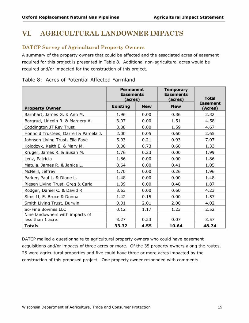
AGRICULTURAL LANDOWNER IMPACTS
DATCP Survey of Agricultural Property Owners
A summary of the property owners that could be affected and the associated acres of easement
required for this project is presented in Table 8. Additional non-agricultural acres would be
required and/or impacted for the construction of this project.
Table 8: Acres of Potential Affected Farmland
Property Owner
Permanent
Easements
(acres)
Temporary
Easements
(acres) Total
Easement
(Acres) Existing New New
Barnhart, James G. & Ann M. 1.96 0.00 0.36 2.32
Borgrud, Lincoln R. & Margery A. 3.07 0.00 1.51 4.58
Coddington JT Rev Trust 3.08 0.00 1.59 4.67
Honnold Trustees, Darrell & Pamela J. 2.00 0.05 0.60 2.65
Johnson Living Trust, Ella Faye 5.93 0.21 0.93 7.07
Kolodzyk, Keith E. & Mary M. 0.00 0.73 0.60 1.33
Kruger, James R. & Susan M. 1.76 0.23 0.00 1.99
Lenz, Patricia 1.86 0.00 0.00 1.86
Matula, James R. & Janice L. 0.64 0.00 0.41 1.05
McNeill, Jeffrey 1.70 0.00 0.26 1.96
Parker, Paul L. & Diane L. 1.48 0.00 0.00 1.48
Riesen Living Trust, Greg & Carla 1.39 0.00 0.48 1.87
Rodger, Daniel C. & David R. 3.63 0.00 0.60 4.23
Sims II, E. Bruce & Donna 1.42 0.15 0.00 1.57
Smith Living Trust, Durwin 0.01 2.01 2.00 4.02
So-Fine Bovines LLC 0.12 1.17 1.23 2.52
Nine landowners with impacts of
less than 1 acre. 3.27 0.23 0.07 3.57
Totals 33.32 4.55 10.64 48.74
DATCP mailed a questionnaire to agricultural property owners who could have easement
acquisitions and/or impacts of three acres or more. Of the 35 property owners along the routes,
25 were agricultural properties and five could have three or more acres impacted by the
construction of this proposed project. One property owner responded with comments.

Oxford Replacement Natural Gas Pipelines Agricultural Impact Statement
Wisconsin Department of Agriculture, Trade and Consumer Protection 20
Property Owner Comments
Farmland Owner: Lincoln R. and Margery A. Borgrud Proposed Acquisition: Temporary Easement: 1.51 acres / Permanent Easement: 3.10 acres
The Borgruds own 103 acres of land consisting of 93 acres enrolled in the Conservation Reserve
Program and 10 acres of wetland. There are no drainage tiles or conservation practices on this
property that would be affected by the project. The owners did not identify any concerns they
might have about the proposed project or its potential impacts on their property.
AMP and BMPs and the Role of the Agricultural Inspector
Wisconsin Gas will employ a construction manager and an environmental manager to provide
oversight and enforcement of permits, approvals, and the AMP and BMPs. Wisconsin Gas may
also retain one or more individuals designated as the project Agricultural Inspector. If retained,
the Agricultural Inspector will be thoroughly familiar with the project and pipeline construction
processes as well as issues regarding agricultural operations and soil conservation. DATCP
recommends that the project have at least one individual designated as the Agricultural Inspector
for this project and that he/she submit weekly reports during the construction of the project to
DATCP for review.
Contractors will be required to structure their construction activities to be consistent with the AMP
and the BMPs. Refer to Appendix E for the full text of these documents. Wisconsin Gas will work
with landowners to ascertain existing agricultural operations that may require special attention
during construction and restoration. Topics that are covered by the AMP and BMPs include
restoration of any damaged conservation practices, tiling, and fences.
Appraisal and Compensation
The acquisition of easements by utilities with eminent domain authority in Wisconsin is stipulated
under Wisconsin Statute § 32.06. Additional information about the appraisal process and
landowners rights can be found in a Wisconsin Department of Administration publication, “The
Rights of Landowners under Wisconsin Eminent Domain Law,” at the website:
http://doa.wi.gov/Documents/DEHCR/Relocation/WI_Eminent_Domain_Law32_06.pdf
Wisconsin Gas may conduct a market study to determine current area property values of affected
property. If the landowner signs an appraisal waiver form, the market study will be the basis for
the utility’s offer of compensation and no individual property appraisal will be conducted.
Wisconsin Gas may also offer additional compensation to landowners who choose to sign the
appraisal waiver form.
Landowners have the right to obtain an appraisal of their property under Wisconsin’s eminent
domain laws (Wis. Stat. §32.06). A jurisdictional offer will include an appraisal of the fair market
value for the easement and any anticipated damages to the property. The fair market value
means the price that a willing buyer would pay to a willing seller in the market. This will be
Oxford Replacement Natural Gas Pipelines Agricultural Impact Statement
Wisconsin Department of Agriculture, Trade and Consumer Protection 21
based on at least one full narrative appraisal for each property the utility intends to acquire. The
appraisal must be presented to the landowner.
Additionally, landowners have the right to obtain their own appraisal of their property. They will
be compensated for the cost of this appraisal by the utility if the following conditions are met:
The appraisal must be submitted to the utility or its designated real estate contractor
within 60 days after the landowner receives the initial utility appraisal.
The appraisal fee must be reasonable.
The appraisal must be a full, narrative appraisal
The appraisal must be completed by a qualified appraiser.
The amount of compensation for the easement is established during the negotiation process
between the utility and the individual landowner. Landowners may also attempt to negotiate
additional stipulations from the utility and additional payments.
The utility is required to provide landowners with information about their rights in this process
before negotiations begin. Wis. Stat. § 32.035(4)(d) additionally requires that the utility not
negotiate with a landowner or make a jurisdictional offer until 30 days after the AIS is published.
Additional information about the appraisal process and landowners rights can be found on the
DOA website at: http://doa.wi.gov/Divisions/Energy-Housing-and-Community-
Resources/Relocation-Assistance.
Landowners should keep in mind that any easement they sign with a utility is an individual
contract. The easement contract is binding to the landowner and any future owners of the land,
until the contract is dissolved. When considering whether or not to sign an easement,
landowners should examine the language carefully and verify that it contains all agreed-to terms.
Landowners should be familiar with the company’s project-specific AMP and BMPs (Appendix E)
so as to determine if additional conditions should be negotiated with the utility. Though they can
choose to waive any or all of the practices and procedures described in the AMP and BMPs,
DATCP recommends to only do so with careful consideration. Landowners may want to seek legal
advice if they have any questions about this process, and should make sure that any attorneys
hired have expertise and experience in eminent domain law and procedures. More reference
information can be found in Appendix B.

Oxford Replacement Natural Gas Pipelines Agricultural Impact Statement
Wisconsin Department of Agriculture, Trade and Consumer Protection 22
CONSTRUCTION PROCESS
If the project is approved by the PSC, construction on the gas pipeline will likely begin after the
utility has secured all necessary permits and ROW easements. Typical natural gas pipeline
construction sequence proceeds in the manner of an outdoor assembly line; comprised of specific
activities that make up the linear construction sequence. These operations include surveying and
staking the ROW, clearing and grubbing (digging up roots and stumps), grading, pipe stringing,
welding and bending, trenching, lowering-in, backfilling, re-grading, cleanup, hydrostatic testing,
and restoration (Figure 4). While most of this project would use open trench construction,
horizontal directional drilling (HDD) will be used in some locations to avoid impacts to features
such as roads, driveways, and natural resources.
Typical construction equipment used on pipeline projects includes: dozers, graders, excavators,
trenchers, dump trucks, backhoes, side booms, ATV’s, road bore rigs, horizontal directional drill
rigs, pickup trucks, rock trenchers, vacuum excavators, rippers, tillers, rock picking machines,
welding rigs and trucks, and x-ray trucks.
Surveying and Staking
The first construction step involves surveying and staking the pipeline centerline, construction
ROW limits, temporary workspace areas, and known underground facilities that cross or parallel
the proposed pipeline. Construction activities and equipment travel requires the use of
temporary work space in addition to the permanent easement.
Access roads to the pipeline ROW are typically along existing ROWs such as public roads and
farm roads. Additional temporary access roads may be necessary, and some of these may cross
agricultural lands. Temporary work space needed for access roads on private lands will be
negotiated with the landowner. Construction of these roads will follow practices detailed in the
utility’s AMP and BMPs including where appropriate, soil segregation, proper maintenance of
existing surface drainage patterns, and restoration of the land. If the property owner approves,
access roads will be left in place.
Clearing, Grubbing, and Grading
The construction ROW (easement and areas secured for temporary work space) is cleared,
grubbed, and graded to provide a level area for pipe-laying operations and the transport of
construction equipment. Clearing involves the removal of all trees and brush from the work area.
Grubbing, the removal of stumps and roots, occurs over the area where the trench will be
excavated. Non-woody vegetation is removed by mowing. However, crops such as small grains
with a limited amount of biomass may be left in place to minimize soil erosion. A fence crew
operates with the clearing crew to cut and brace existing fencing and install temporary gates
along the ROW. This crew also installs necessary fencing along identified sensitive areas as
required by agencies and along pastures that contain livestock.

Oxford Replacement Natural Gas Pipelines Agricultural Impact Statement
Wisconsin Department of Agriculture, Trade and Consumer Protection 23
Figure 4: Typical Pipeline Construction Cross-Section on Agricultural Land
Source: We Energies

Oxford Replacement Natural Gas Pipelines Agricultural Impact Statement
Wisconsin Department of Agriculture, Trade and Consumer Protection 24
The utility will work with affected landowners when the cutting of merchantable timber on their
property is necessary for construction of the pipeline. Timber may be cut and left along the edge
of the ROW for the landowner’s use. If the landowner does not want to retain ownership of the
material, it will be properly disposed. The disposal of trees, brush, and stumps may include
burning, burying, or chipping at a landowner-approved location or removal to another authorized
location.
Vegetation from wild black cherry and black walnut trees can be toxic to livestock. All debris
from these trees are to be removed from actively pastured areas to prevent its contact with
livestock. This material will not be stockpiled on-site.
The utility strips the topsoil (typically the top 12 inches) from the full width of the ROW in
agricultural areas. The topsoil is stockpiled along the edge of the easement to minimize damage
to the productivity of the topsoil. In some locations, maintaining pre-construction soil
productivity requires that the subsoil be segregated not only from the topsoil but also from the
underlying parent material. This is known as three-lift soil managing.
Erosion control methods and materials vary depending on the specific construction activities, time
of year, and site soil and slope conditions at the time of construction. A general description of
construction phases will be outlined in the utility’s Erosion Control Plan and the project-specific
AMP and BMPs. These documents include details about clearing and grubbing (digging up roots
and stumps), pipe and associated facility installation, and restoration.
Pipe Stringing
After clearing, grubbing, and grading, sections of pipe are transported by truck from pipe storage
areas to the construction ROW and positioned along the pipeline route. This is called pipe
stringing. Pipe stringing can be conducted either before or after trenching.
Bending and Welding
After pipe stringing, the sections of pipe are bent, as necessary, to fit the contours of the terrain.
The pipe is then placed on temporary supports along the edge of the trench, aligned, and welded
together. A qualified inspector visually and radiographically inspects the completed welds.
Following inspection, a coating is field-applied to each weld joint. An external coating, applied at
the mill protects the rest of the pipe. This pre-applied coating is also inspected and repaired as
necessary.
Trenching
Open trenching is the primary method for new gas pipeline construction. Alternatively, in some
locations, the utility will use HDD to avoid impacts to features such as roads, driveways, and
natural resources. HDD is discussed in more detail later in this section. Trenches are typically
excavated using a backhoe, or in some cases a trackhoe, or a trenching machine. Topsoil and
Oxford Replacement Natural Gas Pipelines Agricultural Impact Statement
Wisconsin Department of Agriculture, Trade and Consumer Protection 25
subsoil excavated during trenching of agricultural land is segregated and temporarily stored
within the construction ROW for use during restoration. Any material not suitable for backfill, or
in excess, is hauled to a suitable location. Proper erosion control practices are employed to
minimize erosion during trenching and construction activities. The trench bottom is inspected to
ensure it is free of rock and debris. If required, sand or soil bedding material is placed in the
trench bottom. Any necessary dewatering of the trench is done in accordance with applicable
permits and regulations.
Lowering-In
The pipeline is then lowered into the trench using side-boom tractors. A final inspection ensures
the pipeline is properly placed on the trench bottom, that all bends conform to trench alignment,
and that the pipe coating is not damaged.
Trench Breakers and Tile Repairs
Upon completion of lowering-in activities, trench breakers (plugs) are installed as needed in
sloped areas to prevent subsurface water from moving along the pipe. Permanent tile repairs are
also completed during this phase.
Backfilling
After the pipeline is installed in the trench, the trench is first backfilled with the subsoils and then
the topsoil is redistributed over the trench and working area. To minimize the potential for soil
compaction in agricultural areas, certain construction techniques may be suspended due to wet
weather conditions or post-construction soil decompaction techniques may be required to return
the soil to productivity.
Rocks removed from the trench but not suitable for backfill are properly disposed of. Rock
content of the ROW is managed so that the size and distribution are similar to the adjacent land.
The ROW is graded as near as practicable to preconstruction contours, except as needed for soil
stability purposes and the installation of erosion control measures.
Horizontal Directional Drilling (HDD) and Jack and Boring
Both jack and boring and HDD construction are alternatives to open trench construction.
Jack and bore may be used to cross under roadways or railways with minimal disruption to
traffic. Typically the construction area is first stripped of topsoil that is set aside. Bore pits are
then excavated on each side of the obstruction. The bore pits are typically 20 feet by 30 feet and
6 to 12 feet deep. Any groundwater is pumped into a dewatering structure. The auger boring
machine and a casing pipe are jacked under the obstruction while the earth is removed by an
auger inside a casing pipe. The new carrier pipe is attached to the casing pipe and is either
pushed or pulled under the road or railway. After the new carrier pipe is installed and tied into
the rest of the pipeline, the bore pits are backfilled and restored.

Oxford Replacement Natural Gas Pipelines Agricultural Impact Statement
Wisconsin Department of Agriculture, Trade and Consumer Protection 26
HDD is often used to avoid disturbance to environmentally sensitive areas such as wetlands and
waterways. HDD construction through wooded areas requires fewer trees to be removed than for
open trench construction. An entry and exit bore pit are typically excavated on either side of the
feature to be avoided. Typically, additional ROW is needed to accommodate these entry and exit
bore pits. First, a drill machine is set up and a small diameter pilot hole is drilled under the
obstacle. The pilot hole is then enlarged using reaming tools. During this process, drilling mud
composed of clean water, bentonite clay, and synthetic polymers are pumped into the hole to
lubricate the reaming tool, remove soil cuttings, and maintain the integrity of the hole. When the
hole is the appropriate size, the welded pipe is pulled through the hole. Used drilling mud is
taken to an approved upland area or disposed of in accordance with applicable permits and
regulations. Exit and entrance bore pits are restored.
Cleanup and Initial Restoration
Following the completion of construction activities, the area is restored to preconstruction
conditions. Surface grading is done to reestablish natural contours. Disturbed areas are
revegetated to be compatible with preconstruction conditions and adjacent vegetation patterns.
Where necessary, soil compaction is alleviated and any segregated topsoil replaced. Additional
detail and information about soil compaction and restoration is included in Section VIII: Potential
Adverse Impacts of Pipeline Construction on Agriculture. Trash and debris are removed and
disposed of in approved areas in accordance with federal, state, and local regulations.
Fences cut or removed during construction are repaired or replaced. Pipeline markers are
installed along the length of the pipeline in accordance with Department of Transportation (DOT)
specifications. If drain tiles were damaged by construction activities, they are repaired.
Hydrostatic Testing
The completed pipeline is then hydrostatically tested and caliper-pigged prior to service. A pig is
a mechanical device that is sent through the pipeline to perform tests on the pipeline. After
backfilling is completed, sections of the pipeline are filled with water and tested to pressure levels
greater than the maximum design operating pressure of the pipeline in accordance with DOT
standards. These procedures are repeated along the entire length of the new pipeline. After
completion of testing, the test water is disposed of in accordance with permit requirements.
Final Restoration
Revegetation is completed in areas where vegetation was disturbed by construction activities.
Typically active or rotated croplands are not seeded unless specifically requested to do so in
writing by the landowner or land management agency.
Erosion and sediment controls are implemented as needed and maintained until final restoration
and stabilization are achieved.

Oxford Replacement Natural Gas Pipelines Agricultural Impact Statement
Wisconsin Department of Agriculture, Trade and Consumer Protection 27
POTENTIAL ADVERSE IMPACTS OF PIPELINE
CONSTRUCTION ON AGRICULTURE
Agricultural operations and productivity can be adversely affected by pipeline construction.
These impacts include but are not limited to:
Interference with farm operations in the ROW and adjacent areas
Soil erosion and runoff
Interruption of or damage to irrigation systems
Alteration of surface and subsurface drainage systems
Impacts to grazing areas, row crops, and existing fencing
Flooding due to dewatering activities during construction
After construction is completed, some impacts may affect agricultural productivity years
afterwards, not only in the ROW but in the adjacent fields as well. These long-term potential
impacts include but are not limited to:
Topsoil inversion and mixing of the subsoil with spoil materials
Soil subsidence
Erosion
Deep compaction of subsoils
Ponding and drainage seeps from altered surface and subsurface drainage profiles
Inadequate restoration resulting in increased rock content or alteration to the original
land contours
Topsoil Mixing
Potential Adverse Impact
Good agricultural topsoil is an invaluable resource that should be preserved. Mixing of topsoil
with the underlying subsoil and/or parent material will reduce tilth, organic matter content and
cation exchange capacity, and alter soil structure and distribution of particle sizes (particularly
water stable aggregates). The mixing of soil layers can also increase the number of rocks and
increase the concentrations of harmful salts near the surface. Rocks larger than three inches can
damage farm equipment and reduce soil productivity. Once mixed, full restoration may require
transporting new topsoil of similar quality from an off-site location. This will add costs to the
project and may still not fully return the agricultural field to pre-construction productivity.
Topsoil mixing can occur under wet or dry conditions, during the grading and re-grading of the
pipeline ROW. Significant long-term agricultural productivity impacts can occur as a result of soil
mixing if deep ruts are created during construction and the topsoil layer is shallow. To avoid
these types of impacts, topsoil is typically stripped to a depth of at least 12 inches.

Oxford Replacement Natural Gas Pipelines Agricultural Impact Statement
Wisconsin Department of Agriculture, Trade and Consumer Protection 28
Soil mixing is a greater danger when soils are wet. The moisture and precipitation pattern
expected during construction must be taken into account in planning adequate mitigation
measures to protect topsoil from mixing. In some soils, one inch of summer rainfall over five out
of ten days can cause significant rutting with normal construction equipment traffic.
Measures to Avoid Topsoil Mixing/Inversion
To prevent the mixing of topsoils with subsoil layers, the topsoil is stripped from the full width of
the ROW to a depth of 12 inches across agricultural lands (Appendix E, AMP Section a and BMP
02). This is done prior to grading and any construction activities. Topsoil does not need to be
removed from the topsoil storage area on the edge of the working side of the trench or areas
where construction mats are laid on the surface for material storage and equipment travel. The
stripped topsoil is then stored separately from the subsoil material until construction is complete
and the topsoil can be replaced during restoration of the ROW. With the topsoil removed, work
may continue under wetter conditions; however subsoils may still be at risk for compaction and
rutting. If compaction occurs or is suspected, subsoils should be de-compacted during the
restoration process.
Fertile Subsoil Mixing with Underlying Soils (Three-Lift Soil Handling)
Potential Adverse Impact
Long-term crop productivity losses may result from mixing lower soil layers of glacial till/outwash
or sandy soil with upper layers of better quality subsoils. The subsoil layer in many parts of
Wisconsin is often of relatively high quality. Estimates for yield loss may be as significant
immediately after construction for areas where poorer quality subsoils are mixed with better
quality upper soil horizons.
Measures to Avoid Mixing of Fertile Subsoils Mixed with Underlying Parent Material
To avoid mixing the fertile subsoil with underlying gravelly material, three-lift soil handling can be
used to greatly mitigate construction impacts to agricultural soils. Details about three-lift soil
handling for this project can be found in Section V of this report, under “Three-Lift Soil Handling.”
For this method, the subsoil is not only segregated from the topsoil but also from the underlying
soil horizons. Three separate storage piles are required: one for the topsoil to a depth of 12
inches; a second for the subsoil to its depth of up about to 2 or 3 feet; and a third for the
underlying soil horizons. All three soil layers are stored separately for reuse during backfilling of
the trench and restoration. In order for this method to be of value, there must be a significant
difference between the upper subsoil layer and the lower subsoil layer or parent material.
Candidate soils are identified through desktop soil analysis and verified by subsequent on-site
sampling. This type of soil segregation would only be used over the trench and through lands
that are and will be returned to crop and pasture use (Appendix E, BMP 09).

Oxford Replacement Natural Gas Pipelines Agricultural Impact Statement
Wisconsin Department of Agriculture, Trade and Consumer Protection 29
Increased Rock Content of Soil
Potential Adverse Impacts
Large stones at the surface can damage farm machinery and lead to added costs to landowners
for removal. Many subsoil layers have a greater rock content than the topsoil. Trench
excavations may bring up lower soil horizons with rocky subsoil, which might be mixed with
upper soil layers. Even where the three-lift method is used, additional rocks may be spread
through the subsoil layer during backfilling.
Pipeline companies typically pad the area around the pipe with sand or stone-free subsoil to avoid
damage to the pipe. Due to the subsurface soil volume displaced by the pipe and by the padded
stone-free area, the restored upper subsoil profile may end up containing a higher rock content
than was present before excavation. Through frost heave dynamics, these rocks may eventually
end up near the soil surface.
Mitigation Measures
To avoid increasing the rock content of the subsoil, Wisconsin Gas will ensure that the size,
density, and distribution of rock in the restored construction work areas will be similar to the
adjacent areas not disturbed by construction. Excess rocks should not be spread across the
ROW, added to the topsoil pile, or added to other farm fields.
Soil Compaction
Potential Adverse Impact
Compaction of subsoil and topsoil is a major adverse impact that can result from pipeline
construction. Compaction reduces the uptake of water and nutrients by crops, restricts rooting
depth, decreases soil temperature, increases the proportion of water-filled pore space at field
moisture capacity, decreases the rate of decomposition of organic matter, decreases pore size
and water infiltration, and increases surface runoff. The greater the depth at which soil
compaction occurs, the more persistent it is.
Yield loss caused by soil compaction may range between 10 and 50 percent for a variety of crops
(Wolkowski, R. & Lowery, B., (2008), Soil Compaction: Causes, Concerns, and Cures, University
of Wisconsin Extension, publication A3367). The magnitude of yield loss is dependent on a
number of factors including, soil type, degree of compaction, and water availability. Compaction
is most evident when the crop is under additional stress such as drought or excessively wet
conditions.
The factors that influence whether a soil becomes compacted include the weight of the
construction equipment traveling over the soil, soil moisture, and soil texture. As axle load
increases, the depth of compaction can increase. When traffic loads are relatively lightweight,
less than 10 tons per axle, the soil generally does not compact below the 8-10 inch range.

Oxford Replacement Natural Gas Pipelines Agricultural Impact Statement
Wisconsin Department of Agriculture, Trade and Consumer Protection 30
Compaction at this depth can usually be decompacted with typical farm tillage equipment.
Heavier construction equipment can compact soils to a depth that cannot be removed by
conventional tillage. Wet soils can also increase the risk for compaction. Sometimes, the plow
layer may appear dry, but the subsoil can still be saturated resulting in the potential for
significant compaction during construction. Also, soil texture may be a good indicator of
potentially sensitive soils. Fine soils, such as clay or silty clay loams have a greater risk of
becoming compacted.
Soil Restoration: Removing Compaction in Subsoil and Topsoil
Pipeline construction can cause long-term damage to agricultural productivity from deep soil
compaction if proper construction methods are not implemented or proper decompaction is not
performed. However, with the proper techniques, timing, and equipment, there are few subsoils
that cannot be adequately decompacted.
Prevention of rutting and compaction is easier than restoring the soil structure after it has been
damaged. The most effective method to reduce compaction and rutting in construction ROWs is
to avoid the use of heavy construction equipment when the soils are wet.
After construction is completed, the ROW will be compacted to some degree. Deep tillage
equipment are typically used on the exposed subsoil of the construction ROW, after the trench
has been backfilled and time has been allowed for trench settling.
One common option for deep ripping is an industrial V-ripper, which should have 4 to 5 heavy-
duty shanks, spaced 30 to 36 inches apart and be pulled with 40 to 50 horsepower per shank. It
is recommended to use this with an articulated, 4-wheel drive tractor with the bulk of the weight
in front. Such rippers are often not readily available to typical farm operators. Other types of
equipment such as chisel plows or paraplows may also be effective under some conditions.
Multiple passes with the deep decompaction device are essential over the compacted subsoil in
the ROW until sampled penetrometer readings in the ROW match those in adjoining fields that
were not disturbed by construction. The typical depth of ripping is 18 to 24 inches below the
exposed subsoil. Multiple straight and zigzag patterns of ripping need to be used on different
passes. The type of equipment used and the depth of rip may be adjusted as appropriate for
different soil types or for a deeply and severely compacted soil.
In lacustrine soils with intensive tile drain systems, deep ripping may be limited to the top 6 to 8
inches of the subsoil layer because soil compaction from pipeline construction is usually
undetectable below 8 inches and deeper ripping could destroy the load-bearing capacity of the
subsoil. However, the presence of tile lines is no reason to avoid completing the deep ripping
phase of the soil restoration process. Any damage to tiles during the deep ripping process must
be repaired/replaced by the utility at the utility’s expense. Deep ripping and other subsequent

Oxford Replacement Natural Gas Pipelines Agricultural Impact Statement
Wisconsin Department of Agriculture, Trade and Consumer Protection 31
restoration steps must only be done during low soil moisture conditions to prevent irreparable
damage to soils from mixing or additional compaction.
Following decompaction, penetrometer measurements are taken as per a sampling protocol to
ensure proper decompaction has occurred at representative sites throughout the topsoil and
subsoil profile. Moisture conditions should be comparable on and off the construction ROW and
throughout the soil horizon at the time of sampling since the same bulk density will result in a
much lower penetrometer resistance reading when the soil is wet as opposed to when it is dry.
Once effective deep decompaction of subsoil has been accomplished as indicated by
penetrometer readings, rocks have been removed and topsoil replaced, a final subsoil shattering
may be necessary to correct the compaction caused by the heavy decompaction equipment. This
is done using an angled 3- or 4-leg tool bar, with leg spacing set no greater than 2 feet.
Equipment commonly used for this includes a four-legged paratill or paraplow with the depth
wheels disengaged to allow for maximum adjustment of depth of penetration. The angled legs
are pulled slowly at an 18-inch depth (up to a maximum of 24 inches) using 50 horsepower per
leg by a 4-wheel drive articulated tractor with the bulk of the weight in front traveling at a rate of
2.5 to 3 mph. This must be done only in conditions of low moisture to prevent damage to the soil
profile and sloughing or mixing. Disking should not be used for subsoil shattering because it can
mix and re-compact the subsoil and topsoil.
In most cases, DATCP does not recommend the delegation of decompaction to farm operators.
Farm operators generally lack the proper equipment to correctly restore productivity after
pipeline construction. The necessary scope and depth for successful decompaction of agricultural
lands typically exceeds standard farming equipment and practices.
Drainage
Potential Adverse Impacts
Proper field drainage is vital to a successful farm operation. Pipeline construction can
permanently disrupt improvements such as drainage tiles, grassed waterways, and drainage
ditches, which regulate the flow of water on farm fields. Compaction can also alter the soil
profile, and cause ponding or seeps, where none existed prior to construction. The pipeline may
exacerbate existing drainage problems in fields by increasing surface flows within the
construction area and in adjacent fields.
If drainage is impaired, water can settle in fields and cause substantial damage such as retarding
the growth of crops and other vegetation, concentrating mineral salts, flooding farm buildings, or
causing hoof rot and other diseases that affect livestock.

Oxford Replacement Natural Gas Pipelines Agricultural Impact Statement
Wisconsin Department of Agriculture, Trade and Consumer Protection 32
It may take several years for these problems to become apparent, or even longer if there is a dry
year. It is also possible for pipeline construction to interfere with future plans for drainage
systems in a field.
Mitigation Measures
DATCP recommends that landowners work with the utility about the existence and location of
drainage systems or planned drainage systems that could be affected. Field conditions should be
documented by the landowner prior to the start of construction so it can be compared with post-
construction conditions.
The utility should note and monitor the location of significant seeps along the trench walls during
the open construction phase of the project. Temporary ditch plugs and permanent trench
breakers can be used to help deter the pipeline corridor from acting as a channel for underground
water flows.
The AMP and BMP 04 (Appendix E) requires that the excavated pipeline trench be a minimum of
12 inches from the drainage tile, where practicable. All damaged tiles will be permanently
repaired prior to backfilling. Repaired tiles on or adjacent to the ROW must be equivalent to its
prior condition. Local tile contractors should be used wherever possible.
After construction is completed, landowners and the utility should carefully monitor for the
emergence of drainage problems. Once these problems are observed, the landowner should
notify the utility and the utility should take remediation steps as soon as possible.
Where construction activities have altered the natural stratification of the soils resulting in new
wet areas, DATCP recommends Wisconsin Gas work with the landowner to determine the means
to return the agricultural land either in the ROW or on adjoining lands to pre-construction
function. New drainage tiles, regrading, or additional fill may be required to correct the problems
that arise after construction is completed.
Trench Dewatering
Potential Adverse Impacts
Before lowering the pipe into the trench, dewatering of the trench may be necessary so that the
bottom of the trench can be inspected for rocks. Any combination of weather, topography and/or
hydric soils (i.e. land with a shallow water table) can result in conditions of wet trenching. Extra
care must be taken when wet trenching to avoid mixing, compacting, and erosion of the subsoil.
Trench dewatering is typically done in such cases. Improper trench dewatering can result in soil
erosion; sedimentation and deposition of gravel, sand, or silt onto adjacent agricultural lands;
and inundation of crops.

Oxford Replacement Natural Gas Pipelines Agricultural Impact Statement
Wisconsin Department of Agriculture, Trade and Consumer Protection 33
Mitigation Measures
The BMPs (Appendix E, BMP 05: Trench Dewatering) requires Wisconsin Gas to identify low areas
and hydric soils that are likely to collect water during construction, as well as suitable areas for
the discharge of water accumulated within the pipe trench or other excavated areas. The utility
must ensure that work is structured to minimize the accumulation of water within the trench and
create discharge locations that are in compliance with current drainage laws, local ordinances,
DNR permit conditions, and the provisions of the Clean Water Act. Discharge locations must be
well-vegetated areas that prevent the water from returning to the ROW; be as far from backfilling
activities as possible; and not deposit gravel or sediment onto fields, pastures, or watercourses.
If deposition of trench water onto cropland is unavoidable, crops should not be inundated for
more than 24 hours. Crops inundated for more than 24 hours may incur severe damage.
Discharge of water from non-organic farms or from hydrostatic testing should never be allowed to
flow onto organic farm operations.
Silt or sediment extraction from the trench is required to be minimized by preventing the intake
from touching the bottom or sides of the trench, and by ensuring that the intake is supported by
a flotation device. Dewatering will be monitored and stopped whenever necessary to correct
conditions and practices inconsistent with BMP 05. When construction in hydric soils creates wet
trenching and dewatering activities that cause unavoidable damage, Wisconsin Gas will
reasonably compensate the landowner for damages and restore the land and crops to pre-
construction conditions.
Erosion and Conservation Practices
Potential Adverse Impacts
Both topsoil and subsoil along the project routes are valuable resources. Construction activities
can destabilize soil horizons and cause top soil to erode and potentially migrate off of the ROW.
During wet conditions, risks to soil from erosion are increased. However, in parcels with a
shallow water table, wet conditions may be the normal soil condition as exposed soils form rills
and the soil travels downslope. In these areas wet trenching may be necessary. Areas with
steeper slopes can be subject to greater soil loss from erosion by water. Silt and very fine sand,
and certain clay textured soils tend to be more susceptible to erosion. Trench dewatering can
also result in flooding, erosion, and sedimentation on farm fields off the ROW unless appropriate
measures are applied.
Significant erosion can have an adverse effect on long-term productivity of agricultural lands.
Where a pipeline ROW runs up and down gently sloping soils, the collection of surface runoff in
the tracks left by construction equipment can erode significant amounts of soil in fields.

Oxford Replacement Natural Gas Pipelines Agricultural Impact Statement
Wisconsin Department of Agriculture, Trade and Consumer Protection 34
Many agricultural fields have existing erosion control practices such as diversion terraces, grassed
or lined waterways, outlet ditches, water and sediment control basins, vegetated filter strips, etc.
These can be damaged by construction activities.
Soil erosion can affect crop yields through the loss of natural nutrients and applied fertilizers.
Seeds and plants can be disturbed or completely removed from the eroded site. Organic matter,
manure, and crop residue can be transported off the field through erosion. Pesticides can also be
carried off the site with eroded soil.
Mitigation Measures
To avoid erosion, construction and restoration should not proceed if conditions are excessively
wet. The Wisconsin Gas AMP, Section f (Appendix E), requires that the construction contractor
meet or exceed DNR standards for erosion control on construction sites. These standards are
described on the DNR’s website at: http://dnr.wi.gov/topic/stormwater/standards/index.html.
Erosion control practices must be carefully followed to minimize construction-related impacts.
The AMP (Appendix E) allows the Agricultural Inspector to temporarily halt construction or
restoration activities when work activities do not appear to meet the AMP requirements. This
authority may be used when the soil conditions are unfavorable due to weather conditions.
Existing erosion control practices such as diversion terraces, grassed or lined waterways, outlet
ditches, water and sediment control basins, vegetated filter strips, etc. damaged by construction
activities must be restored to pre-construction condition.
Temporary erosion controls must be properly maintained on agricultural lands on a daily basis
throughout construction and restoration. Whenever necessary, they must be reinstalled until
permanent erosion controls are installed or restoration is completed. The details of erosion
controls are described in AMP Sections f and i, and in BMP 03 (Appendix E).
The best method to control erosion is the growth of a vegetative cover. As soon as practicable
the land should be returned to cropland or seeded with the appropriate species mix.
The utility must structure work in a manner consistent with the requirements of the AMP and
BMPs and maintain an adequate supply of approved erosion control materials on hand.
Crop Rotation and Dairy Operations
Potential Adverse Impacts
A common dairy rotation may include 2 to 3 years of field corn, followed by soybeans, and then 3
years of alfalfa. Construction activities across fields may affect the yield and/or quality of the
alfalfa crop that the farming operation needs to feed its herd. If construction activities cause a
delay in alfalfa seeding, it may cause a shortage of alfalfa forage or the field may contain an
increase percentage of grass. Some operators may choose to alter their crop rotation schedule

Oxford Replacement Natural Gas Pipelines Agricultural Impact Statement
Wisconsin Department of Agriculture, Trade and Consumer Protection 35
and plant extra years of row crops to avoid the likelihood of an alfalfa crop that doesn’t meet the
operation’s quantity or quality forage needs. If any of these occur, the operator will be
negatively impacted due to a shortage of alfalfa forage and the operator would need to adjust the
herd’s diet by doing any or all of the following: buy haylage or hay, obtain more corn silage,
and/or provide protein supplements such as soybean oil meal. All these activities would increase
costs to the dairy operator.
Mitigation Measures
Dairy operators need to know the construction schedule well in advance in order to make
adjustments to their crop rotation schedule. Due to the high cost of seeding alfalfa, some
operators may decide to plant a row crop during the year of construction and maybe even the
year following construction to have an additional opportunity for tillage to further decompact the
soils. Other operators may choose to keep a field in alfalfa but may have decreased quality or
quantity of yields from construction impacts. Fertilization (top-dress) of the forage field with
potassium (K20) may enhance alfalfa plant density. With advance knowledge of the construction
schedule, dairy operators can determine how best to provide forage for the herd and the
associated costs for these adjustments.
The utility should provide dairy operations with as much advance information as possible about
the construction schedule on individual properties and compensate the landowner for any
increased costs associated with construction impacts to forage requirements.
Temporary Access Roads
Potential Adverse Impacts
Temporary access roads may need to be created during the construction process to allow
personnel and equipment to access the construction corridor. Where possible, existing public or
private roads are used. However, in some locations these are not available or suitable.
Temporary access roads may cross agricultural fields. The potential negative effects of building
access roads across agricultural lands include the potential mixing of topsoil with subsoil, soil
compaction, erosion, and interference with existing drainage, irrigation, and farming operations.
Any of these impacts can result in the loss of agricultural productivity on affected soils after
construction is completed.
Mitigation Measures
The utility will use existing public roads and farm roads to access the ROW whenever possible.
The utility must consult with landowners before siting temporary access roads on their property.
(Appendix E, AMP, Section 10b) Where new access roads are constructed on agricultural land,
the utility will strip the topsoil and temporarily stockpile it. Access roads should be designed to
allow proper drainage and minimize soil erosion. Geotextile construction fabric may be placed

Oxford Replacement Natural Gas Pipelines Agricultural Impact Statement
Wisconsin Department of Agriculture, Trade and Consumer Protection 36
below any imported rock used to build the road, in order to protect the subsoil. If desired by the
landowner, temporary roads will be left in place after construction. If access roads are removed,
adequate soil restoration practices should be used to return the agricultural field to pre-
construction function. Any disturbance to drainage tiles or drainage patterns should be
remediated by the utility or its contractors. During the restoration phase, temporary and existing
access roads should be restored to preconstruction conditions. If additional top soil is necessary
to restore the farmland, top soil should be of similar quality to adjacent soils. All construction
temporary access roads will be removed unless there is an agreement in writing between the
landowner and the utility for them to remain.
Trees and Other Woody Vegetation
Adverse Impacts
All trees will be removed from the full width of the ROW (temporary and permanent ROW) prior
to the start of construction. Agricultural property owners have trees on their property for many
uses. They may have:
a woodlot for income, firewood, or recreational use
tree crops (nurseries, orchards, Christmas tree farms)
a fencerow used as a windbreak to reduce erosion
trees to shade livestock
trees planted as a visual and/or sound barrier from a highway or other land uses
ornamental, shade, fruit and nut trees for personal use, or other landscaping around
the residence and other buildings for aesthetic purposes
Typically, tree stumps are only excavated and removed from the trench area. Stumps in other
parts of the ROW are usually cut at or near ground level.
Both the existence of a woodlot or tree crops provide financial benefit to the landowner.
Windbreaks in the form of a single row of trees may protect for a distance downwind for
approximately 10 to 12 times the height of the windbreak. Therefore, taller trees in a windbreak
will protect a larger area of cropland than shorter trees. Tree lines can serve as a herbicide
barrier between organic farm parcels and farm operations not under organic management.
Removal of this barrier may allow herbicide drift to affect an organic farm operation. Shade trees
in pastures benefit livestock. Heat above 75 degrees Fahrenheit can negatively affect livestock
by inhibiting feed intake, which can result in lower milk production in dairy animals and lower
weight gain in meat animals. Planted trees can have sentimental value or add aesthetic
enjoyment to the property. Removal of any trees from a property can decrease overall market
value of the property.
Trees may be permitted to regrow or be replanted in the temporary easement areas. However,
the permanent easement (between 20 to 50 feet of ROW width) must remain clear of trees for

Oxford Replacement Natural Gas Pipelines Agricultural Impact Statement
Wisconsin Department of Agriculture, Trade and Consumer Protection 37
pipeline safety and access purposes. The utility may elect to minimize the “tree-free” corridor to
a width of 20 feet so that impacts to tree crops are minimized.
Where the ROW crosses through wooded areas, the landowners may choose to keep the cut
timber, which will be cut and stacked at the edge of the construction corridor. If they decline,
the cut wood will be removed from the site.
Some parts of trees contain compounds that are toxic if eaten by livestock. Cornell University
identifies these potential risks to livestock
(http://poisonousplants.ansci.cornell.edu/php/plants.php?action=display&ispecies=cattle):
Seeds, leaves, and bark from wild cherries, black cherry, bitter cherry, choke cherry,
and pin cherry trees (Prunus spp.) to all grazing animals
Acorns and young leaves from oak trees (Quercus spp.) for all grazing animals
Bark, leaves, and seeds from a black locus trees (Robinia pseudoacacia) to horses and
cattle
Leaves, twigs, roots, unripe fruit from elderberry bushes (Sambucus canadensis) to
cattle and goats
Fruit from horse chestnut, buckeye trees (Aesculus spp.) to cattle and goats
Needles and young shoots from Ponderosa pine (Pinus ponderosa) to cattle
Chipped wood from these trees or other tree parts may present a danger to livestock when the
ROW is returned to pasture after construction is completed.
The utility will dispose of any trees or brush that the landowner doesn’t want by burying, burning,
or removing the woody vegetation off-site. Refer to the AMP, Section c (Appendix E) for
additional details about vegetation removal.
Mitigation Measures
Landowners are compensated for the loss of trees and may also be compensated for the future
loss of tree crop within the permanent easement. If these properties are removed from
agricultural use in the future, the utility may decide to remove all trees within the 50 foot
permanent easement corridor, as those trees would no longer be an agricultural crop. Before an
easement is signed, landowners should determine from the utility where trees will and will not be
permitted to re-grow within the ROW. The utility should consult with landowners before
disposing of any trees or stumps that need to be removed from the pipeline ROW.
Additionally, DNR guidelines should be strictly adhered to for preventing the spread of exotic
invasive plant species and diseases such as oak wilt and Heterobasidion root disease.
Where trees serve an agricultural function such as livestock shade or windbreaks, or if they
provide an aesthetic value, landowners should be adequately compensated for the full loss of the

Oxford Replacement Natural Gas Pipelines Agricultural Impact Statement
Wisconsin Department of Agriculture, Trade and Consumer Protection 38
function of the trees. An appraiser who has experience and expertise in valuing trees should be
consulted to ensure that landowners receive fair compensation that includes all of the value those
trees provide.
If some of the trees might be considered toxic to livestock and the ROW would be returned to
pasture use, the utility should work with the landowner to identify potential risks. If the
landowners has specific livestock concerns, trees such as wild cherry and black walnut must not
be stockpiled or disposed so that the wood or wood parts could be accessible to livestock.
Irrigation
Potential Adverse Impacts
Pipeline construction can interfere with the operation of field irrigation systems. Crops outside of
the proposed pipeline ROW could also be negatively affected when irrigation is interrupted.
Mitigation Measures
The utility has the right to temporarily disrupt irrigation systems that intersect the pipeline during
construction. However, the landowner must be notified beforehand and establish a mutually
acceptable amount of time that the system will be taken out-of-service. The maximum period of
time that irrigation systems can be taken out-of-service without reducing yields on field corn is 5
to 7 days during the period from silking - tasseling to the finished crop. Earlier delays in meeting
irrigation requirements may result in smaller plants, but should not reduce grain production
significantly. Vegetable crops will have a shorter period between irrigations.
DATCP recommends that all irrigators along the pipeline route document irrigation information for
their fields, including amount of water and frequency of irrigation; and weather conditions such
as rainfall and temperature for the growing season prior to the start of pipeline construction.
Pre- and post- construction records will assist the landowner in identifying stressed crops caused
by the utility’s disruption of the irrigation system. Stressed crops could potentially result in
reduced yields.
Any damages to the system (well, pumping plant, irrigation system – center pivot, traveling large
volume sprinkler, buried supply lines, electrical supply lines) caused by construction activities will
be repaired by the utility as soon as possible (Appendix E, AMP, Section e).
Fencing
Potential Adverse Impacts
The construction process may necessitate severing fences that are located across pipeline
construction areas. Changes to existing fences can interfere with grazing activities, particularly
for rotational grazing operations, which depend on precise, scheduled grazing in particular areas.

Oxford Replacement Natural Gas Pipelines Agricultural Impact Statement
Wisconsin Department of Agriculture, Trade and Consumer Protection 39
Mitigation Measures
Prior to construction, the utility will identify grazing operations adjacent to the pipeline route,
including rotational grazing. The utility has stated that they will work with landowners to
determine if fences may be in the way of construction activities. Severe disruption of grazing
operations should be avoided as much as possible by modifying routes or by consultation with the
landowner regarding timing of construction activities.
Permanent fences severed by the utility will be restored as close as possible to their previous
condition. Temporary fences and gates will also be installed where necessary at landowner
request to allow continued grazing by livestock across the ROW. Tension on such fences must be
adequate to prevent sagging. Bracing of fences to trees or other vegetation is prohibited.
Temporary fences will be removed following construction, unless the landowner approves
otherwise. These measures are described in the Appendix E, AMP, Section d.
Weed Control
Potential Adverse Impacts
Disturbance of the land by construction activities may allow opportunistic weeds to take root
where none existed prior to the construction activities. The introduction of weeds and invasive
species may reduce crop yields as they compete with the crop for the same resources. They can
interfere with harvesting or harbor problem insects and crop diseases. Weeds, once established,
tend to spread if they are not managed through mechanical or chemical actions. Weed
management can be especially troubling for organic farms for which the use of most herbicides is
not an option.
Stockpiled soils can become an opportunistic place for weeds to flourish because they remain
undisturbed for most of the construction period.
Mitigation Methods
Agricultural property owners should be aware that construction activities may cause weed growth
where none existed prior to construction. The utility should, based on the wishes of the
landowner, re-establish vegetation in the ROW as soon as possible after construction is
completed and the mats are removed. Vegetated ROWs will reduce the likelihood of weeds
establishing themselves in the newly disturbed area. Weed growth on stockpiled topsoil could
present a problem to adjacent cultivated fields. The utility will remove or kill weeds observed on
the stockpile. If herbicide is used on the topsoil pile, the landowner will be consulted in regard to
the choice of herbicide. All herbicide application will be done by a state-licensed applicator
(Appendix E, AMP, Section h).

Oxford Replacement Natural Gas Pipelines Agricultural Impact Statement
Wisconsin Department of Agriculture, Trade and Consumer Protection 40
Seeding and Seedbed Preparation
Potential Adverse Impacts
Seeding over the ROW without consulting the landowner may interfere with cropping plans, or
may result in a cover crop that is not consistent with the landowner’s plans.
Mitigation Measures
As described in BMP 07: Seeding and Seedbed Preparation, the utility will reseed areas disturbed
by construction activities following final clean-up. Seed mixes will be determined in consultation
with the landowner, if appropriate. Any seedbed preparation and seeding done by the utility
must be done at the correct time and at the proper depth to promote adequate seed-soil contact
on cropland or pasture requiring seeding. Seeding is to be completed immediately after seedbed
preparation, if weather permits. Temporary erosion controls will be used if weather does not
permit immediate seeding. If seeding is done outside of recommended windows, temporary
erosion control methods such as mulching or temporary cover will be used.
Bio-security
Potential Adverse Impacts
Construction activities can spread weeds, diseases, chemicals, and genetically-modified
organisms (GMO’s) that can cause significant economic losses to farms, and may have greater
negative impacts on certified organic farms.
Mitigation Measures
The utility should actively work toward avoiding contact with livestock and manure during the
construction process to reduce the risk of biosecurity issues occurring. If avoidance is not
possible the utility should work with the farmers to develop protocols specific to the landowner’s
farm operation. The utility’s personnel and contractors should follow all posted directives
regarding bio-security on farms.
DATCP recommends that any affected farm operation that has a written bio-security plan, provide
this plan to the utility. The utility’s employees and contractors should become familiar with these
plans and develop appropriate procedures to comply with these plans.
Organic Farms
Potential Adverse Impacts
For certified organic farms and farms working towards certification, contamination concerns can
involve a broad range of substances. Prohibited substances may be spread to organic farms
directly via construction machinery or carried indirectly by water flowing onto organic fields.

Oxford Replacement Natural Gas Pipelines Agricultural Impact Statement
Wisconsin Department of Agriculture, Trade and Consumer Protection 41
Pesticides can also drift onto adjacent organic farm properties, if wind direction and speed are not
appropriately monitored.
Mitigation Measures
Care must be taken by the utility and its contractors where construction crosses farmland with
organic practices. Organic top soil is difficult to replace. Where soil is excavated on these farms
in particular, the topsoil should be segregated from subsoils and set aside to be used during
restoration activities. No herbicide should be used on organic farms without the operator’s
written consent. Additional precautions must be taken with herbicide use on adjacent land in
order to prevent herbicide drift or to prevent herbicide-dissolved water from flowing onto organic
fields. Wis. Admin. Code § ATCP 29.50(2) states that no pesticides may be used in a manner
that results in pesticide overspray or significant pesticide drift. Any oil or fuel spill on these farms
could also jeopardize organic certification, so care must be taken to avoid such spills or clean
them up immediately and thoroughly if they happen.
DATCP recommends that landowners with organic certifications and those working towards
organic certification discuss the range and type of substances that are and are not permitted on
their land by their certifying entity. This list should be shared with the utility and its contractors.
Any substances that are not approved for use in organic production should not be used on these
properties. Additionally, prior to the start of construction, appropriate methods should be agreed
to by the landowner and the utility to avoid the potential for any unintentional contacts. This
could include herbicide applications from adjacent ROW acreage drifting onto the organic farm.
Also, the utility should not apply seed to certified organic farms without approval of the operator.
Induced Current on the Pipe
A small direct current (DC) is applied to pipelines for cathodic protection to prevent corrosion of
the pipe material. Because pipelines, particularly if located in electric transmission line corridors,
can be carriers of induced alternating current (AC), the pipeline industry takes precautions to
discharge AC current along the pipe into the ground. This is necessary to both protect the
integrity of the DC cathodic protection system as well as to prevent continued flow of AC current
in the pipe. If induced AC current is not adequately grounded, it can cause long-term serious
metal loss from the pipe wall, potentially resulting in gas leaks.
Construction Noise and Dust
Potential Adverse Impacts
During each phase of construction, noise and dust is generated. Noise may cause cattle to
stampede, break through fences, and escape from the farm property. Fur animals and poultry
are particularly sensitive to noise.

Oxford Replacement Natural Gas Pipelines Agricultural Impact Statement
Wisconsin Department of Agriculture, Trade and Consumer Protection 42
Mitigation Measures
The utility should work with farmers to determine if they have any potentially sensitive animals.
Where sensitive animals exist, the utility should provide appropriate advance warning of
construction activities so that farmers can take the necessary steps to safeguard their animals.
Dust should be kept at a minimum when practicable.

Oxford Replacement Natural Gas Pipelines Agricultural Impact Statement
Wisconsin Department of Agriculture, Trade and Consumer Protection 43
CONCLUSIONS
Construction of the proposed pipeline replacement project would require approximately 15 acres
of new easements and affect approximately 33 acres of existing easements located on
agricultural land. The project would affect a ROW that is between 50 and 75 feet wide. Pipeline
construction has the potential to adversely impact farmland in many ways including but not
limited to the following:
Several years of crop yield reductions;
Mixing of topsoil and subsoil;
Compaction of topsoil and subsoil;
Excess rocks brought to the surface interfering with farm machinery
Changes in field drainage due to the introduction of the underground pipeline
channels;
Interference with surface and subsurface drainage, irrigation, fencing, and grazing; as
well as flooding of fields to discharge excess trench water;
Soil erosion;
Interference with field operations from temporary access roads;
Removal of trees and other woody vegetation leaving stumps and debris
Migration of weeds along the pipeline ROW during construction;
ROW restoration that is inconsistent with landowners cropping plans;
Use of prohibited substances on farms with organic practices; and
Spread of weed seeds and diseases from parcel to parcel unless proper protocols are
observed.
To avoid or minimize agricultural impacts, Wisconsin Gas has prepared an AMP and BMPs. These
documents identify technical and performance standards for construction and restoration, and are
essential to the protection of agricultural land. However, their value can be realized only to the
extent that they are faithfully implemented during the construction and restoration process. The
goal of the AMP and BMPs is to protect the agricultural resources and farmland owners along the
route. However, nothing in the AMP or BMPs prevents landowners from negotiating stronger
measures in their individual negotiations with Wisconsin Gas. In addition, there may be areas of
concern to landowners that are not addressed by the AMP or BMPs.
The role of the Agricultural Inspector is crucial in enforcing the AMP and BMPs; reporting
incidents of noncompliance; recommending corrections when processes are being carried out in
ways that violate the AMP or BMPs; and stopping the construction task when serious violations
occur.
DATCP supports the hiring of individuals with knowledge of agricultural issues during all phases of
the construction process.

Oxford Replacement Natural Gas Pipelines Agricultural Impact Statement
Wisconsin Department of Agriculture, Trade and Consumer Protection 44
Many construction impacts can be minimized or avoided when utilities, prior to the start of
construction, consult with landowners. DATCP supports consultations with the landowners to
ensure that impacts to agricultural lands as a result of the proposed project are avoided,
minimized, or mitigated.
Following the completion of initial restoration, Wisconsin Gas should respond to landowner
concerns and take steps to mitigate observed problems in the field caused by the pipeline
project, as soon as practicable.

Oxford Replacement Natural Gas Pipelines Agricultural Impact Statement
Wisconsin Department of Agriculture, Trade and Consumer Protection 45
GOVERNOR SCOTT WALKER
115 E CAPITOL
SEN TERRY MOULTON
AGRICULTURE COMMITTEE
310 S CAPITOL
REP LEE NERISON
AGRICULTURE COMMITTEE
310 N CAPITOL
RESOURCES FOR LIBRARIES (15)
DOCUMENT DEPOSITORY PROGRAM
2109 SOUTH STOUGHTON ROAD
STATE DOCUMENTS SECTION
THE LIBRARY OF CONGRESS
10 FIRST ST S E
WASHINGTON DC 20540-0001
SHARI RUDOLPH
MARQUETTE COUNTY CLERK
77 WEST PARK STREET
MONTELLO WI 53949
GARY SORENSEN
MARQUETTE COUNTY ADMINISTRATOR
PO BOX 129
MONTELLO WI 53949
MOLLY BUCHHOLZ
TOWN OF WESTFIELD CLERK
N6980 5TH AVE
WESTFIELD WI 53964
PHYLLIS M INGRAM
TOWN OF HARRIS CLERK
N6095 11TH RD
MONTELLO WI 53949
JANNY SLAMA
TOWN OF PACKAUKEE CLERK
W5244 CTH C
MONTELLO WI 53949
LYSSA SEEFELDT
MARQUETTE COUNTY UW-EXTENSION AGENT
PO BOX 338
MONTELLO WI 54649
PAT KILBEY
MARQUETTE COUNTY CONSERVATIONIST
438 INDUSTIAL DR, STE 1
WESTFIELD WI 53964
MONTELLO PUBLIC LIBRARY
128 LAKE CT
PO BOX 457
MONTELLO WI 54949
MARQUETTE COUNTY TRIBUNE
PO BOX 188
120 UNDERWOOD AVE
MONTELLO WI 53949
MIKE GRISAR
WE ENERGIES
333 WEST EVERETT STREET
MILWAUKEE WI 53527
LINCOLN R & MARGERY A BORGRUD
5355 HANSON’S LANDING, #401
MADISON WI 53704
Copies of the final AIS will be emailed to the following:
Newspapers - Agri-View and Country Today.

Oxford Replacement Natural Gas Pipelines Agricultural Impact Statement
Wisconsin Department of Agriculture, Trade and Consumer Protection 46
APPENDIX A: ACRONYMS
AIS Agricultural Impact Statement
AEA Agricultural Enterprise Area
AMP Agricultural Mitigation Plan
BMPs Best Management Practices
CA Certificate of Authority
CREP Conservation Reserve Enhancement Program
CRP Conservation Reserve Program
CTH County Trunk Highway
DATCP Department of Agriculture, Trade, and Consumer Protection
DNR Department of Natural Resources
FPP Farmland Preservation Program
HDD Horizontal Directional Drilling
NASS National Agricultural Statistics Service
NRCS Natural Resources Conservation Service
PSC Public Service Commission of Wisconsin
ROW Right-of-Way
STH State Trunk Highway
USDA U.S. Department of Agriculture
WisDOT Wisconsin Department of Transportation

Oxford Replacement Natural Gas Pipelines Agricultural Impact Statement
Wisconsin Department of Agriculture, Trade and Consumer Protection 47
APPENDIX B: DATCP STATUTES FOR AGRICULTURAL IMPACT
STATEMENTS
DATCP is required to prepare an AIS whenever more than five acres of land from at least one
farm operation will be acquired for a public project if the agency/company acquiring the land has
the authority to use eminent domain for property acquisitions. DATCP has the option to prepare
an AIS for projects affecting five or fewer acres from each farm if the proposed project would
have significant effects on a farm operation. The entity proposing a construction project is
required to provide DATCP with the necessary details of the project so that the potential impacts
and effects of the project on farm operations can be analyzed. DATCP has 60 days to make
recommendations, and publish the AIS. DATCP provides the AIS to affected farmland owners,
various state and local officials, local media and libraries, and any other individual or group who
requests a copy. Thirty days after the date of publication, the project initiator may begin
negotiating with the landowner(s) for the property.
Wisconsin Statute § 32.035 is provided below and describes the Wisconsin Agricultural Impact
Statement procedure and content.
(1) DEFINITIONS. In this section:
(a) "Department" means department of agriculture, trade, and consumer
protection.
(b) "Farm operation" means any activity conducted solely or primarily for the
production of one or more agricultural commodities resulting from an
agricultural use, as defined in s. 91.01 (2), for sale and home use, and
customarily producing the commodities in sufficient quantity to be capable
of contributing materially to the operator's support.
(2) EXCEPTION. This section shall not apply if an environmental impact statement
under s. 1.11 is prepared for the proposed project and if the department
submits the information required under this section as part of such statement
or if the condemnation is for an easement for the purpose of constructing or
operating an electric transmission line, except a high voltage transmission line
as defined in s. 196.491(1) (f).
(3) PROCEDURE. The condemnor shall notify the department of any project
involving the actual or potential exercise of the powers of eminent domain
affecting a farm operation. If the condemnor is the department of natural
resources, the notice required by this subsection shall be given at the time that
permission of the senate and assembly committees on natural resources is

Oxford Replacement Natural Gas Pipelines Agricultural Impact Statement
Wisconsin Department of Agriculture, Trade and Consumer Protection 48
sought under s. 23.09(2)(d) or 27.01(2)(a). To prepare an agricultural impact
statement under this section, the department may require the condemnor to
compile and submit information about an affected farm operation. The
department shall charge the condemnor a fee approximating the actual costs of
preparing the statement. The department may not publish the statement if the
fee is not paid.
(4) IMPACT STATEMENT.
(a) When an impact statement is required; permitted. The department shall
prepare an agricultural impact statement for each project, except a project
under Ch. 82 or a project located entirely within the boundaries of a city or
village, if the project involves the actual or potential exercise of the powers
of eminent domain and if any interest in more than 5 acres from any farm
operation may be taken. The department may prepare an agricultural
impact statement on a project located entirely within the boundaries of a
city or village or involving any interest in 5 or fewer acres of any farm
operation if the condemnation would have a significant effect on any farm
operation as a whole.
(b) Contents. The agricultural impact statement shall include:
1. A list of the acreage and description of all land lost to agricultural
production and all other land with reduced productive capacity, whether
or not the land is taken.
2. The department's analyses, conclusions, and recommendations
concerning the agricultural impact of the project.
(c) Preparation time; publication. The department shall prepare the impact
statement within 60 days of receiving the information requested from the
condemnor under sub. (3). The department shall publish the statement
upon receipt of the fee required under sub. (3).
(d) Waiting period. The condemnor may not negotiate with an owner or make a
jurisdictional offer under this subchapter until 30 days after the impact
statement is published.
(5) PUBLICATION. Upon completing the impact statement, the department shall
distribute the impact statement to the following:
(a) The governor's office.
(b) The senate and assembly committees on agriculture and transportation.

Oxford Replacement Natural Gas Pipelines Agricultural Impact Statement
Wisconsin Department of Agriculture, Trade and Consumer Protection 49
(c) All local and regional units of government that have jurisdiction over the
area affected by the project. The department shall request that each unit
post the statement at the place normally used for public notice.
(d) Local and regional news media in the area affected.
(e) Public libraries in the area affected.
(f) Any individual, group, club, or committee that has demonstrated an interest
and has requested receipt of such information.
(g) The condemnor.
STATUTES GOVERNING EMINENT DOMAIN
The details governing eminent domain as it relates to utility projects are included in Wis. Stat. ch.
32 (http://docs.legis.wisconsin.gov/statutes/statutes/32.pdf).
DATCP recommends that farmland owners concerned about eminent domain powers and the
acquisition of land should review this statute in its entirety. Additionally, landowners may wish to
consult with an attorney who should have expertise in eminent domain proceedings. Any
Wisconsin licensed appraiser should be knowledgeable in partial takings.

Oxford Replacement Natural Gas Pipelines Agricultural Impact Statement
Wisconsin Department of Agriculture, Trade and Consumer Protection 50
APPENDIX C: INFORMATION SOURCES
DATCP (datcp.wi.gov)
Farmland Preservation
Agricultural Impact Statements
Wisconsin Farm Center: provides services to Wisconsin farmers including financial
mediation, stray voltage, legal, vocational, and farm transfers
Department of Administration (doa.wi.gov)
Relocation Assistance includes several publication on landowner rights under Wisconsin eminent
domain law
Wisconsin Relocation Rights Residential
Wisconsin Relocation Rights for Businesses, Farm and Nonprofit Organizations
The Rights of Landowners under Wisconsin Eminent Domain Law, Procedures under
sec. 32.06 Wis. Stats. (Condemnation procedures in matters other than highways,
streets, storm & sanitary sewers, watercourses, alleys, airports and mass transit
facilities)
Public Service Commission of Wisconsin (psc.wi.gov)
PSC project webpage for docket #6650-CG-258
Department of Natural Resources (dnr.wi.gov)
Energy and utility projects
Managed Forest Law
U.S. Department of Agriculture (www.usda.gov)
National Agricultural Statistics Service
Web Soil Survey
Soil Quality – Urban Technical Note No. 1, Erosion and Sedimentation on Construction
Sites
We-Energies (www.we-energies.com)
We Energies Agricultural services
Natural gas pipeline replacement project
Wisconsin Department of Safety and Professional Services (dsps.wi.gov)
Look-up for state certification status of different types of real estate appraisers
State Bar of Wisconsin (www.wisbar.org)
For general legal information and assistance in finding a lawyer

Oxford Replacement Natural Gas Pipelines Agricultural Impact Statement
Wisconsin Department of Agriculture, Trade and Consumer Protection 51
Background Resources
Wolkowski, R., Soil Compaction: Causes, concerns and cures
University of Wisconsin-Extension, A3367, 2008.
Hughes, Jodi D., Tires, traction and compaction, University of Minnesota Extension,
website (http://www.extension.umn.edu/agriculture/tillage/tires-traction-and-
compaction/)

Oxford Replacement Natural Gas Pipelines Agricultural Impact Statement
Wisconsin Department of Agriculture, Trade and Consumer Protection 52
APPENDIX D: TRIPLE-LIFT SOIL CANDIDATE KEY
Oxford Replacement Natural Gas Pipelines Agricultural Impact Statement
Wisconsin Department of Agriculture, Trade and Consumer Protection 53
APPENDIX E: WISCONSIN GAS PROJECT-SPECIFIC AMP AND
BMPS

AGRICULTURAL MITIGATION PLAN INTRODUCTION Wisconsin Electric Power Company, doing business as We Energies (“the Company”) has a longstanding commitment to working with landowners who may be affected by construction of various utility projects throughout the State of Wisconsin. The Company has a vested interest in working with landowners within the project to ensure their satisfaction with utility project construction and post-construction restoration. The Company continues to be committed to restoring construction areas to pre-construction conditions with all our construction projects. We believe this Agricultural Mitigation Plan (AMP) will help to assure this outcome within agricultural areas in the proposed gas main replacement corridor. The Company has prepared this AMP specifically to prevent or mitigate potential adverse impacts of the project on agricultural productivity, using construction and restoration procedures from other Company projects and modifying them as necessary. PURPOSE The purpose of this AMP is to:
• provide a description of effective agricultural construction mitigation and restoration methods to be used on the project;
• establish personalized communication with agricultural landowners to ensure their unique concerns are addressed;
• provide agricultural landowners and tenants with a hotline for convenient contact access to the Company Representative; and
• describe the job duties of the Company Agricultural Inspector (AI). SCOPE OF AGRICULTURAL MITIGATION This AMP applies to those activities occurring on agricultural lands (tilled land row crops). “Agricultural land” as used here is understood to include rotated pastureland (except permanent pasture), all presently cultivated land including cropland, haylands, truck gardens, specialty crops, and land in government agricultural set-aside programs. “Permanent pasture” as used here includes land devoted exclusively to pasture use, and not suited to tillage or crop rotation, as determined by the lack of any sustained crop history. “Construction area(s)” as used here includes all permanent or temporary workspace areas to be used by the Company for the purpose of constructing and operating the project, as well as lands on which aboveground facilities or other appurtenances related to the project will be located. AGRICULTURAL INSPECTOR ROLE AND QUALIFICATIONS If it is determined that an Agricultural Inspector (AI) will assist with on-site inspection and monitoring, the AI will be a qualified individual who will monitor the implementation of the AMP. The AI will have

familiarity with agricultural operations and general construction, as well as knowledge of agronomy and soil conservation. The AI will be thoroughly familiar with the following:
• Agricultural Mitigation Plan; and • gas lateral construction sequences and processes.
They also will: • be familiar with techniques of soil conservation; • be familiar with agricultural operations; • possess good oral and written communication skills; and • be able to work closely with the agricultural landowners, tenants and applicable agencies.
Contractors will be required to structure their construction activities to be consistent with the AMP. AGRICULTURAL MITIGATION: PLANNING AND PRE CONSTRUCTION PHASE The Company will communicate as needed with affected landowners and tenants of agricultural land to keep them informed of overall progress, explain mitigation actions, and to learn of any additional problems noted by landowners. No later than 30 days prior to the start of construction, the Company will provide landowners with a telephone number and address that can be used to contact the Company (also known as the Hotline Number). The phone number will include provisions for taking calls on evenings and weekends by use of an answering machine or voicemail system. The Company will respond promptly to calls or correspondence from landowners or tenants along the utility easement and/or right-of-way. Where the Company needs to consult or obtain concurrence from both the landowner and tenant of a property, they will make a good faith effort to do so. In the event, there is a disagreement between landowner and tenant with regards to a decision, the Company’s obligation will be satisfied by securing an agreement with the landowner. The Company will provide notice of any permanent changes in the status or use of agricultural lands to WDATCP at least 60 days prior to the beginning of construction. The Company will develop training and implementation plans prior to construction. At least 90 days prior to construction, the Company will provide WDATCP with available information collected for the project Corridor on:
• Areas of cropland, pasture and specialty crops, including orchards, and fields with irrigation systems;
• Location of valve sites, meter and regulating stations, and other aboveground facilities, if any;
• Location of any known temporary access roads and laydown/storage areas. If additional areas are required for temporary construction use to the extent practicable, the Company
will identify suitable areas and provide this information to WDATCP prior to construction; and
• This information will be provided with the understanding that locations of some facilities or their locations may be adjusted at a later date based on site specific conditions used at the site.
The Company will work with landowners to ascertain existing agricultural operations that may require special attention, such as conservation practices, location of above and below ground structures or obstructions, such as drain tile, irrigation systems, fencing, livestock, certified organic lands, proposed new drainage systems or other farm technology. During the pre-construction phase, the Company will:
• Contact each landowner to obtain property specific information (such as drain tiles, conservation practices, etc.) to ensure these structures/ operation practices are noted on construction documents;
• Review agricultural related project documents such as descriptions or maps of leased lands, permits, draft construction alignment sheets, and relevant plans prior to construction;
• Review information supplied by affected farm operators, conservation districts, agricultural extension agents, and others;
• Educate construction crews through an environmental training session, to ensure they are familiar with AMP, agricultural concerns and issues that may occur; and
• Negotiate with the farmland owner/operators to avoid the spreading manure over all areas within the proposed construction area prior to construction.
If any construction activities occur on a Certified Organic Farm, the Company will work with the landowner or tenant, the landowner and/or tenant’s certifying agent to identify site-specific construction practices that will minimize the potential for decertification as a result of construction activities. Possible practices may include: surveying/staking methods prior to construction (specifically non paint methods), equipment cleaning, use of drop cloths during welding and coating activities; removal and storage of additional topsoil; planting a deep-rooted cover crop in lieu of mechanical decompaction; applications of composted manure; or similar measures. The Company recognizes that Organic System Plans are proprietary in nature and will respect the need for confidentiality. AGRICULTURAL MITIGATION: CONSTRUCTION AND RESTORATION PHASE During construction and restoration, the AI’s role is to monitor the implementation of the Company AMP to avoid negative impacts to agricultural lands by advising the appropriate Company representative, either the EM or the CM, in the event incorrect construction methods are being used. The AI will generally be present on-site during construction, and will have access to all work areas in agricultural lands. The AI will travel between various construction activities in agricultural lands and spot check construction operations. If the AI discovers actions that do not appear to meet the AMP requirements, he may stop-work at that location if necessary and will immediately contact the EM or the CM who will determine if site-specific restoration action is necessary. They will also ensure that the erring contractors are trained in the appropriate construction methods.

In the event adverse weather conditions cause soil conditions to become unfavorable for construction or restoration activities at a given site, the AI will consult with the EM or the CM to temporarily halt activity at that location and will confer with them as to when activities should be resumed at the site. AGRICULTURAL MITIGATION: CROP COMPENSATION The Company will compensate the landowner for crop loss; compensation will be based on crop prices and yields for the County at the time of construction. Crop loss will occur during the construction of the project, which, depending on the timing of construction activities, may include one or two growing seasons. Payments will be made to landowners as soon as possible after construction is completed. If the landowner rents or leases out the land to a tenant farmer (renter), then the renter will be compensated in lieu of the landowner. BEST CONSTRUCTION MANAGEMENT PRACTICES The Company requires those working on the project to research, plan, implement, monitor, and assure the proposed results are obtained. The Company relies on these methods to identify agricultural concerns and implement measures to maintain agricultural productivity throughout construction and restoration. Appropriate use of these measures are assured by key field personnel such as the AI and the Company EM, CM, and Construction Inspector (CI). Additionally, the Company seeks to only use contractors with a consistent favorable history of installing and maintaining measures according to the best management practices (BMPs). Thus, permit conditions, landowner satisfaction, and natural resources are preserved. The Company will incorporate the applicable provisions of this AMP and accompanying BMPs into all bid documents and contracts with each contractor retained on this project by the Company for construction, restoration, mitigation or post-restoration monitoring. Each contractor retained by the Company for the project must also incorporate the applicable provisions of the AMP into their contracts with each subcontractor. The Company utilizes construction techniques within agricultural areas that will insure future agricultural productivity. The following construction methods are to be utilized in agricultural areas:
a. Topsoil Segregation During construction of the gas main, topsoil will be removed from the construction area and stockpiled separately from any other excavated soils. This will preserve the topsoil resource by eliminating the potential for topsoil/subsoil mixing. Topsoil is defined to include the upper most portion of the soil commonly referred to as the plow layer, the A horizon, or its equivalent in uncultivated soils. It is the surface layer of the soil that has the darkest color or the highest content of organic matter. All of the topsoil to a depth of 12 inches, or the entire original topsoil depth if it is less than 12 inches, will be removed from excavated areas; however, topsoil will not be removed from under the topsoil storage piles. The Company has the option to remove amounts of topsoil in excess of 12 inches at its discretion.

The gas main will be installed via open cut trench, “plow” method and directional boring. The plow method of installation consists of using a vibratory plow which slices the soil open, allows installation of the pipe into the trench, and then replaces the soil into its original location. The horizontal directional bore method consists of pipe installation using an auger to drill an underground tunnel, into which the pipe is drawing. The plow and bore method do not disturb the soil horizons. Open cut trenching will require separation of top and subsoils during excavation. For all excavations, top and subsoils will be replaced in their original soil horizons when backfilling. Landowners will be asked to refrain from manure spreading prior to topsoil removal. Erosion control measures will be used as necessary.
b. Temporary Access Road The Company will attempt to utilize existing farm roads for access to and from the right-of-way where possible. In places where temporary access roads are constructed over agricultural land, topsoil will be stripped and temporarily stockpiled. If the temporary roads in agricultural lands require gravel stabilization, geotextile construction fabric will be placed below imported rock material for additional stability and to provide a distinct barrier between imported rock material and the subsoil surface. Temporary roads will be designed to accommodate existing surface drainage patterns and to minimize soil erosion. During the restoration phase, both temporary and pre-existing access roads will be removed and the areas will be restored as close as reasonably possible to its pre-construction conditions. In the event the landowner wants the road left intact, a written mutual agreement between the Landowner and the Company will be established. c. Clearing of Brush and Trees from the Easement The Company will work with each landowner for the cutting of merchantable timber necessary for construction of the gas distribution system. Timber may be cut and left along the edge of the utility right-of-way for the landowner’s use or disposed of in various methods. Methods of disposal of trees, brush, and stumps may include off-site burning, burial, chipping, or removal. Vegetation from cherry and walnut trees can be toxic to livestock. All debris from these trees will be removed from areas that are actively pastured such that it will not be allowed to come into contact with livestock and may not be stockpiled on site. d. Fencing Prior to construction, the Company will work with landowners to determine if fences may be in the way of access for construction equipment. If necessary, existing fences may be removed and temporary fencing will be installed. Wire tension on temporary fences must be adequate to prevent sagging. Bracing of fences to trees or vegetation is prohibited. Fence materials, such as paint, must not be used as it is toxic to livestock.

Where livestock graze adjacent lands to construction areas, arrangements will be made with the landowner prior to construction to determine if temporary fences are necessary. The Company’s contractors will be responsible to close any gates as used throughout the workday. Existing fence crossings removed due to construction activities will be repaired. Following construction, any temporary gates and fences installed for use by construction crews must be removed, unless the landowner approves otherwise. Permanent fences will be restored as closely as reasonably possible to their pre-construction condition. e. Irrigation Systems If project construction intersects an operational irrigation system on agricultural land, the Company and the landowner will establish a mutually acceptable amount of time that the affected irrigation systems may be taken out of service during construction. Water flow in irrigation systems on agricultural land is not to be disrupted by construction without first notifying affected landowners. Any damage to an irrigation system caused by construction will be repaired as soon as reasonably possible. f. Erosion Control and Dewatering Erosion controls such as silt fence, staked hay bales, and erosion matting will be used to prevent surface runoff from carrying sediment laden water onto adjacent lands. Dewatering may be required to remove standing water from trench or bore pit areas. Erosion control and dewatering technical standards are described on the Wisconsin Department of Natural Resources website (http://dnr.wi.gov/topic/stormwater/standards/). These standards will be met or exceeded at all times. It is not permissible to allow soil or water runoff to occur from non-organically farmed fields onto organically farmed fields at any time even if both fields are owned by the same landowner. g. Drain Tile The Company will work with each Landowner through the pre-construction process to determine location of known drain tiles. If a drain tile is damaged or severed in the course of construction, the tile will be repaired. A temporary repair with solid tubing to allow drainage while construction activities are completed may be used, or a permanent repair immediately installed. Prior to backfilling soils at that location, the drain tile will be permanently repaired. Repairs may include support of the tile to maintain proper drainage gradient, replacement of tile and placement of subsoils free of large rocks and clumps around the tile to cushion it, and/or placement of filter cloths. Each repair will be documented to show proper actions have been taken to ensure future drainage and GPS coordinates of the repair location recorded.

h. Weed Control Where the AI sees evidence that weed growth on stockpiled topsoil could present a problem to adjacent cultivated fields the AI will consult with the Company Representative to have the weeds removed or killed prior to topsoil replacement. If the Company chooses to spray the topsoil pile with herbicide, the landowner will be consulted in regard to the choice of herbicide to be used, taking into account their preference for cover crop and plans for the next year’s crop. If any herbicide spraying is completed, it will be done by a state licensed applicator. i. Repair of Existing Agricultural Erosion Control Facilities Existing agricultural facilities, such as diversion terraces, grassed or lined waterways, outlet ditches, water and sediment control basins, vegetated filter strips, etc., damaged due to construction activities will be restored to pre-construction conditions. Photographs and elevation surveys may be taken as necessary prior to construction activities at the site to ensure final restoration is satisfactory. j. Soil Restoration The purpose of soil restoration is to ensure that soil strata are replaced in the proper order, decompacted, and that rock content of the upper 24 inches of soil is not increased. The Company will discuss rock and excess soil disposal with the landowner to determine acceptable disposal location(s) on the property. Heavy equipment will not be allowed to cross those agricultural areas that have been decompacted and restored. De-compacting the Subsoil: De-compaction of the subsoil will only be done when the subsoil condition is friable/tillable in the top 18 inches of the subsoil profile, using the Atterbeg Field Test as guidance (Attachment A). The AI may recommend to the Company specific locations for the decompaction of the subsoil in locations where soils appear to be either predominantly wet or in low lying areas where water ponding has occurred due to the “trench effect” as a result of topsoil removal. In these cases, the Company may consult with the landowner to determine the appropriate decompaction needs. Equipment that can be used for soil decompaction may include a v-ripper, chisel plow, paraplow, or equivalent. Typical spacing of the shanks varies with equipment but is typically in the 8 to 24 inch range. The normal depth of tillage is 18 inches. The type of equipment used and the depth of rip may be adjusted as appropriate for different soil types or for a deeply and severely compacted area. Subsoil compaction will normally be alleviated with three passes of the decompaction equipment. Multiple passes refers to the implement passing over the same soil band. That is, three passes of a 10 foot wide implement will treat a 10 foot wide band of soil, not a 30 foot wide band. Passes must be made in multiple directions. This can be achieved in the narrow areas by having the implement weave back and forth across the area being ripped.

Topsoil Replacement: The topsoil will be replaced to its original depth across the spoil storage, trench, work, and traffic areas. The layer of replaced topsoil should be uniform across the right-of-way width, including any crowning. Topsoil should be replaced with wide tracked machinery or equivalent light loaded equipment to avoid compaction of the topsoil and subsoil layers. Rubber tired motor graders may be used to spread and level topsoil to address unevenness in the field. In areas where minimal tillage, no-till, or level land farming practices are employed, a tracked machine will be required to establish final grades. De-compacting Through the Topsoil: De-compaction through the topsoil may be necessary, if the subsoil and/or topsoil are compacted during topsoil replacement activities. A penetrometer will be used to determine if additional decompaction is necessary through the topsoil. Final Rock Removal: Replacing the topsoil (or de-compacting through the topsoil) may free some rocks and bring them to the surface. The size, density and distribution of rock remaining on the construction work area should be the same as adjacent areas not disturbed by construction. Final Cleanup: All previously restored construction area should not be traversed by unnecessary equipment traffic. All construction related debris, including litter generated by the construction crews, will be removed from the landowner’s property and disposed of appropriately. Final clean-up begins immediately after all the other above-mentioned sequence of restoration activities operations are completed, and not before. Final clean-up includes installation of permanent erosion control measures if necessary and disposal of construction debris and will be completed as soon as practicably possible (weather permitting), or as soon as possible thereafter. If final clean-up is delayed, temporary erosion controls will be installed as necessary.

ATTACHMENT A Purpose: To determine when soil is suitable for tillage operations. Process: The Agricultural Inspector will determine the soil’s consistency using the following: 1. Pull a sample soil plug at the maximum depth to be tilled, or from within the topsoil pile. 2. Roll a portion of the sample between the palms of the hands to form a wire with a diameter of one-eighth inch. 3. The soil consistency is:
a. Tillable if the soil wire breaks into segments not exceeding 3/8 of an inch in length. b. Plastic (not tillable) if the segments are longer than 3/8 of an inch before breaking.
4. This procedure is to be used prior to decompacting the subsoil; on the topsoil pile prior to stripping and stockpiling; on the topsoil prior to replacement; and prior to decompacting through the topsoil. 5. One determination of soil consistency is adequate until the next rain event.

Best Management Practices for Construction within Agricultural Lands BMP 01 - Right-of-Way Width
BMP 01 - Right-of-Way Width Page 1 of 1
Purpose: To define the locations and limits of rights-of-way and additional temporary workspaces, in order to
minimize the impacts to agricultural lands.
Organization: WISCONSIN GAS onsite construction inspection personnel will monitor and enforce the measures described, in concert with the Agricultural Inspector (AI), for pipeline construction operations within agricultural lands.
Installation Planning
1. WISCONSIN GAS will determine the required right-of-way widths over the length of lands traversed by the pipeline, including extra workspaces.
2. WISCONSIN GAS will show the specific limits of rights-of-way on alignment sheet drawings which will be provided to the construction contractor, environmental consultants and inspection personnel.
3. WISCONSIN GAS will provide the construction contractor, environmental consultants and inspection personnel with the right-of-way configuration drawings and other figures referred to by the BMPs developed for the project.
4. WISCONSIN GAS will obtain the appropriate environmental and right-of-way clearances prior to entry on any land affected by construction of the pipeline, or notify all parties of areas of special concern or areas for which clearance is withheld.
Construction
1. The limits of the right-of-way and all additional temporary workspaces will be staked prior to work commencing at that location.
2. For Construction Easements in Agriculture Lands a right-of-way width of 100 foot is required and topsoil stripping will be the complete right-of-way width excluding the topsoil stockpile area. This consists of a 50 foot temporary construction easement and a 50 foot permanent easement. The running centerline of the pipeline will generally be 15’ from one side of the 50 foot permanent easement. See Construction Figures, Detail 27.
3. For Construction Easements in non-cultivated Wooded Lands or Wetlands a right-of-way width of 75 feet is required. This consists of a 25 foot temporary construction easement and a 50 foot permanent easement. Where feasible existing corridors are being utilized to reduce the impact of tree clearing. In areas where the gas main will be installed by horizontal directional drilling a 50 foot permanent easement will be required but the 25 foot temporary easement will not be necessary.
4. Additional temporary workspace will be required for stream crossings, road bore crossing areas, uplands on either side of wetlands, and equipment turnaround areas. WISCONSIN GAS will determine the amount of additional right-of-way needed for construction and restoration on agricultural land as per these BMPs.
5. Should a situation arise where the approved workspace is not adequate to implement the agricultural BMPs, work will be stopped at the respective location until WISCONSIN GAS determines an appropriate course of action. For example, triple lift soil segregation may require an additional 25 feet in the temporary construction easement as necessary to allow separation of the three stockpile areas.

Best Management Practices for Construction within Agricultural Lands
BMP 02 - Topsoil Segregation
BMP 02 - Topsoil Segregation Page 1 of 1
Purpose: To preserve the topsoil resources by eliminating the potential for topsoil / subsoil mixing in agricultural lands.
Installation Planning
1. During right-of-way negotiations for easements on agricultural lands, WISCONSIN GAS will identify full topsoil removal as the only alternative.
2. The topsoil is defined to include the upper most portion of the soil commonly referred to as the plow layer, the A horizon, or its equivalent in uncultivated soils. It is the surface layer of the soil that has the darkest color or the highest content of organic matter.
Construction
Full Topsoil Removal
1. The WISCONSIN GAS operator or construction contractor will oversee determination of the topsoil depth. This will be completed as construction progresses.
2. All of the topsoil to a depth of 12 inches, or the entire original topsoil depth if it is less than 12 inches, will be removed from the subsoil storage area, the trench area, and the rest of the temporary right-of-way (work and traffic areas); however, topsoil will not be removed from under the topsoil storage piles or areas where construction mats are laid on the surface for material storage or equipment travel. WISCONSIN GAS has the option to remove amounts of topsoil in excess of 12” at its discretion.
3. All subsoil material removed from the pipeline trench will be stockpiled separate from the topsoil stockpile. The subsoil material will be stockpiled in the subsoil storage area.
4. Additionally, all topsoil to a depth of 12-inches will be stripped from newly constructed temporary access roads, temporary storage areas, and temporary construction areas associated with stations, mainline valves, and pig launchers located on agricultural land. It is intended that existing field access roads will not be stripped of any existing cover.
5. Topsoil will be removed prior to cut/fill grading operations.
Partial Topsoil Removal
1. There will be no Partial Topsoil Removal on agricultural lands.
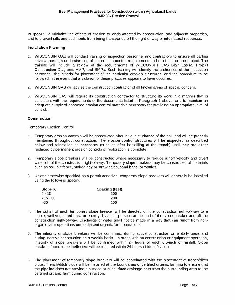
Best Management Practices for Construction within Agricultural Lands
BMP 03 - Erosion Control
BMP 03 - Erosion Control Page 1 of 2
Purpose: To minimize the effects of erosion to lands affected by construction, and adjacent properties, and to prevent silts and sediments from being transported off the right-of-way or into natural resources.
Installation Planning
1. WISCONSIN GAS will conduct training of inspection personnel and contractors to ensure all parties have a thorough understanding of the erosion control requirements to be utilized on the project. The training will include a review of the requirements of WISCONSIN GAS Blair Lateral Project Construction Diagrams AMP, and BMPs. Such training will identify the authorities of the inspection personnel, the criteria for placement of the particular erosion structures, and the procedure to be followed in the event that a violation of these practices appears to have occurred.
2. WISCONSIN GAS will advise the construction contractor of all known areas of special concern.
3. WISCONSIN GAS will require its construction contractor to structure its work in a manner that is consistent with the requirements of the documents listed in Paragraph 1 above, and to maintain an adequate supply of approved erosion control materials necessary for providing an appropriate level of control.
Construction
Temporary Erosion Control
1. Temporary erosion controls will be constructed after initial disturbance of the soil, and will be properly maintained throughout construction. The erosion control structures will be inspected as described below and reinstalled as necessary (such as after backfilling of the trench) until they are either replaced by permanent erosion controls or restoration is complete.
2. Temporary slope breakers will be constructed where necessary to reduce runoff velocity and divert water off of the construction right-of-way. Temporary slope breakers may be constructed of materials such as soil, silt fence, staked hay or straw bales, sand bags, or wattles.
3. Unless otherwise specified as a permit condition, temporary slope breakers will generally be installed using the following spacing:
Slope % Spacing (feet) 5 - 15 300 >15 - 30 200 >30 100
4. The outfall of each temporary slope breaker will be directed off the construction right-of-way to a stable, well-vegetated area or energy-dissipating device at the end of the slope breaker and off the construction right-of-way. Discharge of water shall not be made in a way that can runoff from non-organic farm operations onto adjacent organic farm operations.
5. The integrity of slope breakers will be confirmed, during active construction on a daily basis and during inactive construction on a weekly basis. In areas with no construction or equipment operation, integrity of slope breakers will be confirmed within 24 hours of each 0.5-inch of rainfall. Slope breakers found to be ineffective will be repaired within 24 hours of identification.
6. The placement of temporary slope breakers will be coordinated with the placement of trench/ditch plugs. Trench/ditch plugs will be installed at the boundaries of certified organic farming to ensure that the pipeline does not provide a surface or subsurface drainage path from the surrounding area to the certified organic farm during construction.
BMP 03 - Erosion Control - continued
BMP 03 - Erosion Control Page 2 of 2
7. Slope breakers will be of adequate height and width to contain and divert a significant rain event. Additionally, slope breakers will be constructed with a two to eight percent outslope to a stable area. In the absence of a stable area, appropriate energy-dissipating devices will be used to direct the flow off of the construction right-of-way. The slope breaker will be compacted during its construction to prevent the water from eroding through the berm. The inlet end of the berm will be located to prevent water from traveling around the berm.
8. The outlet of the slope breaker will be stable enough to filter sediment from the water and retain the sediment within the existing vegetation.
Sediment Barriers
1. Sediment barriers will be installed to stop the flow of sediment. They may be constructed of materials such as silt fence, staked hay or straw bales, sand bags, wattles, or equivalent.
2. Temporary sediment barriers will be installed at the base of slopes adjacent to road crossings until disturbed vegetation has been reestablished and at appropriate locations to prevent siltation into water bodies or wetlands crossed by, or near, the construction work area.
3. Temporary sediment barriers will be maintained until permanent revegetation measures are successful or the upland areas adjacent to wetlands, water bodies, or roads are stabilized. Temporary sediment barriers will be removed from an area when that area is successfully restored
Mulch
1. In general, mulch will not be used as an erosion control measure in agricultural lands. In the event mulch is required by WISCONSIN GAS in consultation with the landowner in agricultural lands, the mulch will be applied according to We-Energies Erosion Control Standards and Procedures.
Permanent Erosion Control Devices
1. To prevent subsurface flow of water through the pipe trench, trench breakers will be installed.
2. The following reference table can be used to locate trench breaker spacing on areas with slopes greater than 5%.
Slope (%) Spacing Recommendations (feet) 5 – 15 300 >15 - 30 200 > 30 100
3. When permanent trench breakers are installed in the trench prior to backfilling, they will consist of sandbags, earth-filled sacks or other approved material. Topsoil will not be used for trench breakers. Trench breakers are required to have a minimum bottom width of two sacks wide.
4. Trench breakers will be installed to a minimum elevation of one-foot above the top of the pipe. The top of the trench breaker must be two feet or more below the restored surface on agricultural land.

Best Management Practices for Construction within Agricultural Lands
BMP 04 - Drain Tile
BMP 04 - Drain Tile Page 1 of 2
Purpose: To ensure that any tile line damaged during construction is repaired to a condition that is functionally equivalent to its condition prior to construction and to avoid adverse impacts to planned or proposed drainage systems.
Installation Planning
1. Identify fields containing drain tiles through contact with landowners, the local Land Conservation District, and the USDA-Natural Resources Conservation Service staff. All drain tiles will be photographed and GPS documented pre-construction and post-construction.
2. Flag all identified drain tiles within the right-of-way after clearing and grading, and prior to trenching.
3. WISCONSIN GAS will document proposed drain tile plans that the landowner may plan to install within the three years following construction.
4. WISCONSIN GAS will identify local drain tile installation contractors and consult with the landowner to determine whether the landowner would prefer repair/replacement services (if necessary) be provided by a local contractor.
5. WISCONSIN GAS will document existing moisture content.
Construction
1. The excavated pipeline trench shall provide a minimum of 12 inches clearance, where practicable, between the pipe and the drainage tile.
General Conditions
1. WISCONSIN GAS will use the construction contractor or their sub-contractor to replace, relocate or reconfigure existing tile lines as may be required.
2. WISCONSIN GAS will take the necessary actions to ensure the functioning of the tile lines will be equivalent to its prior condition where tile lines adjacent to the pipeline’s right-of-way are adversely affected by the construction of the pipeline. This may include the relocation, reconfiguration, and replacement of the existing tile lines within the construction corridor. The repaired drain tile will be verified that it was installed correctly and WISCONSIN GAS will make an effort to understand the existing conditions within the limited pipeline ROW.
3. The quality of all clay and concrete drain tile and corrugated polyethylene tubing to be installed shall be appropriate for the work as determined by the AI and/or qualified drain tile repair contractor. Material to be installed will meet American Society of Testing Materials (ASTM) standards.
4. Any drain tile removed from the pipeline trench will not be reused.
5. WISCONSIN GAS will repair or correct tile or drainage problems caused by construction of the pipeline immediately, upon written notice from the landowner to WISCONSIN GAS of such a problem, unless WISCONSIN GAS can demonstrate that the problem identified by the landowner was not caused by actions performed during such construction or restoration. WISCONSIN GAS may arrange a pay settlement to the landowner.
Locating Damaged Drains

BMP 04 - Drain Tile - continued
BMP 04 - Drain Tile Page 2 of 2
1. All drains found during trenching will be flagged.
2. Drains that are located within the right-of-way, but are not located within the trench, will be probed (examined) for damage.
Temporary Repairs
1. All exposed tiles will be capped or screened with window screen or equivalent to protect against soil intrusion when the trench is dug, whether repaired immediately or later.
2. Any flowing tile line will be repaired as soon as practicable with solid tubing, until permanent repairs can be made.
3. Temporary repairs are needed if a flowing drain will be stopped for longer than 24 hours.
Permanent Repairs
1. All permanent tile line damaged within the trench area will be repaired prior to backfilling at the respective location.
2. Where tile lines are severed by construction of the pipeline trench, angle iron, three-sided steel channel iron, I-beams, full round slotted pipe, perforated plastic pipe or half pipe will be used to support the repaired tile line. The support members must extend a minimum of 2-feet into previously undisturbed soil. If the tile repairs involve clay tile, the support member will extend to the first tile joint beyond the minimum 2-foot distance.
3. Each tile drain’s slope (gradient) will be maintained by providing sufficient support to prevent the drain line from sagging. Sandbags, bags of concrete, Sakrete, or equivalent can be used as support under repaired tile lines. The grade of the tile line should remain unchanged.
4. If the tile is clay, ceramic or concrete, any connection with new material must be made with commercially available connectors, or wrapped with plastic or effectively sealed to prevent soil intrusion.
5. To avoid the risk of damaging (crushing) the tile lines with large soil clumps or stones during backfilling loosened native subsoil free of large soil clumps and stones should be placed on top of, and to the sides of, the tile line. Where appropriate native subsoil is not available, imported subsoil free of clumps and stones, or pea gravel, can be used to cushion the tile line.
6. Filter-covered drain tiles will be used where the existing tile line is covered with a filter.

Best Management Practices for Construction within Agricultural Lands BMP 05 - Trench Dewatering
BMP 05 - Trench Dewatering
Page 1 of 2
Purpose: Pump water from an open trench or other excavated area while controlling the rate of discharge to avoid:
• Permanent or temporary erosion and scour;
• Damage to adjacent agricultural land, crops, or pastureland;
• Inundating crops for more than 24 hours, including rainfall;
• Depositing sand, silt, or sediment in or near a wetland or waterbody;
• Depositing gravel in fields, pastures, or watercourses; and
• Damaging cultural resources sites, locations of sensitive plant species and organic farming
operations.
Typically, the trench will need to be dewatered for purposes of, but not limited to, tie-ins, measuring the trench for bends, lowering-in pipe, trench inspection, and back-filling the trench. Water discharge from hydrostatic testing following backfilling shall follow the same protocols described here when applicable.
Installation Planning
1. Water will be discharged in an upland area so any sediment, stones, and silt-laden water will not deposit material in a sensitive area adversely impacting the hydrology or plant communities. The contractor should have sufficient intake or outlet hose (250 - 350 feet) to reach the nearest appropriate upland area.
2. WISCONSIN GAS and their construction contractors will identify during construction activities:
• Low areas along the pipeline route that are likely to collect water during construction, and
• Suitable areas for the discharge of water accumulated within the pipe trench or other
excavated area
• Identify accumulated water that needs to be discharged as construction progresses
3. WISCONSIN GAS will require its construction contractors to obtain:
• WISCONSIN GAS approval of all off-right-of-way and on-right-of-way discharge locations and techniques, and all trench dewatering discharge locations and techniques
• WISCONSIN GAS may obtain voluntary permissions with landowners
4. WISCONSIN GAS will require its construction contractors to structure the work to minimize the accumulation of water within the trench.
5. In the event it is not possible to avoid water-related damages as described above, WISCONSIN GAS will:
• Reasonably compensate the landowner for the damages, and
• Restore the cropland and crops, pastureland, water courses, and any other damaged lands to their pre-construction condition.
Construction
1. All dewatering activities will be conducted in compliance with current drainage laws, local ordinances relating to such activities, WDNR permit conditions, and the provisions of the Clean Water Act.

BMP 05 - Trench Dewatering - continued
BMP 05 - Trench Dewatering
Page 2 of 2
2. Rainwater or groundwater that collects in the trench will be pumped:
• Onto a well-vegetated area that will prevent the water from returning to the right-of-way, or
• Into a filter bag or a settling basin constructed of straw bales when adequate vegetation is
absent or when in the vicinity of a wetland or waterbody.
Additionally, sediment barriers or similar erosion control measures may be used as necessary to divert the flow of pumped water.
3. To minimize the extraction of silt or sediment from the trench the intake will be prevented from touching the bottom or side of the trench. A flotation device or a support will be attached to the intake of the suction line to prevent sucking up soil and other debris from the trench.
4. All structures will be located in a stabilized and vegetated area with a minimum buffer width of 100 feet between it and any adjacent water body or wetland area. Sediment barriers or similar erosion control measure will be installed if an adequate buffer is not available.
5. Preferably, dewatering efforts will not deliver water onto cropland. If it is absolutely necessary to do so, the crops will be inundated (flooded) less than 24 hours.
6. The dewatering activities will not deposit gravel, sediment (mud) or other debris in fields, pastures, or watercourses.
7. Dewatering sites will be selected, and structures and slope breakers will be installed, to ensure that water is not directed into known cultural resources sites or locations of sensitive plant communities.
8. Backfill activities will begin as soon as possible after pipe installation to prevent the trench from refilling with water in high water table conditions. Attempts to dewater as far from the back-filling activity as possible will be made.
9. Dewatering will be monitored and stopped, if necessary, to correct conditions and practices that do not comply with this best management practice.
10. Discharge of water from the trench of non-organic farm operations and hydrostatic testing shall not be made in a way that can runoff onto adjacent organic farm operations.

Best Management Practices for Construction within Agricultural Lands
BMP 06 - Soil Restoration
BMP 06 - Soil Restoration Page 1 of 3
Purpose: To restore the contour and to ensure the quality and agricultural productivity of the soil by:
• Avoiding the mixing of the topsoil with the subsoil, and • Eliminating compaction from the subsoil and topsoil layers, and
• Assuring the rock content of the upper 12-inches of topsoil and subsoil is not increased after
completion of the construction and restoration process.
Installation Planning
1. WISCONSIN GAS will identify, through consultation with the landowner, all rock disposal location(s) on the ROW or adjacent to the ROW. This location can be on the construction right-of-way of the landowner’s property. Written permission from the landowner is required for disposal at another site on the farm.
2. WISCONSIN GAS will consult the landowner about properly disposing of excess excavated material to maintain agricultural productivity.
3. Successful restoration of the soil requires that the proper equipment be used, in the proper sequence, under the correct soil moisture content conditions. Each step in the restoration process is completed before moving to the next step. De-compaction will occur as determined necessary by the Agricultural Inspector (AI) and in consultation with the contractor and landowner.
4. Heavy equipment will not be allowed to cross those agricultural areas that have been de-compacted. In the event any area of previously restored right-of-way that is traversed by equipment for any reason (e.g. to reach a hydrostatic test location) which results in further compaction, the area will be appropriately restored.
Construction:
Backfilling
1. After installation of the pipeline is complete, the trench materials will be backfilled in the order in which they were removed.
Crowning the Trench
1. Crowning the trench area will compensate for ground settling or subsidence. The crown shall be constructed with native topsoil material. Topsoil from adjacent ROW areas will be used (if needed) for crowning to avoid the potential for mixing of subsoil and topsoil in the event settling is overestimated. The AI will determine the height of the crown based on soil type and moisture content. Breaks will be left in the crown to accommodate existing surface drainage systems while the crown settles over the first year post construction.
2. Crowning the trench will be used when necessary and performed per WISCONSIN GAS standards.
3. If in the first growing season post-construction the landowner determines that the crown area may have settled too much or too little and is causing a problem with agricultural activity, WISCONSIN GAS will consult with the landowner to determine what corrective action may be needed to restore the crown area to its pre-construction topography and productivity.
De-compacting the Subsoil
1. Deep subsoil ripping shall be carried out on all traffic and work areas of agricultural right-of-way where full corridor stripping of topsoil occurred. This includes the pipeline workspaces, temporary workspaces, and temporary access roads. It does not include the area over the trench.

BMP 06 - Soil Restoration - continued
BMP 06 - Soil Restoration Page 2 of 3
2. De-compaction of the subsoil will only be done when the subsoil condition is friable/tillable in the top 18-inches of the subsoil profile as determined by the AI. The AI, using their best judgment, may need to allow the de-compaction of the subsoil in areas where soils appear to be either predominantly wet or in low lying areas where water ponding has occurred due to the “trench effect” as a result of topsoil removal. In these cases the AI will consult with, and receive approval from, the landowner or tenant.
3. Ripping equipment to be used will be selected based on successful use on previous pipeline projects such as the v-ripper, chisel plow, paraplow, or an equivalent. WISCONSIN GAS may, at their discretion, choose to compensate the landowner to chisel plow his impacted land(s).
4. The normal depth of tillage is 18-inches. The AI will provide guidance on the appropriate depth of rip in special situations or soil types. For example, a depth of 6 to 8-inches may be appropriate on intensively drained mineral (lacustrine/alluvial) soils. A depth of 22-inches may be appropriate for a deeply and severely compacted area.
5. The optimal spacing of the shanks will depend on the ripping equipment, soil type and moisture content, but will typically be in the range of 8 to 24-inches. Shanks are at their optimum spacing when the implement shatters the soil area between the shanks. Shatter is evidenced by the soil lifting between the shanks as the implement passes. The AI can assist the contractor in selecting the appropriate shank spacing.
6. Subsoil compaction will normally be alleviated with three passes of the de-compaction equipment. Multiple passes refers to the implement passing over the same soil band. That is, three passes of a 10-foot wide implement will treat a 10-foot wide band of soil, not a 30-foot wide band.
7. Passes must be made in multiple directions. This can be achieved in the narrow pipeline right-of-way by weaving the implement back and forth across the area being ripped.
8. If de-compaction was not successful, the de-compaction effort will continue. The contractor is required to make as many passes as necessary to alleviate compaction. If the de-compaction effort is not successful after additional passes, a change in the de-compaction equipment used would be appropriate, and determined with guidance from the AI.
Topsoil Replacement
1. The topsoil will be replaced to its original depth across the spoil storage, trench, work, and traffic areas. The layer of replaced topsoil should be uniform across the right-of-way width, including the crown over the trench.
2. Topsoil should be replaced with small tracked machinery or equivalent light loaded equipment to avoid compaction of the topsoil and subsoil layers. Rubber tired motor graders may be used to spread and level topsoil to address unevenness in the field due to pipeline construction. In areas where minimal tillage, no-till, or level land farming practices are employed, a motor grader will be required to establish final ROW grades.
De-compacting Through the Topsoil
1. De-compaction through the topsoil may be necessary if the subsoil and/or topsoil are compacted during topsoil replacement activities.
Final Rock Removal
1. Replacing the topsoil (or de-compacting through the topsoil) may free some rocks and bring them to the surface.
2. The size, density and distribution of rock remaining on the construction work area should be the same as adjacent areas not disturbed by construction
Final Cleanup

BMP 06 - Soil Restoration - continued
BMP 06 - Soil Restoration Page 3 of 3
1. Any area of previously restored right-of-way should not be traversed by unnecessary equipment traffic. All construction-related debris, including litter generated by the construction crews, will be removed from the landowner’s property and disposed of appropriately.
2. Final clean-up begins immediately after all the other above-mentioned sequence of restoration activities operations are completed, and not before. Final clean-up includes installation of permanent erosion control measures and disposal of construction debris and will be completed within 14 days after backfilling in the area, weather permitting, or as soon as possible thereafter. Final clean-up shall not be delayed until the end of the next seeding season. If final clean-up is not completed within the 14-day time period, temporary erosion controls will be installed.

Best Management Practices for Construction within Agricultural Lands
BMP 07 - Seeding and Seed Bed Preparation
BMP 07 - Seeding and Seed Bed Preparation Page 1 of 2
Purpose:
1. To place the seed into the soil at the correct time and proper depth to promote sufficient seed-soil contact on cropland or pasture requiring seeding.
2. To prepare the soil surface of an exposed area by natural or artificial means, such as tilling and fertilizing.
3. To minimize topsoil erosion on disturbed agricultural areas.
Installation Planning
WISCONSIN GAS will reseed over the entire right-of-way following final clean-up. WISCONSIN GAS will not apply seed to certified organic farms, prior to consulting with the landowner regarding how reseeding will be accomplished.
1. WISCONSIN GAS will attempt to identify properties during the pre-construction phase where cropland seeding procedures or pasture seeding procedures will be used.
2. During recommended seeding periods, seedbed preparation should immediately follow soil restoration as soon as weather conditions and individual right-of-way requirements permit.
3. Seeding will be completed immediately after finishing seedbed preparation, weather permitting. Temporary erosion control measures will be used if this timeframe cannot be met.
4. For seeding outside of the recommended seeding periods, temporary erosion control methods will be used.
5. WISCONSIN GAS will consult with the landowner to determine the seed mix, if appropriate.
Construction
Seed Selection
1. An annual oat, wheat, or similar grain will be used for erosion control on crop land and a special pasture seeding mix will be used for all pastures.
Seedbed Preparation for Conventional, Broadcast and Hydroseeding
1. The ideal condition for conventional seeding is a smooth, firm, clod-free soil for optimum seed placement with drills or cultipacker seeders, if appropriate for that type of seed. The soil should be firm enough at planting for an adult footprint to sink no deeper than 3/8-inch. Avoid overworking the soil because rainfall following seeding may crust the surface, preventing seedling emergence.
2. If the area to be seeded has been recently loosened, and will provide an adequate seedbed, no additional tillage will be required.
3. If the area to be seeded has been compacted or crusted, the top layer of soil will be tilled.
4. Spike–toothed harrows may also be used during seedbed preparation. The spikes of the harrow will dig lightly into the soil to break up soil masses. Harrows may also be used to cover broadcast seed.
5. The seedbed will be scarified to create sites for seed to lodge and germinate where broadcasting the seed or hydroseeding will be used.
Seeding
1. Seeding of permanent cover will be done, whenever possible, during the recommended seeding date ranges for west central Wisconsin.
2. If seeding cannot be accomplished before the recommended October 15 seeding deadline, it will be done in conformity with the Critical Area Planting conservation practice standard of the NRCS, or temporary erosion controls will be implemented and the seeding of permanent cover done at the beginning of the next seeding season.

BMP 07 – Seeding and Seed Bed Preparation – continued
BMP 07 - Seeding and Seed Bed Preparation Page 2 of 2
3. Any soil disturbance occurring outside of the recommended October 15 seeding deadline date, or any bare soil left unstabilized by vegetation, will be treated as a winter construction condition and appropriate erosion controls will be installed to minimize erosion over winter and spring thaw.
4. After seedbed preparation, the seed mixes of all the permanent grasses or legume plantings will be applied at the rate determined from the , Agricultural Inspector, landowner or recommended by the USDA-Natural Resources Conservation Service (NRCS).
5. In areas where a different seed mix is proposed, seeding will conform to the Critical Area Planting conservation practice standard of the NRCS, Conservation Reserve Program or any other similar federal program.
6. Grass waterways and terraces will be seeded to reestablish grass cover similar to preconstruction conditions. Erosion control measures, such as mulch or erosion control fabric, will be used in conjunction with seeding.
7. If a Certified Organic Farm will be impacted by construction, WISCONSIN GAS will coordinate with the affected landowner to ensure that an appropriate seed mix and planting methods are used as required by the farm’s Certification Plan.

Best Management Practices for Construction within Agricultural Lands
BMP 08 - Crop Compensation
BMP 08 - Crop Compensation Page 1 of 1
Purpose: To ensure that agricultural landowners are fairly compensated for loss of crop production due to the pipeline project.
Planning:
1. WISCONSIN GAS will compensate the landowner for crop loss once at the beginning or the end of the project. If the landowner rents or leases out the land to a renter, then the renter may be compensated in lieu of the landowner. There will be an attempt to communicate the agreement of compensation to both the renter as well as the landowner.
2. The value of the crop will be determined by the Payment Worksheet in the Easement Agreement Package. Crop compensation will be based on September/October 2016 futures and will be adjusted upward in year of construction if crop prices increase, but will not change if crop prices decline.
3. The landowner/renter will be compensated a total of 200% of the value of the crop based on the calculation in Item 2 above. 100% of the value of the crop during the year of construction, 60% the first year after construction, and 40% the second year after construction.
4. The landowner/renter would signify agreement by signing a damage release form.

Best Management Practices for Construction within Agricultural Lands BMP 09 - Three-Lift Soil Handling
BMP 09 - Three-Lift Soil Handling 1 of 1
Purpose: To maintain the root zone over the trench area to the extent practicable through management of the topsoil, and subsoil layers in areas where the subsoil qualifies for this three-lift protocol.
Organization: The contractor will be responsible for implementing the three-lift soil-handling method. The Agricultural Inspectors (AI) will be available to assist in making “field calls” such as identifying boundaries between soil layers and to monitor compliance with this BMP.
Installation Planning:
1. In areas where the AI determines the need to apply the triple-lift soil handling practice during trenching operations, an attempt will be made in preconstruction planning to ensure that adequate construction right-of-way space is made available. WISCONSIN GAS will compile a list of potentially affected farmland owners whose land is eligible for triple lift soil handling during excavation of the trench. This will be obtained from NRSC Soil Maps and/or original soil maps for each county. This list of qualifying "candidate" soils and parcels will be provided to the Wisconsin Department of Agriculture, Trade, & Consumer Protection (WDATCP) and to the Agricultural Inspectors (AIs).
2. The criteria for soils qualifying as "candidates" for the three-lift soil handling procedure are determined by WDATCP on lands that involve cultivated croplands, rotated pastureland, or government set-aside program land. Locations of tree-lift soil handling will be confirmed by the AI.
3. Where applicable, WISCONSIN GAS will inform landowners possessing lands containing soils within the construction right-of-way (ROW) that meet the three-lift soil handling criteria and offer landowners the option of implementing the three-lift soil trenching procedure on their property during construction.
4. WISCONSIN GAS will include in the construction bid documents explanation of the three-lift soil handling procedure along with the potential locations. WISCONSIN GAS will also review the process and the potential locations with the bidders during the pre-bid job showing to ensure the potential contractor is well acquainted with the expectations. WISCONSIN GAS will also review this process and the potential locations with the selected construction contractor during the construction “kick-off” meeting. The three-lift soil handling process will also be included in WISCONSIN GAS’s environmental training sessions required for all field personnel prior to working on the construction right-of-way.
Construction:
1. WISCONSIN GAS may perform additional soil sampling to confirm the depth and extent of soil layers.
2. All topsoil up to a depth of at least 12 inches of will be stripped and stockpiled along the edge of the working side of the construction ROW.
\
3. After topsoil has been removed (first lift) and trenching begins, a backhoe will remove the upper portion of the subsoil (second lift) and place this layer as far from the trench as the reach of the equipment permits on side of the construction ROW.
4. Where the subsoil material changes the backhoe operator will place this underlying material (third lift) between the trench and the second-lift pile on the side of the right-of-way. Since the depth at which the underlying material is encountered will vary from location to location, the boundary between the upper subsoil and the underlying material will be determined visually by the construction and inspection team, with the advice of the AI when necessary.
5. WISCONSIN GAS will attempt to maintain separation between the two piles. Depending on the available workspace and the volume of soil involved, maintaining complete separation between these two piles may not be possible.
6. During backfilling, the operator will make every effort to place the lower subsoil pile material (third layer) of the spoil material in the trench first, and will only then replace the upper subsoil layer (second layer) of the spoil material in the trench.
7. WISCONSIN GAS will perform field adjustments as necessary in conjunction with the contractor and AI to ensure lower subsoil or parent material does not become mixed with the upper subsoil by the proper placement of the spoil piles to the extent practicable.


WISCONSIN DEPARTMENT OF AGRICULTURE, TRADE AND CONSUMER PROTECTION
DIVISION OF
AGRICULTURAL RESOURCE MANAGEMENT
Agricultural Impact Program
P.O. Box 8911
Madison, WI 53708-8911
608-224-4650
https://datcp.wi.gov/Pages/Programs_Services/AgriculturalImpactStatements.aspx