Aggregate Resources Master Plan for the United Counties of ...
79
1 Aggregate Resources Master Plan for the United Counties of Leeds and Grenville Draft v1 October 4, 2021
Transcript of Aggregate Resources Master Plan for the United Counties of ...

1
Aggregate Resources Master Plan
for the
United Counties of Leeds and Grenville
Draft v1
October 4, 2021

2
1. Introduction ................................................................................................................... 4
2. Legislative and Policy Context ......................................................................................... 7
2.1 Planning Act ............................................................................................................. 7
2.2 Provincial Policy Statement ....................................................................................... 8
3. Overview of ARIP 183 ................................................................................................... 13
3.1 Selected Sand and Gravel Resource Areas ............................................................... 15
3.2 Selected Bedrock Resource Areas ............................................................................ 16
4. Overview of the Counties Official Plan .......................................................................... 20
5. Review of Lower-Tier Official Plans ............................................................................... 32
5.1 Township of Athens ................................................................................................ 33
5.2 Township of Augusta .............................................................................................. 38
5.3 Township of Edwardsburgh Cardinal ....................................................................... 41
5.4 Township of Elizabethtown-Kitley ........................................................................... 45
5.5 Township of Front of Yonge .................................................................................... 46
5.6 Township of Leeds and the Thousand Islands .......................................................... 48
5.7 Village of Merrickville-Wolford ............................................................................... 51
5.8 Municipality of North Grenville ............................................................................... 54
5.9 Township of Rideau Lakes ....................................................................................... 55
5.10 Village of Westport ................................................................................................. 57
5.11 Summary of Mapping in the Lower-Tier Official Plans .............................................. 57
6. What We’ve Heard ....................................................................................................... 59
6.1 Technical Steering Committee Meeting ................................................................... 59
6.2 Industry Stakeholder Meeting ................................................................................. 59
6.3 Open House Meeting .............................................................................................. 60
6.4 Summary of Other Comments ................................................................................. 61
7. Proposed Mapping ....................................................................................................... 66
7.1 Proposed Bedrock Mapping .................................................................................... 67
7.2 Proposed Sand and Gravel Mapping ........................................................................ 68
8. Official Plan Recommendations .................................................................................... 69
8.1 Assessment Requirements ...................................................................................... 71
8.2 Assessment Exemptions .......................................................................................... 75
8.3 Mineral Aggregate Operations ................................................................................ 76

3
8.4 Application Requirements ....................................................................................... 78
8.5 Mapping ................................................................................................................. 79
4
1. INTRODUCTION Aggregates are required for virtually all types
of construction and infrastructure and
according to the Ontario Aggregate
Resources Corporation in 2020, "the
economic activity generated by the industry
begins with the aggregate production itself
but also feeds industries which receive and
use the raw materials: including cement and
concrete products, other aggregate-based
products (asphalt, chemical, clay, glass, etc.)
and construction." In 2020, there were 3,601
licenses for pits and quarries on private lands
in southern and central Ontario and 167
million tonnes of aggregate was extracted,
which equates to about 14 tonnes per
person in Ontario.
The establishment of new pits and quarries
has long been a polarizing process in Ontario.
While extraction is intended to be an interim
use and aggregates are required for virtually
all types of construction and infrastructure,
opposition to almost every new pit or quarry
is commonplace, even though there is a
need for aggregates. In recognition of this
need, Provincial land use policies are very
supportive of aggregate extraction.
However, the current application process for
new or expanding resource uses in Ontario
requires an investment of several years and
significant resources for detailed technical
studies, with most applications ending up at
the Ontario Municipal Board (now the
Ontario Land Tribunal (‘OLT’)).
The Planning Act identifies mineral
aggregate resources as a matter of Provincial
interest and requires that the Province and
municipalities integrate consideration for
such resources in land use planning
decisions. The Provincial Policy Statement
(‘PPS’) requires municipalities to identify and
protect mineral aggregate resources in their
respective Official Plans for long-term use.
The PPS defines deposits of mineral
aggregate resources as follows:
Deposits of mineral aggregate resources:
means an area of identified mineral
resources, as delineated in Aggregate
Resource Inventory Papers or comprehensive
studies prepared using evaluation
procedures established by the Province for
surficial and bedrock resources, as amended
from time to time, that has a sufficient
quantity and quality to warrant present or
future extraction.
The above means that municipalities are
required to identify mineral aggregate
resources on a map and include a policy
framework that establishes what can
happen on lands that contain mineral
aggregate resources as well as on adjacent
lands.
5
On July 23, 2015, the United Counties of
Leeds and Grenville (‘UCLG’) adopted its first
Official Plan. The Ministry of Municipal
Affairs and Housing (‘MMAH’) approved the
Official Plan (‘Counties OP’), with
modifications, on February 19, 2016.
As part of the Official Plan review process a
Background Report containing policy options,
dated August 2014, was prepared. This
Background Report included a Draft
Schedule B1 – Mineral Aggregate Resource
Areas, Constraints Areas and Waste Disposal
Sites (‘Draft Bedrock Schedule’). This Draft
Bedrock Schedule included the locations of
primary, secondary and tertiary sand and
gravel resource areas as well as bedrock
resource areas, among other layers. It is
noted that at the time the Ministry of
Natural Resources and Forestry (‘MNRF’)
(now referred to as the Ministry of Northern
Development, Mines, Natural Resources and
Forestry (‘MNDMNRF’)) required that
primary, secondary and tertiary sand and
gravel resources be identified, given that
there are only a small number of primary and
secondary sand and gravel resource areas
within the UCLG.
On the Draft Bedrock Schedule described
above, bedrock resource areas were
identified on approximately two thirds of the
UCLG and it was the thinking at the time that
this information was to be portrayed as an
overlay in the Counties OP and not a land use
designation. A number of concerns were
raised during the Counties OP Review
process about the extent of bedrock
resources in the UCLG and concerns over
minimizing the impacts of new or expanding
mineral aggregate operations. In addition to
this, the UCLG was faced with a compressed
timeline to complete the Counties OP
Review that did not allow for a
comprehensive exercise to refine the
delineation of bedrock resource areas. As a
result, bedrock resource areas did not end
up being identified on any schedule in the
adopted Counties OP.
On the basis of the above, the Counties OP
was modified through the approval process
to indicate that the UCLG must complete an
Aggregate Resources Master Plan (‘ARMP’)
to address specific aggregate and bedrock
issues within three years of the approval of
the Counties OP. In this regard, an Official
Plan Amendment is required to implement
the ARMP once complete.
The development of an ARMP provides the
UCLG with an opportunity to protect mineral
aggregates for long-term use while being
proactive on what the UCLG's expectations
are in terms of where extraction is
potentially anticipated to occur in the future
and under what conditions. In addition, an
opportunity exists for the UCLG to take the
lead on policy approaches to minimize social,
economic and environmental impacts that

6
reflect UCLG objectives. In this regard, the
Counties established a number of objectives
for the ARMP and these include:
• Use existing data and mapping to review
mineral aggregate resources, including
bedrock resources, in the UCLG;
• Examine and identify viable mineral
aggregate resource deposits for
protection and extraction examining
environmental, social and economic
factors;
• Identify and discuss potential
constraints to extraction of mineral
aggregate resources;
• Refine the identified mapping of mineral
aggregate resources in areas of
potential conflict and potential non-
viable deposits, if needed; and,
• Review and update existing Counties OP
policies for mineral aggregate resources,
including bedrock resources, using
current best practices. This review may
also result in criteria that should be
considered when an application is
submitted.
The intent of the ARMP is to provide more
certainty for the industry and the public
when making property investment
decisions, reduce conflict and the time and
resources required to process individual
applications.
There is also an opportunity to re-enforce a
number of key policies in the Counties OP
that have worked well for managing
resource extraction. In addition to this is the
opportunity to incorporate new policies that
strike a balance between competing
environmental, social and economic
interests in order to ensure a high quality of
life for current and future generations.
On the basis of the above, the purpose of this
Aggregate Resources Master Plan is to
provide:
• An overview of the applicable policies in
the Planning Act, PPS and the current
Counties OP framework;
• An overview of the Provincial Aggregate
Resource Inventory Paper 183 that
establishes the extent of sand and
gravel and bedrock resources within the
UCLG;
• An overview of the policy framework in
the lower-tier Official Plans as it relates
to mineral aggregate designation(s) and
select relevant policies;
• A description of the proposed sand and
gravel and bedrock mapping; and,
• A number of policy recommendations
for the Counties OP that apply to sand
and gravel and bedrock resource areas.

7
2. LEGISLATIVE AND
POLICY CONTEXT
2.1 Planning Act
The Planning Act establishes the basic
framework for making land use planning
decisions in Ontario. Section 1.1 of the
Planning Act states that the purposes of the
Act are:
a) To promote sustainable economic
development in a healthy natural
environment within the policy and by the
means provided under this Act
b) To provide for a land use planning
system led by provincial policy
c) To integrate matters of provincial
interest in provincial municipal planning
decisions
d) To provide for planning processes that
are fair by making them open, accessible,
timely and efficient
e) To encourage co-operation and co-
ordination among various interests
f) To recognize the decision-making
authority and accountability of
municipal councils in planning.
Sub-section (a) above is intended to support
sustainable economic development while
providing for a healthy natural environment.
Sub-section (b) above clearly articulates the
Provincial requirement that the ‘land use
planning system’ in Ontario be ‘led by
Provincial policy’.
Subsection (c) builds upon sub-section (b) by
indicating that matters of Provincial interest
should be integrated into Provincial and
municipal planning decisions.
Sub-section (d) provides for an open
planning process while sub-section (e)
encourages co-operation among various
interests. This includes the Province, the
UCLG, the lower-tier municipalities,
landowners, industry and the broader public.
Lastly, sub-section (f) recognizes the
decision-making authority and
accountability of municipal councils in
making planning decisions.
Section 2 of the Planning Act sets out the
responsibilities of the Council of a
municipality and the OLT. Sub-section (c)
identifies mineral aggregates as a matter of
Provincial interest, as follows:
The Minister, the council of a municipality, a
local board, a planning board and the
Tribunal, in carrying out their responsibilities
under this Act, shall have regard to, among
other matters, matters of provincial interest
such as:
8
(c) The conservation and management of
natural resources and the mineral resource
base;
Section 3(5)(a) of the Planning Act states the
following:
A decision of the council of a municipality, a
local board, a planning board, a minister of
the Crown and a ministry, board, commission
or agency of the government, including the
Tribunal, in respect of the exercise of any
authority that affects a planning matter,
shall be consistent with the policy
statements issued under subsection (1) that
are in effect on the date of the decision.
On the basis of the above, land use planning
decisions are required to be consistent with
the PPS.
2.2 Provincial Policy Statement
The current PPS came into effect on May 1,
2020. The PPS provides policy direction to
municipalities on matters of Provincial
interest related to land use planning and
development. Part IV of the PPS establishes
the vision for Ontario’s land use planning
system and it clearly indicates that one of
the keys to the long-term prosperity and
social well-being of Ontario is a strong
economy. Of particular relevance to the
ARMP is the following section:
The Province’s natural heritage resources,
water resources, including the Great Lakes,
agricultural resources, mineral resources,
and cultural heritage and archaeological
resources provide important environmental,
economic and social benefits. The wise use
and management of these resources over the
long term is a key provincial interest. The
Province must ensure that its resources are
managed in a sustainable way to conserve
biodiversity, protect essential ecological
processes and public health and safety,
provide for the production of food and fibre,
minimize environmental and social impacts,
provide for recreational opportunities and
meet its long-term needs.
In this regard, there is an overall public
interest in ensuring that sources of
aggregate such as sand and gravel and
bedrock are as close to market as possible to
ensure costs are low and that there is
competition in the marketplace. Given that it
is the public that generally pays for
infrastructure through taxation from one
level of government or another, there is a
clear public interest in ensuring that the cost
to the general public of infrastructure is kept
low when feasible and practical.
Section 2.5 of the PPS includes policies that
address mineral aggregate and petroleum
resources. Section 2.5.1 requires the long-
term protection of mineral aggregate
resources and it reads as follows:
9
2.5.1 Mineral aggregate resources shall be
protected for long-term use and, where
provincial information is available deposits
of mineral aggregate resources shall be
identified.
As noted previously, the PPS defines
deposits of mineral aggregate resources as
follows:
Deposits of mineral aggregate resources:
means an area of identified mineral
resources, as delineated in Aggregate
Resource Inventory Papers or comprehensive
studies prepared using evaluation
procedures established by the Province for
surficial and bedrock resources, as amended
from time to time, that has a sufficient
quantity and quality to warrant present or
future extraction.
On the basis of the above, the mapping
contained within Aggregate Resource
Inventory Paper 183 (‘ARIP 183’) identifies a
number of Selected Bedrock Resource Areas
and Select Sand and Gravel Resource Areas
within the UCLG. In this regard, the above
means that following the completion of the
ARMP, the Counties OP will need to be
amended to include a map of resources as
shown in the ARIP 183.
There are two PPS policies in particular that
have a significant impact on aggregate policy
development and the review of applications
since they require decision makers to
consider how the Provincial interest in the
"conservation and management of natural
resources and the mineral resource base (Sec.
2 of the Planning Act)" will be balanced
against other matters of Provincial interest
that relate to the protection of ecological
systems, the orderly development of safe
and healthy communities and the
appropriate location of growth and
development, among others. These two
policies are Sections 2.5.2.1 and 2.5.2.2,
both of which are reproduced below:
Section 2.5.2.1 - As much of the mineral
aggregate resources as is realistically
possible shall be made available as close to
markets as possible.
Demonstration of need for mineral
aggregate resources, including any type of
supply/demand analysis, shall not be
required, notwithstanding the availability,
designation or licensing for extraction of
mineral aggregate resources locally or
elsewhere.
Section 2.5.2.2 - Extraction shall be
undertaken in a manner which minimizes
social, economic and environmental impacts.
Section 2.5.2.1 recognizes that mineral
aggregate resources are an integral
component of the economy and that the
transportation of this resource to market is

10
cost sensitive. There is no definition of
“realistically possible” in the PPS.
The use of word 'shall' in the context of this
policy makes it clear that planning
authorities must take this direction into
account when making planning decisions.
The second component of the policy makes
it clear that the demonstration of need for
mineral aggregate resources is not a factor in
the development of resource strategies or in
the consideration of individual applications,
regardless of the municipality or location.
Section 2.5.2.2 of the PPS then acts as the
'control' over where new resource uses are
to be located and is intended to ensure that
the policy in Section 2.5.2.1 is balanced
against the expressed desire to minimize
impacts. In this regard, Section 2.5.2.2
provides the basis for the establishment of
criteria to identify potential resource areas
and to assess applications to establish
resource uses. It is noted that the word
'shall' is also used in this section. This section
also uses the word “minimize” with no
definition of “minimize” provided in the PPS.
As a result, the determination of whether
extraction minimizes social, economic and
environmental impacts is the most
important consideration in making a
decision on an application to establish a new
resource use. It is also noted that the use of
the word ‘minimize’ assumes and recognizes
that some impacts will occur.
There are a number of other policies in the
PPS that are directly or indirectly supportive
of the mineral aggregate industry and the
extraction of mineral aggregate resources,
recognizing the important role that it plays in
our economy and in the availability and
efficient delivery of needed services and
infrastructure. However, there are other
policies that indicate that development and
land use patterns which may cause
environmental or public health and safety
concerns should be avoided and that uses
such as resource extraction activities and
sensitive land uses are appropriately
designed, buffered and/or separated from
each other to prevent adverse effects.
The challenge in developing a policy
framework relating to aggregates is
determining how to apply the many polices
in the PPS that potentially apply. For
example, Section 2.1.4 indicates that
development and site alteration shall not be
permitted in certain natural heritage
features. Section 2.2.2 indicates that
development and site alteration shall be
restricted in or near sensitive surface water
features and sensitive ground water features
such that these features and their related
hydrologic functions "will be protected,
improved or restored." Section 2.5.2.1 of the
PPS then indicates that, as much of the
mineral aggregate resources as is realistically
possible shall be made available as close to
markets as possible. It is then noted in Part

11
III of the PPS indicates that the PPS shall be
read in its entirety and all relevant polices
are to be applied to each situation. The use
of the word 'shall' in each of these policies
indicates that the policy is 'mandatory'.
All of the ‘shalls’ mentioned above will need
to be balanced in developing an updated
policy framework.
As noted earlier, one of the main purposes of
the ARMP is to identify Selected Bedrock
Resources on a map. During the preparation
of the current Counties OP, there had been a
number of concerns raised about the extent
of land in this category and its impact on
potential future development. This is
because once the Selected Bedrock
Resource Areas are identified in an Official
Plan, Section 2.5.2.5 of the PPS is triggered.
Section 2.5.2.5 of the PPS reads as follows:
In known deposits of mineral aggregate
resources and on adjacent lands,
development and activities which would
preclude or hinder the establishment of new
operations or access to the resources shall
only be permitted if: a) resource use would
not be feasible; or b) the proposed land use
or development serves a greater long-term
public interest; and c) issues of public health,
public safety and environmental impact are
addressed.
As set out in Section 2.5.2.5 of the PPS, an
assessment of the impacts of proposed
development on the feasibility of resource
extraction is required to be carried out
whenever development is proposed with
development being defined as development
requiring a Planning Act approval. It is noted
that items a) and b) in Section 2.5.2.5 are
separated by the word “or”.
This means that it could be considered that a
proposed land use or development serves a
greater long-term public interest than a
proposed resource use even if it is
determined that resource use would be
feasible. This means that the potential exists
as part of the review of any planning
application to make a determination on
what use is in the greater long-term public
interest. In addition to the above, it is noted
that one of the tests is: “The resource use
would not be feasible”. In this regard, the
presence of a resource is not in of itself a
determinant of whether it is feasible to
extract. There are a number of factors that
need to be considered to determine
feasibility and these will need to be
considered in the policy framework of the
future Counties OP Amendment.
The Province has not provided municipalities
with a formal Terms of Reference for
preparing the required assessment by
Section 2.5.2.5 of the PPS. However, the
Province has prepared a draft terms of
12
reference for an aggregate study with the
focus being on severances. This draft
document is a locally developed
consolidation of direction that draws upon
the Ministry of Natural Resources Non-
Renewable Training Manual (1997) and
aggregate study components that have been
used in the past.
The draft document clarifies when a
development application triggers the
completion of a study or studies and sets out
the information required to assess the
impact of a proposed development
application. In this regard, the following
types of information could be requested to
assist a planning authority in determining
the impact of a development application:
• Introduction (includes policy rationale,
scope of work, site description, existing
aggregate use analysis);
• Topography and drainage;
• Geological setting;
• Aggregate resource mapping;
• Site inspection results;
• MOE well record data review;
• Compatibility analysis;
• Constraint assessment;
• Mitigation studies; and,
• A number of figures such as general
location plan, topography and drainage
plan, aerial photography plan,
physiography map, surficial geology
map, aggregate resource area, site
photographs, map of MOE well
locations.
The above information is intended to
provide the planning authority with the
necessary information to make one of the
following four decisions:
1. Determine that the development will
not have any negative impact on the
aggregate resource;
2. Determine that the development will
have negative impact on the aggregate
resource that can be overcome by
appropriate modifications to the design
or construction phases and/or the
adoption of appropriate mitigation
techniques;
3. Determine that the development will
result in negative impacts to extraction
that cannot be overcome by planning,
design or construction changes; or
4. Determine there is still insufficient
information to determine negative
impacts.
While the provision of an official Terms of
Reference by the Province would be helpful,
it could only be construed as being generic at
best since the nature of each development
proposal in relation to the nature of the
resource is potentially unique each time.
This is because in addition to the nature of
the development proposal, the arrangement,

13
location and nature of other land uses in the
area are all site-specific considerations. With
respect to the bedrock resource itself, the
nature of the resource is also potentially
different each time with factors such as the
quality of the resource, the type of the
resource, limitations on the extraction of the
resource for environmental or access
reasons all being conceivably different each
time as well.
As noted above, Section 2.5.2.5 of the PPS is
triggered when 'development' as defined by
the PPS and 'activities' (which is not defined)
are proposed. Given that 'development'
means a change in land use requiring a
Planning Act approval, this section is
triggered by an application to amend the
Official Plan or zoning by-law, and by an
application for Plan of
Subdivision/Condominium, consent or
minor variance. It is not triggered when the
only approval required is for a building
permit pursuant to the Ontario Building
Code to build a new home on a vacant lot.
On the basis of the above, applications to
construct a dwelling or any other use on any
property that is zoned to permit the use
would not trigger Section 2.5.2.5 of the PPS
since a Planning Act approval is not required.
In addition, any application for development
as per the Planning Act within the boundary
of a settlement area would not trigger the
application of Section 2.5.2.5 of the PPS.
Given the above, the future Official Plan
Amendment should include policies that aim
to minimize the impact of Section 2.5.2.5 on
future Planning Act approvals in the
Agricultural Area and Rural Lands
designations. Consideration should also be
given to the types of development that
should be exempt from completing an
assessment as required by Section 2.5.2.5 of
the PPS.
3. OVERVIEW OF ARIP
183 The purpose of this section of the ARMP is to
review the nature and location of mineral
aggregates in the UCLG. It is noted that this
section discusses information that is sourced
primarily by the Ontario Geological Survey
(‘OGS’) of the MNDMNRF.
The OGS is responsible for the Aggregate
Resources Inventory Program (‘ARIP’), the
purpose of which is to provide the basic
geological information required to include
potential mineral aggregate resource areas
in land-use planning strategies and decision-
making processes. According to the
MNDMNRF website, the OGS has existed for
over 125 years.
In 2009, the OGS released ARIP 183 that
includes an inventory and evaluation of sand
and gravel and bedrock resources in the
UCLG. It is noted in the ARIP 183 that overall

14
production had remained close to 2 million
tonnes per year between 1996 and 2005.
According to The Ontario Aggregate
Resources Corporation (TOARC), the 2020
Production Statistics Report indicates that
production rates in the UCLG have been
around 2 million tonnes per year between
2010 and 2020. Below is a summary table of
aggregate production in the UCLG between
2010 and 2020.
Year Tonnage (million tonnes)
2010 2.6
2011 2.0
2012 2.2
2013 1.9
2014 2.2
2015 1.9
2016 2.0
2017 2.2
2018 2.1
2019 2.1
2020 2.0
The ARIP 183 also indicates that population
and aggregate production trends over the
last decade have been relatively stable and
that this suggests that similar production
rates may be expected for the foreseeable
future. This suggestion from the ARIP 183
appears to be correct based on the
production rates published in the TOARC
production statistic reports.
With respect to the quantity of aggregate
within the UCLG, ARIP 183 also noted that:
Reserves of sand and gravel are in very short
supply within the county and it will be
necessary to use crushed bedrock to meet
the demand for most aggregate products.
With respect to the location of mineral
aggregate deposits, the ARIP 183 indicates
the following:
Although mineral aggregate deposits are
plentiful in Ontario, they are fixed-location,
non-renewable resources that can be
exploited only in those areas where they
occur. Mineral aggregates are characterized
by their high bulk and low unit value so that
the economic value of a deposit is a function
of its proximity to a market area as well as its
quality and size. The potential for extractive
development is usually greatest in areas
where land use competition is extreme. For
these reasons the availability of adequate
resources for future development is now
being threatened in many areas, especially
urban areas where demand is the greatest.
The ARIP 183 then indicates that:
The report is a technical background
document based for the most part on
geological information and interpretation. It
has been designed as a component of the

15
total planning process and should be used in
conjunction with other planning
considerations, to ensure the best use of an
area’s resources.
The ARIP 183 identifies selected resource
areas in the UCLG that represent areas in
which a major resource is known to exist.
Below is an overview of the Selected Sand
and Gravel Resource Areas and the Selected
Bedrock Resource Areas as detailed in the
ARIP 183.
3.1 Selected Sand and Gravel
Resource Areas
At the time that the ARIP 183 was prepared,
there were 83 licensed sand and gravel pits
operating in the UCLG. According to the
MNDMNRF Pits and Quarries Online
database (ontario.ca/page/find-pits-and-
quarries), there are currently 74 pits in
operation that comprise a licensed area of
1,629.21 hectares.
In the UCLG, the ARIP 183 identifies eight
Selected Sand and Gravel Resource Areas at
the primary significance level, which occupy
a total area of 799 hectares. The ARIP 183
indicates that once licensed resources are
removed and cultural, environmental and
other land use constraints are considered,
there are an estimated 707 hectares that
remain for possible resource extraction. The
ARIP 183 indicates that this land area is
estimated to include approximately 106.3
million tonnes of sand and gravel. The ARIP
183 does not indicate the area of land that is
included as secondary and tertiary resource
areas.
As discussed further in Section 7.1 of this
ARMP, the proposed sand and gravel
resource mapping is based on the mapping
included in the ARIP 183 as well as additional
land area that has been identified as
resource area from annual updates that
have been completed by the MNDMNRF.
The proposed sand and gravel mapping
includes area calculations based on data
from the MNDMNRF. In this regard, there is
1,266 hectares of primary sand and gravel
resource, 1,664 hectares of secondary sand
and gravel resource and 48, 497 hectares of
tertiary and gravel resource. It is noted that
these area calculations do not take into
account the pre-emptive constraints as
discussed in Section 7.1 of this ARMP.
Map 1 in the ARIP 183 provides an inventory
and evaluation of Selected Sand and Gravel
Resource Areas in the UCLG. The ARIP 183
indicates the following with respect to this
map:
Each area of primary significance is coloured
red on Map 1 and identified by a deposit
number that corresponds to numbers in
Table 3. … Selected Sand and Gravel
Resource Areas of primary significance are
not permanent, single land units. They

16
represent areas in which a major resource is
known to exist and may be reserved wholly
or partially for extractive development
and/or resource protection. In many of the
recently approved municipal Official Plans,
all or portions of resources of primary
significance, and in some cases resources of
secondary significance, are identified and
protected.
Deposits of secondary significance are
coloured orange on Map 1. Such deposits are
believed to contain significant amounts of
sand and gravel. Although deposits of
secondary significance are not considered to
be the “best” resources in the report area,
they may contain large quantities of sand
and gravel and should be considered as part
of the overall aggregate supply of the area.
Deposits of tertiary significance are coloured
yellow on Map 1. They are not considered to
be important resource areas because of their
low available resources or because of
possible difficulties in extraction. Such areas
may be useful for local needs or extraction
under a wayside permit, but are unlikely to
support large-scale development.
Map 1: Sand and Gravel Resources for the
United Counties of Leeds-Grenville, as
shown in the ARIP 183, is included at the end
of this section of the ARMP.
3.2 Selected Bedrock Resource
Areas
At the time that the ARIP 183 was prepared,
there were 37 licensed quarries that
comprise an area of 1,390 hectares.
According to the MNDMNRF Pits and
Quarries Online database
(ontario.ca/page/find-pits-and-quarries),
there are currently 28 aggregate quarries in
operation that comprise a licensed area of
917.81 hectares.
It was further noted in the ARIP 183 that the
majority of the quarries were producing
bedrock-derived crushed stone for use in the
road building and construction industries.
The Selected Bedrock Resource Areas
identified in the ARIP 183 are those that are
covered by less than 8 metres of overburden,
which is a depth that is generally assumed to
be the maximum amount of overburden that
can be removed while still producing viable
product. These areas occupy a possible
resource area of 179,156 hectares in the
UCLG and have a possible aggregate
resource of 71,188 million tonnes.
As discussed further in Section 7.1 of this
ARMP, the proposed bedrock resource
mapping is based on the mapping included in
the ARIP 183 as well as additional land area
that has been identified as resource area
from annual updates that have been
completed by the MNDMNRF. In this regard,
17
the proposed bedrock mapping includes
area calculations based on data from the
MNDMNRF and there is approximately
176,103 hectares of bedrock resource area
within the UCLG. It is noted that this area
calculation does not take into account the
pre-emptive constraints as discussed in
Section 7.1 of this ARMP.
The ARIP 183 identifies 7 Selected Bedrock
Resources Areas and these areas are
restricted to a single level of significance
(unlike the Selected Sand and Gravel
Resources). The ARIP 183 provides the
following reasoning for this difference as
follows:
First, the quality and quantity variations
within a specific geological formation are
gradual. Second, the areal extent of a given
quarry operation is much smaller than that
of a sand and gravel pit producing an
equivalent tonnage of material, and third
since crushed bedrock has a higher unit value
than sand and gravel, longer haul distances
can be considered.
The ARIP 183 states the following with
respect to the type of geology that exists
within the UCLG:
The study area is underlain by Precambrian
rocks, the Cambro–Ordovician Potsdam
Group, and the Ordovician March, Oxford
and Gull River formations. The central and
eastern portion of the study area is part of
the Ottawa–St. Lawrence Lowlands, a large
basin lying between the Canadian Shield to
the north and west and the Adirondack
Mountains to the south. The western
boundary of this basin is the Frontenac Axis,
which trends southeast through the
Thousand Islands area and underlies the
western part of the county. The eastern
extent of the basin is at the Beauharnois
Anticline near the junction of the Ottawa and
St. Lawrence rivers.
Map 2 in the ARIP 183 identifies Bedrock
Resource Areas and it shows the distribution
of bedrock formations and thicknesses of
overlying unconsolidated sediments. The
ARIP 183 indicates the following with respect
to this map:
The darkest shade of blue indicates where
bedrock crops out or is within 1 m of ground
surface. These areas constitute potential
resource areas because of their easy access.
The medium shade of blue indicates areas
where drift cover is up to 8 m thick.
Quarrying is possible in this depth of
overburden and these zones also represent
potential resource areas. The lightest shade
of blue indicates bedrock areas overlain by 8
to 15 m of overburden.
Map 2: Bedrock Resources for the United
Counties of Leeds-Grenville, from the ARIP

18
183, is included at the end of this section of
the ARMP.
In addition to the above, the ARIP 183
further notes that:
Selected Bedrock Resource Areas shown on
Map 2 are not permanent, single land use
units. They represent areas in which a major
bedrock resource is known to exist and may
be reserved wholly or partially for extractive
development and/or protection, within an
Official Plan.

19

20
4. OVERVIEW OF THE
COUNTIES OFFICIAL
PLAN The UCLG Official Plan (‘Counties OP’)
provides policy direction on matters of
County-wide significance, such as mineral
aggregate resources, and it is intended to
provide policy direction to the 10 lower-tier
municipalities that comprise the UCLG. The
purpose of this section of the ARMP is to
identify and discuss the Counties OP policies
that currently apply to mineral aggregate
resources.
The Counties OP includes a number of
strategic directions to guide planning within
the UCLG. With respect to mineral
aggregates, Section 1.1.5.4 of the Counties
OP includes the following strategic direction:
Protect mineral, mineral aggregates, and
petroleum resources for their long-term use
in a manner that is socially and
environmentally responsible.
Section 2.6 of the Counties OP includes
policies that apply to economic development.
It is noted within the preamble of this
section that that the extraction and
management of aggregate resources is an
important industry in the UCLG that employs
a large percentage of its working population.
In addition to this, Section 2.6 f) reads as
follows:
It is a policy of the United Counties of Leeds
and Grenville to:
f) Support the long-term protection and
appropriate management of minerals,
mineral aggregate resources, and petroleum
resources in accordance with Section 3.5 of
this Plan.
Schedule B to the Counties OP includes a
map of mineral aggregate resources within
the UCLG. This map identifies primary,
secondary and tertiary sand and gravel
resources as identified in the ARIP 183. As
noted previously in this ARMP, bedrock
resources are not currently identified on a
map in the Counties OP.
Schedule B from the Counties OP is shown on
the next page and it identifies primary
resource areas in red, secondary resource
areas in yellow and tertiary resources in
brown. In addition, the letter ‘P’ identifies
pits and the letter ‘Q’ identifies quarries.

21

22
As shown on the previous page, primary
sand and gravel resources appear to be
concentrated in the northern portion of the
Township of Leeds and the Thousand Islands,
between Morton and Lyndhurst, as well as in
North Grenville near Oxford Mills. Secondary
and tertiary sand and gravel resources are
generally located in the eastern portion of
the UCLG, which also corresponds to the
majority of pits that are currently in
operation in the UCLG.
Below is a review of the existing policies
within the Counties OP that address mineral
aggregate resources. There are a number of
policies in the Counties OP that will need to
be updated following the completion of the
ARMP and these have been identified below
as well. Section 8 to this ARMP includes a set
of proposed Official Plan policy
recommendations that provide further
guidance on how the policies could be
amended following the completion of the
ARMP.
Section 3.5 of the Counties OP includes
policies that apply to mineral, mineral
aggregate and petroleum resources. Section
3.5.1 of the Counties OP includes a number
of policy objectives that apply to mineral
aggregates and it reads as follows:
The Counties objectives related to the
management of minerals, mineral aggregate
resources and petroleum resources include:
a) Protect deposits of mineral aggregate
resources and areas of potential mineral
aggregate resources for potential future
extraction.
b) Recognize existing pits and quarries, and
protect them from activities that would
preclude or hinder their continued use or
expansion.
c) The development of new pits and
quarries, and petroleum exploration.
d) Provide a framework for mineral
aggregate operations such that they are
carried out in a manner that minimizes
potential negative, social, economic and
environmental impacts.
e) Provide for the progressive
rehabilitation of pits and quarries to an
appropriate after use.
On the basis of the above, the objective
policies above implement the PPS and no
changes to this section would be required to
implement the ARMP.
Section 3.5.2 of the Counties OP includes
policies that apply to mineral aggregate
resources. The Counties OP includes the
same definition of mineral aggregate
resources as contained in the PPS (which is
the same that was previously used in the
2014 PPS) and it is defined as follows:
Mineral Aggregate Resources: means gravel,
sand, clay, earth, shale, stone, limestone,
dolostone, sandstone, marble, granite, rock
23
or other material prescribed under the
Aggregate Resources Act suitable for
construction, industrial, manufacturing and
maintenance purposes but does not include
metallic ores, asbestos, graphite, kyanite,
mica, nepheline syenite, salt, talc,
wollastonite, mine tailings or other materials
present under the Mining Act. (Source: PPS,
2020)
As noted above, this definition is the same as
the one contained within the PPS and would
not require any update following the
completion of the ARMP.
The introductory paragraph in Section 3.5.2
of the Counties OP indicates that Schedule B
of the Counties OP identifies primary,
secondary and tertiary sand and gravel
resources to the same extent as the mapping
contained in the ARIP 183. However,
bedrock resources are not contained on any
schedule in the Counties OP. In this regard,
the introductory paragraph to Section 3.5.2
of the Counties OP also states that:
…As the extent of the bedrock resource areas
identified by the Province is expansive and
covers the majority of the counties, Counties
Council has directed that bedrock resource
areas as depicted in the Schedules of the
local municipal Official Plans will represent a
detailed interpretation of the boundaries of
viable bedrock resources areas until such
time that a Counties’ Aggregate Resource
Master Plan is prepared. A Counties’
Aggregate Resources Master Plan will be
carried out by the County in consultation
with local municipalities, the Province and
other agencies, and the public. Such a study
shall be undertaken within 3 years of the
approval of this Plan, and, subsequently the
product of that review shall result in an
amendment to this Plan. A Counties’
Aggregate Resources Master Plan will
consider all available mapping, potential
constraints to resource extraction, and the
associated policy framework, which may
identify the criteria that should be
considered when an application is submitted.
On the basis of the above, the preamble for
Section 3.5.2 indicates that extraction of
viable mineral aggregate resources will be
undertaken in a manner that minimizes
social, economic and environmental impacts.
There is also an explanation of what is
considered as a deposit of mineral aggregate
resource and reference to the ARIP 183.
Lastly, there is a description of the decision
made by the Council of the Counties to
complete an Aggregate Resource Master
Plan and the Counties OP further indicates
that the bedrock resources as shown on
maps in the lower-tier Official Plans
represents the boundaries of bedrock
resources until the UCLG completes its
ARMP. This means that following the
completion of an ARMP, the Counties OP will
24
need to be amended to include a map of
bedrock resources and associated policies as
well as an update the preamble to remove
references to the completion of the ARMP.
Below is an overview of the remaining
subsections in Section 3.5.2 of the Counties
OP.
Section 3.5.2 a) of the Counties OP states:
It is the policy of the United Counties of Leeds
and Grenville that:
a) In accordance with provincial policy and
the policies of this Plan, viable mineral
aggregate resources will be protected for
long-term use. Primary, secondary and
tertiary sand and gravel resource areas are
identified on Schedule B. Bedrock resource
areas will be identified in the local municipal
Official Plans. The identification of deposits
of mineral aggregate resources on Schedule
B and in the local municipal Official Plans
does not presume that all lands located
within these areas are suitable for the
establishment of new or expansions to
existing mineral aggregate operations.
Furthermore, the deposits of mineral
aggregate resources identified on Schedule B
and in the local municipal Official Plans are
not intended to be reserved in totality for
extraction of these resources over other
potential land uses in these areas.
As noted in Sub-section a) above, mineral
aggregate resources are to be protected for
long-term use. The Counties OP identifies
primary, secondary and tertiary sand and
gravel resource areas on a schedule, while
directing lower-tier Official Plans to
delineate bedrock resources in their
respective Official Plans. This means that
following the completion of the ARMP,
Section 3.5.2 a) of the Counties OP will need
to be updated.
Sub-section a) above also clarifies that not all
areas are suitable for the establishment of
extraction of mineral aggregates and are not
meant to be reserved in totality for
extraction. This means that other uses may
be permitted on lands that are within
mineral aggregate resource areas.
Section 3.5.2 b) of the Counties OP reads as
follows:
b) It is recognized that there is potential for
viable deposits of mineral aggregate
resources to exist outside of the areas
identified on Schedule B and in the local
municipal Official Plans. The extraction of
viable mineral aggregate resources may be
permitted outside of the potential mineral
aggregate resource areas identified on
Schedule B and in the local municipal Official
Plans where there is a sufficient quantity and
quality of viable mineral aggregate

25
resources to warrant extraction, as
determined on a case-by-case basis.
Sub-section b) above recognizes that there
may be other viable mineral aggregate
resources beyond those that are identified in
either the Counties OP or a lower-tier Official
Plan. This means that an application, with
comprehensive supporting studies, can be
made on lands that are outside of identified
resource areas. On the basis of the above,
Section 3.5.2 b) should be retained in the
Counties OP.
Section 3.5.2 c) of the Counties OP reads as
follows:
c) The Counties will undertake the
preparation of an Aggregate Resources
Master Plan, in consultation with the
Province, local municipalities and
stakeholders, to more accurately identify and
examine the extent and viability of the
potential mineral aggregate resources in the
Counties prior to the next review of this Plan
under Section 26 of the Planning Act. The
intent of the Aggregate Resources Master
Plan is to identify the location of viable areas
of sand and gravel and bedrock deposits that
are appropriate for protection and suitable
for extraction. The Aggregate Resources
Master Plan will assist the Counties in
refining the identification of the deposits of
mineral aggregate resources as identified by
the Province, and will be implemented
through an amendment to the Counties
Official Plan, in consultation with the local
municipalities and various stakeholders.
On the basis of the above, this ARMP is being
prepared to support the future Counties OP
Amendment. The ARMP and the associated
Counties OP Amendment will include
policies and updated mapping of Selected
Sand and Gravel Resource Areas and
Bedrock Resource Areas in the UCLG. This
means that following the completion of the
ARMP, Section 3.5.2 c) of the Counties OP
will need to be updated.
Section 3.5.2 d) of the Counties OP states the
following:
d) Viable deposits of mineral aggregate
resources, including primary, secondary and
tertiary sand and gravel resources and
bedrock resources, and mineral aggregate
resources and mineral aggregate resource
operations will be identified in the local
municipal Official Plans, and will represent a
detailed interpretation of the boundaries of
viable deposits of mineral aggregate
resources until such time that a Counties’
Aggregate Resources Master Plan is
prepared.
Sub-section d) above requires lower-tier
Official Plans to include a map that identifies
sand and gravel and bedrock resources. As
noted previously, bedrock resources are not

26
currently identified on any Counties OP
schedule, however most of the lower-tier
Official Plans identify both sand and gravel
and bedrock resources on a map. This is
discussed further in Section 5 of this ARMP.
On the basis of the above, this means that
following the completion of the ARMP,
Section 3.5.2 d) of the Counties OP will need
to be updated.
Section 3.5.2 e) of the Counties OP states the
following:
e) Until such time that an Aggregate
Resources Master Plan has been prepared
and implemented through an amendment to
the Counties Official Plan, local
municipalities in their local municipal Official
Plans may adjust or refine the extent of the
sand and gravel resource areas identified on
Schedule B and the bedrock resource areas
identified by the Province, and the extent to
which the policies associated with deposits of
mineral aggregate resources apply within
these areas, without an amendment to the
Counties Official Plan. Refinements or
adjustments to the extent of the sand and
gravel resource areas and the bedrock
resource areas may be based on the
consideration of the viability of the local
resources, the location of settlement areas
and existing development, the location of
natural heritage features and areas, and
setbacks from waterbodies, among other
matters, and will be subject to provincial
approval.
Sub-section e) above permits lower-tier
municipalities to adjust or refine the
boundaries of sand and gravel and bedrock
resources without requiring an amendment
to the Counties OP until the ARMP is
completed. However, it is noted in the
above-mentioned policy that Provincial
approval is required. Following the
completion of the ARMP, Section 3.5.2 e) of
the Counties OP will need to be updated.
Section 3.5.2 f) of the Counties OP reads as
follows:
f) Development and activities in known
deposits of mineral aggregate resources and
on adjacent lands, with the exception of any
use in an Urban and Rural Settlement Area
and/or Employment Area and agricultural
uses, which would preclude or hinder the
establishment of new mineral aggregate
resource operations or access to the
resources will only be permitted if:
i. resource use would not be feasible; or
ii. the proposed land uses or
development serves a greater long-
term public interest; and
iii. issues of public health, public safety
and environmental impact are
addressed.

27
For the purposes of this policy, ‘adjacent to’
will generally include lands within 300 m of
sand and gravel resource areas or the
licensed boundary of an existing pit, and
within 500 m of bedrock resource areas or
the licensed boundary of an existing quarry.
Sub-section f) above establishes which types
of development and activities are permitted
on lands with a known deposit of mineral
aggregate resources and on adjacent lands.
In this regard, this policy does not apply to
lands that are within an Urban or Rural
Settlement Area, Employment Area or
agricultural uses. Other types of
development or uses that are not captured
within the previously mentioned exemptions
may be permitted if the criteria within the
policy are satisfied.
Sub-section f) above also defines ‘adjacent
to’ as being within 300 metres of a sand and
gravel resource area or the licensed
boundary of an existing pit and being within
500 metres of a bedrock resource area or the
licensed boundary of an existing quarry.
The influence areas described above were
originally identified in the Ministry of Natural
Resources Non-Renewable Training Manual
(1997). Most, if not all, Official Plans in
Ontario contain a provision that requires a
study be completed if an alternative land use
is proposed within 300 metres of a gravel pit
or resource area or within 500 metres of a
quarry or quarry resource area. In addition,
these influence areas are the same as those
established in many of the lower-tier Official
Plans as discussed in Section 5 of this ARMP.
On the basis of the above, Section 3.5.2 f)
should be retained in the Counties OP.
Section 3.5.2 g) of the Counties OP reads as
follows:
g) Further to policy 3.5.2 (f), until the
Aggregates Resources Master Plan has been
prepared and implemented through an
amendment to the Counties Official Plan,
local municipalities may require studies to
demonstrate that proposed development
and activities in the sand and gravel resource
areas and bedrock resource areas and on
adjacent lands will not preclude or hinder the
establishment of new mineral aggregate
resource operations or access to the
resources. The local municipalities may
waive these study requirements in the
Agricultural Area, Urban and Rural
Settlement Areas, Regionally Significant
Employment Area, and Locally Significant
Employment Area designations.
Sub-section g) above indicates that until the
ARMP is completed the local municipalities
are enabled to request studies to
demonstrate that proposed development
and/or activities will not preclude or hinder
the establishment of new mineral aggregate
resource operations or access to the

28
resources. In this regard, the lower-tier
municipalities have the ability to determine
if the required studies for development
and/or activities within a resource area have
satisfied the criteria in Section 3.5.2 f). On
the basis of the above, following the
completion of the ARMP, Section 3.5.2. g)
should be updated.
Section 3.5.2 h) of the Counties OP reads as
follows:
h) Mineral aggregate resource conservation
will be undertaken, including through the use
of accessory aggregate recycling facilities
within operations, wherever feasible.
The final sub-section h) requires operators to
undertake mineral aggregate resource
conservation. Section 3.5.2 h) should be
retained in the Counties OP.
Section 3.5.2.1 of the Counties OP includes
policies that apply to new or expanding
mineral resource operations. Section 3.5.2.1
a) of the Counties OP reads as follows:
a) New mineral aggregate resource
operations or any expansion to an existing
mineral aggregate resource operation that
extends beyond the licensed boundary
identified in the local municipal Official Plan
will require an amendment to the local
municipal Official Plan, and will conform to
the policies of this Plan and the local
municipal Official Plan. An amendment to
this Plan will not be required for new or
expanding mineral resource operations. The
licensed boundaries of existing mineral
aggregate resource operations are identified
on Schedule B of this Plan, and their
boundaries will be identified in the local
municipal Official Plans. An amendment to
this Plan will not be required to identify a
new mineral aggregate resource operation
or changes to existing boundaries. New
mineral aggregate resource operations and
changes to existing boundaries will be
updated at the time of the review of the
Counties Official Plan under Section 26 of the
Planning Act.
Sub-section a) above establishes the
requirement for a local Official Plan
Amendment when a new or expanding
operation extends beyond the limits of a
licensed area. The policy also clarifies that an
amendment to the Counties OP is not
required. In this regard, Section 3.5.2.1 a)
should be retained in the Counties OP.
Sub-section b) of the Counties OP reads as
follows:
b) In considering new mineral aggregate
resource operations or any expansion to an
existing mineral aggregate resource
operation, the Counties and local
municipality will be satisfied that prior to
approval of a local municipal Official Plan

29
amendment that the impacts are minimized
with respect to the following:
i. surrounding land uses and siting of
extraction operations, including
demonstrating compatibility with the
rural character and landscape,
including visual impacts;
ii. surrounding sensitive uses through
adequate buffering, screening, and
other mitigation measures;
iii. transportation infrastructure,
particularly as it relates to County
Roads and Provincial Highways;
iv. social and community considerations;
v. demonstration that the final
rehabilitation plan is consistent with
the policies of this Plan and the local
municipal Official Plan; and
vi. requirements under the Aggregate
Resources Act.
Sub-section b) above identifies evaluative
criteria that must be met when considering
new or expanding aggregate operations and
a local Official Plan Amendment. In this
regard, Section 3.5.2.1 b) should be retained
in the Counties OP.
Sub-section 3.5.2.1 c) of the Counties OP
reads as follows:
c) The Counties’ Aggregate Resources
Master Plan may rely on studies prepared in
response to policy 3.5.2.1 b) and take into
account the potential cumulative impacts
that may result from proposed new or
expanding mineral aggregate resource
operations when added to other past,
present and known mineral aggregate
resource applications in the vicinity. The
cumulative impact assessment will be
undertaken in consultation with local
municipalities, applicable Conservation
Authorities, aggregate operation
owners/applicants, and the public.
Sub-section c) above indicates that the
Counties’ ARMP may rely on studies
prepared in response to subsection b) and
may consider cumulative impacts resulting
from proposed new or expanding operations.
Since the ARMP will be implemented
through a Counties OP Amendment that
includes a policy framework that addresses
assessment and application requirements,
Section 3.5.2.1 c) should be deleted from the
Counties OP.
Section 3.5.2.1 d) of the Counties OP reads
as follows:
d) A pre-application consultation meeting
with the Province, Counties, local
municipality and applicable Conservation
Authority will be required to ensure that any
specific requirements for each of the
agencies are addressed to avoid overlap
among the required studies, and such that
the studies can satisfy all the requirements of
30
the identified agencies. Following the pre-
application consultation meeting, the
Counties and/or local municipality to the
extent of its jurisdiction, may appropriately
scope, waive, or establish a peer review or
other suitable evaluation process for any
required study, at the expense of the
applicant.
Sub-section d) above requires a pre-
application consultation meeting with the
Province, Counties, local municipality and
Conservation Authority. The purpose of this
meeting is to identify required studies, scope
or waive studies and identify any other peer
review or evaluation process. In this regard,
Section 3.5.2.1 d) should be retained in the
Counties OP.
Section 3.5.2.1 e) of the Counties OP reads
as follows:
e) Where the licensee has circulated an
application under the Aggregate Resources
Act, to expand an existing licensed mineral
aggregate operation or increase the depth of
extraction which does not require the
approval of a development application, the
Counties and local municipality may review
and provide comments on the application to
the Province in the context of all policies in
this Plan that would apply to an application
for a new or expanding mineral aggregate
operation.
Sub-section e) above enables the Counties to
provide comments on an application made
under the Aggregate Resources Act if the
application does not require the approval of
a development application. In this regard,
Section 3.5.2.1 e) should be retained in the
Counties OP.
Section 3.5.2.1 f) of the Counties OP reads as
follows:
f) The Counties will encourage the Province
to ensure that all appropriate requirements
resulting from the review of an application
for a new or expanding mineral aggregate
operation are imposed and enforced as
conditions on the license or through the site
plan required under the Aggregate
Resources Act, particularly as it relates to the
matters identified in Section 3.5.2.1 b).
Sub-section f) above indicates that the
County will encourage the Province to
impose conditions on the license or site plan
with respect to implementing Section 3.5.2.1
b) of the Counties OP. In this regard, Section
3.5.2.1 f) of the Counties OP should be
retained in the Counties OP.
In addition to the above, Section 3.5.2.2 of
the Counties OP includes a number of
policies that address rehabilitation of
mineral aggregate resource operations. In
this regard, the policies require
rehabilitation of operations after the
31
extraction has occurred and other related
activities have ceased.
Section 3.5.2.2 a) of the Counties OP reads as
follows:
a) Progressive and final rehabilitation will be
required to accommodate subsequent land
uses, to promote land use compatibility, to
recognize the interim nature of extraction,
and to minimize impacts, to the extent
possible. Final rehabilitation will take into
consideration the pre-extraction land use
designation and conditions, and
compatibility with the character of the
surrounding land uses and approved land use
designations, in consideration of the
Counties Plan and local municipal Official
Plan, as well as the opportunity to
accommodate parks and open space uses.
Sub-section a) above requires progressive
and final rehabilitation for aggregate
operations. In this regard, Section 3.5.2.2 a)
should be retained in the Counties OP.
Section 3.5.2.2 b) of the Counties OP reads
as follows:
b) Comprehensive and coordinated
rehabilitation planning is encouraged where
there is a concentration of mineral
aggregate operations.
Sub-section b) above encourages
comprehensive and coordinated
rehabilitation where there is a concentration
of operations. In this regard, Section 3.5.2.2
b) should be retained in the Counties OP.
Section 3.5.2.2 c) of the Counties OP reads as
follows:
c) In prime agricultural areas, on prime
agricultural land the extraction of mineral
aggregate resources is permitted as an
interim use provided the site will be
rehabilitated back to an agricultural
condition. Complete rehabilitation back to an
agricultural condition is not required if:
i. there is a substantial quantity of
mineral aggregate resources below
the water table warranting
extraction, or the depth of planned
extraction in a quarry makes
restoration of pre-extraction
agricultural capability unfeasible;
ii. other mineral aggregate resource
extraction alternatives have been
considered by the proponent and
found unsuitable. The consideration
of other mineral aggregate resource
extraction alternatives will include
mineral aggregate resources in areas
of Canada Land Inventory Class 4
through 7 lands, resources on lands
identified as settlement areas, and,
resources on prime agricultural lands
32
where rehabilitation is feasible.
Where no other alternatives are
found, prime agricultural lands will
be protected in this order of priority:
Canada Land Inventory Class 1, 2 and
3 lands; and
iii. agricultural rehabilitation in
remaining areas is maximized.
Sub-section c) above permits the extraction
of mineral aggregate resources (as an
interim use) on prime agricultural land in
prime agricultural areas, provided that the
site is rehabilitated back to an agricultural
condition. In this regard, Section 3.5.2.2 c)
should be retained in the Counties OP.
Section 3.5.2.2 d) of the Counties OP reads
as follows:
d) Local municipal Official Plans may
establish policies for the removal of
accessory buildings, structures and uses after
the mineral aggregate operation ceases.
Sub-section d) above enables lower-tier
municipalities to include policies in their
respective Official Plans that address mineral
aggregate operations. In this regard, Section
3.5.2.2 d) should be retained in the Counties
OP.
5. REVIEW OF LOWER-
TIER OFFICIAL PLANS The purpose of this section of the ARMP is to
provide an overview of the lower-tier Official
Plans that include a policy framework that
addresses mineral aggregate resources as
well as provide initial guidance on the types
of policies that may need to be amended in
their Official Plans following the completion
of the ARMP and Counties OP Amendment
process.
There are 10 lower-tier municipalities that
comprise the UCLG and these are:
• Township of Athens;
• Township of Augusta;
• Township of Edwardsburgh/Cardinal;
• Township of Elizabethtown-Kitley;
• Township of Front of Yonge;
• Township of Leeds and the Thousand
Islands;
• Village of Merrickville-Wolford;
• Municipality of North Grenville;
• Township of Rideau Lakes; and,
• Village of Westport.
In addition to the above and as indicated in
the Counties OP, the City of Brockville, Town
of Gananoque and Town of Prescott are
separated municipalities that are
geographically part of the UCLG, but not
administratively part of the UCLG. The

33
Official Plans for these separated
municipalities do not include a map,
designation or specific policies that address
mineral aggregate resources and for these
reasons are not discussed further in this
section of the ARMP.
The following subsections include an
overview of each of the lower-tier Official
Plans that address mineral aggregate
resources. It is not the intent of the
subsections to provide a detailed review of
all mineral aggregate policies, however each
subsection identifies:
• The mineral aggregate resource
designation(s) that applies;
• The map(s) that shows the location of
the mineral aggregate resource
designation(s);
• The uses permitted on lands within the
mineral aggregate resource
designation(s); and,
• Other policies that address
circumstances that require an Official
Plan Amendment, alternative uses in
resource areas as well as influence areas.
On the basis of the above, the following
sections provide an overview of the lower-
tier Official Plans.
5.1 Township of Athens
On June 7, 2010, the Council for the
Township of Athens adopted its Official Plan
(‘Athens OP’) and it came into effect on July
17, 2012 following approval by the Ontario
Municipal Board (now the Ontario Land
Tribunal). The Township is currently
undertaking an OP Review and has prepared
a first draft for consultation with the
Counties, dated June 2020.
The current Athens OP includes a Mineral
Resource designation and the intent of this
designation is to recognize licensed pits and
quarries as well as lands containing deposits
of mineral aggregates or minerals. This
designation includes two subcategories
referred to as ‘- Aggregate’ and ‘- Mineral’,
however it is noted in Section 3.2.1 of the
Athens OP that at the time of adoption there
were no lands designated Mineral Resource
– Mineral.
The Athens OP indicates that the Township is
virtually devoid of natural granular material
… and that at the eastern end of Charleston
Lake, deposits are small and of poor quality
rendering them most suitable for fill material
only. In this regard, the only surficial mineral
aggregate deposits designated as Mineral
Resource – Aggregate are found in the
northwest portion of the Township.
Schedule A to the Athens OP is included at
the end of this subsection and it shows the
Mineral Resource – Aggregate designation
(with black dots).

34
In addition to the above, Schedule B:
Constraints and Opportunities to the Athens
OP identifies potential bedrock sources of
mineral aggregate. Schedule B also identifies
significant woodlands, significant wildlife
habitat, significant valleylands, natural
corridors and organic soils. There are six
areas identified as potential bedrock sources
of mineral aggregate (in red outline) on
Schedule B that overlap with the
aforementioned constraints. Schedule B
from the Athens OP is shown at the end of
this subsection.
Section 3.2.1 of the Athens OP includes
policies that apply to mineral resources and
indicates the following with respect to
bedrock resources:
Mapped bedrock information has been
provided to the Township through the
Ministry of Natural Resources. The March
Formation that is found in the north and east
portions of the Township is considered to be
the only probable bedrock source of
aggregate that has potential to be quarried
to serve local aggregate needs. From the
mapping supplied, the Township has
identified the areas of the municipality
where there are potential sources of mineral
aggregate that could be exploited, after
having given regard to environmental
constraints imposed by the presence of
locally- and Provincially-significant wetlands
as well as the presence of land use
constraints imposed by existing
development.
On the basis of the above, the mapped
bedrock resources within the Athens OP
were subject to an exercise that considered
environmental and other land use
constraints. In this regard, the mapped
bedrock resources in the Athens OP are
considerably less than what is contained
within the ARIP 183.
Section 3.2.2 of the Athens OP permits a
range of aggregate-related uses as follows:
The aggregate-related uses permitted
include pits and quarries, as well as all
associated facilities used in extraction,
transport, beneficiation, processing or
recycling of mineral aggregate, or the
production of secondary related products.
These uses include extractive operations,
crushing facilities, stockpiles, washing and
screening operations, asphalt plants,
concrete plants and aggregate transfer
stations, as well as accessory uses to
extractive operations including asphalt
plants, concrete batch plants, recycle
stockpile areas for glass, asphalt and
concrete and aggregate transfer stations.
In addition to the above, mineral-related
uses such as open pit and underground
mining operations and associated facilities
are also permitted. Land uses such as
35
agriculture, forestry, conservation and
outdoor recreation uses are also permitted
provided such land uses do not generally
include buildings or activities that would
preclude or hinder the establishment of new
mining or mineral aggregate operations or
access to mineral resources.
Section 3.2.3 of the Athens OP includes
policies that apply to mineral resources. In
this regard, Section 3.2.3.1 requires an
Official Plan Amendment for a new resource
operation if located outside of the Mineral
Resource – Aggregate designation or if there
is a significant expansion proposal that
involves lands beyond the limits of the
designated area.
Section 3.8.5 of the Athens OP also permits
extraction in the Prime Agricultural Area as
an interim use, provided that rehabilitation
of the site is carried out so that substantially
the same areas and same average soil quality
for agriculture are restored.
In addition to the above, Section 3.2.3.10 of
the Athens OP establishes influence areas in
relation to pits and quarries near sensitive
uses and it reads as follows:
It is a policy of this Plan that existing sensitive
land uses such as residences, day care
centres and educational and health facilities
shall be protected from the establishment of
new mineral aggregate and mining
operations or expansions where such
establishment or expansion would be
incompatible for reasons of public health,
public safety or environmental impact.
Similarly, established pits and quarries and
resource areas are the beneficiaries of
reciprocal policies contained in the Land Use
Compatibility section of this Plan intended to
protect them from encroachment by
sensitive land uses. Influence areas in
relation to pits are 300 metres, except in the
case of Class B pits where excavation is
above the water table, in which case the
influence area is 150 metres. The influence
area in relation to quarries is 500 metres.
On the basis of the above, an influence area
for a pit is 300 metres, unless the pit is a Class
B pit with excavation above the water table
then the influence area is 150 metres. The
influence area for a quarry is 500 metres.

36

37
38
5.2 Township of Augusta
The Township of Augusta Official Plan
(‘Augusta OP’) came into effect on May 25,
2012. The Augusta OP includes a Mineral
Aggregate Resource Policy Area designation
that is identified on Schedule A – Land Use,
Infrastructure and Natural Heritage Features.
Lands within this designation represent
those that are licensed as a pit or quarry or
both under the Aggregate Resources Act.
In addition to the above, the Augusta OP
identifies Bedrock Resource areas on
Schedule B – Development Constraints Map.
It is noted that sand and gravel resources are
not identified on any schedule in the Augusta
OP, despite being identified in the more
recent Counties OP and the ARIP 183
mapping. Schedule B also identifies
significant woodland, floodplain limit,
significant wildlife habitat, Areas of Natural
or Scientific Interest (ANSI), organic soil and
publicly owned land. Schedule B from the
Augusta OP is shown on the next page and it
identifies Bedrock Resource with black,
hatched lines.
On the basis of the above, it appears that the
mapped Bedrock Resource areas on
Schedule B have been subjected to a scoping
exercise as there is considerably less area
identified as bedrock resource in the
Augusta OP compared to the ARIP 183.
Section 5.2.1 of the Augusta OP establishes
the permitted uses for the Mineral
Aggregate Resource Policy Area designation.
In this regard, the following uses are
permitted: pits and quarries, wayside pits
and quarries, portable asphalt plants and
concrete plants, agricultural uses excluding
accessory buildings or structures,
conservation and natural resource
management uses excluding any accessory
buildings or structures, other aggregate
accessory uses and permanent asphalt and
concrete plants.
Section 5.2.2 of the Augusta OP sets out
prohibited uses within the Mineral
Aggregate Resource Policy Area designation
and it reads as follows:
Development, including changes in land use
and the creation of new lots for residential,
commercial, institutional, recreational or
industrial development which has the
potential to preclude or hinder future
aggregate extraction or the expansion of
existing extraction operations or resource
use shall be prohibited within the Mineral
Aggregate Resource Policy Area.
Section 5.2.3 of the Augusta OP permits the
establishment of a new or enlarged existing
operation to occur if the operation is entirely
within an area that is designated as Mineral
Aggregate Resource Policy Area.
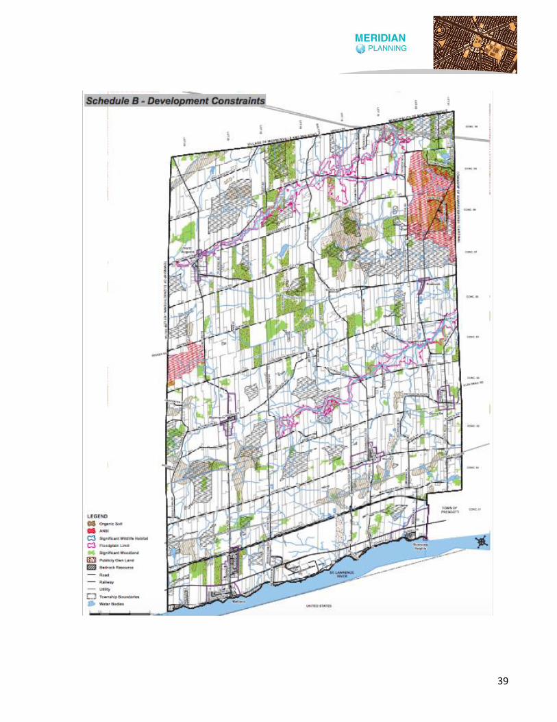
39
40
A new operation on any lands that are not
designated Mineral Aggregate Resource
Policy Area requires an amendment to the
Official Plan.
Section 5.2.4 of the Augusta OP includes
policies that apply to areas identified as
Bedrock Resource. Section 5.2.4.1 states
that areas of potential bedrock resources are
identified as Bedrock Resource on Schedule
B as a constraint overlay. Section 5.2.4.2
requires an amendment to the Official Plan
to establish a mineral aggregate operation
on lands within these areas.
In addition to the above, Section 5.2.5 of the
Augusta OP establishes other policies that
apply to lands within areas identified as
Bedrock Resource as well as those that are
considered to be adjacent lands. In this
regard, Section 5.2.5.1 reads as follows:
In areas located within 300 metres of a
Mineral Aggregate Resource Policy Area
intended or utilized for a licensed pit
operation and 500 metres from a Mineral
Aggregate Resource Policy Area intended or
utilized for a licensed quarry operation,
incompatible development, including the
creation of new lots shall only be permitted
subject to the following criteria:
The criteria referenced in Section 5.2.5.1 is
identified in Sections 5.2.5.2 and 5.2.5.3
below:
Hydrogeological investigations conducted by
a qualified professional conclusively
demonstrate that the proposed non
extraction development can be adequately
serviced by water and sewer services in a
manner which will not impede continued
existing and proposed extraction operations.
Any other investigation as required by the
development approval authority such as
traffic studies, noise studies, vibration
studies, slope stability studies, air quality
impact studies and land use compatibility
studies, etc. are carried out and demonstrate
that the proposed development can proceed
without impeding the continued operation of
the licensed extraction operation existing
licensed operations and future operations on
reserves. Such studies are to be carried out
by qualified professionals.
On the basis of the above, the influence area
for a pit is 300 metres and the influence area
for a quarry is 500 metres. AS noted above,
Section 5.2.5.2 and 5.2.5.3 of the Augusta OP
set out the required studies to support
development within the established
influence areas.
Section 5.2.6 of the Augusta OP permits
mineral aggregate resource extraction
within the Prime Agricultural Area as an
interim use provided that rehabilitation of
the site is carried out substantially in the
41
same area and the same average soil quality
for agriculture is restored.
Section 5.2.7 of the Augusta OP restricts
mineral aggregate resource extraction from
occurring within significant woodlands,
unless it can be demonstrated through an
Environmental Impact Statement and Land
Use Compatibility Study that an aggregate
extraction operation is justified. In this
regard, the cutting of woodlands to facilitate
extraction is permitted provided that there is
minimal woodland loss and that the
extraction area is progressively rehabilitated
to woodland use during and following
aggregate removal.
5.3 Township of Edwardsburgh
Cardinal
The Township of Edwardsburgh Cardinal
Official Plan (‘Edwardsburgh Cardinal OP’)
came into effect in November 2019. The
Edwardsburgh Cardinal OP includes a
Mineral Aggregate Resource Policy Area
designation on Schedule A: Land Use and
Transportation Map. This designation
applies to pits and quarries that have been
licensed under the Aggregate Resources Act
as well as known areas of mineral aggregate
resources.
In addition to the above, the Edwardsburgh-
Cardinal OP identifies Bedrock Resource and
Sand and Gravel Resource on Schedule B –
Development Constraints Map. Schedule B
also identifies significant woodlands,
significant wildlife, ANSI, flood plain, organic
soil, abandoned mines, waste disposals
(open and closed), extreme wildland fire
potential, high wildland fire potential, intake
protection zones and wellhead protection
zones. Schedule B from the Edwardsburgh
Cardinal OP is shown on the next page,
where areas of Sand and Gravel Resource
are shown as orange, hatched lines and
areas of Bedrock Resource are shown as red,
hatched lines.
Section 3.6 of the Edwardsburgh Cardinal OP
includes policies that apply to the Mineral
Aggregate Resource Policy Area designation.
In the introductory paragraphs of Section 3.6,
it is indicated that:
The Township contains considerable areas of
surficial sand and gravel resource, as well as
areas of bedrock resource. On the basis of
the Aggregate Resources Inventory of the
United Counties of Leeds & Grenville,
Southern Ontario, Paper 183 (2009), surficial
deposits that are categorized as being of
tertiary significance predominate
throughout the Township, while surficial
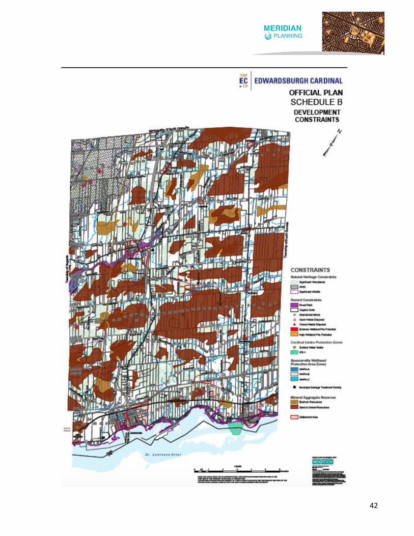
42

43
deposits of secondary significance are
exceedingly limited in extent. Bedrock
resources are expansive throughout the
Township and could play an important role in
the supply of bedrock-derived aggregates
where suitable resources exist and access to
the resource is feasible.
Many of the areas of tertiary deposits are
small and fragmented, and others are
significantly larger and/or represent areas
where deposits are concentrated. Given that
the sand and gravel resources are primarily
of tertiary significance and many are small
and fragmented, it is recognized that not all
deposits are suitable to support commercial
activity for aggregate extraction. Similarly,
not all bedrock resources may be suitable to
support commercial activity.
In addition to the above, it is also stated
within this section that:
Areas of potential surficial and gravel
resources and areas of potential bedrock
resources are identified as mineral
aggregate reserves on Schedule B. In certain
cases, these resources have been excluded
from Schedule B due to contextual
considerations such as proximity to
provincially significant wetlands and/or
incompatible land uses such as settlement
areas and other built up areas.
The policy above indicates that a scoping
exercise was undertaken to delineate both
the sand and gravel and bedrock resources
within the Township, however it is not clear
what buffers were applied in the refinement
process.
In addition to the above, the final
introductory paragraph recognizes that an
amendment may be required to implement
the UCLG ARMP once it is completed and
that this may include designating additional
lands on Schedule A as Mineral Aggregate
Resource Area, refining the extent of mineral
aggregate reserves identified on Schedule B
and the inclusion of additional mineral
aggregate policies.
Section 3.6.2.1 of the Edwardsburgh
Cardinal OP establishes the permitted uses
for the Mineral Aggregate Resource Policy
Area designation and these include:
• Pits and quarries;
• Wayside pits and quarries;
• Portable asphalt plants and concrete
plants;
• Agricultural uses, excluding any
accessory building or structure;
• Conservation and natural resource
management uses, excluding any
accessory building or structure;
• Uses accessory to an aggregate
extraction operation, such as crushing
44
and screening operations, machinery
storage facilities and office space; and,
• Permanent asphalt and concrete plants,
subject to a zoning by-law amendment.
In addition to the above, Section 3.5.3.3
permits extraction within the Agricultural
Resource Policy Area designation as an
interim use provided that the site will be
rehabilitated back to an agricultural
condition.
Section 3.6.3 of the Edwardsburgh Cardinal
OP includes policies that apply to lands
within the Mineral Resource Policy Area
designation. The establishment of new
licensed operations or the enlargement of an
existing licensed operation is permitted by
the Official Plan provided that the new area
or enlargement area is located entirely
within the designated area. This section of
the Official Plan also includes a list of the
types of studies that are required to support
new or expanded operations beyond the
Mineral Resource Policy Area designation. It
is noted, however, that Section 3.6.3.8
requires an Official Plan Amendment for the
establishment of a mineral aggregate
operation within lands identified as Mineral
Aggregate Reserve on Schedule B. Lands
within the Mineral Aggregate Reserve
include Bedrock Resource and Sand and
Gravel Resource areas.
In addition to the above, Section 3.6.3.9 of
the Edwardsburgh Cardinal OP establishes
the influence area for pits and quarries and
it reads as follows:
It is a policy of this Plan that existing sensitive
land uses such as residences, day care
centres and educational and health facilities
shall be protected from the establishment of
new mineral aggregate operations or
expansions where such establishment or
expansion would be incompatible for reasons
of public health, public safety or
environmental impact. Similarly, established
pits and quarries and resource areas are the
beneficiaries of reciprocal policies contained
in the Land Use Compatibility section of this
Plan intended to protect them from
encroachment by sensitive land uses.
Influence areas in relation to pits are 300
metres, except in the case of Class B pits
where excavation is above the water table, in
which case the influence area is 150 metres.
The influence area in relation to quarries is
500 metres.
On the basis of the above, the influence area
for a pit is 300 metres, unless the pit is a Class
B pit with excavation above the water table
then the influence area is 150 metres. The
influence area for a quarry is 500 metres.

45
5.4 Township of Elizabethtown-
Kitley
On July 16, 2018, the Council for the
Township of Elizabethtown-Kitley adopted
its Official Plan (‘Elizabethtown-Kitley OP’)
and it was approved by the UCLG on October
25, 2018. The Elizabethtown-Kitley OP
includes a Mineral Resource designation and
it is identified on Schedule A1 – Land Use and
Roads, Schedule A2 – Land Use and Roads
North and Schedule A3 – Land Use and Roads
South. The intent of the Mineral Resource
designation is to recognize existing
resources as well as pits and quarries. The
Mineral Resource designation includes two
subcategories ‘ – Mineral’ and ‘– Mineral
Aggregate’.
Section 3.3.1 of the Elizabethtown-Kitley OP
indicates that the surficial sand and gravel
deposits in the Township are of tertiary
significance. There are no deposits of
primary or secondary significance within the
Township. It is noted in the introductory
paragraphs that:
In certain cases, areas of surficial tertiary
deposits have been excluded from the
Mineral Resource designation due to
contextual considerations such as proximity
to natural heritage features such as wetlands,
ANSIs, existing incompatible land uses or the
shorelines or water bodies.
It is anticipated that an Official Plan
amendment will be necessary to identify
both surficial and bedrock sources of
aggregate in the Township upon completion
of the Counties’ Aggregate Resource Master
Plan.
On the basis of the above, the policy above
indicates that a scoping exercise was
undertaken to delineate the sand and gravel
resources within the Township, however it is
not clear what buffers were applied in the
refinement process.
The Elizabethtown-Kitley OP recognizes that
bedrock resources are not shown on any
schedule in the Official Plan. It is further
noted within the introductory paragraphs of
Section 3.3.1 that as surficial aggregate
resources are exhausted, bedrock resources
may become of interest and that
amendment to the Official Plan will be
required to establish an operation within a
bedrock resource area. It is further
recognized that the Elizabethtown-Kitley OP
will need to be amended to identify both
surficial and bedrock sources of aggregate
upon completion of the UCLG ARMP.
On lands within the current Mineral
Resource designation, Section 3.3.2 of the
Elizabethtown-Kitley OP permits aggregate-
related and mineral-related uses as well as
agriculture forestry, conservation and
outdoor recreation uses provided that such

46
uses do not include buildings and would not
preclude or hinder the establishment of a
new mineral mining or mineral aggregate
operation or access to mineral resources.
Section 3.3.3 of the Elizabethtown-Kitley OP
includes policies that apply to the Mineral
Resource designation. In this regard, Section
3.3.3.1 requires an amendment to the
Official Plan for any expansion proposal that
extends onto lands that are beyond the
limits of the designated area. Additional
subsections within Section 3.3.3 include
policies that outline required studies and
tests for alternative land uses as well as
rehabilitation requirements.
In addition to the above, Section 3.3.3.12 of
the Elizabethtown-Kitley OP establishes
influence areas and it reads as follows:
It is a policy of this Plan that existing sensitive
land uses such as residences, day care
centres and educational and health facilities
shall be protected from the establishment of
new mineral aggregate and mining
operations or expansions where such
establishment or expansion would be
incompatible for reasons of public health,
public safety or environmental impact.
Similarly, established pits and quarries and
resource areas are the beneficiaries of
reciprocal policies contained in the Land Use
Compatibility section of this Plan intended to
protect them from encroachment by
sensitive land uses. Influence areas in
relation to pits are 300 metres, except in the
case of Class B pits where excavation is
above the water table, in which case the
influence area is 150 metres. The influence
area in relation to quarries is 500 metres.
On the basis of the above, the influence area
for a pit is 300 metres, unless the pit is a Class
B pit with excavation above the water table
then the influence area is 150 metres. The
influence area for a quarry is 500 metres.
5.5 Township of Front of Yonge
On January 15, 2018, the Council for the
Township of Front of Yonge adopted its
Official Plan (‘Front of Yonge OP’) and it was
later approved by the UCLG on March 22,
2018. The Front of Yonge OP includes a
Mineral Resource designation on Schedule
A: Land Use and Roads. This designation
applies to licensed pits and quarries (also
shown on Schedule A) as well as lands
containing deposits of mineral aggregates or
minerals. Section 3.2.1 of the Front of Yonge
OP indicates that lands within this
designation are based on information from
the Ministry of Northern Development and
Mines and the Ministry of Natural Resources
and Forestry.
With respect to the mapping of aggregate
resources, the introductory paragraphs in
Section 3.2.1 of the Front of Yonge OP
indicates the following:

47
In general, the Township’s natural granular
material is virtually depleted. Portions of the
remaining surficial reserves are limited in
quality and quantity, and are inaccessible
due to contextual considerations such as
existing incompatible land uses that would
make extraction problematic. As a
consequence, surficial mineral aggregate
deposits, designated as Mineral Resource –
Aggregate, are in limited supply throughout
the Township. It is recognized, however, that
due to a lack of adequate mapping, the
Township’s relatively significant bedrock
resources of aggregate are not shown on
Schedule A. Accordingly, as surficial
aggregate resources within and adjacent to
the Township are exhausted, bedrock
sources may become of interest. In the
meantime, Official Plan Amendment
applications to develop these bedrock
aggregate resources may, therefore, be
expected. This Plan may also be amended to
identify additional mineral aggregate areas
upon completion of the Counties’ Aggregate
Resources Master Plan.
On the basis of the above, the Front of Yonge
OP recognizes that there are significant
bedrock resources within the Township that
are not identified on a map and indicates
that the Official Plan may be amended to
identify bedrock resources on an Official
Plan schedule following the completion of
the UCLG’s ARMP.
On lands designated Mineral Resource,
Section 3.2.2 of the Front of Yonge OP
permits aggregate-related uses such as pits
and quarries and associated uses as well as
agriculture, forestry, conservation and
outdoor recreation provided that such uses
do not include buildings and would not
preclude or hinder the establishment of a
new mineral mining or mineral aggregate
operation or access to mineral resources.
Section 3.2.3 of the Front of Yonge OP
includes policies that apply to the Mineral
Resource designation. Section 3.2.3.8
requires an Official Plan Amendment for any
new aggregate resource operations or any
expansions to an existing mineral aggregate
resource operation that extends beyond the
licensed boundary that is identified within
the Official Plan.
In addition to the above, Section 3.2.3.13 of
the Front of Yonge OP establishes influence
areas for pits and quarries and it reads as
follows:
It is a policy of this Plan that existing sensitive
land uses such as residences, day care
centres and educational and health facilities
shall be protected from the establishment of
new mineral aggregate and mining
operations or expansions where such
establishment or expansion would be
incompatible for reasons of public health,
48
public safety or environmental impact.
Similarly, established pits and quarries and
resource areas are the beneficiaries of
reciprocal policies contained in the Land Use
Compatibility section of this Plan intended to
protect them from encroachment by
sensitive land uses. Influence areas in
relation to pits are 300 metres, except in the
case of Class B pits where excavation is
above the water table, in which case the
influence area is 150 metres. The influence
area in relation to quarries is 500 metres.
On the basis of the above, the influence area
for a pit is 300 metres, unless the pit is a Class
B pit with excavation above the water table
then the influence area is 150 metres. The
influence area for a quarry is 500 metres.
5.6 Township of Leeds and the
Thousand Islands
On September 10, 2018, the Council for the
Township of Leeds and the Thousand Islands
adopted its Official Plan (‘Leeds and the
Thousand Islands OP’) and it was later
approved by the UCLG on November 22,
2018. The Leeds and the Thousand Islands
OP includes a Mineral Aggregate Resources
designation on Schedule A4: Land Use
Designations: Mineral Aggregate Resources,
Mineral Resources and Abandoned Mines.
Schedule A4 of the Leeds and the Thousand
Islands OP is included on the next page and
it shows sand and gravel resources in red,
existing sand and gravel pits in green
hatching and bedrock quarries in purple.
Section 5.4.1 of the Leeds and the Thousand
Islands OP includes policies that apply to
mineral aggregate resources. The
introductory paragraphs in this section
indicate that:
The Township is characterized by a
predominant pattern of Precambrian rock
knobs made up of granite and other rock
types interspersed with clay flats left
primarily by the Glacial Lake Iroquois. The
southern exposure of the Canadian Shield is
present in most of the Township underlying
the more recent deposits as a potential
source of building and monument
(dimension stone) stone. A limited amount of
sand and gravel is also present, left by glacial
activity.
The northeast corner of the Township lies
outside of the Canadian Shield in the
physiographic region known as the Smiths
Falls Limestone Plain. This area has potential
for quarrying of mineral aggregate but no
detailed study of the resource has been
completed, therefore no lands are
designated. Proposed mineral aggregate
quarries will require amendments to the
Official Plan and Zoning By-law.
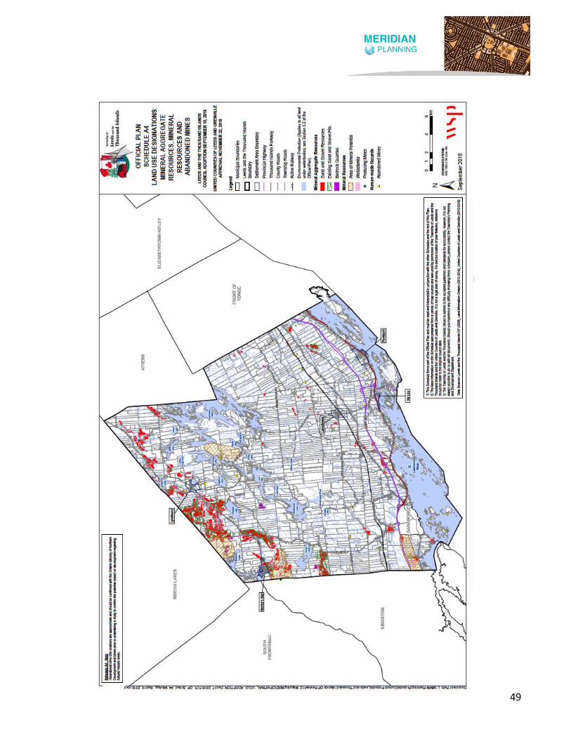
49

50
On the basis of the above, it is clear in the
above-mentioned policy that there may be
potential for quarrying of mineral aggregate
in the northeast corner of the Township,
however no detailed study of the resource
has been completed and there are no lands
designated as mineral aggregate in this area
on Schedule A4 of the Thousand Islands OP.
In this regard, any proposed quarry in this
area will require an Official Plan Amendment
and Zoning By-law Amendment.
Section 5.4.1 of the Leeds and the Thousand
Islands OP sets out the permitted uses within
the Mineral Aggregate Resources
designation and these include extractive
operations, associated aggregate uses,
agriculture, forestry, conservation or passive
recreation which do not preclude or hinder
current or future extraction of the resource.
Existing dwellings and accessory uses may
also be permitted as legal non-conforming
uses and may be expanded or new accessory
uses permitted where Council determines
that such an expansion or accessory use
does not hinder access to the resource or the
continued operation of pits and quarries.
Section 5.4.1.1.1 of the Leeds and the
Thousand Islands OP includes policies that
apply to mineral aggregate resources as well
as sand and gravel resources. It is noted
within this section that Schedule A4
identifies those sand and gravel resources
that are not yet sterilized as well as other
licensed areas. Interim land uses such as
agriculture, forestry and outdoor recreation
uses may be permitted provided that these
do not include buildings or activities that
would preclude the establishment of a pit.
However, in areas of existing agricultural
operations, buildings and structures
accessory to an agricultural operation may
be permitted.
In addition to the above, Section 5.4.1.1.3 of
the Leeds and the Thousand Islands OP
includes a policy that establishes influence
areas and it reads as follows:
The concept of an influence area is
recognized as a means of protecting against
incompatible land uses in the vicinity of
existing and proposed pits and quarries. This
influence area can be considered a study
area in which studies may be completed by
the proponent to demonstrate that the
proposed pit or quarry is compatible with
land uses within the influence area. This
influence area is applied reciprocally to
sensitive land uses encroaching upon existing
pits and quarries.
The Ministry of the Environment,
Conservation and Parks recommends an
influence area of 500 metres for quarries,
150 metres for sand and gravel pits or
reserves above the groundwater table, and
300 metres for sand and gravel pits or
reserves below the groundwater table.
51
Development within this influence area may
be permitted if impacts such as noise, dust,
and vibration can be mitigated.
On the basis of the above, the influence area
for a pit is 300 metres, unless the pit is a Class
B pit with excavation above the water table
then the influence area is 150 metres. The
influence area for a quarry is 500 metres.
Section 5.4.1.2 of the Leeds and the
Thousand Islands OP includes policies that
apply to bedrock resources. In this regard,
the only policy within this section reads as
follows:
The majority of the Township has bedrock
resource areas. The location and extent of
the bedrock resource areas shall be
determined through the Counties’
preparation of an Aggregate Resources
Master Plan, in consultation with the
Province, local municipalities including the
Township, and stakeholders.
On the basis of the above, the Leeds and the
Thousand Islands OP does not recognize
bedrock resources and indicates that the
location and extent of bedrock resources will
be identified in the UCLG ARMP.
5.7 Village of Merrickville-
Wolford
On February 10, 2020, the Council for the
Village of Merrickville-Wolford adopted the
Official Plan (‘Merrickville-Wolford OP’). The
Merrickville-Wolford OP includes an
Aggregate Resource designation on
Schedule A: Land Use Plan. This designation
is intended to recognize existing pits and
quarries within the Village. It also identifies
areas where primary, secondary and tertiary
surficial deposits of sand and gravel
resources are located. These deposits are
found throughout the Village in a number of
areas.
Section 6.3.4.1 of the Merrickville-Wolford
OP also indicates that there are no bedrock
resources identified on a schedule in the
Official Plan. In this regard, the Official Plan
recognizes that an amendment will be
required to implement the UCLG ARMP once
it is completed.
Section 6.3.4 of the Merrickville-Wolford OP
includes policies that apply to aggregate
resources and requires an amendment to
the Official Plan to permit a new pit or quarry.
Section 6.3.4.2 addresses permitted uses
within the Aggregate Resource designation
and it reads as follows:
The permitted uses include aggregate
extraction by means of pits and quarries as
defined in the Aggregate Resources Act, as
well as associated uses such as aggregate
storage, stone crushing plants, concrete
batching plants, asphalt batching plants and

52
accessory uses. Forestry, open air recreation
and agriculture are also permitted uses.
In addition to the above, Schedule A-3:
Hazards and Constraints of the Merrickville-
Wolford OP identifies the Aggregate
Resource designation and the associated
influence area. Schedule A-3 of the Village of
Merrickville-Wolford OP is shown on the
following page and it identifies the influence
area in orange, hatched lines. It is noted that
the white area within each influence area are
the lands that are designated Aggregate
Resource in the Merrickville-Wolford OP.
Section 5.6 of the Merrickville-Wolford OP
includes policies that apply to influence
areas. Section 5.6.1 indicates that Schedule
A-3 and Schedule B-3 identify influence
areas adjacent to certain land uses where
development, particularly residential
development, may be restricted or
prohibited because of potential
incompatibility with the adjacent designated
land uses. In this regard, the influence area
is 300 metres for a pit and 500 metres for a
quarry.
In addition to the above, Section 5.6.2 of the
Merrickville-Wolford OP establishes the type
of development that is permitted within
influence areas and it reads as follows:
Development may be permitted within the
Influence Areas in accordance with the
policies of the underlying land use
designation and in accordance with any
applicable policies of the adjacent land use
designation to which the Influence Area
applies, subject to the following additional
policies.
1. Residential and other sensitive land
uses are generally prohibited, but
may be permitted in consultation
with the public agency having an
interest in the Influence Area.
2. Prior to approving any development
within the Influence Areas, Council
shall require the applicant to
undertake a study in order to identify
the impact of the proposed
development on the adjacent
designated land use, and vice versa.
The study shall also identify what
measures can be undertaken to
mitigate the impact. Any such study
shall be undertaken to the
satisfaction of the Village and in
accordance with the requirements of
the public agency having an interest
in the Influence Area.
3. Where the designated land use
ceases operation, either by the
closing of a waste disposal site or
salvage yard, or

53
54
4. the surrendering of a license to
operate a pit or quarry, the policies of
this Section will continue to apply to
the extent that the study referred to
above shall be required, with
necessary modifications, prior to the
approval of any development.
5.8 Municipality of North
Grenville
On May 14, 2018, the Council for the
Municipality of North Grenville adopted its
Official Plan (‘North Grenville OP’) and it was
approved by the UCLG on November 22,
2018. The North Grenville OP indicates that
the North Grenville area contains extensive
sand and gravel deposits that provide a
valuable source of road and building
construction material. The North Grenville
OP includes a Mineral Aggregate designation
that applies to licensed operations as well as
reserves of sand, gravel and limestone. It is
noted in the introductory paragraphs in
Section 7 of the North Grenville OP that the
lands currently designated as Mineral
Aggregate are the result of a scoping
exercise that was undertaken with the
Ministry of Natural Resources and Forestry,
which reads as follows:
The Municipality, in consultation with the
Ministry of Natural Resources and Forestry,
has undertaken a scoping exercise regarding
mineral aggregate resources as part of this
Official Plan. However, the Municipality
acknowledges that a Counties’ Aggregate
Resources Master Plan will be carried out by
the Counties in consultation with local
municipalities within 3 years of approval of
the Counties’ Official Plan. Furthermore, this
exercise will consider available mapping,
potential constraints to resource extraction,
and the associated policy framework, which
may identify the criteria that should be
considered as part of any Aggregate
Resources Master Plan.
On the basis of the above, the policy above
indicates that a scoping exercise was
undertaken to delineate the sand and gravel
and bedrock resources within the Township,
however it is not clear what buffers were
applied in the refinement process.
Schedule A to the North Grenville OP
identifies the lands that are within the
Mineral Aggregate designation. Section 7.1
of the North Grenville OP sets out the
permitted uses for this designation which
include aggregate-related uses as well as
interim land uses such as agriculture,
forestry and outdoor recreation provided
that these uses do not include buildings or
activities which would preclude the
establishment of a pit or quarry.
Section 7.2 of the North Grenville OP
includes policies that apply to the Mineral
Aggregate designation. Subsection a)

55
indicates that any proposal to expand
beyond the limits of the designation requires
an amendment to the Official Plan.
Subsections b) and c) apply to influence
areas and they read as follows:
b) The concept of an influence area is
recognized as a means of protecting against
incompatible land uses in the vicinity of
Mineral Aggregate areas and to protect
existing pits and quarries from
encroachment from other incompatible land
uses. In accordance with this concept, it will
be the policy of the Municipality to
discourage incompatible land uses in areas
surrounding Mineral Aggregate areas by
careful review of any severance application,
rezoning application or other development
proposal in consultation with the
appropriate government agency. This area of
influence is generally 150 metres for a pit
above the water table, 300 metres for a pit
below the water table and 500 metres for a
quarry from the boundary of an area licensed
through the Aggregate Resources Act. In
these areas, development which would
preclude or hinder the establishment of new
operations or access to the resources will
only be permitted if:
i. resource use would not be feasible; or
ii. the proposed land uses or
development serves a greater long
term public interest; and
iii. issues of public health, public safety
and environmental impact are
addressed.
c) For proposed development within
influence areas, studies may be required by
the Municipality to determine whether
development would preclude or hinder the
establishment of new operations or access to
the resources. These studies may include
noise assessments, hydrogeology reports
and other similar studies.
On the basis of the above, the influence area
for a pit above the water table is 150 metres
and a pit below the water table is 300 metres.
The influence area for a quarry is 500 metres.
In addition to the above, Section 7.2 n) also
states that bedrock resources are identified
on Schedule A of the North Grenville OP. The
establishment of a mineral aggregate
operation on lands identified as bedrock
resource requires an Official Plan
Amendment and the influence area of 500
metres applies. This subsection also
recognizes that the UCLG will complete an
ARMP that may require amendments to the
North Grenville OP to implement new
and/or updated mineral aggregate resource
mapping and policies.
5.9 Township of Rideau Lakes
On October 20, 2003, the Council for the
Township of Rideau Lakes adopted its

56
Official Plan (‘Rideau Lakes OP’) and it was
approved by the MMAH, with modifications,
on April 2, 2004. The Township is currently
undertaking an Official Plan update
according to its website. A draft Official Plan,
dated February 10, 2021, is currently
available for review. It is noted that the
policies in the February 2021 draft Official
Plan for mineral aggregate resources have
been enhanced to include policies that apply
to minerals and other policy language that
implements the current PPS.
The Rideau Lakes OP includes a map of each
Township ward and each includes the
Mineral Resource designation. Section 3.3 of
the Rideau Lakes OP indicates that the
designation reflects the extent of resources
and existing operations and is based on
information provided by the MNRF and the
MNDM. It is further noted that:
In certain cases, areas having mineral
aggregate or mineral potential have been
excluded from the Mineral Resource
designation due to contextual considerations
such as proximity to natural heritage
features such as wetlands and ANSIs,
existing incompatible land uses or the
shorelines of water bodies.
On the basis of the above, the policy above
indicates that a scoping exercise was
undertaken to delineate the sand and gravel
and bedrock resources within the Township,
however it is not clear what buffers were
applied in the refinement process.
Section 3.3.2 of the Rideau Lakes OP permits
a number of uses in the Mineral Resource
designation such as aggregate-related uses,
mineral-related uses, agriculture, forestry,
conservation and outdoor recreation as long
as such uses do not generally include
buildings or activities that would preclude or
hinder the establishment of new aggregate
operations.
In addition to the above, Section 3.3.3 of the
Rideau Lakes OP includes policies that apply
to lands within the Mineral Resource
designation. In this regard, Section 3.3.3.2
indicates that new operations, as well as
expansions to existing operations will be
established through an amendment to the
Zoning By-law and also may require other
studies to support the proposal.
Section 3.3.3.3 of the Rideau Lakes OP
establishes influence areas and it reads as
follows:
Lands within the Mineral Resource
designation that are not zoned for mineral
aggregate or mineral mining operations shall
be placed in an appropriate zone category in
the Zoning By-law which will allow rurally-
oriented uses, but which will not allow
sensitive land uses such as residences, day
care centres and educational and health

57
facilities within the influence area of existing
mineral aggregate and mining operations.
Influence areas in relation to pits are 150 or
300 metres, depending upon the licence
classification of the pit, as well as whether
the pit excavation extends above or below
the water table. The influence area in
relation to quarries is 500 metres.
On the basis of the above, the influence area
for a pit depends on the license classification
but it is either 150 metres or 300 metres. The
influence area for a quarry is 500 metres.
5.10 Village of Westport
The Council for the Village of Westport
adopted its Official Plan (‘Westport OP’) in
March 2006 and it was approved, with
modifications, by the MMAH on October 31,
2006. While there are no mineral aggregates
within the boundaries of the Village, there is
a quarry on lands adjacent to the Village. In
this regard, the Westport OP includes a
policy in Section 3.15 that applies to lands
that are adjacent to the western boundary of
the Village and reads as follows:
Although not within the boundaries of the
Village, the Ministry of Natural Resources
has indicated that currently there are two
separate licensed quarries in the Township of
Rideau Lakes. Therefore any development
proposed within 50 metres of the western
edge of the Village boundary, which is within
500 metres of a licensed quarry, will only be
considered if it is supported by a
compatibility study, undertaken by a
qualified expert, which demonstrates that
continued use of the mineral aggregate
operation will not be precluded or hindered
as a result of the proposed development.
Implementation of this policy will require
contact with the Township of Rideau Lakes.
Current information with respect to the
status and location of licensed mineral
aggregate operations and technical advice in
the preparation of the terms of reference for
a compatibility study can be obtained from
the Ministry of Natural Resources.
On the basis of the above, lands along the
western edge of the Village boundary are
within the 500 metre influence area of a
licensed quarry and are required to submit a
compatibility study to demonstrate that the
continued use of the existing mineral
aggregate operation will not be impacted.
5.11 Summary of Mapping in
the Lower-Tier Official Plans
Section 3.5.2 e) of the Counties OP enables
lower-tier municipalities to refine the
mapped boundaries of sand and gravel and
bedrock resource areas in their respective
Official Plans without an amendment to the
Counties OP, until such time that the UCLG
completes the ARMP. For ease of reference,
Section 3.5.2 e) has been reproduced below.

58
3.5.2 e) Until such time that an Aggregate
Resources Master Plan has been prepared
and implemented through an amendment to
the Counties Official Plan, local
municipalities in their local municipal Official
Plans may adjust or refine the extent of the
sand and gravel resource areas identified on
Schedule B and the bedrock resource areas
identified by the Province, and the extent to
which the policies associated with deposits of
mineral aggregate resources apply within
these areas, without an amendment to the
Counties Official Plan. Refinements or
adjustments to the extent of the sand and
gravel resource areas and the bedrock
resource areas may be based on the
consideration of the viability of the local
resources, the location of settlement areas
and existing development, the location of
natural heritage features and areas, and
setbacks from waterbodies, among other
matters, and will be subject to provincial
approval.
As noted above, while local refinements are
permitted in the Counties OP, Provincial
approval is still required, however, it is noted
that the Province is not the approval
authority for lower-tier Official Plans. In
addition, the wording in this policy makes it
clear that this applies until the UCLG
completes the ARMP and implements the
ARMP in the Counties OP through an Official
Plan Amendment.
On the basis of the above, the UCLG could
continue to permit the lower-tier
municipalities to complete minor
refinements to sand and gravel and bedrock
resource boundaries in the same manner
that it permits refinements to certain natural
heritage features, as established in Section
4.2 a) of the Counties OP. However, if local
refinements to sand and gravel and bedrock
resources are permitted in the Counties OP,
it should be clear in the policy framework
that such refinements are subject to a review
by the UCLG.
Sections 5.1-5.11 of this ARMP provided an
overview of the policies in the 10 lower-tier
Official Plans with respect to mineral
aggregate designations and mapping. In this
regard, 8 of the lower-tier municipalities
include a map that identifies sand and gravel
resources while only 5 of the lower-tier
municipalities include a map that identifies
bedrock resources.
In addition to the above, there are 6 lower-
tier municipalities that have completed a
scoping exercise for sand and gravel and/or
bedrock resources. Based on a review of the
lower-tier Official Plans, it is not clear exactly
which factors (e.g. extent of buffers) were
included in the scoping exercises, however
there is reference to certain types of
features being excluded (e.g. Provincially
significant wetlands).
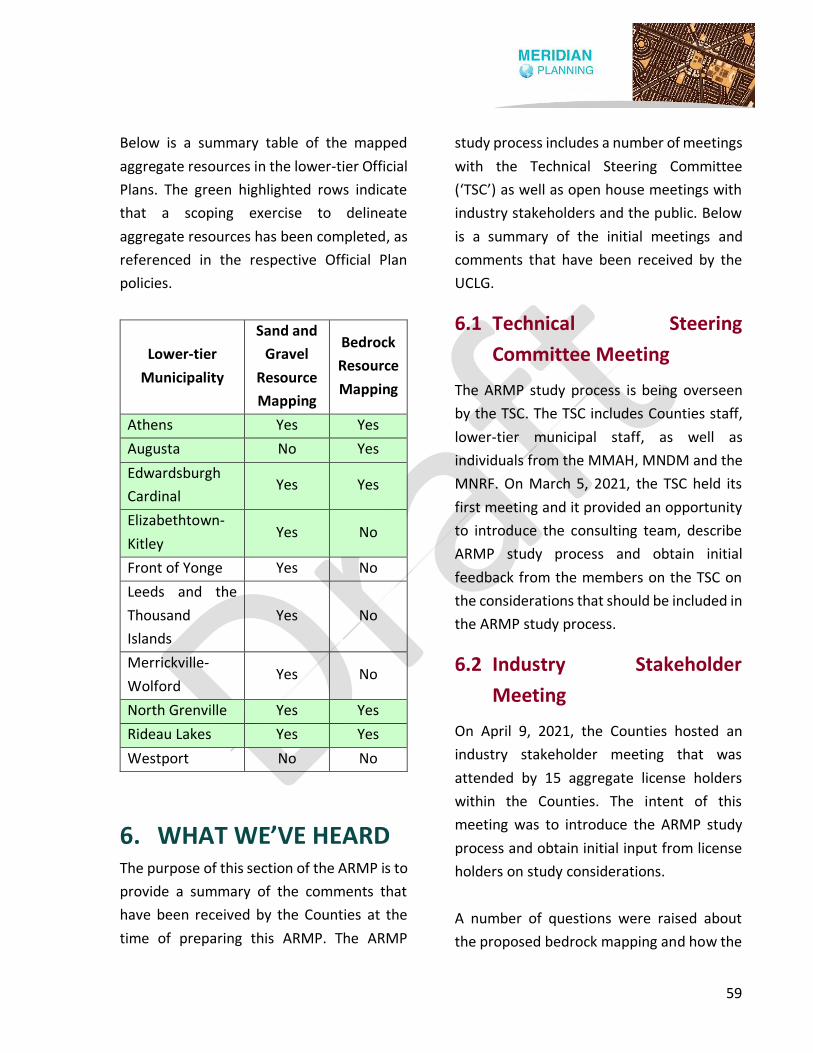
59
Below is a summary table of the mapped
aggregate resources in the lower-tier Official
Plans. The green highlighted rows indicate
that a scoping exercise to delineate
aggregate resources has been completed, as
referenced in the respective Official Plan
policies.
Lower-tier
Municipality
Sand and
Gravel
Resource
Mapping
Bedrock
Resource
Mapping
Athens Yes Yes
Augusta No Yes
Edwardsburgh
Cardinal Yes Yes
Elizabethtown-
Kitley Yes No
Front of Yonge Yes No
Leeds and the
Thousand
Islands
Yes No
Merrickville-
Wolford Yes No
North Grenville Yes Yes
Rideau Lakes Yes Yes
Westport No No
6. WHAT WE’VE HEARD The purpose of this section of the ARMP is to
provide a summary of the comments that
have been received by the Counties at the
time of preparing this ARMP. The ARMP
study process includes a number of meetings
with the Technical Steering Committee
(‘TSC’) as well as open house meetings with
industry stakeholders and the public. Below
is a summary of the initial meetings and
comments that have been received by the
UCLG.
6.1 Technical Steering
Committee Meeting
The ARMP study process is being overseen
by the TSC. The TSC includes Counties staff,
lower-tier municipal staff, as well as
individuals from the MMAH, MNDM and the
MNRF. On March 5, 2021, the TSC held its
first meeting and it provided an opportunity
to introduce the consulting team, describe
ARMP study process and obtain initial
feedback from the members on the TSC on
the considerations that should be included in
the ARMP study process.
6.2 Industry Stakeholder
Meeting
On April 9, 2021, the Counties hosted an
industry stakeholder meeting that was
attended by 15 aggregate license holders
within the Counties. The intent of this
meeting was to introduce the ARMP study
process and obtain initial input from license
holders on study considerations.
A number of questions were raised about
the proposed bedrock mapping and how the

60
bedrock boundaries are determined. In this
regard, it was noted that the Province has
mapped mineral aggregate resources (as
shown in the ARIP 183), which identifies
Selected Sand and Gravel Resource Areas
and Selected Bedrock Resource Areas. With
respect to bedrock resources, the ARIP 183
recommends that areas with a drift thickness
between 0 metres and 8 metres be identified
in an Official Plan. The proposed bedrock
mapping will implement the extent of
resources within the ARIP 183 and in
addition will also apply pre-emptive
constraints, which may exclude certain lands.
There were also comments and questions
raised about residential clusters and how
these are determined. In addition to this, it
was indicated that it would be helpful for
aggregate producers to know where these
clusters were located since aggregate
producers own many properties and
purchase properties with the intent of using
them for aggregate purposes in the future. In
this regard, it was noted that the
identification of residential clusters would
be directed to the lower-tier municipalities
and that the Counties OP would provide
direction to the lower-tier municipalities on
considerations for identifying such areas.
Comments were also raised about
rehabilitation and aggregate assessments. In
this regard, it was noted that the Counties
OP currently addresses rehabilitation and
that future policy framework would address
the requirements for aggregate assessments.
6.3 Open House Meeting
On May 31, 2021, the Counties hosted its
first Open House to discuss the ARMP. The
Counties invited 50 license holders to the
open house, along with lower-tier
municipalities, adjacent municipalities,
agencies and bodies such as cultural and
conservation representatives, utility
providers and First Nations representatives.
Public notice was also included in
newspapers, on the Counties website and
posted on social media. The Open House was
held online using the Microsoft Teams
meeting platform and there were about 20
people in attendance.
The purpose of the Open House was to
introduce the consulting team, provide a
brief overview of the current policy
framework, describe the project objectives,
discuss the next steps in the work plan and
to obtain preliminary feedback from
participants.
A number of comments were made at the
Open House on the extent of bedrock
resources and the types of features that
would be considered as pre-emptive
constraints in the proposed mapping. Those
in attendance suggested a number of
features that should be considered in the
mapping exercise such as the natural

61
heritage system, local and/or regionally
significant wetlands, forests, lands used for
maple syrup production, lands that are
classified as priority agriculture and the
Rideau Canal, which is classified as a UNESCO
World Heritage Site. It was noted that pre-
emptive constraints are used to net out
areas where aggregate extraction is unlikely
and that the intent of the mapping exercise
was to minimize the amount of areas being
removed from the mapped resources in the
ARIP 183. It was also mentioned that despite
the final mapped resources, an application
could still be made to establish a pit or
quarry.
With respect to sand and gravel resources, a
question was raised about the tertiary sand
and gravel resources. During the Counties
OP Review, the MNRF (through a comment
letter dated December 2014) strongly
recommended that primary, secondary and
tertiary sand and gravel resources be
identified on a schedule in the Counties OP.
The MNRF recommended this because of the
limited amount of sand and gravel resources
within the UCLG.
Another question was raised about how
bedrock resources will be classified within
the Counties OP. In this regard, it was noted
that a Bedrock Resource Overlay would likely
be included within the Counties OP, rather
than a land use designation. This means that
a parcel of land may have a land use
designation and be subject to the Bedrock
Resource Overlay. In this regard, any
development and/or activities in this
circumstance would be subject to the
policies of the Bedrock Resource Overlay as
well as the land use designation to
determine if development and/or activities
are permitted.
In addition to the above, there were a
number of comments made about the
mineral aggregate policy framework. In this
regard, it was suggested that the policy
framework be clear and simplistic and
reflective of the Provincial requirements to
protect aggregate resources for long-term
use. Comments were also made about there
being consideration within the policy
framework for better enabling license
expansion opportunities and when studies
and/or an assessment should or should not
be required. A comment was also raised
about specifically considering setbacks from
roadways as a pre-emptive constraint, which
would enable development along roadways.
It was also suggested that the policy
framework be tailored to address sand and
gravel resources and aggregate resources
separately.
6.4 Summary of Other
Comments
Below is a summary of the other comments
that the UCLG has received as part of the

62
ARMP study process at the time of writing
this ARMP. These comments have been
organized by the date that they were
received by the UCLG.
On February 23, 2021 staff at the MNDMNRF
provided links to a bedrock geology layer and
Paleozoic geology layers that are accessible
through the OGS. In addition, staff noted
that there may be some potential for
aggregate sources in Precambrian rocks and
further mentioned that granites and gabbro
are becoming more common sources of road
aggregate and are also being quarried for
decorative aggregate. It was also noted that
there is potential for developing sandstones,
as shown on the Paleozoic map, as both
crushed aggregate and as dimension stone.
While this information provides additional
layers to consider, only the data from the
ARIP 183 was used in delineating bedrock
and sand and gravel resources as the PPS
requires the use of this dataset.
On April 9, 2021, the MNDMNRF also
provided some initial comments to inform
the ARMP and noted their desire to see a
certain level of rigor around applying Section
2.5.2.5 of the PPS to planning applications,
including applications for severances. For
ease of reference, Section 2.5.2.5 of the PPS
has been reproduced below.
In known deposits of mineral aggregate
resources and on adjacent lands,
development and activities which would
preclude or hinder the establishment of new
operations or access to the resources shall
only be permitted if: a) resource use would
not be feasible; or b) the proposed land use
or development serves a greater long-term
public interest; and c) issues of public health,
public safety and environmental impact are
addressed.
The MNDMNRF has noted that in assessing
such applications, the quality of resource
needs to be considered in conjunction with
other constraints. The MNDMNRF also noted
that severances in resource areas could have
a significant constraining impact on the
ability to extract a mineral resource and that
the resources are non-renewable and fixed
in place.
On April 14, 2021, Tomlinson Group
(‘Tomlinson’) provided UCLG staff with their
initial comments related to the protection of
aggregate resources. Tomlinson provided an
overview of PPS policies that require the
protection of aggregate resources for long-
term use as well as the requirement of
municipalities to restrict development or
activities on lands adjacent to aggregate
resources that would preclude or hinder
extraction.
Tomlinson questioned the pre-emptive
constraints and, in particular, how
residential clusters are defined. In their

63
opinion, site-specific applications should be
the appropriate method to determine
setbacks from adjacent residential uses
rather than using constraints to remove
areas from aggregate mapping.
Tomlinson also expressed concern with the
statement that the Counties may pre-
identify uses and types of applications that
would not be subject to the preclude and
hinder policies in the PPS.
In addition to the above, Tomlinson noted
that a Counties OP Amendment should not
be required if the lower-tier municipalities
require an Official Plan Amendment and
Zoning By-law Amendment (as is the current
practice). In their opinion, requiring a
planning process at the UCLG level would
add unnecessary red tape and delay for
aggregate applications.
Lastly, Tomlinson indicated that the mapping
should not just be treated as a screening tool
when other land uses are proposed. In this
regard, Tomlinson noted that the function of
the mapping is also to protect and identify
significant aggregate resources that should
work in conjunction with the Counties OP
policies.
On May 14, 2021, Tom Graham from
Songwood Farm provided background on an
OMB Decision to remove an area behind the
Songwood Farm property from the Bedrock
Resource Overlay that was established in the
North Grenville OP. Below is a summary of
the appeal and the OMB Decision.
On May 11, 2009, the Municipality of North
Grenville adopted the North Grenville OP
and it was forwarded to the MMAH for
approval May 29, 2009. Following the
adoption and approval of the North Grenville
OP, the MNDM released ARIP 183 on June 3,
2009. In response, based on
communications between North Grenville,
the MMAH and the MNRF, North Grenville
modified Appendix A1 of the North Grenville
OP to include a Bedrock Resource Overlay
and the inclusion of policies related to
bedrock resources. On August 20, 2009, the
MMAH approved, with modifications, the
North Grenville OP and a Notice of the
Decision was issued on August 21, 2009.
Following the MMAH approval, the North
Grenville OP was appealed to the OLT on
August 31, 2009. One of the appeals was
made by Tom Graham, the owner of
Songwood Farm, on the basis that it was
inappropriate to include the lands in the
Bedrock Resource Overlay because of the
location of houses surrounding the property,
topography and the existence of an unrated
wetland.
The graphic below shows the area subject to
the appeal, otherwise referred to as the
‘Disputed Overlay’ in orange outline.
64
Staff from the MNRF and the Municipality of
North Grenville were involved in surveying
the site and agreed that the lands should not
be identified as being within the Bedrock
Resource Overlay.
On February 2, 2010, the OMB issued a
Decision to allow the appeal, in part, to the
North Grenville OP. On this basis, the
Decision modified Schedule A1 of the North
Grenville OP to remove a portion of the
Disputed Area from the Bedrock Resource
Overlay.
Below is a graphic that shows the area that
was removed from the Bedrock Resource
Overlay outlined in orange.
On May 31, 2021, Mr. James Bertram
provided the UCLG with a study prepared by
Lansink Appraisals and Consulting (‘Lansink
Report’) titled ‘Case Study Analyses:
Diminution in Price (if any) to Residential
Real Estate, Located in the Vicinity of an
Existing or Proposed Ontario Pit or Quarry’,
dated July 2013. The purpose of the Lansink
Report was to evaluate properties in
southern and eastern Ontario that are
located within the influence area of an active
or proposed pit or quarry or haul route and
to determine whether or not the presence of
an aggregate operation impacted property
value.
The study analyzed specific examples that
occurred within the open real estate market
in order to isolate the impact on property
values caused by a pit or quarry. In this
regard, the Lansink Report findings
identified 19 examples from across Ontario
(none in Leeds and Grenville) that suggested
a very high probability that there would be
price diminution if a residential property is
located within the influence of a pit, quarry
or along a haul route.
On June 18, 2021, the UCLG received a letter
from MHBC (‘Tomlinson letter’), on behalf of
Tomlinson, on the proposed aggregate
mapping. In this regard, the letter provides a
background on Tomlinson’s aggregate
production history, reviews the applicable
65
PPS policy with respect to mineral
aggregates and indicates that the proposed
aggregate mapping should not only be
viewed as a screening tool but that its
function should also be to protect and
identify significant aggregate resource areas
and be supported by Official Plan policies.
In addition to the above, the Tomlinson
letter recommends that the UCLG identify as
much of the primary, secondary and tertiary
sand and gravel resources as possible due to
the relatively limited extent of sand and
gravel resources within the UCLG. In
addition, the proposed approach of using a
cut-off of 8 metres or less is appropriate for
bedrock resources, but cautioned situations
where viable sand and gravel overlays high
quality bedrock. In these circumstances, it is
noted that the ARIP could show a greater
depth of overburden for bedrock even
though there are two viable deposits on a
site.
The Tomlinson letter suggests that further
discussion and/or evaluation is needed on
the pre-emptive constraints (e.g. defining
residential clusters) and the 500 metre
setback area from settlement areas. The
Tomlinson letter also expressed concern
with pre-identifying uses and types of
applications that do not require
consideration of the preclude and hinder
policies in the PPS.
Lastly, the Tomlinson letter recommends
that a Counties OP Amendment should not
be required for aggregate applications and
that only applications to the lower-tier
municipalities for a local Official Plan
Amendment and/or Zoning By-law
Amendment should be required to avoid
unnecessary duplication and red tape.
On June 23, 2021, the UCLG received a letter
from MHBC (‘Tackaberry letter’), on behalf
of G. Tackaberry & Sons Construction Co. Ltd.
(‘Tackaberry’), on the proposed aggregate
mapping and severance activity in rural
areas. The Tackaberry letter provides a
background on Tackaberry’s aggregate
production history, recognizes the
requirement of the PPS to identify aggregate
resources on a map and also includes a
number of concerns about the pre-emptive
constraints and severance approvals in the
area. In this regard, the Tackaberry letter
questions how residential clusters are
defined and notes that depending on how
residential clusters are defined it may
arbitrarily exclude high quality resource
areas where extraction could still be feasible.
Concerns were also raised about the 500-
metre setback from settlement areas and
whether this setback considers different
types of operations.
In addition to the above, the Tackaberry
letter recognizes that being identified on the
proposed aggregate mapping does not mean
that aggregate extraction is the only
66
permitted use or activity. In this regard, the
Tackaberry letter requests that the proposed
policy framework specifically include policies
that acknowledge that aggregate
applications outside of mapped areas are
not precluded or restricted. The Tackaberry
letter also recommends that a Counties OP
Amendment not be required for an
application for an aggregate operation.
Lastly, the Tackaberry letter noted that there
was discussion at the Open House about the
ability to continue to accommodate
severances in rural areas. Further, the
Tackaberry letter notes that they have
observed a higher level of severance activity
recently near their licensed pits and quarries
in the UCLG. The Tackaberry letter indicates
that if municipalities are determining that
such severances are appropriate and would
not preclude or hinder existing aggregate
operations then it is recommended that at a
minimum the approval be conditional on
placing a warning clause on title to ensure
that the future purchaser or landowner is
aware of the presence of a licensed
aggregate operation and mapped deposit
areas. The Tackaberry letter further requests
that the UCLG consider including this
requirement in the policy framework for the
ARMP.
7. PROPOSED MAPPING The purpose of this section of the ARMP is to
provide an overview of the factors that were
considered in developing the proposed
mapping. Appendix A to this ARMP includes
the proposed bedrock resource mapping and
Appendix B includes the proposed sand and
gravel resource mapping.
Section 2.5.1 of the PPS requires that all
Official Plans contain mapping showing the
location of deposits of mineral aggregate
resources.
It is important to note that mapping of
deposits of mineral aggregate resources are
intended to serve as a screening tool when
applications to develop other land uses are
proposed. A screening tool is a resource
used by a municipality and/or applicant to
determine which land use designations and
other land use considerations apply when a
new land use is being proposed.
In addition to the above, the mapping of
deposits of aggregate resources is also
intended to ensure that the mineral
aggregate resources are protected for long-
term use. While the area that is the site of
Selected Bedrock Resource Areas is
significant, it is important to note that it does
not establish the principle of establishing a
resource use on the lands and the same
approval process applies for new resource

67
uses regardless of location. It also does not
mean that the use of lands for a mineral
aggregate operation is a preferred land use
over other land uses provided the other land
uses do not preclude or hinder extraction.
In the case of the Counties OP (as approved
by the MMAH on February 19, 2016),
Schedule B: Mineral and Mineral Aggregate
Resources already identifies the location of
Selected Sand and Gravel Resource Areas of
primary, secondary and tertiary significance.
However, Schedule B does not include
mapping showing the location of Selected
Bedrock Resource Areas because of
concerns about the accuracy of the mapping
and the extent of the area to be included at
the time that the Counties OP was prepared.
Below is an overview of the proposed
bedrock mapping and the proposed sand
and gravel mapping.
7.1 Proposed Bedrock Mapping
The ARIP 183 includes information on the
location of Selected Bedrock Resource Areas
in the UCLG. It is noted that Aggregate
Resources of Ontario (‘ARO’) updates
aggregate mapping on an annual basis when
new information is acquired by the
MNDMNRF, such as new boreholes,
pits/quarries or other fieldwork collected
and verified by OGS staff. In this regard, the
ARO data relied upon as a base for the UCLG
ARMP identifies additional lands as Selected
Bedrock Resource Areas than the ARIP 183.
The ARIP 183 recommends that areas with a
drift thickness between 0 metres and 8
metres be identified in an Official Plan. In
this regard, any identified bedrock resources
that contain a drift thickness of greater than
8 metres, as per the ARIP 183, was not
included in the proposed bedrock mapping
for the ARMP.
As noted earlier in this ARMP, the UCLG is
underlain by Precambrian rocks, the
Cambro-Ordovician Potsdam Group and the
Ordovician March, Oxford and Gull River
Formations. Areas of the Cambro-Ordovician
Potsdam Group include the Covey Hill and
Nepean Formations, which consists of fine-
to coarse-grained quartz sandstone with
interbeds of quartz-pebble conglomerate (as
noted in the ARIP 183). With respect to these
formations in certain areas, the ARIP 183
notes the following:
Areas of the Potsdam Group have not been
identified on the map nor have drift thickness
or depth of overburden been calculated
because this group has no potential for use in
aggregate production.
On the basis of the above, these formations
are within the ARIP 183 dataset but are not
identified as being within a Selected Bedrock
Resource Area.
68
On the basis of the above, only the 7 areas
identified as Selected Bedrock Resource
Area, as identified in the ARIP 183, were
identified within the proposed bedrock
mapping.
In addition to the above, there are a number
of physical constraints that were considered
in preparing the proposed mapping and
these include:
• Provincially significant wetlands;
• Provincially significant Areas of Natural
and Scientific Interest (‘ANSI’);
• Lakes; and,
• Rivers.
The proposed mapping also took into
account buffer areas from a number of
features. In this regard, the following lands
were excluded from the proposed mapping:
• Lands within 500 metres of the
boundary of a settlement area;
• Lands within 120 metres of the
boundary of a Provincially significant
wetland;
• Lands within 120 metres of the
boundary of a Provincially significant
ANSI; and,
• Lands within 500 metres of the
boundary of lakes and rivers.
The buffer areas above are intended to be
an exclusion area, meaning that the lands
within a buffer area are not captured within
a resource area. The buffer areas are
consistent with those implemented in other
municipalities in Ontario.
Concerns have been raised about the
impacts of bedrock resource mapping on
future land use in rural areas, particularly as
it relates to rural lot creation. At the Open
House, lands within and adjacent to rural
residential clusters were identified as a
potential pre-emptive constraint. Given the
size of the UCLG, pre-identifying all of the
potential rural residential clusters for
exclusion in the Counties OP would be very
challenging and is best left to the local
municipalities, where local context can be
considered. In this regard, clusters of
development in agricultural and rural lands
designations are addressed in the proposed
policy recommendations.
7.2 Proposed Sand and Gravel
Mapping
Schedule B to the Counties OP currently
identifies primary, secondary and tertiary
Selected Sand and Gravel Resource Areas.
However, the resources on this map do not
exclude all of the physical constraints and
other buffer areas identified above in
Section 7.1 of this ARMP.
On the basis of the above, the proposed sand
and gravel mapping modifies the existing

69
Selected Sand and Gravel Resource Areas as
shown on Schedule B to the Counties OP as
they relate to Provincially significant
wetlands, ANSI’s, lakes, rivers and
settlement areas in the same manner as
described in Section 7.1 as it relates to
Selected Bedrock Resource Areas.
8. OFFICIAL PLAN
RECOMMENDATIONS The purpose of this section of the ARMP is to
provide a number of proposed policy
recommendations and the rationale behind
the proposed policies.
According to the proposed Appendix A to
this ARMP, significant amounts of land are
identified as being the site of Selected
Bedrock Resource Areas in particular and
concerns have been expressed about the
implications of including so much land in this
category on the potential for future
development.
When Selected Bedrock Resource Areas are
identified in an Official Plan, Section 2.5.2.5
of the PPS is triggered and this section reads
as follows:
In known deposits of mineral aggregate
resources and on adjacent lands,
development and activities which would
preclude or hinder the establishment of new
operations or access to the resources shall
only be permitted if:
a) resource use would not be feasible; or
b) the proposed land use or development
serves a greater long-term public interest;
and
c) issues of public health, public safety and
environmental impact are addressed.
As set out in Section 2.5.2.5 of the PPS, an
assessment of the impacts of proposed
development on the feasibility of resource
extraction is required to be carried out
whenever development is proposed, with
development being defined as development
requiring a Planning Act approval. It is noted
that items a) and b) in Section 2.5.2.5 are
separated by the word “or”.
This means that a case can be made that a
proposed land use or development serves a
greater long-term public interest than a
proposed resource use even if it is
determined that resource use would be
feasible. This means that the potential exists
as part of the review of any application to
make a determination on what use is in the
greater long-term public interest to consider.
In addition to the above, it is noted that one
of the tests is: “The resource use would not
be feasible.” In this regard, the presence of a
resource is not in of itself a determinant of

70
whether it is feasible to extract. There are a
number of factors that need to be
considered to determine feasibility and
these are identified in the proposed policies.
This section includes a set of proposed
policies for the UCLG to consider. These
proposed policies were prepared as a
consequence of the discussions held with
the lower-tier municipalities, stakeholders
and the public, our experience and our
research into the approaches taken in other
municipalities. Below is a brief overview of
approaches taken in other municipalities.
In 2017, the Ministry approved an Official
Plan Amendment for the County of Lennox &
Addington (‘L&A OP’) that addressed
selected bedrock resources and
implemented the PPS 2014. In this regard,
the L&A OP identified selected sand and
gravel and bedrock resource areas on a map
and includes policies that aim to protect
mineral aggregate resource supply while
also minimizing the impacts to planning
approvals in the agricultural and rural areas.
The policies implement the preclude and
hinder tests as required by the PPS and also
include a number of exemptions from the
preclude and hinder tests. An influence area
of 300 metres from a pit or 500 metres from
a quarry is also established within the policy
framework.
In addition to the above, in 2019 the District
Municipality of Muskoka (District’) adopted
a new Official Plan ('Muskoka OP’) that also
contains policies that address sand and
gravel and bedrock resources. The Muskoka
OP identifies primary and secondary sand
and gravel resource areas however it does
not identify selected bedrock resource as the
District is underlain by Precambrian gneissic
rock that exhibits wide variations in lithology
and aggregate quality. In this regard, the
Muskoka OP recognizes that there may be
local knowledge and locations of existing
quarries that may be considered by the Area
Municipalities if there is a desire to protect
local significance.
The Muskoka OP requires a land use
compatibility assessment for development
that is within 300 metres of a pit or 500
metres of a quarry.
In addition to the above, the Muskoka OP
identifies development that is exempted
from an aggregate assessment such as
development in urban centres and
community areas, rezoning applications for
development or expansions of a commercial,
industrial or recreational use in the Rural
Area or Waterfront Area designations,
adjustments of a lot line for legal or technical
reasons and any application for a minor
variance, regardless of location.

71
The Region of Halton Official Plan (‘Halton
OP’) is another example of an Official Plan
that identifies and includes policies that
apply to bedrock resources. The Halton OP
requires a proponent of any land use
changes through the Regional or Local
official plan amendments, zoning
amendments or consents to complete an
assessment if the proposed development is
within 300 metres of a pit or 500 metres of a
quarry. In this regard, there are no
exemptions to the requirement to complete
an assessment if a proposed development is
located within the influence areas identified
above. However, it is noted that the
Provincially significant wetlands and an area
around them were excluded from the
mapping in the Official Plan showing where
the resource is located. For shale resource
areas, the resource mapping also excludes
lands within 500 metres of settlement areas.
This approach was supported by the
Province.
On the basis of the above, the policies
contained in the Official Plans for Lennox and
Addington, Muskoka and Halton serve as
relevant examples for the types of policies
that could be considered by the UCLG for the
Counties OP.
On the basis of the above, the proposed
policies aim to create a balance between
protecting mineral aggregate resource areas
and at the same time minimizing the impact
of Section 2.5.2.5 of the PPS on future
Planning Act approvals in the Agricultural
Area and Rural Lands designations in the
Counties OP.
As mentioned previously in this ARMP,
Section 3.5.2 of the current Counties OP
applies to Mineral Aggregate Resources. The
proposed policies are intended to replace or
modify the policies contained in Section
3.5.2 of the Counties OP.
The Official Plan recommendations have
been divided into the following subsections:
1. Assessment Requirements;
2. Assessment Exemptions;
3. Mineral Aggregate Operations;
4. Application Requirements; and,
5. Mapping.
Below is an overview of the
recommendations for updates to the
Counties OP. Each subsection (except for
the mapping subsection) includes
recommended policy changes and clarifies
which section(s) of the Counties OP should
be retained, modified or replaced.
8.1 Assessment Requirements
The purpose of this section of the ARMP is to
provide a set of policies that address
assessment requirements for lands that are
within or adjacent to an aggregate resource
area. When development is proposed within

72
or adjacent to a resource area, an
assessment may be required to determine
whether the proposed development will
preclude or hinder the extraction of a known
aggregate resource.
This section includes a number of policies
that deal with ‘Assessment Requirements for
Development in a Mineral Aggregate
Resource Area’. These policies are intended
to replace those that are currently contained
in Sections 3.5.2 c), d) and g) of the Counties
OP. It is proposed that Sections 3.5.2 a) and
e) be updated and Sections 3.5.2 b), f) and
h) be retained. Below is a brief description of
each of the above-mentioned policies.
Section 3.5.2 a) of the Counties OP
recognizes that mineral aggregate resources
need to be protected for long term use,
references the Counties OP schedule where
these resources are identified and clarifies
that the identification of resources does not
mean that all lands will be used for aggregate
extraction.
On the basis of the above, it is recommended
that Section 3.5.2 a) be retained and
updated to indicate that bedrock resources,
in addition to sand and gravel resources, are
also shown on a Schedule to the Counties OP.
In addition, the sentence that notes that
bedrock resources will be identified in local
Official Plans should also be removed.
Section 3.5.2 b) of the Counties OP
recognizes that there is the potential for
viable deposits of mineral aggregates
beyond those that are identified in the
Counties OP. This means that an application
can be made on lands beyond those that are
identified, subject to there being sufficient
quantity and quality of the resource and
supporting studies. It is recommended that
Section 3.5.2 b) be retained.
Section 3.5.2 c) of the Counties OP indicates
that the Counties will complete an Aggregate
Resources Master Plan that will identify
resources and be implemented through an
amendment to the Counties OP. In this
regard, it is recommended that Section 3.5.2
c) be deleted in its entirety.
Section 3.5.2 d) of the Counties OP indicates
that sand and gravel and bedrock resources
will be identified in the local OPs until the
Counties complete its Aggregate Resources
Master Plan. In this regard, it is
recommended that Section 3.5.2 d) be
deleted in its entirety.
Section 3.5.2 e) of the Counties OP directs
local municipalities to identify sand and
gravel and bedrock resources in their local
OPs and permits the adjustment or
refinement of boundaries without a County
Official Plan Amendment until the time that
the Counties completes its Aggregate
Resources Master Plan. This policy also sets

73
out the considerations for making such an
adjustment and is subject to Provincial
approval. It is recommended that Section
3.5.2 e) be updated to allow for minor
adjustments or refinements to the
boundaries of sand and gravel and bedrock
resources without an amendment to the
County OP, subject to the review of the
County, instead of the Province, who are not
the approval authority for local Official Plan
Amendments.
Section 3.5.2 f) of the Counties OP requires
the completion of an assessment for
development proposals on lands within or
adjacent to a known deposit of mineral
aggregate resources. The policy clarifies that
‘adjacent to’ includes lands within 300
metres of a sand and gravel resources and
500 metres of a bedrock resource area. In
this regard, it is recommended that Section
3.5.2 f) be retained.
Section 3.5.2 g) of the Counties OP indicates
that until the Counties complete its
Aggregate Resources Master Plan, the local
municipalities may require that studies be
completed to demonstrate that proposed
development will not preclude or hinder the
establishment of a new aggregate operation.
The policy also provides for the waiving of
studies in certain land use designations. It is
recommended that Section 3.5.2 g) be
deleted in its entirety.
Section 3.5.2 h) of the Counties OP requires
that mineral aggregate resource
conservation be undertaken, including
accessory aggregate recycling facilities
within operations, where feasible. It is
recommended that Section 3.5.2 h) be
retained.
In addition to the above, below are the
proposed policies that address the
assessment requirements for development
in a mineral aggregate resource area and
adjacent lands.
Assessment Requirements for Development
in a Mineral Aggregate Resource Area and
Adjacent Lands
a) Schedule X identifies deposits of mineral
aggregate resources throughout the
Counties. However, the identification of
these deposits on Schedule X does not
necessarily mean that all areas identified
are appropriate for the development of
mineral aggregate operations, because
of natural heritage, land use
compatibility, transportation,
accessibility, quantity and/or
hydrogeological constraints nor does it
imply that the quality of the mineral
aggregate resource at any given location
is also suitable.
b) In cases where a proposed development
is not exempt from Section X of this Plan
in accordance with Sections X, X and X,
the approval authority may require
74
studies to demonstrate that the
proposed development will not preclude
or hinder current or future extraction
operations and/or access to the
resources or in the alternative that
resource use would not be feasible or
that the proposed land use or
development serves a greater long-term
public interest.
c) In addition to the above and in cases
where a proposed development is not
exempt from Section X of this Plan in
accordance with Sections X, X and X, the
approval authority may scope or waive
entirely any of the assessment
requirements in Section X if the approval
authority is satisfied that the information
is not required or not relevant to assess
an application for a proposed
development on lands that have been
identified as deposits of mineral
aggregate resources or adjacent lands.
d) The following factors shall be considered
by the approval authority, where
relevant and appropriate, in determining
whether an assessment is required in
support of an application for
development on lands that have been
identified as deposits of mineral
aggregate resources and adjacent lands
on Schedule X and the criteria to be
considered in an assessment if it is
determined to be required:
i. The nature and location of other
aggregate and non-aggregate
resource uses in the area and their
potential impact on the feasibility of
establishing a mineral aggregate
operation on the subject lands and
adjacent lands;
ii. The nature and location of the
potential land uses in the area based
on the land use policies in the local
Official Plan and zoning bylaw
particularly if the land uses have yet
to be established;
iii. The nature of the road network in the
area and its ability to potentially
accommodate mineral aggregate
operations in the future;
iv. The configuration of the parcels of
land in the area and whether the
parcels are individually or collectively
large enough and of a shape that
would support mineral aggregate
operations;
v. The depth of the overburden on the
subject lands and on adjacent lands
and whether the depth precludes the
economical extraction of the mineral
aggregate resource;
vi. The quality of the mineral aggregate
resource on the subject lands and in
the immediate area;
vii. The nature and potential impact of
natural heritage features and areas
in the immediate area on the

75
potential for mineral aggregate
operations in the area in the future;
viii. The nature and location of any
sensitive surface water and ground
water features in the area and its
impact on mineral aggregate
operations; and,
ix. The presence of significant built
heritage resources, protected
heritage properties, significant
cultural heritage landscapes and
significant archaeological resources
on the subject lands or in the
immediate area.
e) Where an assessment is determined to
be required, proponents shall submit a
mineral aggregate resources study
completed by a qualified professional to
demonstrate that the criteria of Section X
have been met. The approval authority
may look to the Province to provide
information and recommendations with
respect to proposals affecting deposits of
mineral aggregate resources. Aggregate
resource testing and statements from
local industry representatives may be
recommended to better assess the
viability of the resource.
8.2 Assessment Exemptions
The purpose of this section of the ARMP is to
clarify the types of scenarios or development
that may be exempt from an assessment
described in the proposed policies in Section
8.1.
Below are a number of proposed policies
that deal with exemptions as they relate to
clusters of development, agricultural related
development and other types of Planning
Act applications that could be exempt from
requiring an assessment as per Section
2.5.2.5 of the PPS.
Exemption #1 – Clusters of Development in
the Agricultural Area and Rural Lands
Designations
a) Any form of development within
clusters of non-agricultural
development outside of settlement
areas is exempted from Section X of
this Plan, with the determination of
where such clusters are located to be
made by the local municipalities on a
site-specific basis based on policies
contained in the municipal Official Plan.
b) Factors to consider in making a
determination on whether a cluster
exists are below:
i) For such a cluster to be a cluster,
the residential and other non-
agricultural uses in the cluster
should be predominately located
on smaller lots that do not exceed
1.0 to 2.5 hectares in size.
ii) If one or more uses inside the
cluster were located on lots that
have a considerable depth, only a
front portion of the lots would be
considered.

76
iii) Vacant and potentially
developable land within the
cluster would be included in the
cluster provided the residential
and other non-agricultural uses
are located close enough together.
iv) In no case can lands that have the
effect of extending a cluster in a
linear manner be included within
the cluster for the purposes of this
policy.
Exemption #2 – Agricultural Related
Development
The development and/or expansion of an
agricultural use, an agriculture-related use
and/or an on-farm diversified use, whether it
involves the development of buildings or
structures or not, is exempted from Section X
of this Plan, regardless of whether a Planning
Act approval is required.
Exemption #3 – Types of Planning Act
Applications
The following applications are exempted:
a) The creation of a new lot for an
agricultural use or an agriculture-
related use;
b) The creation of a lot to accommodate
an existing habitable farm dwelling
that has become surplus to a farming
operation;
c) The adjustment of a lot line for legal or
technical reasons;
d) The re-zoning of land for the
development or expansion of a
commercial, industrial or recreational
use in the Agricultural Area and Rural
Lands designations provided an
amendment to the local Official Plan is
not required and provided the use does
not include the establishment of
dwelling units or accommodation
units;
e) The expansion of a legal non-
conforming use, provided such an
expansion meets all of the other tests
in the local Official Plan; and,
f) Any application for site plan or minor
variance, regardless of location.
8.3 Mineral Aggregate
Operations
The purpose of this section of the ARMP is to
propose other policies that apply to mineral
aggregate operations. Section 3.5.2.1 of the
current Counties OP addresses ‘New or
Expanding Mineral Resource Operations’. It
is recommended that Section 3.5.2.1 a) of
the Counties OP be modified, and Section
3.5.2.1 c) be replaced with the proposed
policies below under ‘Mineral Aggregate
Operations’. In addition, it is recommended
that Sections 3.5.2.1 b), d), e) and f) of the
Counties OP be retained. Below is a brief
77
description of each of the above-mentioned
policies.
Section 3.5.2.1 a) requires a local Official
Plan Amendment for any new or expanding
mineral aggregate operations, but not a
Counties OP Amendment. In this regard, it is
recommended that Section 3.5.2.1 a) be
modified to remove references to local
Official Plan Amendments, but retain the
policy language that confirms that a Counties
OP Amendment is not required to identify
new or expanding aggregate resource
operations.
Section 3.5.2.1 b) identifies evaluative
criteria that must be met when considering
new or expanding aggregate operations and
a local Official Plan Amendment. It is
recommended that Section 3.5.2.1 b) be
retained in the Counties OP.
Section 3.5.2.1 c) enables the Counties
ARMP to consider studies that consider
potential cumulative impacts of proposed
aggregate operations on past, present and
other known mineral aggregate resource
applications in the vicinity. In this regard,
there are other proposed policies in this
section of the ARMP that deal with assessing
cumulative impacts and for this reason it is
recommended that Section 3.5.2.1 c) be
deleted in its entirety.
Section 3.5.2.1 d) requires a pre-application
consultation with the Province, Counties,
local municipality and Conservation
Authority. It is recommended that Section
3.5.2.1 d) be retained in the Counties OP.
Section 3.5.2.1 e) enables the Counties to
provide comments on an application made
under the Aggregate Resources Act if the
proposed operation does not require a
Counties or local planning approval. In this
regard, it is recommended that Section
3.5.2.1 e) be retained in the Counties OP.
In addition to the above, below are the
proposed policies that address mineral
aggregate operations.
Mineral Aggregate Operations
a) Mineral aggregate operations shall be
protected from development and
activities that would preclude or hinder
their expansion or continued use or
which would be incompatible for
reasons of public health, public safety
or environmental impact.
b) Existing mineral aggregate operations
that are licensed pursuant to the
Aggregate Resources Act shall be
permitted to continue without the
need for official plan, zoning by-law or
community planning permit
amendment under the Planning Act.
78
When a license for extraction or
operation ceases to exist, Section X of
this Plan continues to apply.
c) When considering a new mineral
aggregate operation, the co-location
or grouping of such facilities and
recycling of materials and progressive
rehabilitation should be encouraged by
the Counties and/or local municipality
to be addressed by the Provincial
approval authority.
d) Extraction shall be undertaken in a
manner which minimizes social,
economic and environmental impacts.
8.4 Application Requirements
The purpose of this section of the ARMP is to
establish a set of application requirements
that apply to new or expanding mineral
aggregate operations. It is recommended
the proposed application requirements be
included as a new sub-section within Section
3.5.2.1 in the Counties OP.
Application Requirements
Any application for an amendment to a local
Official Plan, and/or the zoning bylaw or
community planning permit by-law to
establish or expand a mineral aggregate
operation shall be supported by studies that
are based on predictable, measurable,
objective effects on people, the environment
and structures, with these studies and their
scope being identified in advance and with
regard to the scale of the proposed new
operation or expansion. Such studies shall be
based on Provincial standards, regulations
and guidelines, where they exist, and will
consider and identify methods of addressing
the anticipated impacts in the area affected
by the mineral aggregate operation.
Each local Official Plan shall contain
application requirements for this use that
require that all applications be supported by
information that address:
a) The impact of the mineral aggregate
operation on:
i) The natural heritage features
and areas and related ecological
functions on the site and in the
area;
ii) Adjacent and nearby existing or
planned land uses;
iii) Agricultural resources and
activities;
iv) The quality and quantity of
water;
v) The significant built heritage
resources, protected heritage
properties, significant cultural
heritage landscapes and
significant archaeological
resources on the site and in the
area;

79
vi) The groundwater recharge and
discharge functions on the site
and in the immediate area;
vii) Surface water features in the
area; and,
viii) Nearby wells used for drinking
water purposes.
b) The effect of the additional truck traffic
on the ability of an existing haul route
to function as a safe and efficient haul
route;
c) The suitability of any new haul routes
proposed;
d) The impact of the noise, odour, dust
and vibration generated by the
proposed operation or expansion on
adjacent land uses;
e) How the impacts from the proposed
mineral aggregate operation or
expansion on adjacent uses will be
mitigated in order to lessen those
impacts; and,
f) How the site will be progressively
rehabilitated to accommodate
subsequent land uses after the
extraction is completed, to promote
land use compatibility, to recognize the
interim nature of extraction and to
mitigate impacts to the extent possible
as required under the Aggregate
Resources Act. Final rehabilitation shall
take surrounding land uses and
approved land use designations into
consideration.
Lastly, the Counties OP also includes Section
3.5.2.2 that includes policies that apply to
rehabilitation. In this regard, it is
recommended that this section be retained
as is in the current Counties OP.
8.5 Mapping
The purpose of this section of the ARMP is to
provide direction on mapping updates
required to identify sand and gravel and
bedrock resources in the Counties OP.
Section 5 of this ARMP reviewed the lower-
tier OPs and their policy approach that
applies to mineral aggregate resources as
well as their approach to mapping mineral
aggregate resources.
On the basis of the above, several of the
lower-tier OPs identified resource areas as a
layer on a constraints schedule in their
Official Plan. In this regard, is recommended
that sand and gravel and bedrock resource
areas be identified on a map in the Counties
OP as a Potential Development Constraint
Overlay.