AGENDA SAND SPRINGS PLANNING COMMISSiON
19
AGENDA SAND SPRINGS PLANNING COMM ReguIar Meeting Monday, February 19, 2018 4:00 p.m, Sand Springs Municipai Buiiding’1OO E" Cfty Councii Chambe「s, Room 203 Commission wi= discuss and consider rec O「dinance 1312 to rezone 18.000 ac「es from (Comme「ciaI GeneraI) fo○ ○etaiI development p genera=y at 400 S" Hwy 97 in Section 141 East, Commission wilI discuss and consider re Ordinance 1313 to cIose a portion of an app「 Ut冊ty Easement, beginning 17・5, south of th BIock l, River West Addition No, 2 and 「u Iine ofしot 2, BIock 2, River West Addition the easement is so that a commerciai bui common Iot Iine. The prope巾「 is commoniy BIvd. in Section =, Township 19 North, Ran 6. Director’s Report 7, Adioumment 翰蒜y 宣b I可,2。1。,。n,h。S。∩。S。,in
Transcript of AGENDA SAND SPRINGS PLANNING COMMISSiON

AGENDA
SAND SPRINGS PLANNING COMMISSiONReguIar Meeting
Monday, February 19, 2018
4:00 p.m,
Sand Springs Municipai Buiiding’1OO E" Broadway
Cfty Councii Chambe「s, Room 203
Commission wi= discuss and consider recommendation to City CounciI
O「dinance 1312 to rezone 18.000 ac「es from iH (Indust「ial Heavy) to CG
(Comme「ciaI GeneraI) fo○ ○etaiI development pu「poses on p「Operty Iocated
genera=y at 400 S" Hwy 97 in Section 141 Township 19 North’Range =
East,
Commission wilI discuss and consider recommendation to City CounciI
Ordinance 1313 to cIose a portion of an app「oximateiy 135, Iong・ 11’wide
Ut冊ty Easement, beginning 17・5, south of the northeast come「 Of Lot 2’
BIock l, River West Addition No, 2 and 「unning adjacent to the wes=ot
Iine ofしot 2, BIock 2, River West Addition No. 3. The purpose for ciosjng
the easement is so that a commerciai building can be built across the
common Iot Iine. The prope巾「 is commoniy knowれaS 152 W・ Alexander
BIvd. in Section =, Township 19 North, Range = East.
6. Director’s Report
7, Adioumment
翰蒜y宣b I可,2。1。,。n,h。S。∩。S。,in。S

PLANNING COMMiSSIONReguiar Meeting Mi…teS
Monday, Janua「y 8, 2018
4:00p,m。
Sand Sp「ings MunicipaI BuiIding’100 E. Broadway
City Counc= Chambers, Room 203
MEIVIBERS PRESENT: Paul Shindel, Chai「man 7-O
Ha「old NeaI, VICe-Chal「man 4-3
Jason Mikies, Sec「etary 5-2
Patty DIXOn 6-1
Tom Askew 5-2
Ke「i Fothe「g川4-3
MEMBERS ABSENT: Joe SheIton 5-2
STAFF PRESENT: B「ad Bates, City Planne「
Cynthla Webste「, Reco「ding Sec「eta「y
The Sand Sp「IngS Pianning CommiSSiOn met ln 「egular sessiOn On Monday, January 8,
2018 1n the Sand Sp「lngS Mu…CIPai Bu-iding' Room 203, Pu「Suant tO the agenda flIed
With the City Cie「k’s offlCe, POSted on the dig-tai diSPIay boa「d -ocated in the fi「St fioo「
iobby of the Sand Spr-ngS MuniCiPaI Buiiding' 100 E B「oadway, Sand Sp「ingS,
Oklahomal and posted on the Clty Of Sand Sp「ingS Webs'te at WWW Sandsp「InqSOk.o「g
at8 50a m , January4, 2018 byCynth-aWebster
l, Caii to O「der
Chai「man Shindel cailed the meeting tO O「de「at the noted time Of4 01 p m
2. Roli Ca=
ChaI「man Shlndei calIed fo「 an lndIVlduai 「oii caii wIth membe「s 「epiylng ln the foiiowing
manne「 Ms DIXOn' he「e- M「 Mikies, he「e, M「 SheIton, nO 「eSPOnSe, M「 ShInde上
he「e, M「 Neai, he「eうM「 Askew. he「e, Ms Fothe「g町here
M「 Shelton was noted as absent
3. Minutes of December =’2017
Comm-SS,One「S COnSIde「ed app「oval of the m'nuteS from the Decembe「 =, 2017
meeting Ms DiXOn made a motiO= that the minuteS Of Decembe「 =, 2017 be
app「○Ved as p「esented M「 Askew seconded the motion
With no furthe「 diSCuSSIOn, Chal「man Shindei cailed fo「 the vote 「eco「ded as foIiows
Ms DlXOn, aye' M「 MlkIes' absta町M「 Shinde一) aye' Mr NeaI, aye, M「 Askew, aye,
Ms Fothe「g‘=, aye The motlOn Ca「「Ied at 5-0葛1

Plannlng CommlSSiOn
Janua「y 8, 2018
言霊豊島蕊荒等詳計器ど需品霊謹霊慧詰認諾Comp「ehensIVe PIan shows thiS area aS a COmme「Ciai node aIthough much ofthe a「ea
has 「emalned undeveloped and lS OWned by one landowne「 The Comp「ehens-Ve Pian
does not have a designatiOn for AG (Ag「iCuitu「ai) the「efo「e the Comp Pian Amendment
WliI show the a「ea as 「esident-aI The appliCant has also fiied appiicat-OnS fo「 「ezoning
and a p「eilminary Plat fo「 the deveiopment
M「 Askew made a motiOn tO 「eCOmmend app「ovai to C'ty CouncII the Comp「ehensiVe
Pian Amendment f「om CS (Comme「clal Shopping) to RS (ResIdentIal) M「 NeaI
SeCOnded the motiOn
With no furthe「 diSCuSSIOn, Chai「man Shindel cailed fo「 the vote 「eco「ded as foilows
Ms DIXOn' aye) Mr Mikles, aye, M「 Shi=dei. aye; M「 Neal, aye, M「 Askew, aye, Ms
Fothe「g町aye The motIOn Ca「「led 6-0-0
5. SSZ.490
C-ty Pianne「 Bates presented the staff 「eport This appiiCation is 「eiated to the matte「
WhiCh was 」uSt hea「d AppiiCant WOuid i'ke to 「ezone the p「operty f「om RM-3
(Residentiai Multl-Famiiy) to AG (Ag「iCuItu「e) An AG designatiOn WOuid be mo「e in llne
With the p「oposed use desi「ed by appIiCant With la「ge lots and ag「iCuitu「ai-tyPe
OutbuildingS
M「 Askew made a motlOn tO 「eCOmmend app「ovai to City Council the 「ezonlng f「om
RM-3toAG Ms DiXOn SeCOnded the motiOn
With no furthe「 dlSCuSSIOn, Chai「man Shlndel calied fo「 the vote 「eco「ded as follows
Ms DIXOn' aye' M「 Mikies’aye' Mr Shindel' aye; M「 Neai. aye; M「 Askew, aye, Ms
Fothe「gl=, aye The motIOn Ca「「led 6-0-0
6. Stone C「est Addition PreIiminarv Piat
Clty Planne「 Bates p「esented the staff 「eport This ltem lS aiso 「elated to the two ltemS
P「eCeding The appilCant IS P「OPOSing a 4 1ot subdivIS-On With pa「ceis at 3-4 ac「es each
詰請書詩誌豊豊蒜器黙諾霊have gas available to the p「operty The appilCant Wiii be 「evising the p-at to compiy with
TAC 「ecommendatiOnS
M「 NeaI made a motiOn tO aPP「OVe the p「eiimina「y Piat of Sto=e C「est AdditiOn Sub」eCt
to the 「ecommendatiOnS Of the TAC committee M「. Askew seconded the motiOn
Page2of4


/参Sand SpringsO K 」 A H O M A
C-丁Y OF SA‖D SPR8N頓S「OO E. B「oadway St∴ PO Box338. Sa[d Sp「ings, Oklahoma 74063
Pho[e, 918 246 2500. sa[dsp…gSOk.olg
STAFF REPORT - SSZ491
TO: Plenning CommlSSiOn Members
DATE: FebⅢa「y 14, 2018
CASE: SSZ-490 - Request to rezone 18.00O ac「es f「om IH (industriai Heavy) to
CG (Comme「CiaI General) fo「 retaii deveiopment purposes.
LOCATION: 400 S. Hwy 97 in Section 14, Townsh-P 19 North, Range = East.
BACKGROUND AND HiSTORY:
The applicant is proposing to 「ezone app「OXimately 18+/- aC「eS Of p「OPerty什Om IH
(lndustriel Heavy) to CG (Comme「CiaI GeneraI)・ P「operties to the No軸are zoned CG
(Comme「cfaI Generai) and Morrow Rd. is aiso Iocated to the North, tO the East is iM
(Industrial Moderate) zoned property aiong w柵HWY 97, the p「operty to the West and
South is aiso zoned lH (industriai Heavy)
The City’s Comprehensive pfan map shows皿S area developing as a Comme「ciel
Distrlct. The Comme「cial Land Use Dist「ict represents a「eas of retaii t「ade and services.
Existing Iand uses in the a「ea a「e compa帥rfe w軸the p「OPOSed 「ezoning appiication,
but a Compn∋hensive Pしan Map Amendment is necessary to support the cha=ge
ZONING CODE REFERENCE:
Section 20.01 of the City’s Zoning Code states, aS a POiicy matte「,仙at p「OPOSed
amendments to the zoning map wl= be adopted to re∞gnize changes in the
Comprehensive Pian, tO ∞「「ect e汀O「, Or tO 「eCOgn-Ze Changed or cha=g-ng ∞nditions
in a particuiar a「ea o「 in the jし両sdictional area genera時
STAFF RECOIVIIVIENDA丁ION :
The appIicant (City of Sand Sp血gs) is requesting to 「ezone 18 ac「es of property
cu什ently zoned lH (Industrial Heavy) to CG (Comme「Cial GeneraI) for the pu「pose of
∞mmerCiai devetopment. The p「operty is Iocated at the forme「 Ge「dau Ameristeel Pしant.
The previous owne「 has compieted demo冊o= Of aIi p「evrous st叫ctureS that were
assocIated with the steei mi= that were located on this subject 18 acres. The Cfty of
Sand Springs pu「chased the p「operty with the両ent of the p「operty being deveIoped
∞mme「Cia時An lH district wouid a=ow ∞mme「Ciai uses by Special Exception but the
City wIShes to straight zone the p「ope巾′ fo「 futu「e uses. The Sand Springs
Comprehens'Ve Pian supports the proposed appIication de軸ing皿s a「ea as a

Comme「cial Land Use DesignatiOn The Comme「cIal DiSt「iCt lnCIudes uses that 「ange
f「om smaii neIghbo「hood convenienCe Shopping a「eas, SingIe free standing bulidings,
blg box retaile「s, 「eStau「antS, autOmOtiVe ServICeS Cente「S, and othe「 simiia「 「etaii uses.
Staff 「ecommends ApprovaI of the rezoning 「equeSt f「om lH (lndustrlaI Heavy) to CG
(Commercial Gene「al)


C量TY OF SAND SPR量NGS
18 ACRE TRACT (NET)
LEGAL DESCRIPTION
A TRACT OF LAND THAT IS PART OF THE NE/4 OF S田CT丁ON 15, AND THE
NW/4 OF SECT工ON 14∴ALL 上N T-19-N, R-11-E OF THF: lND工AN BAS田∴AND
MER工DIAN′ CITY OF SAND SPR工NGS′ TULSA COUNTY′ OKLAHOMA′
ACCORD工NG TO THE U.S. GOVERNMENT SURVEY THER巳OF, SAID TRACT OF
LAND BE工NG MORE PART工CULARLY DESCRIBED AS FOLLOWS, TO-W工T:
COMMENC工NG AT A PO工NT THAT エS THE NORTHWEST CORN巳R OF SA工D
SECT工ON 14, SAエD PO工NT ALSO BE工NG THE NORTHEAST CORN田R OF SA工D
SECT工ON 15; THENCE S OIO39-36一一 E ALONG THE W巳STERLY LINH OF
SECT工ON 14 FOR 50.00 FEET TO THE ’’pO工NT OF BEGINNING’’ oF SA工D
TRACT OF LAND; TH巳NCE N 88O45-01一一 E∴∴AND PARALLEL WITH THE
NORTHERLY LエNE OF THE NW/4 OF SECT工ON 14 FOR 462.96 FEET; T目HNC田
S OIO14'37" 田 FOR 38.71 FEET; THENCE S 38Oo4'36一' E FOR 265.96
F巳ET;∴THENCE N 88O45'23" E∴FOR 63.71 FEET; THENCE N 82Oo?'34一' F,
FOR 180.00 FEET TO A POエNT ON THE WESTERLY RIGHT-OF-WAY LIN巳 OF
NORTH W工LSON AVENUE; THENCE S O2O37-3与一, w ALONG SAエD WEST巳RLY
LINE FOR 680.03 FEET TO A PO工NT OF CURV巴i TH巳NC巳 SOUTHERLY∴ALONG
SA工D WESTERLY LINE ON A CURVE TO TH巳 LEFT WエTH A CENTRAL ANGLE
OF OOO47-51’“ AND A∴RADエUS OF 14,398.99 FEET FOR 200.41 F巳ET
HAV工NG A CHORD B巳AR工NG OF S O2013'40'" w AND A CHORD LENGTH OF
200.41 FE巴T; THENCE N 76O15-31一一 W FOR 828.51 FE巳T TO A POINT ON
TH巳 WEST巳RLY LエNE OF THE NW/4 OF SECTION 14, SAエD POエNT ALSO
BEエNG ON THE 巳AST巳RLY LINE OF SA|D SECTION 15; THENC巳
N OIO39-36'一 W ALONG SAエD WESTERLY LエNE FOR 311.29 FEET; THENCE
S 88O20-24'一 W FOR 39,75 F巳ET; THENCE N OIO39-36一一 W∴AND PARALLEL
WITH THE EASTERLY LエNE OF THE NE/4 OF SECTION 15 FOR 583.78
F日ET; THENCE N 88。42'54一一 E AND PARALLEL W工TH THE NORTHERLY LINE
G274∧(1之)
12/13/17 1(M KM| sk)
lり= 15Clt〉 Ol a"d Sr)n∩gS-18 Ac lracl-Net


星 �RS。3 c蓄音 ����ー」"臆cロ 音 音 cH 音
’㌦ w cS音 �1 「 「 ���R �S �音 音 �音
s申eNEJEXP
聞 �王準 臆題臆題題雪害■獲臆i王要害 �������音 cG音書 Aし諸か0 曇 曇 くl 蛮。。 � 音 音-1臆し lcG雪 書砧ct 貿 ����竪 ●→ 鞘 �音 AG ○ ′o cG OAKS「
一麿 1し 音
ーwMoR尺OWRD 音 �音 音 竃 曇 賀H 音 音 音 l ��� �W- I 音 音 音Ac 音 国 王 ��MORROW‘RD∴ l 言 責 音l軸 音 星 音 l 音
1H AG
雪 l 音 l ��音 97
LEGEND
SandSpringsCo「porateLimits �星
0300・RadIuSZZZZS# SSZ+491LELO1419-11#


CI丁Y OF SAND SPRINGS
REZONING
APPLICA丁iON
」egaI Desc「iption of Property to be Rezoned:
(If …platted metes & bounds, attach piat of survey.)
See attached
T「actAcreage: 18,000acres
Gen○○ai Loc種tIorl/Add○○88: 調c)lTei吋Rd and =○○ad S亡 L(00テル車7
The Applicantis: (1)聖塑単(2) Pu「chaser (3) Lessee (4) Agent
Are there any restrictions contro間ng the use of the tract, either p「ivate restrictions
Or deed restrictions? no
Advertising and Sign charges are biiied to: Citv ofSand Sp血qs
PO Box 338" Sand Sp「inas, OK 74063 ∴二二∴∴∴∴∴918"246-2575 ∴∴∴∴∴
ADDRESS PHONE
当do hereby certify仙at仙e information herein submitted is compIete, true and
si。n。d: <萎医z=老妻三三二‾ 。h。n。: ap_射G∴257ミ
Add「ess:
“榊鵬請費請糾APPL/CAN「..DO WOT W児/丁E BELOW 71H/S LWE *青柳m*湘
Ap匝tionReceivedOn: W膚,臆臆書中の
王事恒
:言総譜認許」伸修一oRDINANCE NO,剛?一

O看TY OF SAND SPRIN鵬S博し)E B間中調yS上PO B(lX338・ 3a「ldさ中間S「 0k刷0胴/」0周
回,音冊(=湿布) 25用主調。「叫自明30k o自う
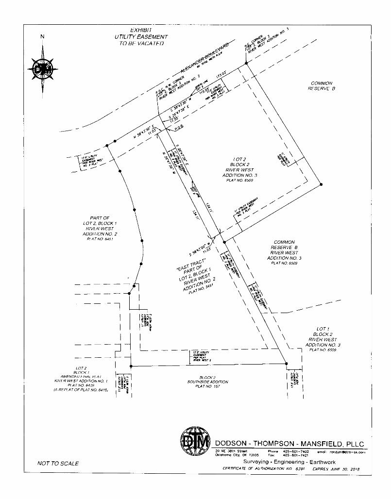
S丁AFF REPORT - Uti看itv Easement Ciosure ReclueSt
TO: PiannIng Comm-SSiOn Membe「s
DATE: Feb…ary 13th, 2017
MATTER: CIoslng a PO巾On Of a U川rty Easement =-foot vvIde, being
app「oximateiy 135, long, Located on Lot 2, BIock l, RiVer West Addit10n
No 2 and 「unning adjacent to the west lo=ine Of Lot 2, BIock 2, RiVe「
West Addit10n No 3 The p「operty lS COmmO両y known as 152 W
Aiexande「 Bivd in SectlOn =, TownshiP 19 North, Range = East
ReclueSt:
The Crty of Sand Sp「ingS WiShes to cIose a portion of a PubilC Utility Easement located
On Lot 2, BIock l, RiVe「WestAdditiOn No 2 to aiiow a comme「Cial buIiding tO be bu冊
across the common lot line
Site Conditions:
The p「operty lS Cu汀ently vacant and zoned CS (Comme「ciai Shopping) The p「operty lS
a part of the RiVe「 West Comme「ciai Deveiopment that is unde「 the 」…SdiCtiOn Of the
Sand Sp「lngS Development Autho自ty and the Keystone Comdo「 Pian
Backqround:
ThlS eaSement WaS dediCated as part ofthe piattlng Of RiVe「West AdditlOn No 2 with a
Standa「d =’pe‖mete「 utlirty easement as cailed fo「 by the Sand Sp「ingS SubdiVISiOn
ReguiatiOnS Howeve「, aS the p「operty has deveioped out the need to combIne POrtlOnS
:;嵩C需言語音盤認諾諾青苗諾b豊b譜L認諾rep「esentatiVeS Of aiI f「anchlSe uti旧es to no描y them of the 「equest to ciose the
easement and to forwa「d ietters of opposltiOn, lf any
Statutorv Reference:
Easements are ciosed by Crty o「dlnanCe m aCCO「dance w冊11 OS 42-110 The
Ciosing Of an easement p「ovIdes fo=tS 「eOPening ln the futu「e shouid a need exist and
not at the City’s expense
「

Staff Recommendation:
The p「oposed easement cIosure wouid not have an adverse affect on the deveiopment
it wouid 「emove a po巾On Of an easement that iS Cu汀entIy p「eventing the iot from being
developed Furthermo「e the newly c「eated iot by SSLC-626 w用stiiI retain a pe「Imete「
easement around lt that Wli a=ow the lots to be served by franchiSe ut冊es
Piannlng CommiSSIOn membe「s are belng aSked to make a 「ec○mmendatlOn tO the Crty
Councli on whethe「 the utilrty easement in this matte「 shouid be ciosed to p「ovlde for a
St…Ctu「aI enc「oachment Shouid the Piannlng CommiSSiOn 「eCOmmend that Crty
Councii approve the 「equest, an O「dinanCe Shaii be drafted and p「esented to the
Council at o「 afte「 ltS Feb…a「y 26川, 2018, reguia「 meeting
Staff 「ecommends app「ovai of ciosing a POrtlOn Of the =’ Utiirty Easement (as
desc「ibed by legal desc‖PtiOn and depiCted by survey exhibit)

UTI」iTY EASEMENT
TO BE VACATED
DESCRIPTION:
Ast「lP Ofland being a PartOfLotTwo (2), ln BIockOne (1), OfRlVERWESTADDITION NO 2,
acco「dIng tO the Reco「ded Plat No 6451, iyIng In the Southwest Quarte「ofSectlOn =,
TownshIP 19 North, Range = East ofthe indlan Me「一dian, Sand Sp「IngS, Tuisa County,
Oklahoma, belng mO「e PartlCuia「iy desc「ibed as fo=ows
COMMENCING at the northeast come「 ofsaid Lot2,
THENCE South 26O47139” East, along the eas川ne ofsaid Lot2, a diStanCe Of 17 55 feet to a
POlnt On the south llne Ofa 17 50 foot Utiiity Easeme=taS eStabl'Shed bythe pIat of RlVERWES丁ADDITION NO 2 and the POiNTOF BEGiNNING,
THENCE contlnuIng South 26O47’39.’East, along said east line, a distance of 134 11 feet,
THENCE South 58O43120”West a d'StanCe Of = O3 feetto a pointthe weste「iy line Ofan = OO
foot U仙ty Easement as estabiished bythe plat of RIVERWES丁ADDITION NO 2,
THENCE North 26O47’39” West, aiong sa)d westeriy line and pa「aiiei wlth the eas川ne of saId
Lot2’a d'StanCe Of 134.11 feetto a point On the south ii=e Ofafo「esaId 17 50 foot Utiiity
Easement,
THENCE North 58O43130” East, aiong saId south lIne, a diStanCe Of = O3 feetto the POiNT OF
BEGINNING
SaId desc「ibed t「act ofiand contalnS an a「ea Of l,475 squa「e feet orO O339 ac「es, mO「e O「 iess
The bea「ing OfSouth 26O47-39” East, aiong the east llne Of Lot2, in BIock l of RlVER WEST
ADDiTiON NO 2 acco「ding tO the piat 「eco「ded as Piat No 6451 was used as the basiS Of
bea「ingS fo「 thlS Survey
P「epared By
Randa=A Mansfleld, PLS 1613
Dodson Thompson Mansfleid. PLLC
20 NE 38th Street- OKC, OK 73105
Janua「Y lO, 2018

%〆擁印加APPL|CAT工ON TO CLOSE A PUBL|C UT工LエTY ∈ASEM∈NT
REASON FOR REQUEST:
PropertY is being combined with a= ofLot 2. BIock 2. River West Addition No. 3 to be
developed and have a structure built across the common lot line. ProDertV WaS aPPrOVed
for a lot-COmbination through the Sand SDrings Plaming Commission.
crtyc。un。11dat。:臆_ Z !笹口め _A。,,。n:
Comments :