AGENDA ITEM 3 - dac.sa.gov.au · diverse townscape of The Parade. The proposal will provide an...
61
TABLE OF CONTENTS AGENDA ITEM 3.1 Officer: Connie Parisi Investment Management – Development Division Department of Planning, Transport & Infrastructure PLANNING REPORT PAGES AGENDA REPORT 2-28 DEVELOPMENT PLAN POLICY PROVISIONS 29-51 ATTACHMENTS ZONE MAP 52 FORMS AND CERTIFICATE OF TITLE 53-62 PLANS AND DRAWINGS 63-80 TECHNICAL REPORTS 81-151 REFERRAL AGENCY COMMENTS 152-157 REPRESENTATIONS 158-180 APPLICANTS RESPONSE 181-194
Transcript of AGENDA ITEM 3 - dac.sa.gov.au · diverse townscape of The Parade. The proposal will provide an...
TABLE OF CONTENTS
AGENDA ITEM 3.1
Officer: Connie Parisi
Investment Management – Development Division
Department of Planning, Transport & Infrastructure
PLANNING REPORT PAGES
AGENDA REPORT 2-28DEVELOPMENT PLAN POLICY PROVISIONS 29-51
ATTACHMENTS
ZONE MAP 52FORMS AND CERTIFICATE OF TITLE 53-62PLANS AND DRAWINGS 63-80
TECHNICAL REPORTS 81-151
REFERRAL AGENCY COMMENTS 152-157
REPRESENTATIONS 158-180
APPLICANTS RESPONSE 181-194

Application No: 155/M053/14
KNET Reference: 2014/22479/01
Applicant: Pruszinski Architects
Proposal: To demolish existing structures and construct a mixed use development with ground level retail and residential apartments above, together with ancillary carparking.
Subject Site: 254-256 The Parade Norwood (Certificates of Titles Volume 5236 Folio 211, Volume 5236 Folio 212, Volume 5236 Folio 213)
Relevant Authority: Development Assessment Commission pursuant to Schedule 10 section – 4C(b) “Development that involves the erection or construction of a building that exceeds 4 storeys in height in that part of the area of the area of the Corporation of the City of Norwood Payneham & St Peters defined in the relevant Development Plan as District Centre (Norwood) Zone”
Zone / Policy Area: District Centre (Norwood) Zone (Parade East Policy Area)
Public Notification: Category 2
Representations: 2
Lodgement Date: 5 December 2014
Development Plan: Norwood Payneham and St Peters (City) Development Plan Consolidated 31 October 2013
Assessment Officer Concetta Parisi
Recommendation: Development Plan Consent subject to conditions
1. EXECUTIVE SUMMARY
The applicant seeks approval for the construction of a mixed use multi-level residential and retail development. More specifically, the proposal encompasses two ground level shops, with a variety of 1 to 3 bedroom residential apartments above.
The proposal is consistent with the desired character of the zone which is seeking strong activation of The Parade, ground level retail with residential apartments above. The proposal has received support from the Government Architect in relation to the design
quality and is considered to sit well within the existing and desired future context. The application is also supported from a heritage perspective by the State Heritage Unit.
Vehicular access is proposed from Portrush Road in proximity to this road’s intersection with The Parade (where significant traffic is experienced). Delays for vehicles exiting the proposed development are therefore envisaged. Whilst the supply of carparking is below that sought by the Development Plan, relevant policies allow for dispensation in proximity to public transport, which this development achieves. The Safety and Services Unit of the Department of Planning, Transport and Infrastructure do not object to the proposed development.
Overall, the proposed development is considered to contribute to the character and
diverse townscape of The Parade. The proposal will provide an attractive pedestrian space and visual appeal. The ground level built form comprising of narrow tenancies has been designed to reflect the existing fine grain of The Parade.
It is recommended that the proposal be granted consent subject to conditions.
AGENDA ITEM 3.1:

2. BACKGROUND
Strategic context
In 2013, the City of Norwood Payneham & St Peters, Kent Town and The Parade Strategic Growth Development Plan Amendment (DPA) was gazetted, which allows for medium density residential living above mixed use development. More specifically, the rezoning included the introduction of policies along parts of The Parade to encourage a new form of urban living that enable more people to enjoy the benefits of an inner city lifestyle. Policies encourage mixed-use forms of development complemented by well-designed and contemporary housing that reflects the way people want to live—close to public transport, jobs and vibrant places. This DPA also included the introduction of the Air and Noise Emissions Overlay that enables applicants to move noise assessment to the building stage of the approvals process. This Overlay also contains planning policies to protect new noise and air quality
sensitive development from noise and air emissions generated from major transport corridors (road and rail) and mixed land use. The designated noise source in this case is The Parade. Pre lodgement process The applicant commenced the DPTI pre-lodgement process in March 2014. A key focus during the process was the desire to discuss design and the proposed access/egress arrangement off Portrush Road. The proposal has completed 3 pre lodgement panel meetings and 2 Design Review sessions. The pre lodgement panel members included representatives from Council’s Administration, the Office of Design and Architecture SA, Renewal SA, Heritage SA, and Transport Services (DPTI). Key changes to the project arising from the pre-lodgement process include:
- Resolution of the expression and proportion of the podium element.
- Refinement of the lobby, entry area for retail shops. - Improvement to pedestrian amenity. - Improvement of apartment amenity, particularly having regard to context and
future development. - Further development of the atrium walkways to ensure privacy and protection
from microclimates. - Improvement to the quality of the fire stairs given the incorporation of a single lift
only. A pre lodgement agreement was not reached in this instance. 3. DESCRIPTION OF PROPOSAL
Application details are contained in the ATTACHMENTS.
A summary of the proposal is as follows (overleaf):

Land Use Description Retail and Residential
Building height 19.4 metres from ground level (to the top of the stair access and roof plant area; 18.4 metres to the top-most part of the roof
Description of levels
Ground floor: 2 independent retail tenancies (200 square metres and 170 square metres); apartment lobby and waste storage areas; 23 carparking spaces (including 2 disabled spaces) and 44 bicycle parking spaces and storage cage. Level 1: 21 carparking spaces and storage cage. Level 2: 9 apartments (6x1 Bedroom, 3x2 Bedroom) Level 3: 9 apartments (2x1 Bedroom, 6x2 Bedroom, 1x3 Bedroom) Level 4: 9 apartments (2x1 Bedroom, 6x2 Bedroom, 1x3 Bedroom)
Level 5: 9 apartments (2x1 Bedroom, 6x2 Bedroom, 1x3 Bedroom) Roof: Lift Over-run, plant area, stair access to roof
Apartment floor area sizes (excluding balconies)
1 bedroom apartments: 51 – 66 square metres 2 bedroom apartments: 78 – 94 square metres 3 bedroom apartments: 122 square metres
Site Access Vehicle: via Portrush Road – left in and left out only Bicycle Access: via Portrush Road Pedestrian/Bicycle Access: via The Parade to both the retail and residential components of the development
Car/Bicycle Parking Retail Use:2 carparking spaces within the sub-ground level carpark, adjacent the lift Residential: 42 carparking spaces Bicycle parking: 44 spaces (40 of which are contained within the carpark
Encroachments Yes - Canopy encroachment
Staging Not applicable
The building will be finished with the following selection of materials, colours and
landscaping:
Internal communal entry garden/plaza space (eastern side) – traditional random ashlar ‘Old Adelaide’ cut blue stone
Front screen and canopy – metal vertical fins in burnt orange and horizontal and end plates in dark grey
Apartment Gap Ends – raw finished (concrete)
Solid sections of balustrades – zinc
External walls of apartments – sandstone tones
Roofing and window frames – grey metal roofing and window frames
Landscaping to entry garden – timber and stone seating, timber fence and decking. Plantings will include Japanese Maple, New Zealand Flax, Evergreen
Giant and Clivia.
Landscaping to walkways – typical planting will include: Zealand Flax, Evergreen Giant and Clivia.
A board of colours and materials for the proposal will be available at the meeting.

The following elements are also of note with the proposal:
The two retail tenancies are separated by a communal entry garden/plaza space
The residential apartments will be accessed via aerial walkways which will be landscaped and incorporate seating spots.
Frosted glass screens are proposed for the Level 2 apartments to provide security for those apartments on this level, because otherwise the balconies will be accessed via the roof of the first floor.
4. SITE AND LOCALITY 4.1 Site Description The subject site consists of 3 allotments; the legal description of the site is described as follows:
Lot No Plan Street Number and Street Name
Suburb Hundred CT Reference
2 F130466 254 The Parade Norwood Adelaide 5236/212
210 FP29041 254 The Parade Norwood Adelaide 5236/213
The subject site is located on the southern side of The Parade between Portrush Road to
the east and Cairns Street to the west. The site has a frontage of some 32 metres to The Parade and a depth of some 45 metres. The frontage to Portrush Road measures some 9.14 metres which is a right of way appurtenant to the subject site. The site measures approximately 1 755 square metres in total. The site currently contains a commercial building that was formerly occupied by a furniture bulky goods outlet, together with a sealed carparking area. The site currently
has access from both The Parade (left in/left out) and Portrush Road (left in/left out). The site is generally flat and contains no trees. 4.2 Locality The locality is characterised by a mix of retail, commercial and residential land uses. Retail shops are located immediately to the west and opposite the site. A State Heritage place (described as ‘two storey shops and upstairs dwelling’) abuts the site to the east; this building is currently occupied by office and retail uses. Residential dwellings are located on the sites to the rear, with a disused water tower located on a site to the south.
Buildings are predominantly single to two storey in form, constructed from a number of eras. The following photographs illustrate the subject site and immediate locality.
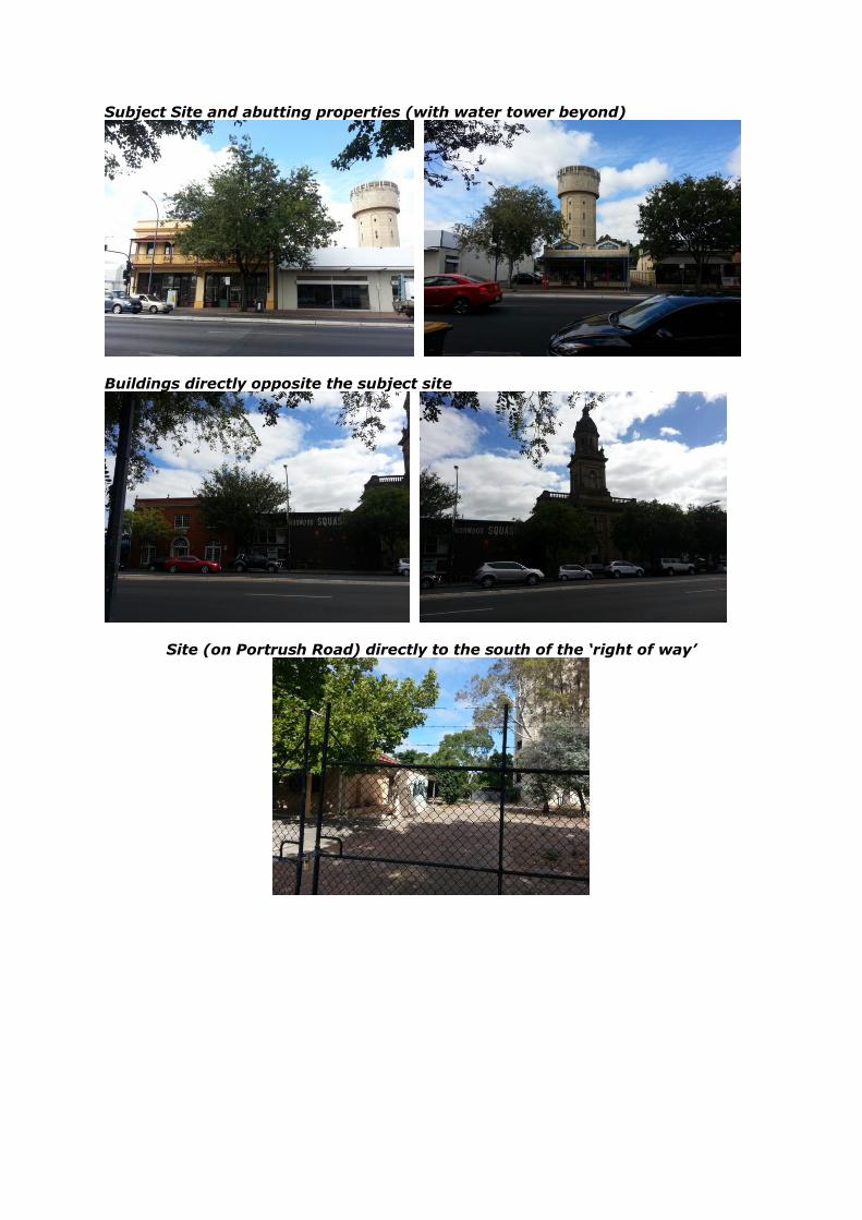
Subject Site and abutting properties (with water tower beyond)
Buildings directly opposite the subject site
Site (on Portrush Road) directly to the south of the ‘right of way’
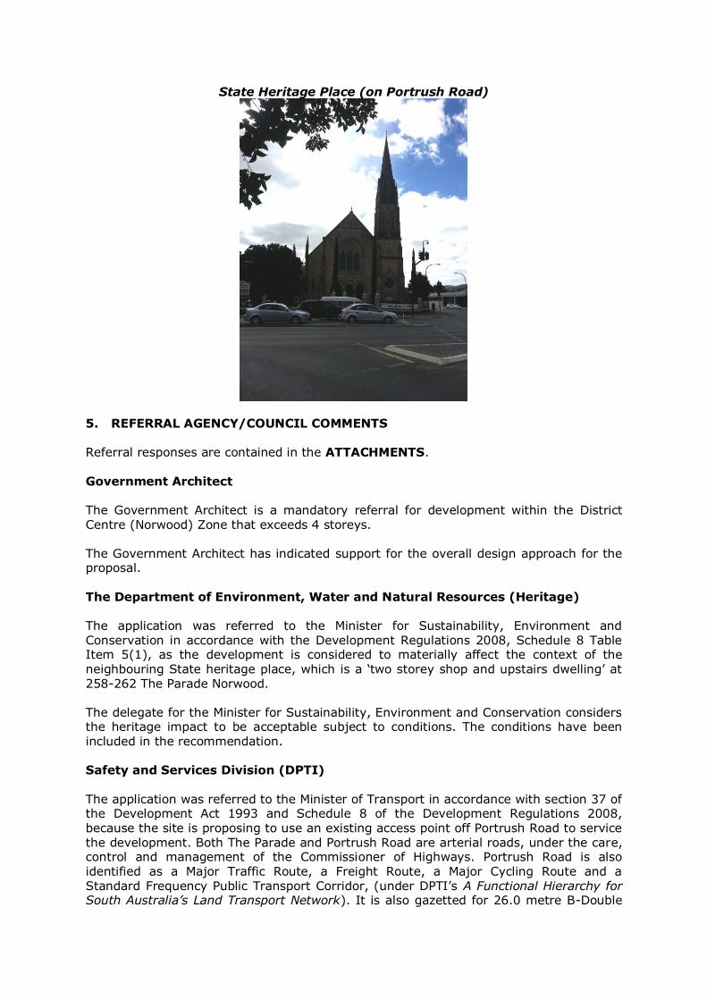
State Heritage Place (on Portrush Road)
5. REFERRAL AGENCY/COUNCIL COMMENTS
Referral responses are contained in the ATTACHMENTS. Government Architect The Government Architect is a mandatory referral for development within the District
Centre (Norwood) Zone that exceeds 4 storeys. The Government Architect has indicated support for the overall design approach for the proposal. The Department of Environment, Water and Natural Resources (Heritage)
The application was referred to the Minister for Sustainability, Environment and Conservation in accordance with the Development Regulations 2008, Schedule 8 Table Item 5(1), as the development is considered to materially affect the context of the neighbouring State heritage place, which is a ‘two storey shop and upstairs dwelling’ at 258-262 The Parade Norwood. The delegate for the Minister for Sustainability, Environment and Conservation considers the heritage impact to be acceptable subject to conditions. The conditions have been included in the recommendation. Safety and Services Division (DPTI) The application was referred to the Minister of Transport in accordance with section 37 of the Development Act 1993 and Schedule 8 of the Development Regulations 2008, because the site is proposing to use an existing access point off Portrush Road to service the development. Both The Parade and Portrush Road are arterial roads, under the care, control and management of the Commissioner of Highways. Portrush Road is also identified as a Major Traffic Route, a Freight Route, a Major Cycling Route and a Standard Frequency Public Transport Corridor, (under DPTI’s A Functional Hierarchy for South Australia’s Land Transport Network). It is also gazetted for 26.0 metre B-Double

vehicles. The Parade is identified as a Major Cycling Route, a Priority Pedestrian Area and a Priority Public Transport Corridor. A summary of the comments received by the Safety and Services Division of DPTI is
provided below:
Having all vehicular access via Portrush Road will result in potential delays for vehicles exiting the site, particularly during the PM peak period. Delays for exiting vehicles during these periods may result in exiting drivers becoming frustrated.
Given the importance of Portrush Road, DPTI will not permit modifications to this road to reduce delays for exiting vehicles.
It will be necessary to limit the size of vehicles able to access the site to a maximum length of 7 metres. This will ensure that all vehicles will be able to enter and exit the site in a forward direction and that simultaneous movement of a service vehicle and a passenger vehicle can occur.
The Metropolitan Adelaide Road Widening Plan (MARWP) shows a possible requirement for a strip of land up to 4.5 metres in width from the Portrush Road
and The Parade frontages of this site for the possible future upgrading of the Portrush Road/The Parade intersection. Although there are no current proposals that would require the acquisition of any land from this property, the consent of the Commissioner of Highways under the Metropolitan Adelaide Road Widening Plan Act is required for all new building works located on or within 6.0 metres of the possible requirement. Commissioner of Highways consent for such building works can be anticipated, however, because the draft Integrated Transport and Land Use Plan (ITLUP) does not include the upgrading of the Portrush Road/The Parade intersection and, therefore, the current road widening requirement will be removed from the MARWP once the ITLUP is finalised.
The Division has recommended a number of conditions to be attached to the approval, if granted, including an advisory note that indicates that DPTI will not permit any changes to the adjacent road infrastructure to accommodate access and egress delays from the development. The conditions and advisory notes have been recommended to be included. 6. PUBLIC NOTIFICATION AND REPRESENTATIONS
The development is deemed a Category 2 development by virtue of Schedule 9, Part 1, 6 (1)(h). A total of two (2) representations were received during the public notification period. A copy of the representations are contained in the ATTACHMENTS. The table below contains a list of the representors:
Name Affected Property Wish to be heard
Mr Roger Richards 252 The Parade Norwood Yes
Manresa Society Inc (MSI), a body associated with St Ignatius College
Allotment 50, Portrush Road, Norwood in Deposited Plan 44631, contained in Certificate of Title Volume 6130, Folio 856
Yes
A summary of the concerns raised by the representor(s) and the applicant’s response is summarised in the table overleaf:

Concern Raised Applicant’s Response
Impact on the structure of
the existing building
As part of the construction process, a dilapidation report
will be prepared to protect the structural integrity of abutting buildings.
Excessive height The proposal achieves the maximum height envisaged for the District Centre Zone. The design also achieves an appropriate human scale by
providing a distinct podium element which incorporates retail tenancies and the level 2 apartments representing a street wall height of approximately 8 metres (which is within the height limit envisaged along The Parade).
Loss of sunlight (impact on solar panels)
The impact on the solar panels would not be much more than what is caused by a two storey development. The overshadowing diagrams demonstrate that both solar panels will receive full sunlight between 11am and 2pm on 21 June and therefore achieving Council Wide PDC 74.
Interruption to business trading during construction (eg noise)
A Construction Environment Management Plan will be prepared. In addition, the applicant has a general duty under section 25 of the Environment Protection Act,
1993, to ensure that no environmental harm is caused to neighbouring properties.
Will interfere with foot traffic, parking
Pedestrian access to the west and east will still be maintained along the frontage of the site during construction. Customer car parking to the rear of the representor’s business will still be maintained.
Impacts on Free and Unrestricted Right of Way
The Right of Way will not contain any temporary or permanent structures/materials during the construction process or post construction. The applicant accepts an appropriate condition to formalise such an arrangement.
Non compliance to Development Plan carparking requirements
The proposal falls short of 20 carpark spaces; recognising that the site satisfies the criteria for discounted car parking, the shortfall is not considered significant.
Concerns with parking layout and access
GTA Consultants has confirmed that the carparking layout and access arrangements will be in accord with the Australian Standards.
Waste management access arrangements
GTA Consultants has demonstrated that a smaller waste truck can service the development, access the car park area and leave the site in a forward direction.
Traffic impact generated from the development
GTA Consultants have confirmed that the traffic impact will not be unreasonable on the surrounding road network.
Concerns in relation to the status of the report prepared by GTA Consultants
GTA Consultants have updated the report to respond to the concerns.
Lack of details around loading and unloading for retail tenancies
GTA Consultants have confirmed that due to the size and nature of the retail shops, any loading/unloading could only occur on The Parade; therefore, the right of way will not need to be used for such activity.

Potential use of balconies for storage
Each apartment will be provided with both internal storage cages and storage cages in each of the car park levels. The Scheme Description will also be able to control the use of the balconies when a community title is created.
Potential noise from mechanical services
A condition of consent can be included to ensure that the noise levels associated with the mechanical services are in accord with the relevant Environment Protection (Noise) Policy criteria.
Overshadowing The overshadowing diagrams demonstrate that the proposal achieves the relevant provisions in the Development Plan.
Overlooking onto adjacent residential development
Due to the orientation of the balconies (east or west outlook), the distance between the proposed development and the water tower, and the fact that the
water tower has very small windows and no balconies, the potential for overlooking would be minimal.
Electricity supply and SAPN Transformer may impact on design
Discussions with SAPN will be held during the detailed design stage.
Construction process The applicant will undertake a Construction Environment
Management Plan which will deal with traffic and access related matters amongst other issues.
The concern relating to the Right of Way is a civil matter which requires to be resolved between the relevant parties. Discussion on all other matters, will be addressed below.
7. PLANNING ASSESSMENT 7.1 Policy Overview The subject site is situated within the District Centre (Norwood) Zone and more specifically, the Parade East Policy Area, as prescribed within the Norwood Payneham and St Peters (City) Development Plan. (Refer to Figure 2 overleaf). The District Centre (Norwood) Zone seeks to accommodate integrated, mixed use, medium rise buildings with ground floor uses that create active and vibrant streets with commercial and/or residential development above.
Development will respect the heritage and streetscape significance of historic buildings on The Parade particularly the State Heritage listed former church and church buildings located on the northern corners of the intersection of Portrush Road and The Parade. New buildings will be sited and designed to reinforce the high street character of The Parade. The character of The Parade will be reinforced by a well-defined low to medium scale built form edge abutting the footpath and continuing the established width, rhythm and pattern of facades that generally support a variety of tenancies with narrow frontages. To maintain a human scale at street level, the upper levels of buildings will be recessed behind the dominant two storey (or 8 metre) podium/street wall heights. The maximum building height is 5 storeys and 18.5 metres.

Figure 1 – Zoning of subject site and locality
Pedestrian movement will continue to be concentrated along The Parade frontages with the pedestrian environment enhanced with verandahs, pergolas and awnings extending over the footpath, achieving a sense of human scale and a visually interesting environment. Development which incorporates more than 20 dwellings will provide a range of dwellings sizes and a proportion of affordable housing.
Development should achieve consolidated car parking areas at the rear of properties facing The Parade with the preferred access being from Queen Street and rear laneways. Council Wide The Council Wide provisions for provide guidance as to appropriate housing choice,
private open space, minimum unit sizes and the extent of natural light, ventilation, outlook and effective design outcomes. Relevant planning policies are contained in the concluding appendices.

Overlay Section The site is subject to the following Overlays:
Affordable Housing The proposal is subject to the affordable housing overlay. The proposal does not purport to provide affordable housing in accordance with the overlay. Although this is the case, the proposal does seek to accommodate 1 bedroom apartments which will be close to the affordable ‘price point’. Noise and Air Emissions This site is located within the designated area for the Noise and Air Emissions Overlay, and as such requires assessment against Minister’s Specification SA 78B for Construction Requirements for the Control of External Sound.
7.2 Planning Assessment The application has been assessed against the relevant provisions of the Norwood Payneham and St Peters (City) Development Plan, which are contained in ATTACHMENT A. The primary areas warranting scrutiny and discussion include:
Land Use and Character Design and Appearance Building Height and Setbacks Residential Amenity Pedestrian Amenity Heritage Impact Traffic, Parking and Access Overshadowing and Overlooking Environmental Issues (sustainability, crime prevention, acoustic, wind, waste
management and site contamination) Affordable housing
Land Use and Character The Desired Character for the District Centre Zone and more specifically, the Parade East Policy Area, envisage small scale retailing at ground level with residential land uses above to maintain active ground floor uses and reinforce The Parade as an Activity Centre of eastern metropolitan significance.
The form of the land use is outlined via Principles of Development Control 5 and 6 of the District Centre Zone which state: “5 Where a development comprises more than two (2) storeys above natural ground level, the levels above the ground and first floor levels should comprise residential accommodation (which may include serviced apartments).
6 Where residential accommodation above ground floor level non residential uses is proposed, the average floor area of the residential component should not exceed 100 square metres per dwelling.”

The proposal is in keeping with the envisaged land uses for the zone and provides a range of apartment sizes to accommodate a variety of occupants. The retail component accommodates the ground and first floor tenancies with frontages to The Parade.
Although the average floor area for the 3 bedroom apartments exceed 100 square metres, the variance is negligible considering that there are only three, 3 bedroom apartments (a total of 8% of the total number of apartments), and these apartments are provided with generous private open space in the form of balconies. Overall, the proposed land use is considered to be meeting the intent of the envisaged land uses for the zone. Design and Appearance Both the Council Wide and the Zone provide a policy framework which imparts guidance about the form of development envisaged for the District Centre (Norwood) Zone. Council wide policies suggest architectural excellence, articulation, colour and detailing
with the incorporation of vertical and horizontal components. Council Wide Principle of Development Control 287 (c) specifically indicates that buildings should ensure walls on the boundary that are visible from public land include visually interesting treatments to break up large blank facades. Specifically to the Zone, the desired character envisages that the “character of The Parade will be reinforced by a well defined low to medium scale built form edge abutting the footpath and continuing the established width, rhythm and pattern of facades that generally support a variety of tenancies with narrow frontages”. The Desired Character statement for the zone also states: “The front and side elevations of buildings (or portions of buildings) fronting The Parade and extending into adjacent side streets, will incorporate materials and finishes of a high quality and complement (without replicating) the materials and finishes used in the historic building fabric and will avoid visible expanses of tilt-up concrete walling. Shopfronts will incorporate visible entry foyers and display windows and will not be secured through the use of roller shutters.” The proposed building design will incorporate ground floor retail spaces which are
separated by a wide laneway access path, with seating areas and plantings. The laneway also leads to the residential apartment building lobby. The width of the laneway continues up into the fabric of the building and separates the residential apartments into two separated building forms. Elevated walkway links provide access to each of the residential apartments. The building design maintains the established rhythm of narrow building frontages.
The facade of the building will be constructed on the front property boundary of The Parade and be predominantly glazed to allow visibility and create pedestrian interest. The built form on the boundary will be of low scale, (2 storeys with a total height of some 8.2 metres), maintaining the reference to existing buildings along The Parade and achieving human scale at street level. The entries to the retail areas and the apartments are orientated to The Parade and are clearly identifiable. Canopies (although moderate in
depth) extend over the footpath, providing some degree of pedestrian comfort. ‘Traditional random ashlar ‘old Adelaide’ cut blue stone’ will be used along one side wall of the laneway entrance, to reflect the existing historic building fabric of buildings along The Parade. The Government Architect has requested additional detail on the podium materiality; this has been requested to be addressed via a reserved matter.
The side and rear elevations are well articulated due to the varied side setbacks; this is complemented by the use of a variety of building materials and the incorporation of external balconies. The balconies are also integrated with the overall architectural form of the building, breaking up the rectilinear form of the building.
Structures located on the roofs of buildings to house plant and equipment, will be mostly screened from view (from ground level) by concrete panels, finished in colours to match the principal colour of the building walls. The transformer will be located at the rear of the building so that the facade will not be interrupted by services. Council’s administration indicated that the ground floor of the building be at the same level of the adjacent footpath, to enable all access points to match the existing footpath level. This requirement will be addressed via a condition. Overall, the built form will be visually appealing from all angles due to the use of varied materials, integrated balconies, articulation, and attention to massing via the use of the walkways to create two separate built forms. Council’s administration is also supportive
of the general design aesthetic and the focus on high quality pedestrian space. Building Height and Setbacks The primary policies relating to the height and setback of development within the District Centre Zone and more specifically, The Parade East Policy Area include: “Principle of Development Control 3: Development should maintain a pedestrian scale at street level and should include a clearly defined podium or street wall fronting The Parade (and extending into side streets) with a maximum building height of 2 storeys or 8 metres.” “Principle of Development Control 8: The height of buildings and structures should be consistent with the heights specified in the relevant policy area and as indicated on Concept Plan Fig DCe/1.” (2-5 storeys/18.5 metres) “Principle of Development Control 10: Development located above the maximum allowable podium/street wall height should be setback from the street wall boundary in order to:
(a) Reinforce a lower scale (2 or 3 storey) building from along the primary and secondary street frontages;
(b) Minimise overshadowing of the public realm; and (c) Maintain the prominence and integrity of heritage buildings; And in order to achieve these aims, the set back should generally be in the order of 6 metres from the street wall boundary.
“Principle of Development Control 11: The front set-back of new buildings at ground level should maintain the traditional pattern of development abutting street boundaries to define the street space.” The proposed building will have a maximum building height of 18.5 metres to the main parapet of the building and some 19.4 metres to the top of the roof top structures
(including the lift over-run). As the proposal will involve a sub-ground carpark, the proposal will have the appearance of a 6 storey building from the rear laneway. However, from The Parade, the proposal will consist of a 5 storey elevation. In any event, the main part of the building will not exceed the overall height limit envisaged by the zone.

The ground and first floor extend for a height of some 8 metres, with the remainder of the building then setback 6 metres from The Parade (excluding the deck) to create a clearly defined podium onto The Parade.
In relation to side setbacks, 291 indicates that “residential buildings (or the residential floors of mixed use buildings) should: (a) have adequate separation between habitable room windows and balconies from other buildings to provide visual and acoustic privacy for dwelling occupants and allow the infiltration of daylight into interior and outdoor spaces; and (b) ensure living rooms have, at a minimum, a satisfactory short range visual outlook to public or communal space”. As the proposal will consist of balcony areas on the boundary, glass screens are proposed to provide privacy to the residential occupants. The glass screens will be at full height (from floor to ceiling level). The glass screens will allow infiltration of daylight to the internal spaces. (Refer to the diagram below which illustrates the appearance of the balconies when looking towards the south west corner of the building).
Each apartment will have a visual outlook towards the City, The Parade or the Adelaide
Hills beyond. The rear windows will be abutting the rear ‘right of way’ laneway and therefore the amenity of the rooms on the boundary will be protected. Overall, the proposal is considered to be of a height which is consistent with the
envisaged desired character and includes setbacks that maintain the pattern of development of The Parade and maintain an appropriate degree of residential amenity. Residential Amenity The Development Plan outlines a number of requirements in respect to residential amenity including access to natural light and ventilation, provision of useable private open space and provision of storage areas. The building has been designed so that the living areas and private open space of the majority of the apartments are north facing. All rooms within each apartment have access to natural light and natural cross-ventilation. The east and west facing windows will have sun-shading devices.
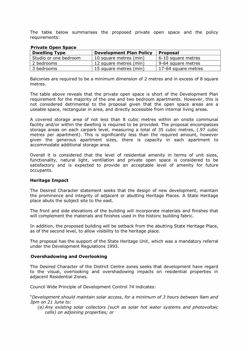
The table below summarises the proposed private open space and the policy requirements: Private Open Space
Dwelling Type Development Plan Policy Proposal
Studio or one bedroom 10 square metres (min) 6-10 square metres
2 bedrooms 12 square metres (min) 9-64 square metres
3 bedrooms 15 square metres (min) 17-64 square metres
Balconies are required to be a minimum dimension of 2 metres and in excess of 8 square
metres. The table above reveals that the private open space is short of the Development Plan requirement for the majority of the one and two bedroom apartments. However, this is not considered detrimental to the proposal given that the open space areas are a useable space, rectangular in area, and directly accessible from internal living areas. A covered storage area of not less than 8 cubic metres within an onsite communal facility and/or within the dwelling is required to be provided. The proposal encompasses storage areas on each carpark level, measuring a total of 35 cubic metres, (.97 cubic metres per apartment). This is significantly less than the required amount, however given the generous apartment sizes, there is capacity in each apartment to accommodate additional storage area.
Overall it is considered that the level of residential amenity in terms of unit sizes, functionality, natural light, ventilation and private open space is considered to be satisfactory and is expected to provide an acceptable level of amenity for future occupants. Heritage Impact
The Desired Character statement seeks that the design of new development, maintain the prominence and integrity of adjacent or abutting Heritage Places. A State Heritage place abuts the subject site to the east. The front and side elevations of the building will incorporate materials and finishes that will complement the materials and finishes used in the historic building fabric.
In addition, the proposed building will be setback from the abutting State Heritage Place, as of the second level, to allow visibility to the heritage place. The proposal has the support of the State Heritage Unit, which was a mandatory referral under the Development Regulations 1993.
Overshadowing and Overlooking The Desired Character of the District Centre zones seeks that development have regard to the visual, overlooking and overshadowing impacts on residential properties in adjacent Residential Zones. Council Wide Principle of Development Control 74 indicates: “Development should maintain solar access, for a minimum of 3 hours between 9am and 3pm on 21 June to:
(a) Any existing solar collectors (such as solar hot water systems and photovoltaic cells) on adjoining properties; or

(b) An area of at least 10m2 on the north facing roof of the existing building(s), in the event that there are no existing solar panels and/or photovoltaic cells on the adjoining property.”
The shadowing of the solar collectors on the roof of the building of 252 The Parade, was raised as a concern by one of the representors. The shadowing diagrams provided reveal that on the 21 June, between the hours of 9am and 3pm, the residential properties to the south-west, south and south-east, with existing or potential solar collectors, will receive a minimum of 3 hours solar access. In addition, those residential properties will also receive a minimum of 3 hours solar access to their private open space. Overlooking was also a concern raised by a representor. Due to the presence of balconies and living room windows, there will be a degree of overlooking onto the private open space of residential properties. However, given the distance of the proposed development, and the presence of existing trees, the overlooking is relatively restricted. A right of way between the rear apartments and the existing dwelling to the south, also assists with restricting the level of overlooking due to the distance.
Overall, in light of the desired height for the site, the likely level of overshadowing and overlooking is not considered unreasonable. Traffic, Parking and Access The Council Wide and Zone policies in the Development Plan delineate a number of policies that seek to achieve adequate, safe and convenient access and off-street parking, sufficient bicycle parking which are well located, accessible and well lit, and well designed access arrangements for service vehicles and loading/unloading of goods. Discussion on traffic, parking and access issues will be discussed in detail below. A number of concerns relating to this topic were also raised via the representations and the Safety and Services Division of DPTI. Traffic and Access Currently, the site has one crossover to Portrush Road and one crossover to The Parade. Both access points currently provide ingress and egress vehicular movements and are limited to left-in/left-out manoeuvres. The cross over to Portrush Road is connected to a
right of way driveway providing access to the subject site and neighbouring properties. The site was formerly occupied by a bulky goods outlet; according to GTA Consultants, such a land use is expected to generate 26 trips during peak hour, with approximately 13 trips at each access point, (based on the floor area of 950 square metres). It is expected that the proposed mixed use development (retail and residential apartments) will generate 13 trips during the peak hour, which was what was expected during peak
hour for the bulky goods outlet. Accordingly, the number of trips during peak hour would not be any more than previously experienced. When considering the size of the apartments - the majority of which are 1-2 bedrooms (91% of the total apartments) - and the location of the development on The Parade which is in close proximity to public transport facilities, the traffic generated from the
development is considered acceptable and not significantly more than what was previously generated. GTA Consultants assessed the delay expected for vehicles exiting the site during peak periods using SIDRA Intersection Software. This revealed that during peak hour AM and PM periods, there are sufficient gaps in the free flow of traffic along Portrush Road to
enable vehicles to exit the site. There is an average delay of 36 seconds during AM peak periods and 55 seconds during PM peak periods for left turn movements out of the site. GTA Consultants also confirmed that vehicles travelling from the north on Portrush Road
would likely undertake a U-turn at William Street and Cypress Street to the south of the site on Portrush Road. These locations have a clear sight distance to enable drivers to undertake a U-turn. There is no doubt that there will be some delay with exiting onto Portrush Road during peak hour periods; however, this is not dissimilar to similar types of development, for example, in the city where the courtesy of drivers is relied upon. It is expected that occupants will rely on such courtesy and will adapt to anticipate the delays during peak hours. In relation to unloading and loading for the retail tenancies, given the size of the tenancies, loading will be infrequent and likely small in nature. Existing on-street loading zones or parking spaces along The Parade will be available outside of peak hours for
such deliveries. In summary, the access/egress point from Portrush Road is supported due to the following reasons:
- The Parade retail precinct envisages an increase to pedestrian movement. Removing access/egress to The Parade will minimise pedestrian and vehicle conflict.
- Heavy vehicles entering the site from The Parade (for garbage collection, etc) would not be favourable from The Parade; access/egress for such movements would be more favourable off Portrush Road.
- The anticipated number of vehicle trips during peak hour will not be significantly more than what was previously anticipated for the bulky goods outlet.
- Based on the worst case scenario, there will be a delay of some 35.8 seconds (AM Peak Period) and 54.6 seconds (PM Peak Period), with an average queue length of 1.9 metres and 1.6 metres respectively. The extent of vehicles ‘queuing’ within the development is not considered to be significant.
The Safety and Services Division of DPTI have not opposed access and egress being achieved via Portrush Road. Council’s administration have also indicated that the
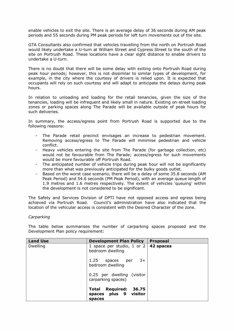
location of the vehicular access is consistent with the Desired Character of the zone. Carparking The table below summarises the number of carparking spaces proposed and the Development Plan policy requirement:
Land Use Development Plan Policy Proposal
Dwelling 1 space per studio, 1 or 2 bedroom dwelling 1.25 spaces per 3+ bedroom dwelling
0.25 per dwelling (visitor carparking spaces) Total Required: 36.75 spaces plus 9 visitor spaces
42 spaces
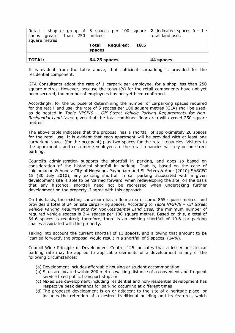
Retail – shop or group of shops greater than 250 square metres
5 spaces per 100 square metres Total Required: 18.5
spaces
2 dedicated spaces for the retail land uses
TOTAL:
64.25 spaces
44 spaces
It is evident from the table above, that sufficient carparking is provided for the residential component.
GTA Consultants adopt the rate of 1 carpark per employee, for a shop less than 250 square metres. However, because the tenant(s) for the retail components have not yet been secured, the number of employees has not yet been confirmed. Accordingly, for the purpose of determining the number of carparking spaces required for the retail land use, the rate of 5 spaces per 100 square metres (GLA) shall be used,
as delineated in Table NPSP/9 – Off Street Vehicle Parking Requirements for Non-Residential Land Uses, given that the total combined floor area will exceed 250 square metres. The above table indicates that the proposal has a shortfall of approximately 20 spaces for the retail use. It is evident that each apartment will be provided with at least one
carparking space (for the occupant) plus two spaces for the retail tenancies. Visitors to the apartments, and customers/employees to the retail tenancies will rely on on-street parking. Council’s administration supports the shortfall in parking, and does so based on consideration of the historical shortfall in parking. That is, based on the case of Lakshmanan & Anor v City of Norwood, Payneham and St Peters & Anor (2010) SASCFC 15 (30 July 2010), any existing shortfall in car parking associated with a given development site is able to be ‘carried forward’ when redeveloping the site, on the basis that any historical shortfall need not be redressed when undertaking further development on the property. I agree with this approach. On this basis, the existing showroom has a floor area of some 865 square metres, and provides a total of 24 on site carparking spaces. According to Table NPSP/9 – Off Street
Vehicle Parking Requirements for Non-Residential Land Uses, the minimum number of required vehicle spaces is 2-4 spaces per 100 square metres. Based on this, a total of 34.6 spaces is required; therefore, there is an existing shortfall of 10.6 car parking spaces associated with the property. Taking into account the current shortfall of 11 spaces, and allowing that amount to be
‘carried forward’, the proposal would result in a shortfall of 9 spaces, (14%). Council Wide Principle of Development Control 125 indicates that a lesser on-site car parking rate may be applied to applicable elements of a development in any of the following circumstances:
(a) Development includes affordable housing or student accommodation (b) Sites are located within 200 metres walking distance of a convenient and frequent
service fixed public transport stop; or (c) Mixed use development including residential and non-residential development has
respective peak demands for parking occurring at different times (d) The proposed development is on or adjacent to the site of a heritage place, or
includes the retention of a desired traditional building and its features, which
hinders the provision of on site parking or the most effective use of the spaces within the site;
(e) The parking shortfall is met by contribution to a Car Parking Fund (where one is available); or
(f) The development qualifies for certification under the Green Energy rating program, or similar program.
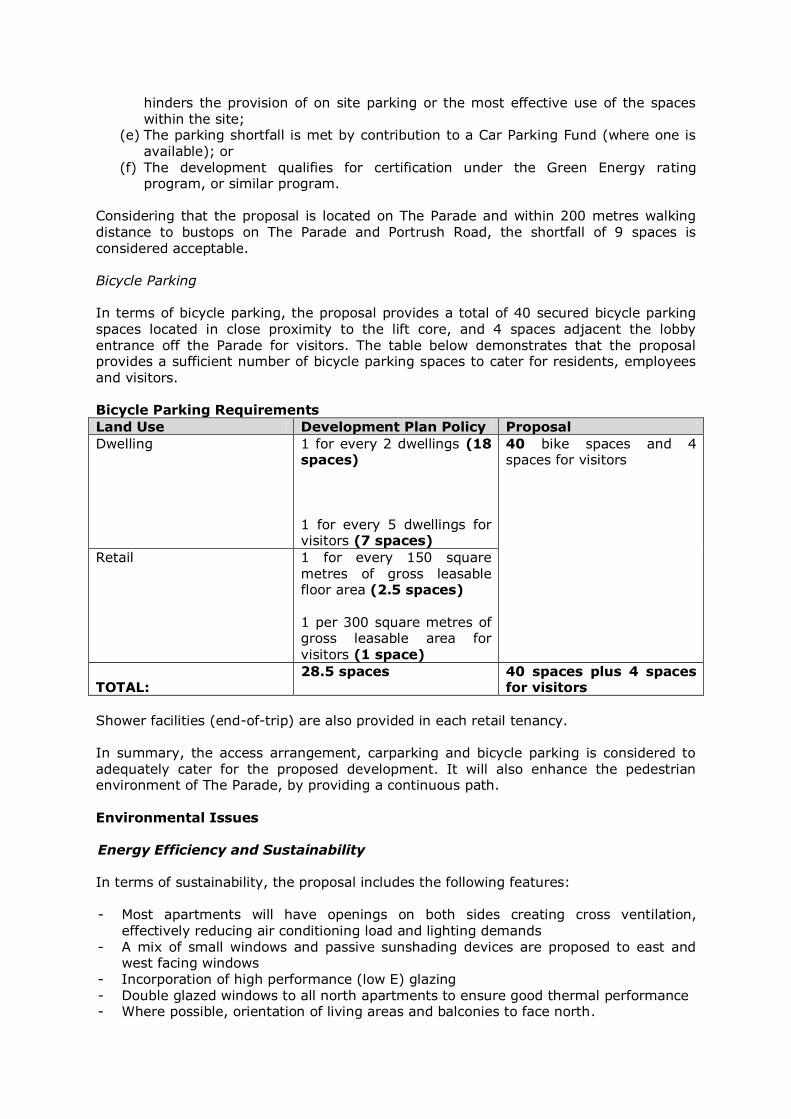
Considering that the proposal is located on The Parade and within 200 metres walking distance to bustops on The Parade and Portrush Road, the shortfall of 9 spaces is considered acceptable. Bicycle Parking In terms of bicycle parking, the proposal provides a total of 40 secured bicycle parking spaces located in close proximity to the lift core, and 4 spaces adjacent the lobby entrance off the Parade for visitors. The table below demonstrates that the proposal provides a sufficient number of bicycle parking spaces to cater for residents, employees
and visitors. Bicycle Parking Requirements
Land Use Development Plan Policy Proposal
Dwelling 1 for every 2 dwellings (18 spaces) 1 for every 5 dwellings for visitors (7 spaces)
40 bike spaces and 4 spaces for visitors
Retail 1 for every 150 square metres of gross leasable floor area (2.5 spaces) 1 per 300 square metres of gross leasable area for visitors (1 space)
TOTAL:
28.5 spaces 40 spaces plus 4 spaces for visitors
Shower facilities (end-of-trip) are also provided in each retail tenancy. In summary, the access arrangement, carparking and bicycle parking is considered to adequately cater for the proposed development. It will also enhance the pedestrian environment of The Parade, by providing a continuous path.
Environmental Issues Energy Efficiency and Sustainability In terms of sustainability, the proposal includes the following features: - Most apartments will have openings on both sides creating cross ventilation,
effectively reducing air conditioning load and lighting demands - A mix of small windows and passive sunshading devices are proposed to east and
west facing windows - Incorporation of high performance (low E) glazing - Double glazed windows to all north apartments to ensure good thermal performance - Where possible, orientation of living areas and balconies to face north.
The proposal is considered to substantially satisfy the principles relating to sustainable design.
Crime Prevention The Council wide provisions in the Development Plan for Norwood Payneham St Peters (City) seek that development be designed to address maximise surveillance of public spaces, (through incorporation of clear sight lines, appropriate lighting and permeable barriers), maximise casual surveillance, discourage access between roofs, balconies and windows of adjoining dwellings, avoid pedestrian entrapment spots and routes. The proposal is seeking to adopt the following crime prevention measures:
Clear sight lines within the carpark, particularly around the stairwell, storage cage and lift areas
Motion sensor lighting throughout the carpark and stairwell
Security lighting over rear pedestrian and vehicular access point Casual surveillance from those balconies facing The Parade and the rear laneway Screens associated with apartments on level 2, which will stop intruders from
being able to access the apartments via the roof (associated with Level 1). It is noted that no details around lighting have been provided to the communal entry/plaza space; in addition, motion sensor lighting is recommended for the bicycle storage spaces also. It is recommended that these be addressed via a condition. Noise and Wind Analysis The site is subject to the Noise and Air Emissions (Overlay 7) and is located on the Parade which is identified as a Designated Road: Type B road. Essentially the policy indicates that development should place rooms more sensitive to air quality and noise impacts further away from the emission source. The applicant engaged Aurecon to conduct a noise monitoring and modelling exercise. Firstly, the analysis revealed that environmental noise emission from the project site will primarily consist of noise from new building services associated with the development.
These include the operation of plant mounted on the roof, carpark ventilation fans, general ventilation systems, as well as fixed domestic machines. At this stage, the detail around the specific selection of building services plant equipment for the development have not been made. Accordingly, a condition will be recommended to address this component. Secondly, the transformer should be mounted on neoprene mounts or waffle pads to
minimise structure-borne noise transfer through the development. Finally, a number of minimum acoustic performance requirements have been recommended to ensure that the development is protected from external noise intrusion. The analysis also included consideration of noise from balconies and noise from people in the public walkways impacting on centrally located bedrooms. The requirements relate to
external walls, ground floor slab thickness, external glazing performance, roof and ceiling construction for top floor apartments, non glazed external doors, ventilations systems and aircraft noise intrusion. Most of the recommendations have been detailed on the plans.

Overall, the acoustic performance requirements will ensure that occupants and surrounding residents are protected from noise from within, and external to, the development.
In terms of the wind analysis, due to the low rise nature of the proposed development, upper level setbacks from The Parade and shielding provided by surrounding buildings, it is not anticipated that the building will influence the wind patterns of the surrounding micro-climate. Waste Management General waste and co-mingled recycling are proposed to be transported down onto the ground floor waste room of each building via separate bin chutes located on each residential floor, and manually for ground floor retail tenancies. Green organics and hard electronic waste will be moved manually into their respective ground floor storage areas by occupiers/users.
The tenancy strata corporation will remove general waste and co-mingled recycling from the building once a week. Green organic waste and hard electronic waste will be collected every two weeks. A waste removal company will be contracted to manage the waste and empty bins from the ground floor. Concern by a representor was raised with respect to the service access issue. GTA Consultant advised that a refuse vehicle similar to an Isuzu NPR 400 Garbage Compactor vehicle will be used for refuse collection. This vehicle will be of a suitable height for the vertical clearance required in the ground level car park, and has a length of 6-8 metres. The analysis by GTA Consultants revealed that such a vehicle will be able to enter and exit the site in a forward motion. Affordable Housing The proponent has indicated that the proposal will not be entering into an agreement for Affordable Housing; however, due to the variety of dwelling types offered, ranging from
1 to 3 bedrooms, a number of apartments are expected to be marketed at the price point for affordable housing. Site contamination The planning consultant on behalf of the applicant has indicated that the site has been historically used for a range of retail uses and carparking, suggesting that there has not
been any activities undertaken that may have contaminated the site. However, the applicant has agreed to a condition which requires a definitive statement from a suitably qualified environmental auditor advising that the site is suitable for its intended purpose. A condition requesting a Construction Environment Management Plan (CEMP) will also be requested to ensure that environmental harm and disturbance during
construction is minimised. This will address the concern raised by the representors. 8. CONCLUSION When assessing the proposal against the relevant provisions of the Development Plan, it is considered that the proposed development satisfies the majority of the relevant

provisions of the Development Plan and subsequently warrants Provisional Development Plan Consent subject to the following conditions. 9. RECOMMENDATION
1) RESOLVE that the proposed development is NOT seriously at variance with the
policies in the Development Plan. 2) RESOLVE to grant Development Plan Consent to the proposal, by subject to the
following conditions of consent. Planning Conditions:
Planning Conditions:
1. Except where minor amendments may be required by other relevant
Acts, or by conditions imposed by this application, the development shall be established in strict accordance with the details and plans, as submitted in Development Application 155/M053/14 including:
Drawings by Pruszinski Architects:
Reference Date
01 11.06.2014
02 04.09.2014
03 08.04.2014
04 02.12.2014
05 02.12.2014
06 02.12.2014
07 02.12.2014
08 02.12.2014
09 02.12.2014
10 27.10.2014
11 27.10.2014
12 02.12.2014
13 02.12.2014
14 02.12.2014
15 02.12.2014
16 02.12.2014
17 02.12.2014
Reports / Correspondence:
Planning Statement prepared by Connor Holmes Fyfe dated October 2014
Acoustic and Wind Engineering Report prepared by Aurecon dated 18 September 2014
Waste Management Statement prepared by Pruszinski Architects
Report prepared by GTA Consultants dated 30 October 2014 except where superseded by letter from GTA Consultants dated 12 February 2015

Letter from Pruszinski Architects dated 12th February 2015 – Response to Representations
2. The acoustic attenuation measures recommended in the report prepared
by Aurecon dated 18 September 2014, shall be fully incorporated into the building rules documentation to the satisfaction of the Development Assessment Commission. Such acoustic measures shall be made operational prior to the occupation or use of the development.
3. Mechanical plant or equipment shall be designed, sited and screened to
minimise noise impact on adjacent premises or properties. The noise level associated with the combined operation of plant and equipment such as air conditioning, ventilation and refrigeration systems when assessed at the nearest existing or envisaged noise sensitive location in or adjacent to the site shall not exceed:
a. 50 dB(A) during daytime (7.00am to 10.00pm) and 40 dB(A) during
night time (10.00pm to 7.00am) at the most affected residence when measured and adjusted in accordance with the relevant environmental noise legislation except where it can be demonstrated that a high background noise exists.
4. A Construction Environment Management Plan (CEMP) shall be prepared
and implemented in accordance with current industry standards –
including the EPA publication “Environmental Management of On-site Remediation” - to minimise environmental harm and disturbance during construction.
The management plan must incorporate, without being limited to, the following matters:
a. air quality, including odour and dust
b. surface water including erosion and sediment control
c. soils, including fill importation, stockpile management and prevention of soil contamination
d. groundwater, including prevention of groundwater contamination
e. noise
f. occupational health and safety
For further information relating to what Site Contamination is, refer to the EPA Guideline: 'Site Contamination – what is site contamination?': www.epa.sa.gov.au/pdfs/guide_sc_what.pdf A copy of the CEMP shall be provided to the Development Assessment Commission prior to the commencement of site works.
5. All stormwater design and construction shall be in accordance with
Australian Standards and recognised engineering best practices to ensure that stormwater does not adversely affect any adjoining property or public road.
6. The proposed car parking layout and ramps shall be designed and constructed to conform to the Australian Standard 2890.1:2004 for Off-Street Parking Facilities; Australian Standard 2890.6-2009 Parking facilities.

7. The on-site Bicycle Parking facilities shall be designed in accordance with Australian Standard 2890.3-1993 and the AUSTROADS, Guide to Traffic Engineering Practice Part 14 – Bicycles.
8. All landscaping shall be established and maintained and nurtured at all times with any diseased or dying plants being replaced to the satisfaction of the Development Assessment Commission.
9. All external lighting of the site, including car parking areas and buildings, shall be designed, located, shielded and constructed to conform with
Australian Standards.
10. That the finished floor level of the ground floor of the development herein approved, shall be the same as the level of the adjacent footpath to enable all access points to match the existing footpath level.
11. All vehicles shall enter and exit the site in a forward direction.
12. Details of screens on the east and western sides of the proposal between
apartments, such that privacy and safety measures do not undermine apartment amenity, shall be provided to the satisfaction of Development Assessment Commission prior to Development Approval.
13. Details of the material and transparency of the proposed vertical screens
within the central atrium shall be provided to the satisfaction of Development Assessment Commission.
14. Details around lighting to the communal entry/plaza space and bicycle storage areas shall be provided to the satisfaction of the Development Assessment Commission.
15. A dilapidation survey recording the condition of the historic building shall
be prepared prior to the commencement of construction works, to the satisfaction of the Development Assessment Commission. The structural condition of the fabric shall be monitored during the course of construction to identify any adverse impacts. Immediate action shall be taken to identify and address any structural distress that becomes evident during the groundworks and construction stages. Reason for condition: To ensure that any adverse impacts are identified promptly, so that appropriate remedial measures can be implemented.
16. During groundworks, the short term vibration levels at the heritage-listed structure shall be monitored, and shall not exceed the velocity limits for
structural vibration in buildings established for Group 3 structures in the German Standard DIN 4150 Part 3. Reason for condition: To protect the heritage-listed structure from structural movement due to the proximity of new construction.
Advisory Notes:
General / Procedural
a) The applicant will require a fresh consent before commencing or
continuing the development if unable to satisfy the conditions and/or reserved matters as contained herein.

b) The applicant has a right of appeal against the conditions which have
been imposed on this Development Plan Consent or Development Approval. Such an appeal must be lodged at the Environment, Resources and Development Court within two months from the day of receiving this notice or such longer time as the Court may allow. The applicant is asked to contact the Court if wishing to appeal. The Court is located in the Sir Samuel Way Building, Victoria Square, Adelaide (Ph: 8204 0300).
c) The development must be substantially commenced within three (3)
years of the date of this Notification, unless this period has been extended by the Development Assessment Commission.
d) The applicant is also advised that any act or work authorised or required
by this Notification must be completed within five (5) years of the date of the Notification unless this period is extended by the Commission.
e) Any request for an extension of time must be lodged with the Statutory Planning Branch, Department of Planning, Transport and Infrastructure, GPO Box 1815 Adelaide SA 5001, prior to the time periods specified.
Environmental Duty
f) The applicant is reminded of its general environmental duty, as required
by Section 25 of the Environment Protection Act 1993, to take all reasonable and practical measures to ensure that the activities on the whole site, including during construction, do not pollute the environment in a way which causes or may cause environmental harm.
g) Any information sheets, guidelines documents, codes of practice,
technical bulletins etc. that are referenced in this response can be accessed on the following web site: http://www.epa.sa.gov.au/pub.html
h) The emission of noise from the premises is subject to control under the
Environment Protection Act and Regulations, 1993 and the applicant (or person with the benefit of this consent) should comply with those
requirements
Construction
i) The applicant must ensure there is no objection from any of the public utilities in respect of underground or overhead services and any alterations that may be required are to be at the applicant’s expense.
j) As work is being undertaken on or near the boundary, the applicant
should ensure that the boundaries are clearly defined, by a Licensed Surveyor, prior to the commencement of any building work.
State Heritage Unit (Department of Environment, Water and Natural Resources) k) Any changes to the proposal on which this report is based may give rise
to heritage impacts requiring further consultation with the Department of Environment, Water and Natural Resources, or an additional referral to the Minister for Sustainability, Environment and Conservation. Such changes would include for example (a) an application to vary the

planning consent, or (b) Building Rules documentation that incorporates differences from the proposal described in the planning documentation.
l) To ensure a satisfactory heritage outcome, the Development Assessment
Commission is requested to consult the Department of Environment, Water and Natural Resources in finalising any conditions or reserved matters above.
m) In accordance with Regulation 43 of the Development Regulations 2008,
please send the Department of Environment, Water and Natural Resources a copy of the Decision Notification.
n) The Commission is requested to inform the applicant of the following
requirements of the Heritage Places Act 1993. (a) If an archaeological artefact believed to be of heritage significance is
encountered during excavation works, disturbance in the vicinity shall cease and the SA Heritage Council shall be notified.
(b) Where it is known in advance (or there is reasonable cause to
suspect) that significant archaeological artefacts may be encountered, a permit is required prior to commencing excavation works.
For further information, contact the Department of Environment,
Water and Natural Resources.
o) The Commission is requested to inform the applicant of the following requirements of the Aboriginal Heritage Act 1988. (a) If Aboriginal sites, objects or remains are discovered during
excavation works, the Aboriginal Heritage Branch of the Aboriginal Affairs and Reconciliation Division of the Department of the Premier and Cabinet (as delegate of the Minister) should be notified under Section 20 of the Aboriginal Heritage Act 1988.
City of Norwood Payneham and St Peters
p) Prior to construction, an Application for Authorisation pursuant to Section 221 of the Local Government Act, will need to be lodged and approved by the Council for any encroachments.
………………………………………………….
Concetta Parisi CASE MANAGER PLANNING REFORM AND PROJECTS PLANNING DIVISION (DPTI)

ATTACHMENT A The Objectives and Principles of Development Control in the Development Plan most relevant to the assessment of the application are outlined as follows. These are
contained in the Norwood Payneham and St Peters (City) Development Plan (Consolidated 31 Oct 2013). DISTRICT CENTRE (NORWOOD) ZONE Objective 1: A centre that accommodates a range of retail facilities, offices,
consulting rooms, and cultural, community, public administration, entertainment, educational, religious and residential facilities to serve the community and visitors within the surrounding district.
Objective 2: Development of a visually and functionally cohesive and integrated
district centre.
Objective 3: Integrated, mixed-use, medium rise buildings with ground floor uses that create active and vibrant streets with commercial and/or residential development above.
Objective 4: Buildings sited to provide a continuous and consistent low-scale
building edge with verandahs/awnings over the public footpath and buildings designed with frequently repeated frontage form and narrow tenancy footprints.
Objective 6: Development that contributes to the desired character of the zone. DESIRED CHARACTER The District Centre (Norwood) Zone is a cosmopolitan area of diverse townscape interest and character, focussed around The Parade, with attractive pedestrian spaces generating a high level of activity, visual appeal and community interaction. It will continue to serve a large residential district, which extends beyond the council boundaries, and will contain a mix of retail, business, administrative, civic, recreational, entertainment, community, medical, health, fitness and residential land uses.
Retail development will be the focus of land use activities at ground level, with The Parade being reinforced as an Activity Centre of eastern metropolitan significance for food, fashion and specialty shops. Above ground level, other business uses such as offices and consulting rooms, as well as residential uses, will be developed. The development of large floor area retailing will be contained within the Retail Core Policy Area and be located behind smaller specialty shops along The Parade, in order to maintain the ‘high street’ character and vibrancy of The Parade.
Development which incorporates a significant residential component (more than 20 dwellings) will provide a range of dwelling sizes and a proportion of affordable housing. Short term residential accommodation, in the form of serviced apartments and tourist accommodation, is also desired in locations where it does not compromise the amenity of longer term residents.
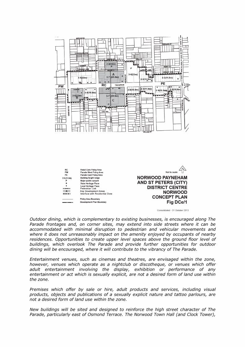
Outdoor dining, which is complementary to existing businesses, is encouraged along The Parade frontages and, on corner sites, may extend into side streets where it can be accommodated with minimal disruption to pedestrian and vehicular movements and where it does not unreasonably impact on the amenity enjoyed by occupants of nearby residences. Opportunities to create upper level spaces above the ground floor level of buildings, which overlook The Parade and provide further opportunities for outdoor
dining will be encouraged, where it will contribute to the vibrancy of The Parade. Entertainment venues, such as cinemas and theatres, are envisaged within the zone, however, venues which operate as a nightclub or discotheque, or venues which offer adult entertainment involving the display, exhibition or performance of any entertainment or act which is sexually explicit, are not a desired form of land use within the zone.
Premises which offer by sale or hire, adult products and services, including visual products, objects and publications of a sexually explicit nature and tattoo parlours, are not a desired form of land use within the zone. New buildings will be sited and designed to reinforce the high street character of The Parade, particularly east of Osmond Terrace. The Norwood Town Hall (and Clock Tower),
the Norwood Hotel at the corner of Osmond Terrace and The Parade and the spires of the former church and church on the northern corners of the intersection of The Parade and Portrush Road, will remain as prominent visual elements along The Parade.
A range of building heights is anticipated within the Zone. East of Osmond Terrace, building heights will be guided by the range of heights indicated on Concept Plan Fig DCe/1 and further detailed on Concept Plans Fig DCe/2, Fig DCe/3 and Fig DCe/4. The scale and massing of taller building elements within the Zone will be designed having regard to the visual, overlooking and overshadowing impacts on residential properties in adjacent Residential Zones, whilst recognising that there is a need to carefully balance the level of amenity expected by nearby residents, with the nature of development desired within the Zone. The character of The Parade will be reinforced by a well-defined low to medium scale built form edge abutting the footpath and continuing the established width, rhythm and pattern of facades that generally support a variety of tenancies with narrow frontages.
To maintain a human scale at street level, the upper levels of buildings will be recessed behind the dominant two (2) and three (3) storey podium/street wall heights. Although demolition control of existing shopfronts and facades which are not identified as State or Local Heritage Places is not legislated, where they contribute to the historical built form character of The Parade, their integration into new development is a desirable outcome. The scale, siting and design of new development will be influenced by the desire to maintain the prominence and integrity of adjacent or abutting State or Local Heritage Places and in some cases, may temper the ability to achieve the minimum and/or maximum allowable building parameters. The front and side elevations of buildings (or portions of buildings) fronting The Parade and extending into adjacent side streets, will incorporate materials and finishes of a high quality and complement (without replicating) the materials and finishes used in the historic building fabric and will avoid visible expanses of tilt-up concrete walling. Shopfronts will incorporate visible entry foyers and display windows and will not be secured through the use of roller shutters. The creation of new vehicle access points from The Parade is not desired and where possible, vehicle access should be from side streets and rear access lanes. The level of
public car parking spaces will be increased over time, particularly in association with any expansion of development within the Retail Core, to ensure that good accessibility to The Parade as a destination location is maintained. Pedestrian movement in the District Centre (Norwood) Zone will continue to be concentrated along The Parade frontages and along the north/south pedestrian ways linking the Webbe Street car park to the north and James Coke Park to the south.
Development will ensure that pedestrian movement is not unduly obstructed by the placement of either fixed or moveable items on footpaths or along pedestrian access ways. The existing open nature of the pedestrian link on the southern side of The Parade will be maintained. Development will enhance the pedestrian environment of The Parade and adjacent
secondary streets, with verandahs, pergolas and awnings extending over the footpath, to provide pedestrian protection and achieve a human scale and a visually interesting environment. Where there is a dominant existing verandah height, this will be continued by new development. Where possible, structures over the footpath will be cantilevered to minimise the potential for damage from vehicles and the like.

Cycling is an increasingly popular form of transport and recreation, therefore development on public and private land will consider the needs of cyclists, in terms of providing secure bicycle parking and storage facilities and creating linkages through the District Centre, which can be shared safely by both pedestrians and cyclists. Larger scale
commercial developments will also provide appropriate end of journey facilities such as showers and change rooms. Land Use 1 The following forms of development are envisaged in the zone: Affordable housing Aged persons accommodation (but not including a nursing home) Bank Child care centre Civic centre Consulting room
Discount department store (only within the Retail Core Policy Area) Dwellings above ground level Educational establishment Entertainment venue (but not including nightclubs, discotheques and adult entertainment premises) Hotel Indoor recreation centre (including health, fitness and personal training facilities) Library Licensed premises (but not including nightclubs, discotheques and adult entertainment premises) Office Place of worship Pre-school Primary school Restaurant Serviced apartments Shop or group of shops Student accommodation Supported accommodation Supermarket (only within the Retail Core Policy Area)
Tourist accommodation. 2 Development listed as non complying is generally inappropriate. 3 Development should complement the function of the zone as a district wide
centre for retailing, comprising primarily ground floor retailing, with other business uses and residential uses located above ground level and at the
periphery of the zone. 5 Where a development comprises more than two (2) storeys above natural ground
level, the levels above the ground and first floor levels should comprise residential accommodation (which may include serviced apartments).
5 Where residential accommodation above ground floor level non-residential uses is proposed, the average floor area of the residential component should not exceed 100 square metres per dwelling.
Form and Character 6 Development should be consistent with the desired character for the zone.

7 The height of buildings and structures should be consistent with the heights
specified in the relevant policy area and as indicated on Concept Plan Fig DCe/1.
10 Development located above the maximum allowable podium/street wall height should be set back from the street wall boundary in order to: (a) Reinforce a lower scale (2 or 3 storey) building form along the primary and
secondary street frontages (b) Minimise overshadowing of the public realm; and (c) Maintain the prominence and integrity of heritage buildings; And in order to achieve these aims, the set-back should generally be in the order of 6 metres from the street wall boundary.
11 The front set-back of new buildings at ground level should maintain the traditional
pattern of development abutting street boundaries to define the street space.
12 Pedestrian spaces should be developed with an open character, which includes
high quality landscaping, and along public street frontages should incorporate pedestrian shelter.
13 New buildings located along The Parade and extending into adjacent side streets, should include a verandah or canopy structure (cantilevered where possible) over the footpath, which avoids damage or interference with the growth of street trees and should be of a height consistent with the verandah or canopy of adjacent buildings.
14 The finished floor level of the ground floor of buildings and any associated outdoor dining areas, should be the same as the level of the adjacent footpath and stepped where required, to enable all access points to match the existing footpath level.
15 The ground level facades of non-residential or mixed-use buildings should incorporate materials which are transparent or glazed a minimum of 50% of the width of the façade and should not be secured with roller shutters, to promote active street frontages and maximise passive surveillance.
16 On-site car parking should be provided behind, below, or above uses on the
ground floor of buildings which front The Parade. Where this is not possible, it should not interrupt the continuity of the streetscape or pedestrian movements and should be screened from the street.
The Parade East Policy Area
Objective 1: Development providing specialty shops, restaurants, cafes, offices,
consulting rooms, recreation and community facilities, together with medium to high density residential development.
Objective 2: Development that contributes to the desired character for the
policy area. DESIRED CHARACTER The Parade East Policy Area provides for small-scale retailing, restaurants, offices, consulting rooms, recreation and community facilities, which extend at a lower intensity than the activity of the adjoining Retail Core Policy Area. The Policy Area will continue to

provide non-residential activity at ground level, with opportunities for residential land uses above ground level. Development should respect the heritage and streetscape significance of historic
buildings on The Parade, in particular the State Heritage listed former church and church buildings located on the northern corners of the intersection of Portrush Road and The Parade. It is expected that any redevelopment of the former Water Tower site will seek to improve the amenity of residents in Cairns Street, in terms of reducing the current level of overshadowing and visual amenity impacts associated with the existing structure. Development should achieve consolidated car parking areas at the rear of properties facing The Parade, with the preferred access being from Queen Street and rear laneways. 1 Development should be consistent with the desired character for the policy area.
2 Development should be consistent with the range of building heights shown on
Concept Plan FigDCe/1.
3 Development should maintain a pedestrian scale at street level and should include a clearly defined podium or street wall fronting The Parade (and extending into side streets) with a maximum building height of 2 storeys or 8 metres.
CITY WIDE Orderly and Sustainable Development Objective 1: Orderly and economic development that creates a safe, convenient
and pleasant environment in which to live.
Objective 2: A proper distribution of living, working and recreational activities by the allocation of suitable areas of land for those purposes.
Objective 3: The provision of such facilities as are required for accommodation,
employment, recreation, health and welfare
Objective 5: Development occurring in an orderly and compact form to support
the efficient provision of public services and community facilities. Objective 7: Rational distribution of land uses to avoid incompatibility between
them.
Objective 8: Compatibility of new buildings with the desired environment around them
Objective 11: Provision of a choice of lifestyles within the law and custom of the
community.
Objective 12: Maintenance and increase of employment opportunities. Objective 13: Provision of services to encourage and provide for visitors to the
City. 1 Development should be orderly and economic.
2 Development should: (a) form a compact and continuous extension of an existing built-up area;
(b) be located to achieve economy in the provision and use of public services and infrastructure; and (c) create a safe, convenient and pleasant place to live.
3 Development should take place on land which is suitable for the intended use of that land, having regard to the location and condition of that land and the provisions for the relevant Zone and Policy Area.
4 Development should take place in a manner which will not: (a) interfere with the effective and proper use of any other land; and
(b) prevent the attainment of the objectives for that other land.
5 Development should be undertaken in accordance with the Norwood Payneham and St Peters (City) Structure Plan, Map NPSP/1 (Overlay 1) Parts A & B.
6 Development should not take place excessively in advance of a demonstrated need for the use for which it provides.
7 Development should be located and take place with reasonable and effective precautions being taken against hazards from fire and flooding.
8 Buildings and structures should not adversely affect, by way of their height and location, the long term operational, safety and commercial aviation requirements of Adelaide International Airport and Parafield Airport.
11 Buildings should be designed so as not to unreasonably overlook or overshadow
indoor or outdoor living areas of adjacent dwellings.
12 Development should take place in a manner which is not liable to cause an unreasonable nuisance to neighbours or the community or significantly detrimentally affect the amenity, use or enjoyment of nearby properties by: (a) the emission beyond the site boundaries of noise, vibration, odour, atmospheric liquid or other pollutants, waste water, waste products, electrical interference, light overspill or loss of privacy; or (b) stormwater or the drainage of run-off from the land.
16 Land used for the erection of buildings should be stable. 19 Vacant or underutilised land should be developed in an efficient and co-ordinated
manner so as to not prejudice the orderly development of adjacent land.
Design and Appearance of Land and Buildings Objective 18: The amenity of localities not impaired by the appearance of land,
buildings and objects.

Objective 19: Development of a high architectural standard and appearance that responds to and reinforces positive aspects of the local environment and built form.
Objective 20: Architectural excellence allowing for design innovation consistent with sound design principles.
29 The appearance of land and buildings should not impair the amenity of the
locality in which they are situated.
31 Buildings should be designed to minimise their visual bulk and provide visual interest through design elements such as: (a) articulation; (b) colour and detailing;
(c) materials, patterns, textures and decorative elements; (d) vertical and horizontal components; (e) design and placement of windows; (f) window and door proportions; (g) roof form and pitch; (h) verandahs and eaves; and (i) variations to facades.
32 The design and location of buildings should ensure that adequate natural light is available to adjacent dwellings, with particular consideration given to: (a) windows of habitable rooms, particularly the living areas of adjacent buildings;
(b) ground-level private open space of adjacent dwellings; (c) upper level private balconies that provide the primary open space area for any dwelling; and (d) access to solar energy.
33 The height of buildings, structures and associated component parts should not exceed the number of storeys or height in metres above the natural ground level prescribed in the relevant Zone and/or Policy Area.
35 Buildings should be designed and sited to avoid creating extensive areas of uninterrupted walls facing areas exposed to public view.
38 Balconies should:
(a) be integrated with the overall architectural form and detail of the building; (b) be sited to face predominantly north or east to provide solar access;

(c) be self-draining and plumbed to minimise runoff; and (d) be recessed where wind would otherwise make the space unusable.
39 The external walls and roofs of buildings should not incorporate highly reflective materials which will result in excessive glare.
40 Structures located on the roofs of buildings to house plant and equipment, should be screened from view and should form an integral part of the building design in relation to external finishes, shaping and colours.
41 Building design should emphasise all pedestrian entry points to provide all users with perceptible and direct access from public street frontages and vehicle parking areas.
42 Buildings, landscaping, paving and signage should have a coordinated appearance that maintains and enhances the visual attractiveness of the locality.
43 Buildings (other than ancillary buildings, group dwellings or buildings located on
hammerhead, battleaxe or similar configuration allotments) should be designed so that their main facade faces the primary street frontage of the land on which they are situated.
44 Development should be designed and sited so that outdoor storage, loading and service areas, fire escapes and plant and equipment hatches are screened from public view through the use of an appropriate combination of built form, solid fencing and/or landscaping.
45 Outdoor storage, loading and service areas should be located and designed to
enable the convenient manoeuvring of service and delivery vehicles and sited away from sensitive land uses.
48 Development should not, in respect to its appearance, interfere with the
attainment of the Objectives for the relevant Zone or Policy Area or otherwise impact upon the existing character of scenic or environmentally important areas.
49 Outdoor lighting should not result in light spillage on adjacent land.
Crime Prevention 62 Development should be designed to maximise surveillance of public spaces
through the incorporation of clear lines of sight, appropriate lighting and the use of visible permeable barriers wherever practicable.
63 Buildings should be designed to overlook public and communal open spaces and streets to allow casual surveillance.
64 Buildings should be designed to minimise and discourage access between roofs,
balconies and windows of adjoining dwellings.
65 Development, including car park facilities should incorporate signage and lighting that indicate the entrances and pathways to, from and within the site.
66 Site planning, buildings, fences, landscaping and other features should clearly
differentiate between public, communal and private areas.
67 Development should avoid pedestrian entrapment spots and routes and paths that are predictable or unchangeable and offer no choice to pedestrians.
68 Development fronting an alleyway, laneway (including a service lane), or other
minor or unserviced street should be located and designed to maximise safety and security.
69 Development fronting a laneway (including a service lane), or other minor or unserviced street should maximise the potential for passive surveillance by ensuring that the building can be seen from nearby buildings and the laneway/minor streets/unserviced streets.
Energy Efficiency Objective 23: Development designed and sited to conserve energy and minimise
waste.
70 Development should provide for efficient solar access to buildings and open space all year round.
71 Buildings should be sited and designed to ensure: (a) that the main living areas and the private open space associated with the main living areas, face north to maximise exposure to winter sun; and (b) adequate natural light and winter sunlight is available to the main internal living areas and principal private open spaces of adjacent properties.
72 Development should be designed to minimise energy consumption by incorporating, where practicable, energy efficient building design elements, techniques and materials, such as: (a) the sizing, orientation and shading of windows to reduce summer heat load and take advantage of winter sun; (b) the use of deciduous trees, pergolas, eaves, verandas and awnings, to allow penetration of heat and light from the sun in winter and to provide shade in
summer; (c) openings designed to maximise the potential for natural cross-ventilation to enable cooling breezes to reduce internal temperatures in the summer months; or (d) the use of colours on external surfaces such as roofs and walls, to minimise energy consumption.
On-Site Energy Generation 73 Development should facilitate the efficient use of solar collectors, such as solar
hot water systems and photovoltaic cells by:
(a) taking into account overshadowing from neighbouring buildings and trees; and (b) designing roof orientation and pitch to maximise exposure to direct sunlight.
74 Development should maintain solar access, for a minimum of 3 hours between 9am and 3pm on 21 June, to:

(a) any existing solar collectors (such as solar hot water systems and photovoltaic cells) on adjoining properties; or
(b) an area of at least 10m² on the north facing roof of the existing building/s, in the event that there are no existing solar panels and/or photovoltaic cells on the adjoining property. Development should not increase the overshadowed area by more than 20 percent in cases where overshadowing already exceeds these requirements.
75 Development should not incorporate vegetation or landscape elements which are likely to overshadow existing or proposed solar collectors (including solar hot water systems and photovoltaic cells).
Landscaping, Fences and Walls
Objective 24: The amenity of land and development enhanced with appropriate planting and landscaping, which uses locally indigenous plant species where possible.
Objective 25: Functional fences and walls that enhance the attractiveness of development
Landscaping 76 Development should incorporate open space and landscaping and minimise the
use of hard paved surfaces in order to: (a) complement built form and reduce the visual impact of larger buildings (for example locating taller and broader plants against taller and bulkier building components); (b) enhance the visual appearance from the street frontage; (c) screen service yards, loading areas and outdoor storage areas; (d) define and enhance the appearance of outdoor spaces, including car parking
areas; (e) minimise heat absorption and reflection; (f) provide shade and shelter; (g) assist in climate control within and around buildings;
(h) allow for natural infiltration of surface waters through permeable treatments; (i) contribute to the viability of ecosystems and species; and (j) promote water and biodiversity conservation.
77 Landscaped areas should:
(a) where practicable, have a width of not less than two metres; (b) be protected from damage by vehicles and pedestrians;
(c) result in the appropriate clearance from powerlines and other infrastructure being maintained; (d) be designed to incorporate the re-use of stormwater for irrigation purposes;
and (e) include the planting of locally indigenous species where practical.
78 Landscaping should be used to assist in discouraging crime by:
(a) screen planting areas susceptible to vandalism; (b) planting trees or ground covers, rather than shrubs, alongside footpaths; and (c) planting vegetation other than ground covers a minimum distance of two metres from footpaths to reduce concealment opportunities.
79 Landscaping of non-residential development should be provided and maintained in order to: (a) establish a buffer between the non-residential development and the development on adjacent sites; (b) complement the landscaping provided by adjacent development and enhance the visual appearance and character of the area; (c) shade, define and create windbreaks for pedestrian paths and spaces; (d) screen, shade and enhance the appearance of car parking areas; (e) screen service yards, loading areas and outdoor storage areas; and (f) re-establish local indigenous plant species where it is practical to do so.
81 Landscaping should not:
(a) unreasonably restrict solar access to adjoining development;
(b) cause damage to buildings, paths, infrastructure/services and other landscaping from root invasion, soil disturbance or plant overcrowding; (c) remove opportunities for passive surveillance; (d) increase leaf fall into watercourses; and
(e) introduce pest plants and/or increase the risk of weed invasion.
Fences and Walls 82 Fences and walls, including retaining walls, should:
(a) not result in damage to neighbouring trees; (b) be compatible with the associated development and with existing predominant, attractive fences and walls in the locality;

(c) enable some visibility of buildings from and to the street or laneway (only where it is the primary street) to allow casual surveillance; (d) incorporate articulation or other detailing, where there is a large expanse of
wall facing the street; (e) assist in highlighting building entrances; (f) be sited and limited in height, to ensure adequate sight lines for motorists and pedestrians especially on corner sites; (g) in the case of side and rear boundaries, be of sufficient height to maintain privacy and/or security without adversely affecting the visual amenity or access to sunlight of adjoining land; and (h) be constructed of non-flammable materials.
Interface between Land Uses Objective 27: Protect community health and amenity from the adverse impacts of
development and support the continued operation of all desired land uses
84 Residential development adjacent to a non-residential land use or zone or within
a non-residential zone should be located, designed and sited in a manner which: (a) protects residents from any adverse effects of non-residential activities; and (b) minimises negative impact on existing and potential future land uses considered appropriate in the locality.
85 Non-residential development in residential zones should: (a) not detrimentally impact on the amenity of nearby residents; (b) provide adequate protection for residents of adjoining sites from air and noise pollution, traffic disturbance and other harmful effects on health or amenity; and
(c) not negatively impact on adjoining open space, mature trees or vegetation.
Noise Generating Activities 89 Development that emits noise (other than music noise) should include noise
attenuation measures that achieve the relevant Environment Protection (Noise)
Policy criteria when assessed at the nearest existing noise sensitive premises. Movement, Transport and Car Parking Objective 28: A comprehensive, integrated and efficient public and private
transport system which will:
(a) provide access to adequate transport services for all people, at an acceptable cost;
(b) effectively support the economic development of metropolitan Adelaide and the State;
(c) ensure a high level of safety; and
(d) maintain the options for the introduction of suitable new transport technologies.
Objective 29: A road hierarchy to form the basis of development controls and
serve as a guide to the investment of road funds in order to ensure a safe and efficient traffic flow and to promote the saving of fuel and time. Arterial roads will provide for major traffic movements.
Objective 30: A safe, convenient and clearly defined network of roads, paths and
tracks throughout the City that also links to networks beyond the City and accommodates a variety of vehicular, cycle and pedestrian traffic.
Objective 31: A compatible arrangement between land uses and the transport
system which will:
(a) ensure minimal noise and air pollution;
(b) protect amenity of existing and future land uses;
(c) provide adequate access; and
(d) ensure maximum safety.
Objective 32: A form of development adjoining main roads which will:
(a) ensure traffic can move efficiently and safely;
(b) discourage commercial ribbon development;
(c) prevent large traffic-generating uses outside designated shopping/centre zones;
(d) provide for adequate off-street parking; and
(e) provide limited and safe points of access and egress. Objective 33: Control of the movement of traffic according to a defined hierarchy
of roads which seeks to improve safety and to limit the speed and volume of traffic in local residential streets without unreasonably restricting access opportunities.
Objective 34: Development which provides adequate and safe car parking appropriate to the demands generated.
Objective 35: Provision of an effective public transport system to facilitate travel
to, from and within the City.
Land Use 95 Land uses arranged to support the efficient provision of sustainable transport
networks and encourage their use.
Movement Systems

96 Development should be integrated with existing transport networks, particularly major rail, road and public transport corridors, and designed to minimise its potential impact on the functional performance of the transport network.
98 Land uses that generate large numbers of visitors such as shopping centres, places of employment, schools, hospitals and medium to high density residential uses should be located so that they can be serviced by the public transport network and encourage walking and cycling.
101 Development should provide safe and convenient access for all anticipated modes of transport
104 Driveway crossovers should be appropriately separated and the number
minimised to maintain streetscape character, preserve street trees and optimise the provision of on-street visitor parking (where on-street parking is appropriate)
106 Industrial/commercial vehicle movements should be separated from passenger
vehicle car parking areas.
107 Development should include appropriate on-site provision to enable the parking, loading, unloading, turning and fuelling of vehicles.
Cycling and Walking 108 Development should ensure that a permeable street and path network is
established that encourages walking and cycling through the provision of safe, convenient and attractive routes with connections to adjoining streets, paths, open spaces, schools, pedestrian crossing points on arterial roads, public and community transport stops and activity centres.
109 Development should provide access, and accommodate multiple route options, for pedestrians and cyclists by enhancing and integrating with: (a) open space networks, recreational trails, parks, reserves, and sport and
recreation
(b) Adelaide’s principal cycling network (Bikedirect), which includes arterial
roads, local roads and off-road paths.
110 New developments should give priority to and not compromise existing designated bicycle routes.
112 Development should encourage and facilitate cycling as a mode of transport by incorporating end-of journey facilities including:
(a) showers, changing facilities and secure lockers; (b) signage indicating the location of bicycle facilities; and (c) bicycle parking facilities provided at the rate set out in Table NPSP/10
113 On-site secure bicycle parking facilities should be:
(a) located in a prominent place; (b) located at ground floor level;

(c) located undercover; (d) located where surveillance is possible;
(e) well lit and well signed; (f) close to well used entrances; and (g) accessible by cycling along a safe, well lit route.
114 Pedestrian and cycling facilities and networks should be designed and provided in accordance with relevant provisions of the Australian Standards and Austroads Guides.
Access 115 Development should have direct access from an all-weather public road.
116 Development should be provided with safe and convenient access which:
(a) avoids unreasonable interference with the flow of traffic on adjoining roads; (b) provides appropriate separation distances from existing roads or level crossings; (c) accommodates the type and volume of traffic likely to be generated by the development or land use and minimises induced traffic through over-provision; and (d) is sited and designed to minimise any adverse impacts on the occupants of and visitors to neighbouring properties.
118 On-site parking and manoeuvring areas servicing development abutting arterial roads should be designed to enable all vehicles to enter and exit the site in a forward direction.
119 Structures such as canopies and balconies that encroach onto the footpath of an
arterial road should not cause visual or physical obstruction to: (a) signalised intersections; (b) heavy vehicles; (c) street lighting;
(d) overhead electricity lines; (e) street trees; or (f) bus stops.
120 Driveways and parking areas should be designed and constructed to:
(a) follow the natural contours of the land; (b) minimise excavation and/or fill;

(c) minimise the potential for erosion from surface runoff; (d) avoid the removal of existing vegetation, including street trees; and
(e) be consistent with Australian Standard AS: 2890 – Parking facilities.
121 Driveways should: (a) not exceed a gradient of 1 in 5 at any point and have a near level gradient (of 1 in 20) at either end for a length of at least 5 metres and connect to any existing paved footpath surface at a level that does not require any modification to the level of any public infrastructure; (b) be designed, located and constructed in a manner which enables safe and convenient access, with surfaces providing adequate traction for the wheels of vehicles; and
(c) be designed and located so that they are not constructed closer than 1.5 metres to any street tree.
Access for People with Disabilities 122 Development should be sited and designed to provide convenient access for
people with a disability. Vehicle Parking 123 Development should provide off-street vehicle parking in accordance with rates
contained in Tables NPSP/8 and 9 125 Within the Urban Corridor Zone and the District Centre (Norwood) Zone, a lesser
on-site car parking rate may be applied to applicable elements of a development in any of the following circumstances: (a) development includes affordable housing or student accommodation; or (b) sites are located within 200 metres walking distance of a convenient and
frequent service fixed public transport stop; or (c) mixed use development including residential and non-residential development has respective peak demands for parking occurring at different times; or (d) the proposed development is on or adjacent to the site of a heritage place, or includes retention of a desired traditional building and its features, which hinders
the provision of on-site parking or the most effective use of the spaces within the site; (e) the parking shortfall is met by contribution to a Car Parking Fund (where one is available); or
(f) the development qualifies for certification under the Green Energy rating program, or similar program.
126 Development should provide carparking which is consistent with Australian
Standard AS: 2890 - Parking facilities.
127 Vehicle parking areas should be sited and designed to:

(a) facilitate safe and convenient pedestrian linkages to the development and areas of significant activity or interest in the vicinity of the development;
(b) include safe pedestrian and bicycle linkages that complement the overall pedestrian and cycling network; (c) not inhibit safe and convenient traffic circulation; (d) result in minimal conflict between customer and service vehicles; (e) avoid the necessity to use public roads when moving from one part of a parking area to another; (f) minimise the number of vehicle access points onto public roads; (g) avoid the need for vehicles to reverse onto public roads;
(h) where practical, provide the opportunity for shared use of car parking and integration of car parking areas with adjoining development to reduce the total extent of vehicle parking areas and the requirement for access points; (i) not dominate the character and appearance of the development when viewed from public roads or spaces; (j) provide landscaping that will shade and enhance the appearance of the vehicle parking areas; and (k) where practicable, include infrastructure such as underground cabling and connections to power infrastructure that will enable the recharging of electric vehicles.
129 Vehicle parking areas that are likely to be used during non-daylight hours should provide floodlit entry and exit points and site lighting directed and shaded in a manner that will not cause nuisance to adjacent properties or users of the parking area.
130 Vehicle parking areas should be sealed or paved to minimise dust and mud nuisance.
132 Vehicle parking areas should be line-marked to delineate parking bays,
movement aisles and direction of traffic flow.
133 On-site visitor parking spaces should be sited and designed to:
(a) not dominate internal site layout; (b) be clearly defined as visitor spaces not specifically associated with any particular dwelling; and
(c) be accessible to visitors at all times.
Vehicle Parking for Mixed Use and Corridor Zones
134 Loading areas and designated parking spaces for service vehicles should: (a) be provided within the boundary of the site; and

(b) not be located in areas where there is parking provided for any other purpose.
135 Vehicle parking spaces and multi-level vehicle parking structures within buildings
should: (a) enhance active street frontages by providing land uses such as commercial, retail or other non-car park uses along ground floor street frontages; (b) complement the surrounding built form in terms of height, massing and scale; and (c) incorporate facade treatments along major street frontages that are sufficiently enclosed and detailed to complement neighbouring buildings consistent with the desired character of the locality.
136 In mixed use buildings, the provision of vehicle parking may be reduced in
number and shared where the operating hours of commercial activities complement the residential use of the site.
Infrastructure Objective 37: The efficient and cost-effective use of existing infrastructure.
Objective 38: Infrastructure provided in an economical and environmentally
sensitive manner Objective 41: The visual impact of infrastructure facilities minimised. 138 Development should not occur without the provision of adequate utilities and
services, including: (a) electricity supply; (b) water supply; (c) drainage and stormwater systems;
(d) waste disposal; (e) effluent disposal systems; (f) formed all-weather public roads;
(g) telecommunications services; (h) social infrastructure, community services and facilities; and (i) gas service.
139 Electricity supply serving new development should be installed underground.
140 Development should provide for the suitable drainage of stormwater either into the public stormwater system or using alternative methods of stormwater control (including the collection and re-use of water), where appropriate standards can be satisfied.
141 The treatment and disposal of effluent and other waste material from any development or use of land should, having regard to the location or design of the development or use, be able to be achieved without risk to health or impairment to the environment.
142 Development should incorporate provision for the supply of infrastructure services
to be located within common service trenches, where practical.
143 Development should not take place until adequate and coordinated drainage of land is assured.
144 Development should enable economic and effective servicing for public transport, recycling and waste collection, fire protection and street lighting.
Residential Development Objective 55: Safe, pleasant, convenient, and healthy-living environments that
meet the full range of needs and preferences of the community.
Objective 56: An increased mix in the range and number of dwelling types available within the City to cater for changing demographics, particularly smaller household sizes, housing for seniors and supported accommodation.
Objective 57: Increased dwelling densities in areas close to centres, public
transport and significant public open spaces.
Objective 58: The retention and rehabilitation of structurally sound housing that contributes to the desired character of a location, on land suitable for residential use.
Objective 59: Affordable housing and housing for seniors provided in appropriate
locations.
Medium and High Rise Development (3 or more storeys) Objective 60: Medium and high rise development that provides housing choice
and employment opportunities.
Objective 61: Residential development that provides a high standard of amenity and adaptability for a variety of accommodation and living needs.
Objective 62: Commercial, office and retail development that is designed to
create a strong visual connection to the public realm and that
contributes to the vitality of the locality.
Objective 63: Buildings designed and sited to be energy and water efficient. Design and Appearance
287 Buildings should: (a) achieve a human scale at ground level through the use of elements such as canopies, verandahs or building projections; (b) provide shelter over the footpath where minimal setbacks are desirable; and

(c) ensure walls on the boundary that are visible from public land include visually interesting treatments to break up large blank facades.
288 The ground floor level of buildings (including the foyer areas of residential
buildings) should be designed to enable surveillance from public land to the inside of the building at night.
289 Entrances to multi-storey buildings should: (a) be oriented towards the street; (b) be clearly identifiable; (c) provide shelter, a sense of personal address and transitional space around the entry; and (d) provide separate access for residential and non-residential land uses.
Visual Privacy 290 The visual privacy of ground floor dwellings within multi-storey buildings should
be protected through the use of design features such as the elevation of ground floors above street level, setbacks from the street and the location of verandahs, windows, porticos or the like
Building Separation and Outlook 291 Residential buildings (or the residential floors of mixed use buildings) should:
(a) have adequate separation between habitable room windows and balconies from other buildings to provide visual and acoustic privacy for dwelling occupants and allow the infiltration of daylight into interior and outdoor spaces; and
(b) ensure living rooms have, at a minimum, a satisfactory short range visual outlook to public or communal space.
Dwelling Configuration
292 Buildings comprising more than 20 dwellings should provide a variety of dwelling
sizes and a range in the number of bedrooms per dwelling.
293 Dwellings with three or more bedrooms located on the ground floor of medium and high rise buildings should, where possible, have the windows of habitable rooms overlooking internal courtyard space or other public space.
Adaptability 294 Multi-storey buildings should include a variety of internal designs that will
facilitate adaptive reuse.
Environmental 295 Multi-storey buildings should:
(a) minimise detrimental micro-climatic and solar access impacts on adjacent land or buildings, including effects of patterns of wind, temperature, daylight, sunlight, glare and shadow; and

(b) incorporate roof designs that enable the provision of rain water tanks (where they are not provided elsewhere), photovoltaic cells and other features that enhance sustainability.
296 Green roofs (which can be a substitute for private or communal open space
provided they can be accessed by occupants of the building) are encouraged on all new residential, commercial or mixed use buildings.
297 Development of five or more storeys, or 18.5 metres or more in building height (excluding the rooftop location of mechanical plant and equipment), should be designed to minimise the risk of wind tunnelling effects on adjacent streets by adopting one or more of the following: (a) a podium at the base of a tall tower which is aligned with the street to deflect wind away from the street;
(b) substantial verandahs around a building to deflect downward travelling wind flows over pedestrian areas; or (c) the placement of buildings and use of setbacks to deflect the wind at ground level.
Site facilities and storage 298 Each dwelling within a multi-storey building should provide a covered storage
area of not less than 8 cubic metres in one or more of the following areas: (a) in the dwelling (but not including a habitable room); (b) in a garage, carport or outbuilding; or (c) within an on-site communal facility.
299 The design of driveway crossovers, parking areas, accessways and elements that interact with the public realm should safely and efficiently accommodate the collection of waste and recycling materials.
300 Development should provide a dedicated area for the on-site storage, collection
and sorting of recyclable materials and waste that is consistent with the following: (a) easily and safely accessible to the collection point;
(b) easily and safely accessible to residents and collection service providers; (c) well screened to prevent vandalism and theft; and (d) designed to reduce odour and discourage vermin.
301 Development with a gross floor area of 2000 square metres or more should provide for the communal storage, collection and management of waste.
Affordable Housing Overlay Objective 1: Affordable housing that is integrated into residential and mixed use
development.
Objective 2: Development that comprises a range of affordable dwelling types
that caters for a variety of household structures.
1 Development comprising 20 or more dwellings should include a minimum of 15 percent affordable housing (as defined by the South Australian Housing Trust Regulations 2010 as amended), unless it can be demonstrated that any shortfall in affordable housing from a preceding stage of development will be accommodated in as subsequent stage or stages.
Noise and Air Emissions Overlay Objective 1: Protect community health and amenity from adverse impacts of
noise and air emissions.
1 Noise and air quality sensitive development located adjacent to high noise and/or air pollution sources should:
(a) shield sensitive uses and areas through one or more of the following measures: (i) placing buildings containing less sensitive uses between the emission source and sensitive land uses and areas; (ii) within individual buildings, place rooms more sensitive to air quality and noise impacts (e.g. bedrooms) further away from the emission source; (iii) erecting noise attenuation barriers provided the requirements for safety, urban design and access can be met; (b) use building design elements such as varying building heights, widths, articulation, setbacks and shapes to increase wind turbulence and the dispersion of air pollutants provided wind impacts on pedestrian amenity are acceptable; and (c) locate ground level private open space, communal open space and outdoor play areas within educational establishments (including childcare centres) away from the emission source

freemae
Polygon
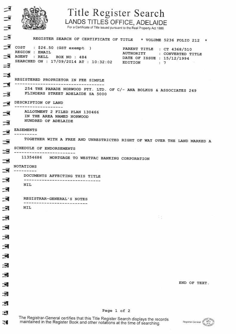
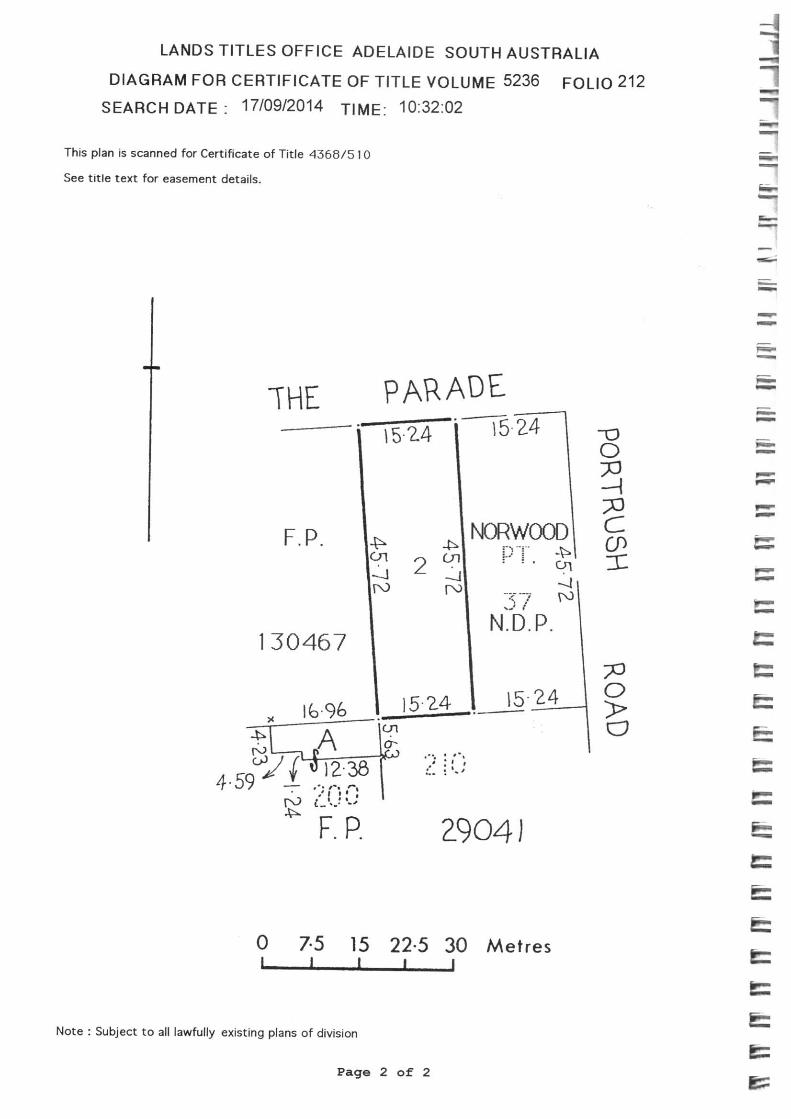
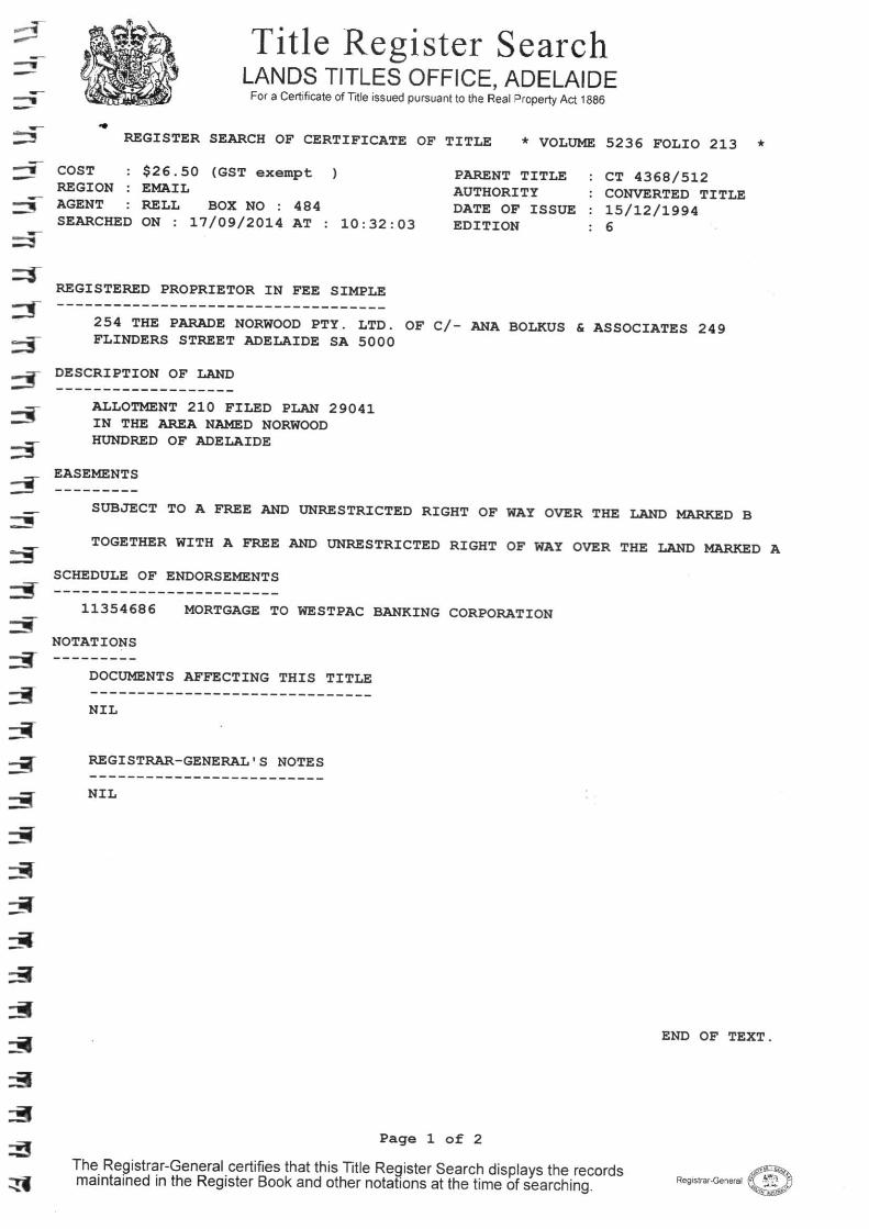


This brochure provides summary information on clearances from powerlines and tips on when it’s OK to sign the declaration form.
To protect people and property, minimum safe clearances from powerlines have been established in the Regulations under the Electricity Act 1996. The declaration form requires applicants to confirm that their development will meet these safe clearances.
The vast majority of applications will not have any powerline issues as normal residential setbacks often cause the building to comply with the clearance distances prescribed by the Electricity Act.
Particular care needs, however, to be taken for developments on major roads, commercial/industrial developments and in other cases where higher voltage powerlines exist.
Even if the proposed location of your building is closer than the clearances outlined in this brochure, it may still be compliant with the Regulations under the Electricity Act 1996. Please see our brochure ‘Building Safely Near Powerlines’ for more details or contact the Office of the Technical Regulator. You may be required to obtain additional information from the Electricity Supplier for a nominal fee, including the maximum worst case swing and sag of the powerline.
Swimming pools are considered to be structures and are not permitted within the clearance zone. It is unsafe to locate a swimming pool under any powerline.
These legislated clearance distances are not the same as electricity distribution or transmission company easements for access to the powerlines.
If there is an easement for electricity supply purposes registered on your Certificate of Title you must ensure that the proposed location of your building does not encroach on the easement area. If your proposal will encroach on the
easement area you will also need to approach ETSA Utilities or ElectraNet to seek approval for your proposal.
Overhead Powerlines
The minimum safe clearance between powerlines and buildings depends on the voltage of the powerline and the type of conductor. The different types of powerlines can usually be recognised from their construction, however, check with ETSA Utilities if you are not sure what the powerline voltage is. The Technical Regulator website contains a list of personnel at ETSA Utilities who can be contacted for voltage identification.
Most metropolitan streets contain only low voltage, or low voltage and 11 000 volt powerlines. In these cases, if your development will be more than 3.1 metres horizontally away it is OK to sign the declaration form.
POWERLINE CLEARANCE DECLARATION GUIDE
Issue 20070112
OK TO SIGN
Low Voltage and 11 000 volts
Greater than 3.1 metres from closest conductor

In rural areas, a SWER (single wire earth return) powerline is commonly used, and this has a voltage of 19 000 volts. Due to the long span lengths (distance between poles) of SWER lines, it is necessary to include additional clearance distances. If there is a SWER line near your proposed development and your building will be more than 15 metres away from the powerline, then it is OK to sign the declaration form.
Some higher voltage (e.g. 66 000 volts and 132 000 volts) powerlines are on very tall stobie poles—around 15 metres or higher. If you are near one of these powerlines and your building will be more than 15 metres away from the centreline of the poles, then it is OK to sign the declaration form.
Transmission lines are very high voltage powerlines that carry electricity from power stations to major substations, or between major substations. These are normally seen in country areas or on the outskirts of towns.
If there are transmission towers near your proposed development and your building will be more than 25 metres away from the centreline of the powerline, then it is OK to sign the declaration form.
Underground Powerlines
If you are planning to build in an area where there are underground powerlines, you should contact Dial Before You Dig on telephone 1100 before starting any excavation.
It is a requirement that underground powerlines are more than 3 metres away from buildings. This does not include underground powerline lines directly supplying power to the building. Unless your building is right on the front boundary of your property or there is an electricity easement on your property, it is probably OK to sign the declaration form.
For further information refer to the brochure Building Safely Near Powerlines, available from:
www.technicalregulator.sa.gov.au
Or call the Office of the Technical Regulator on (08) 8226 5500
Greater than 3.1 metres from conductor
OK TO SIGN
OK TO SIGN
Greater than 15 metres from the centreline of the powerline
Greater than 25 metres from the centreline of the powerline
19 000, 33 000, 66 000 or 132 000 volts on a stobie pole
132 000 or 275 000 volts on a tower
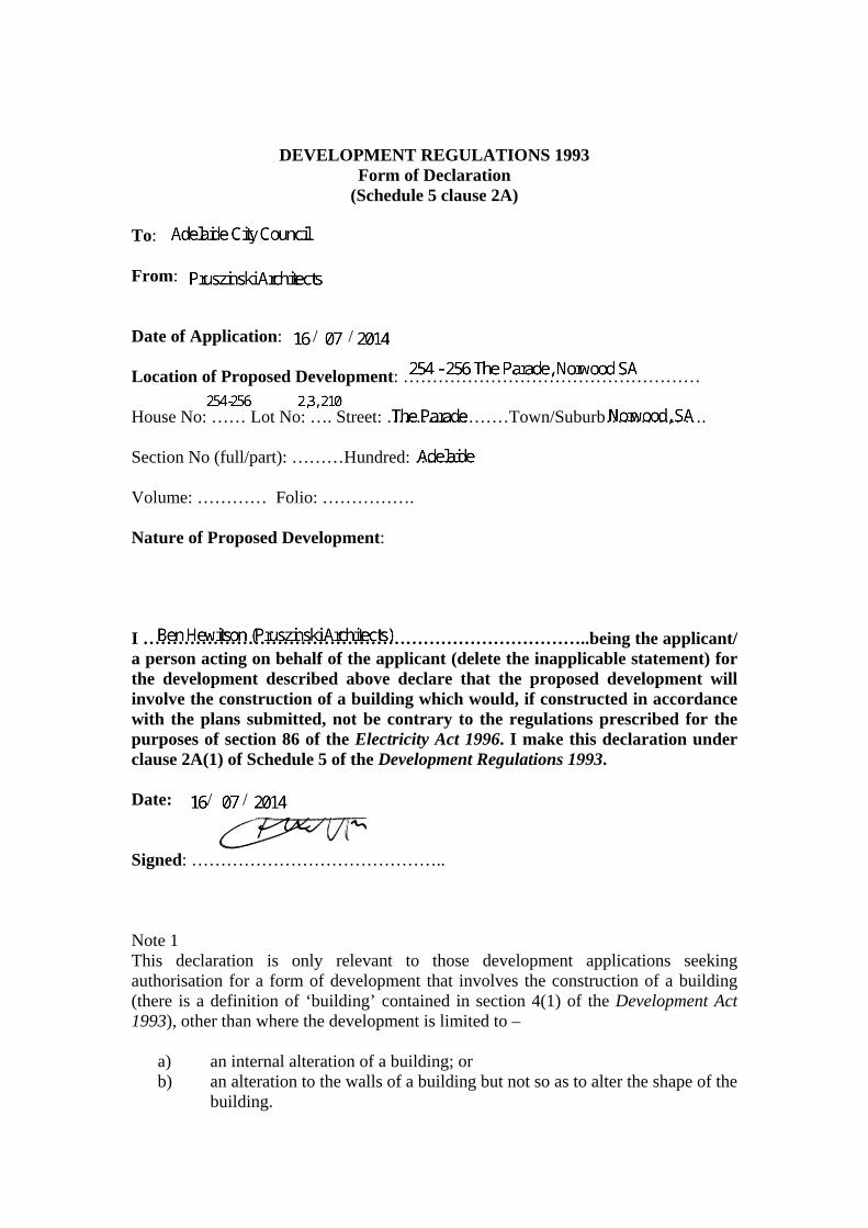
DEVELOPMENT REGULATIONS 1993 Form of Declaration
(Schedule 5 clause 2A) To: From: Date of Application: / / Location of Proposed Development: …………………………………………… House No: …… Lot No: …. Street: …………………Town/Suburb…………. …. Section No (full/part): ………Hundred: …….. Volume: ………… Folio: ……………. Nature of Proposed Development: I …………………………………………………………………..being the applicant/ a person acting on behalf of the applicant (delete the inapplicable statement) for the development described above declare that the proposed development will involve the construction of a building which would, if constructed in accordance with the plans submitted, not be contrary to the regulations prescribed for the purposes of section 86 of the Electricity Act 1996. I make this declaration under clause 2A(1) of Schedule 5 of the Development Regulations 1993. Date: / / Signed: …………………………………….. Note 1 This declaration is only relevant to those development applications seeking authorisation for a form of development that involves the construction of a building (there is a definition of ‘building’ contained in section 4(1) of the Development Act 1993), other than where the development is limited to –
a) an internal alteration of a building; or b) an alteration to the walls of a building but not so as to alter the shape of the
building.
ben
Text Box
254 - 256 The Parade, Norwood SA
ben
Text Box
254-256
ben
Text Box
The Parade
ben
Text Box
Norwood, SA
ben
Text Box
16 07 2014
ben
Text Box
16 07 2014
ben
Text Box
2,3, 210
ben
Text Box
Adelaide
ben
Text Box
Adelaide City Council
ben
Text Box
Pruszinski Architects
ben
Text Box
Ben Hewitson (Pruszinski Architects)
ben
Line
ben
Line
ben
Signature (BH)

Note 2 The requirements of section 86 of the Electricity Act 1996 do not apply in relation to:
a) a fence that is less than 2.0 m in height; or b) a service line installed specifically to supply electricity to the building or
structure by the operator of the transmission or distribution network from which the electricity is being supplied.
Note 3 Section 86 of the Electricity Act 1996 refers to the erection of buildings in proximity to powerlines. The regulations under this Act prescribe minimum safe clearance distances that must be complied with. Note 4 The majority of applications will not have any powerline issues, as normal residential setbacks often cause the building to comply with the prescribed powerline clearance distances. Buildings/renovations located far away from powerlines, for example towards the back of properties, will usually also comply. Particular care needs to be taken where high voltage powerlines exist; where the development:
• is on a major road; • commercial/industrial in nature; or • built to the property boundary.
Note 5 Information brochures ‘Powerline Clearance Declaration Guide’ and ‘Building Safely Near Powerlines’ have been prepared by the Technical Regulator to assist applicants and other interested persons. Copies of these brochures are available from council and the Office of the Technical Regulator. The brochures and other relevant information can also be found at www.technicalregulator.sa.gov.au Note 6 In cases where applicants have obtained a written approval from the Technical Regulator to build the development specified above in its current form within the prescribed clearance distances, the applicant is able to sign the form. PLN/06/0024