Agenda Item 12 Frequently Asked Questions A California...
7
Delta Stewardship Council 980 Ninth St., Suite 1500, Sacramento, CA 95814 www.deltacouncil.ca.gov Frequently Asked Questions A California State Agency Delta Levees Investment Strategy 1. What is the Delta Levees Investment Strategy? The Delta Reform Act of 2009 requires the Delta Stewardship Council to lead a multi-agency effort to establish priorities for State investments in the Delta levee systems. The Delta Levees Investment Strategy will identify State funding priorities and provide direction on a comprehensive investment strategy for the Delta levees—based on the best available data, research, local knowledge, and lessons learned from other State and local programs and planning efforts. In developing the strategy, the Council is using a comprehensive, risk-based methodology that considers the Delta assets protected by levees, threats and hazards (including high water and seismic hazards), and the consequences of flooding (damages). The Council is collaborating with State and Federal agencies, local reclamation districts, Delta landowners, and many other involved stakeholders to prepare the Delta Levees Investment Strategy. 2. Why is an investment strategy needed? Since the 1970s, the State has committed more than $700 million to operate, maintain, and improve Delta levees and reduce risks in the Delta. The needs for State flood management funding, however, continue to exceed the available resources and federal funding is decreasing. The State needs a long-term strategy to guide future investments and prioritize funding. 3. How is the Delta Levees Investment Strategy different from past projects? The Delta Levees Investment Strategy builds on and updates previous levee planning work. The risk-based approach considers the full range of diverse assets that are protected by Delta levees, including lives, property, water supply, and habitat, while also considering the unique features of the Delta region. A risk-based approach considers both the probability of flooding (the likelihood that floods or earthquakes could cause levee failures) and the consequences of flooding, such as lives lost, property damage, flooded habitat, and flooding of islands that protect water supply. This approach results in a more complete understanding of the value of Delta levees than from previous studies. 4. What are the expected project outcomes? This project will result in recommendations for prioritizing State investments to address those islands and tracts with the highest risk. A final report will also identify potential types of investments that best address reducing risk to State interests. The project includes a computer- based tool that is used to inform decision-makers regarding risk in the Delta and can be used to evaluate risk reduction alternatives and plan for future investments. The Delta Stewardship Council will use the strategy to update the Delta Plan’s regulatory policies and performance Agenda Item 12 Attachment 1
-
Upload
duongduong -
Category
Documents
-
view
212 -
download
0
Transcript of Agenda Item 12 Frequently Asked Questions A California...
Delta Stewardship Council 980 Ninth St., Suite 1500, Sacramento, CA 95814 www.deltacouncil.ca.gov
Frequently
Asked
Questions A California State Agency
Delta Levees Investment Strategy
1. What is the Delta Levees Investment Strategy?
The Delta Reform Act of 2009 requires the Delta Stewardship Council to lead a multi-agency effort
to establish priorities for State investments in the Delta levee systems. The Delta Levees Investment
Strategy will identify State funding priorities and provide direction on a comprehensive investment
strategy for the Delta levees—based on the best available data, research, local knowledge, and
lessons learned from other State and local programs and planning efforts. In developing the
strategy, the Council is using a comprehensive, risk-based methodology that considers the Delta
assets protected by levees, threats and hazards (including high water and seismic hazards), and
the consequences of flooding (damages). The Council is collaborating with State and Federal
agencies, local reclamation districts, Delta landowners, and many other involved stakeholders to
prepare the Delta Levees Investment Strategy.
2. Why is an investment strategy needed?
Since the 1970s, the State has committed more than $700 million to operate, maintain, and
improve Delta levees and reduce risks in the Delta. The needs for State flood management
funding, however, continue to exceed the available resources and federal funding is decreasing.
The State needs a long-term strategy to guide future investments and prioritize funding.
3. How is the Delta Levees Investment Strategy different from past projects?
The Delta Levees Investment Strategy builds on and updates previous levee planning work. The
risk-based approach considers the full range of diverse assets that are protected by Delta
levees, including lives, property, water supply, and habitat, while also considering the unique
features of the Delta region. A risk-based approach considers both the probability of flooding
(the likelihood that floods or earthquakes could cause levee failures) and the consequences of
flooding, such as lives lost, property damage, flooded habitat, and flooding of islands that
protect water supply. This approach results in a more complete understanding of the value of
Delta levees than from previous studies.
4. What are the expected project outcomes?
This project will result in recommendations for prioritizing State investments to address those
islands and tracts with the highest risk. A final report will also identify potential types of
investments that best address reducing risk to State interests. The project includes a computer-
based tool that is used to inform decision-makers regarding risk in the Delta and can be used to
evaluate risk reduction alternatives and plan for future investments. The Delta Stewardship
Council will use the strategy to update the Delta Plan’s regulatory policies and performance
Agenda Item 12 Attachment 1
Frequently Asked Questions – Delta Levees Investment Strategy
Delta Stewardship Council 980 Ninth St., Suite 1500, Sacramento, CA 95814 www.deltacouncil.ca.gov
measures for reducing risk in the Delta. The Council also will report to the Legislature on the
project’s findings and recommendations.
5. What is the project schedule?
The project began in July 2014 and the report to the California Legislature will be submitted in
the spring of 2017. A more detailed schedule is available on the project web page
(www.deltacouncil.ca.gov/delta-levees-investment-strategy).
6. How does this project relate to flood management work by the Central Valley Flood
Protection Board (CVFPB) and the Department of Water Resources (DWR)?
As part of the Central Valley Flood Protection Plan, CVFPB and DWR are supporting six regional
flood management plans, which present local agency perspectives of flood management and a
prioritized list of projects that need to be implemented to reduce flood risks in each region. Two
of these regions (Lower Sacramento River/Delta North and Lower San Joaquin River/Delta
South) overlap with the Delta and include the urban areas of Sacramento and Stockton. Also
through DWR, the State provides funding for a Delta levees program for the rural parts of the
Delta, which primarily involves State grants to local reclamation districts for levee maintenance
and improvement. The Council is coordinating with the CVFPB and DWR so that the Delta
Levees Investment Strategy will describe an overall, coordinated strategy and priorities for levee
investments in both the urban and rural parts of the Delta, as well as Suisun Marsh.
7. How can the public get involved?
The Council is committed to a robust, open process to develop the Delta Levees Investment
Strategy. As of July 2016, the project team has held 6 community meetings, 2 public scoping
meetings, and more than 25 workshops and briefings with agencies and stakeholders to identify
the best available information and better understand their priorities. The Delta Levees
Investment Strategy website (http://deltacouncil.ca.gov/delta-levees-investment-strategy) also
provides updated project news, information, meetings, and ways to get involved.
Information and Analysis
8. How will the Council set priorities?
The Council is using a risk analysis approach to identify where the risks to lives, property, and
State interests are the greatest. The Council will consider the risk analysis results, along with
other information such as current legislative requirements, past expenditures, and anticipated
costs for risk reduction actions in order to identify priorities for levee investment.
Agenda Item 12 Attachment 1
Frequently Asked Questions – Delta Levees Investment Strategy
Delta Stewardship Council 980 Ninth St., Suite 1500, Sacramento, CA 95814 www.deltacouncil.ca.gov
9. What risks are being evaluated?
The Council is considering flood risk to lives, property, the coequal goals of water supply and
ecosystem restoration, and flood risk to the unique values of Delta as an evolving place, such as
legacy towns, prime agricultural land, and the local public road network. In March 2015, the
Council provided direction on the State interests that guide levee investment priorities.
Evaluating risks in the Delta and Suisun Marsh includes consideration of the probability of
flooding islands and tracts (overtopping or breaching failure of levees from riverine flooding or
earthquakes) and the consequences (damages) that would occur from various depths of
flooding.
10. How is the Council evaluating the effects on the regional and statewide economy?
The risk to property is based on the direct consequences of flooding, i.e., the costs of physical
damage to structures, infrastructure, and crops. This approach is consistent with guidance from
the National Research Council and the methodologies used by the U.S. Army Corps of Engineers
(USACE) and the Federal Emergency Management Agency. The indirect effects, such as
disruption of business activity, employment, transportation, and water supply, and the resulting
economic effects, are highly dependent on the timing and length of disruption and very
uncertain or speculative. The Delta Levees Investment Strategy will be based only on the direct
consequences of flooding. Future analyses may add details about potential indirect effects.
11. How is the interconnected nature of Delta levees being considered?
The risk evaluation is considering all of the major benefits of Delta levees for people, property,
water supply, habitat, legacy towns, agriculture, and transportation that would be affected by
levee failures. The analysis identifies where risks to these systems are greatest. The potential for
multiple, simultaneous island failures is also being evaluated. Directing State resources to the
areas of greatest risk will reduce overall risk in the Delta in a cost-effective manner.
12. How is the strategy considering sea level rise?
The Delta Levees Investment Strategy is considering sea level rise in the Delta in two future
timeframes, 2030 and 2050. To account for uncertainties about potential sea level rise, two
scenarios are considered for each timeframe, a nominal forecast and a high forecast. These
forecasts are based on current State planning policy, which is informed by the 2012 National
Research Council report on potential sea level rise. In 2015, the California Natural Resources
Agency adopted this guidance as the best available science.
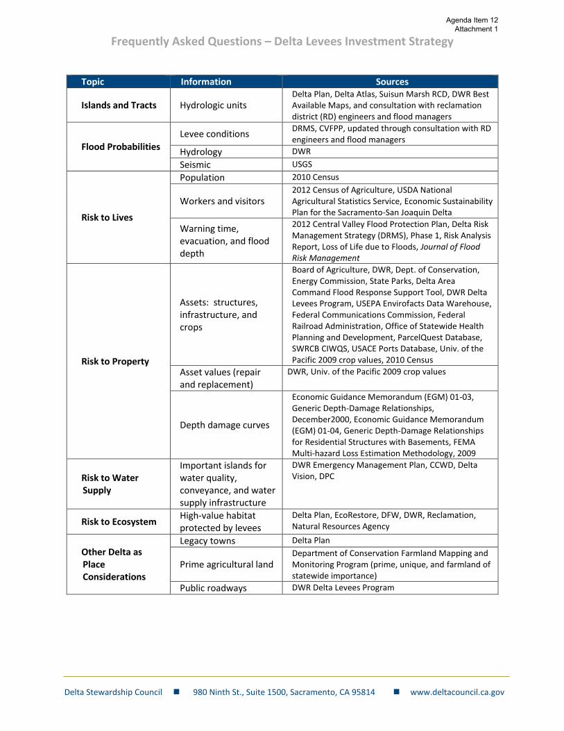
13. What information is being used to evaluate risks?
The Council is relying on the best available information from previous studies and evaluations.
No additional levee evaluations are being performed. The project team has met with
knowledgeable local engineers and stakeholders to update information where possible. The
Council report to the Legislature may identify where additional research and assessments are
needed. The following table outlines the major sources of information.
Agenda Item 12 Attachment 1
Frequently Asked Questions – Delta Levees Investment Strategy
Delta Stewardship Council 980 Ninth St., Suite 1500, Sacramento, CA 95814 www.deltacouncil.ca.gov
Topic Information Sources
Islands and Tracts Hydrologic units Delta Plan, Delta Atlas, Suisun Marsh RCD, DWR Best Available Maps, and consultation with reclamation district (RD) engineers and flood managers
Flood Probabilities
Levee conditions DRMS, CVFPP, updated through consultation with RD engineers and flood managers
Hydrology DWR
Seismic USGS
Risk to Lives
Population 2010 Census
Workers and visitors 2012 Census of Agriculture, USDA National Agricultural Statistics Service, Economic Sustainability Plan for the Sacramento-San Joaquin Delta
Warning time, evacuation, and flood depth
2012 Central Valley Flood Protection Plan, Delta Risk Management Strategy (DRMS), Phase 1, Risk Analysis Report, Loss of Life due to Floods, Journal of Flood Risk Management
Risk to Property
Assets: structures, infrastructure, and crops
Board of Agriculture, DWR, Dept. of Conservation, Energy Commission, State Parks, Delta Area Command Flood Response Support Tool, DWR Delta Levees Program, USEPA Envirofacts Data Warehouse, Federal Communications Commission, Federal Railroad Administration, Office of Statewide Health Planning and Development, ParcelQuest Database, SWRCB CIWQS, USACE Ports Database, Univ. of the Pacific 2009 crop values, 2010 Census
Asset values (repair and replacement)
DWR, Univ. of the Pacific 2009 crop values
Depth damage curves
Economic Guidance Memorandum (EGM) 01-03, Generic Depth-Damage Relationships, December2000, Economic Guidance Memorandum (EGM) 01-04, Generic Depth-Damage Relationships for Residential Structures with Basements, FEMA Multi-hazard Loss Estimation Methodology, 2009
Risk to Water Supply
Important islands for water quality, conveyance, and water supply infrastructure
DWR Emergency Management Plan, CCWD, Delta Vision, DPC
Risk to Ecosystem High-value habitat protected by levees
Delta Plan, EcoRestore, DFW, DWR, Reclamation, Natural Resources Agency
Other Delta as Place Considerations
Legacy towns Delta Plan
Prime agricultural land Department of Conservation Farmland Mapping and Monitoring Program (prime, unique, and farmland of statewide importance)
Public roadways DWR Delta Levees Program
Agenda Item 12 Attachment 1
Frequently Asked Questions – Delta Levees Investment Strategy
Delta Stewardship Council 980 Ninth St., Suite 1500, Sacramento, CA 95814 www.deltacouncil.ca.gov
14. How is the Council using older information that may be out of date, such as the Delta Risk
Management Strategy (DRMS)?
Information and understanding in the Delta is constantly evolving. The risk analysis and the
decision support tool are designed to be updated with new information as it becomes available.
The project team reviewed and evaluated all current data, including data obtained from DRMS,
to confirm that the data represent the best available and most current information. Regarding
the DRMS data, the CALFED Science Program Independent Review Panel review of the revised
DRMS Phase I report concluded that the report is “…acceptable for use as a tool for informing
policymakers and others regarding potential resource allocations and strategies to address risk
in the Delta region.” The Independent Review Panel for the Delta Levees Investment Strategy
concluded, “The overall methodology of using existing data, identifying important metrics,
aggregating results, and making comparisons across islands is conceptually sound.”
Costs and Funding
15. How is the Delta Levees Investment Strategy project funded?
The funding for the Delta Levees Investment Strategy is provided by DWR with funds from
Proposition 1E.
16. How will future risk-reduction measures be funded?
Future funding for levee improvements and other risk-reduction strategies will likely come from
various sources, including the State of California and the landowners, businesses, and water
users who benefit from the levees. The USACE is evaluating the feasibility of providing funds to
improve project levees in urban areas and some other areas. The 2013 Delta Plan supports
alternative flood management funding mechanisms that incorporate local participation by all
beneficiaries of flood risk management. The Delta Protection Commission is currently studying
the feasibility of a Delta levees assessment district, including identification of potential
beneficiaries of Delta levees and alternate funding structures.
17. Will there be changes to existing programs to fund levee improvements and maintenance?
The Legislature directed the Council to identify priorities for State investment to reduce risk to
lives, property, and State interests, including determining priorities for levee improvement and
maintenance. Current State funding for levees is managed by DWR, with oversight and review
by the Council, the CVFPB, and California Water Commission. These programs have provided
substantial funds for Delta levees over the past 30 years and the frequency of levee failures has
declined. With a better understanding of overall risk in the Delta, it is possible the Legislature
could alter levee programs and emergency response planning to further reduce risk to State
interests.
Agenda Item 12 Attachment 1
Frequently Asked Questions – Delta Levees Investment Strategy
Delta Stewardship Council 980 Ninth St., Suite 1500, Sacramento, CA 95814 www.deltacouncil.ca.gov
Background on Delta Levees and Flood Risks
18. What is the Delta?
The Sacramento-San Joaquin Delta, formed by the confluence of the Sacramento and San
Joaquin Rivers, is the largest estuary on the West Coast. The Delta, along with the Suisun Marsh,
is a regional, State, and national treasure that is home to more than 515,000 people and 750
animal and plant species, supplies drinking water to 25 million Californians and irrigation water
for the majority of California’s agricultural industry, and attracts 12 million recreational visitors
annually.
19. Why does the Delta need levees?
Early settlers built an intricate levee system in the Delta’s marshes to create dry “islands”
suitable for farming. Today, these levees protect land-based assets, including residential and
commercial structures, agricultural land, gas and water supply pipelines, roads, bridges,
railroads, and wildlife habitats. They also affect water-side assets, including fresh water flows,
salinity management, aquatic habitat, wildlife, migration corridors, and shipping channels.
20. What threatens the Delta levees?
The Delta levees are vulnerable to damage caused by floods, wave action, seepage, subsidence,
earthquakes, sea-level rise, and some human and wildlife activities.
21. What can be done to reduce risks in the Delta?
A variety of actions can reduce risk in the Delta, such as upgrading and improving current
levees, managing and improving channels and floodplains that carry flood waters, elevating
houses to protect against floods, and improving emergency response preparation and
evacuation planning. Additional risk can be avoided by careful land use planning, as required by
the 2013 Delta Plan.
22. Who is responsible for the levees?
Federal, State, regional, and local agencies each have a role in planning, overseeing, and
implementing levee maintenance and improvements. There are approximately 1,100 miles of
levees in the Delta. About one-third of Delta levees (generally in the lower portions of the
Sacramento and San Joaquin rivers) are called “project” levees. These levees are part of the
State Plan of Flood Control, which is managed and funded by federal, State, and local agencies.
The remaining levees are called “non-project” levees, which are owned and managed by local
reclamation districts with funding support from the State. In Suisun Marsh, funds to maintain or
improve levees are usually provided by the marsh’s duck hunting clubs and other landowners,
without State assistance.
Agenda Item 12 Attachment 1
Frequently Asked Questions – Delta Levees Investment Strategy
Delta Stewardship Council 980 Ninth St., Suite 1500, Sacramento, CA 95814 www.deltacouncil.ca.gov
23. What are PL-84-99 and Bulletin 192-82?
Public Law 84-99 authorizes the USACE to undertake flood management activities including
disaster preparedness, response activities, and rehabilitation. Under this law, USACE established
levee maintenance, design, and inspection standards for eligibility for federal post-disaster
levee repair funds. Managers of the “project” levees and some non-project levees in the Delta
seek to comply with these standards so that they maintain eligibility. Bulletin 192-82 was
published in 1982 by DWR to establish urban and agricultural levee design standards for the
Delta. These standards guide State funding for “non-project” levees in the Delta. The levee
design standards under PL 84-99 and Bulletin 192-82 are similar, but not identical.
24. Who benefits from the levees?
The levees reduce risk and provide benefits to residents, landowners, and businesses on the
islands; owners and users of energy and transportation infrastructure (private companies, the
State, and local government); water supply agencies and their customers; and the public
(recreation and the environment).
25. What would happen if the Delta levees fail?
A levee failure (or multiple levee failures) and the resulting flooding could cause injury to people
or loss of life. Levee failures could also damage property, highways, and energy utilities; disrupt
water supplies and water supply systems; harm the Delta ecosystem; and damage the Delta as a
place, all of which could harm the regional and statewide economy and environment.
Agenda Item 12 Attachment 1