AGENDA FOR THE Canterbury Bankstown Local Planning Panel ... · representatives from Council, the...
68
AGENDA FOR THE Canterbury Bankstown Local Planning Panel MEETING 13 June 2018 - 6.00pm Location: Council Chambers Cnr Chapel Road and the Mall, Bankstown
Transcript of AGENDA FOR THE Canterbury Bankstown Local Planning Panel ... · representatives from Council, the...
AGENDA FOR THECanterbury Bankstown Local Planning Panel MEETING
13 June 2018 - 6.00pm
Location:
Council Chambers Cnr Chapel Road and the Mall, Bankstown

ORDER OF BUSINESS
BANKSTOWN WARD
1 Planning Proposal: 998 Punchbowl Road (1499 Canterbury Road), Punchbowl .................................................................................................................... 3
ROSELANDS WARD
2 Planning Proposal: 677-687 Canterbury Road and 46-48 Drummond Street, Belmore .......................................................................................................... 13
3 Planning Proposal: 754-774 Canterbury Road, Belmore .......................................... 27
4 Planning Proposal: 1112-1186 Canterbury Road, Roselands ................................... 37
5 Planning Proposal: 1375 Canterbury Road, Punchbowl ........................................... 47
6 Planning Proposal: 642-644 Canterbury Road, 650-658 Canterbury Road, 1-3 Platts Avenue and 2, 2A-2D Liberty Street, Belmore ......................................... 57
Canterbury Bankstown Local Planning Panel - 13 June 2018
Canterbury Bankstown Local Planning Panel Meeting held on 13 June 2018 Page 3
ITEM 1 Planning Proposal: 998 Punchbowl Road (1499 Canterbury Road), Punchbowl
AUTHOR Planning
PURPOSE AND BACKGROUND
The former Canterbury City Council was in receipt of applications to prepare planning proposals along Canterbury Road, and had also initiated its own planning proposals in the corridor prior to amalgamation with the former Bankstown City Council. The planning proposals have not been progressed due to a Council resolution of 22 November 2016 that deferred progress on planning proposals in the corridor until the Canterbury Road Review is finalised, and a clear policy direction for Canterbury Road is endorsed by Council. This included an applicant initiated proposal for 998 Punchbowl Road (1499 Canterbury Road), Punchbowl.
A report on the exhibition of the Review was considered by Council on 22 May 2018 seeking Council’s in-principle support for the Review and to seek endorsement of the next steps. It is now appropriate to make a decision on the outstanding planning proposals, including the applicant initiated planning proposal for this site.
ISSUE It is recommended that the applicant be required to submit an amended planning proposal for the subject land for the following reasons: • The land is within the Punchbowl Road Junction which is proposed under the
Canterbury Road Review to be rezoned to a B2 Local Centre or similar permitting shop top housing.
• A submission from the applicant to the Canterbury Road Review requested the B2 Local Centre zoning. However, this is inconsistent with the planning proposal which proposes an R4 High Density Residential zoning and the planning proposal would need to be amended to proceed with a B2 Local Centre zoning.
• The proposed eight storeys is inconsistent with the six storeys outlined in the Canterbury Road Review vision.
• The proposed FSR of 2.8:1 is inconsistent with the Canterbury Road Review vision of 2.5:1 (1.9:1 residential plus 0.6:1 non-residential).
• Any future planning proposal would need to integrate land required by Roads and Maritime Services for road widening at the intersection of Punchbowl and Canterbury Roads.

Canterbury Bankstown Local Planning Panel Meeting held on 13 June 2018 Page 4
RECOMMENDATION That -
1. The applicant be requested to submit an amended planning proposal demonstrating consistency with the Canterbury Road Review and planning proposal reflective of that supported by Council for Club Punchbowl.
2. An updated traffic impact assessment based on the traffic and transport study completed for the Canterbury Road Review be undertaken.
3. If an amended planning proposal is not received, Council not proceed with the current proposal, and consider appropriate controls for the site as part of further work for the Punchbowl Road Junction.
4. Any future changes to the planning provisions of the site incorporate road widening requirements of Roads and Maritime Services.
5. Council write to the Department of Planning and Environment advising of Council’s decision and seek an amendment to the planning proposal subject to any further analysis and as outlined in this report.
ATTACHMENTS Nil
Canterbury Bankstown Local Planning Panel Meeting held on 13 June 2018 Page 5
POLICY IMPACT There will be no policy impact as the recommendation is in accordance to the policy direction for Canterbury Road adopted by Council at its meeting of 22 May 2018.
FINANCIAL IMPACT
At this stage, progressing with the staff recommendation in relation to the planning proposal would have no financial implications for Council.
COMMUNITY IMPACT The Canterbury Road Review was undertaken partly as a result of strong community feedback in relation to the quantity and design quality of housing developments in the corridor. The Review recommendations are focussed on improved amenity through increasing open space, pedestrian connections, public domain improvements, building design and other outcomes. The staff recommendation in relation to the planning proposal is consistent with the Review and proceeding with the recommendation would result in a positive community impact.
Canterbury Bankstown Local Planning Panel Meeting held on 13 June 2018 Page 6
DETAILED INFORMATION Canterbury Road Review The Canterbury Local Environmental Plan 2012 (LEP), adopted by the former Canterbury City Council on 1 January 2013, established the current planning framework for the Canterbury Road Corridor. The Canterbury Residential Development Strategy (RDS), adopted by the former Canterbury City Council in 2014, was prepared to ensure that the LEP comprises appropriate zonings and development controls to guide and cater for housing growth, consistent with the State government housing agenda through to 2031. Notwithstanding the 2012 LEP and the 2014 RDS, the scale and quantum of development that has been approved and developed is inconsistent with the strategic direction for Canterbury Road and led to development that is of a bulk and size that does not balance amenity and solar access or provide best practice in relation to urban renewal along busy roads. In this regard, the Canterbury Road Review was prompted by: • Issues and impacts associated with additional development and resulting dwelling
yield from approved developments that exceed the height and floor space ratio (FSR) controls that were not contemplated when the LEP was made or by the RDS.
• The lack of an FSR control has resulted in large bulky overly-dense built forms that negatively impact on the corridor amenity and the quality of life for residents in proximity to these buildings.
• A comprehensive submission from Roads and Maritime Service (RMS) expressing concerns about cumulative traffic impacts from the proposed rezoning of land to B5 Business Development under the LEP for residential uses with increased yields in Canterbury Road.
• A large number of privately led planning proposals that seek to increase the development potential of numerous development sites with site specific amendments to the LEP.
• The release of government strategies and infrastructure projects such as the draft South District Plan, the draft Sydenham to Bankstown Urban Renewal Strategy and WestConnex.
• The relatively low level of development occurring in the R3 Medium Density Residential and R4 High Density Residential zones under the LEP.
In response to the above, Council resolved on 26 July 2016 and later on 23 August 2016 to: • Commence a strategic review of the existing policy framework for the Corridor. • Adopt a methodology to guide a strategic review of the Corridor. • Endorse the establishment of an agency Steering Committee comprising
representatives from Council, the Department of Planning and Environment (DP&E), RMS, Transport for NSW (TfNSW) and Greater Sydney Commission (GSC).
The outcome of the Canterbury Road Review includes a standalone report, three specialist consultant studies prepared to inform the Review and 15 recommendations endorsed by the Steering Committee in relation to land use, built form and urban amenity and infrastructure.

Canterbury Bankstown Local Planning Panel Meeting held on 13 June 2018 Page 7
The consultant studies are in relation to specific issues as follows: • Urban Design Study – Hill Thalis Architecture + Urban Projects Pty Ltd (Hill Thalis). • Economic Analysis – SGS Economics and Planning (SGS). • Transport and Traffic Study – GHD. A copy of the Canterbury Road Review has been provided to Panel members under separate cover and is also available on Council’s website, including technical studies. It is intended that the Review, including recommendations, will be used by a range of Council and other stakeholders, including the NSW State agencies, to: • Guide changes to land use planning and built form controls along the corridor. • Provide the evidence to support informed decisions and advocacy to government in
relation to current and future growth and infrastructure strategies. • Establish a long-term plan for investment in and enhancement of urban amenities,
open space, active transport, street design and other infrastructure in the Canterbury Road Corridor and surrounding land.
• Support requests for government support and funding to aid in the delivery of some of the recommendations, for example the GSC’s Metropolitan Greenspace Program.
• Inform decisions on planning proposals related to the corridor and surrounding land. The recommendations of the Review detailed in the report were endorsed for public exhibition at the final agency Steering Committee on 30 June 2017. A letter received by Council on 3 July 2017 from the RMS further confirmed their endorsement of the Review for exhibition. Council also resolved to place the Review on exhibition on 25 July 2017 and that the results of the exhibition be reported back to Council. The results of exhibition of the Review were reported back to Council at its meeting on 22 May 2018. A copy of that report has been provided under separate cover to Panel members but is also available for viewing on Council’s website. Outstanding planning proposals in Canterbury Road In recent years a number of applicant initiated planning proposals along Canterbury Road have been lodged with Council, and some have been initiated by the former Canterbury City Council. There are six applicant initiated planning proposals and a further three Council initiated planning proposals which have not progressed due to an unresolved objection by the RMS. Council also resolved on 22 November 2016 to defer a decision on those planning proposals until the Canterbury Road Review was finalised and a clear policy direction endorsed.

Canterbury Bankstown Local Planning Panel Meeting held on 13 June 2018 Page 8
The status and address of each outstanding planning proposal is outlined in Table 1 below.
Status Properties Total
Applicant initiated planning proposals received but not submitted to DP&E for Gateway Determination
• 251-267 Canterbury Road, Canterbury
• 677-687 Canterbury Road and 46-48 Drummond Street, Belmore
• 754-774 Canterbury Road, Belmore
3
Applicant initiated planning proposal submitted for Gateway Determination not in form of latest Council resolution and not determined by DP&E
• 1499 Canterbury Road (998 Punchbowl Road), Punchbowl
1
Applicant initiated planning proposals with Gateway Determination – Conditional approvals
• 538-546 Canterbury Rd Campsie and 570-580 Canterbury Road, Belmore
• 642-644 Canterbury Road, 650-658 Canterbury Road, 1-3 Platts Avenue and 2A-2D Liberty Street, Belmore
2
Sites part of the exhibited RDS planning proposal that did not proceed due to unresolved RMS objection
• 403-411 Canterbury Rd, 1 Una St & block bounded by Canterbury Rd, Duke St, Perry St and Stanley St, Campsie
• 1112-1186 Canterbury Rd, Roselands
• 1375 Canterbury Road, Punchbowl
3
Total 9
Table 1: Status of Planning Proposals in Canterbury Road Applicant initiated planning proposals All of the applicant initiated planning proposals seek to permit development that would exceed the agreed vision for the Canterbury Road Corridor, including the planning controls, as proposed by the Review. Four have no formal status and would require Gateway approvals to proceed, including the planning proposal for the subject land. Gateway approval is granted by the Greater Sydney Commission by deciding that the planning proposal can proceed (with or without variation). If determined to proceed, the planning proposal may then be subject to other matters including further studies, public consultation, public hearings, agency consultation and time frames. Without Gateway approval, a planning proposal cannot proceed to exhibition or finalisation. Council initiated planning proposals with an unresolved objection by the RMS Three sites that the former Canterbury City Council resolved to rezone (and/or increase the height controls) as part of a planning proposal were intended to implement its RDS. The proposed changes to planning controls for these sites were exhibited as part of the broader planning proposal for the RDS, but were removed due to an unresolved objection from the RMS relating to traffic impact. The sites that remained in the RDS planning proposal were eventually made (gazetted). Consequently, the proposals for the remaining three sites have no formal status and would require a new Council resolution and planning proposal if they were to be progressed.
Canterbury Bankstown Local Planning Panel Meeting held on 13 June 2018 Page 9
Review of planning proposals in relation to Canterbury Road Review Recommendation 15 of the Review states that Council will assess the above outstanding planning proposals for consistency with the Review. Recommendation 15 is outlined in full on page 37 of the Canterbury Road Review document. A review of each planning proposal with a recommendation in relation to the consistency of the proposals with the Review has been undertaken. The advice provided by the Panel in relation to each planning proposal will inform the report back to Council for a decision as to whether or not to proceed.

Canterbury Bankstown Local Planning Panel Meeting held on 13 June 2018 Page 10
Planning Proposal: 998 Punchbowl Road (1499 Canterbury Road), Punchbowl. Overview The location of the site is shown in the Canterbury Local Environmental Plan 2012 (LEP) map in the table provided below (bound by yellow). The existing planning provisions for the site under the LEP, the changes proposed under the Canterbury Road Review and details of the applicant initiated planning proposal are also provided.
Canterbury
Local
Environmental
Plan 2012
Current Planning Controls
• R3 Medium Density Residential
• Maximum Height 8.5m (2 storeys)
• FSR 0.5:1
Planning
Proposal
• Rezone to R4 High Density Residential
• Increase maximum building height to 25m (8 storeys)
• Increase maximum FSR to 2.8:1
Canterbury
Road Review
Proposed Planning Controls in Review
• Punchbowl Road Junction
• Rezone to B2 Local Centre or similar zoning permitting shop top housing
• 4-6 Storeys
• FSR 2.5:1 (Max. 1.9:1 residential and 0.6:1 commercial)
Background The subject land was originally the subject of a submission to the RDS which sought the rezoning of the site to R4 High Density Residential, a maximum FSR of 2.5:1 and a maximum building height of 18m (five storeys). The RDS recommended no change to the existing planning controls (R3 Medium Density Residential Zone, FSR of 0.5:1 and a maximum building height of 8.5m/two storeys) however Council resolved to rezone the site to R4 High Density Residential with a FSR of 1.8:1 and a maximum building height of 15m.
Canterbury Bankstown Local Planning Panel Meeting held on 13 June 2018 Page 11
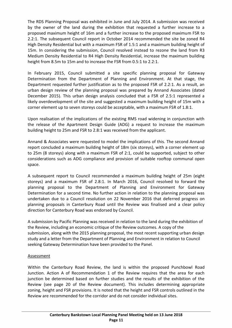
The RDS Planning Proposal was exhibited in June and July 2014. A submission was received by the owner of the land during the exhibition that requested a further increase to a proposed maximum height of 16m and a further increase to the proposed maximum FSR to 2.2:1. The subsequent Council report in October 2014 recommended the site be zoned R4 High Density Residential but with a maximum FSR of 1.5:1 and a maximum building height of 15m. In considering the submission, Council resolved instead to rezone the land from R3 Medium Density Residential to R4 High Density Residential, increase the maximum building height from 8.5m to 15m and to increase the FSR from 0.5:1 to 2.2:1. In February 2015, Council submitted a site specific planning proposal for Gateway Determination from the Department of Planning and Environment. At that stage, the Department requested further justification as to the proposed FSR of 2.2:1. As a result, an urban design review of the planning proposal was prepared by Annand Associates (dated December 2015). This urban design analysis concluded that a FSR of 2.5:1 represented a likely overdevelopment of the site and suggested a maximum building height of 15m with a corner element up to seven storeys could be acceptable, with a maximum FSR of 1.8:1. Upon realisation of the implications of the existing RMS road widening in conjunction with the release of the Apartment Design Guide (ADG) a request to increase the maximum building height to 25m and FSR to 2.8:1 was received from the applicant. Annand & Associates were requested to model the implications of this. The second Annand report concluded a maximum building height of 18m (six storeys), with a corner element up to 25m (8 storeys) along with a maximum FSR of 2:1, could be supported, subject to other considerations such as ADG compliance and provision of suitable rooftop communal open space. A subsequent report to Council recommended a maximum building height of 25m (eight storeys) and a maximum FSR of 2.8:1. In March 2016, Council resolved to forward the planning proposal to the Department of Planning and Environment for Gateway Determination for a second time. No further action in relation to the planning proposal was undertaken due to a Council resolution on 22 November 2016 that deferred progress on planning proposals in Canterbury Road until the Review was finalised and a clear policy direction for Canterbury Road was endorsed by Council. A submission by Pacific Planning was received in relation to the land during the exhibition of the Review, including an economic critique of the Review outcomes. A copy of the submission, along with the 2015 planning proposal, the most recent supporting urban design study and a letter from the Department of Planning and Environment in relation to Council seeking Gateway Determination have been provided to the Panel. Assessment Within the Canterbury Road Review, the land is within the proposed Punchbowl Road Junction. Action A of Recommendation 1 of the Review requires that the area for each junction be determined based on further studies and the results of the exhibition of the Review (see page 20 of the Review document). This includes determining appropriate zoning, height and FSR provisions. It is noted that the height and FSR controls outlined in the Review are recommended for the corridor and do not consider individual sites.
Canterbury Bankstown Local Planning Panel Meeting held on 13 June 2018 Page 12
A submission received from Pacific Planning during the exhibition of the Review requests a B2 Local Centre zoning which is as per the Review recommendations. However, this is inconsistent with the planning proposal which proposes an R4 High Density Residential zoning. An amended planning proposal would need to be submitted to proceed with a B2 Local Centre zoning. The planning proposal includes an eight storey height limit which is inconsistent with the four to six storeys outlined in the Review vision. The proposed FSR of 2.8:1 is also inconsistent with the Review which provides for an FSR of 2.5:1 (1.9:1 residential plus 0.6:1 non-residential). Further, the proposed FSR control is also inconsistent with the FSR control that is being sought in a planning proposal for Club Punchbowl directly opposite the site on Punchbowl Road (1.8:1) which has a much larger site area. There are some concerns that the site constraints may not allow 2.5:1 and four to six storeys to be achieved because of: • The relatively small size of the subject land; • The amount of land required by RMS for road widening at the intersection; and • The scale of redevelopment proposed considering the largely single storey low density
character of adjoining land along Canterbury and Punchbowl Roads. As a result of the above, it is likely that the height and FSR controls detailed in the Review may also not be achievable and that further urban design work is required to determine an appropriate height and FSR based on site constraints. This could be part of the work to be undertaken for the Punchbowl Road Junction as per Recommendation 1 discussed above or as part of an amended planning proposal. Given the land’s location in the proposed Punchbowl Road Junction, its location opposite Club Punchbowl, and that an amended planning proposal is required to be submitted to request a B2 Local Centre zoning, it is considered that the applicant should be requested to submit an amended planning proposal detailing the proposed zone change and demonstrating consistency with the Review (including height and FSR controls) and the Club Punchbowl site as per Council planning proposal. A detailed traffic impact assessment based on the transport and traffic study undertaken as part of the Review would needed to be submitted as part of any amended planning proposal.

Canterbury Bankstown Local Planning Panel - 13 June 2018
Canterbury Bankstown Local Planning Panel Meeting held on 13 June 2018 Page 13
ITEM 2 Planning Proposal: 677-687 Canterbury Road and 46-48 Drummond Street, Belmore
AUTHOR Planning
PURPOSE AND BACKGROUND
The former Canterbury City Council was in receipt of applications to prepare planning proposals along Canterbury Road, and had also initiated its own planning proposals in the corridor prior to amalgamation with the former Bankstown City Council. The planning proposals have not been progressed due to a Council resolution of 22 November 2016 that deferred progress on planning proposals in the corridor until the Canterbury Road Review is finalised, and a clear policy direction for Canterbury Road is endorsed by Council. This included an applicant initiated proposal for 677-687 Canterbury Road and 46-48 Drummond Street, Belmore.
A report on the exhibition of the Review was considered by Council on 22 May 2018 seeking Council’s in-principle support for the Review and to seek endorsement of the next steps. It is now appropriate to make a decision on the outstanding planning proposals, including this applicant initiated planning proposal for this site.
ISSUE This report recommends that Council proceed with the planning proposal for the following reasons: • A Site Compatibility Certificate (SCC) was issued by the Department of Planning and
Environment under State Environmental Planning Policy (Affordable Rental Housing) 2009 (SEPP) for the site in July 2014 for the construction of a mixed use development comprising three buildings, with ground floor commercial space along Canterbury Road and residential development pursuant to the SEPP. The site is likely to be developed for this purpose if the planning proposal is not progressed.
• Proceeding with a planning proposal that includes potential community benefits via a voluntary planning agreement is considered to be a more desirable outcome than the residential development permitted by the site compatibility certificate that could be utilised by the applicant should the planning proposal not proceed.
• A revised urban design study to ensure consistency with the Review vision can be undertaken prior to Council considering whether or not to refer the planning proposal to the Department of Planning and Environment for Gateway Determination.
• The demand for employment uses in relation to rezoning the B6 Enterprise Corridor land can be further investigated as part of the planning proposal.
• 46 Drummond Street is a small parcel of land that will not substantially assist with increasing the supply of medium density housing in the area and is proposed to be utilised as public open space.
Canterbury Bankstown Local Planning Panel Meeting held on 13 June 2018 Page 14
RECOMMENDATION That -
1. The applicant amend the planning proposal for the site to address the following matters: a. The ability for the site to accommodate employment uses be further investigated
and a change to the zoning to remove employment lands be justified as per the section 9.1 directions and in consideration of the South District Plan.
b. The proposed height and the FSR provisions be consistent with Review. c. The consistency of the planning proposal with the built form intent of the Review
via a revised urban design study and the proposed density be considered in line with it’s out of junction location.
d. Update the traffic impact assessment based on the traffic and transport study completed for the Review.
2. The matter be reported to the Local Planning Panel once an amended planning proposal has been received and assessed.
ATTACHMENTS Nil

Canterbury Bankstown Local Planning Panel Meeting held on 13 June 2018 Page 15
POLICY IMPACT There will be no policy impact as the recommendation is in accordance to the policy direction for Canterbury Road adopted by Council at its meeting of 22 May 2018.
FINANCIAL IMPACT
At this stage, progressing with the staff recommendation in relation to the planning proposal would have no financial implications for Council.
COMMUNITY IMPACT The Canterbury Road Review was undertaken partly as a result of strong community feedback in relation to the quantity and design quality of housing developments in the corridor. The Review recommendations are focussed on improved amenity through increasing open space, pedestrian connections, public domain improvements, building design and other outcomes. The staff recommendation in relation to the planning proposal is consistent with the Review and proceeding with the recommendation would result in a positive community impact.

Canterbury Bankstown Local Planning Panel Meeting held on 13 June 2018 Page 16
DETAILED INFORMATION Canterbury Road Review The Canterbury Local Environmental Plan 2012 (LEP), adopted by the former Canterbury City Council on 1 January 2013, established the current planning framework for the Canterbury Road Corridor. The Canterbury Residential Development Strategy (RDS), adopted by the former Canterbury City Council in 2014, was prepared to ensure that the LEP comprises appropriate zonings and development controls to guide and cater for housing growth, consistent with the State government housing agenda through to 2031. Notwithstanding the 2012 LEP and the 2014 RDS, the scale and quantum of development that has been approved and developed is inconsistent with the strategic direction for Canterbury Road and led to development that is of a bulk and size that does not balance amenity and solar access or provide best practice in relation to urban renewal along busy roads. In this regard, the Canterbury Road Review was prompted by: • Issues and impacts associated with additional development and resulting dwelling
yield from approved developments that exceed the height and floor space ratio (FSR) controls that were not contemplated when the LEP was made or by the RDS.
• The lack of an FSR control has resulted in large bulky overly-dense built forms that negatively impact on the corridor amenity and the quality of life for residents in proximity to these buildings.
• A comprehensive submission from Roads and Maritime Service (RMS) expressing concerns about cumulative traffic impacts from the proposed rezoning of land to B5 Business Development under the LEP for residential uses with increased yields in Canterbury Road.
• A large number of privately led planning proposals that seek to increase the development potential of numerous development sites with site specific amendments to the LEP.
• The release of government strategies and infrastructure projects such as the draft South District Plan, the draft Sydenham to Bankstown Urban Renewal Strategy and WestConnex.
• The relatively low level of development occurring in the R3 Medium Density Residential and R4 High Density Residential zones under the LEP.
In response to the above, Council resolved on 26 July 2016 and later on 23 August 2016 to: • Commence a strategic review of the existing policy framework for the Corridor. • Adopt a methodology to guide a strategic review of the Corridor. • Endorse the establishment of an agency Steering Committee comprising
representatives from Council, the Department of Planning and Environment (DP&E), RMS, Transport for NSW (TfNSW) and Greater Sydney Commission (GSC).
The outcome of the Canterbury Road Review includes a standalone report, three specialist consultant studies prepared to inform the review and 15 recommendations endorsed by the Steering Committee in relation to land use, built form and urban amenity and infrastructure.

Canterbury Bankstown Local Planning Panel Meeting held on 13 June 2018 Page 17
The consultant studies are in relation to specific issues as follows: • Urban Design Study – Hill Thalis Architecture + Urban Projects Pty Ltd (Hill Thalis). • Economic Analysis – SGS Economics and Planning (SGS). • Transport and Traffic Study – GHD. A copy of the Canterbury Road Review has been provided to Panel members under separate cover and is also available on Council’s website, including technical studies. It is intended that the Review, including recommendations, will be used by a range of Council and other stakeholders, including the NSW State agencies, to: • Guide changes to land use planning and built form controls along the corridor. • Provide the evidence to support informed decisions and advocacy to government in
relation to current and future growth and infrastructure strategies. • Establish a long-term plan for investment in and enhancement of urban amenities,
open space, active transport, street design and other infrastructure in the Canterbury Road Corridor and surrounding land.
• Support requests for government support and funding to aid in the delivery of some of the recommendations, for example the GSC’s Metropolitan Greenspace Program.
• Inform decisions on planning proposals related to the corridor and surrounding land. The recommendations of the Review detailed in the report were endorsed for public exhibition at the final agency Steering Committee on 30 June 2017. A letter received by Council on 3 July 2017 from the RMS further confirmed their endorsement of the Review for exhibition. Council also resolved to place the Review on exhibition on 25 July 2017 and that the results of the exhibition be reported back to Council. The results of exhibition of the Review were reported back to Council at its meeting on 22 May 2018. A copy of that report has been provided under separate cover to Panel members but is also available for viewing on Council’s website. Outstanding planning proposals in Canterbury Road In recent years a number of applicant initiated planning proposals have been lodged with Council along Canterbury Road, and some have been initiated by the former Canterbury City Council. There are six applicant initiated planning proposals and a further three Council initiated planning proposals which have not progressed due to an unresolved objection by the RMS. Council also resolved on 22 November 2016 to defer a decision on those planning proposals until the Canterbury Road Review was finalised and a clear policy direction endorsed.

Canterbury Bankstown Local Planning Panel Meeting held on 13 June 2018 Page 18
The status and address of each outstanding planning proposal is outlined in Table 1 below.
Status Properties Total
Applicant initiated planning proposals received but not submitted to DP&E for Gateway Determination
• 251-267 Canterbury Road, Canterbury
• 677-687 Canterbury Road and 46-48 Drummond Street, Belmore
• 754-774 Canterbury Road, Belmore
3
Applicant initiated planning proposal submitted for Gateway Determination not in form of latest Council resolution and not determined by DP&E
• 1499 Canterbury Road (998 Punchbowl Road), Punchbowl
1
Applicant initiated planning proposals with Gateway Determination – Conditional approvals
• 538-546 Canterbury Rd Campsie and 570-580 Canterbury Road, Belmore
• 642-644 Canterbury Road, 650-658 Canterbury Road, 1-3 Platts Avenue and 2A-2D Liberty Street, Belmore
2
Sites part of the exhibited RDS planning proposal that did not proceed due to unresolved RMS objection
• 403-411 Canterbury Rd, 1 Una St & block bounded by Canterbury Rd, Duke St, Perry St and Stanley St, Campsie
• 1112-1186 Canterbury Rd, Roselands
• 1375 Canterbury Road, Punchbowl
3
Total 9
Table 1: Status of Planning Proposals in Canterbury Road Applicant initiated planning proposals All of the applicant initiated planning proposals seek to permit development that would exceed the agreed vision for the Canterbury Road Corridor, including the planning controls, as proposed by the Review. Four applicant initiated proposals, including the proposal for the subject land, have no formal status and would require Gateway approvals to proceed. Gateway approval is granted by the Greater Sydney Commission by deciding that the planning proposal can proceed (with or without variation). If determined to proceed, the planning proposal may then be subject to other matters including further studies, public consultation, public hearings, agency consultation and time frames. Without Gateway approval, a planning proposal cannot proceed to exhibition or finalisation. Council initiated planning proposals with an unresolved objection by the RMS Three sites that the former Canterbury City Council resolved to rezone (and/or increase the height controls) as part of a planning proposal were intended to implement its RDS. The proposed changes to planning controls for these sites were exhibited as part of the broader planning proposal for the RDS, but were removed due to an unresolved objection from the RMS relating to traffic impact. The sites that remained in the RDS planning proposal were eventually made (gazetted). Consequently, the proposals for the remaining three sites have no formal status and would require a new Council resolution and planning proposal if they were to be progressed.

Canterbury Bankstown Local Planning Panel Meeting held on 13 June 2018 Page 19
Review of planning proposals in relation to Canterbury Road Review Recommendation 15 of the Review states that Council will assess the above outstanding planning proposals for consistency with the Review. Recommendation 15 is outlined in full on page 37 of the Canterbury Road Review document. A review of each planning proposal with a recommendation in relation to the consistency of the proposals with the Review has been undertaken. The advice provided by the Panel in relation to each planning proposal will inform the report back to Council for a decision as to whether or not to proceed.

Canterbury Bankstown Local Planning Panel Meeting held on 13 June 2018 Page 20
Planning Proposal: 677-687 Canterbury Road and 46-48 Drummond Street, Belmore Overview The location of the site is shown in the Canterbury Local Environmental Plan 2012 (LEP) map in the table provided below (bound by yellow). The existing planning provisions for the site under the LEP, the changes proposed under the Canterbury Road Review and details of the applicant initiated planning proposal are also provided.
Canterbury
Local
Environmental
Plan 2012
Current Planning Controls
• Zoning – Part R3 Medium Density Residential and part B6 Enterprise Corridor
• Maximum Height – Part 8.5m (2 storeys) and part 12m (4 storeys)
• FSR – Part 0.5:1 and part no FSR
Planning
Proposal
• Rezone to B5 Business Development
• Increase maximum building height to 18m
Canterbury
Road Review
Proposed Planning Controls in Review
• Restrict multi storey housing development in this location
• Maintain B6 Enterprise Corridor zoning or similar for land currently zoned B6 Enterprise Corridor
• Maintain R3 Medium Density Residential Zone for land currently zoned R3 Medium Density Residential
• Maintain current height and FSR provisions (as per above row)
Background Planning Proposal Council’s 2014 RDS recommended that the land be rezoned from B6 Enterprise Corridor and R3 Medium Density Residential to B5 Business Development, with a maximum height of 18m (five storeys) on land fronting Canterbury Road and a maximum height of 8.5m (two storeys) on land fronting 46 Drummond Street. On 8 May 2014, Council was requested by the Department of Planning and Environment via a Gateway Determination to identify proposed design measures to ameliorate bulky development that may result from the proposal, to

Canterbury Bankstown Local Planning Panel Meeting held on 13 June 2018 Page 21
remove residential flat buildings from the planning proposal and address other matters. This included an assessment of the amount of land to remain for employment purposes to meet current and future employment outcomes. In October 2014, Council resolved not to include the land in the RDS but to defer consideration to allow further consultation, traffic impact assessment and consideration of the proposed building mass on the site. Council also resolved that the current planning controls remain in place for 46 Drummond Street. 46 Drummond Street is shown as pink in the above figure (for the R3 Medium Density Residential zoning) and bound by yellow. Following Council’s resolution in October 2014, a planning proposal for the site was submitted to the Department of Planning and Environment on 6 July 2015 with more detailed urban design analysis. The planning proposal requested: • A rezoning of the site from B6 Enterprise Corridor and R3 Medium Density Residential
to B5 Business Development; • A maximum building height of 18m (up from 12m on land currently zoned B6
Enterprise Corridor and up from 8.5m/two storeys for land currently zoned R3 Medium Density Residential);
• The creation of a laneway through the site achieved via a Voluntary Planning Agreement (VPA);
• That the site be included in land identified as ‘Key Site A’ under the CLEP (this permits the additional use of residential accommodation as part of a mixed use development); and
• To amend the FSR on the R3 Medium Density Residential zoned land from 0.5:1 to no FSR (the land currently zoned B6 Enterprise Corridor has no FSR).
No action in relation to the planning proposal has been undertaken due to a Council resolution on 22 November 2016 that deferred progress on planning proposals in Canterbury Road until the Review was finalised and a clear policy direction for Canterbury Road was endorsed by Council. Despite the resolution in November 2016, an amended planning proposal was submitted by the applicant in October 2017 to fulfil the resolution of October 2014 outlined above (B5 Business Development Zone, 18m maximum height and no FSR). An accompanying draft VPA has also been submitted to Council on 7 May 2018 and includes: • Monetary contribution in lieu of contributions - $25,000 per dwelling within the
development; • 50% of dwellings within the development to be allocated for management by a
Community Housing Provider for Affordable Housing, to be physically distributed throughout the whole development and equally distributed by unit type.
• Affordable housing units to be subject to a restriction registered on title requiring they be used for the provision of affordable housing;
• Construction of laneway on the land and dedication of the laneway to Council; • Construction of on-street car parking (In accordance with the Canterbury Road Review
Urban Design Study and RMS requirements); • Dedication of part of land to Council for Canterbury Road widening (In accordance with
the Canterbury Road Review Urban Design Study and RMS requirements); • Construction of road works, intersection treatment and traffic calming measures at
intersections adjoining the site (As required by Council and RMS as a consequence of the development); and

Canterbury Bankstown Local Planning Panel Meeting held on 13 June 2018 Page 22
• Construction of a pocket park and dedication to Council (In accordance with the Canterbury Road Review Urban Design Study and Council specifications).
The main differences between the planning proposal submitted on 6 July 2015 and the amended planning proposal submitted in October 2017 are outlined in the table below:
Planning proposal – 6 July 2015 Amended planning proposal October 2017
• B5 Business Development • A maximum building height of
18m. • The creation of a laneway
through the site achieved via a Voluntary Planning Agreement.
• That the site be included in land identified as ‘Key Site A’ under the CLEP (this permits the additional use of residential accommodation as part of a mixed use development.
• No FSR.
• B5 Business Development • A maximum building height of 18m. • The creation of a laneway through the site achieved
via a Voluntary Planning Agreement (VPA). • That the site be included in land identified as ‘Key
Site A’ under the CLEP (this permits the additional use of residential accommodation as part of a mixed use development.
• No FSR. • Draft VPA:
- Monetary contribution in lieu of contributions - $25,000 per dwelling within the development;
- 50% of dwellings within the development to be allocated for management by a Community Housing Provider for Affordable Housing, to be physically distributed throughout the whole development and equally distributed by unit type.
- Affordable housing units to be subject to a restriction registered on title requiring they be used for the provision of affordable housing;
- Construction of laneway on the land and dedication of the laneway to Council;
- Construction of on-street car parking (In accordance with the Canterbury Road Review Urban Design Study and RMS requirements);
- Dedication of part of land to Council for Canterbury Road widening (In accordance with the Canterbury Road Review Urban Design Study and RMS requirements);
- Construction of road works, intersection treatment and traffic calming measures at intersections adjacent the land (As required by Council and RMS as a consequence of the development); and
- Construction of a pocket park and dedication to Council (In accordance with the Canterbury Road Review Urban Design Study and Council specifications).
A submission from Pacific Planning was received during the exhibition period supporting the rezoning and other changes to the planning provisions for the subject land but was withdrawn.

Canterbury Bankstown Local Planning Panel Meeting held on 13 June 2018 Page 23
The amended planning proposal (including a supporting Urban Design Study, a Stage 1 and Stage 2 Environmental Site Investigation and Remedial Action Plan) and the draft VPA have been provided to the Canterbury Bankstown Local Planning Panel. Site Compatibility Certificate A Site Compatibility Certificate (SCC) was issued under State Environmental Planning Policy (Affordable Rental Housing) 2009 (SEPP) for the site in July 2014 for the construction of a mixed use development comprising three buildings, with ground floor commercial space along Canterbury Road and residential development pursuant to the SEPP. The proposal the subject of the SCC includes two buildings that are six storeys in height with a partial seventh storey. The SCC lapses on 14 July 2019. The Department of Planning and Environment acknowledged in their assessment of the application for the SCC that concerns were raised in relation to the planning proposal to implement the RDS at Gateway Determination that included the subject land (discussed above). Despite the concerns raised, the Department of Planning and Environment stated in their assessment that the application for the SCC should be approved allowing residential flat buildings, as the change to permit residential flat buildings on the site had been addressed in the RDS. The Department of Planning and Environment further stated that the concerns with the planning proposal are largely a policy issue about the implications of allowing residential flat buildings as permissible development on all B6 Enterprise Corridor zoned land rather than the suitability of residential development on the subject site. A copy of the site compatibility certificate and assessment report has been provided to the Canterbury Bankstown Local Planning Panel. Assessment Under section 9.1 of the Environmental Planning and Assessment Act 1979 (previously section 117 Directions), Council is required to consider policy directions for plan making (i.e. for amending the CLEP). Direction 1.1 relates to retaining areas and locations of existing business and industrial zones and Direction 7.1 relates to the NSW Government’s ‘A Plan for Growing Sydney’. Under both directions, strong justification must be provided for rezoning employment land to another use. Under Planning Priority S10 of the Greater Sydney Commission’s South District Plan, industrial and urban services land such as the B6 Enterprise Corridor zone is to be planned, retained and managed. This plan was released in March 2018 and although not part of the planning controls when the planning proposal was submitted, Council is now required to include consideration of it as part of the overall assessment. The economic analysis completed by SGS Economics and Planning as part of the Review has indicated that employment lands along Canterbury Road will continue to be in demand for employment uses, including bulky goods retailing and light industry. The demand for employment uses in the proposed rezoning of the B6 Enterprise Corridor zoned land for other purposes (including residential) will therefore need to be further investigated and
Canterbury Bankstown Local Planning Panel Meeting held on 13 June 2018 Page 24
justified as per the section 9.1 Directions and in consideration of the South District Plan. It is noted that Action 39 of the Plan further states: ‘Retain and manage industrial and urban services land, in line with the Principles for managing industrial and urban services land, in the South District by safeguarding all industrial zoned land from conversion to residential development, including conversion to mixed-use zones. In updating local environmental plans, councils are to conduct a strategic review of industrial lands.’ Recommendation 15 of the Review states that proponents of planning proposals that are not consistent with the Review should have the opportunity to revise proposals, either to demonstrate compliance or to propose other actions that achieve the corridor vision. This could include, for example, land offsetting or dedication of open space. The accompanying VPA included in the amended planning proposal is considered to be an attractive proposition that makes a concerted effort to address the recommendations of the Review. The VPA does this by providing for items that achieve elements of the Review vision through the dedication of a proposed laneway and open space and the provision of other items, including affordable housing, that provide a community benefit (refer to the discussion regarding the VPA above). Within the Review, the land immediately adjoins the proposed Burwood Road Junction to the east (see figure above for location of junction bound by a dark blue line). Action A of Recommendation 1 of the Review requires that the area for each junction be determined based on further studies and the results of the exhibition of the Review (see page 20 of the review document). As the site immediately adjoins the junction and the planning proposal for the site makes a concerted effort to address the recommendations of the Review, it is considered that when the junction boundaries are determined it may be logical that they extend to include the subject land. Under the Review, land within the junctions are proposed to be included in a zone such as the B2 Local Centre Zone which permits medium and high density housing as part of a mixed use development. The SCC already issued for the site and planning proposal is consistent with this and it is likely that the applicant for the planning proposal will utilise the SCC if a decision is made to take no action in relation to the planning proposal. However, this would not achieve the optimal outcome for the site. Proceeding with the planning proposal that includes community benefits via the VPA is the preferred outcome. Under the Review, mixed use developments are proposed to be four to six storeys in height and the FSR for all buildings is proposed to be 2.5:1 (1.9:1 for residential and 0.6:1 for business uses). An indicative built form is also shown. To ensure that the planning proposal is consistent with this, an urban design study will need to be completed. The Review found that there is a finite supply of single dwellings in the area and with this a high demand for alternate housing types such as medium density housing (beyond apartment living). These housing types are permitted in the existing R3 Medium Density Residential Zone which includes part of the subject land, i.e. 46 Drummond Street. Including that parcel of land in a zone that permits high density residential would not be in keeping with this. However, the site is part of a larger land holding at 677-687 Canterbury Road currently zoned B6 Enterprise Corridor and is not being used for residential purposes or purposes consistent with the R3 Medium Density Residential zoning. It is also a small parcel of land that will not substantially assist with increasing the supply of medium density housing in the area.
Canterbury Bankstown Local Planning Panel Meeting held on 13 June 2018 Page 25
Taking into consideration the above, it is considered that the Council should proceed with the planning proposal subject to amendment) for the following reasons: • The demand for employment uses in relation to rezoning the B6 Enterprise Corridor
land can be further investigated as part of the planning proposal. Council can require that this be investigated prior to considering the referral of the planning proposal to the Greater Sydney Commission for Gateway Determination.
• A revised urban design study to ensure consistency with the Review vision can be undertaken prior to Council considering whether or not refer the planning proposal to the Greater Sydney Commission for Gateway Determination.
• 46 Drummond Street is a small parcel of land that will not substantially assist with increasing the supply of medium density housing in the area. It is also part of a larger land holding currently zoned B6 Enterprise Corridor and is not being used for residential purposes or purposes consistent with the R3 Medium Density Residential zoning. The land is also proposed to be a community park.
• A review of the traffic impacts based on the traffic and transport study completed for the Review can be undertaken prior to Council considering whether or not refer the planning proposal to the Greater Sydney Commission for Gateway Determination. As discussed above, this was an outstanding issue with the original RDS planning proposal.
• It provides potential community benefits via a proposed VPA. These benefits will not be fully appreciated until an agreement is reached. However, proceeding with a planning proposal that includes community benefits is considered to be a preferred outcome than the residential development permitted by the SCC that could be utilised by the applicant should the planning proposal not proceed.
If Council doesn’t proceed with the planning proposal, the site is likely to be developed for affordable housing as per the site compatibility certificate and the proposed community benefits outlined in the draft VPA will not be realised, i.e. the community park, the proposed laneway, parking, etc.

Canterbury Bankstown Local Planning Panel Meeting held on 13 June 2018 Page 26

Canterbury Bankstown Local Planning Panel - 13 June 2018
Canterbury Bankstown Local Planning Panel Meeting held on 13 June 2018 Page 27
ITEM 3 Planning Proposal: 754-774 Canterbury Road, Belmore
AUTHOR Planning
PURPOSE AND BACKGROUND
The former Canterbury City Council was in receipt of applications to prepare planning proposals along Canterbury Road, and had also initiated its own planning proposals in the corridor prior to amalgamation with the former Bankstown City Council. The planning proposals have not been progressed due to a Council resolution of 22 November 2016 that deferred progress on planning proposals in the corridor until the Canterbury Road Review is finalised, and a clear policy direction for Canterbury Road is endorsed by Council. This included an applicant initiated proposal for 754-774 Canterbury Road, Belmore.
A report on the exhibition of the Review was considered by Council on 22 May 2018 seeking Council’s in-principle support for the Review and endorsement of the next steps. It is now appropriate to make a decision on the outstanding planning proposals, including the applicant initiated planning proposal for this site.
ISSUE This report recommends that Council not proceed with the planning proposal for the reasons outlined in this report, including the following: • The land is not located within a junction or locality and Recommendation 3 of the
Canterbury Road Review states that the land between the junctions and localities on Canterbury Road should exclude high rise residential development.
• High density housing development on land on the southern side of Canterbury Road has resulted in poor amenity outcomes for surrounding residents (particularly residents in adjoining dwellings to the south). Recent development has demonstrated this and it is considered that this would result on the subject land if developed as proposed.
• The high density residential development forms proposed would result in a built form scale that would negatively impact on the corridor amenity and the quality of life for residents in proximity, in particular 1a Trafalgar Street, Belmore.
• 1a Trafalgar Street, Belmore would become isolated from redevelopment. • Inadequate strategic or ‘site’ specific justification has been provided for the scale of
development in the location. • The proposed 28m height (nine storeys) and ‘no FSR’ controls are inconsistent with the
Review. • Transport and traffic impacts from high density residential development on the site
would contradict the approach agreed by the government agency stakeholders on the steering committee for the Review (i.e. the RMS, Transport for NSW, the Greater Sydney Commission and the Department of Planning and Environment).
Canterbury Bankstown Local Planning Panel Meeting held on 13 June 2018 Page 28
RECOMMENDATION That -
1. Council not proceed with the planning proposal at 754-774 Canterbury Road, Belmore. 2. An appropriate zoning for the land be considered when land outside the junctions and
localities is considered as per Recommendation 3 of the Canterbury Road Review.
ATTACHMENTS Nil

Canterbury Bankstown Local Planning Panel Meeting held on 13 June 2018 Page 29
POLICY IMPACT There will be no policy impact as the recommendation is in accordance to the policy direction for Canterbury Road adopted by Council at its meeting of 22 May 2018.
FINANCIAL IMPACT
At this stage, progressing with the staff recommendation in relation to the planning proposal would have no financial implications for Council.
COMMUNITY IMPACT The Canterbury Road Review was undertaken partly as a result of strong community feedback in relation to the quantity and design quality of housing developments in the corridor. The Review recommendations are focussed on improved amenity through increasing open space, pedestrian connections, public domain improvements, building design and other outcomes. The staff recommendation in relation to the planning proposal is consistent with the Review and proceeding with the recommendation would result in a positive community impact.

Canterbury Bankstown Local Planning Panel Meeting held on 13 June 2018 Page 30
DETAILED INFORMATION Canterbury Road Review The Canterbury Local Environmental Plan 2012 (LEP), adopted by the former Canterbury City Council on 1 January 2013, established the current planning framework for the Canterbury Road Corridor. The Canterbury Residential Development Strategy (RDS), adopted by the former Canterbury City Council in 2014, was prepared to ensure that the LEP comprises appropriate zonings and development controls to guide and cater for housing growth, consistent with the State government housing agenda through to 2031. Notwithstanding the 2012 LEP and the 2014 RDS, the scale and quantum of development that has been approved and developed is inconsistent with the strategic direction for Canterbury Road and led to development that is of a bulk and size that does not balance amenity and solar access or provide best practice in relation to urban renewal along busy roads. In this regard, the Canterbury Road Review was prompted by: • Issues and impacts associated with additional development and resulting dwelling
yield from approved developments that exceed the height and floor space ratio (FSR) controls that were not contemplated when the LEP was made or by the RDS.
• The lack of an FSR control has resulted in large bulky overly-dense built forms that negatively impact on the corridor amenity and the quality of life for residents in proximity to these buildings.
• A comprehensive submission from Roads and Maritime Service (RMS) expressing concerns about cumulative traffic impacts from the proposed rezoning of land to B5 Business Development under the LEP for residential uses with increased yields in Canterbury Road.
• A large number of privately led planning proposals that seek to increase the development potential of numerous development sites with site specific amendments to the LEP.
• The release of government strategies and infrastructure projects such as the draft South District Plan, the draft Sydenham to Bankstown Urban Renewal Strategy and WestConnex.
• The relatively low level of development occurring in the R3 Medium Density Residential and R4 High Density Residential zones under the LEP.
In response to the above, Council resolved on 26 July 2016 and later on 23 August 2016 to: • Commence a strategic review of the existing policy framework for the Corridor. • Adopt a methodology to guide a strategic review of the Corridor. • Endorse the establishment of an agency Steering Committee comprising
representatives from Council, the Department of Planning and Environment (DP&E), RMS, Transport for NSW (TfNSW) and Greater Sydney Commission (GSC).
The outcome of the Canterbury Road Review includes a standalone report, three specialist consultant studies prepared to inform the review and 15 recommendations endorsed by the Steering Committee in relation to land use, built form and urban amenity and infrastructure.

Canterbury Bankstown Local Planning Panel Meeting held on 13 June 2018 Page 31
The consultant studies are in relation to specific issues as follows: • Urban Design Study – Hill Thalis Architecture + Urban Projects Pty Ltd (Hill Thalis). • Economic Analysis – SGS Economics and Planning (SGS). • Transport and Traffic Study – GHD. A copy of the Canterbury Road Review has been provided to panel members under separate cover and is also available on Council’s website, including technical studies. It is intended that the Review, including recommendations, will be used by a range of Council and other stakeholders, including the NSW State agencies, to: • Guide changes to land use planning and built form controls along the corridor. • Provide the evidence to support informed decisions and advocacy to government in
relation to current and future growth and infrastructure strategies. • Establish a long-term plan for investment in and enhancement of urban amenities,
open space, active transport, street design and other infrastructure in the Canterbury Road Corridor and surrounding land.
• Support requests for government support and funding to aid in the delivery of some of the recommendations, for example the GSC’s Metropolitan Greenspace Program.
• Inform decisions on planning proposals related to the corridor and surrounding land. The recommendations of the Review detailed in the report were endorsed for public exhibition at the final agency Steering Committee on 30 June 2017. A letter received by Council on 3 July 2017 from the RMS further confirmed their endorsement of the Review for exhibition. Council also resolved to place the Review on exhibition on 25 July 2017 and that the results of the exhibition be reported back to Council. The results of exhibition of the Review were reported back to Council at its meeting on 22 May 2018. A copy of that report has been provided under separate cover to panel members but is also available for viewing on Council’s website. Outstanding planning proposals in Canterbury Road In recent years a number of applicant initiated planning proposals along Canterbury Road have been lodged with Council, and some have been initiated by the former Canterbury City Council. There are six applicant initiated planning proposals and a further three Council initiated planning proposals which have not progressed due to an unresolved objection by the RMS. Council also resolved on 22 November 2016 to defer a decision on those planning proposals until the Canterbury Road Review was finalised and a clear policy direction endorsed.

Canterbury Bankstown Local Planning Panel Meeting held on 13 June 2018 Page 32
The status and address of each outstanding planning proposal is outlined in Table 1 below.
Status Properties Total
Applicant initiated planning proposals received but not submitted to DP&E for Gateway Determination
251-267 Canterbury Road, Canterbury
677-687 Canterbury Road and 46-48 Drummond Street, Belmore
754-774 Canterbury Road, Belmore
3
Applicant initiated planning proposal submitted for Gateway Determination not in form of latest Council resolution and not determined by DP&E
1499 Canterbury Road (998 Punchbowl Road), Punchbowl
1
Applicant initiated planning proposals with Gateway Determination – Conditional approvals
538-546 Canterbury Rd Campsie and 570-580 Canterbury Road, Belmore
642-644 Canterbury Road, 650-658 Canterbury Road, 1-3 Platts Avenue and 2A-2D Liberty Street, Belmore
2
Sites part of the exhibited RDS planning proposal that did not proceed due to unresolved RMS objection
403-411 Canterbury Rd, 1 Una St & block bounded by Canterbury Rd, Duke St, Perry St and Stanley St, Campsie
1112-1186 Canterbury Rd, Roselands
1375 Canterbury Road, Punchbowl
3
Total 9
Table 1: Status of Planning Proposals in Canterbury Road Applicant initiated planning proposals All of the applicant initiated planning proposals seek to permit development that would exceed the agreed vision for the Canterbury Road Corridor, including the planning controls, as proposed by the Review. Four applicant initiated planning proposals, including that submitted for 754-774 Canterbury Road, have no formal status and would require Gateway approvals to proceed. Gateway approval is granted by the Greater Sydney Commission by deciding that the planning proposal can proceed (with or without variation). If determined to proceed, the planning proposal may then be subject to other matters including further studies, public consultation, public hearings, agency consultation and time frames. Without Gateway approval, a planning proposal cannot proceed to exhibition or finalisation. Council initiated planning proposals with an unresolved objection by the RMS Three sites that the former Canterbury City Council resolved to rezone (and/or increase the height controls) as part of a planning proposal were intended to implement its RDS. The proposed changes to planning controls for these sites were exhibited as part of the broader planning proposal for the RDS, but were removed due to an unresolved objection from the RMS relating to traffic impact. The sites that remained in the RDS planning proposal were eventually made (gazetted). Consequently, the proposals for the remaining three sites have no formal status and would require a new Council resolution and planning proposal if they were to be progressed.

Canterbury Bankstown Local Planning Panel Meeting held on 13 June 2018 Page 33
Review of planning proposals in relation to Canterbury Road Review Recommendation 15 of the Review states that Council will assess the above outstanding planning proposals for consistency with the Review. Recommendation 15 is outlined in full on page 37 of the Canterbury Road Review document. A review of each planning proposal with a recommendation in relation to the consistency of the proposals with the Review has been undertaken. The advice provided by the Panel in relation to each planning proposal will inform the report back to Council for a decision as to whether or not to proceed.
Canterbury Bankstown Local Planning Panel Meeting held on 13 June 2018 Page 34
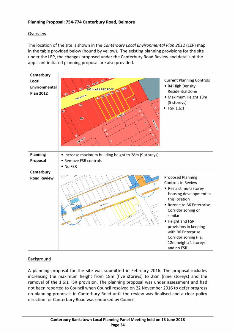
Planning Proposal: 754-774 Canterbury Road, Belmore Overview The location of the site is shown in the Canterbury Local Environmental Plan 2012 (LEP) map in the table provided below (bound by yellow). The existing planning provisions for the site under the LEP, the changes proposed under the Canterbury Road Review and details of the applicant initiated planning proposal are also provided.
Canterbury
Local
Environmental
Plan 2012
Current Planning Controls
• R4 High Density Residential Zone
• Maximum Height 18m (5 storeys)
• FSR 1.6:1
Planning
Proposal
• Increase maximum building height to 28m (9 storeys)
• Remove FSR controls
• No FSR
Canterbury
Road Review
Proposed Planning Controls in Review
• Restrict multi storey housing development in this location
• Rezone to B6 Enterprise Corridor zoning or similar
• Height and FSR provisions in keeping with B6 Enterprise Corridor zoning (i.e. 12m height/4 storeys and no FSR)
Background A planning proposal for the site was submitted in February 2016. The proposal includes increasing the maximum height from 18m (five storeys) to 28m (nine storeys) and the removal of the 1.6:1 FSR provision. The planning proposal was under assessment and had not been reported to Council when Council resolved on 22 November 2016 to defer progress on planning proposals in Canterbury Road until the review was finalised and a clear policy direction for Canterbury Road was endorsed by Council.

Canterbury Bankstown Local Planning Panel Meeting held on 13 June 2018 Page 35
A submission in relation to the land was received during the exhibition of the Review. A copy of the submission, along with the applicant submitted planning proposal and the supporting urban design report have been provided to the Canterbury Bankstown Local Planning Panel.
Assessment The land is currently zoned R4 High Density Residential under the CLEP (refer to CLEP zoning map in the above figure). The R4 High Density Residential zone permits high density residential development, i.e. residential flat buildings. The land to the west and north is zoned R4 High Density Residential, while the land to the east is zoned B5 Business Development and land to the south is zoned R3 Medium Density Residential. The R3 Medium Density Residential and R4 High Density Residential zoned land is predominantly utilised for single dwelling houses with a residential flat building to the very west of the site which is social housing provided by the Land and Housing Corporation. The B5 Business Development land is currently used as a car sales yard. The land is located opposite two localities in Canterbury Road, i.e. the Chapel Street Locality and the locality opposite Trafalgar Street. It is not located within a junction under the Review. The localities are marked by dark blue circles and are on the northern side of Canterbury Road. Recommendation 3 of the Review (see page 25 of the Review document) states that land between the junctions and localities on Canterbury Road should exclude high rise residential development, including the subject site. The reasons for this include: • High rise residential development as part of a mixed use development is proposed to
be concentrated within the identified junctions and localities to support more feasible development outcomes in those locations than what is currently being achieved throughout the corridor (noting the amount of vacant retail floor space).
• High density residential development to the north of Canterbury Road can back onto the road, open to the north, providing better amenity and design outcomes for residents and shield other sites to the north from the adverse traffic impacts from Canterbury Road. This cannot be achieved by high density housing development on land on the southern side of Canterbury Road, including the subject site, and recent development has demonstrated this.
The implications of proceeding with the planning proposal would include: • Support for a proposal that does not demonstrate adequate strategic or ‘site’ specific
justification given the proposed scale of development. • The proposed 28m height (nine storeys) and ‘no FSR’ controls are inconsistent with the
Review. • Continuing to allow high density residential development forms of an inappropriate
scale that negatively impact on the corridor amenity and the quality of life for residents in proximity, in particular the adjoining property at 1a Trafalgar Street, Belmore.
• Isolating the adjoining land at 1a Trafalgar Street, Belmore from redevelopment. • Transport and traffic impacts from high density residential development that would
contradict the approach agreed by the government agency stakeholders on the steering committee for the Review (i.e. RMS, Transport for NSW, the Greater Sydney Commission and the Department of Planning and Environment).

Canterbury Bankstown Local Planning Panel Meeting held on 13 June 2018 Page 36
It is noted that the site has considerable development potential under the existing controls that the applicant can take up (i.e. the R4 High Density Residential zoning, maximum building height of 18m/five storeys and FSR of 1.6:1) and that the increased density proposed beyond the existing controls in the planning proposal would unnecessarily further exacerbate the above implications. For the above reasons, it is considered that no action should be taken in relation to the planning proposal. It is noted that appropriate zoning, planning and development controls for the land will be considered when land outside the junctions and localities is considered as per Recommendation 3.
Canterbury Bankstown Local Planning Panel - 13 June 2018
Canterbury Bankstown Local Planning Panel Meeting held on 13 June 2018 Page 37
ITEM 4 Planning Proposal: 1112-1186 Canterbury Road, Roselands
AUTHOR Planning
PURPOSE AND BACKGROUND
The former Canterbury City Council was in receipt of applications to prepare planning proposals along Canterbury Road, and had also initiated its own planning proposals in the corridor prior to amalgamation with the former Bankstown City Council. The planning proposals have not been progressed due to a Council resolution of 22 November 2016 that deferred progress on planning proposals in the corridor until the Canterbury Road Review is finalised, and a clear policy direction for Canterbury Road is endorsed by Council. This included a proposal for 1112-1186 Canterbury Road, Roselands.
A report on the exhibition of the Review was considered by Council on 22 May 2018 seeking Council’s in-principle support for the Review and to seek endorsement of the next steps. It is now appropriate to make a decision on the outstanding planning proposals, including this planning proposal for this site.
ISSUE The report recommends that the planning proposal not be supported for the following reasons: • The inadequate level of justification provided to rezone employment land to another
use (i.e. the proposed rezoning of B6 Enterprise Corridor zoned land). • Inconsistency with Ministerial Directions (Section 9.1 Directions) and the South District
Plan in relation to the proposal to rezone employment land to another use. • The subject land is not within a proposed junction or locality pursuant to the
Canterbury Road Review. • The proposed no FSR is not in accordance to the Canterbury Road Review which has
found that undesirable development outcomes result from not applying an FSR, i.e. high density residential development can be of a scale that negatively impacts on amenity and the quality of life for residents within or in proximity to the corridor.
RECOMMENDATION That -
1. Council not proceed with the planning proposal for land at 1112-1186 Canterbury Road, Roselands.
2. The current B6 Enterprise Corridor zoning of the land be retained, including the maximum height and FSR controls.
ATTACHMENTS Nil

Canterbury Bankstown Local Planning Panel Meeting held on 13 June 2018 Page 38
POLICY IMPACT There will be no policy impact as the recommendation is in accordance to the policy direction for Canterbury Road adopted by Council at its meeting of 22 May 2018.
FINANCIAL IMPACT
At this stage, progressing with the staff recommendation in relation to the planning proposal would have no financial implications for Council.
COMMUNITY IMPACT The Canterbury Road Review was undertaken partly as a result of strong community feedback in relation to the quantity and design quality of housing developments in the corridor. The Review recommendations are focussed on improved amenity through increasing open space, pedestrian connections, public domain improvements, building design and other outcomes. The staff recommendation in relation to the planning proposal is consistent with the Review and proceeding with the recommendation would result in a positive community impact.

Canterbury Bankstown Local Planning Panel Meeting held on 13 June 2018 Page 39
DETAILED INFORMATION Canterbury Road Review The Canterbury Local Environmental Plan 2012 (LEP), adopted by the former Canterbury City Council on 1 January 2013, established the current planning framework for the Canterbury Road Corridor. The Canterbury Residential Development Strategy (RDS), adopted by the former Canterbury City Council in 2014, was prepared to ensure that the LEP comprises appropriate zonings and development controls to guide and cater for housing growth, consistent with the State government housing agenda through to 2031. Notwithstanding the 2012 LEP and the 2014 RDS, the scale and quantum of development that has been approved and developed is inconsistent with the strategic direction for Canterbury Road and led to development that is of a bulk and size that does not balance amenity and solar access or provide best practice in relation to urban renewal along busy roads. In this regard, the Canterbury Road Review was prompted by: • Issues and impacts associated with additional development and resulting dwelling
yield from approved developments that exceed the height and floor space ratio (FSR) controls that were not contemplated when the LEP was made or by the RDS.
• The lack of an FSR control has resulted in large bulky overly-dense built forms that negatively impact on the corridor amenity and the quality of life for residents in proximity to these buildings.
• A comprehensive submission from Roads and Maritime Service (RMS) expressing concerns about cumulative traffic impacts from the proposed rezoning of land to B5 Business Development under the LEP for residential uses with increased yields in Canterbury Road.
• A large number of privately led planning proposals that seek to increase the development potential of numerous development sites with site specific amendments to the LEP.
• The release of government strategies and infrastructure projects such as the draft South District Plan, the draft Sydenham to Bankstown Urban Renewal Strategy and WestConnex.
• The relatively low level of development occurring in the R3 Medium Density Residential and R4 High Density Residential zones under the LEP.
In response to the above, Council resolved on 26 July 2016 and later on 23 August 2016 to: • Commence a strategic review of the existing policy framework for the Corridor. • Adopt a methodology to guide a strategic review of the Corridor. • Endorse the establishment of an agency Steering Committee comprising
representatives from Council, the Department of Planning and Environment (DP&E), RMS, Transport for NSW (TfNSW) and Greater Sydney Commission (GSC).
The outcome of the Canterbury Road Review includes a standalone report, three specialist consultant studies prepared to inform the review and 15 recommendations endorsed by the Steering Committee in relation to land use, built form and urban amenity and infrastructure.

Canterbury Bankstown Local Planning Panel Meeting held on 13 June 2018 Page 40
The consultant studies are in relation to specific issues as follows: • Urban Design Study – Hill Thalis Architecture + Urban Projects Pty Ltd (Hill Thalis). • Economic Analysis – SGS Economics and Planning (SGS). • Transport and Traffic Study – GHD. A copy of the Canterbury Road Review has been provided to Panel members under separate cover and is also available on Council’s website, including technical studies. It is intended that the Review, including recommendations, will be used by a range of Council and other stakeholders, including the NSW State agencies, to: • Guide changes to land use planning and built form controls along the corridor. • Provide the evidence to support informed decisions and advocacy to government in
relation to current and future growth and infrastructure strategies. • Establish a long-term plan for investment in and enhancement of urban amenities,
open space, active transport, street design and other infrastructure in the Canterbury Road Corridor and surrounding land.
• Support requests for government support and funding to aid in the delivery of some of the recommendations, for example the GSC’s Metropolitan Greenspace Program.
• Inform decisions on planning proposals related to the corridor and surrounding land. The recommendations of the Review detailed in the report were endorsed for public exhibition at the final agency Steering Committee on 30 June 2017. A letter received by Council on 3 July 2017 from the RMS further confirmed their endorsement of the Review for exhibition. Council also resolved to place the Review on exhibition on 25 July 2017 and that the results of the exhibition be reported back to Council. The results of exhibition of the Review were reported back to Council at its meeting on 22 May 2018. A copy of that report has been provided under separate cover to Panel members but is also available for viewing on Council’s website. Outstanding planning proposals in Canterbury Road In recent years a number of applicant initiated planning proposals along Canterbury Road have been lodged with Council, and some have been initiated by the former Canterbury City Council. There are six applicant initiated planning proposals and a further three Council initiated planning proposals which have not progressed due to an unresolved objection by the RMS. Council also resolved on 22 November 2016 to defer a decision on those planning proposals until the Canterbury Road Review was finalised and a clear policy direction endorsed.

Canterbury Bankstown Local Planning Panel Meeting held on 13 June 2018 Page 41
The status and address of each outstanding planning proposal is outlined in Table 1 below.
Status Properties Total
Applicant initiated planning proposals received but not submitted to DP&E for Gateway Determination
• 251-267 Canterbury Road, Canterbury
• 677-687 Canterbury Road and 46-48 Drummond Street, Belmore
• 754-774 Canterbury Road, Belmore
3
Applicant initiated planning proposal submitted for Gateway Determination not in form of latest Council resolution and not determined by DP&E
• 1499 Canterbury Road (998 Punchbowl Road), Punchbowl
1
Applicant initiated planning proposals with Gateway Determination – Conditional approvals
• 538-546 Canterbury Rd Campsie and 570-580 Canterbury Road, Belmore
• 642-644 Canterbury Road, 650-658 Canterbury Road, 1-3 Platts Avenue and 2A-2D Liberty Street, Belmore
2
Sites part of the exhibited RDS planning proposal that did not proceed due to unresolved RMS objection
• 403-411 Canterbury Rd, 1 Una St & block bounded by Canterbury Rd, Duke St, Perry St and Stanley St, Campsie
• 1112-1186 Canterbury Rd, Roselands
• 1375 Canterbury Road, Punchbowl
3
Total 9
Table 1: Status of Planning Proposals in Canterbury Road Applicant initiated planning proposals All of the applicant initiated planning proposals seek to permit development that would exceed the agreed vision for the Canterbury Road Corridor, including the planning controls, as proposed by the Review. Four applicant initiated planning proposals have no formal status and would require Gateway approvals to proceed. Gateway approval is granted by the Greater Sydney Commission by deciding that the planning proposal can proceed (with or without variation). If determined to proceed, the planning proposal may then be subject to other matters including further studies, public consultation, public hearings, agency consultation and time frames. Without Gateway approval, a planning proposal cannot proceed to exhibition or finalisation. Council initiated planning proposals with an unresolved objection by the RMS Three sites that the former Canterbury City Council resolved to rezone (and/or increase the height controls) as part of a planning proposal were intended to implement its RDS. The proposed changes to planning controls for these sites were exhibited as part of the broader planning proposal for the RDS, but were removed due to an unresolved objection from the RMS relating to traffic impact. The sites that remained in the RDS planning proposal were eventually made (gazetted). Consequently, the proposals for the remaining three sites, including the planning proposal for the subject site, have no formal status and would require a new Council resolution and planning proposal if they were to be progressed.

Canterbury Bankstown Local Planning Panel Meeting held on 13 June 2018 Page 42
Review of planning proposals in relation to Canterbury Road Review Recommendation 15 of the Review states that Council will assess the above outstanding planning proposals for consistency with the Review. Recommendation 15 is outlined in full on page 37 of the Canterbury Road Review document. A review of each planning proposal with a recommendation in relation to the consistency of the proposals with the Review has been undertaken. The advice provided by the Panel in relation to each planning proposal will inform the report back to Council for a decision as to whether or not to proceed.
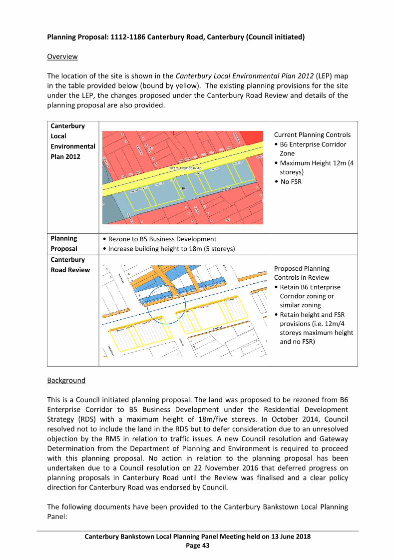
Canterbury Bankstown Local Planning Panel Meeting held on 13 June 2018 Page 43
Planning Proposal: 1112-1186 Canterbury Road, Canterbury (Council initiated) Overview The location of the site is shown in the Canterbury Local Environmental Plan 2012 (LEP) map in the table provided below (bound by yellow). The existing planning provisions for the site under the LEP, the changes proposed under the Canterbury Road Review and details of the planning proposal are also provided.
Canterbury
Local
Environmental
Plan 2012
Current Planning Controls
• B6 Enterprise Corridor Zone
• Maximum Height 12m (4 storeys)
• No FSR
Planning
Proposal
• Rezone to B5 Business Development
• Increase building height to 18m (5 storeys)
Canterbury
Road Review
Proposed Planning Controls in Review
• Retain B6 Enterprise Corridor zoning or similar zoning
• Retain height and FSR provisions (i.e. 12m/4 storeys maximum height and no FSR)
Background This is a Council initiated planning proposal. The land was proposed to be rezoned from B6 Enterprise Corridor to B5 Business Development under the Residential Development Strategy (RDS) with a maximum height of 18m/five storeys. In October 2014, Council resolved not to include the land in the RDS but to defer consideration due to an unresolved objection by the RMS in relation to traffic issues. A new Council resolution and Gateway Determination from the Department of Planning and Environment is required to proceed with this planning proposal. No action in relation to the planning proposal has been undertaken due to a Council resolution on 22 November 2016 that deferred progress on planning proposals in Canterbury Road until the Review was finalised and a clear policy direction for Canterbury Road was endorsed by Council. The following documents have been provided to the Canterbury Bankstown Local Planning Panel:

Canterbury Bankstown Local Planning Panel Meeting held on 13 June 2018 Page 44
• Two separate submissions from the Roads and Maritime Services; • Copies of the documents submitted with the planning proposal, including
- Extract from the exhibited Residential Development Strategy Planning Proposal; - Planning Proposal Gateway Determination.
Assessment The land is currently zoned B6 Enterprise Corridor which allows business, office, retail and light industrial uses. Land to the east and north is zoned R3 Medium Density Residential and land to the west of the land is zoned B5 Business Development. Further south of Canterbury Road, the land is predominantly zoned R3 Medium Density Residential zone. The land zoned B5 Business Development and B6 Enterprise Corridor zone is predominantly used for business and light industrial uses. This is consistent with those zones. Land in the R3 Medium Density Residential zone is predominantly used for single dwelling houses also consistent with uses permitted by that zoning. Under section 9.1 of the Environmental Planning and Assessment Act 1979 (formerly Section 117 Directions), Council is required to consider policy directions for plan making (i.e. for amending the CLEP). Ministerial Direction 1.1 relates to retaining areas and locations of existing business and industrial zones and Direction 7.1 relates to the NSW Government’s ‘A Plan for Growing Sydney’. Under both directions, strong justification must be provided for rezoning employment land to another use. Under Planning Priority S10 of the Greater Sydney Commission’s South District Plan, industrial and urban services land such as the B6 Enterprise Corridor zone is to be planned, retained and managed. This plan was released in March 2018 and although not part of the planning controls when the planning proposal was submitted, Council is now required to include consideration of it as part of the overall assessment. It is noted that Action 39 of the plan further states: ‘Retain and manage industrial and urban services land, in line with the Principles for managing industrial and urban services land, in the South District by safeguarding all industrial zoned land from conversion to residential development, including conversion to mixed-use zones. In updating local environmental plans, councils are to conduct a strategic review of industrial lands.’ The economic analysis completed by SGS Economics and Planning as part of the Review has indicated that employment lands along Canterbury Road will continue to be in demand for employment uses, including bulky goods retailing and light industry. The demand for employment uses in the proposed rezoning of the B6 Enterprise Corridor zoned land for other purposes (including residential) would need to be further investigated and justified as per the section 9.1 directions and in consideration of the South District Plan. Regardless of the employment lands issue, it is noted that within the Review the land is to the south of the Renown Avenue Locality (see above figure for location of locality bound by a dark blue line). Under the Review, land to the south of Canterbury Road is not included in localities as high rise housing to the south of Canterbury Road is considered undesirable. High density residential development on the northern side of Canterbury Road as proposed in the Review vision would be designed to maximise amenity and produce high quality design outcomes for residents and shield development from the adverse traffic impacts from

Canterbury Bankstown Local Planning Panel Meeting held on 13 June 2018 Page 45
Canterbury Road. This cannot be as effectively achieved by high density housing development on land on the southern side of Canterbury Road and as such the land is not considered suitable for high rise residential housing as proposed in the planning proposal. It is also noted that the proposed controls (i.e. the proposed maximum 18m/five storey height limit and no FSR) would not form the basis to deliver an appropriate planning outcome. The Review has highlighted that the poor development outcomes that often result from not applying an FSR, i.e. high density residential development of a scale that negatively impacts on the corridor amenity and the quality of life for residents in proximity. Transport and traffic impacts would also result from the proposed high density housing development which is inconsistent with the approach agreed by the government agency stakeholders on the steering committee for the Review (i.e. RMS, Transport for NSW, the Greater Sydney Commission and the Department of Planning and Environment). For these reasons, it is considered that the planning proposal cannot be supported in its current form.

Canterbury Bankstown Local Planning Panel Meeting held on 13 June 2018 Page 46

Canterbury Bankstown Local Planning Panel - 13 June 2018
Canterbury Bankstown Local Planning Panel Meeting held on 13 June 2018 Page 47
ITEM 5 Planning Proposal: 1375 Canterbury Road, Punchbowl
AUTHOR Planning
PURPOSE AND BACKGROUND
The former Canterbury City Council was in receipt of applications to prepare planning proposals along Canterbury Road, and had also initiated its own planning proposals in the corridor prior to amalgamation with the former Bankstown City Council. The planning proposals have not been progressed due to a Council resolution of 22 November 2016 that deferred progress on planning proposals in the corridor until the Canterbury Road Review is finalised, and a clear policy direction for Canterbury Road is endorsed by Council. This included a Council initiated proposal for 1375 Canterbury Road, Punchbowl (also known as the Godfreys site).
A report on the exhibition of the Review was considered by Council on 22 May 2018 seeking Council’s in-principle support for the Review and to seek endorsement of the next steps. It is now appropriate to make a decision on the outstanding planning proposals, including the planning proposal for this site.
ISSUE The report recommends that the planning proposal not be supported for the following reasons: • The controls will result in the continuation of high density residential development
forms at a scale that negatively impact on the corridor amenity and the quality of life for residents within or in proximity to the corridor.
• Appropriate planning controls will be explored as part of the next steps of the Canterbury Road Review and in the context of the rest of the Victoria Road Locality.
• The current planning proposal has no formal status and would require a fresh Gateway Determination to proceed (i.e. it could simply be amended).
• Council needs to carefully consider whether to rezone land from employment purposes to a mixed use zone.
• Justification for rezoning employment land to another use (i.e. the proposed rezoning of B6 Enterprise Corridor zoned land) can be further examined when the boundaries of the locality are determined.
• Inconsistency with relevant Ministerial Directions (Section 9.1 Directions) and the South District Plan in relation to the proposal to rezone employment land to another use.
RECOMMENDATION That -
1. Council not proceed with the planning proposal at 1375 Canterbury Road, Punchbowl. 2. The planning provisions of the site be reviewed when the boundaries of the Victoria
Road Locality are determined.

Canterbury Bankstown Local Planning Panel Meeting held on 13 June 2018 Page 48
ATTACHMENTS Nil
Canterbury Bankstown Local Planning Panel Meeting held on 13 June 2018 Page 49
POLICY IMPACT There will be no policy impact as the recommendation is in accordance to the policy direction for Canterbury Road adopted by Council at its meeting of 22 May 2018.
FINANCIAL IMPACT
At this stage, progressing with the staff recommendation in relation to the planning proposal would have no financial implications for Council.
COMMUNITY IMPACT The Canterbury Road Review was undertaken partly as a result of strong community feedback in relation to the quantity and design quality of housing developments in the corridor. The Review recommendations are focussed on improved amenity through increasing open space, pedestrian connections, public domain improvements, building design and other outcomes. The staff recommendation in relation to the planning proposal is consistent with the Review and proceeding with the recommendation would result in a positive community impact.

Canterbury Bankstown Local Planning Panel Meeting held on 13 June 2018 Page 50
DETAILED INFORMATION Canterbury Road Review The Canterbury Local Environmental Plan 2012 (LEP), adopted by the former Canterbury City Council on 1 January 2013, established the current planning framework for the Canterbury Road Corridor. The Canterbury Residential Development Strategy (RDS), adopted by the former Canterbury City Council in 2014, was prepared to ensure that the LEP comprises appropriate zonings and development controls to guide and cater for housing growth, consistent with the State government housing agenda through to 2031. Notwithstanding the 2012 LEP and the 2014 RDS, the scale and quantum of development that has been approved and developed is inconsistent with the strategic direction for Canterbury Road and led to development that is of a bulk and size that does not balance amenity and solar access or provide best practice in relation to urban renewal along busy roads. In this regard, the Canterbury Road Review was prompted by: • Issues and impacts associated with additional development and resulting dwelling
yield from approved developments that exceed the height and floor space ratio (FSR) controls that were not contemplated when the LEP was made or by the RDS.
• The lack of an FSR control has resulted in large bulky overly-dense built forms that negatively impact on the corridor amenity and the quality of life for residents in proximity to these buildings.
• A comprehensive submission from Roads and Maritime Service (RMS) expressing concerns about cumulative traffic impacts from the proposed rezoning of land to B5 Business Development under the LEP for residential uses with increased yields in Canterbury Road.
• A large number of privately led planning proposals that seek to increase the development potential of numerous development sites with site specific amendments to the LEP.
• The release of government strategies and infrastructure projects such as the draft South District Plan, the draft Sydenham to Bankstown Urban Renewal Strategy and WestConnex.
• The relatively low level of development occurring in the R3 Medium Density Residential and R4 High Density Residential zones under the LEP.
In response to the above, Council resolved on 26 July 2016 and later on 23 August 2016 to: • Commence a strategic review of the existing policy framework for the Corridor. • Adopt a methodology to guide a strategic review of the Corridor. • Endorse the establishment of an agency Steering Committee comprising
representatives from Council, the Department of Planning and Environment (DP&E), RMS, Transport for NSW (TfNSW) and Greater Sydney Commission (GSC).
The outcome of the Canterbury Road Review includes a standalone report, three specialist consultant studies prepared to inform the review and 15 recommendations endorsed by the Steering Committee in relation to land use, built form and urban amenity and infrastructure.
Canterbury Bankstown Local Planning Panel Meeting held on 13 June 2018 Page 51
The consultant studies are in relation to specific issues as follows: • Urban Design Study – Hill Thalis Architecture + Urban Projects Pty Ltd (Hill Thalis). • Economic Analysis – SGS Economics and Planning (SGS). • Transport and Traffic Study – GHD. A copy of the Canterbury Road Review has been provided to Panel members under separate cover and is also available on Council’s website, including technical studies. It is intended that the Review, including recommendations, will be used by a range of Council and other stakeholders, including the NSW State agencies, to: • Guide changes to land use planning and built form controls along the corridor. • Provide the evidence to support informed decisions and advocacy to government in
relation to current and future growth and infrastructure strategies. • Establish a long-term plan for investment in and enhancement of urban amenities,
open space, active transport, street design and other infrastructure in the Canterbury Road Corridor and surrounding land.
• Support requests for government support and funding to aid in the delivery of some of the recommendations, for example the GSC’s Metropolitan Greenspace Program.
• Inform decisions on planning proposals related to the corridor and surrounding land. The recommendations of the Review detailed in the report were endorsed for public exhibition at the final agency Steering Committee on 30 June 2017. A letter received by Council on 3 July 2017 from the RMS further confirmed their endorsement of the Review for exhibition. Council also resolved to place the Review on exhibition on 25 July 2017 and that the results of the exhibition be reported back to Council. The results of exhibition of the Review were reported back to Council at its meeting on 22 May 2018. A copy of that report has been provided under separate cover to Panel members but is also available for viewing on Council’s website. Outstanding planning proposals in Canterbury Road In recent years a number of applicant initiated planning proposals along Canterbury Road have been lodged with Council, and some have been initiated by the former Canterbury City Council. There are six applicant initiated planning proposals and a further three Council initiated planning proposals which have not progressed due to an unresolved objection by the RMS. Council also resolved on 22 November 2016 to defer a decision on those planning proposals until the Canterbury Road Review was finalised and a clear policy direction endorsed.

Canterbury Bankstown Local Planning Panel Meeting held on 13 June 2018 Page 52
The status and address of each outstanding planning proposal is outlined in Table 1 below.
Status Properties Total
Applicant initiated planning proposals received but not submitted to DP&E for Gateway Determination
• 251-267 Canterbury Road, Canterbury
• 677-687 Canterbury Road and 46-48 Drummond Street, Belmore
• 754-774 Canterbury Road, Belmore
3
Applicant initiated planning proposal submitted for Gateway Determination not in form of latest Council resolution and not determined by DP&E
• 1499 Canterbury Road (998 Punchbowl Road), Punchbowl
1
Applicant initiated planning proposals with Gateway Determination – Conditional approvals
• 538-546 Canterbury Rd Campsie and 570-580 Canterbury Road, Belmore
• 642-644 Canterbury Road, 650-658 Canterbury Road, 1-3 Platts Avenue and 2A-2D Liberty Street, Belmore
2
Sites part of the exhibited RDS planning proposal that did not proceed due to unresolved RMS objection
• 403-411 Canterbury Rd, 1 Una St & block bounded by Canterbury Rd, Duke St, Perry St and Stanley St, Campsie
• 1112-1186 Canterbury Rd, Roselands
• 1375 Canterbury Road, Punchbowl
3
Total 9
Table 1: Status of Planning Proposals in Canterbury Road Applicant initiated planning proposals All of the applicant initiated planning proposals seek to permit development that would exceed the agreed vision for the Canterbury Road Corridor, including the planning controls, as proposed by the Review. Four have no formal status and would require Gateway approvals to proceed. Gateway approval is granted by the Greater Sydney Commission by deciding that the planning proposal can proceed (with or without variation). If determined to proceed, the planning proposal may then be subject to other matters including further studies, public consultation, public hearings, agency consultation and time frames. Without Gateway approval, a planning proposal cannot proceed to exhibition or finalisation. Council initiated planning proposals with an unresolved objection by the RMS Three sites that the former Canterbury City Council resolved to rezone (and/or increase the height controls) as part of a planning proposal were intended to implement its RDS. The proposed changes to planning controls for these sites were exhibited as part of the broader planning proposal for the RDS, but were removed due to an unresolved objection from the RMS relating to traffic impact. The sites that remained in the RDS planning proposal were eventually made (gazetted). Consequently, the proposals for the remaining three sites, including the proposal for the subject site, have no formal status and would require a new Council resolution and planning proposal if they were to be progressed.

Canterbury Bankstown Local Planning Panel Meeting held on 13 June 2018 Page 53
Review of planning proposals in relation to Canterbury Road Review Recommendation 15 of the Review states that Council will assess the above outstanding planning proposals for consistency with the Review. Recommendation 15 is outlined in full on page 37 of the Canterbury Road Review document. A review of each planning proposal with a recommendation in relation to the consistency of the proposals with the Review has been undertaken. The advice provided by the Panel in relation to each planning proposal will inform the report back to Council for a decision as to whether or not to proceed.
Canterbury Bankstown Local Planning Panel Meeting held on 13 June 2018 Page 54
Planning Proposal: 1375 Canterbury Road, Canterbury (Council initiated) Overview The location of the site is shown in the Canterbury Local Environmental Plan 2012 (LEP) map in the table provided below (bound by yellow). The existing planning provisions for the site under the LEP, the changes proposed under the Canterbury Road Review and details of the applicant initiated planning proposal are also provided.
Canterbury
Local
Environmental
Plan 2012
Current Planning Controls
• B6 Enterprise Corridor Zone
• Maximum Height 12m (4 Storeys)
• No FSR
Planning
Proposal
• Rezone to B5 Business Development
• Increase building height to 18m (5 storeys)
Canterbury
Road Review
Proposed Planning Controls in Review
• Victoria Road Locality
• B2 Local Centre Zone or similar
• 4-6 Storeys
Background The land was proposed to be rezoned from B6 Enterprise Corridor to B5 Business Development under the RDS with a maximum height of 18m (5 storeys). In October 2014, Council resolved not to include the land in the RDS but to defer consideration due to an unresolved objection by the RMS in relation to traffic issues. A new Council resolution and Gateway Determination from the Department of Planning and Environment is required to proceed with this planning proposal. No action in relation to the planning proposal has been

Canterbury Bankstown Local Planning Panel Meeting held on 13 June 2018 Page 55
undertaken due to a Council resolution on 22 November 2016 that deferred progress on planning proposals in Canterbury Road until the Review was finalised and a clear policy direction for Canterbury Road was endorsed by Council. The following documents have been provided to the Canterbury Bankstown Local Planning Panel: • Two separate submissions from the Roads and Maritime Services; • Copies of the documents submitted with the planning proposal, including:
- Extract from the exhibited Residential Development Strategy Planning Proposal; and
- Planning Proposal Gateway Determination. Assessment Under section 9.1 of the Environmental Planning and Assessment Act 1979 (formerly Section 117 Directions), Council is required to consider policy directions for plan making (i.e. for amending the CLEP). Ministerial Direction 1.1 relates to retaining areas and locations of existing business and industrial zones and Direction 7.1 relates to the NSW Government’s ‘A Plan for Growing Sydney’. Under both directions, clear justification must be provided for rezoning employment land to another use. Under Planning Priority S10 of the Greater Sydney Commission’s South District Plan, industrial and urban services land such as the B6 Enterprise Corridor zone is to be planned, retained and managed. This Plan was released in March 2018 and although not part of the planning controls when the planning proposal was submitted, Council is now required to include consideration of it as part of the overall assessment. It is noted that Action 39 of the Plan further states: ‘Retain and manage industrial and urban services land, in line with the Principles for managing industrial and urban services land, in the South District by safeguarding all industrial zoned land from conversion to residential development, including conversion to mixed-use zones. In updating local environmental plans, councils are to conduct a strategic review of industrial lands.’ The economic analysis completed by SGS Economics and Planning as part of the review has indicated that employment lands along Canterbury Road will continue to be in demand for employment uses, including bulky goods retailing and light industry. The demand for employment uses in the proposed rezoning of the B6 Enterprise Corridor zoned land for other purposes (including residential) would need to be further investigated and justified as per the section 9.1 Directions and in consideration of the South District Plan. Within the Review, it is noted that the land is located within close proximity to the Victoria Road Locality (see above figure). High density housing with a maximum of six storeys is proposed for the locality requiring a rezoning to permit revised planning rules in that location. Action A of Recommendation 2 of the Review requires that the area for each locality be determined based on further studies and the results of the exhibition of the Review (see page 21 of the Review document). This includes determining appropriate zonings, maximum height, FSR and other provisions, including amendments to the Canterbury Development Control Plan 2012. Council resolved to commence this further work on 22 May 2018.

Canterbury Bankstown Local Planning Panel Meeting held on 13 June 2018 Page 56
It is recommended not to proceed with the planning proposal because: • The controls will result in the continuation of high density residential development
forms at a scale that negatively impact on the corridor amenity and the quality of life for residents in proximity.
• Appropriate planning controls will be explored as part of the next steps of the Review and in the context of the rest of the Victoria Road Locality, consistent with recent resolution of Council.
• The current planning proposal has no formal status and would require a fresh Gateway Determination to proceed (i.e. it could simply be amended).
• Council needs to carefully consider whether to rezone land from employment purposes to a mixed use zone. This would require a clear evidence base to be demonstrated and agreement from the Department of Planning and Environment reached. As discussed above, the demand for employment uses in the proposed rezoning of the B6 Enterprise Corridor zoned land for other purposes (including residential) needs to be investigated and justified as per the section 9.1 Directions and in consideration of the South District Plan.

Canterbury Bankstown Local Planning Panel - 13 June 2018
Canterbury Bankstown Local Planning Panel Meeting held on 13 June 2018 Page 57
ITEM 6 Planning Proposal: 642-644 Canterbury Road, 650-658 Canterbury Road, 1-3 Platts Avenue and 2, 2A-2D Liberty Street, Belmore
AUTHOR Planning
PURPOSE AND BACKGROUND
The former Canterbury City Council was in receipt of applications to prepare planning proposals along Canterbury Road, and had also initiated its own planning proposals in the corridor prior to amalgamation with the former Bankstown City Council. The planning proposals have not been progressed due to a Council resolution of 22 November 2016 that deferred progress on planning proposals in the corridor until the Canterbury Road Review is finalised, and a clear policy direction for Canterbury Road is endorsed by Council. This included an applicant initiated proposal for 642-644 Canterbury Road, 650-658 Canterbury Road, 1-3 Platts Avenue and 2A-2D Liberty Street, Belmore. A report on the exhibition of the review was considered by Council on 22 May 2018 seeking Council’s in-principle support of the findings and recommendations of the review and to seek endorsement for further work aimed at setting a new policy direction for Canterbury Road. The planning proposal was considered by the Canterbury Bankstown Local Planning Panel on Tuesday 5 June 2018, when the Panel recommended that the item be deferred to the Canterbury Bankstown Local Planning Panel meeting on Wednesday 13 June 2018, to allow the applicants to respond to matters raised in the planning report.
ISSUE
This report recommends that the planning proposal not be supported for a number of reasons being: • Insufficient justification has been provided for rezoning employment land to another
alternate use (i.e. the proposed rezoning of B6 Enterprise Corridor zoned land). • The subject land is not within a proposed junction or locality pursuant to the
Canterbury Road Review. • The proposed maximum height and FSR is not in keeping with the maximum height of 6
storeys and the maximum FSR of 2.5:1 (residential 1.9:1 and 0.6:1 commercial) defined in the review.
RECOMMENDATION That -
The planning proposal not be proceeded with for 642-644 Canterbury Road, 650-658 Canterbury Road, 1-3 Platts Avenue and 2, 2A-2D Liberty Street, Belmore for the reasons outlined in this report.

Canterbury Bankstown Local Planning Panel Meeting held on 13 June 2018 Page 58
ATTACHMENTS
Nil
Canterbury Bankstown Local Planning Panel Meeting held on 13 June 2018 Page 59
POLICY IMPACT
There will be no policy impact as the recommendation is in accordance with the policy direction for Canterbury Road adopted by Council at its meeting of 22 May 2018.
FINANCIAL IMPACT
At this stage, progressing with the staff recommendation in relation to the planning proposal would have no financial implications for Council.
COMMUNITY IMPACT
The Canterbury Road Review was undertaken partly as a result of strong community feedback in relation to the quantity and design quality of housing developments in the corridor. The review recommendations are focussed on improved amenity through increasing open space, pedestrian connections, public domain improvements, building design and other outcomes. The staff recommendation in relation to the planning proposal is consistent with the review and proceeding with the recommendation would result in a positive community impact.
Canterbury Bankstown Local Planning Panel Meeting held on 13 June 2018 Page 60
DETAILED INFORMATION Canterbury Road Review The Canterbury Local Environmental Plan 2012 (LEP), adopted by the former Canterbury City Council on 1 January 2013, established the current planning framework for the Canterbury Road Corridor. The Canterbury Residential Development Strategy (RDS), adopted by the former Canterbury City Council in 2014, was prepared to ensure that the LEP comprises appropriate zonings and development controls to guide and cater for housing growth, consistent with the State government’s housing agenda through to 2031. Notwithstanding the 2012 LEP and the 2014 RDS, the scale and quantum of development that has been approved and developed is inconsistent with the strategic direction for Canterbury Road and led to development that is of a bulk and size that does not balance amenity and solar access or provide best practice in relation to urban renewal along busy roads. In this regard, the Canterbury Road Review was prompted by: • Issues and impacts associated with additional development and resulting dwelling
yield from approved developments that exceed the height and floor space ratio (FSR) controls that were not contemplated when the LEP was made or by the RDS.
• The lack of an FSR control has resulted in large bulky overly-dense built forms that negatively impact on the corridor amenity and the quality of life for residents in proximity to these buildings.
• A comprehensive submission from Roads and Maritime Service (RMS) expressing concerns about cumulative traffic impacts from the proposed rezoning of land to B5 Business Development under the LEP for residential uses with increased yields in Canterbury Road.
• A large number of privately led planning proposals that seek to increase the development potential of numerous development sites with site specific amendments to the LEP.
• The release of government strategies and infrastructure projects such as the draft South District Plan, the draft Sydenham to Bankstown Urban Renewal Strategy and WestConnex.
• The relatively low level of development occurring in the R3 Medium Density Residential and R4 High Density Residential zones under the LEP.
In response to the above, Council resolved on 26 July 2016 and later on 23 August 2016 to: • Commence a strategic review of the existing policy framework for the Corridor. • Adopt a methodology to guide a strategic review of the Corridor. • Endorse the establishment of an agency Steering Committee comprising
representatives from Council, the DP&E, RMS, Transport for NSW (TfNSW) and Greater Sydney Commission (GSC).
The outcome of the Canterbury Road review includes a standalone report, three specialist consultant studies prepared to inform the review and 15 recommendations endorsed by the Steering Committee in relation to land use, built form and urban amenity and infrastructure.

Canterbury Bankstown Local Planning Panel Meeting held on 13 June 2018 Page 61
The consultant studies are in relation to specific issues as follows: • Urban Design Study – Hill Thalis Architecture + Urban Projects Pty Ltd (Hill Thalis). • Economic Analysis – SGS Economics and Planning (SGS). • Transport and Traffic Study – GHD. A copy of the Canterbury Road Review has been provided to panel members under separate cover and is also available on Council’s website, including technical studies. It is intended that the review, including recommendations, will be used by a range of Council and other stakeholders, including the NSW State agencies, to: • Guide changes to land use planning and built form controls along the corridor. • Provide the evidence to support informed decisions and advocacy to government in
relation to current and future growth and infrastructure strategies. • Establish a long-term plan for investment in and enhancement of urban amenities,
open space, active transport, street design and other infrastructure in the Canterbury Road Corridor and surrounding land.
• Support requests for government support and funding to aid in the delivery of some of the recommendations, for example the GSC’s Metropolitan Greenspace Program.
• Inform decisions on planning proposals related to the corridor and surrounding land. The recommendations of the review detailed in the report were endorsed for public exhibition at the final agency Steering Committee on 30 June 2017. A letter received by Council on 3 July 2017 from the RMS further confirmed their endorsement of the review for exhibition. Council also resolved to place the review on exhibition on 25 July 2017 and that the results of the exhibition be reported back to Council. The results of exhibition of the review were reported back to Council at its meeting of 22 May 2018. A copy of that report has been provided under separate cover to panel members but is also available for viewing on Council’s website. Outstanding planning proposals in Canterbury Road In recent years a number of applicant initiated planning proposals have been lodged with Council along Canterbury Road, and some have been initiated by the former Canterbury City Council. There are six applicant initiated planning proposals and a further three Council initiated planning proposals which have stalled due to an unresolved objection by the RMS. Council also resolved on 22 November 2016 to defer a decision on those planning proposals until the Canterbury Road Review was finalised and a clear policy direction endorsed.
Canterbury Bankstown Local Planning Panel Meeting held on 13 June 2018 Page 62
The status and address of each outstanding planning proposal is outlined in Table 1 below.
Status Properties Total
Applicant initiated planning proposals received but not submitted to DP&E for Gateway Determination
• 251-267 Canterbury Road, Canterbury
• 677-687 Canterbury Road and 46-48 Drummond Street, Belmore
• 754-774 Canterbury Road, Belmore
3
Applicant initiated planning proposal submitted for Gateway Determination not in form of latest Council resolution and not determined by DP&E
• 1499 Canterbury Road (998 Punchbowl Road), Roselands
1
Applicant initiated planning proposals with Gateway Determination – Conditional approvals
• 538-546 Canterbury Rd Campsie and 570-580 Canterbury Road, Belmore
• 642-644 Canterbury Road, 650-658 Canterbury Road, 1-3 Platts Avenue and 2A-2D Liberty Street, Belmore
2
Sites part of the exhibited RDS planning proposal that did not proceed due to unresolved RMS objection
• 403-411 Canterbury Rd, 1 Una St & block bounded by Canterbury Rd, Duke St, Perry St and Stanley St, Campsie
• 1112-1186 Canterbury Rd, Roselands
• 1375 Canterbury Road, Punchbowl
3
Total 9
Table 1: Status of Planning Proposals in Canterbury Road
Applicant initiated planning proposals All of the applicant initiated planning proposals seek to permit development that would exceed the agreed vision, including the planning controls, for the corridor as proposed by the Review. Four have no formal status and would require Gateway approvals to proceed. Gateway approval is granted by the Greater Sydney Commission by deciding that the planning proposal can proceed (with or without variation). If determined to proceed, the planning proposal may then be subject to other matters including further studies, public consultation, public hearings, agency consultation and time frames. Without Gateway approval, a planning proposal cannot proceed to exhibition or finalisation. Council initiated planning proposals with an unresolved objection by the RMS Three sites that the former Canterbury City Council resolved to rezone (and/or increase the height controls) as part of a planning proposal were intended to implement its RDS. The proposed changes to planning controls for these sites were exhibited as part of the broader planning proposal for the RDS, but were removed due to an unresolved objection from the RMS relating to traffic impact. The sites that remained in the RDS planning proposal were eventually made (gazetted). Consequently, the proposals for the remaining three sites have no formal status and would require a new Council resolution and planning proposal if they were to be progressed.

Canterbury Bankstown Local Planning Panel Meeting held on 13 June 2018 Page 63
Review of planning proposals in relation to Canterbury Road Review Recommendation 15 of the review states that Council will assess the above outstanding planning proposals for consistency with the review. Recommendation 15 is outlined in full on page 37 of the Canterbury Road Review document. A review of each planning proposal with a recommendation in relation to the consistency of the proposals has been undertaken. The advice sought from the panel for each planning proposal will inform the report back to Council for a decision as to whether or not to proceed.
Canterbury Bankstown Local Planning Panel Meeting held on 13 June 2018 Page 64
Planning Proposal: 642 - 658 Canterbury Road, 1-3 Platts Avenue and 2A-2D Liberty St, Belmore (applicant initiated) Overview The location of the site is shown in the Canterbury Local Environmental Plan 2012 (LEP) map in the table provided below (bound by yellow). The existing planning provisions for the site under the LEP, the changes proposed under the Canterbury Road Review and details of the applicant initiated planning proposal are also provided.
Canterbury
Local
Environmental
Plan 2012
Current Planning Controls
• Zoning – Part R3 Medium Density Residential and part B6 Enterprise Corridor
• Maximum Height – Part 8.5m/2 storeys (R3 zone) and part 12m/4 storeys (B6 zone)
• FSR – Part 0.5:1 (R3 zone) and part no FSR (B6 zone)
Planning
Proposal
• Rezone to B5 Business Development
• Range of building heights up to 25 metres (8 storeys)
• Remove FSR controls
Canterbury
Road Review
Proposed Planning Controls by the Review
• Restrict multi storey housing development in this location
• Maintain B6 Enterprise Corridor zoning or similar for land currently zoned B6
• Maintain R3 Medium Density Residential Zone for land currently zoned R3
• Maintain current height and FSR provisions
Background In October 2014, Council resolved not to include the subject site in the Residential Development Strategy (RDS) but to defer consideration to allow more detailed urban design to be undertaken and because of unresolved traffic issues raised by the RMS. The RDS

Canterbury Bankstown Local Planning Panel Meeting held on 13 June 2018 Page 65
proposed to rezone the land from part B6 Enterprise Corridor and part R3 Medium Density Residential to B5 Business Development. The FSR controls were also proposed to be removed, along with amendments to the maximum building heights from 8.5m and 12m to heights ranging across the site to a maximum of 25m (8 storeys) on Canterbury Road. Subsequent to Council’s resolution, a separate planning proposal was lodged with Council in December 2014 that included a development application. A concept design of the proposed built form can be viewed in the statement of environmental effects submitted with the development application of which has been provided to the Canterbury Bankstown Local Planning Panel. The Department of Environment and Planning provided a conditional Gateway determination which enabled exhibition of the planning proposal once issues raised by the RMS had been resolved. The issues were resolved and the planning proposal was exhibited in August 2016. A number of submissions were made which objected to the proposal, including a submission from the owner of the un-amalgamated site at 2 Liberty Street and 650-658 Canterbury Road which forms part of the planning proposal. Site A in the figure below shows the location of that land and Site B is the remaining land the subject of the planning proposal. As shown in the concept design above, Site A has not been included in the development application. A submission in relation to the planning proposal from that landowner has been provided to the Local Planning Panel.
2 Liberty Street and 650-658 Canterbury Rd (Site A)
A significant number of issues remain with the planning proposal which include: • The current planning proposal is seeking controls in excess of that recommended in the
RDS, i.e. a height of 8 storeys and no FSR. The review is proposing a maximum height of 4-6 storeys and an FSR of 2.5:1 (1.9:1 residential and 0.6:1 commercial).

Canterbury Bankstown Local Planning Panel Meeting held on 13 June 2018 Page 66
• Public submissions opposing the proposal, including the owner of the properties within the site.
• Traffic and transport issues for the subject site remain unresolved in relation to cumulative impact.
• Suitability of the development scheme noting a development application for the site has been submitted by the proponent. The proposed scheme in the development application differs to those in the planning proposal. The key differences are; height, internal courtyard dimensions and setback/separation of buildings. A copy of the notification plans for the development application has been provided to the Local Planning Panel.
The planning proposal was not progressed to finalisation after exhibition due to a Council resolution of 22 November 2016 that deferred progress on planning proposals in Canterbury Road until the review was finalised and a clear policy direction for Canterbury Road was endorsed by Council. Council received a submission during the exhibition of the review in relation to the land which has been provided to the Local Planning Panel under separate cover. Copies of the documents submitted with the planning proposal have been provided to the Local Planning Panel and include: • Council Report; • Planning proposal; • Urban Design Study; • Gateway Determination; and • 2 x Roads and Maritime Submissions. Assessment against findings and recommendations of Canterbury Road Review The land is currently zoned B6 Enterprise Corridor and R3 Medium Density Residential. Land to the east is zoned B2 Local Centre, land to the west is zoned B5 Business Development, land to the north is zoned B2 Local Centre and B6 Enterprise Corridor and land to the south is zoned R3 Medium Density Residential (see CLEP zoning map above). The land zoned B2 Local Centre, B5 Business Development and B6 Enterprise Corridor is predominantly used for business and light industrial uses consistent with those zones. Currently, land in the R3 Medium Density Residential zone features single dwelling houses with some townhouses. Under section 9.1 of the Environmental Planning and Assessment Act 1979 (formerly Section 117 Directions), Council is required to consider policy directions for plan making (i.e. for amending the CLEP). Direction 1.1 relates to retaining areas and locations of existing business and industrial zones and Direction 7.1 relates to the NSW Government’s ‘A Plan for Growing Sydney’. Under both directions, strong justification must be provided for rezoning employment land to another use. Under Planning Priority S10 of the Greater Sydney Commission’s South District Plan, industrial and urban services land such as the B6 Enterprise Corridor zone is to be planned, retained and managed. This plan was released in March 2018 and although not part of the
Canterbury Bankstown Local Planning Panel Meeting held on 13 June 2018 Page 67
planning controls when the planning proposal was submitted, Council is now required to include consideration of it as part of the overall assessment. It is noted that Action 39 of the plan further states: ‘Retain and manage industrial and urban services land, in line with the Principles for managing industrial and urban services land, in the South District by safeguarding all industrial zoned land from conversion to residential development, including conversion to mixed-use zones. In updating local environmental plans, councils are to conduct a strategic review of industrial lands.’ The economic analysis completed by SGS Economics and Planning as part of the review has indicated that employment lands along Canterbury Road will continue to be in demand for employment uses, including bulky goods retailing and light industry. The demand for employment uses in the proposed rezoning of the B6 Enterprise Corridor zoned land for other purposes (including residential) would need to be further investigated and justified as per the section 9.1 directions and in consideration of the South District Plan. Regardless of the employment lands issue, rezoning the land to permit high density mixed use development would not be in keeping with the findings and recommendations of the review and as such it is considered that the land should remain in the B6 Enterprise Corridor and R3 Medium Density Residential zone. These findings include (refer to page 25 of Canterbury Road Review document): • The proposed maximum height and density (i.e. no FSR) is not in keeping with the
maximum height of 6 storeys and the maximum FSR of 1.9:1 in the review for development within junctions and localities.
• The junctions and localities in the review have been defined to concentrate development in locations that will provide opportunities for the creation of open space, pedestrian connectivity, take advantage of north/south bus links and result in the lowest levels of additional traffic congestion.
• High density residential development to the north of Canterbury Road can back onto the
road, open to north providing better amenity design outcomes for residents and shields other sites to the north from the adverse traffic impacts from Canterbury Road. This cannot be achieved by high density housing development on the southern side of Canterbury Road such as the subject site and recent development has demonstrated this.
• With a finite supply of single dwellings in the area, there is a high demand for alternate
housing types such as medium density housing, beyond apartment living, that is permitted in the existing R3 Medium Density Residential zone (see above) which includes part of the subject land.
• Additional multi storey housing development will have significant traffic impacts which
have not been modelled. Whilst the development application submitted in this planning proposal is subject to a separate assessment process, the following observations were made: • Height of building exceeds proposed controls (i.e. clause 4.6 was submitted with the
development application);

Canterbury Bankstown Local Planning Panel Meeting held on 13 June 2018 Page 68
• It will be difficult for a development on Site A to comply with the Apartment Design
Guide if developed separately (e.g. ventilation). • The owner of the land of Site A has objected to both the planning proposal and
development application indicating that the development of the site the subject of the planning proposal is unlikely to be realised.
• Subterranean units are proposed which will offer a poor environment for future
residents and is not in keeping with Council intent to improve the quality of development in Canterbury Road.