Affected Natural Environment, Potential Impacts and ...
18
CHAPTER IV Affected Natural Environment, Potential Impacts and Mitigation Measures
Transcript of Affected Natural Environment, Potential Impacts and ...

CHAPTER IV Affected Natural Environment, Potential
Impacts and Mitigation Measures

CHAPTER 4 AFFECTED NATURAL ENVIRONMENT, POTENTIAL IMPACTS AND MITIGATION MEASSURES
WAIKAPŪ COUNTRY TOWN IV-1 DRAFT ENVIRONMENTAL IMPACT STATEMENT
IV. AFFECTED NATURAL ENVIRONMENT, POTENTIAL IMPACTS
AND MITIGATION MEASURES
A. PHYSICAL ENVIRONMENT
1. Climate
Existing Conditions. The climate of Central Maui is very much affected by its location on the
isthmus, between the western side of Haleakalā and the West Maui Mountains, which gusty
northwest trade winds funnel through. The project site experiences relatively strong trade winds
that blow from north to south across the isthmus and out to sea. At 30-feet above ground level,
wind speeds across the site range from about 5.5 meters per second to 7.5 meters per second,
which is approximately 12 to 17 miles per hour. (vi)
A generally semi-arid climate pertains. The project site receives its highest rainfall during the
winter and lowest rainfall during the summer. Throughout the year rainfall is relatively low,
averaging approximately 20- to 30-inches per year, with the monthly average ranging from 0.25
inches in August to approximately 5-inches in January. (vii). Temperatures are generally
moderate. The average high temperature in July averages 84 degrees in July and the average
low in January is 64 degrees. It typically rains about 71 days per year and is sunny about 281
days per year.
Potential Impacts and Mitigation Measures. The project will not have a significant impact upon
climatic conditions.

CHAPTER 4 AFFECTED NATURAL ENVIRONMENT, POTENTIAL IMPACTS AND MITIGATION MEASSURES
WAIKAPŪ COUNTRY TOWN IV-2 DRAFT ENVIRONMENTAL IMPACT STATEMENT
2. Topography and Soils
Existing Conditions. Maui, like the rest of the Hawaiʻian Islands, was formed as the Pacific Plate
moved over a “hot spot,” where the release of magma over thousands of years formed large
volcanic islands. The process created two distinct shield volcanoes, Mauna Kahalawai (West
Maui Mountains) in the west, and Haleakalā to the east, which together create the island of
Maui. The West Maui Mountains comprise 25% of Maui’s land area. These mountains are steep
and jagged, rising to 5,788 feet at Pu’u Kukui, with deep cut valleys formed by erosion from
wind, rain and streams. Haleakalā, the larger eastern volcano, forms 75% of Maui’s land area. It
rises to 10,023 feet at Puʻu ʻUlaʻula (Red Hill). As each volcano erupted they released lava and
ash and, together with alluvium deposits, created the Central Maui isthmus, which joins the
volcanoes together forming the island of Maui.
The project site lies within the fertile Central Maui isthmus, between the town of Wailuku to the
north and Māʻalaea to the south.
The elevation on the mauka development site ranges from approximately 350 feet above mean
sea level at its southeasterly corner to approximately 710 feet above mean sea level at its
northwesterly corner, with a slope averaging approximately 8%. The elevation on the makai
development site ranges from approximately 256 feet above mean sea level at a low point along
the southerly border to approximately 408 feet above mean sea level at the northwesterly
corner, with a slope averaging approximately 4%. The land within the agriculture preserve areas
will remain undeveloped.
There are three soil series and seven soil types within the area proposed for development. The
soil series are Pulehu Series, ʻĪao Series and the Wailuku Series. Each series consists of well-
drained soils that are on alluvium fans formed from weathered basic igneous rock. The
topography is gentle to moderately sloping, and the soil series are highly suited for both
agriculture and urban development. The specific soil types are shown in Figure No. 30, “USDA
Soils Map” and Table 23, “Waikapū Country Town Soil Types”.

Technology ParkMaui Research &
Flood MapFigure 9
& PAR TNERS, INC.HAR T
RISCHTechnology ParkMaui Research &
Flood Hazard AreasFigure 7
Not to Scale
Project Site
WAIKAPŪ COUNTRY TOWN
USDA Soils MapFigure 30
IcB
PrB
IcB
IcB
PtB
PpA
W
WvC
WvB
IcB
PtA

CHAPTER 4 AFFECTED NATURAL ENVIRONMENT, POTENTIAL IMPACTS AND MITIGATION MEASSURES
WAIKAPŪ COUNTRY TOWN IV-4 DRAFT ENVIRONMENTAL IMPACT STATEMENT
Table 23: Waikapū Country Town Soil Types
Waikapū Country Town Soil Types
ʻĪao clay, 3 to 7 percent slopes (IcB)
This soil occurs at elevations of 100 to 500 feet with slopes that range from 3 to 7 percent. It
is a well-drained soil that is more than 80 inches in depth. The typical soil profile is 0 to 15
inches of clay, 15 to 48 inches of clay, and 48 to 60 inches of silty lay. The available water
capacity is moderate at about 8.4 inches. Permeability is moderately slow. Runoff is medium
and the erosion hazard is slight to moderate.
Pulehu silt loam, 0 to 3 percent slopes (PpA)
This soil occurs at elevations of 0 to 300 feet with slopes that range from 0 to 3 percent. It is a
well-drained soil that is more than 80 inches in depth. The typical soil profile is 0 to 21 inches
of silt loam and 21 to 60 inches of silty clay loam. The available water capacity is moderate at
about 8.4 inches. Permeability is moderately moderate. Runoff is slow and the erosion hazard
is no more than slight.
Pulehu cobbly clay loam, 3 to 7 percent slopes (PtB)
This soil occurs at elevations of 0 to 300 feet with slopes that range from 3 to 7 percent. It is a
well-drained soil that is more than 80 inches in depth. The typical soil profile is 0 to 21 inches
of cobbly clay loam and 21 to 60 inches of silty clay loam. The available water capacity is
moderate at about 7.5 inches. Runoff is slow and the erosion hazard slight.
Water > 40 acres (W)
Water bodies greater than 40 acres.
Wailuku silty clay, 3 to 7 percent slopes (WvC and WvB)
This soil occurs at elevations of 50 to 1000 feet with slopes that range from 3 to 7 percent. It
is a well-drained soil that is more than 80 inches in depth. The typical soil profile is 0 to 12
inches of silty clay and 12 to 60 inches of silty clay. The available water capacity is moderate
at about 8.4 inches. Runoff is slow and the erosion hazard slight.
Wailuku silty clay, 7 to 15 percent slopes (WvC and WvB)
This soil occurs at elevations of 50 to 1000 feet with slopes that range from 7 to 15 percent. It
is a well-drained soil that is more than 80 inches in depth. The typical soil profile is 0 to 12
inches of silty clay and 12 to 60 inches of silty clay. The available water capacity is moderate
at about 8.4 inches. Runoff is slow and the erosion hazard slight.

CHAPTER 4 AFFECTED NATURAL ENVIRONMENT, POTENTIAL IMPACTS AND MITIGATION MEASSURES
WAIKAPŪ COUNTRY TOWN IV-5 DRAFT ENVIRONMENTAL IMPACT STATEMENT
Potential Impacts and Mitigation Measures. Implementation of the WCT Master Plan will
require grading for roads, parks, and buildings upon development.
A grading permit will need approvals from State DLNR SHPD, Maui County Planning Department,
and Department of Public Works (DPW) before construction begins. Grading plans for the site
will be reviewed by DPW and SHPD.
The existing topography would be altered to the extent necessary for construction of the
proposed project. Cut and fill quantities are anticipated to be similar, so little or no fill would be
brought to or taken from the site. A National Pollutant Discharge Elimination System (NPDES)
permit will be required from the State of Hawaiʻi, Department of Health (DOH) prior to grading
activities. During site preparation, storm runoff from the project area will be controlled in
compliance with the County’s “Soil Erosion and Sediment Control Standards.” Typical mitigation
measures include appropriately stockpiling materials on-site to prevent runoff and building over
or establishing landscaping as early as possible on disturbed soils to minimize length of
exposure.
Impacts to the soils include the potential for soil erosion and the generation of dust during
construction. Clearing and grubbing activities will temporarily disturb the soil retention values
of the existing vegetation and expose soils to erosion forces. Some wind erosion of soils could
occur without a proper watering and revegetation program. Heavy rainfall could also cause
erosion of soils within disturbed areas of land.
To the extent possible, improvements will conform to the contours of the land, further limiting
the need for extensive grading of the site. In addition, graded areas will be limited to specific
areas for short periods of time. Measures taken to control erosion during the site development
period may include:
• Minimizing the time of construction;
• Retaining existing ground cover as long as possible;
• Constructing drainage control features early;
• Using temporary area sprinklers in non-active construction areas when ground
cover is removed;

CHAPTER 4 AFFECTED NATURAL ENVIRONMENT, POTENTIAL IMPACTS AND MITIGATION MEASSURES
WAIKAPŪ COUNTRY TOWN IV-6 DRAFT ENVIRONMENTAL IMPACT STATEMENT
• Providing a water truck on-site during the construction period to provide for
immediate sprinkling as needed;
• Using temporary berms and cut-off ditches, where needed, for control of erosion;
• Watering graded areas when construction activity for each day has ceased;
• Grassing or planting all cut-and-fill slopes immediately after grading work has been
completed; and
• Installing silt screens where appropriate.
Construction activities on the property will comply with all applicable Federal, State and County
regulations and rules for erosion control. Before issuance of a grading permit by the County of
Maui, the final erosion control plan and BMPs required for the NPDES permit will be completed.
All construction activities will also comply with the provisions of Chapter 11-60.1, Hawaiʻi
Administrative Rules (HAR), Section 11-60.1-33, pertaining to Fugitive Dust. After construction,
the establishment of permanent landscaping will provide long-term erosion control.
3. Natural Hazards
Existing Conditions. Natural hazards impacting the Hawaiʻian Islands include hurricanes,
tsunamis, volcanic eruptions, earthquakes, stream flooding, and coastal flooding.
Seismic hazards are those related to ground shaking. Landslides, ground cracks, rock falls and
tsunamis are all seismic hazards. Engineers and other professionals have created a system of
classifying seismic hazards on the basis of the expected strength of ground shaking and the
probability of the shaking actually occurring within a specified time. The results are included in
the Uniform Building Code (UBC) seismic provisions.
The UBC seismic provisions contain six seismic zones, ranging from 0 (no chance of severe
ground shaking) to 4 (10% chance of severe shaking in a 50-year interval). Kauai County is
located in Zone 1, County of Honolulu is Zone 2A, County of Maui is Zone 2B and County of
Hawaiʻi is Zone 4.
In addition to seismic hazards, devastating hurricanes do occur and have impacted Hawaiʻi twice
since 1980: Hurricane Iwa in 1982 and Hurricane Iniki in 1992. While it is difficult to predict

CHAPTER 4 AFFECTED NATURAL ENVIRONMENT, POTENTIAL IMPACTS AND MITIGATION MEASSURES
WAIKAPŪ COUNTRY TOWN IV-7 DRAFT ENVIRONMENTAL IMPACT STATEMENT
these natural occurrences, it is reasonable to assume that future events could be likely, given
the recent record.
Tsunamis are large, rapidly moving ocean waves triggered by a major disturbance of the ocean
floor, which is usually caused by an earthquake but sometimes can be produced by a submarine
landslide or a volcanic eruption. About 50 tsunamis have been reported in the Hawaiʻian Islands
since the early 1800s, including the most recent Tsunami as a result of the March 2011
earthquake in Japan. The Waikapū Country Town is outside of the Civil Defense Tsunami
Evacuation Zone.
Volcanic hazards are not a concern in the Central Maui area due to the dormant status of
Haleakalā. In Hawaiʻi most earthquakes are linked to volcanic activity, unlike other areas where
a shift in tectonic plates is the cause of an earthquake. Each year, thousands of earthquakes
occur in Hawaiʻi, the vast majority of them so small they are detectable only with highly
sensitive instruments. However, moderate and disastrous earthquakes have also occurred.
The 1938 Maui Earthquake, with a magnitude of 6.7-6.9 on the Richter scale and an epicenter
six (6) miles north of Maui, created landslides and forced the closure of the road to Hana.
Damaged water pipes and ground fractures also were reported in Lāhainā. More recently, on
October 16, 2006, a 6.7 magnitude earthquake struck on the underwater segment of the major
rift zone of the Hualalai volcano on the northwest side of the Island of Hawaiʻi. The earthquake
caused rockslides and some damage to roadways on Maui.
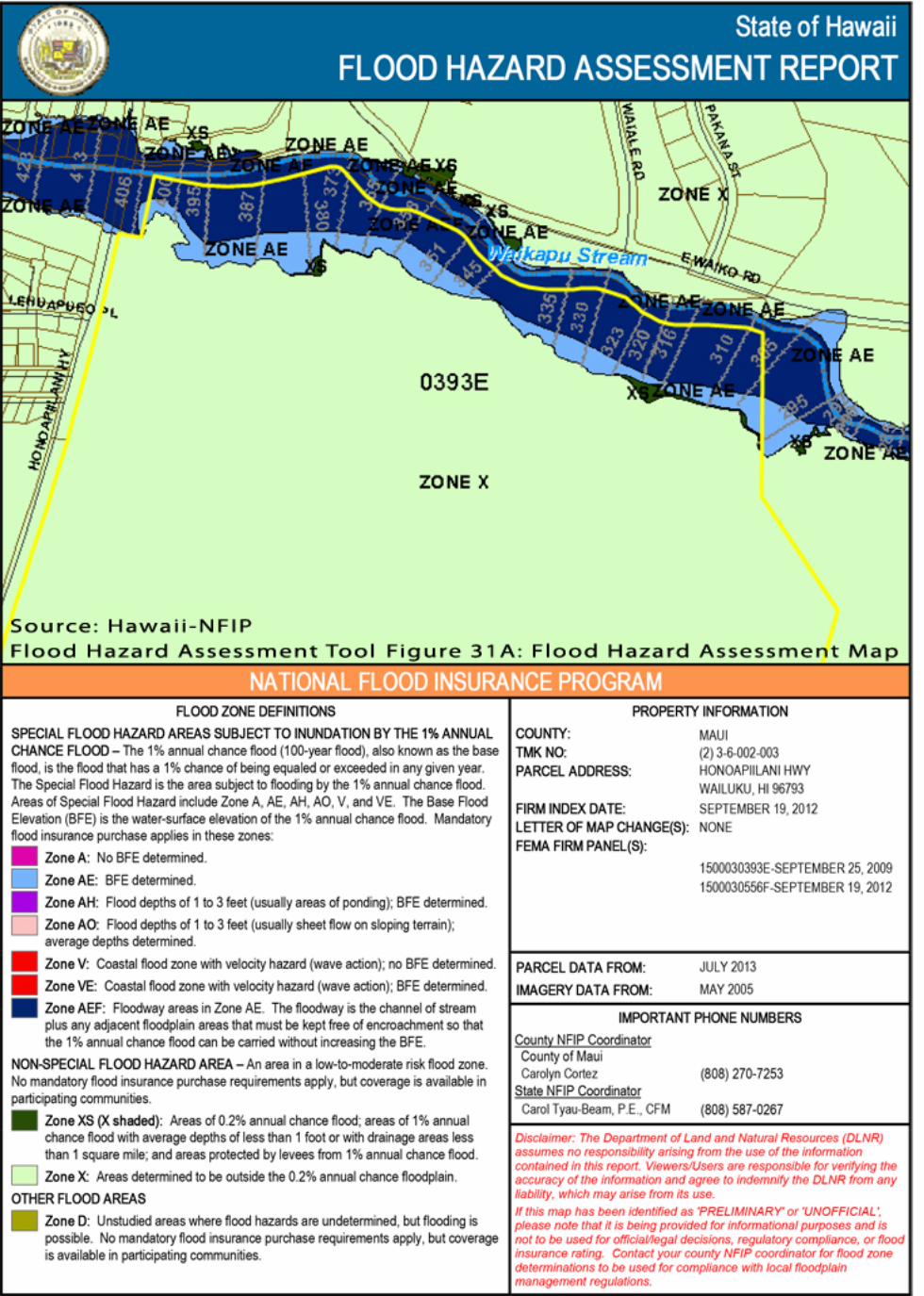
Flood hazards are primarily identified by the Flood Insurance Rate Map (FIRM) prepared by the
United States Department of Homeland Security Federal Emergency Management Agency
(FEMA), National Flood Insurance Program. Flood zone designations can also be identified by
using the Hawaiʻi National Flood Insurance Program, Flood Hazard Assessment Tool. A portion
of TMK Parcel Nos. 3-6-002:003 and 3-6-004:003, paralleling the Waikapū Stream, are located in
Zones AEF and AE and XS. Zones AEF and AE are Special Flood Hazard Areas subject to
inundation by the 1% annual chance flood. These areas have a 1% chance of being subjected to
the 100-year flood each year. Mandatory Flood Insurance must be carried within Special Flood
Hazard Areas. Zone AEF is defined as the channel of a stream plus any adjacent floodplain areas

CHAPTER 4 AFFECTED NATURAL ENVIRONMENT, POTENTIAL IMPACTS AND MITIGATION MEASSURES
WAIKAPŪ COUNTRY TOWN IV-8 DRAFT ENVIRONMENTAL IMPACT STATEMENT
that must be kept free of encroachment so that the 1% annual chance flood can be carried
without increasing the BFE. Zone AE is an area where the base flood elevation has been
determined. Zone XS is an area of Non-Special Flood Hazard Area, which is an area considered
to be of low to moderate risk. Mandatory flood insurance is not required in the Non-Special
Flood Hazard Area. Zone XS is defined as an area of 0.2% annual chance flood; areas of 1%
annual chance flood with average depths of less than 1 foot or with drainage areas less than 1
square mile; and areas protected by levees from 1% annual chance flood (See: Figure No. 31, A-
E, “Flood Hazard Assessment Maps”).
Potential Impacts and Mitigation Measures. Any structures built within the WCT site will be
constructed for protection from earthquakes and the destructive winds and torrential rainfall of
tropical hurricanes, in accordance with the Building Code adopted by the County of Maui. All
work will comply with applicable flood zone standards, such as those set forth in Chapter 19.62,
“Flood Hazard Areas”, Maui County Code.
The project area located adjacent to the Waikapū Stream, within the Special Flood Hazard Area,
is proposed to be set aside for parks, open space and agriculture. No structures will be will be
located within Zone AEF.
The WCT project site is located approximately 3.5 miles inland of Kahului Harbor and about 4
miles inland of Māʻalaea Harbor and should therefore not be impacted by tsunami or coastal
flooding. In addition, the proposed development will be designed with a drainage system,
including detention basins, to mitigate any increase in runoff that could negatively impact
neighboring properties.


CHAPTER 4 AFFECTED NATURAL ENVIRONMENT, POTENTIAL IMPACTS AND MITIGATION MEASSURES
WAIKAPŪ COUNTRY TOWN IV-14 DRAFT ENVIRONMENTAL IMPACT STATEMENT
4. Flora and Fauna
Existing Conditions. Botanical and Faunal Surveys were conducted by Robert W. Hobdy,
Environmental Consultant, in February 2013 for the 494 acres proposed for development (See:
Appendix B, “Botanical and Faunal Surveys”).
A total of 130 plant species were recorded during the survey. Seven species were found to be
common within the project area: buffelgrass (Cenchrus ciliaris), Guinea grass (Megathyrsus
maximus), sugar cane (Saccharum officinarum), smooth rattlepod (Crotalaria pallida),
cheeseweed (Malva parviflora), ′uhaloa (Waltheria indica) and Java plum (Syzygium cumini).
These species are found naturally in Hawaiʻi as well as throughout the tropics nearly worldwide
and are common.
Just 3 native species were found within the project area: ′uhaloa, koali awahia (Ipomoea indica)
and popolo (Solanum americanum). These species are found naturally in Hawaiʻi as well as
throughout the tropics nearly worldwide and are common. Four plant species found during the
survey were introduced over a thousand years ago by Polynesian voyagers: kukui (Aleurites
moluccana), niu (Cocos nucifera), hau (Talipariti tileaceum) and ′ihi′ai (Oxalis corniculata). The
remaining 123 species were non-native plants, including some useful forage grasses, but many
are considered to be agricultural or roadside weeds.
All of the mammals recorded are common non-native species of no particular concern. None of
the endangered Hawaiʻian hoary bats were detected during the survey. Birdlife is dominated by
widespread introduced species. While no protected seabirds were found on the property, the
‘ua’u and ‘a’o are known to overfly the area between the months of March and November.
Three native insects were recorded during the survey. The indigenous dragonflies, the globe
skimmer and the green darner are both widespread and common, both in Hawaiʻi and
elsewhere, and are of no particular conservation concern. The Blackburn’s sphinx moth,
however, is an endangered species and is of special concern. Just two individuals of its preferred
host plants, the tree tobacco, were found on the northern end of the sugar cane fields at the
base of a stockpiled sand pile. These two plants were carefully examined for eggs, larvae or signs
of feeding. One plant was found to have two mature eggs on separate leaves. The eggs had

CHAPTER 4 AFFECTED NATURAL ENVIRONMENT, POTENTIAL IMPACTS AND MITIGATION MEASSURES
WAIKAPŪ COUNTRY TOWN IV-15 DRAFT ENVIRONMENTAL IMPACT STATEMENT
turned brown, indicating they were ready to hatch out young larvae. Tree tobacco plants are not
native to Hawaiʻi, but fall under the protection of the Endangered Species Act (1973) during the
period of their association with the Endangered Blackburn’s sphinx moth. The occurrences of
the non-native amphibians, reptiles and mollusks are of no particular interest or concern.
Potential Impacts and Mitigation Measures. As a result of the above findings it is determined
that there is little of botanical concern and that the proposed project is not expected to have a
significant negative impact on the botanical resources in this part of Maui. No recommendations
with regard to plants are deemed appropriate or necessary.
With respect to the ‘ua’u and ‘a’o which are known to overfly the property, it is recommended
that any significant outdoor lighting be shielded to direct the light downward so that it is not
visible from above. This is because the ‘ua’u and ‘a’o are easily confused and distracted by
bright lights and often crash to the ground, where they are particularly vulnerable to being run
over by vehicles or killed by predators.
As for the presence of the two tree tobacco plants, one of which was host to two mature
Blackburn’s sphinx moth eggs, Hobdy recommended that this occurrence be reported to the
U.S. Fish and Wildlife Service so that the required protections and management actions could be
clarified.
In a December 15, 2015 e-mail to Planning Consultants Hawaiʻi LLC, the U.S. Fish and Wildlife
Service provided the following guidance to mitigate impacts to the Blackburn’s sphinx moth that
might exist on the WCT property (See Appendix L):
1. Survey protocol
Surveys for Blackburn’s sphinx moth and its potential host plants will be conducted by a
qualified individual during the wettest portion of the year (Hawaiʻi Island: January to April;
Maui North shore: November to April; rest of Maui: October to April – early surveys can be
done if there have been Kona storms), approximately four to eight weeks following a
significant rainfall event. In some cases, multiple surveys may be recommended.

CHAPTER 4 AFFECTED NATURAL ENVIRONMENT, POTENTIAL IMPACTS AND MITIGATION MEASSURES
WAIKAPŪ COUNTRY TOWN IV-16 DRAFT ENVIRONMENTAL IMPACT STATEMENT
If Nothocestrum sp. or N. glauca are detected during surveys, the plants will be visibly
marked with flagging and the following documented: 1) general larval plant density; 2)
proximity of larval plants to project sites; 3) average height of the larval plants; 4) signs of
larval feeding damage on leaves; and 5) presence of Blackburn’s sphinx moth larvae on
leaves.
2. Avoidance and minimization
N. glauca frequently occurs in disturbed areas. Blackburn’s sphinx moth adults lay eggs
on N. glauca and moth larvae feed on the leaves of the plant before they crawl from the
plant and burrow into the soil or crevices in rock where they pupate for up to a year or
longer. They are most likely to pupate within 33 ft. (10 m) of the larval host plant, although
they may transit farther over paved and hardened surfaces to find a suitable site to enter
the ground. The minimization measures below are conservative because our understanding
of the species’ resource limitations and behavior is limited. Clearing of the N. glauca would
be completed using the following safeguards to ensure the potential for direct effects to
Blackburn’s sphinx moth eggs, larvae, and pupae are minimized:
If N. glauca is less than three feet in height and no Blackburn’s sphinx moth eggs,
larvae, or signs indicating the possibility of pupating larvae (such as frass, chewed
stems or other browsing characteristics) are detected, the entire plant(s) may be
removed and the soil within 33 ft. (10 m) may be disturbed.
If N. glauca is more than three feet in height, it is possible that the signs of
Blackburn’s sphinx moth foraging have been shed and pupating larvae may be in the
ground in the area beneath the plant(s). Therefore, if there are no signs of
Blackburn’s sphinx moth on N. glauca more than three feet in height, the above-
ground portion of the plant(s) may be cut off and removed and the following
measures implemented to minimize the potential for future use of the plant by
Blackburn’s sphinx moth and potential impact to a pupae that may already be in the
soil near the plant:
Stems will be treated with herbicide or re-trimmed to prevent leaf growth
and potential use by the Blackburn’s sphinx moth.
A 33-ft (10-m) disturbance-free buffer will be established around the plant’s
location for one year. After one year, the plant roots may be removed and

CHAPTER 4 AFFECTED NATURAL ENVIRONMENT, POTENTIAL IMPACTS AND MITIGATION MEASSURES
WAIKAPŪ COUNTRY TOWN IV-17 DRAFT ENVIRONMENTAL IMPACT STATEMENT
the soil disturbed if necessary. The one-year waiting period will ensure any
larvae pupating in the soil will have pupated and emerged from the soil
prior to disturbance of the plant(s) or soil.
In accordance with the U.S. Fish and Wildlife’s guidance, a qualified biologist will be retained to
resurvey the previously identified Tree Tobacco (N. glauca) plants, and immediate area, for the
presence of Blackburn’s sphinx moth larvae. Depending upon the height of the tree, and the
presence or absence of the Blackburn’s sphinx moth, the prescribed mitigation measures
documented above will be adhered to. Based upon the guidance provided, the Applicant
understands that by implementing the necessary mitigation measures, the presence of the host
Tree Tobacco plant and Blackburn’s sphinx moth should not constrain development of the
project site.