Aeronautical Charts
40
-
Upload
volkanmidilli -
Category
Documents
-
view
502 -
download
0
Transcript of Aeronautical Charts

Content Content
• Aim of Map Reading, Aim of Map Reading,
• Definition of a Map,Definition of a Map,
• Care of Maps,Care of Maps,
• Marginal Information, andMarginal Information, and
• Conventional Sign.Conventional Sign.
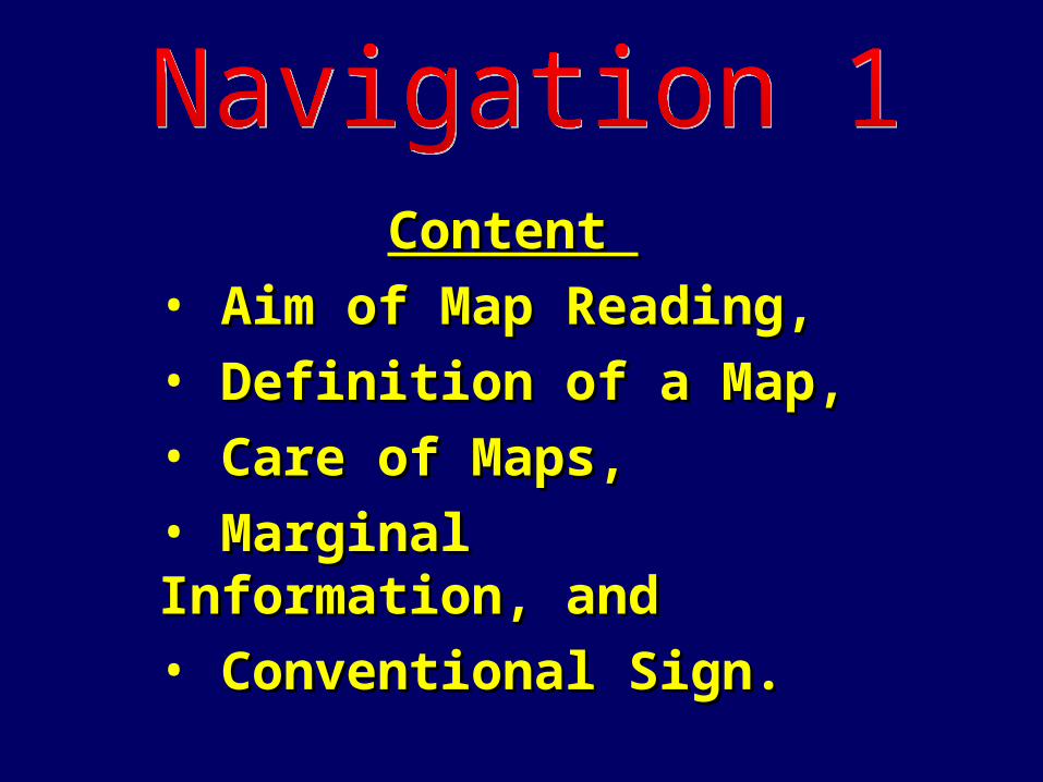
The Aims of Map Reading are to Enable a The Aims of Map Reading are to Enable a Soldier to:Soldier to:
• NavigateNavigate and recognise features on the and recognise features on the map and ground,map and ground,
• Picture Picture the Ground even though it hasn’t the Ground even though it hasn’t been seen, andbeen seen, and
• UnderstandUnderstand and Pass Information quickly. and Pass Information quickly.

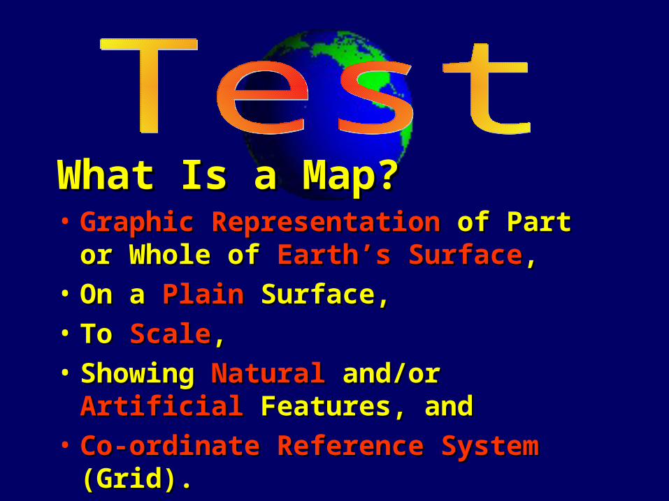
• Graphic Representationraphic Representation of Part or Whole of Part or Whole of of Earth’s SurfaceEarth’s Surface, ,
• On a On a PlainPlain Surface, Surface,
• To To ScaleScale, ,
• Showing Showing NaturalNatural and/or and/or Artificial Artificial Features, andFeatures, and
• Co-ordinate Reference SystemCo-ordinate Reference System (Grid). (Grid).

• What Are The Aims of Map Reading?What Are The Aims of Map Reading?– Navigate,Navigate,– Picture, andPicture, and– Understand/Pass InformationUnderstand/Pass Information
• What is a Map?What is a Map?– Graphic Representation of Earth’s Surface,Graphic Representation of Earth’s Surface,– Usually on a plain surface,Usually on a plain surface,– To Scale,To Scale,– Natural/Artificial Features, andNatural/Artificial Features, and– Grid System.Grid System.

Map Deterioration:Map Deterioration:• Dirt and Grime,Dirt and Grime,• Liquids,Liquids,• Unnecessary Folding/Opening, andUnnecessary Folding/Opening, and• Ink Pens/Markers, Sharp Objects.Ink Pens/Markers, Sharp Objects.

Map Protection:Map Protection:
• From ExposureFrom Exposure– Clear Contact,Clear Contact,
– Map Case,Map Case,
– Plastic Bag,Plastic Bag,
– Map Board.Map Board.

Map Protection:Map Protection:
• From WearFrom Wear– Correct Folding,Correct Folding,
– Use Pencil Lightly - No Pens ,Use Pencil Lightly - No Pens ,
– Avoid Sharp Objects,Avoid Sharp Objects,
– The Map should be left folded.The Map should be left folded.
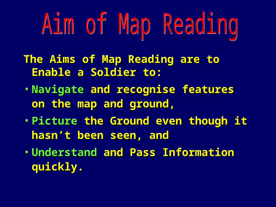
Fold In Half Top To BottomFold In Half Top To Bottom

Then Fold In Quarters Left To RightThen Fold In Quarters Left To Right

What Causes Map Deterioration?What Causes Map Deterioration?• Dirt and Grime,Dirt and Grime,• Liquids,Liquids,• Unnecessary Folding/Opening, Unnecessary Folding/Opening,
andand• Ink Pens/Markers, Sharp Ink Pens/Markers, Sharp
Objects.Objects.

How Can You Protect Your Map?How Can You Protect Your Map?• Contact, Contact, • Map Case, Map Case, • Plastic Bag, Plastic Bag, • Map Board,Map Board,• Use Pencils - Not Pens,Use Pencils - Not Pens,• Avoid Sharp Objects, andAvoid Sharp Objects, and• Correct Folding.Correct Folding.

16
21
20
19
22
2218
17
15
2214
13
12
16
21
20
19
22
2218
17
15
2214
13
12
26 27 26 292628 29 30 31
26 27 26 292628 29 30 31
LOST SPECIAL
SCALE 1: 25 00

What is it ???
16
21
20
19
22
2218
17
15
2214
13
12
16
21
20
19
22
2218
17
15
2214
13
12
26 27 26 292628 29 30 31
26 27 26 292628 29 30 31
LOST SPECIAL
SCALE 1: 25 00
What is it ???
It Is the Information LocatedAround the Edges of the MapWhich is Necessary for theCorrect Use of the Map.

Such As..
16
21
20
19
22
2218
17
15
2214
13
12
16
21
20
19
22
2218
17
15
2214
13
12
26 27 26 292628 29 30 31
26 27 26 292628 29 30 31
LOST SPECIAL
SCALE 1: 25 00
Such As..
The Title
Legend
Contour Interval
Scale

16
21
20
19
22
2218
17
15
2214
13
12
16
21
20
19
22
2218
17
15
2214
13
12
26 27 26 292628 29 30 31
26 27 26 292628 29 30 31
LOST SPECIAL
SCALE 1: 25 00
TOP RIGHT
Map Series No.Sheet No.Edition No.
SERIES R851SHEET KAPOOKA SPECIALEDITION 2 - AAS
REFER TO THIS MAP AS:

16
21
20
19
22
2218
17
15
2214
13
12
16
21
20
19
22
2218
17
15
2214
13
12
26 27 26 292628 29 30 31
26 27 26 292628 29 30 31
LOST SPECIAL
SCALE 1: 25 00
TOP CENTRE
Map Title
KAPOOKA SPECIALNEW SOUTH WALES

16
21
20
19
22
2218
17
15
2214
13
12
16
21
20
19
22
2218
17
15
2214
13
12
26 27 26 292628 29 30 31
26 27 26 292628 29 30 31
LOST SPECIAL
SCALE 1: 25 00
Map Scale
TOP LEFT
AUSTRALIAN 1 : 25 000TOPOGRAPHIC SURVEY
Map Type

16
21
20
19
22
2218
17
15
2214
13
12
16
21
20
19
22
2218
17
15
2214
13
12
26 27 26 292628 29 30 31
26 27 26 292628 29 30 31
LOST SPECIAL
SCALE 1: 25 00
Compilation Field VerificationDate,
PRODUCTION: Royal Australian Survey Corps under the direction of the Chief of the General Stafff.PRINTING: Royal Australian Survey Corps 1992.DISTRUBTION: To the Australian Defence Force by the Royal Australian Survey Corps.CONTROL: Horizonal: GPS Class B control, base lined from existing 1st and 2nd Order Stations. Vertical: GPS control heights from existing 1st and 2nd Order Levelling.AIR PHOTOGRAPHIY: Super Wide Angle flown 1991.COMPILATION: By digital photogrammetric methods in 1991.ACCURACY: Horizontal: 90% of well defined detail within + 25m of true position. Vertical: 90% of elevations within + 5m except in area of dense vegetation where thiss may not be achieved.
GRID ZONE DESIGNATION:
55H100 000 METRE
SQUARE IDENTIFICATION
EB
IGNORE the SMALLER figures ofany grid number; these are for
finding the full co-ordinates. UseONLY the LARGER figures of the
grid numbers; example:
522000
UNIVERSAL GRIG REFERENCEBEFORE GIVING A GRID REFERENCE, CIVILIAN USERS
DHOULD STATE THE NUMBER AND NAME OF THIS MAP:LOST SPECIAL
1 Read letters identifying 100 000 metre square in which the point lies:2 Locate first VERTICAL grid lines to LEFT of point and read LARGE figures labelling the line eather in the top or bottom margin, or on the line itself:3 Estimate tenths from grid line to point:4 Locate first HORIZONTAL grid line BELOW point and read LARGE figures labelling the line in eather the left or right margin, or on the line itself:5 Estimate tenths from grid line to point:SAMPLE REFERENCE:If reporting beyond 18 in any direction,prefix with Grid Zone Designation, eg: 55HEB246107
TO GIVE A STANDARD REFERENCE ONTHIS SHEET TO NEAREST 100 METRES
SAMPLE POINT: NSW6045 374
EB
24 B
10 7
EB246107
AUSPECC1O3LOST SPECIALEDITION 2 - AAS
TRUE NORTH, GRID NORTH AND MAGNETIC NORTHARE SHOWEN DIAGRAMMATICALLY FOR THE CENTREOF THIS MAP. MAGNETIC NORTH IS CORRECT FOR
1992 AND MOVES EASTERLY BY 2 MILS (0.1) INABOUT THREE YEARS.
BEARING CONVERSIONGRID BEARING TO MAGNETIC BEARING SUBTRACT:
MAGNETIC BEARING TO GRID BEARING ADD:
GN
TNMN
GRID-MAGNETICANGLE
210 MILS (11.8 )
GRIDCONVERGENCE3 MILS (0.2 )
1992 .... 210 MILS1993 .... 210 MILS1994 .... 211 MILS1995 .... 212 MILS1996 .... 212 MILS1997 .... 213 MILS1998 .... 214 MILS1999 .... 214 MILS2000 .... 215 MILS2001 .... 216 MILS
2002 .... 216 MILS2003 .... 217 MILS2004 .... 218 MILS2005 .... 218 MILS2006 .... 219 MILS2007 .... 220 MILS2008 .... 221 MILS2009 .... 221 MILS2010 .... 222 MILS2011 .... 223 MILS
BOTTOM LEFT
North Point DiagramUniversal Grid Ref and

16
21
20
19
22
2218
17
15
2214
13
12
16
21
20
19
22
2218
17
15
2214
13
12
26 27 26 292628 29 30 31
26 27 26 292628 29 30 31
LOST SPECIAL
SCALE 1: 25 00
Contour Interval,
BOTTOM CENTRE
Water Course Guide andLegend,
Scale,Climatic Graphs.
PRODUCTION: Royal Australian Survey Corps under the direction of the Chief of the General StafffDISTRUBTION: To the Australian Defence Force by the Royal Australian Survey Corps.CONTROL: Horizonal: GPS Class B control, base lined from existing 1st and 2nd Order Stations. Vertical: GPS control heights from existing 1st and 2nd Order Levelling.AIR PHOTOGRAPHIY: Super Wide Angle flown 1991.COMPILATION: By digital photogrammetric methods in 1991.ACCURACY: Horizontal: 90% of well defined detail within + 25m of true position. Vertical: 90% of elevations within + 5m except in area of dense vegetation where thiss may not be achieved.
PRODUCTION: Royal Australian Survey Corps under the direction of the Chief of the General StafffDISTRUBTION: To the Australian Defence Force by the Royal Australian Survey Corps.CONTROL: Horizonal: GPS Class B control, base lined from existing 1st and 2nd Order Stations. Vertical: GPS control heights from existing 1st and 2nd Order Levelling.AIR PHOTOGRAPHIY: Super Wide Angle flown 1991.COMPILATION: By digital photogrammetric methods in 1991.ACCURACY: Horizontal: 90% of well defined detail within + 25m of true position. Vertical: 90% of elevations within + 5m except in area of dense vegetation where thiss may not be achieved.

16
21
20
19
22
2218
17
15
2214
13
12
16
21
20
19
22
2218
17
15
2214
13
12
26 27 26 292628 29 30 31
26 27 26 292628 29 30 31
LOST SPECIAL
SCALE 1: 25 00
BOTTOM RIGHTBOTTOM RIGHT
Map Title
KAPOOKA SPECIAL
WAGGA WAGGA8327-I-N
LAKE ALBERT8327-I-N
BIG SPRINGS8327-I-N
THE ROCK8327-I-N
URANQUINTY8327-I-N
COLLINGULLIE8327-I-N
INDEX TO ADJOINING MAPS
KAPOOKA SPECIALNEW SOUTH WALES
STOCK NO. AUSPECO103
Index To Adjoining Maps

QUESTIONS?Name Four Pieces of Marginal Information?
• Title
• Edition and Series Number
• Nth Point Diagram
• Legend
• Scale
• Watercourse Guide

Definition:Definition:
• Coloured Symbols which are used to Coloured Symbols which are used to represent both natural and Artificial represent both natural and Artificial Features on a Map.Features on a Map.
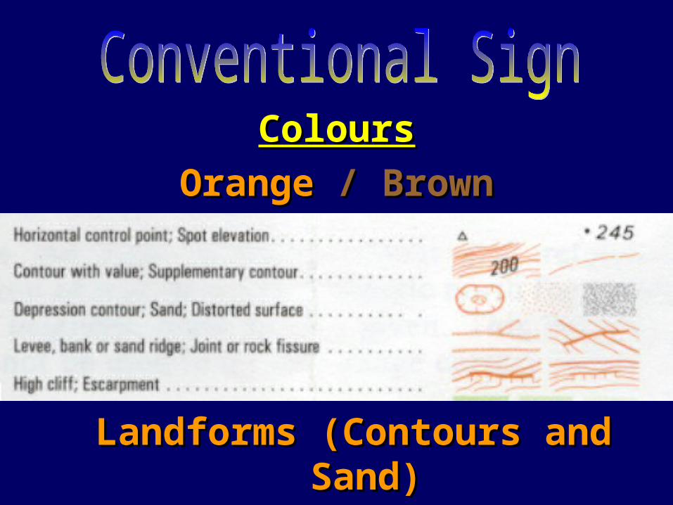
ColoursColours
OrangeOrange // BrownBrown
Landforms (Contours and Sand)Landforms (Contours and Sand)
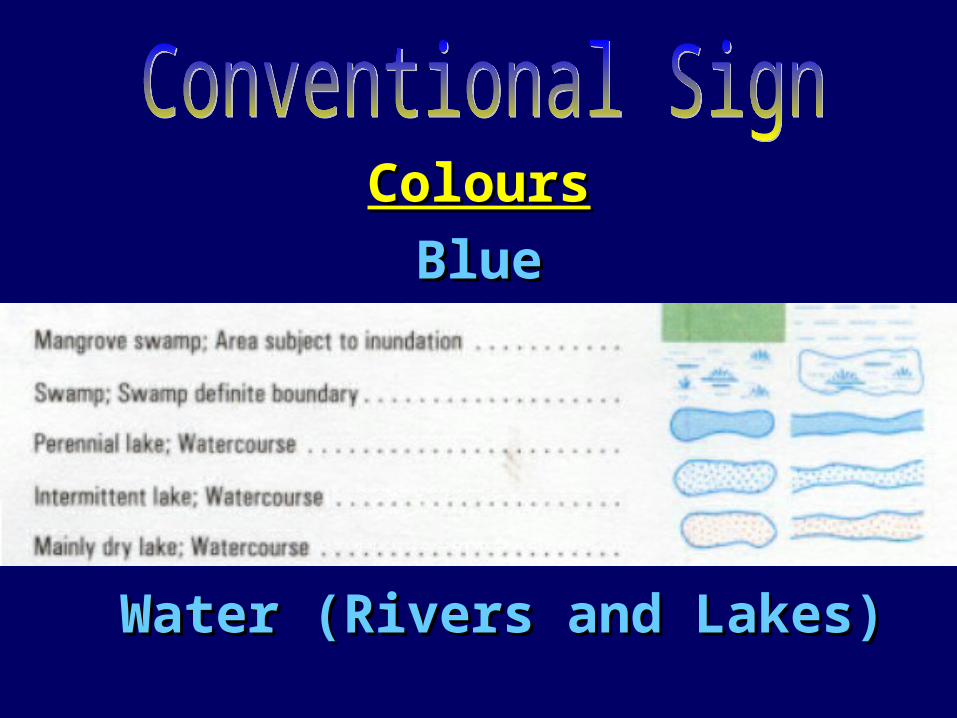
ColoursColours
BlueBlue
Water (Rivers and Lakes)Water (Rivers and Lakes)

ColoursColours
GreenGreen
Vegetation (Orchards and Forests)Vegetation (Orchards and Forests)
ColoursColours
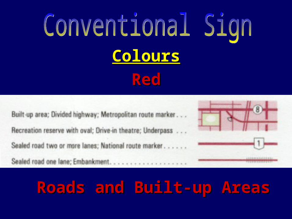
RedRed
Roads and Built-up AreasRoads and Built-up Areas

ColoursColours
BlackBlack
Artificial Features (Railways and Artificial Features (Railways and Buildings)Buildings)

ColoursColours
PurplePurple
Overprints (Tactical and Overprints (Tactical and Aeronautical Information)Aeronautical Information)

Reading Conventional SignReading Conventional SignUnsealed Road Unsealed Road

Another ExampleAnother ExampleRoad Bridge Road Bridge

QUESTIONS?What Are Conventional Signs?
• Coloured Symbols that Represent features on a Map.
Give Three of the Colours and Examples.
• Red - Built-up Areas & Roads
• Blue - Watercourses
• Green - Vegetation

QUESTIONS?What Are Conventional Signs?
• Coloured Symbols that Represent features on a Map.
Give Three of the colours and Examples.
• Black - Train Tracks & Buildings• Orange/Brown - Sand & Contours
• Purple - Tactical and Aeronautical
What Is a Map?What Is a Map?• Graphic Representationraphic Representation of Part or Whole of Part or Whole
of of Earth’s SurfaceEarth’s Surface, ,
• On a On a PlainPlain Surface, Surface,
• To To ScaleScale, ,
• Showing Showing NaturalNatural and/or and/or ArtificialArtificial Features, andFeatures, and
• Co-ordinate Reference SystemCo-ordinate Reference System (Grid). (Grid).

Three Ways Maps Deteriorate?Three Ways Maps Deteriorate?• Dirt and Grime,Dirt and Grime,• Liquids,Liquids,• Unnecessary Folding/Opening, andUnnecessary Folding/Opening, and• Ink Pens/Markers, Sharp Objects.Ink Pens/Markers, Sharp Objects.

How do you How do you Protect a Map?Protect a Map?– Clear Contact,Clear Contact,
– Map Case,Map Case,
– Plastic Bag,Plastic Bag,
– Map Board.Map Board.
– Correct Folding,Correct Folding,
– Use Pencil Lightly Use Pencil Lightly (No Pens),(No Pens),
– Avoid Sharp Avoid Sharp Objects,Objects,
– The Map should be The Map should be left folded.left folded.
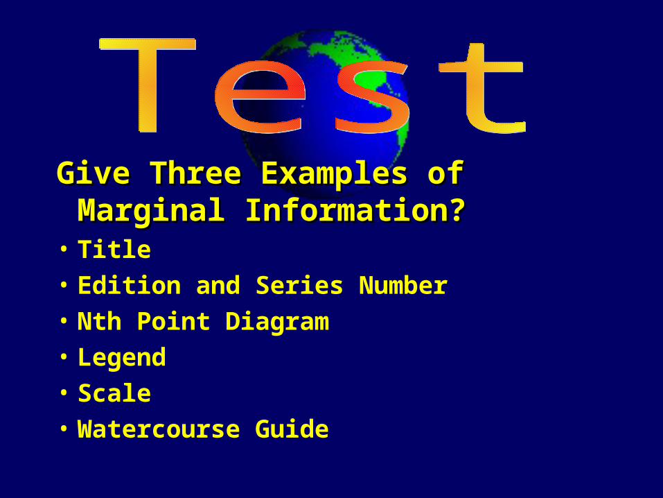
Give Three Examples of Marginal Give Three Examples of Marginal Information?Information?
• Title
• Edition and Series Number
• Nth Point Diagram
• Legend
• Scale
• Watercourse Guide

What Are Conventional Signs?What Are Conventional Signs?• Coloured Symbols that Represent
features on a Map.

• Aim of Map Reading, Aim of Map Reading,
• Definition of a Map,Definition of a Map,
• Care of Maps,Care of Maps,
• Marginal Information, andMarginal Information, and
• Conventional Sign.Conventional Sign.

• On This Subject - On This Subject - Map 2 Next WedMap 2 Next Wed
• On The Syllabus -On The Syllabus -
Dinner / BP21 Dinner / BP21