ADVANTAGES AND DISADVANTAGES OF SOME UNMANNED AERIAL ...
12
ADVANTAGES AND DISADVANTAGES OF SOME UNMANNED AERIAL VEHICLES DEPLOYED IN MARITIME SURVEILLANCE Prof. Sanja Bauk, PhD (I, II), M.Sc. Nexhat Kapidani (II) * , Luis Sousa (III), Žarko Lukšić (II), Agim Spuža (II) (I) Department of Maritime Studies, Durban University of Technology, South Africa (II) Administration for Maritime Safety and Port Management of Montenegro, Montenegro (III) Tekever, Portugal *Corresponding author Abstract: The paper discusses the advantages and disadvantages of some unmanned aerial vehicles used for maritime surveillance. As examples, the Zephyr pseudo-satellite, as well as the AR5 and the AR3 medium altitude unmanned aircraft have been presented. A high-level Strengths, Weaknesses, Opportunities, and Threats (SWOT) analysis is applied in this regard, as a tool to help assess the potential benefits of UAVs in the current maritime surveillance context. Strengths as lightness, possibility of manual launching, low energy consumption, lower price in comparison to satellites, high seeing, sensing and communication features, capacity of both line of sight (LoS) and beyond line of sight (BLoS) operations, large coverage, and durability of flight and like are highlighted. Threats such as high risk to operations due to severe weather conditions, loss of human control over the systems due to their high degree of autonomy, potential users’ reluctance to accept high-risk innovation and similar are agued, as well. In addition, weaknesses as complexity of the systems and the requirement of highly skilled personnel for these aircraft design, production, operation and maintenance, along with opportunities like lower costs, lower ecological and logistics footprints and higher efficiency are also taken into consideration. The appropriateness of these advanced aerial vehicles for monitoring and securing sea borders has been intertwined within the context. Key words: Unmanned aerial vehicles, Zephyr, AR5, AR3, maritime surveillance, SWOT. Acknowledgment: This article should contribute to the dissemination of the COMPASS2020 Project (Grant Agreement No: 833650) goals and assets with emphasis on the UAVs, which the project has been including and developing within the specific European maritime safety, security and environmental protection requirements. At the same time, research work on the article has been supported by the same Project.
Transcript of ADVANTAGES AND DISADVANTAGES OF SOME UNMANNED AERIAL ...

ADVANTAGES AND DISADVANTAGES OF SOME UNMANNED
AERIAL VEHICLES DEPLOYED IN MARITIME SURVEILLANCE
Prof. Sanja Bauk, PhD (I, II), M.Sc. Nexhat Kapidani (II)*, Luis Sousa (III),
Žarko Lukšić (II), Agim Spuža (II)
(I) Department of Maritime Studies, Durban University of Technology, South Africa
(II) Administration for Maritime Safety and Port Management of Montenegro, Montenegro
(III) Tekever, Portugal
*Corresponding author
Abstract:
The paper discusses the advantages and disadvantages of some unmanned aerial vehicles used
for maritime surveillance. As examples, the Zephyr pseudo-satellite, as well as the AR5 and the
AR3 medium altitude unmanned aircraft have been presented. A high-level Strengths,
Weaknesses, Opportunities, and Threats (SWOT) analysis is applied in this regard, as a tool to
help assess the potential benefits of UAVs in the current maritime surveillance context.
Strengths as lightness, possibility of manual launching, low energy consumption, lower price
in comparison to satellites, high seeing, sensing and communication features, capacity of both
line of sight (LoS) and beyond line of sight (BLoS) operations, large coverage, and durability
of flight and like are highlighted. Threats such as high risk to operations due to severe weather
conditions, loss of human control over the systems due to their high degree of autonomy,
potential users’ reluctance to accept high-risk innovation and similar are agued, as well. In
addition, weaknesses as complexity of the systems and the requirement of highly skilled
personnel for these aircraft design, production, operation and maintenance, along with
opportunities like lower costs, lower ecological and logistics footprints and higher efficiency
are also taken into consideration. The appropriateness of these advanced aerial vehicles for
monitoring and securing sea borders has been intertwined within the context.
Key words:
Unmanned aerial vehicles, Zephyr, AR5, AR3, maritime surveillance, SWOT.
Acknowledgment:
This article should contribute to the dissemination of the COMPASS2020 Project (Grant
Agreement No: 833650) goals and assets with emphasis on the UAVs, which the project has
been including and developing within the specific European maritime safety, security and
environmental protection requirements. At the same time, research work on the article has been
supported by the same Project.

INTRODUCTION
Unmanned aerial vehicles (UAVs) are being increasingly used for numerous purposes in both
military and civilian domains. For instance, current applications of this kind of systems include
surveillance, reconnaissance, remote sensing, target acquisition, border and maritime patrol,
infrastructure monitoring, communications support, aerial imaging, industrial inspection, as
well as emergency medical support, among others. The UAVs have capacities of sensing and
perceiving the environment, processing the sensed information, communicating, planning and
decision making, as well as acting using control algorithms and actuators [1]. Although these
systems have historically found their main technological drive and applications in the military
domain, their capabilities, alongside an increasing dissemination and consequent accessibility
of this kind of technology, have attracted the interest of the civilian markets for several
applications. As a result, the integration of UAVs in civil (non-segregated) airspace commonly
used by conventional manned aircraft has been subject of intense study in recent years, with
many initiatives currently approaching the initial implementation stages (e.g. the U-space
initiative from the European Union’s SESAR Joint Undertaking (JU) [2]). In addition to
applications such as agriculture and infrastructure monitoring, this has also paved the way to a
growing use of unmanned aircraft in support of civil security missions, with particular emphasis
in border and maritime surveillance.
Considering the context described above, this research paper has the main goal of providing an
overview of the potential impact of deploying specific types of unmanned aerial systems in
support of maritime surveillance missions and adjacent roles. As such, this paper describes the
main features of the Zephyr High Altitude Pseudo-Satellite (HAPS), as well as the AR5 and the
AR3 UAVs, which are part of a broader maritime surveillance and reconnaissance system for
monitoring and control of the European sea borders, being developed within the context of the
COMPASS2020 (Coordination Of Maritime assets for Persistent And Systemic Surveillance
2020) Project. The Strengths, Weaknesses, Opportunities, and Threats (SWOT) analysis of the
above mentioned UAVs will be conducted and presented, as well.
The question of motivation for developing and implementing the COMPASS2020 project
logically arises in this context. The project has as overarching goal the deployment of unmanned
aerial, sea surface and underwater vehicles, in operational coordination with manned oceanic
patrol vessels used by EU Maritime Authorities, to enhance current maritime border
surveillance operations, with a particular focus on the detection, monitoring and control of
irregular migration and narcotics smuggling. The project aims at setting up a solution to ensure
long range and persistent surveillance, increasing the situational awareness of maritime
authorities, as well as to upraising the cost-effectiveness, availability and reliability of related
operations. It has been conceived to help authorities handle the pressure put on European
external borders by the vast amount of irregular border crossings observed in recent years,
through improving coordinated actions supported by both manned and unmanned vehicles.
Besides struggling with irregular migrants, Europe has a problem with other incidents of the
most disperse nature, such as the long lasting issue of narcotics trafficking [3]. Consequently,
COMPASS2020 has also been conceived to help address this issue. In order to address these
two big challenges, the project proposes the development of a unified system based on open
standards that will enable the combined operation of multiple unmanned assets, manned

platforms currently used for marine surveillance and the future accommodation of other
platforms and services with minor integration efforts. The project contributes to improve the
situational awareness beyond coastal waters in different environmental conditions, ranges and
altitudes. In addition, pollution monitoring is also an increasingly important part of maritime
safety, as global commerce increases from and towards Europe, leading to a growth of vessels
and cargos crossing European sea borders. Marine traffic of high density results in a higher
probability of occurrence of pollution incidents, such as oil spills, as well as an increase in ships
sulfur emissions. Those incidents, especially the ones that occur due to severe weather
conditions such as strong winds and high sea state, can lead to high negative impacts to the
environment [4]. The capability to establish a persistent maritime surveillance infrastructure
such as proposed in the project will allow a better monitoring, control and management of these
and other threats, and allow for better decision making to ensure the safety and security of
European maritime borders.
As it is stated afore, the paper deals with unmanned aerial vehicles (UAVs) deployed within
the project. Accordingly, the rest of the paper is organized as follows: the second, third and
fourth sections comprise the description and high level analysis of the Zephyr, the AR5 and the
AR3 UAVs crucial technical features and operational capacities, respectively; the fifth section
contains the SWOT analysis of the considered UAVs; while the last section contains some
conclusion remarks along with the directions for further research work in the field.
2. THE ZEPHYR: KEY FEATURES
The Zephyr 7 has been invented in 2000 at the Flemish Institute for Technical Research in the
context of the Pegasus project. This solar airplane has been later transferred to Airbus in 2013.
The only solar-powered airplane has demonstrated a unique mission of 14 days duration at more
than 21 km flight altitude carrying a payload of 5 kg [5]. In 2014, work on Zephyr 8 began. The
Zephyr S is a new variant of Zephyr family developed upon an agreement settled between the
UK Ministry of Defense and Airbus Defense and Space. It is the first unmanned aircraft capable
to fly in the stratosphere, harnessing the sun’s rays and running on a combination of solar cells
and high-power lithium sulphur batteries (i.e., on solar-electric power), above the weather and
conventional air traffic. It is a High Altitude Pseudo-Satellite (HAPS) [6], able to fly for a month
at a time, combining the persistence of a satellite with the flexibility of an unmanned aerial
vehicle (UAV). As HAPS, the Zephyr uses high-definition electro-optical and infrared cameras
to produce real-time visuals in any lighting (Figure 1). The Zephyr unit costs around 5 million
$, while an orbital satellite costs between 50 and 400 million $ [7]. Airbus now possesses two
types of the Zephyr, designed to accommodate a variety of payloads. The production model
Zephyr S has a wingspan of 25 m and weighs less than 75 kg. It is able to carry see, sense and
connect payloads. Briefly, Zephyr S is capable to:
- See with clarity (facilitate disaster management, e.g., wildfires and oil spills);
- Sense with efficiency (trace environmental changes; monitor and secure borders);
- Connect with precision (connect securely across the globe; connect the isolated, since four
billion people in the world do not have Internet access, etc.).
Presently, the larger Zephyr T, which is under development, has a wingspan of 33 m and a
Maximum Take-off Weight (MTOW) of 140 kg [8]. The Zephyr’s main features include, but
they are not limited to:
- Flexibility - The Zephyr’s launch requirements are simple compared to traditional aviation.
It requires no runway and no airport. It is launched manually. After taking-off and reaching
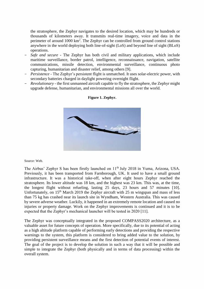
the stratosphere, the Zephyr navigates to the desired location, which may be hundreds or
thousands of kilometers away. It transmits real-time imagery, voice and data in the
perimeter of around 1000 km2. The Zephyr can be controlled from ground control stations
anywhere in the world deploying both line-of-sight (LoS) and beyond line of sight (BLoS)
operations.
- Safe and secure - The Zephyr has both civil and military applications, which include
maritime surveillance, border patrol, intelligence, reconnaissance, navigation, satellite
communications, missile detection, environmental surveillance, continuous photo
capturing, humanitarian and disaster relief, among others [9].
- Persistence - The Zephyr’s persistent flight is unmatched. It uses solar-electric power, with
secondary batteries charged in daylight powering overnight flight.
- Revolutionary - the first unmanned aircraft capable to fly the stratosphere, the Zephyr might
upgrade defense, humanitarian, and environmental missions all over the world.
Figure 1. Zephyr.
Source: Web.
The Airbus’ Zephyr S has been firstly launched on 11th July 2018 in Yuma, Arizona, USA.
Previously, it has been transported from Farnborough, UK. It used to have a small ground
infrastructure. It was a historical take-off, when after eight hours Zephyr reached the
stratosphere. Its lower altitude was 18 km, and the highest was 23 km. This was, at the time,
the longest flight without refueling, lasting 25 days, 23 hours and 57 minutes [10].
Unfortunately, on 15th March 2019 the Zephyr aircraft with 25 m wingspan and mass of less
than 75 kg has crashed near its launch site in Wyndham, Western Australia. This was caused
by severe adverse weather. Luckily, it happened in an extremely remote location and caused no
injuries or property damage. Work on the Zephyr improvements is continued and it is to be
expected that the Zephyr’s mechanical launcher will be tested in 2020 [11].
The Zephyr was conceptually integrated in the proposed COMPASS2020 architecture, as a
valuable asset for future concepts of operation. More specifically, due to its potential of acting
as a high altitude platform capable of performing early detections and providing the respective
warnings to the system, this platform is considered to bring added value to the solution, by
providing persistent surveillance means and the first detection of potential events of interest.
The goal of the project is to develop the solution in such a way that it will be possible and
simple to integrate the Zephyr (both physically and in terms of data processing) within the
overall system.

3. THE AR5: KEY FEATIRES
The AR5 Life Ray Evolution (EVO) was chosen by the European Maritime Safety Agency
(EMSA) in an international tender to be the first Unmanned Aerial System to act as a European
wide marine patroller (Figure 2). It is a medium-endurance and medium-altitude fixed wing
Unmanned Aerial System (UAS). This medium-endurance and medium-altitude fixed wing
UAS is designed for wide area land and maritime surveillance, pollution monitoring, fisheries
inspection and communication relay [12]. The AR5 has advanced on board capacities in terms
of data processing. It can simultaneously process Electro-Optical/Infra-Red (EO/IR), radar and
AIS data. Since EO/IR systems are less known in sea surveillance and navigation than radar
and AIS, they will be shortly described below [13].
The EO/IR systems are imaging systems used for military, airborne homeland security, combat,
patrol, surveillance, reconnaissance, and search and rescue programs, which include both
visible and infrared sensors. Because they span both visible and infrared wavelengths, the
EO/IR systems provide total situational awareness both day and night and in low light
conditions. Critical features of EO/IR systems are long-range imaging abilities and image
stabilization. The EO/IR sensors are usually mounted on aircraft or vehicles, used at sea, and
must be able to identify targets, track them, and assess threats from a distance and in challenging
environmental conditions. The EO/IR technology is being fit to smaller payloads, including
traditional commercial drones and reconnaissance UAVs, and allow for transmitting live video
and high-definition (HD) images back to the operator to improve their awareness and reduce
risk to ground forces.
Figure 2. AR5 EVO Unmanned Aerial Vehicle.
Source: Tekever.
The AR5 Life Ray Evolution is sub-tactical UAS ranging up to 180 kg MTOW. It allows high-
speed BLoS satellite communications. More precisely, it fully manages LoS and BLoS datalink
handover. It also provides high precision video, imagery and sensor data in real time. Its features
include, for instance, a flexible architecture, supporting multiple types of payloads and
datalinks. Moreover, this platform complies with the highest production standards as the first
European-wide UAS-based maritime surveillance system, which is International Traffic in
Arms Regulations (ITAR) free [14]. As a UAV that requires a runway for take-off and landing,
its automatic take-off and landing capabilities, as well as the fact that it can use short and

unpaved airstrips, are great advantages. The AR5 EVO has a cruise speed of 100 km/h and a
standard endurance of 16 hours (its endurance is mission and payload dependent, being able to
reach up to 20 hours). The available payload capacity is up to 50 kg, wingspan 7.3 m and length
4.0 m.
The AR5 EVO is suitable for both wide area surveillance as well as near shore and maritime
missions. Among its main applications are [15]:
- Autonomous surveillance of large maritime and land areas, with onboard multi-sensor
pattern detection;
- Use of both LoS and BLoS datalink to maximize performance and minimize operational
costs;
- Multi-mission support, including border protection, fire surveillance and infrastructure
monitoring;
- Optimized onboard and ground algorithms for oil spill detection;
- Multi-sensor fusion and specialized support to Search and Rescue (SAR) operations;
- Anti-piracy and traffic control missions;
- Support to fisheries using high precision sensors.
The AR5 EVO is equipped with a three axis multi-sensor gyro-stabilized gimbal, capable of
supporting the integration of multiple types of payloads. This includes, for example, AIS
transceiver, multiple EO/IR sensors, Emergency Position Indicating Radio Beacon (EPIRB),
maritime radar, among others. It uses the following communication packages [16;17]:
Line of Sight (LoS)
- Configurable control and non-payload communication software-defined radio datalink
between 400 MHz and 1.2 GHz;
- Configurable control and non-payload communication software-defined radio back-up
datalink between 400 MHz and 1.2 GHz;
- Configurable payload datalink between 1.2 GHz and 6 GHz.
Beyond Line of Sight (BLoS)
- Configurable control and non-payload communication datalink over commercial Satcom
service at 1.5-1.6 GHz (L-Band);
- Payload datalink over commercial Satcom service at 1.5-1.6 GHz (L-Band shared).
Within COMPASS2020, the AR5 EVO UAV plays an important role as a middle layer
platform, which is able to provide wide maritime area surveillance, complementing the
operational gap between the wider coverage but lower resolution capabilities of the Zephyr, and
the lower altitude and more localized situation monitoring provided by the AR3 UAV described
in the next section.
4. THE AR3: KEY FEATURES
The AR3 Net Ray is a ship-borne UAS designed to carry out several types of maritime and
land-based missions (Figure 3). These missions include intelligence, surveillance, target
acquisition, reconnaissance (ISTAR) actions, pollution monitoring, infrastructure surveillance,
communication support operations and like. This UAS is capable of delivering an endurance
up to 10 hours (depending on the mission), which makes it an ideal solution to carry out both
maritime and land based missions. The payload capacity is 4 kg and it includes multiple options
for EO/IR sensors, near infrared to long-wave infrared (LWIR) sensors, laser illuminators,

communication relay systems, AIS transceivers, EPIRB, etc. Therefore, it can provide real time
collection, processing and transmission of high definition video. Its communication range is up
to 80 km within Radio Line of Sight; cruise speed is 85 km/h; MTOW is 23 kg; launch is
conveyed via catapult; recovery via parachute and airbags (for land based operations) or a net
system (for maritime based, ship-borne operations). The AR3 dimensions are 3.5 m of wingspan
and a length of 1.7 m [18]. The AR3 missions include both wide area surveillance and near
shore and maritime surveillance, comprising the following:
- Autonomous surveillance of large maritime and land areas, with onboard multi-sensor
pattern detection;
- Multi-mission support, including border protection, fire surveillance and infrastructure
monitoring;
- Environmental monitoring, including heat-tracking;
- Fire prevention;
- Anti-piracy and traffic control missions;
- Support to fisheries inspection using high precision sensors;
- Long range monitoring of large infrastructures, like pipelines or aerial electricity networks;
- Support for “over the hill” or beyond radio line of sight missions, etc.
Figure 3. The AR3 Net Ray taking-off.
Source: Tekever.
The AR3 Net Ray UAV will be included in the COMPASS2020 surveillance ecosystem as an
organic asset of the oceanic patrol vessels operated by the maritime authorities. This UAV will
be operated (launched, piloted and recovered) from the vessel to provide the tactical teams with
enhanced real time information to help decision-making. The AR3 will cover a surveillance
level below the AR5, providing a more localized monitoring of events and situations of interest.
5. THE UAVs SWOT ANALYSIS
In this subsection, some indicative positive and negative factors connected with the above
presented UAVs are given. These factors are organized in the form of the SWOT analysis
(Figure 4). After the strengths and weaknesses, the authors identified the main threats and
opportunities of the considered UAVs [19].

Figure 4. The SWOT concept.
Source: Own.
Strengths:
- Lightness;
- Manual launching or reduced logistics footprint;
- Low energy consumption;
- Lower acquisition price in comparison to satellites;
- Better quality of information in comparison to satellites;
- Lower operational costs in comparison to manned aircraft used for the same mission
profiles;
- Ability to fly for more hours continuously in comparison to manned aircraft, as there is no
need for aircraft downtime for pilot rendition;
- High seeing, sensing and communication capacities;
- Capacity of both LoS and BLoS operations;
- Large coverage and durability of flight without recharging;
- High level of automation;
- Resistance to environmental disturbances;
- Possibility to be safely integrated with commercial aviation;
- Capacity to support high risk activities;
- Capacity to reach areas inaccessible for humans, etc.
Weaknesses:
- Complexity of the UAVs makes them more vulnerable;
- Requirements for highly skilled personnel for designing, creating, operating-controlling,
maintaining and upgrading the UAVs;
- Lack of law regulations at a wider scale;
- Lack of management and operational knowledge at different levels of the UAVs operation;
- Lack of common communication capacities between the UAVs and other vehicles within
integrated traffic and transportation system;
- The link between the UAVs and ground control stations;
- Maneuvering and obstacles’ avoidance algorithms are under development;
- Computer vision is also still until development, etc.
Opportunities:

- Increasing safety and security at sea and in general;
- Reduction of traffic congestion in areas with high density traffic;
- Approaching up to now inapproachable areas;
- Approaching areas of high risk for humans;
- Gathering more information on distance areas, entities, constructions, etc.;
- Lower ecological footprint;
- Developing 3D path planning with obstacle avoidance;
- Developing potentials of autonomous systems;
- Further development of artificial super-complex UAV systems, etc.
Threats:
- Collapse of the UAVs due to severe weather conditions/harsh environments;
- Negative effects of external factors as natural forces and cosmic impacts;
- Losing human control over the craft;
- Unsafe landing and recovering;
- Internal disturbances and faults in the systems as super-complex ones;
- Over-reliance on technology, i.e., UAVs in the analyzed context;
- Unauthorized malicious intrusion into the system (hacking);
- Scarcity of the cost-benefit analysis;
- High investment risks;
- The lack of readiness of entrepreneurs to support further development of UAVs;
- Uncertain revenue of investments;
- Users’ reluctance to accept high risk investments in the UAVs innovations;
- Questionable innovation acceptance success, etc.
The efficiency of the UAVs is always at the expense of their robustness. Therefore, there should
be a balance between the efficiency and robustness of these systems [20]. Besides, it is well
known from the theory of automated systems that the more complex the system, the greater the
possibility of errors and its disturbance [21]. A way to make the UAVs more reliable is to make
them layered, while the communication between layers and maintaining efficiency should be
boosted.
6. CONCLUSIONS
A review of the UAVs within the context of the COMPASS2020 project has been presented in
this article. The Zephyr, the AR5 and the AR3 UAVs have been described through highlighting
their key features. Based on the findings from secondary literature resources and experiences
from the project up to now, some strengths, weaknesses, opportunities and threats of the
considered UAVs have been identified and highlighted.
The future research in this area should provide a deeper insight of compatibility of the UAV
systems with the existing and well-established manned and unmanned craft used for the same
or similar purposes. In addition, harmonizing and rationalizing communication among all assets
involved within the considered project should be taken into more depth consideration.
There is a strong argument in favor of increasing initiatives for testing, validating and
integrating unmanned systems within current surveillance infrastructures (both land and
maritime based), as these assets can help enhance current surveillance and monitoring

capabilities of authorities in a cost-effective way. However, the so-called “blind-belief” in
technology, including the analyzed UAVs, should be interrogated. The willingness of various
stakeholders to implement and adopt these advantageous systems should be investigated, as
well, with the aim to provide the innovation implementation success in both military and civil
traffic and surveillance missions.
References:
[1] Becerra, V.M. Autonomous control of unmanned aerial vehicles. Electronics [online]. Vol.
8, Num. 4, 2019. [Date of access: 4 October 2020]. Available at:
<https://doi.org/10.3390/electronics8040452>
[2] Karpowicz J. Building a foundation to enable European-wide U-space Drone
Implementation. In: Commercial UAV news [online]. 3 April 2019. [Date of access: 20 January
2020]. Available at: https://www.commercialuavnews.com/europe/european-wide-u-space-
drone-implementation
[3] Boosting the effectiveness of the Security Union - Focus Area. In: European Comission.
Horizon 2020 : work programme 2018-2020 secure societies : protecting freedom and
security of Europe and its citizens [online]. European Commission Decision C(2020)1862 of
25 March 2020. [Date of access: 4 October 2020]. Available at:
<https://ec.europa.eu/research/participants/data/ref/h2020/wp/2018-2020/main/h2020-
wp1820-security_en.pdf>
[4] Bauk, S. et al. Autonomous marine vehicles in sea surveillance as one of the
COMPASS2020 project concerns. Journal of Physics: Conference Series [online]. Núm. 1357,
2019. [Date of access: 4 October 2020]. Available at: <https://doi.org/10.1088/1742-
6596/1357/1/012045>
[5] Gonzalo, J. et al. On the capabilities and limitations of high altitude pseudo-satellites.
Progress in Aerospace Science [online]. Vol. 89, 2018, p. 37-56. [Date of access: 4 October
2020]. Available at: <https://doi.org/10.1016/j.paerosci.2018.03.006>
[6] Kramer J. What are pseudo-satellites and what do they mean for aerospace and aviation?
[blog] In: VHR [online]. 12 October 2018. [Date of access: 24 November 2019]. Available at:
<https://blog.v-hr.com/blog/what-are-pseudo-satellites-and-what-do-they-mean-for-
aerospace-and-aviation>
[7] Thisdell, Dan. Analysis: Zephyr soars high despite Australia crash. In: Flight global
[online]. 12 April 2019. [Date of access: 24 November 2019]. Available at:
<https://www.flightglobal.com/news/articles/analysis-zephyr-soars-high-despite-australia-
crash-457412/>
[8] Zephyr : pioneering the stratosphere. In: Airbus [online]. 2019. [Date of access: 12
November 2019]. Available at: <https://www.airbus.com/defence/uav/zephyr.html>

[9] Zephyr S High-Altitude Pseudo-Satellite (HAPS). In: Airforce Technology [online]. 2019.
[Date of access: 24 November 2019]. Available at: <https://www.airforce-
technology.com/projects/zephyr-s-high-altitude-pseudo-satellite-haps/>
[10] Zephyr S turning dreams into reality on its maiden flight. In: Airbus [online]. 21 November
2018. [Date of access: 12 November 2019]. Available at:
<https://www.airbus.com/defence/uav/zephyr.html#medialist_1022949338-video-video-
all_ml_0-3>
[11] Bauk S, et al., Aerial segment of the COMPASS2020 Project: review of main
constituencies, In: The 24th International Information Technology Conference IT 2020 :
Zabljak, Montenegro : 18-22 February 2020 in Zabljak, Montenegro.
[12] Maritime surveillance, newest task for drones In: Bold Business [online]. 21 July 2017.
[Date of access: 25 November 2019]. Available at:
<https://www.boldbusiness.com/communications/drone-maritime-surveillance/>
[13] What is EO/IR? In: FLIR [online]. 28 July 2019. [Date of access: 25 November 2019].
Available at: <https://www.flir.com/discover/rd-science/what-is-eoir/>
[14] RAPSODY : Remote Airborne Platform with Satellite Oversight Dependency. In: EESA
Space Solutions [online]. 19 November 2018. [Date of access: 25 November 2019]. Available
at: <https://business.esa.int/projects/rapsody>
[15] Lord, Nate. Data protection 101 : What is ITAR Compliance? 2019 ITAR Regulations,
Fines Certifications & More. In: Digital Insider : Digital Guardian’s Blog [blog]. 15 July 2019.
[Date of access: 25 November 2019]. Available at: <https://digitalguardian.com/blog/what-
itar-compliance>
[16] Tekever AR5. In: Tekever [online]. [Date of access: 24 November 2019]. Available at:
<http://airray.tekever.com/ar5/>
[17] Tekever AR5 Life Ray Evolution Unmanned Aerial System (UAS). In : Naval Technology
[online]. Verdict Media, 2020. [Date of access: 24 November 2019]. Available at:
<https://www.naval-technology.com/projects/tekever-ar5-life-ray-evolution-uas/>
[18] Tekever AR3. In: Tekever [online]. [Date of access: 24 November 2019]. Available at:
<http://airray.tekever.com/ar3/>
[19] Alop, A. The main challenges and barriers to the successful smart shipping. TransNav :
International Journal on Marine Navigation and Safety of Sea Transportation [online]. 2019,
[Date of access: 8 September 2020]. Vol.13, No. 3, Sept. 2019, p. 521-528. Available at:
<https://doi.org/10.12716/1001.13.03.05>
[20] Chavaillaz, A.; Wastell, D.; Sauer, J. System reliability, performance and trust in adaptable
automation. Applied Ergonomics [online]. Vol. 52, 2016, p. 333-342. [Date of access: 8
September 2020]. Vol.13, No. 3, Sept. 2019, p. 521-528. Available at:
<https://doi.org/10.1016/j.apergo.2015.07.012>

[21] Andrews, E. The Sinking of Andrea Doria. In : History stories [online]. 24 July
2019.Television networks, 2020. [Date of access: 9 December 2019]. Vol.13, No. 3, Sept.
2019, p. 521-528. Available at: <https://www.history.com/news/the-sinking-of-andrea-doria>