ADVANCED VHF GROUND STATION FOR NOAA …users.utcluj.ro/~atn/papers/ATN_3_2012_1.pdf · ADVANCED...
7
Volume 53, Number 3, 2012 ACTA TECHNICA NAPOCENSIS Electronics and Telecommunications ________________________________________________________________________________ Manuscript received April 4 2012; revised July 4, 2012 1 ADVANCED VHF GROUND STATION FOR NOAA WEATHER SATELLITE APT IMAGE RECEPTION Vlad DASCAL 1 , Paul DOLEA 1 , Octavian CRISTEA 2 , Tudor PALADE 1 1 Technical University of Cluj-Napoca, Faculty of Electronics, Telecommunication and Information Technology, 26-28 Baritiu Street, Tel: +40264 401804, Fax: +40264 591340, Email: [email protected] 2 BITNET CCSS SRL, 56 Vasile Lupu Street, Cluj-Napoca, Tel: +40264441198, Email: [email protected] Abstract: This paper presents a short overview of the available LEO weather satellites transmitting APT (Automatic Picture Transmission) images. Also, this paper shows the development and setup of an advanced VHF ground station capable of receiving APT images from LEO weather satellites. This ground station will be capable of automatic tracking of selected NOAA satellites by using a steerable high gain multi-purpose VHF X-Quad Yagi antenna. The 137 MHz FM signal from NOAA satellites is received using a wideband Icom receiver and is processed using an external USB soundcard with dedicated software for APT/WEFAX image decoding. The proposed solution will provide low-cost access to APT data from NOAA POES weather satellite fleet. Tests were completed with good results and based on the experimental data, it demonstrates the technical feasibility of this improved receiving system. Keywords: Low Earth Orbit, ground station, NOAA, weather, APT I. LOOKING AT EARTH FROM SPACE The first TIROS-1 (Television Infrared Observation Satellites) weather satellite was launched in 1960 and started an era of space research of the Earth’s surface. Since then, entire fleets of earth observing satellites were launched and they become more complex and better from one generation to another [1]. Weather satellites transmit their data continuously on several frequencies, in various transmission modes and resolutions The most popular transmission modes are APT and WEFAX. With the improvement in electronics, these analog transmission systems are giving way to digital transmissions systems like LRPT/HRPT (Low/High Rate Picture Transmission) which require more complex receiving equipment. NOAA (National Oceanic and Atmospheric Administration) weather satellite fleet [2] is placed on a circular 98º inclination sun-synchronous polar orbit around the Earth at a distance of approximately 820 – 850 km. The NOAA satellites have a revolution period of 102 minutes, meaning that during 24 hours there will be 2 favorable passes of each of the NOAA satellite [3]. The main advantage in using sun-synchronous polar orbit is that the NOAA satellites are passing over the same regions at approximately the same time every day, having the same optimum solar illumination angle when taking images of the Earth. Currently active NOAA satellites [4,5] are shown in Table 1. Satellite APT frequency Status NOAA 15 137.6200 MHz FM ON NOAA 17 137.5000 MHz FM ON/OFF NOAA 18 137.9125 MHz FM ON NOAA 19 137.1000 MHz FM ON Table 1. Currently active NOAA satellites NOAA 17 is currently experiencing problems as a result of scan motor degradation and is being re-evaluated by the NOAA. Other existing LEO satellites used for weather monitoring are METEOR, RESURS, OKEAN and SICH. This Russian fleet of satellites usually have higher sun-synchronous orbit than NOAA satellites (1200 km) and have minor APT data frame differences. For some of these satellites, their status is unknown [6,7]. The trajectory of LEO satellites can be precisely determined using the Keplerian elements (updated TLE orbital data provided by NORAD). Two-Line Elements orbital data [8] describe the current orbit of a selected satellite at a given Epoch. Predictions regarding the satellite pass, from the moment it appears over the local horizon (AoS – Acquisition of Signal) until the moment it disappears behind the local horizon (LoS – Loss of Signal), can be made nowadays using dedicated satellite tracking software. Receiving weather information from meteorological FM satellites has become an interesting hobby especially for ham radio amateurs all over the world and begins to be very popular among students. The development of a low- cost weather ground station with minimum complexity will offer huge educational benefits in terms of gaining experience into LEO satellite communication field and encourages the formation of coherent space education community within technical university environments. II. AUTOMATIC PICTURE TRANSMISSION SYSTEM The Automatic Picture Transmission (APT) is an analog FM image transmission system developed for use on weather satellites (e.g. NOAA). The APT is similar with the WEFAX (weather facsimile) system [9,10] used on geostationary satellites. The system provides near real- time image and telemetry data to relatively low-cost ground stations around the world at least twice a day from
Transcript of ADVANCED VHF GROUND STATION FOR NOAA …users.utcluj.ro/~atn/papers/ATN_3_2012_1.pdf · ADVANCED...
Volume 53, Number 3, 2012 ACTA TECHNICA NAPOCENSIS
Electronics and Telecommunications
________________________________________________________________________________
Manuscript received April 4 2012; revised July 4, 2012
1
ADVANCED VHF GROUND STATION FOR NOAA WEATHER
SATELLITE APT IMAGE RECEPTION
Vlad DASCAL
1, Paul DOLEA
1, Octavian CRISTEA
2, Tudor PALADE
1
1Technical University of Cluj-Napoca, Faculty of Electronics, Telecommunication and Information Technology,
26-28 Baritiu Street, Tel: +40264 401804, Fax: +40264 591340, Email: [email protected] 2BITNET CCSS SRL, 56 Vasile Lupu Street, Cluj-Napoca, Tel: +40264441198, Email: [email protected]
Abstract: This paper presents a short overview of the available LEO weather satellites transmitting APT (Automatic Picture Transmission) images. Also, this paper shows the development and setup of an advanced VHF ground station capable of receiving APT images from LEO weather satellites. This ground station will be capable of automatic tracking of selected NOAA satellites by using a steerable high gain multi-purpose VHF X-Quad Yagi antenna. The 137 MHz FM signal from NOAA satellites is received using a wideband Icom receiver and is processed using an external USB soundcard with dedicated software for APT/WEFAX image decoding. The proposed solution will provide low-cost access to APT data from NOAA POES weather satellite fleet. Tests were completed with good results and based on the experimental data, it demonstrates the technical feasibility of this improved receiving system. Keywords: Low Earth Orbit, ground station, NOAA, weather, APT
I. LOOKING AT EARTH FROM SPACE The first TIROS-1 (Television Infrared Observation Satellites) weather satellite was launched in 1960 and started an era of space research of the Earth’s surface. Since then, entire fleets of earth observing satellites were launched and they become more complex and better from one generation to another [1]. Weather satellites transmit their data continuously on several frequencies, in various transmission modes and resolutions The most popular transmission modes are APT and WEFAX. With the improvement in electronics, these analog transmission systems are giving way to digital transmissions systems like LRPT/HRPT (Low/High Rate Picture Transmission) which require more complex receiving equipment. NOAA (National Oceanic and Atmospheric Administration) weather satellite fleet [2] is placed on a circular 98º inclination sun-synchronous polar orbit around the Earth at a distance of approximately 820 – 850 km. The NOAA satellites have a revolution period of 102 minutes, meaning that during 24 hours there will be 2 favorable passes of each of the NOAA satellite [3]. The main advantage in using sun-synchronous polar orbit is that the NOAA satellites are passing over the same regions at approximately the same time every day, having the same optimum solar illumination angle when taking images of the Earth. Currently active NOAA satellites [4,5] are shown in Table 1.
Satellite APT frequency Status NOAA 15 137.6200 MHz FM ON NOAA 17 137.5000 MHz FM ON/OFF NOAA 18 137.9125 MHz FM ON NOAA 19 137.1000 MHz FM ON
Table 1. Currently active NOAA satellites NOAA 17 is currently experiencing problems as a result
of scan motor degradation and is being re-evaluated by the NOAA. Other existing LEO satellites used for weather monitoring are METEOR, RESURS, OKEAN and SICH. This Russian fleet of satellites usually have higher sun-synchronous orbit than NOAA satellites (1200 km) and have minor APT data frame differences. For some of these satellites, their status is unknown [6,7]. The trajectory of LEO satellites can be precisely determined using the Keplerian elements (updated TLE orbital data provided by NORAD). Two-Line Elements orbital data [8] describe the current orbit of a selected satellite at a given Epoch. Predictions regarding the satellite pass, from the moment it appears over the local horizon (AoS – Acquisition of Signal) until the moment it disappears behind the local horizon (LoS – Loss of Signal), can be made nowadays using dedicated satellite tracking software. Receiving weather information from meteorological FM satellites has become an interesting hobby especially for ham radio amateurs all over the world and begins to be very popular among students. The development of a low-cost weather ground station with minimum complexity will offer huge educational benefits in terms of gaining experience into LEO satellite communication field and encourages the formation of coherent space education community within technical university environments.
II. AUTOMATIC PICTURE TRANSMISSION SYSTEM
The Automatic Picture Transmission (APT) is an analog FM image transmission system developed for use on weather satellites (e.g. NOAA). The APT is similar with the WEFAX (weather facsimile) system [9,10] used on geostationary satellites. The system provides near real-time image and telemetry data to relatively low-cost ground stations around the world at least twice a day from
Volume 53, Number 3, 2012 ACTA TECHNICA NAPOCENSIS
Electronics and Telecommunications
________________________________________________________________________________
2
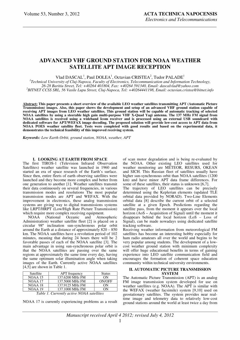
each satellite of the NOAA fleet, as it passes nearly overhead. On NOAA POES (Polar Operational Environmental Satellites) system satellites, the broadcast transmission is composed of two image channels (Video A/B) which are 4km/pixel 8-bit images derived from two channels of the AVHRR (Advanced Very High Resolution Radiometer) sensor [11]. Prior to being broadcast, the images are corrected for a constant geometric resolution, as such the images are almost free of distortion caused by the curve of the Earth. The first image is typically from a long-wave IR sensor (10.6 um), the second one switching between near-visible (0.86um) and mid-wave (3.75 um) infrared sensors, depending on weather the Earth is illuminated by the sunlight. NOAA administration can configure the satellite to transmit any two of the AVHRR image channels. Since each channel of the AVHRR sensor is sensitive to only one wavelength of light, each of the two images is luminance only, also known as grayscale. As a consequence, the warmer regions are represented by darker shades and colder regions are brighter. The signal itself is a 256-level amplitude modulated 2.4 kHz subcarrier, which is then modulated onto a 137 MHz-band RF carrier. The maximum subcarrier modulation is 87% for white and 5% for black. On NOAA POES satellites, the signal is transmitted with an EIRP of approximately 40dBm (10W) and with a RF bandwidth of 34 kHz. The APT frame format is presented in Figure 1.
The two image channels, telemetry and information data are transmitted as a horizontal scan line. A complete line is 2800 pixel long, from which 1818 pixels are used for the two images, the rest of the pixels are used for telemetry and synchronization. Lines are transmitted at a rate of 2 lines per second, which means a baud of 4160. The synchronization information is transmitted at the start of each video channel, allowing the WXtoIMG software to align its sampling with the baud rate of the signal. The markers are four line alternating black/white lines which are repeated every 60 seconds (120 lines).
The telemetry information is composed of 16 blocks (each 8 lines long), which are used as reference values to decode the image channels. The first 8 blocks (wedges) have different gradually intensity. The rest of the blocks encode a calibration value for the sensor. The blocks identifies which sensor channel was used for the preceding image channel by matching the intensity of one of the wedges one through six. The APT system from Russian METEOR satellites [7] is compatible, however slightly different from that of NOAA satellites. Modulation is similar, but pictures contain only one image of higher resolution. Edges of lines contain sets of phasing lines (alternately black and white). The images in the infrared spectrum do not contain grayscale components. Pictures from METEOR use inverse scale, where warm seas are white and cold cloud formations are black.
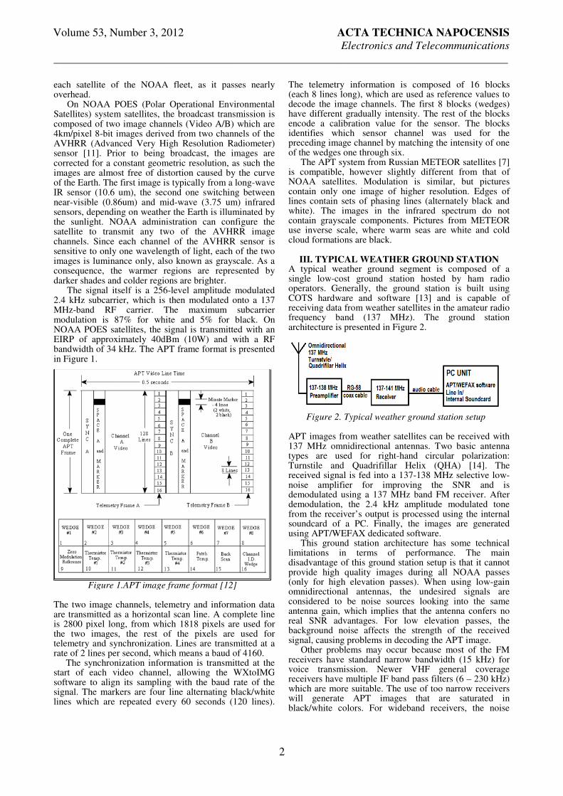
III. TYPICAL WEATHER GROUND STATION A typical weather ground segment is composed of a single low-cost ground station hosted by ham radio operators. Generally, the ground station is built using COTS hardware and software [13] and is capable of receiving data from weather satellites in the amateur radio frequency band (137 MHz). The ground station architecture is presented in Figure 2.
APT images from weather satellites can be received with 137 MHz omnidirectional antennas. Two basic antenna types are used for right-hand circular polarization: Turnstile and Quadrifillar Helix (QHA) [14]. The received signal is fed into a 137-138 MHz selective low-noise amplifier for improving the SNR and is demodulated using a 137 MHz band FM receiver. After demodulation, the 2.4 kHz amplitude modulated tone from the receiver’s output is processed using the internal soundcard of a PC. Finally, the images are generated using APT/WEFAX dedicated software. This ground station architecture has some technical limitations in terms of performance. The main disadvantage of this ground station setup is that it cannot provide high quality images during all NOAA passes (only for high elevation passes). When using low-gain omnidirectional antennas, the undesired signals are considered to be noise sources looking into the same antenna gain, which implies that the antenna confers no real SNR advantages. For low elevation passes, the background noise affects the strength of the received signal, causing problems in decoding the APT image. Other problems may occur because most of the FM receivers have standard narrow bandwidth (15 kHz) for voice transmission. Newer VHF general coverage receivers have multiple IF band pass filters (6 – 230 kHz) which are more suitable. The use of too narrow receivers will generate APT images that are saturated in black/white colors. For wideband receivers, the noise
Figure 1.APT image frame format [12]
Figure 2. Typical weather ground station setup
Volume 53, Number 3, 2012 ACTA TECHNICA NAPOCENSIS
Electronics and Telecommunications
________________________________________________________________________________
3
floor will be too high to acquire quality APT images. Also, internal soundcards are susceptible to EMI/RF noise generated by the PC and may cause supplementary problems in decoding APT images.
III. GROUND STATION HARDWARE IMPLEMENTATION
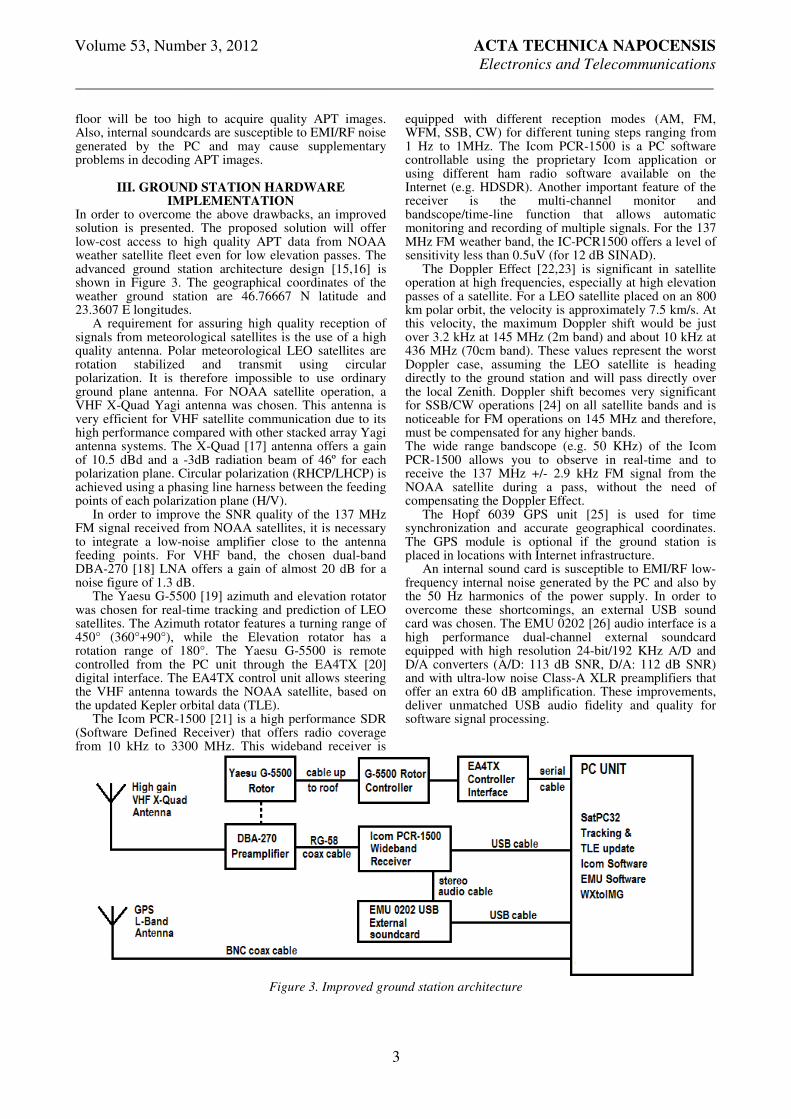
In order to overcome the above drawbacks, an improved solution is presented. The proposed solution will offer low-cost access to high quality APT data from NOAA weather satellite fleet even for low elevation passes. The advanced ground station architecture design [15,16] is shown in Figure 3. The geographical coordinates of the weather ground station are 46.76667 N latitude and 23.3607 E longitudes. A requirement for assuring high quality reception of signals from meteorological satellites is the use of a high quality antenna. Polar meteorological LEO satellites are rotation stabilized and transmit using circular polarization. It is therefore impossible to use ordinary ground plane antenna. For NOAA satellite operation, a VHF X-Quad Yagi antenna was chosen. This antenna is very efficient for VHF satellite communication due to its high performance compared with other stacked array Yagi antenna systems. The X-Quad [17] antenna offers a gain of 10.5 dBd and a -3dB radiation beam of 46º for each polarization plane. Circular polarization (RHCP/LHCP) is achieved using a phasing line harness between the feeding points of each polarization plane (H/V). In order to improve the SNR quality of the 137 MHz FM signal received from NOAA satellites, it is necessary to integrate a low-noise amplifier close to the antenna feeding points. For VHF band, the chosen dual-band DBA-270 [18] LNA offers a gain of almost 20 dB for a noise figure of 1.3 dB. The Yaesu G-5500 [19] azimuth and elevation rotator was chosen for real-time tracking and prediction of LEO satellites. The Azimuth rotator features a turning range of 450° (360°+90°), while the Elevation rotator has a rotation range of 180°. The Yaesu G-5500 is remote controlled from the PC unit through the EA4TX [20] digital interface. The EA4TX control unit allows steering the VHF antenna towards the NOAA satellite, based on the updated Kepler orbital data (TLE). The Icom PCR-1500 [21] is a high performance SDR (Software Defined Receiver) that offers radio coverage from 10 kHz to 3300 MHz. This wideband receiver is
equipped with different reception modes (AM, FM, WFM, SSB, CW) for different tuning steps ranging from 1 Hz to 1MHz. The Icom PCR-1500 is a PC software controllable using the proprietary Icom application or using different ham radio software available on the Internet (e.g. HDSDR). Another important feature of the receiver is the multi-channel monitor and bandscope/time-line function that allows automatic monitoring and recording of multiple signals. For the 137 MHz FM weather band, the IC-PCR1500 offers a level of sensitivity less than 0.5uV (for 12 dB SINAD). The Doppler Effect [22,23] is significant in satellite operation at high frequencies, especially at high elevation passes of a satellite. For a LEO satellite placed on an 800 km polar orbit, the velocity is approximately 7.5 km/s. At this velocity, the maximum Doppler shift would be just over 3.2 kHz at 145 MHz (2m band) and about 10 kHz at 436 MHz (70cm band). These values represent the worst Doppler case, assuming the LEO satellite is heading directly to the ground station and will pass directly over the local Zenith. Doppler shift becomes very significant for SSB/CW operations [24] on all satellite bands and is noticeable for FM operations on 145 MHz and therefore, must be compensated for any higher bands. The wide range bandscope (e.g. 50 KHz) of the Icom PCR-1500 allows you to observe in real-time and to receive the 137 MHz +/- 2.9 kHz FM signal from the NOAA satellite during a pass, without the need of compensating the Doppler Effect. The Hopf 6039 GPS unit [25] is used for time synchronization and accurate geographical coordinates. The GPS module is optional if the ground station is placed in locations with Internet infrastructure. An internal sound card is susceptible to EMI/RF low-frequency internal noise generated by the PC and also by the 50 Hz harmonics of the power supply. In order to overcome these shortcomings, an external USB sound card was chosen. The EMU 0202 [26] audio interface is a high performance dual-channel external soundcard equipped with high resolution 24-bit/192 KHz A/D and D/A converters (A/D: 113 dB SNR, D/A: 112 dB SNR) and with ultra-low noise Class-A XLR preamplifiers that offer an extra 60 dB amplification. These improvements, deliver unmatched USB audio fidelity and quality for software signal processing.
Figure 3. Improved ground station architecture

Volume 53, Number 3, 2012 ACTA TECHNICA NAPOCENSIS
Electronics and Telecommunications
________________________________________________________________________________
4
The hardware implementation of the weather ground station is presented in Figure 4.
The ground station will be equipped with dedicated software for tracking and decoding APT images from NOAA polar satellites. The popular SatPC32 [27] satellite tracking software was chosen for its extended driver support for the chosen COTS hardware. Based on accurate time reference, geographical coordinates and the Kepler orbital data, SatPC32 makes real-time predictions of multiple weather satellites at any given moment. During a pass, the SatPC32 application will automatically steer the Yaesu rotator antenna system towards the NOAA LEO satellite. WXtoIMG [28] is a fully automated satellite recording and decoding software. The application supports both APT transmission from polar orbiting satellites and WEFAX transmission from geostationary satellites. It uses the telemetry data from NOAA APT images for accurate calibration of the images, correcting non-linearities in the signal strength and making adjustments for gain changes over a satellite pass. The SPECTRAN [29] application is a real-time spectral analysis and filtering application for audio signals using the PC sound card. The application is used to analyze and decode the 2.4 kHz amplitude modulated subcarrier received from the analog output of the Icom PCR-1500 receiver. The ground station is also capable of receiving WEFAX images from GOES/METEOSAT [30] geostationary satellites with minor changes. The 1691 MHz FM signal can be received using a 90 cm prime focus antenna equipped with a 1.7 GHz LHCP helix feed horn.
IV. EXPERIMENTAL RESULTS The experimental tests focused on the reception and decoding of APT images from NOAA satellite fleet. On March 2
nd 2012, the NOAA 18 weather satellite was
tracked and monitored during a 43º elevation within the radio range of observing point. A “northbound 43 W” description of NOAA-18 indicate that the satellite is traveling towards the North with azimuth values ranging from 180º to 330º. The maximum elevation for this pass was 43º and the satellite was traveling at the West in respective with the ground station (at the time of maximum elevation). See Figure 5 for
further information.
The AoS (Acquisition of Signal) started at 14:55:10 UTC+2 and the LoS (Loss of Signal) ended at 15:10:40 UTC+2, providing a 15 minutes window to receive the data. The APT images are received in real-time during the pass over the ground station. The NOAA 18 had a maximum of 43º elevation at TCA (Time of Closest Approach) 15:02:50 UTC+2, meaning that, for this pass, the minimum range between NOAA 18 and ground station was only 1150 km. Figure 6 shows computed data information regarding the elevation and range over the 15 minutes window.
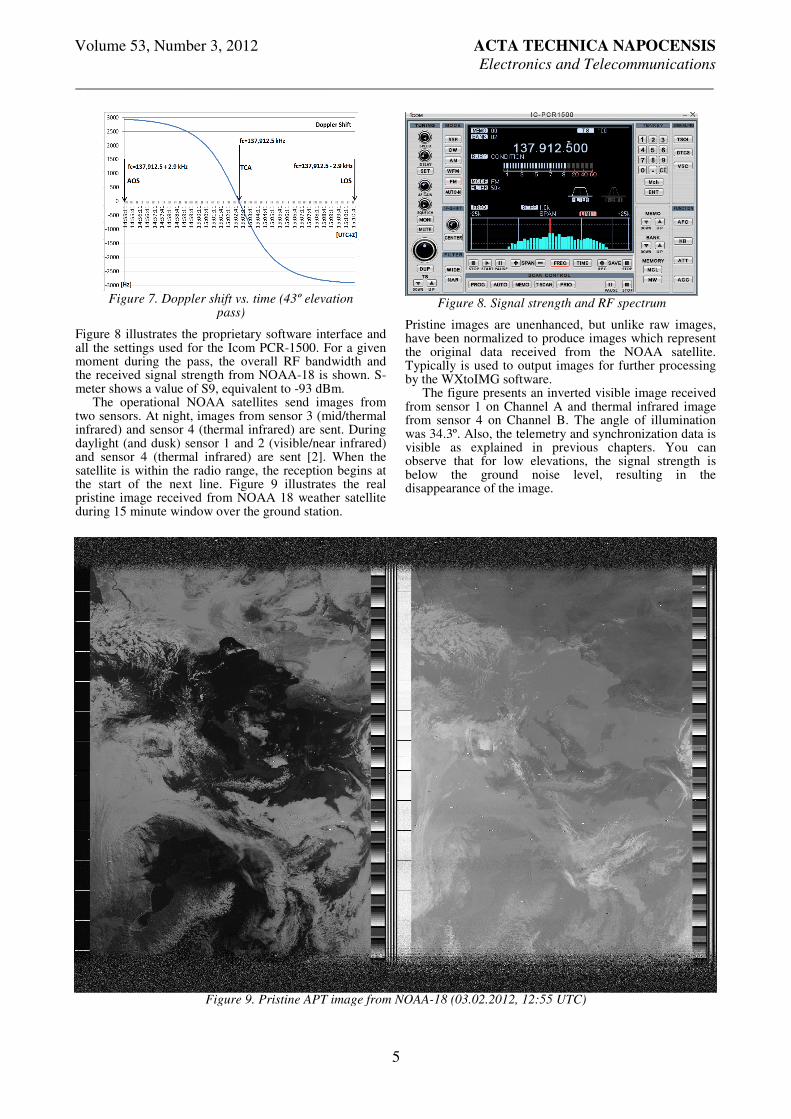
Doppler shift data was computed using dedicated tracking software. Figure 7 presents the Doppler shift of NOAA-18 FM carrier during the 43º elevation pass. The nominal carrier frequency of NOAA 18 is 137.9125 MHz. During the 15 minutes window, the Doppler shift variation is significant around the middle of the pass (at TCA) and has a fairly linear variation at low elevations. Notice that, Doppler shift starts positive (+2.9 kHz) early in the pass (when the satellite approaches), and ends up at the maximum negative value (-2.9 kHz) at the end of the pass. The magnitude of the Doppler shift for NOAA-18 is a maximum of 2.9 kHz, which is still in the pass band of the Icom PCR-1500 filters and does not cause visible distortion of final image.
Figure 4. Indoor equipments of the ground
station
Figure 5. Azimuth and Elevation characterization of the NOAA-18 pass
Figure 6. Elevation and range during NOAA-18
pass
Volume 53, Number 3, 2012 ACTA TECHNICA NAPOCENSIS
Electronics and Telecommunications
________________________________________________________________________________
5
Figure 8 illustrates the proprietary software interface and all the settings used for the Icom PCR-1500. For a given moment during the pass, the overall RF bandwidth and the received signal strength from NOAA-18 is shown. S-meter shows a value of S9, equivalent to -93 dBm. The operational NOAA satellites send images from two sensors. At night, images from sensor 3 (mid/thermal infrared) and sensor 4 (thermal infrared) are sent. During daylight (and dusk) sensor 1 and 2 (visible/near infrared) and sensor 4 (thermal infrared) are sent [2]. When the satellite is within the radio range, the reception begins at the start of the next line. Figure 9 illustrates the real pristine image received from NOAA 18 weather satellite during 15 minute window over the ground station.
Pristine images are unenhanced, but unlike raw images, have been normalized to produce images which represent the original data received from the NOAA satellite. Typically is used to output images for further processing by the WXtoIMG software. The figure presents an inverted visible image received from sensor 1 on Channel A and thermal infrared image from sensor 4 on Channel B. The angle of illumination was 34.3º. Also, the telemetry and synchronization data is visible as explained in previous chapters. You can observe that for low elevations, the signal strength is below the ground noise level, resulting in the disappearance of the image.
Figure 7. Doppler shift vs. time (43º elevation
pass)
Figure 8. Signal strength and RF spectrum
Figure 9. Pristine APT image from NOAA-18 (03.02.2012, 12:55 UTC)
Volume 53, Number 3, 2012 ACTA TECHNICA NAPOCENSIS
Electronics and Telecommunications
________________________________________________________________________________
6
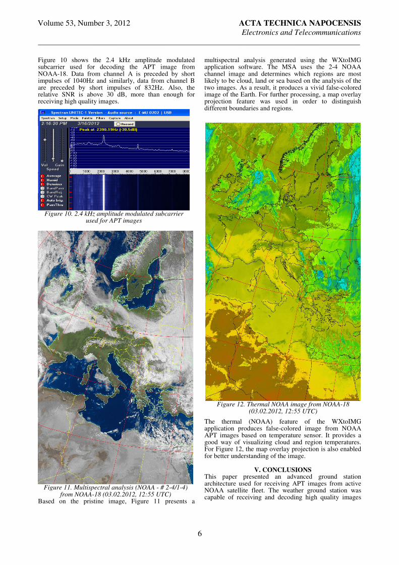
Figure 10 shows the 2.4 kHz amplitude modulated subcarrier used for decoding the APT image from NOAA-18. Data from channel A is preceded by short impulses of 1040Hz and similarly, data from channel B are preceded by short impulses of 832Hz. Also, the relative SNR is above 30 dB, more than enough for receiving high quality images.
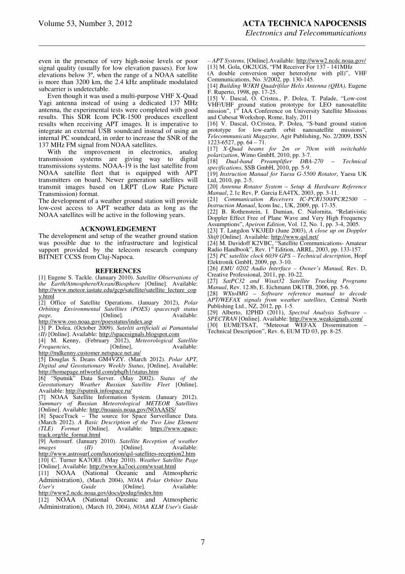
Based on the pristine image, Figure 11 presents a
multispectral analysis generated using the WXtoIMG application software. The MSA uses the 2-4 NOAA channel image and determines which regions are most likely to be cloud, land or sea based on the analysis of the two images. As a result, it produces a vivid false-colored image of the Earth. For further processing, a map overlay projection feature was used in order to distinguish different boundaries and regions.
The thermal (NOAA) feature of the WXtoIMG application produces false-colored image from NOAA APT images based on temperature sensor. It provides a good way of visualizing cloud and region temperatures. For Figure 12, the map overlay projection is also enabled for better understanding of the image.
V. CONCLUSIONS This paper presented an advanced ground station architecture used for receiving APT images from active NOAA satellite fleet. The weather ground station was capable of receiving and decoding high quality images
Figure 12. Thermal NOAA image from NOAA-18
(03.02.2012, 12:55 UTC)
Figure 10. 2.4 kHz amplitude modulated subcarrier
used for APT images
Figure 11. Multispectral analysis (NOAA - # 2-4/1-4)
from NOAA-18 (03.02.2012, 12:55 UTC)
Volume 53, Number 3, 2012 ACTA TECHNICA NAPOCENSIS
Electronics and Telecommunications
________________________________________________________________________________
7
even in the presence of very high-noise levels or poor signal quality (usually for low elevation passes). For low elevations below 3º, when the range of a NOAA satellite is more than 3200 km, the 2.4 kHz amplitude modulated subcarrier is undetectable. Even though it was used a multi-purpose VHF X-Quad Yagi antenna instead of using a dedicated 137 MHz antenna, the experimental tests were completed with good results. This SDR Icom PCR-1500 produces excellent results when receiving APT images. It is imperative to integrate an external USB soundcard instead of using an internal PC soundcard, in order to increase the SNR of the 137 MHz FM signal from NOAA satellites. With the improvement in electronics, analog transmission systems are giving way to digital transmissions systems. NOAA-19 is the last satellite from NOAA satellite fleet that is equipped with APT transmitters on board. Newer generation satellites will transmit images based on LRPT (Low Rate Picture Transmission) format. The development of a weather ground station will provide low-cost access to APT weather data as long as the NOAA satellites will be active in the following years.
ACKNOWLEDGEMENT The development and setup of the weather ground station was possible due to the infrastructure and logistical support provided by the telecom research company BITNET CCSS from Cluj-Napoca.
REFERENCES [1] Eugene S. Tackle. (January 2010). Satellite Observations of the Earth/Atmosphere/Ocean/Biosphere [Online]. Available: http://www.meteor.iastate.edu/gcp/satellite/satellite_lecture_copy.html [2] Office of Satellite Operations. (January 2012), Polar Orbiting Environmental Satellites (POES) spacecraft status page, [Online]. Available: http://www.oso.noaa.gov/poesstatus/index.asp [3] P. Dolea. (October 2009). Sateliti artificiali ai Pamantului (II) [Online]. Available: http://spacesignals.blogspot.com [4] M. Kenny, (February 2012), Meteorological Satellite Frequencies, [Online], Available: http://mdkenny.customer.netspace.net.au/ [5] Douglas S. Deans GM4VZY. (March 2012). Polar APT, Digital and Geostationary Weekly Status, [Online], Available: http://homepage.ntlworld.com/phqfh1/status.htm [6] “Sputnik” Data Server. (May 2002). Status of the Geostationary Weather Russian Satellite Fleet [Online]. Available: http://sputnik.infospace.ru/ [7] NOAA Satellite Information System. (January 2012). Summary of Russian Meteorological METEOR Satellites [Online]. Available: http://noaasis.noaa.gov/NOAASIS/ [8] SpaceTrack – The source for Space Surveillance Data. (March 2012). A Basic Description of the Two Line Element (TLE) Format [Online]. Available: https://www.space-track.org/tle_format.html [9] Astrosurf. (January 2010). Satellite Reception of weather images (II) [Online]. Available: http://www.astrosurf.com/luxorion/qsl-satellites-reception2.htm [10] C. Turner KA7OEI. (May 2010). Weather Satellite Page [Online]. Available: http://www.ka7oei.com/wxsat.html [11] NOAA (National Oceanic and Atmospheric Administration), (March 2004), NOAA Polar Orbiter Data User's Guide [Online]. Available: http://www2.ncdc.noaa.gov/docs/podug/index.htm [12] NOAA (National Oceanic and Atmospheric Administration), (March 10, 2004), NOAA KLM User's Guide
– APT Systems, [Online].Available: http://www2.ncdc.noaa.gov/ [13] M. Gola, OK2UGS, “FM Receiver For 137 - 141MHz (A double conversion super heterodyne with pll)”, VHF Communications, No. 3/2002, pp. 130-145. [14] Building W3KH Quadrifilar Helix Antenna (QHA), Eugene F. Ruperto, 1998, pp. 17-25. [15] V. Dascal, O. Cristea., P. Dolea, T. Palade, “Low-cost VHF/UHF ground station prototype for LEO nanosatellite mission”, 1st IAA Conference on University Satellite Missions and Cubesat Workshop, Rome, Italy, 2011 [16] V. Dascal, O.Cristea, P. Dolea, “S-band ground station prototype for low-earth orbit nanosatellite missions”, Telecommunicatii Magazine, Agir Publishing, No. 2/2009, ISSN 1223-6527, pp. 64 – 71. [17] X-Quad beams for 2m or 70cm with switchable polarization, Wimo GmbH, 2010, pp. 3-7. [18] Dual-band Preamplifier DBA-270 – Technical specifications, SSB GmbH, 2010, pp. 5-9. [19] Instruction Manual for Yaesu G-5500 Rotator, Yaesu UK Ltd, 2010, pp. 2-5. [20] Antenna Rotator System – Setup & Hardware Reference Manual, 2.1c Rev, P. Garcia EA4TX, 2003, pp. 3-11. [21] Communication Receivers IC-PCR1500/PCR2500 – Instruction Manual, Icom Inc., UK, 2009, pp. 17-35. [22] B. Rothenstein, I. Damian, C. Nafornita, “Relativistic Doppler Effect Free of Plane Wave and Very High Frequency Assumptions”, Apeiron Edition, Vol. 12, No. 1, pp. 3-4, 2005. [23] T. Langdon VK3JED (June 2003), A close up on Doppler Shift [Online]. Available: http://www.qsl.net/ [24] M. Davidoff K2VBC, “Satellite Communications- Amateur Radio Handbook”, Rev. 1st Edition, ARRL, 2003, pp. 133-157. [25] PC satellite clock 6039 GPS – Technical description, Hopf Elektronik GmbH, 2009, pp. 3-10. [26] EMU 0202 Audio Interface – Owner’s Manual, Rev. D, Creative Professional, 2011, pp. 10-22. [27] SatPC32 and Wisat32 Satellite Tracking Programs Manual, Rev. 12.8b, E. Eichmann DK1TB, 2006, pp. 5-6. [28] WXtoIMG – Software reference manual to decode APT/WEFAX signals from weather satellites, Central North Publishing Ltd., NZ, 2012, pp. 1-5. [29] Alberto, I2PHD (2011), Spectral Analysis Software – SPECTRAN [Online]. Available: http://www.weaksignals.com/ [30] EUMETSAT, “Meteosat WEFAX Dissemination – Technical Description”, Rev. 6, EUM TD 03, pp. 8-25.