Advanced Navigation Assistance Aids for the Visually...
10
Advanced Navigation Assistance Aids for the Visually Impaired and Blind Persons Babar Chaudary 1 , Petri Pulli 1 and Helal Chowdhry 2 1 University of Oulu, Department of Information Processing Science, Oulu, Finland {babar.chaudary, petri.pulli @oulu.fi 2 University of Oulu, Department of Electrical Engineering, Oulu, Finland [email protected] ABSTRACT Finding ones way to a known or unknown destination, navigating complex routes and buildings, finding inanimate points of interest and pathways; these are all tasks that can be challenging for the persons with visual impairment or blindness. The research project presented in this article is directed towards increasing the autonomy of visually impaired (VI) persons in exterior and interior, large scale and small scale, known and unknown environments. It is done through a combination of navigation assistance systems. These navigation aids are designed using magnetism and electromagnetism based walking trails; Visible Light Communication (VLC) based indoor position data acquisition; tactile, voice and Braille interfaces based walking cane for the navigation guidance. This article presents the overall navigation portfolio for all the prototypes that are designed for the outdoor and indoor navigation assistance. These new types of navigation and assistance aids are developed through participative design with potential VI users and educators for the VI persons. In addition, this article reports a comprehensive complementary qualitative study designed to investigate acceptance of advanced technological navigation assistance aids by the VI persons. 1. INTRODUCTION Navigating complex routes and finding objects of interest are challenging tasks for the VI and blind persons and in today's world there is a lack of infrastructures to make it easier. Navigation includes two action components: mobility and orientation [1]. Mobility or micro- navigation relates to sensing the immediate (near-field or indoor) environment including potential paths in the vicinity for the purpose of moving through it. The second component, orientation or macro-navigation involves processing the remote environment, beyond the immediate perceptible ones. It includes multiple processes such as being oriented, selecting an appropriate path, maintaining the path, and detecting when the destination has been reached [1]. These tasks are dedicated to processing the remote environment, beyond the immediate perceptible ones. In the case of visual impairment, the main cues (e.g. landmarks and paths) for sensing the environment are degraded. This results in difficulties relating to moving & heading in both navigation components [2]. A system that assists VI persons’ navigation in real time will be of great benefit. Despite over a decade of intensive research and development, the problem of delivering an effective navigation system to the vision impaired remains largely unsolved [3]. Navigation support for the VI persons involves the use of textured paving blocks, guide dogs, GPS based navigation systems, different sensors and wireless based systems among others [4]. Other technologies widely used are the Radio Frequency Identification (RFID), using radio waves emitted from a wireless LAN access points, infrared (IR), Bluetooth, and ultrasound based identification (USID) [5]. Though these technologies and navigation aids suffer from certain limitations for being an optimum solution for the navigation assistance system for the VI persons. Compared to the public spaces and transport facilities, no progress is being made in providing commercial facilities along textured paving blocks. Although guide dogs are effective for obstacle-free safe walkways, they cannot locate destination of a person [6]. As for the GPS, the perceived accuracy is not always sufficient for the blind navigation in urban areas. This is largely due to satellites visibility problem because of tall and congested buildings. The urbanization phenomenon also slows down GPS start up time. Most GPS systems use speech to convey directions to the user, but this approach is not valid for real-time tasks, thus more fundamental audio and haptic interfaces are required. GPS indoor unavailability limits its use in indoor navigation systems [7]. The RFID technology has many shortcomings including fluctuating signals accuracy, signals disruption, reader and/or tag collision, slow read rates [8]. The wireless LAN access point method has encountered issues with fluctuating positional accuracy due to reflected signals from the wireless LAN, obstacles, or the surrounding environment [8]. The drawback of IR based systems is that natural and artificial light can interfere with IR [9]. IR based systems are costly to install due to Copyright: © 2015 Chaudary et al. This is an open-access article dis- tributed under the terms of the Creative Commons Attribution License 3.0 Unported, which permits unrestricted use, distribution, and reproduction in any medium, provided the original author and source are credited. G. Kouroupetroglou (Ed.), Proceedings of ICEAPVI, 12-14 February 2015, Athens, Greece 183
Transcript of Advanced Navigation Assistance Aids for the Visually...
Advanced Navigation Assistance Aids for the Visually
Impaired and Blind Persons
Babar Chaudary1, Petri Pulli
1 and Helal Chowdhry
2
1University of Oulu, Department of Information Processing Science,
Oulu, Finland
{babar.chaudary, petri.pulli @oulu.fi
2University of Oulu, Department of Electrical Engineering,
Oulu, Finland
ABSTRACT
Finding ones way to a known or unknown destination,
navigating complex routes and buildings, finding
inanimate points of interest and pathways; these are all
tasks that can be challenging for the persons with visual
impairment or blindness. The research project presented
in this article is directed towards increasing the autonomy
of visually impaired (VI) persons in exterior and interior,
large scale and small scale, known and unknown
environments. It is done through a combination of
navigation assistance systems. These navigation aids are
designed using magnetism and electromagnetism based
walking trails; Visible Light Communication (VLC)
based indoor position data acquisition; tactile, voice and
Braille interfaces based walking cane for the navigation
guidance. This article presents the overall navigation
portfolio for all the prototypes that are designed for the
outdoor and indoor navigation assistance. These new
types of navigation and assistance aids are developed
through participative design with potential VI users and
educators for the VI persons. In addition, this article
reports a comprehensive complementary qualitative study
designed to investigate acceptance of advanced
technological navigation assistance aids by the VI
persons.
1. INTRODUCTION
Navigating complex routes and finding objects of interest
are challenging tasks for the VI and blind persons and in
today's world there is a lack of infrastructures to make it
easier. Navigation includes two action components:
mobility and orientation [1]. Mobility or micro-
navigation relates to sensing the immediate (near-field or
indoor) environment including potential paths in the
vicinity for the purpose of moving through it. The second
component, orientation or macro-navigation involves
processing the remote environment, beyond the
immediate perceptible ones. It includes multiple
processes such as being oriented, selecting an appropriate
path, maintaining the path, and detecting when the
destination has been reached [1]. These tasks are
dedicated to processing the remote environment, beyond
the immediate perceptible ones. In the case of visual
impairment, the main cues (e.g. landmarks and paths) for
sensing the environment are degraded. This results in
difficulties relating to moving & heading in both
navigation components [2]. A system that assists VI
persons’ navigation in real time will be of great benefit.
Despite over a decade of intensive research and
development, the problem of delivering an effective
navigation system to the vision impaired remains largely
unsolved [3]. Navigation support for the VI persons
involves the use of textured paving blocks, guide dogs,
GPS based navigation systems, different sensors and
wireless based systems among others [4]. Other
technologies widely used are the Radio Frequency
Identification (RFID), using radio waves emitted from a
wireless LAN access points, infrared (IR), Bluetooth, and
ultrasound based identification (USID) [5]. Though these
technologies and navigation aids suffer from certain
limitations for being an optimum solution for the
navigation assistance system for the VI persons.
Compared to the public spaces and transport facilities, no
progress is being made in providing commercial facilities
along textured paving blocks. Although guide dogs are
effective for obstacle-free safe walkways, they cannot
locate destination of a person [6]. As for the GPS, the
perceived accuracy is not always sufficient for the blind
navigation in urban areas. This is largely due to satellites
visibility problem because of tall and congested
buildings. The urbanization phenomenon also slows
down GPS start up time. Most GPS systems use speech to
convey directions to the user, but this approach is not
valid for real-time tasks, thus more fundamental audio
and haptic interfaces are required. GPS indoor
unavailability limits its use in indoor navigation systems
[7]. The RFID technology has many shortcomings
including fluctuating signals accuracy, signals disruption,
reader and/or tag collision, slow read rates [8]. The
wireless LAN access point method has encountered
issues with fluctuating positional accuracy due to
reflected signals from the wireless LAN, obstacles, or the
surrounding environment [8]. The drawback of IR based
systems is that natural and artificial light can interfere
with IR [9]. IR based systems are costly to install due to Copyright: © 2015 Chaudary et al. This is an open-access article dis-
tributed under the terms of the Creative Commons Attribution License 3.0
Unported, which permits unrestricted use, distribution, and reproduction
in any medium, provided the original author and source are credited.
G. Kouroupetroglou (Ed.), Proceedings of ICEAPVI, 12-14 February 2015, Athens, Greece
183
the large number of tags that need to be installed and
maintenance [10]. For Bluetooth beacons based systems,
the user has to walk slower than with other techniques
because of the device delay [11]. It slows down the
mobility. Bluetooth beacons also suffer from heavy
installation cost, maintenance, and line of site as for
RFID and IR technologies [12]. Ultrasound based
systems have the problem that walls may reflect or block
ultrasound signals [13], which result in less accurate
localization. The other drawback of using ultrasound for
localization is required line of sight between the receivers
and beacons [14]. The studies into guidance systems
using tactile maps, that are effective in creating mental
maps, are also underway. However, it takes time to
understand tactile maps by touch, and therefore, they are
difficult to be used when on the move [15].
To address these kinds of issues, this study aims to
create a usable system that enables the VI persons’
independent outdoor orientation as well assist them in
indoor mobility. Many concepts of the proposed
navigation system are being designed and their
prototypes are at different levels of the development. This
article is organized as: section 2 gives details of serialized
braille code that is a variant of traditional braille code and
is developed to be used as one of the communication
mechanism in these prototypes. Section 3 provides detail
of Smart Cane Outdoor Navigation System for overall
system design. Section 4 provides details of of Smart
Grip Outdoor Navigation System for overall system
design. Section 5 describes Visible Light Communication
(VLC) based Smart Grip Indoor Navigation System for
overall system design. Section 6 reports a comprehensive
qualitative study designed to investigate acceptance of
technological navigation assistance aids by VI and blind
persons. Section 7 provides timeline with development
status of all artifacts of this project. Section 8 concludes
this article.
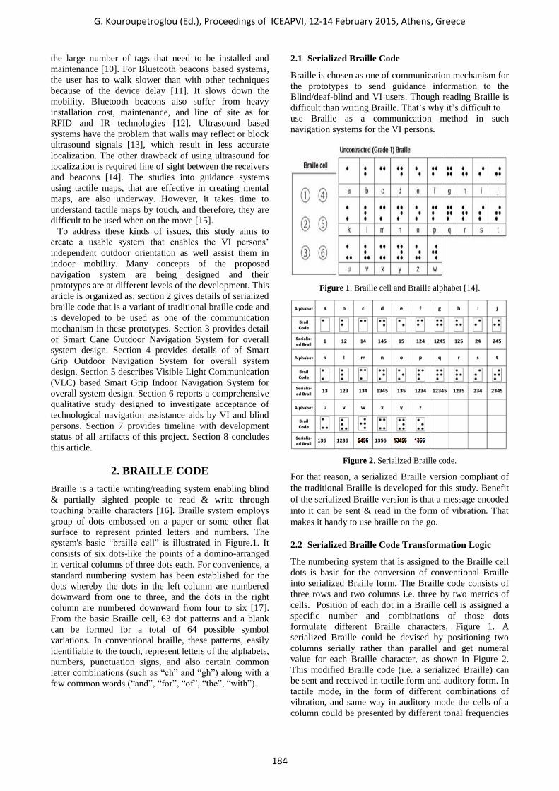
2. BRAILLE CODE
Braille is a tactile writing/reading system enabling blind
& partially sighted people to read & write through
touching braille characters [16]. Braille system employs
group of dots embossed on a paper or some other flat
surface to represent printed letters and numbers. The
system's basic “braille cell” is illustrated in Figure.1. It
consists of six dots-like the points of a domino-arranged
in vertical columns of three dots each. For convenience, a
standard numbering system has been established for the
dots whereby the dots in the left column are numbered
downward from one to three, and the dots in the right
column are numbered downward from four to six [17].
From the basic Braille cell, 63 dot patterns and a blank
can be formed for a total of 64 possible symbol
variations. In conventional braille, these patterns, easily
identifiable to the touch, represent letters of the alphabets,
numbers, punctuation signs, and also certain common
letter combinations (such as “ch” and “gh”) along with a
few common words (“and”, “for”, “of”, “the”, “with”).
2.1 Serialized Braille Code
Braille is chosen as one of communication mechanism for
the prototypes to send guidance information to the
Blind/deaf-blind and VI users. Though reading Braille is
difficult than writing Braille. That’s why it’s difficult to
use Braille as a communication method in such
navigation systems for the VI persons.
Figure 1. Braille cell and Braille alphabet [14].
Figure 2. Serialized Braille code.
For that reason, a serialized Braille version compliant of
the traditional Braille is developed for this study. Benefit
of the serialized Braille version is that a message encoded
into it can be sent & read in the form of vibration. That
makes it handy to use braille on the go.
2.2 Serialized Braille Code Transformation Logic
The numbering system that is assigned to the Braille cell
dots is basic for the conversion of conventional Braille
into serialized Braille form. The Braille code consists of
three rows and two columns i.e. three by two metrics of
cells. Position of each dot in a Braille cell is assigned a
specific number and combinations of those dots
formulate different Braille characters, Figure 1. A
serialized Braille could be devised by positioning two
columns serially rather than parallel and get numeral
value for each Braille character, as shown in Figure 2.
This modified Braille code (i.e. a serialized Braille) can
be sent and received in tactile form and auditory form. In
tactile mode, in the form of different combinations of
vibration, and same way in auditory mode the cells of a
column could be presented by different tonal frequencies
G. Kouroupetroglou (Ed.), Proceedings of ICEAPVI, 12-14 February 2015, Athens, Greece
184
and combinations (i.e. distinctive time gape with tones).
A serialized code could be easily leaned by blind persons
who have already learned original Braille code. Tactile
mode would be especially advantageous for the deaf
blind users.
3. SMART CANE OUTDOOR
NAVIGATION SYSTEM
Smart cane outdoor navigation system is a navigation
system designed to enable VI persons’ walking
independently in urban areas and help them finding
points of interest (POI) around e.g. post office, shopping
mall, coffee shop etc. Augmented cane, stationary magnet
points’ trail, metallic trail, and transmission of guidance
information to VI persons in the form of serialized Brail
vibrations through pulsing magnet apparatus are the
features of the navigation system. Magnet points trail and
metallic trail are two of the contending components of the
proposed system. Either of these will be chosen as
component of the system after end user tests. Magnetic
points’ trail or metallic trail and pulsing magnet apparatus
will be installed on special sidewalk for the VI persons in
the city centers. VI persons can follow the trail of
magnetism or metallic trail on sidewalks using
augmented cane and walk independently being oriented
towards their destination. They are informed about POI
along the sidewalk through serialized braille encoded
guidance messages relayed through pulsing magnet
apparatus in the form of serialized Braille vibration. VI
persons can sense the serialized Braille vibrations
through the augmented cane and become aware of POI
ahead. By decoding the serialized Braille code, they can
get guidance information about underlying POI.
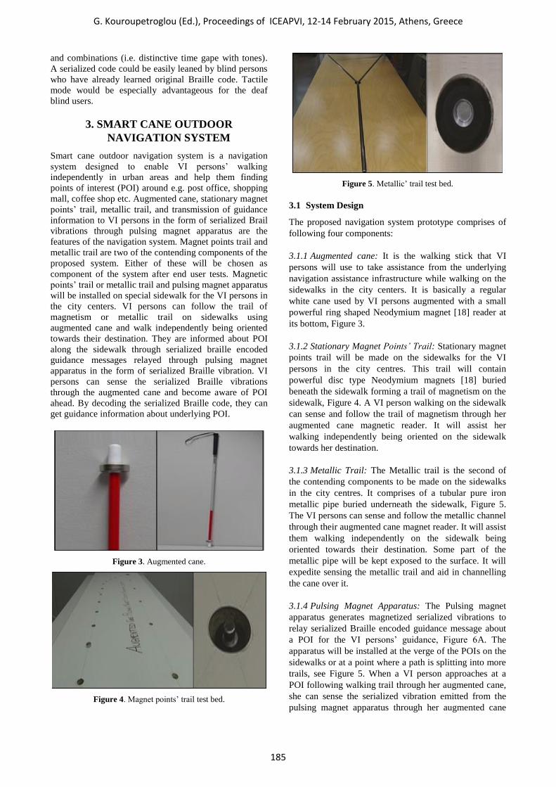
Figure 3. Augmented cane.
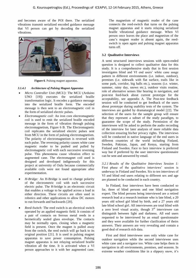
Figure 4. Magnet points’ trail test bed.
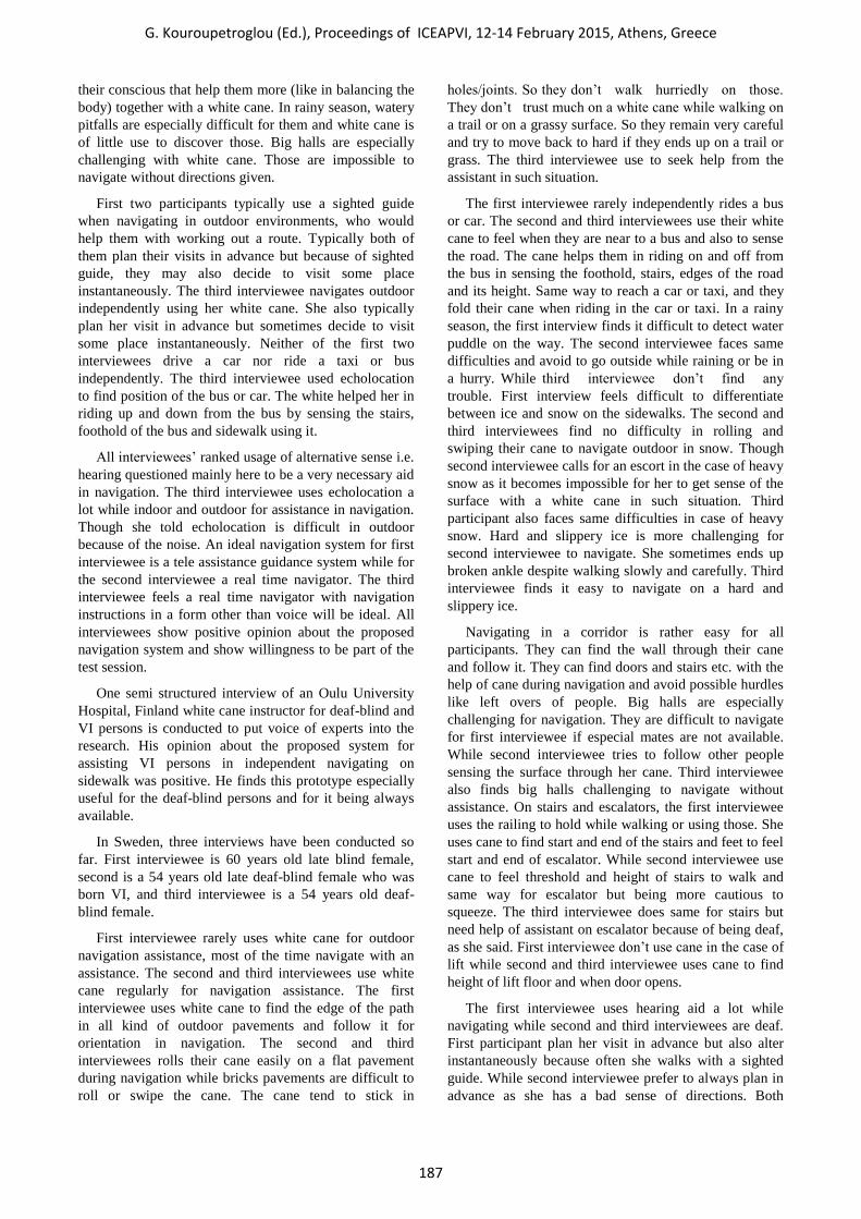
Figure 5. Metallic’ trail test bed.
3.1 System Design
The proposed navigation system prototype comprises of
following four components:
3.1.1 Augmented cane: It is the walking stick that VI
persons will use to take assistance from the underlying
navigation assistance infrastructure while walking on the
sidewalks in the city centers. It is basically a regular
white cane used by VI persons augmented with a small
powerful ring shaped Neodymium magnet [18] reader at
its bottom, Figure 3.
3.1.2 Stationary Magnet Points’ Trail: Stationary magnet
points trail will be made on the sidewalks for the VI
persons in the city centres. This trail will contain
powerful disc type Neodymium magnets [18] buried
beneath the sidewalk forming a trail of magnetism on the
sidewalk, Figure 4. A VI person walking on the sidewalk
can sense and follow the trail of magnetism through her
augmented cane magnetic reader. It will assist her
walking independently being oriented on the sidewalk
towards her destination.
3.1.3 Metallic Trail: The Metallic trail is the second of
the contending components to be made on the sidewalks
in the city centres. It comprises of a tubular pure iron
metallic pipe buried underneath the sidewalk, Figure 5.
The VI persons can sense and follow the metallic channel
through their augmented cane magnet reader. It will assist
them walking independently on the sidewalk being
oriented towards their destination. Some part of the
metallic pipe will be kept exposed to the surface. It will
expedite sensing the metallic trail and aid in channelling
the cane over it.
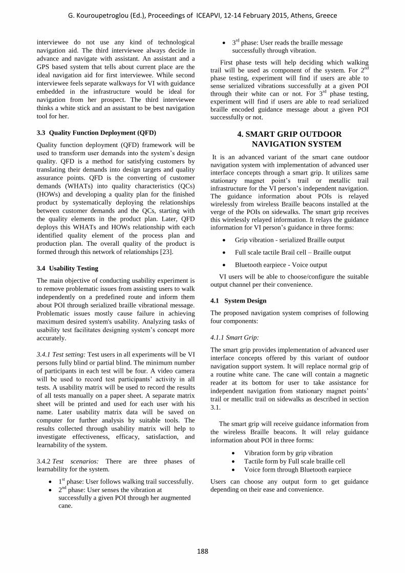
3.1.4 Pulsing Magnet Apparatus: The Pulsing magnet
apparatus generates magnetized serialized vibrations to
relay serialized Braille encoded guidance message about
a POI for the VI persons’ guidance, Figure 6A. The
apparatus will be installed at the verge of the POIs on the
sidewalks or at a point where a path is splitting into more
trails, see Figure 5. When a VI person approaches at a
POI following walking trail through her augmented cane,
she can sense the serialized vibration emitted from the
pulsing magnet apparatus through her augmented cane
G. Kouroupetroglou (Ed.), Proceedings of ICEAPVI, 12-14 February 2015, Athens, Greece
185
and becomes aware of the POI there. The serialized
vibrations transmit serialized encoded guidance message
that VI person can get by decoding the serialized
vibrations.
Figure 6. Pulsing magnet apparatus.
3.1.4.1 Architecture of Pulsing Magnet Apparatus
Micro Controller Unit (MCU): The MCU (Arduino
UNO [19]) executes the serialized braille
transformation logic. It encodes a guidance message
into the serialized braille form. The encoded
message is then sent to an electromagnetic coil in
the form of serialized electric pulses.
Electromagnetic coil: An iron core electromagnetic
coil is used to emit the serialized braille encoded
message in the form of vibration through pulsing
electromagnetism, Figure 6 B. The Electromagnetic
coil replicates the serialized electric pulses sent
from MCU in the form of pulsing electromagnetism.
The polarity of electromagnetism is reversed with
each pulse. The reversing polarity causes white cane
magnetic reader to be pushed and pulled by
electromagnetic coil with each successive reversing
pulse. This phenomena cause vibration effect to
augmented cane. The electromagnet coil used is
designed and developed indigenously for this
project at university of Oulu because commercially
available coils were not found appropriate after
experimentation.
H-Bridge: An H-Bridge is used to change polarity
of the electrometric coil with each successive
electric pulse. The H-bridge is an electronic circuit
that enables a voltage to be applied across a load in
either direction. These circuits are often used in
robotics and other applications to allow DC motors
to run forwards and backwards [20].
Reed-Switch: The reed switch is an electrical switch
operated by an applied magnetic field. It consists of
a pair of contacts on ferrous metal reeds in a
hermetically sealed glass envelope. The contacts
may be normally open, closing when a magnetic
field is present. Once the magnet is pulled away
from the switch, the reed switch will go back to its
original position [21]. It is used in pulsing magnet
apparatus to save power consumption. Pulsing
magnet apparatus is not relaying serialized braille
vibration all the time. It is activated when a VI
person approaches to it with her augmented cane.
The magnetism of magnetic reader of the cane
connects the reed-switch that turns on the pulsing
magnet apparatus and it starts relaying serialized
braille vibrational guidance message. When VI
person once leaves the place and magnetism of the
cane’s magnet reader is absent again, the reed-
switch is open again and pulsing magnet apparatus
turns off.
3.2 Qualitative Interviews
A semi structured interviews sessions with open-ended
question is designed to collect qualitative data for this
study. It is a comprehensive study that in first session
investigates blind and VI end users’ white cane usage
pattern in different environments (i.e. indoor, outdoor),
premises (i.e. sidewalk with flat surface, trails like in
some park, corridor, big halls etc.), seasons (i.e. winter,
summer, rainy day, snows etc.), outdoor visits routine,
role of alternative senses like hearing in navigation, and
post-test feed-back about current prototype for the
acceptability, see appendix A. The Post-test feedback
session will be conducted to get feedback of the users
about prototype during usability tests of the system. The
interviews are guided by dramaturgical model [22]. The
selection of the users for the sample group will ensure
that they represent a subset of the study paradigm, to
guarantee the scope of the study. Permission of the
interviewee will be asked to perform the audio recording
of the interview for later analysis of more reliable data
collection ensuring his/her privacy rights. The interviews
will be conducted in native language of the end users in
different countries of the world including Finland,
Sweden, Pakistan, Japan, and Kenya, starting from
Finland and Sweden. Face to face interview is preferred
way but if preferred by the user interview questionnaire
can be sent and answered by email.
3.2.1 Results of the Qualitative Interviews Session 1:
First phase of the qualitative interviews’ session is
underway in Finland and Sweden. Six to ten interviews of
VI and blind end users relating to different sex and age
are planned to be conducted in each country.
In Finland, four interviews have been conducted so
far, three of blind persons and one blind navigation
expert. The blind persons being interviewed are a retired
research lead at a research institute who is late blind, a 20
years old school girl blind by birth, and a 27 years old
late blind school girl. All interviewees are total blind with
a zero level visual acuity, though 3rd
interviewee can
distinguish between light and darkness. All end users
requested to be interviewed by an email questionnaire
and they were available for further clarification of theirs
answers. Their answers are very revealing and contain a
good deal of research rich data.
First and third interviewee uses only white cane for
outdoor navigation while the second interviewee uses
white cane and a navigator too. White cane helps them in
navigation in all environments, premises, and seasons. In
extreme weather conditions like in a slippery snow, it’s
G. Kouroupetroglou (Ed.), Proceedings of ICEAPVI, 12-14 February 2015, Athens, Greece
186
their conscious that help them more (like in balancing the
body) together with a white cane. In rainy season, watery
pitfalls are especially difficult for them and white cane is
of little use to discover those. Big halls are especially
challenging with white cane. Those are impossible to
navigate without directions given.
First two participants typically use a sighted guide
when navigating in outdoor environments, who would
help them with working out a route. Typically both of
them plan their visits in advance but because of sighted
guide, they may also decide to visit some place
instantaneously. The third interviewee navigates outdoor
independently using her white cane. She also typically
plan her visit in advance but sometimes decide to visit
some place instantaneously. Neither of the first two
interviewees drive a car nor ride a taxi or bus
independently. The third interviewee used echolocation
to find position of the bus or car. The white helped her in
riding up and down from the bus by sensing the stairs,
foothold of the bus and sidewalk using it.
All interviewees’ ranked usage of alternative sense i.e.
hearing questioned mainly here to be a very necessary aid
in navigation. The third interviewee uses echolocation a
lot while indoor and outdoor for assistance in navigation.
Though she told echolocation is difficult in outdoor
because of the noise. An ideal navigation system for first
interviewee is a tele assistance guidance system while for
the second interviewee a real time navigator. The third
interviewee feels a real time navigator with navigation
instructions in a form other than voice will be ideal. All
interviewees show positive opinion about the proposed
navigation system and show willingness to be part of the
test session.
One semi structured interview of an Oulu University
Hospital, Finland white cane instructor for deaf-blind and
VI persons is conducted to put voice of experts into the
research. His opinion about the proposed system for
assisting VI persons in independent navigating on
sidewalk was positive. He finds this prototype especially
useful for the deaf-blind persons and for it being always
available.
In Sweden, three interviews have been conducted so
far. First interviewee is 60 years old late blind female,
second is a 54 years old late deaf-blind female who was
born VI, and third interviewee is a 54 years old deaf-
blind female.
First interviewee rarely uses white cane for outdoor
navigation assistance, most of the time navigate with an
assistance. The second and third interviewees use white
cane regularly for navigation assistance. The first
interviewee uses white cane to find the edge of the path
in all kind of outdoor pavements and follow it for
orientation in navigation. The second and third
interviewees rolls their cane easily on a flat pavement
during navigation while bricks pavements are difficult to
roll or swipe the cane. The cane tend to stick in
holes/joints. So they don’t walk hurriedly on those.
They don’t trust much on a white cane while walking on
a trail or on a grassy surface. So they remain very careful
and try to move back to hard if they ends up on a trail or
grass. The third interviewee use to seek help from the
assistant in such situation.
The first interviewee rarely independently rides a bus
or car. The second and third interviewees use their white
cane to feel when they are near to a bus and also to sense
the road. The cane helps them in riding on and off from
the bus in sensing the foothold, stairs, edges of the road
and its height. Same way to reach a car or taxi, and they
fold their cane when riding in the car or taxi. In a rainy
season, the first interview finds it difficult to detect water
puddle on the way. The second interviewee faces same
difficulties and avoid to go outside while raining or be in
a hurry. While third interviewee don’t find any
trouble. First interview feels difficult to differentiate
between ice and snow on the sidewalks. The second and
third interviewees find no difficulty in rolling and
swiping their cane to navigate outdoor in snow. Though
second interviewee calls for an escort in the case of heavy
snow as it becomes impossible for her to get sense of the
surface with a white cane in such situation. Third
participant also faces same difficulties in case of heavy
snow. Hard and slippery ice is more challenging for
second interviewee to navigate. She sometimes ends up
broken ankle despite walking slowly and carefully. Third
interviewee finds it easy to navigate on a hard and
slippery ice.
Navigating in a corridor is rather easy for all
participants. They can find the wall through their cane
and follow it. They can find doors and stairs etc. with the
help of cane during navigation and avoid possible hurdles
like left overs of people. Big halls are especially
challenging for navigation. They are difficult to navigate
for first interviewee if especial mates are not available.
While second interviewee tries to follow other people
sensing the surface through her cane. Third interviewee
also finds big halls challenging to navigate without
assistance. On stairs and escalators, the first interviewee
uses the railing to hold while walking or using those. She
uses cane to find start and end of the stairs and feet to feel
start and end of escalator. While second interviewee use
cane to feel threshold and height of stairs to walk and
same way for escalator but being more cautious to
squeeze. The third interviewee does same for stairs but
need help of assistant on escalator because of being deaf,
as she said. First interviewee don’t use cane in the case of
lift while second and third interviewee uses cane to find
height of lift floor and when door opens.
The first interviewee uses hearing aid a lot while
navigating while second and third interviewees are deaf.
First participant plan her visit in advance but also alter
instantaneously because often she walks with a sighted
guide. While second interviewee prefer to always plan in
advance as she has a bad sense of directions. Both
G. Kouroupetroglou (Ed.), Proceedings of ICEAPVI, 12-14 February 2015, Athens, Greece
187
interviewee do not use any kind of technological
navigation aid. The third interviewee always decide in
advance and navigate with assistant. An assistant and a
GPS based system that tells about current place are the
ideal navigation aid for first interviewee. While second
interviewee feels separate walkways for VI with guidance
embedded in the infrastructure would be ideal for
navigation from her prospect. The third interviewee
thinks a white stick and an assistant to be best navigation
tool for her.
3.3 Quality Function Deployment (QFD)
Quality function deployment (QFD) framework will be
used to transform user demands into the system’s design
quality. QFD is a method for satisfying customers by
translating their demands into design targets and quality
assurance points. QFD is the converting of customer
demands (WHATs) into quality characteristics (QCs)
(HOWs) and developing a quality plan for the finished
product by systematically deploying the relationships
between customer demands and the QCs, starting with
the quality elements in the product plan. Later, QFD
deploys this WHATs and HOWs relationship with each
identified quality element of the process plan and
production plan. The overall quality of the product is
formed through this network of relationships [23].
3.4 Usability Testing
The main objective of conducting usability experiment is
to remove problematic issues from assisting users to walk
independently on a predefined route and inform them
about POI through serialized braille vibrational message.
Problematic issues mostly cause failure in achieving
maximum desired system's usability. Analyzing tasks of
usability test facilitates designing system’s concept more
accurately.
3.4.1 Test setting: Test users in all experiments will be VI
persons fully blind or partial blind. The minimum number
of participants in each test will be four. A video camera
will be used to record test participants’ activity in all
tests. A usability matrix will be used to record the results
of all tests manually on a paper sheet. A separate matrix
sheet will be printed and used for each user with his
name. Later usability matrix data will be saved on
computer for further analysis by suitable tools. The
results collected through usability matrix will help to
investigate effectiveness, efficacy, satisfaction, and
learnability of the system.
3.4.2 Test scenarios: There are three phases of
learnability for the system.
1st phase: User follows walking trail successfully.
2nd
phase: User senses the vibration at
successfully a given POI through her augmented
cane.
3rd
phase: User reads the braille message
successfully through vibration.
First phase tests will help deciding which walking
trail will be used as component of the system. For 2nd
phase testing, experiment will find if users are able to
sense serialized vibrations successfully at a given POI
through their white can or not. For 3rd
phase testing,
experiment will find if users are able to read serialized
braille encoded guidance message about a given POI
successfully or not.
4. SMART GRIP OUTDOOR
NAVIGATION SYSTEM
It is an advanced variant of the smart cane outdoor
navigation system with implementation of advanced user
interface concepts through a smart grip. It utilizes same
stationary magnet point’s trail or metallic trail
infrastructure for the VI person’s independent navigation.
The guidance information about POIs is relayed
wirelessly from wireless Braille beacons installed at the
verge of the POIs on sidewalks. The smart grip receives
this wirelessly relayed information. It relays the guidance
information for VI person’s guidance in three forms:
Grip vibration - serialized Braille output
Full scale tactile Brail cell – Braille output
Bluetooth earpiece - Voice output
VI users will be able to choose/configure the suitable
output channel per their convenience.
4.1 System Design
The proposed navigation system comprises of following
four components:
4.1.1 Smart Grip:
The smart grip provides implementation of advanced user
interface concepts offered by this variant of outdoor
navigation support system. It will replace normal grip of
a routine white cane. The cane will contain a magnetic
reader at its bottom for user to take assistance for
independent navigation from stationary magnet points’
trail or metallic trail on sidewalks as described in section
3.1.
The smart grip will receive guidance information from
the wireless Braille beacons. It will relay guidance
information about POI in three forms:
Vibration form by grip vibration
Tactile form by Full scale braille cell
Voice form through Bluetooth earpiece
Users can choose any output form to get guidance
depending on their ease and convenience.
G. Kouroupetroglou (Ed.), Proceedings of ICEAPVI, 12-14 February 2015, Athens, Greece
188
4.1.2 Wireless Braille beacon
The wireless Braille beacons relay guidance information
to VI persons wirelessly. These will be installed at the
verge of POIs on sidewalks.
4.1.3 Magnet Points’ Trail
Magnet points’ trail works same way as in the case of
smart cane outdoor navigation system, section 3.1.2.
4.1.4 Metallic Trail
Metallic trail works same way as in the case of smart
cane outdoor navigation system, section 3.1.3.
5. VISIBLE LIGHT COMMUNICATION
BASED SMART GRIP INDOOR
NAVIGATION SYSTEM
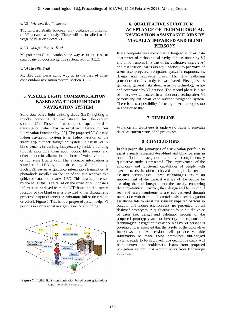
Solid-state-based light emitting diode (LED) lighting is
rapidly becoming the mainstream for illumination
solutions [24]. These luminaries are also capable for data
transmission, which has no negative influence to their
illumination functionality [25]. The proposed VLC based
indoor navigation system is an indoor version of the
smart grip outdoor navigation system. It assists VI &
blind persons in walking independently inside a building
through informing them about doors, lifts, stairs, and
other indoor installation in the form of voice, vibration,
or full scale Braille cell. The guidance information is
stored in the LED lights on the ceiling of the building.
Each LED serves as guidance information transmitter. A
photodiode installed on the top of the grip receives this
guidance data from nearest LED. This data is processed
by the MCU that is installed on the smart grip. Guidance
information retrieved from the LED based on the current
location of the blind user is provided to her through any
preferred output channel (i.e. vibration, full scale Braille,
or voice), Figure 7. This is how proposed system helps VI
persons in independent navigation inside a building.
Figure 7. Visible light communication based smart grip indoor
navigation system scenario.
6. QUALITATIVE STUDY FOR
ACEPTANCE OF TECHNOLOGICAL
NAVIGATION ASSISTANCE AIDS BY
VISUALLY IMPAIRED AND BLIND
PERSONS
It is a comprehensive study that is designed to investigate
acceptance of technological navigation assistance by VI
and blind persons. It is part of the qualitative interviews’
and test session that is already underway to put voice of
users into proposed navigation system’s requirements,
design, and validation phase. The data gathering
procedure for this study is two-phased. First phase is
gathering general data about assistive technology usage
and acceptance by VI persons. The second phase is a set
of interviews conducted in a laboratory setting after VI
persons try out smart cane outdoor navigation system.
There is also a possibility for using other prototypes too
in addition to that.
7. TIMELINE
Work on all prototypes is underway. Table 1 provides
detail of current status of all prototypes.
8. CONCLUSIONS
In this paper, the prototypes of a navigation portfolio to
assist visually impaired deaf-blind and blind persons in
outdoor/indoor navigation and a complementary
qualitative study is presented. The improvement of the
autonomy and functional capabilities of people with
special needs is often achieved through the use of
assistive technologies. These technologies ensure an
improvement of the general welfare of the people by
assisting them to integrate into the society, enhancing
their capabilities. However, their design will be limited if
real end users requirements are not gathered through
interaction with them. In this article, advanced navigation
assistance aids to assist the visually impaired persons in
outdoor and indoor environment are presented for all
designed prototypes. A qualitative study to put the voice
of users into design and validation process of the
proposed prototypes and to investigate acceptance of
technological navigation assistance aids by VI persons is
presented. It is expected that the results of the qualitative
interviews and test sessions will provide valuable
information to make these prototypes full-fledged
systems ready to be deployed. The qualitative study will
help remove the problematic issues from proposed
navigation systems that restrain users from technology
adoption.
G. Kouroupetroglou (Ed.), Proceedings of ICEAPVI, 12-14 February 2015, Athens, Greece
189
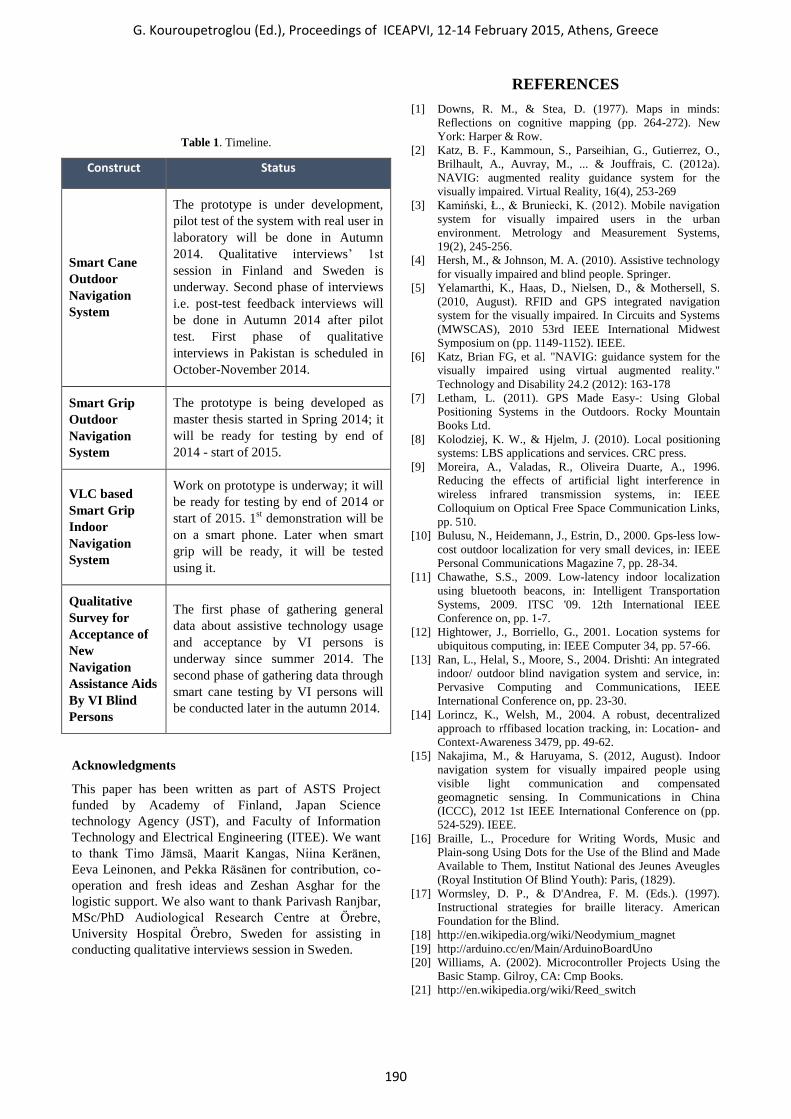
Table 1. Timeline.
Construct Status
Smart Cane
Outdoor
Navigation
System
The prototype is under development,
pilot test of the system with real user in
laboratory will be done in Autumn
2014. Qualitative interviews’ 1st
session in Finland and Sweden is
underway. Second phase of interviews
i.e. post-test feedback interviews will
be done in Autumn 2014 after pilot
test. First phase of qualitative
interviews in Pakistan is scheduled in
October-November 2014.
Smart Grip
Outdoor
Navigation
System
The prototype is being developed as
master thesis started in Spring 2014; it
will be ready for testing by end of
2014 - start of 2015.
VLC based
Smart Grip
Indoor
Navigation
System
Work on prototype is underway; it will
be ready for testing by end of 2014 or
start of 2015. 1st demonstration will be
on a smart phone. Later when smart
grip will be ready, it will be tested
using it.
Qualitative
Survey for
Acceptance of
New
Navigation
Assistance Aids
By VI Blind
Persons
The first phase of gathering general
data about assistive technology usage
and acceptance by VI persons is
underway since summer 2014. The
second phase of gathering data through
smart cane testing by VI persons will
be conducted later in the autumn 2014.
Acknowledgments
This paper has been written as part of ASTS Project
funded by Academy of Finland, Japan Science
technology Agency (JST), and Faculty of Information
Technology and Electrical Engineering (ITEE). We want
to thank Timo Jämsä, Maarit Kangas, Niina Keränen,
Eeva Leinonen, and Pekka Räsänen for contribution, co-
operation and fresh ideas and Zeshan Asghar for the
logistic support. We also want to thank Parivash Ranjbar,
MSc/PhD Audiological Research Centre at Örebre,
University Hospital Örebro, Sweden for assisting in
conducting qualitative interviews session in Sweden.
REFERENCES
[1] Downs, R. M., & Stea, D. (1977). Maps in minds:
Reflections on cognitive mapping (pp. 264-272). New
York: Harper & Row.
[2] Katz, B. F., Kammoun, S., Parseihian, G., Gutierrez, O.,
Brilhault, A., Auvray, M., ... & Jouffrais, C. (2012a).
NAVIG: augmented reality guidance system for the
visually impaired. Virtual Reality, 16(4), 253-269
[3] Kamiński, Ł., & Bruniecki, K. (2012). Mobile navigation
system for visually impaired users in the urban
environment. Metrology and Measurement Systems,
19(2), 245-256.
[4] Hersh, M., & Johnson, M. A. (2010). Assistive technology
for visually impaired and blind people. Springer.
[5] Yelamarthi, K., Haas, D., Nielsen, D., & Mothersell, S.
(2010, August). RFID and GPS integrated navigation
system for the visually impaired. In Circuits and Systems
(MWSCAS), 2010 53rd IEEE International Midwest
Symposium on (pp. 1149-1152). IEEE.
[6] Katz, Brian FG, et al. "NAVIG: guidance system for the
visually impaired using virtual augmented reality."
Technology and Disability 24.2 (2012): 163-178
[7] Letham, L. (2011). GPS Made Easy-: Using Global
Positioning Systems in the Outdoors. Rocky Mountain
Books Ltd.
[8] Kolodziej, K. W., & Hjelm, J. (2010). Local positioning
systems: LBS applications and services. CRC press.
[9] Moreira, A., Valadas, R., Oliveira Duarte, A., 1996.
Reducing the effects of artificial light interference in
wireless infrared transmission systems, in: IEEE
Colloquium on Optical Free Space Communication Links,
pp. 510.
[10] Bulusu, N., Heidemann, J., Estrin, D., 2000. Gps-less low-
cost outdoor localization for very small devices, in: IEEE
Personal Communications Magazine 7, pp. 28-34.
[11] Chawathe, S.S., 2009. Low-latency indoor localization
using bluetooth beacons, in: Intelligent Transportation
Systems, 2009. ITSC '09. 12th International IEEE
Conference on, pp. 1-7.
[12] Hightower, J., Borriello, G., 2001. Location systems for
ubiquitous computing, in: IEEE Computer 34, pp. 57-66.
[13] Ran, L., Helal, S., Moore, S., 2004. Drishti: An integrated
indoor/ outdoor blind navigation system and service, in:
Pervasive Computing and Communications, IEEE
International Conference on, pp. 23-30.
[14] Lorincz, K., Welsh, M., 2004. A robust, decentralized
approach to rffibased location tracking, in: Location- and
Context-Awareness 3479, pp. 49-62.
[15] Nakajima, M., & Haruyama, S. (2012, August). Indoor
navigation system for visually impaired people using
visible light communication and compensated
geomagnetic sensing. In Communications in China
(ICCC), 2012 1st IEEE International Conference on (pp.
524-529). IEEE.
[16] Braille, L., Procedure for Writing Words, Music and
Plain-song Using Dots for the Use of the Blind and Made
Available to Them, Institut National des Jeunes Aveugles
(Royal Institution Of Blind Youth): Paris, (1829).
[17] Wormsley, D. P., & D'Andrea, F. M. (Eds.). (1997).
Instructional strategies for braille literacy. American
Foundation for the Blind.
[18] http://en.wikipedia.org/wiki/Neodymium_magnet
[19] http://arduino.cc/en/Main/ArduinoBoardUno
[20] Williams, A. (2002). Microcontroller Projects Using the
Basic Stamp. Gilroy, CA: Cmp Books.
[21] http://en.wikipedia.org/wiki/Reed_switch
G. Kouroupetroglou (Ed.), Proceedings of ICEAPVI, 12-14 February 2015, Athens, Greece
190
[22] Myers, M. D., & Newman, M. (2007). The qualitative
interview in IS research: Examining the craft. Information
and organization, 17(1), 2-26.
[23] Akao, Y. (2004). Quality function deployment: integrating
customer requirements into product design. Productivity
Press.
[24] Hanzo, L., Haas, H., Imre, S., O'Brien, D., Rupp, M., &
Gyongyosi, L. (2012). Wireless myths, realities, and
futures: from 3G/4G to optical and quantum wireless.
Proceedings of the IEEE, 100(Special Centennial Issue),
1853-1888.
[25] O’Brien, D. C., Katz, M., Wang, P., Kalliojarvi, K.,
Arnon, S., Matsumoto, M., ... & Jivkova, S. (2005). Short-
range optical wireless communications. In Wireless world
research forum (pp. 1-22).
G. Kouroupetroglou (Ed.), Proceedings of ICEAPVI, 12-14 February 2015, Athens, Greece
191
APPENDIX A
List of Questions for interview Session 1
Theoretical
Construct
Questions Indicators
Introduction
Categorizing
Characteristics
of interviewee-I
Outdoor Cane
Usage
Indoor Cane
Usage
Alternative
navigation aid and
decision making
Suggestion
Categorizing
Characteristics of
interviewee - II
Post demo
feedback
1. Who we are and why we are doing this interview (general
introduction)?
2. Do you use white cane for navigation assistance?
3. How do you use cane on sidewalk that surface is flat? 4. How do you use cane on walking street that is built by bricks?
5. How do you use cane on a trail like in some of parks?
6. How do you manage to ride a bus, taxi, or private car?
7. How do you use cane when it’s raining outside?
8. How do you use cane in soft snow outside?
9. How do you use cane in hard snow outside?
10. How do you use cane in hard slippery snow outside?
11. How do you use cane in corridor? 12. How do you use cane in a big hall
13. How do you use cane on stairs?
14. How do you use cane on an escalator?
15. How do you use cane in a lift?
16. How hearing help you in navigation outdoor and navigation indoor? 17. Do you plan your visit in advance or do you make decision where to
visit while walking? 18. What are the places you visit in Summer and
in winter and how often?
19. Do you use any kind of assistance technology? 20. What is ideal
guidance system for you? 21. How would you compare this system with other navigation
systems?
22. What is your date of birth?
23. Do you lose sight late or blind by birth?
24. What is the cause of your visual impairment? 25. On a scale of 1-5 where 1 means nonexistent and 5 means perfect,
how would you rate your vision in the following areas:
a. Visual acuity
b. Field of vision
c. Night blindness d. Sensitivity to light
e. Color blindness
26. What do you think of this system?
27. How do you compare this system with any navigation assistance
your currently use for outdoor navigation like ordinary white cane or
any navigator application?
28. What potential difficulties of yours when you navigate outdoor do you think this system could solve?
29. Would you like to use this system?
Acquaintance
White cane acquaintance
Urban environment cane
usage pattern
Transportation usage
Seasonal cane usage
pattern
Indoor cane usage pattern
How much info to be
relayed about POIs
View of ideal navigation
aid
Background info
Degree & reason of
blindness
End users view and
acceptance of proposed
system
G. Kouroupetroglou (Ed.), Proceedings of ICEAPVI, 12-14 February 2015, Athens, Greece
192