ADF&G Flooded Gravel Mine Studies Since 1 986 and an Arctic ...
46
ADF&G Flooded Gravel Mine Studies Since 1 986 and an Arctic Grayling Experimental Transplant Into a Small Tundra Drainage A Synthesis by S.M. Roach Technical Report No. 93-6 Alaska Department of Fish and Game Habitat and Restoration Division
Transcript of ADF&G Flooded Gravel Mine Studies Since 1 986 and an Arctic ...

ADFampG Flooded Gravel Mine Studies Since 1 986 and an Arctic Grayling Experimental Transplant
Into a Small Tundra Drainage
A Synthesis
by
SM Roach
Technical Report No 93-6
Alaska Department of Fish and Game Habitat and Restoration Division
ADFM FLOODED GRAVEL MINE STUDIES
SINCE 1986 AND AN ARCTIC GRAYLING EXPERIMENTAL
TRANSPLANT INTO A SMALL TUNDRA DRAINAGE
A SYNTHESIS
by S M Roach
Technical Report No 93-6
Frank Rue Director
Habitat and Restoration Division Alaska Department of Fish and Game
P 0 Box 3-2000 Juneau Alaska 99802
April 1993
TABLE OF CONTENTS
LIST OF TABLES
Page
i i i
LIST OF FIGURES
ABSTRACT
PART I
FLOODED GRAVEL MINE SITES STUDIED SINCE 1986
Introduction
Description of Mine Sites
Mine Sites In Large Drainages
ARC0 Sag Site C Otts Oxbow Goose Green Gulch Kuparuk Deada rm
Mine Sites In Small Tundra Drainages
Kuparuk Mine Site D Kuparuk Mine Site B
Lower Put River Mine Site and Put 27
Biological and Limnological Sampling
Methods Fish Surveys Zooplankton Surveys
Phytoplankton Surveys
Chemical Evaluations Results
Fish Surveys Zooplankton Surveys
Phytoplankton Surveys
TABLE OF CONTENTS (Continued)
Chemical Evaluations Discussion
PART I1
ARCTIC GRAYLING TRANSPLANT INTO A SMALL TUNDRA DRAINAGE
Introduction
Methods
Results
Discussion
ACKNOWLEDGMENTS
LITERATURE CITED
LIST OF TABLES
Table
1 North Slope flooded gravel mine s i t e s inves t iga ted by
Hab i t a t Divis ion of the Alaska Department of Fish and Game
s i n c e 1986
Page
5
2 Number of flooded gravel mine s i t e s t h a t ADFampG personnel
captured f i s h by species and type of drainage a l l s i t e s
(N-7) s i t e s wi th in l a r g e r i v e r drainages (n==4) and s i t e s
w i t h i n smal l tundra drainages (n-3) 13
3 F i sh spec ies captured i n North Slope flooded gravel mines
a f t e r i n i t i a l f looding 15
4 Fish spec ies captured i n North Slope flooded gravel mines
a f t e r i n i t i a l f looding and a f t e r h a b i t a t enhancement 16
5 Zooplankton c o l l e c t e d from flooded gravel mine s i t e s by
taxonomic group (Class Order and Family) 20
6 Estimated d e n s i t y of small zooplankton (Cladocera lt 075 mm
Copepoda lt 050 mm) and l a r g e zooplankton (Cladocera gt 075 mm Copepoda gt 050 mm) i n four North Slope gravel mine
s i t e s (adopted from Hemming e t a l 1989) 2 2
7 Average concent ra t ions of chlorophyl l -a i n f i v e North Slope
flooded gravel mine s i t e s by year and month (adopted from
Hemming e t a l 1989) (Samples from each s i t e ranged from
two t o s i x ) 2 3
8 Average concent ra t ions and r a t i o s t o chlorophyl l -a of
ch lorophyl l -b and chlorophyl l -c i n four North Slope flooded
gravel mine s i t e s from da ta c o l l e c t e d i n May J u l y and
August 1988 (adopted from Hemming e t a l 1989) 2 4
iii
LIST OF TABLES (Continued)
Table
9 Average water temperature (temp) dissolved oxygen (DO)
acidity (pH) conductivity (cond) alkalinity (alk) and
hardness (hard) values for North Slope flooded gravel mines
by month and site 2 6
LIST OF FIGURES
Figure Page
1 Number of species captured in North Slope flooded gravel
mines before and after habitat enhancement 17
2 Number of freshwater resident species captured in North Slope
flooded gravel mines from large river and small tundra
drainages 18
3 Number of species captured in North Slope flooded gravel
mines from large river and small tundra drainages 19
4 Average yearly growth rate to length at time of transplanting
of Arctic grayling in Kuparuk Mine Site B transplanted in
1989 and recaptured in 1990 and 1991 34
ABSTRACT
North Slope flooded gravel mine sites investigated since 1986 contain suitable
dissolved oxygen concentrations and sufficient under-ice water during the
winter to provide potential overwintering areas for fish In addition North
Slope flooded gravel mine sites have suitable chemical characteristics
zooplankton abundance and phytoplankton levels to support fish Two or more
species of fish from adjacent waterways colonized each flooded gravel mine
site studied Five or more species of fish colonized three gravel mine sites
modified to enhance fish utilization Rehabilitation efforts at these sites
included providing permanent connections to adjacent waterways increasing
shoreline diversity and creating additional shallow water A greater number
of freshwater resident species were captured in flooded gravel mine sites
associated with the large river drainages of the Kuparuk and Sagavanirktok
River than in flooded gravel mine sites associated with small tundra streams
However ADFM personnel successfully transplanted Arctic grayling in 1989 to
Kuparuk Mine Site B a unique overwintering site in a small tundra drainage
Investigations indicate that at least 20 (95 CI - 20 to 55) of the fish
transplanted survived at least two years Growth rate of transplanted fish
was comparable to age-2 to age-7 Arctic grayling found in a small tundra
stream that drains into the Kavik River Although reproductive success was
not conclusive transplanted fish spawned or were in pre-spawn condition in
1991 and five Arctic grayling were captured near Kuparuk Mine Site B that were
smaller than any of the fish originally transplanted at the site Two of
these fish were estimated to be age-1 Arctic grayling (fork length = 120 mm
and 115 mm) and three estimated to be young-of-the-year Arctic grayling (fork
length lt 38 mm) The observed lengths of these small Arctic grayling are
consistent with the premise that they were the spawning progeny of the
transplanted fish
PART I
FLOODED GRAVEL MINE SITES STUDIED SINCE 1986
Introduction
Both positive and negative potential effects of gravel mining to the habitat
on the North Slope is of interest to the Alaska Department of Fish and Game
(ADFU) Gravel mining and large scale development of Alaskas North Slope
began after the Prudhoe Bay oil discovery of 1969 and continues today Gravel
is necessary for road construction road maintenance drilling pads and other
projects on the North Slope Construction projects on the North Slope need
more gravel compared to similar projects further south because of the presence
of permafrost Thick layers of gravel besides forming the base for
construction help maintain the thermal regime necessary to prevent permafrost
thawing One large gravel site or a series of sites in one area are not
adequate for projects on the North Slope because gravel sites must be located
close to construction projects and at regular intervals for road maintenance
Construction in Alaska requires short haul distances because of the high costs
of transporting gravel Economical reasons required gravel haul distances of
16 km or less for the maintenance of the Trans-Alaska Pipeline
During early North Slope development gravel was obtained by shallow scraping
of the floodplain gravels Environmental and hydrological considerations led
to state policies that minimized surface disturbances by limiting the number
of mine sites and encouraging large deep multi-user mine sites Potential
effects to the environment from floodplain gravel mining were identified in
the early 1970s (Weeden and Klein 1971 Klein 1973 West 1976) The United
States Fish and Wildlife Service (USFWS) consequently recognized a need to
provide information to resource managers that would help minimize negative
effects to the environment from floodplain gravel mining Woodward-Clyde
Consultants began a study for the USFWS in 1975 which reported on 25 arctic
and sub-arctic gravel mining sites (Woodward-Clyde Consultants 1980) This
study culminated in an arctic and sub-arctic gravel extraction guide (Joyce et
al 1980)
During the five-year Woodward-Clyde study investigations included the
evaluation of eight interior Alaska flooded gravel sites for habitat and fauna
diversity This report suggested that these eight flooded gravel mines
increased local habitat and fauna diversity There was a positive relation
between flooded pits with the greatest fauna diversity and shoreline
vegetation irregular shoreline development one or more islands diversity of
water depths food availability and connection to a stream or river system
(Joyce 1980)
Distributions of fish in the arctic are restricted to deep pools deep lakes
and spring-fed areas during the winter On the North Slope most bodies of
fresh water within small tundra drainages freeze to the bottom during the
winter or lack sufficient oxygen for the overwintering of fish making
overwintering habitat a limiting factor for fish diversity and abundance
(Bendock and Burr 1985 Schmidt et al 1989) For example Craig and Poulin
(1975) identified only two overwintering locations for fish within the tundra
drainage of the Shaviovik River Most deep pools are associated with large
river drainages such as the Sagavanirktok and Kuparuk River drainages
Encouraged by the Woodward-Clyde report and considering the paucity of
overwintering sites for fish on the North Slope ADFW identified North Slope
gravel pit reclamation a priority in 1986 and began studies to investigate
flooded gravel mines on the North Slope ADFampG identified Prudhoe Bay - Kuparuk flooded gravel mine management as an opportunity to benefit fish
wildlife and man Currently in the North Slope oilfield over 320 ha (800
ac) have been mined for gravel The surface area of these sites range from
15 to 468 ha (37 to 117 ac) and range between 118 and 152 m (39 to 50 ft)
below surface elevation ADFM hypothesized that reclaimed deep gravel mines
on the North Slope may provide useable fish and wildlife habitat (eg rearing
and overwintering areas) In addition flooded deep gravel mines may provide
sport fishing opportunities and a source of winter water for domestic and
industrial use This paper provides a synthesis of ADFampG reports on flooded
gravel mines on the North Slope since 1986 (Hemming 1988 Hemming et al 1989
Winters 1990a Winters 1990b Hemming 1990 Hemming 1991)
ADFM investigations of Prudhoe Bay - Kuparuk flooded gravel mines were
designed to
1 determine the presence of fish and other fauna
2 determine the suitability of these sites for overwintering habitat
for fish
3 compare biological and limnological characteristics among the sites
4 identify site features that increase aquatic productivity and site
utilization by fish and wildlife and
5 determine the feasibility of stocking fish in flooded mine sites
within small tundra drainages where the opportunity for colonization
is low
Description of Mine Sites
Habitat and Restoration Division of the ADFampG investigated seven flooded
gravel mines since 1986 Investigations included gravel mine sites in
drainages between the Ugnuravik and Sagavanirktok (Sag) River on the North
Slope of Alaska There was one gravel mining site each in the Ugnuravik East
Creek Kuparuk and Putuligayuk (Put) drainages and three sites in the Sag
drainage (Table 1)
Flooded gravel mine sites are dynamic systems continually changing because of
spring flooding thawing of adjacent ice fields erosion from water and wind
and other natural events Rehabilitation efforts by man are also a source of
change for flooded gravel sites Nature or man has altered several or all the
sites studied since original flooding In addition to flooding the sites the
oil industry completed enhancement projects for Sag Site C Kuparuk Mine Site
B Kuparuk Dead Arm Reservoir 5 and Kuparuk Mine Site D Natural events
notably altered Sag Site C after enhancement efforts
After gravel mine sites fill with water a permanent or temporary connection
to a stream river or lake is necessary for the colonization of fish
Permanent connections provide pathways for open water movement and temporary
Table 1 North Slope flooded gravel mine s i t e s inves t iga ted by Habitat
Division of the Alaska Department of Fish and Game s ince 1986
Year Studied
Drainage S i t e 1986 1987 1988 1989 1990
Sag S i t e C
O t t s Oxbow S i t e
Goose Green Gulch
Kuparuk Deadarm 5 amp 6
Kuparuk D P i t
East Creekb
Kuparuk B P i t
Putb
Put 27 Mine S i t e
a Large r i v e r drainage
Small tundra r i v e r drainage
connections provide pathways for movement during high water events All the
mine sites investigated were either permanently or temporarily connected to
natural water bodies for colonization Flooded gravel mine sites in large
river drainages should have higher fish abundance and more species diversity
than small tundra drainages because the source of colonization is greater in
larger systems
Mine Sites in Large River Drainages
The Kuparuk and Sag drainages are large systems with deep pools and spring-fed
areas which enables the support of several species of freshwater and
anadromous fish throughout the winter (Bendock 1977 Bendock 1982 Bendock and
Burr 1984) There were four gravel mine sites studied in these two large
river drainages three in the Sag drainage (ARCO Sag Site C Otts Oxbow Site
and Goose Green Gulch) and one in the Kuparuk drainage (Kuparuk Deadarm Gravel
Site)
ARCO Sag Site C ARCO Sag Site C is near the west channel of the Sag River in
the floodplain of the Sag River Delta The Sag River oil pipeline crossing
borders the north side of Sag Site C and the Sag River causeway borders the
south side The Sag River flooded this site when the western perimeter berm
was breached in June of 1986 resulting in a 155 ha (382 ac) lake High
water created an outlet channel during breakup in 1987 which provided a
seasonal connection to the Sag River Depth profiles of this rectangular
flooded mine site before rehabilitation efforts indicated steep sides flat
basin floors and depths greater than 10 m (Hemming 1988)
In the fall of 1987 ARCO Alaska Inc established littoral areas in Sag Site
C ARCO personnel established 20 ha (49 ac) of shallow water habitat by
removing 183 m of the gravel berm and removing gravel 06 to 12 m below water
surface elevation In June of 1989 flood waters from the Sag River washed the
causeway road out depositing the gravel on top of about 5 ha (123 ac) of the
ice in Sag Site C Additional erosion resulted in the redistribution of
gravel in the newly created shallows reducing the littoral habitat to 03 ha
(07 ac) However 02 ha (05 ac) of shallow water developed when the outlet
channel expanded because of erosion In addition the tundra subsided along
the east side of the site and surface flow changed near the northeast corner
of the site which resulted in a new inlet into Sag Site C from the tundra in
August of 1989 (Hemming 1990) In 1990 erosion and sediment deposits from
spring flooding almost completely filled the littoral area established by
ARCO In addition water flow through the inlet was discontinuous and water
discharge through the outlet was minimal (Hemming 1991) However in the fall
of 1992 ARCO Alaska installed culverts on a high water channel bordering the
east side of the site
2 I S Oxbow Site Otts Oxbow Site is in the floodplain of the Sag River
The ARCO airstrip and Prudhoe Bay Operations Center borders the west side of
this gravel mine site Otts Oxbow is a 69 ha (170 ac) backwater area of
the Sag River which formed in the mid-1970s from shallow parallel scraping
of gravel from the river A gravel road partly isolates this shallow (not
exceeding 2 m) backwater area from the main channel of the Sag River The
depth of gravel removal was irregular which resulted in several small islands
and spits within the mine site (Hemming 1990)
Goose Green Gulch The Goose Green Gulch Site is in the floodplain of the Sag
River The Dalton Highway borders the west side of this gravel mine site and
the Sag River borders the east side Gravel removal from six aliquots within
the site created shallow interconnected wetland habitat An outlet channel
at the north end of the site connects the shallow ponds of Goose Green Gulch
to the Sag River In 1977 Goose Green Gulch was fertilized and grass
planted Between 1978 and 1980 the site was planted with willow This
flooded gravel mine site has an extensive shoreline development of spits
embayments and islands The depths of these ponds range from 02 m to 12 m
During the 1990 spring flood erosion sedimentation and scouring caused
extensive changes to Goose Green Gulch Flooding expanded the width of the
outlet channel from 5 m to 15 m and deposited sand and silt at the southern
end of the complex which reduced the depth of the ponds Other disturbances
included scour holes and removal of vegetation During the summer of 1990
the Sag River flowed continuously through the Goose Green Gulch mine site
(Winters 1990)
Ku~aruk Deadarm Gravel Site The Kuparuk Deadarm Gravel Site is on the east
side of the Kuparuk River floodplain This site was a former high-water
channel of the Kuparuk River The Deadarm Site is a string of six connected
gravel mining pits In 1986 Kuparuk River water backed up into the former
high-water channel creating lakes totaling 583 ha (1436 ac) Depth
profiles before rehabilitation efforts of Kuparuk Deadarm Gravel Reservoirs
4 and 5 indicated steep sides flat basin floors and depths greater than 10
m There is little shoreline development at these two sites Depth profiles
of Reservoir 6 however indicated extensive areas with depths less than 2 m
In addition there is more shoreline development small islands and spits at
Reservoir 6 (Hemming 1988)
In the winter of 1988 and 1989 BP Exploration established littoral habitat as
part of an expansion of the Kuparuk Deadarm Gravel Site by removing gravel
adjacent to Reservoir 5 This excavation to about 25 m below the water
surface level of the reservoir added 62 ha (153 ac) to the complex There
is an overburden dike between the reservoir and the expansion There is a
deep channel through the dike that connects the expansion and the reservoir
In addition high water connects the two bodies of water south of the
overburden dike during spring flooding (Hemming 1990)
Mine Sites in Small Tundra Drainages
The lack of water deep enough to provide overwintering habitat limits fish
abundance and species diversity in the Ugnuravik East Creek and Put
drainages (Dew 1981) ADFM studied three gravel mine sites in these tundra
drainages Kuparuk Mine Site D Kuparuk Mine Site B and Put 27 Mine Site
Kuparuk Mine Site D Kuparuk Mine Site D is adjacent to Charlie Creek
Charlie Creek is a western tributary of the Ugnuravik River which flows into
the Beaufort Sea In early June 1984 excavation of a diversion channel
between Kuparuk Mine Site D and Charlie Creek resulted in a 156 ha (387 ac)
lake However there was significant erosion in the diversion channel and in
Charlie Creek itself In 1984 and 1985 the entire flow of Charlie Creek
diverted to the mine site In 1986 the water level of the pit reached the
stream water surface level reestablishing stream flow downstream of the mine
site Depth profiles of this rectangular flooded mine site before
rehabilitation efforts indicated steep sides flat basin floors and depths
greater than 10 m (Hemming 1988)
habilitation efforts completed in early May 1990 for Kuparuk Mine Site D
included construction of several inlet and outlet channels removal of
overburden berms from the south and west side of the mine site improvements
to the access road culvert and excavation of two perched ponds on top of the
overburden pile (Hemming 1991) Material removed from the overburden berms
was placed on top of the ice to provide organic and fine grained material to
the basin after the ice thawed A decrease in the surface water elevation at
this site has limited the effectiveness of this rehabilitation project
Ku~aruk Mine Site B (Aanaalia Lakes) Kuparuk Mine Site B is next to East
Creek which drains directly into the Beaufort Sea The Kuparuk Oil Pipeline
and Spine Road borders Mine Site B on the north This gravel mine site has
two pits which when flooded in 1978 resulted in lakes totaling 37 ha (91
ac) Channels independently connect both Kuparuk Mine Site B lakes to East
Creek Depth profiles of this rectangular flooded mine site before
rehabilitation efforts indicated steep sides flat basin floors and depths
less than 10 m (Hemming 1988)
In May 1989 ARCO Alaska Inc established an inlet channel and permanently
connected the two lakes ARCO Alaska personnel excavated a 18 m x 24 m
section between East Creek and the southern lake to a depth of 18 m to create
an inlet channel Two additional excavations of 14 m x 24 m between the two
lakes connected the lakes and formed an island In 1989 ADFampG conducted an
experimental introduction of Arctic grayling from the Sag River into Kuparuk
Mine Site B to determine if a reproducing population could be established over
time (Winters 1990b)
Lower Put River Mine Site and Put 27 Lower Put River Site is 32 km from
Prudhoe Bay within the Put River This gravel mine site is within the
estuarine influence of Prudhoe Bay In addition there is a deep mined gravel
site (Put 27 Mine Site) next to this river site separated by a 115 m buffer
strip and a flood control berm The Lower Put River Site is a 95 ha (234
ac) pool which resulted from gravel extraction during the early 1970s
(Hemming 1990) In April 1990 BP Exploration excavated a channel between
the Put River and Put 27 Mine Site which flooded in late-May 1990 creating a
142 ha (35 ac) lake This mine site is different from the other mine sites
because BP Exploration conducted rehabilitation efforts recommended by ADFampG
before flooding the channel was excavated with a slope of 3l to a depth of
18 m and the excavated material was deposited within the mine site to provide
organic debris and fine grained sediment
Biological and Limnological - Sampling
Methods
This section provides a brief summary of the methods used by ADFampG personnel
to investigate the biological and limnological characteristics of seven North
Slope flooded gravel mine sites Readers may obtain more in depth information
on methods from Hemming (1988) Hemming et al (1989) Winters (1990a)
Hemming (1990) and Hemming (1991)
Fish Survevs ADFM personnel captured fish from four flooded gravel mine
sites within large river drainages (Sag Site C Otts Oxbow Goose Green
Gulch and Kuparuk Deadarm) and from three flooded gravel mine sites within
small tundra drainages (Kuparuk Site D Kuparuk Site B and Put 27 Mine Site)
Fish were captured with variable mesh gill nets (sinking and floating) wire
minnow traps and fyke traps to survey relative abundance and species
diversity Fish were generally captured during the open-water period from
June through September Under- ice sampling however was conducted in April
1987 in Sag C Kuparuk D and Kuparuk B gravel mine sites (Hemming 1988) Investigators used fyke traps to capture fish in all sites investigated except
Kuparuk Mine Site D and gill nets in all sites except the Otts Oxbow and
Goose Green Gulch Mine Sites In addition minnow traps were used in Sag Site
C Kuparuk Mine Site D and Kuparuk Mine Site B Fishing time was recorded
for each unit of gear to obtain catch-per-unit of effort and total effort for
each site Total hours of effort varied among flooded mine sites 1332 hours
in Sag Site C 96 hours in Goose Green Gulch 118 hours in Otts Oxbow 300
drs in Kuparuk Mine Site B 218 hours in Put 27 and 567 hours in Kuparuk
Mine Site D
Zooplankton Survevs ADFM personnel surveyed two flooded gravel mine sites
within large river drainages (Sag Site C and Kuparuk Deadarm) and two flooded
gravel mine sites within small tundra drainages (Kuparuk Mine Site D and
Kuparuk Mine Site B) to determine the presence and relative abundance of
zooplankton (Hemming 1988 Hemming et al 1989) ADFX personnel removed and
preserved stomachs from fish that died from sampling Stomachs were separated
by species and contents were examined for prey organisms In addition
zooplankton were gathered with a Wisconsin-type tow net In 1987 the net was
pulled horizontally but in 1988 the net was pulled vertically through the
water column slowly from the bottom of the lake to the surface (Hemming 1988
Hemming et al 1989) Individual prey organisms were identified to the
highest possible taxonomic level and numbers of each were counted or
estimated
Phvtovlankton Surveys A D F K personnel evaluated phytoplankton standing crop
in two flooded gravel mine sites within large river drainages (Sag Site C and
Kuparuk Deadarm) and two flooded gravel mine sites within small tundra
drainages (Kuparuk Mine Site D and Kuparuk Mine Site B) from chlorophyll-a
sampling (Hemming 1988 Hemming et al 1989) In 1987 1-liter water samples
were gathered from each mine site in an area thought to be typical of all mine
sites (Hemming 1988) In 1988 samples were taken at various depths (Hemming
et al 1989) A trichromatic method corrected for turbidity was used to
determine amounts of chlorophyll-a -b and -c
Chemical Evaluations ADFampG personnel determined temperature dissolved
oxygen (DO) biochemical oxygen demand (BOD) pH conductivity alkalinity
and hardness from water samples collected with a vanDorn sample bottle from
three flooded gravel mine sites within large river drainages (Sag Site C
Goose Green Gulch and Kuparuk Deadarm) and from three flooded gravel mine
sites within small tundra drainages (Kuparuk Site D Kuparuk Site B and Put
27 Mine Site) Water samples were taken during both open-water and ice-
covered periods In 1986 samples were taken at the surface or just below the
ice at 3 m depth intervals (Hemming 1988) In 1987 samples were taken at
various depths through the water column (Hemming et al 1989)
Results
Fish Survevs ADFM personnel captured 11 species of fish in the flooded
gravel mine sites four freshwater resident species (Arctic grayling Thymallus
arcticus round whitefish Prosopium cylindraceum slimy sculpin Cottus
cognatus and burbot Lota lota) six anadromous species (Ninespine stickleback
Pungitius pungitius broad whitefish Coregonus nasus Dolly Varden Salvelinus
malma Arctic cisco Coregonus autumnalis least cisco Coregonus sardinella
and rainbow smelt Osmerus mordax) and one marine resident species (fourhorn
sculpin Myoxocephalus quadricomis) (Hemming 1988 Hemming et al 1989
Winters 1990a Hemming 1990 Hemming 1991) Ninespine stickleback were
captured in all sites investigated Ninespine stickleback Arctic grayling
and burbot were captured in all sites associated with large river drainages
Ninespine stickleback and least cisco were captured in all sites associated
with small tundra drainages Burbot and slimy sculpin were captured only in
sites associated with large rivers Fourhorn sculpin and rainbow smelt were
captured only in sites associated with small tundra drainages near the coast
within sites influenced by estruarine conditions (Table 2)
Table 2 Number of f l o o d e d gravel mine sites that ADFampG personnel captured
fish by species and type of drainage all sites ( N = 7 ) sites within
large river drainages (n-4) and sites within small tundra
drainages (n-3)
Number of Flooded Gravel Mine Sites
Sites Within Large Sites Within Small
Species All Sites River Drainages Tundra Drainage
Arctic cisco 2 1 1
Arctic grayling
Broad whitefish
uurbot
Dolly Varden
Fourhorn sculpin 1 0 1
Least cisco 4 1 3
Ninespine stickleback 7 4 3
Rainbow smelt 1 0 1
Round whitefish 4 3 1
S 1 imy sculp in 3 3 0
Two or more species of fish colonized each gravel site after flooding (Table
3) and five or more species colonized three gravel mine sites that were
modified to enhance fish utilization (Table 4) Sag Site C showed the
greatest increase in number of species after habitat modifications (Figure 1)
A greater number of freshwater resident species were captured in flooded
gravel mine sites associated with the large river drainages of the Kuparuk and
Sag River than were captured in flooded gravel mine sites associated with
small tundra streams (Figure 2) When considering all species (marine
anadromous and freshwater resident) the greatest number of species were
captured in Put 27 Mine Site a gravel mine site with a strong estuarine
influence within a small tundra drainage which was developed using guidelines
recommended by ADFM for habitat enhancement before initial flooding Fewer
species however were captured in the two other sites within a small tundra
drainage compared to sites within large drainages (Figure 3)
Zoo~lankton Survevs ADFM personnel identified zooplankton from seven
taxonomic orders in four flooded gravel mines four from class Insecta
(Trichoptera Diptera Coleoptera and Hymenoptera) two from class Crustacea
(Copepoda and Cladocera) and one from class Mollusca (Gastropoda) (Hemming
1988 Hemming et al 1989) Copepoda families Diaptomidae and Cyclopodae were
identified in all four sites and Temoridae in all sites except Kuparuk D Mine
Site Trichoptera were identified in Sag Mine Site C and Kuparuk Mine Site B
Diptera Coleoptera and Hymenoptera were identified only in Sag Site C a
site associated with a large river drainage Gastropoda were identified only
in Kuparuk Mine Site B a site associated with a small tundra drainage (Table
5)
Hemming (1988) subjectively rated the relative density of zooplankton
abundance in Kuparuk Deadarm Mine Site as moderate to high in Kuparuk Mine
Site B as moderate in Sag Mine Site C as low and in Kuparuk Mine Site D as
low Hemming et al (1989) likewise reported low numbers of small
zooplankton (Cladocera lt 075 mm Copepoda lt 050 mm) and large zooplankton
(Cladocera gt 075 mm Copepoda gt 050 mm) in Sag Mine Site C compared to the
other three sites Estimated densities of large Copepoda and Cladocera ranged
from zero organisms per liter found in May in each site to 49 organisms per
Table 3 Fish species captured in North Slope flooded gravel mines after
initial flooding
Site Species
Sag Site Ca
Otts Oxbowa
Goose Green Gulcha
Kuparuk Deadarma
Arctic grayling Dolly Varden Broad whitefish Round whitef ish
Arctic grayling Broad whitefish Burb o t Ninespine stickleback Round whitefish
Arctic grayling Round whitefish S 1 imy s culp in Burb o t Dolly Varden
Arctic cisco Arctic grayling Ninespine stickleback
Kuparuk Site Db
Kuparuk Site Bb
Put 27b
Least cisco Ninespine stickleback
Ninespine stickleback Broad whitefish
Round whitefish Dolly Varden Ninespine stickleback Arctic cisco Broad whitefish Least cisco Rainbow smelt Fourhorn sculpin Arctic grayling
a Gravel mine site within a large river drainage Gravel mine site within a small tundra river drainage
Table 4 Fish species captured in North Slope flooded gravel mines after
initial flooding and after habitat enhancement
Species
Site After Initial Flooding After Enhancement
Site Ca
Kuparuk Deadarma
Kuparuk Site Bb
Arctic grayling Dolly Varden Broad whitefish Round whitefish
Arctic cisco Arctic grayling Ninespine stickleback
Ninespine stickleback Broad whitefish
Arctic grayling Dolly Varden Broad whitefish Round whitefish Least cisco Burbo t Slimy sculpin Ninespine stickleback
Arctic cisco Arctic grayling Ninespine stickleback Burbo t S 1 imy s culp in
Ninespine stickleback Broad whitefish Round whitefish Least cisco Dolly Varden
a Gravel mine site within a large river drainage Gravel mine site within a small tundra river drainage
Before Enhancement
After Enhancement
Sag Site C Ku paru k Kuparuk
Deadarm Site B
Flooded Gravel Mine Site
Figure 1 Number of species captured in North Slope flooded gravel mines
before and after habitat enhancement
Sites In Large Drainages
Sites In Small Tundra Drainages
m Sag Goose 0~~~ Kuparuk Kuparuk Put Kuparuk
Site C Green Oxbow Dead- Site B 27 Site D Gulch
Flooded Gravel Mine Site
Figure 2 Number of freshwater resident species captured in North Slope
flooded gravel mines from large river and small tundra drainages
Sites In Large Drainages
Sites In Small Tundra Drainages
Sag Goose Ons Kuparuk Kuparuk Put Kuparuk Site C Green Oxbow Deadarm Site B 27 Site D
Gulch
Flooded Gravel Mine Site
Figure 3 Number of species captured in North Slope flooded gravel mines
from large river and small tundra drainages
Table 5 Zooplankton collected from flooded gravel mine sites by taxonomic
group (Class Order and Family)
Taxonomic Group
Site Class Order Family
Sag Site Ca
Kuparuk Deadarma
Kuparuk Site Db
Kuparuk Site Bb
Crus tacea Copepoda Cyclopodae
Diap tomidae
Temoridae
Insecta Coleoptera not identified
Diptera Chironomidae
Tabanidae
Tipulidae
Hymenop tera not identified
Trichoptera not identified
Crus tacea
Crus tacea
Cladocera Daphnidae
Copepoda Cyclopodae
Diaptomidae
Temoridae
Cladocera
Copepoda
Daphnidae
Cyclopodae
Diap tomidae
Cladocera
Copepoda
Crus tacea Daphnidae
Cyclopodae
Diaptomidae
Temoridae
Insecta Trichoptera not identified
Mollusca Gastropoda not identified
- --
a Gravel mine site within a large river drainage Gravel mine site within a small tundra river drainage
liter in Kuparuk Deadarm Mine Site in August Large Cladocera or large
Copepoda were not found in any of the sites in May Estimated densities of
small Copepoda and Cladocera ranged from zero organisms found in May in Sag
Site C to 50 to 75 organisms per litter in Kuparuk Mine Site D in August
(Table 6)
Phvtovlankton Surveys Hemming (1988) determined average chlorophyll-a
surface concentrations ranged from 128 to 551 pgL in four North Slope
flooded gravel mine sites in August 1987 (Table 7) Hemming et al (1989)
determined average chlorophyll-a concentrations at various depths ranged from
098 to 210 pgL in the four flooded mine sites in May July and August
1988 During May 1988 concentrations of chlorophyll-a ranged from 072 pgL
in Sag Mine Site C to 335 pgL in Kuparuk Mine Site D During July 1988
rilcentrations of chlorophyll-a ranged from 122 pgL in Kuparuk Deadarm Mine
Site to 276 pgL in Sag Mine Site C During August 1988 concentrations of
chlorophyll-a ranged from 079 pgL in Kuparuk Deadarm Mine Site to 275 pgL
in Kuparuk Mine Site B (Table 7) Additionally Hemming et al (1989)
determined average chlorophyll-b concentrations in the four flooded mine sites
in May July and August 1988 ranged from 014 pgL in Sag Mine Site C to 020
pgL in Kuparuk Mine Site D and average chlorophyll-c concentrations ranged
from 067 pgL in Kuparuk Deadarm Mine Site to 103 pgL in Kuparuk Mine Site
B (Table 8)
Chemical Evaluations Hemming (1988) and Hemming et al (1989) reported water
temperature profiles of North Slope flooded gravel mines isothermal during
April-May and August Kuparuk Deadarm Mine Site Kuparuk Mine Site D and
Kuparuk Mine Site B however were not isothermal in July Average water
temperatures during April-May ranged from 01 OC in Kuparuk Deadarm Mine Site
to 34 OC in Put 27 Mine Site average water temperatures during July ranged
from 36 OC in Sag Site C to 110 OC in Goose Green Gulch and average water
temperatures during August ranged from 70 OC in Put 27 lfine Site to 85 OC in
Kuparuk Site D Average DO during April-May ranged from 90 mgL in Kuparuk
Site B to 136 mgL in Kuparuk Deadarm Mine Site average DO during July
ranged from 93 mgL in Goose Green Gulch to 135 mgL in Sag Site C and
average DO during August ranged from 105 mgL in Put 27 Mine
Table 6 Estimated density of small zooplankton (Cladocera lt 0 75 mm
Copepoda lt 050 mm) and large zooplankton (Cladocera gt 0 75 mm
Copepoda gt 050 mm) in four North Slope gravel mine sites (adopted from Hemming et al 1989)
Number L -- - -
Small Zooplankton
Site May July Aug May July ug
Sag Site Ca 0 lt 1 lt 1 0 lt 1 lt 1
Kuparuk Deadarma 2-10 26-50 11-25 0 35 49
Kuparuk Site Db lt 1 11 - 25 50-75 0 lt 1 lt 1 Kuparuk Site Bb lt 1 2 - 10 26-50 0 lt 1 21
a Gravel mine site within a large river drainage Gravel mine site within a small tundra river drainage
Table 7 Average concentrations of chlorophyll-a in fiveC North Slope
flooded gravel mine sites by year and month (adopted from Hemming
et al 1989) (Samples from each site ranged from two to six)
Chlorophyll-a (pgL)
Site ug May July Aug Avg
Sag Site Ca 170
Kuparuk Deadarma 128
Kuparuk Site Db 551
iparuk Site Bb 159
a Gravel mine site w i t h i n a large river drainage Gravel mine site w i t h i n a small tundra river drainage Average concentration of chlorophyll-a in Goose Green Gulch in July 1990 was 027 (pgL)
Table 8 Average concentrations and ratios to chlorophyll-a of chlorophyll-b
and chlorophyll-c in four North Slope flooded gravel mine sites
from data collected in May July and August 1988 (adopted from
Hemming et al 1989)
Chlorophyll -b (pgL) Chlorophyll-c (pgL)
Site Concentration Ratio Concentration Ratio
Sag Site Ca 014 013
Kuparuk Deadarma 015 016
Kuparuk Site Db 020 007
Kuparuk Site Bb 015 011
a Gravel mine site within a large river drainage b Gravel mine site within a small tundra river drainage
Site to 113 mgL in Kuparuk Site D (Table 9)
Average pH ranged from 67 in Goose Green Gulch during July to 83 in Put 27
Mine Site during August Average conductivity ranged from 102 pScm in Sag
Site C during January-February to 894 pScm in Put 27 Mine Site during April-
May Average alkalinity ranged from 56 mgL in Kuparuk Site B during August
to 260 mgL in Put 27 during April-May Average hardness ranged from 64 mgL
in Kuparuk Site B during August to 194 mgL in Put 27 Mine Site during April-
May (Table 9)
Discussion
ADFampG studies indicate that fish species found in adjacent waterways will
mnlonize North Slope flooded gravel mine sites However connecting pathways
permanent or temporary are necessary for colonization Given the pathway
the number of species of fish utilizing flooded gravel mine sites are directly
related to the number of species occurring in the adjacent waterways (i e
colonization is limited to the number of available species) The number of
those species moving into flooded gravel mine sites furthermore are related
to the amount of time since initial flooding and the success of rehabilitation
efforts to provide overwintering or rearing habitat
The ADEM found that two or more species of fish colonized each North Slope
flooded gravel mine site investigated This represents a minimum number of
fish species It is likely that with increased effort or sampling at
different times of the year more species would be discovered ADFampG studies
indicated that flooded gravel mine sites within the large river drainages of
the Sag and Kuparuk Rivers are more likely colonized by freshwater fish
species than the flooded gravel mine sites found within small tundra
drainages Hemming (1988) suggested that the lack of overwintering habitat
within the small tundra drainages and in particular the inability of
obligatory freshwater fish to traverse saline waters to escape the poor winter
conditions may help to explain the absence of these fish in these systems
However it is believed that Arctic grayling could be self sustaining in these
small tundra streams if overwintering areas were available within these
Table 9 Average water temperature (temp) d isso lved oxygen (DO) a c i d i t y
(pH) conduct iv i ty (cond) a l k a l i n i t y ( a l k ) and hardness (hard)
va lues f o r North Slope flooded gravel mines by monthe and s i t e
Month S i t e Temp DO pH Cond AlkC HardC O C mgL pScm mgL mgL
January- February Sag S i t e Ca 09 108 75 102 9 0 8 8
April-May Sag S i t e Ca 1 0 12 6 77 105 8 6 9 9 Goose Green Gulcha - - - Kuparuk Deadarma 0 1 136 - - - Kuparuk S i t e Db 1 2 109 7 4 438 112 172 Kuparuk S i t e Bb 0 8 90 72 325 144 167 Put 27b 3 4 134 77 894 260 194
J u l y Sag S i t e Ca 36 135 - - Goose Green Gulcha 110 93 67 75 101 Kuparuk Deadarma 106d 118 - Kuparuk S i t e Db 51d 126 - - Kuparuk S i t e Bb 81d 111 - - Put 27b - - -
August Sag S i t e Ca 7 7 107 79 155 7 7 8 4 Goose Green Gulcha - - - - Kuparuk Deadarma - - - - Kuparuk S i t e Db 85 113 78 408 80 144 Kuparuk S i t e Bb 80 109 7 4 175 5 6 6 4 Put 2 7b 70 105 8 3 776 117 178
a Gravel mine s i t e wi th in a l a r g e r i v e r drainage Gravel mine s i t e wi th in a small tundra r i v e r drainage Expressed a s CaC03 Temperatures were no t isothermal Sag S i t e C sampled August 1986 January February A p r i l J u l y and August 1987 and May J u l y and August 1988 Goose Green Gulch sampled J u l y 1990 Kuparuk Deadarm sampled May J u l y and August 1988 Kuparuk S i t e D sampled August 1986 A p r i l J u l y and August 1987 May J u l y and August 1988 Kuparuk S i t e B sampled August 1986 Apr i l and J u l y 1987 May J u l y and August 1988 and May 1990 Put 27 Mine S i t e sampled May and August 1990
systems For example Arctic grayling are self sustaining in Weir Creek a
small tundra stream that flows into the Kavik River drainage (Craig and Poulin
1975) Deep water in the Kavik River provides overwintering habitat for these
fish However very little deep water is available to Arctic grayling in
small tundra systems that flow directly into the Beaufort Sea Flooded gravel
mine sites provide unique deep water habitat that may be used for
overwintering but it would be necessary to initially transplant Arctic
grayling or other desired species at these sites
The investigators found ninespine stickleback present in all flooded gravel
mine sites investigated and especially in the flooded gravel mine sites within
small tundra drainages with few other species This suggests that ninespine
stickleback are adapted to intermittent water flow and low oxygen conditions
lring the winter found in adjacent tundra waterways Hemming (1988)
attributes this to greater tolerance to low oxygen small size and high
reproductive rate of ninespine stickleback The effect of ninespine
stickleback on Arctic grayling is not known However Skaugstad (1989)
suggested that trophic competition between threespine stickleback Gasterosteus
aculeatus and Arctic grayling resulted in poor growth of Arctic grayling
fingerlings and no apparent survival of sac fry in Farmer and Sliver Lakes in
the interior of Alaska For this reason it may be necessary to transplant
Arctic grayling that are larger than the ninespine stickleback present in
these flooded gravel mine sites in order to establish an Arctic grayling
population Investigators found both Arctic grayling and ninespine
stickleback in Sag Site C Otts Oxbow Goose Green Gulch and Kuparuk Deadarm
mine sites This indicates that once established Arctic grayling
populations can exist in the same system with ninespine stickleback
All North Slope flooded gravel mine sites investigated contain sufficient
under-ice water during the winter to provide overwintering areas for fish
When compared to the shallowness of natural lakes and ponds on the North
Slope the flooded gravel mine sites have the potential to greatly increase
the amount of overwintering habitat for fish on the North Slope However
depth is only one characteristic to consider for overwintering habitat These
flooded gravel mine sites must also provide forage and escape cover for fish
that utilize these man-made lakes during the winter A gradual transition
from shallow water to deep water irregular shoreline development and the
strategic placement of islands would ensure that these needs are met by
providing increased shoreline vegetation that would extend into the under-ice
water
The greatest abundance and species richness of zooplankton were found in the
shallow areas of Kuparuk Deadann Mine Site and Kuparuk Mine Site B This
lends further support to the notion that littoral zones are important to
flooded gravel mine sites for providing zooplankton prey organisms for fish
However stomach analysis of fish captured at other sites also indicated the
presence of prey organisms but these organisms were mainly terrestrial
insects Littoral zones would likely increase the food-base within these
sites In addition over time as vegetation becomes more established in
flooded gravel mine sites the food-base will likely increase Artophilia
fulva may also be transplanted in shallow zones of these flooded mine sites to
help in establishing littoral vegetation Zooplankton similar to fish may
disperse into the flooded mine sites provided there are pathways for movement
Chlorophyll-a values found in the North Slope flooded gravel mine sites are
similar to values found in lakes and ponds near Yellowknife Northwest
Territories that support fish populations (Ostrofsky and Rigler 1987) Other
water bodies with similar chlorophyll-a values and populations of fish are
Charr Lake (high of 12 pgL and average of 08 pgL) Harding Lake (high of 4
pgL in May and average of 2 pgL during the summer months) and Toolik Lake
(13 pgL) (Kalff and Welch 1974 LaPerriere 1988 Hobbie et al 1986)
The North Slope flooded gravel mine sites investigated have suitable chemical
characteristics and dissolved oxygen levels to support fish Hemming (1988)
reported that the dissolved oxygen concentration in Sag Site C were at least
three times higher than that in known overwintering areas for fish in the Sag
River drainage Likewise Bendock (1980) reported dissolved oxygen
concentrations in several overwintering areas in the Colville River one-
third less than the dissolved oxygen concentrations found in the flooded
gravel mine sites studied
PART I1
ARCTIC GRAYLING TRANSPLANT INTO A SMALL TUNDRA DRAINAGE
Introduction
Considering the information gathered from fish zooplankton phytoplankton
and chemical surveys of North Slope flooded gravel mine sites ADFampG expect
that gravel mine sites within small tundra drainages may provide unique and
suitable rearing and overwintering habitat for fish not generally found in
these systems ADFG in 1989 determined the Kuparuk Mine Site B was
suitable for experimentally introducing Arctic grayling This mine site is
found within a small tundra drainage with little or no opportunity for
colonization by Arctic grayling Freshwater fish are prevented from entering
or leaving this small tundra system because of the marine saltwater barrier of
the Beaufort Sea Before 1989 only the anadromous ninespine stickleback
broad whitefish and least cisco were documented using this flooded gravel
mine site In addition Dolly Varden were documented using this site in 1991
Kuparuk Mine Site B is next to East Creek which drains directly into the
Beaufort Sea The Kuparuk Oil Pipeline and Spine Road borders Mine Site B on
the north This gravel mine site has two pits which when flooded in 1978
resulted in lakes totaling 37 ha (91 ac) In May 1989 ARCO Alaska Inc established an inlet channel and permanently connected the two lakes ARCO
Alaska personnel excavated a 18 m x 24 m section between East Creek and the
southern lake to a depth of 18 m to create an inlet channel Two additional
excavations of 14 m x 24 m between the two lakes connected the lakes and
formed an island (Hemming 1990)
In 1989 ADFampG conducted an experimental introduction of Arctic grayling from
the Sag River into Kuparuk Mine Site B to determine if Arctic grayling could
be introduced survive and establish a reproducing population over time
Hemming (1988) determined that this flooded gravel mine site holds sufficient
quantities of suitably oxygenated under-ice water for overwintering fish
Winters (1990b) suggested that the permanent connection between Kuparuk Mine
Site B and East Creek provides a pathway between the mine site and the stream
for fish movement that may provide access to rearing and spawning areas as a
source of additional nutrients to the mine site that may enhance productivity
and as a source of warmer water that may promote rapid ice melt during the
spring and warm the mine site during the summer
Methods
This section provides a brief summary of the methods used by ADFampG personnel
to capture and transplant Arctic grayling from the Sag River drainage to
Kuparuk Mine Site B Readers may obtain more in depth information on methods
from Winters (1990b) and Hemming (1991)
T n June 1989 A D F X personnel captured Arctic grayling from seven locations
within the Sag River drainage using fyke traps seines and hook and line
Arctic grayling were captured along the Sag River between Mark Creek and
Oksrukuyik Creek Each fish was measured to the nearest millimeter (fork
length) and scales removed for age analysis Numbered yellow floy tags were
attached at the base of the dorsal fin of each fish for individual
identification ADFM personnel released 210 Arctic grayling at the northeast
section of Kuparuk Mine Site D in June 1989 (Winters 1990b)
ADFampG personnel sampled Kuparuk Mine Site B in late August 1989 with fyke
traps and October 1989 by angling to determine if transplanted Arctic grayling
remained in the site Sampling also took place in June 1990 with fyke traps
and angling and in August and September 1990 with fyke traps to evaluate
survival growth and reproductive success of the transplanted Arctic
grayling The 1990 sampling event included sampling sites within East Creek
upstream and downstream of the mine site within the inlet channel to the mine
site and within the mine site Each fish captured was examined for the
presence of a floy tag or a tag scar and fork length measured (Winters 1990b)
ADFampG personnel conducted a mark-recapture experiment at Kuparuk Mine Site B
in 1991 to estimate Arctic grayling abundance in Kuparuk Mine Site B Arctic
grayling captured in June and July were marked with internal anchor floy tags
and adipose fin clipped The recapture event took place in August to allow
sufficient mixing Investigators used an adjusted Peterson calculation to
estimate the Arctic grayling abundance at the Kuparuk Mine Site B (Ricker
1975)
Results
Fork length of the Arctic grayling transplanted into Kuparuk Mine Site B
ranged from 176 to 399 mm with a mean of 283 mm and standard deviation of 52
mm The age of the Arctic grayling transplanted ranged from three to eleven
years Visual observation indicated that all transplanted Arctic grayling
were healthy at the time of release One Arctic grayling was observed moving
into East Creek and several were observed feeding within minutes of release
(Winters 1990b)
In 1989 investigators captured five Arctic grayling within the Kuparuk Mine
Site B two in fyke traps during August and three on hook and line during
October One fish captured in August was recaptured in October Four of
these fish were examined for the presence of a floy tag and length measured
All four fish were identified as transplanted fish three by floy tag and one
by tag scar These fish exhibited average daily growth from the time of
initial length measurements to recapture of 023 to 034 mm (Winters 1990b)
In 1990 investigators captured a total of 44 Arctic grayling within Kuparuk
Mine Site B within the inlet channel or within East Creek Thirty-six fish
(eight of the 44 fish were captured more than once) were examined for floy
tags and fork length measured Thirty-one of these fish were identified as
transplanted fish 16 by floy tag and 15 by tag scar These fish exhibited
average annual growth rates of 25 to 92 mrn with a mean of 586 mm During
June investigators captured 22 Arctic grayling with fyke traps three within
the inlet channel 13 upstream of the mine site six downstream of the mine
site In addition 18 Arctic grayling were captured on hook and line three
upstream of the mine site and fifteen within the mine site During August
investigators captured four Arctic grayling within the inlet channel with fyke
traps Although fyke traps were set and angling took place Arctic grayling
were not captured within the stream during the August event During
September investigators did not capture any Arctic grayling Three fyke
traps were set one within the inlet channel one at the north end of the
mining site and one upstream of the lake The effectiveness of these nets
was questionable and after 1-day of soaking had to be pulled because of
freezing in place (Hemming 1991)
In 1991 investigators captured a total of 79 Arctic grayling within Kuparuk
Mine Site B within the inlet channel or within East Creek Forty-three fish
(36 of the 79 fish were captured more than once) were examined for floy tags
and fork length measured Identified fish exhibited average annual growth
rates of 9 to 68 mm with a mean of 423 mm During June investigators
captured 21 Arctic grayling with fyke traps nine upstream of the mine site
gtlie downstream of the mine site and 11 within the mine site During July
investigators captured 25 Arctic grayling with fyke traps four within the
inlet channel two downstream of the mine site and 19 within the mine site
In addition nine Arctic grayling within the mine site and two within East
Creek were captured on hook and line During August investigators captured
22 Arctic grayling with fyke traps 19 within the inlet channel and 3
downstream of the mine site Five Arctic grayling captured in 1991 were
smaller than any of the fish transplanted at Kuparuk Mine Site B in 1989 Two
of these were estimated to be age-1 Arctic grayling (fork length = 120 mm and
115 mm) and three estimated to be young-of-the-year (fork length lt 38 mm)
In 1991 investigators estimated the abundance of Arctic grayling in and near
Kuparuk Mine Site B to be 56 fish (95 CI - 43 to 116 fish) in June and July Thirty-seven Arctic grayling were marked in June and July and 18 were captured
(12 with marks) in August Investigators estimated that 27 (95 CI - 20 to 55) of the original 210 Arctic grayling survived two years based on the
mark-recapture experiment
Discussion
ADFampG personnel successfully transplanted Arctic grayling in a North Slope
tundra drainage with few or no overwintering areas except for a rehabilitated
flooded gravel mine site Visual observation indicated that all transplanted
Arctic grayling were healthy at the time of release One Arctic grayling was
observed moving into East Creek and several were observed feeding within
minutes of release (Winters 1990b) At least 20 or possibly as high as 55
(95 CI) of the Arctic grayling transplanted at Kuparuk Mine Site B from the
Sag River drainage survived two years
Growth information indicated that these fish increased in length at a rate
comparable to age-2 to age-7 Arctic grayling in Weir Creek a small North
Slope tundra stream that drains into the Kavik River (Craig and Poulin 1975)
Craig and Poulin (1975) characterized the growth rate of Weir Creek Arctic
grayling as being among the highest for Arctic populations As expected fish
at a smaller size at the time of the transplant showed the greatest increase
in length (Figure 4)
Although reproductive success was not conclusive transplanted fish spawned
or were in pre-spawn condition in 1991 and five Arctic grayling were captured
near Kuparuk Mine Site B that were smaller than any of the fish originally
transplanted at the site Two of these fish were estimated to be age-1 Arctic
grayling (fork length - 120 mm and 115 mm) and three estimated to be young-of- the-year Arctic grayling (fork length lt 38 mm) The observed lengths of these
small Arctic grayling are consistent with the premise that they were the
spawning progeny of the transplanted fish
Length at Transplant (mm)
Figure 4 Average yearly growth rate to length at time of transplanting
of Arctic grayling in Kuparuk Mine Site B transplanted in 1989
and recaptured in 1 990 and 1991
ACKNOWLEDGEMENTS
This report is a synthesis of several Alaska Department of Fish and Game
Habitat and Restoration Division Technical Reports written by Carl Hemming
Phyllis Weber and Jack Winters Carl Hemming and Robert McLean provided
direction on content and manuscript review comments Funding was provided by
the Office of Ocean and Coastal Resource Management (OCRM) through a grant
administered by the Alaska Division of Government Coordination under the
federal OCRM Enhancement Grant Program Section 309
LITERATURE CITED
Bendock T N 1977 Beaufort Sea estuarine fishery study Pages 670-729 in
Alaskan OCS Principal Investigators Annual Reports Research Unit 233
NOAA United States Department of Commerce Boulder CO
Bendock T N 1980 Inventory and cataloging of arctic area waters Alaska
Department of Fish and Game Federal Aid in Fish Restoration Annual
Report of Progress 1978-1979 Project F-9-11 20(G-I-1)l-31
Bendock T N 1982 Inventory and cataloging of arctic area waters Alaska
Department of Fish and Game Federal Aid in Fish Restoration Annual
Report of Progress 1981-1982 Project F-9-14 23(G-I-1)l-43
Bendock T N and J M Burr 1984 Inventory and cataloging of arctic area
waters Alaska Department of Fish and Game Federal Aid in Fish
Restoration Annual Report of Progress 1983-1984 Project F-9-16
25(G-I-1)l-45
Bendock T N and J M Burr 1985 Inventory and cataloging of arctic area
waters Alaska Department of Fish and Game Federal Aid in Fish
Restoration Annual Report of Progress 1984-1985 Project F-9-17
26(G-I-1)l-40
Dew C B 1981 Kuparuk Field fish sunrey Final report by Woodward-Clyde
Consultants for ARC0 Alaska Inc Anchorage Alaska 15 pp
Craig P C and V A Poulin 1975 Movements and growth of Arctic
grayling (Thymallus arcticus) and juvenile Arctic char (Salvelinus
alpinus) in a small arctic stream Alaska Journal of the Fisheries
Research Board of Canada 32689-697
Hemming C R 1988 Aquatic habitat evaluation of flooded North Slope
gravel mine sites (1986-1987) Alaska Department of Fish and Game
Habitat Division Technical Report Number 88-1 Juneau 69 pp
LITERATURE CITED (Continued)
Hemming C R 1990 Fisheries investigations of flooded North Slope gravel
mine sites 1989 Alaska Department of Fish and Game Habitat Division
Technical Report Number 90-2 Juneau 38 pp
Hemming C R 1991 Fish and habitat investigations of flooded North Slope
gravel mines sites 1990 Alaska Department of Fish and Game Habitat
Division Technical Report Number 91-3 Juneau 44 pp
Hemming C R P K Weber and J F Winters 1989 Limnological and
fisheries investigations of flooded North Slope gravel mine sites 1988
Alaska Department of Fish and Game Habitat Division Technical Report
Number 89-1 Juneau 60 pp
Hobbie J E B J Peterson W B Bowden L Deegan A Hershey G
Kipphut M McDonald M Miller W J OfBrien 1986 Ecosystem
reactions to disturbance arctic streams and lakes Proposal for the
National science Foundation August 1986 220 pp
Joyce M R 1980 Effects of gravel removal on terrestrial biota Pages
215-271 in Gravel removal studies in arctic and subarctic floodplains in
Alaska Prepared by Woodward- Clyde Consultants for USFWS FWSOBS - 8008 403 pp
Joyce M R L A Rundquist and L L Moulton 1980 Gravel removal
guidelines manual for arctic and subarctic floodplains FWSOBS-8009
USD1USFWS 169 pp
Kalff J and H E Welch 1974 Phytoplankton production in Char Lake a
natural polar lake and in Meretta Lake a polluted polar lake
Cornwallis Islanb Northwest Territories Journal of the Fisheries
Research Board o f Canada 31621-636
LITERATURE CITED (Continued)
Klein D R 1973 The impact of oil development in the northern
environment Proceedings of the Interpetroleum Congress 3109-121
LaPerriere J D 1988 Associate Professor University of Alaska
personnel communication with Carl Hemming
Ostrofsky M L and F H Rigler 1987 Chlorophyll-phosphorus
relationships for subarctic lakes in western Canada Canadian Journal
of Fisheries and Aquatic Science 44775-781
Ricker W E 1975 Computation and interpretation of biological statistics
of fish populations Fisheries Research Board of Canada Bulletin No
191 382 pp
Schmidt D R W B Griffiths and L R Martin 1989 Overwintering
biology of anadromous fish in the Sagavanirktok River delta Alaska
Biological Papers of the University of Alaska 2455-74
Skaugstad C 1989 Evaluation of Arctic grayling enhancement a cost per
survivor estimate Alaska Department of Fish and Game Fishery Data
Series No 96 Juneau 68 pp
Weeden R B and D R Klein 1971 Wildlife and oil a survey of critical
issues in Alaska The Polar Record 15479-494
West G C 1976 Environmental problems associated with arctic development
especially in Alaska Environmental Conservation 3218-224
Winters J F 1990a Goose Green Gulch Fish and wildlife habitat in a
former gravel mine site Alaska Department of Fish and Game Habitat
Division Technical Report Number 90-1 Juneau 31 pp
LITERATURE CITED (Continued)
Winters J F 1990b A transplant of Arctic grayling to a flooded gravel
mine site in the Kuparuk River Oilfield Alaska Department of Fish and
Game Habitat Division Technical Report Number 90-4 Juneau 26 pp
Woodward-Clyde Consultants 1980 Gravel removal studies in arctic and
subarctic floodplains in Alaska FWSOBS - 8008 403 pp
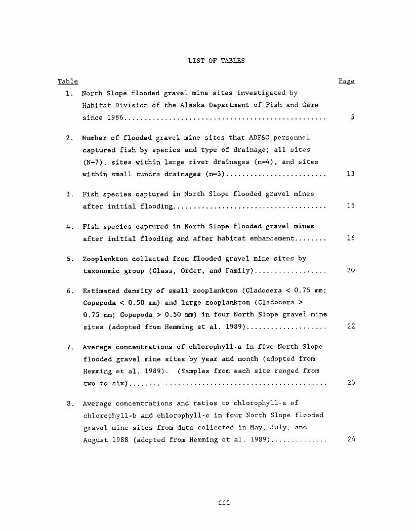
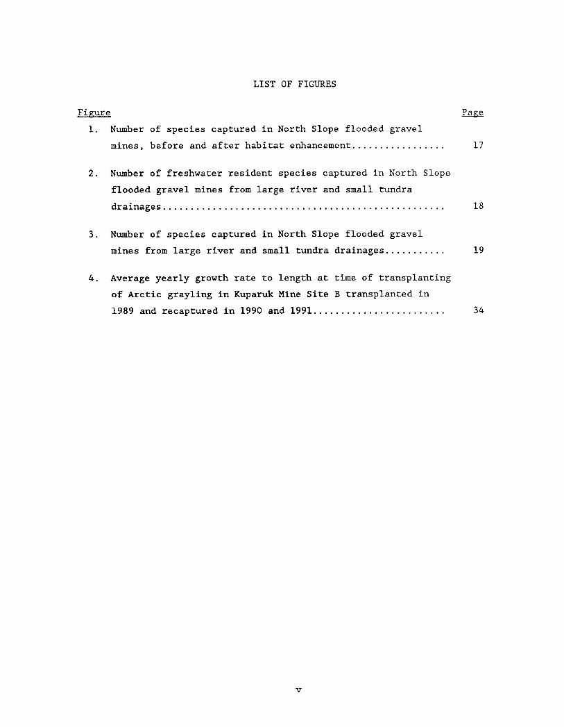
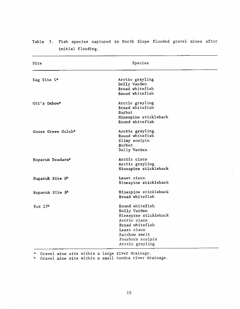
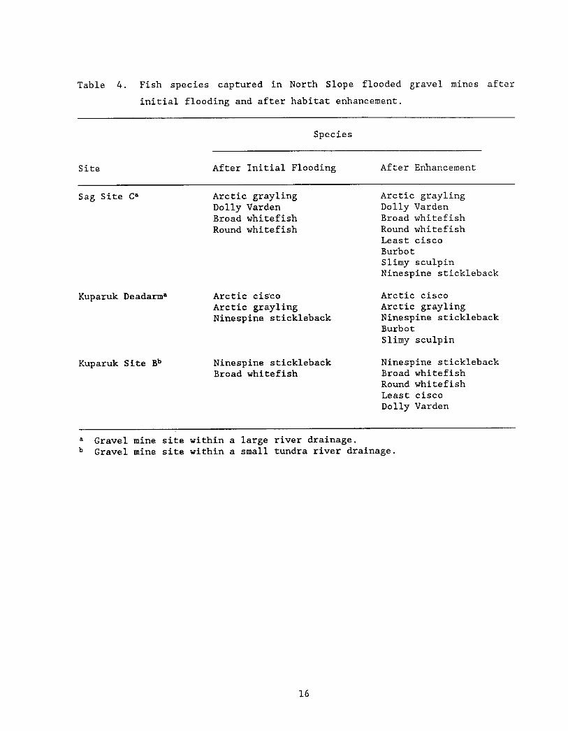
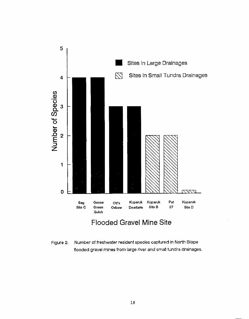
Sites In Large Drainages
Sites In Small Tundra Drainages
m Sag Goose 0~~~ Kuparuk Kuparuk Put Kuparuk
Site C Green Oxbow Dead- Site B 27 Site D Gulch
Flooded Gravel Mine Site
Figure 2 Number of freshwater resident species captured in North Slope
flooded gravel mines from large river and small tundra drainages
Sites In Large Drainages
Sites In Small Tundra Drainages
Sag Goose Ons Kuparuk Kuparuk Put Kuparuk Site C Green Oxbow Deadarm Site B 27 Site D
Gulch
Flooded Gravel Mine Site
Figure 3 Number of species captured in North Slope flooded gravel mines
from large river and small tundra drainages
Table 5 Zooplankton collected from flooded gravel mine sites by taxonomic
group (Class Order and Family)
Taxonomic Group
Site Class Order Family
Sag Site Ca
Kuparuk Deadarma
Kuparuk Site Db
Kuparuk Site Bb
Crus tacea Copepoda Cyclopodae
Diap tomidae
Temoridae
Insecta Coleoptera not identified
Diptera Chironomidae
Tabanidae
Tipulidae
Hymenop tera not identified
Trichoptera not identified
Crus tacea
Crus tacea
Cladocera Daphnidae
Copepoda Cyclopodae
Diaptomidae
Temoridae
Cladocera
Copepoda
Daphnidae
Cyclopodae
Diap tomidae
Cladocera
Copepoda
Crus tacea Daphnidae
Cyclopodae
Diaptomidae
Temoridae
Insecta Trichoptera not identified
Mollusca Gastropoda not identified
- --
a Gravel mine site within a large river drainage Gravel mine site within a small tundra river drainage
liter in Kuparuk Deadarm Mine Site in August Large Cladocera or large
Copepoda were not found in any of the sites in May Estimated densities of
small Copepoda and Cladocera ranged from zero organisms found in May in Sag
Site C to 50 to 75 organisms per litter in Kuparuk Mine Site D in August
(Table 6)
Phvtovlankton Surveys Hemming (1988) determined average chlorophyll-a
surface concentrations ranged from 128 to 551 pgL in four North Slope
flooded gravel mine sites in August 1987 (Table 7) Hemming et al (1989)
determined average chlorophyll-a concentrations at various depths ranged from
098 to 210 pgL in the four flooded mine sites in May July and August
1988 During May 1988 concentrations of chlorophyll-a ranged from 072 pgL
in Sag Mine Site C to 335 pgL in Kuparuk Mine Site D During July 1988
rilcentrations of chlorophyll-a ranged from 122 pgL in Kuparuk Deadarm Mine
Site to 276 pgL in Sag Mine Site C During August 1988 concentrations of
chlorophyll-a ranged from 079 pgL in Kuparuk Deadarm Mine Site to 275 pgL
in Kuparuk Mine Site B (Table 7) Additionally Hemming et al (1989)
determined average chlorophyll-b concentrations in the four flooded mine sites
in May July and August 1988 ranged from 014 pgL in Sag Mine Site C to 020
pgL in Kuparuk Mine Site D and average chlorophyll-c concentrations ranged
from 067 pgL in Kuparuk Deadarm Mine Site to 103 pgL in Kuparuk Mine Site
B (Table 8)
Chemical Evaluations Hemming (1988) and Hemming et al (1989) reported water
temperature profiles of North Slope flooded gravel mines isothermal during
April-May and August Kuparuk Deadarm Mine Site Kuparuk Mine Site D and
Kuparuk Mine Site B however were not isothermal in July Average water
temperatures during April-May ranged from 01 OC in Kuparuk Deadarm Mine Site
to 34 OC in Put 27 Mine Site average water temperatures during July ranged
from 36 OC in Sag Site C to 110 OC in Goose Green Gulch and average water
temperatures during August ranged from 70 OC in Put 27 lfine Site to 85 OC in
Kuparuk Site D Average DO during April-May ranged from 90 mgL in Kuparuk
Site B to 136 mgL in Kuparuk Deadarm Mine Site average DO during July
ranged from 93 mgL in Goose Green Gulch to 135 mgL in Sag Site C and
average DO during August ranged from 105 mgL in Put 27 Mine
Table 6 Estimated density of small zooplankton (Cladocera lt 0 75 mm
Copepoda lt 050 mm) and large zooplankton (Cladocera gt 0 75 mm
Copepoda gt 050 mm) in four North Slope gravel mine sites (adopted from Hemming et al 1989)
Number L -- - -
Small Zooplankton
Site May July Aug May July ug
Sag Site Ca 0 lt 1 lt 1 0 lt 1 lt 1
Kuparuk Deadarma 2-10 26-50 11-25 0 35 49
Kuparuk Site Db lt 1 11 - 25 50-75 0 lt 1 lt 1 Kuparuk Site Bb lt 1 2 - 10 26-50 0 lt 1 21
a Gravel mine site within a large river drainage Gravel mine site within a small tundra river drainage
Table 7 Average concentrations of chlorophyll-a in fiveC North Slope
flooded gravel mine sites by year and month (adopted from Hemming
et al 1989) (Samples from each site ranged from two to six)
Chlorophyll-a (pgL)
Site ug May July Aug Avg
Sag Site Ca 170
Kuparuk Deadarma 128
Kuparuk Site Db 551
iparuk Site Bb 159
a Gravel mine site w i t h i n a large river drainage Gravel mine site w i t h i n a small tundra river drainage Average concentration of chlorophyll-a in Goose Green Gulch in July 1990 was 027 (pgL)
Table 8 Average concentrations and ratios to chlorophyll-a of chlorophyll-b
and chlorophyll-c in four North Slope flooded gravel mine sites
from data collected in May July and August 1988 (adopted from
Hemming et al 1989)
Chlorophyll -b (pgL) Chlorophyll-c (pgL)
Site Concentration Ratio Concentration Ratio
Sag Site Ca 014 013
Kuparuk Deadarma 015 016
Kuparuk Site Db 020 007
Kuparuk Site Bb 015 011
a Gravel mine site within a large river drainage b Gravel mine site within a small tundra river drainage
Site to 113 mgL in Kuparuk Site D (Table 9)
Average pH ranged from 67 in Goose Green Gulch during July to 83 in Put 27
Mine Site during August Average conductivity ranged from 102 pScm in Sag
Site C during January-February to 894 pScm in Put 27 Mine Site during April-
May Average alkalinity ranged from 56 mgL in Kuparuk Site B during August
to 260 mgL in Put 27 during April-May Average hardness ranged from 64 mgL
in Kuparuk Site B during August to 194 mgL in Put 27 Mine Site during April-
May (Table 9)
Discussion
ADFampG studies indicate that fish species found in adjacent waterways will
mnlonize North Slope flooded gravel mine sites However connecting pathways
permanent or temporary are necessary for colonization Given the pathway
the number of species of fish utilizing flooded gravel mine sites are directly
related to the number of species occurring in the adjacent waterways (i e
colonization is limited to the number of available species) The number of
those species moving into flooded gravel mine sites furthermore are related
to the amount of time since initial flooding and the success of rehabilitation
efforts to provide overwintering or rearing habitat
The ADEM found that two or more species of fish colonized each North Slope
flooded gravel mine site investigated This represents a minimum number of
fish species It is likely that with increased effort or sampling at
different times of the year more species would be discovered ADFampG studies
indicated that flooded gravel mine sites within the large river drainages of
the Sag and Kuparuk Rivers are more likely colonized by freshwater fish
species than the flooded gravel mine sites found within small tundra
drainages Hemming (1988) suggested that the lack of overwintering habitat
within the small tundra drainages and in particular the inability of
obligatory freshwater fish to traverse saline waters to escape the poor winter
conditions may help to explain the absence of these fish in these systems
However it is believed that Arctic grayling could be self sustaining in these
small tundra streams if overwintering areas were available within these
Table 9 Average water temperature (temp) d isso lved oxygen (DO) a c i d i t y
(pH) conduct iv i ty (cond) a l k a l i n i t y ( a l k ) and hardness (hard)
va lues f o r North Slope flooded gravel mines by monthe and s i t e
Month S i t e Temp DO pH Cond AlkC HardC O C mgL pScm mgL mgL
January- February Sag S i t e Ca 09 108 75 102 9 0 8 8
April-May Sag S i t e Ca 1 0 12 6 77 105 8 6 9 9 Goose Green Gulcha - - - Kuparuk Deadarma 0 1 136 - - - Kuparuk S i t e Db 1 2 109 7 4 438 112 172 Kuparuk S i t e Bb 0 8 90 72 325 144 167 Put 27b 3 4 134 77 894 260 194
J u l y Sag S i t e Ca 36 135 - - Goose Green Gulcha 110 93 67 75 101 Kuparuk Deadarma 106d 118 - Kuparuk S i t e Db 51d 126 - - Kuparuk S i t e Bb 81d 111 - - Put 27b - - -
August Sag S i t e Ca 7 7 107 79 155 7 7 8 4 Goose Green Gulcha - - - - Kuparuk Deadarma - - - - Kuparuk S i t e Db 85 113 78 408 80 144 Kuparuk S i t e Bb 80 109 7 4 175 5 6 6 4 Put 2 7b 70 105 8 3 776 117 178
a Gravel mine s i t e wi th in a l a r g e r i v e r drainage Gravel mine s i t e wi th in a small tundra r i v e r drainage Expressed a s CaC03 Temperatures were no t isothermal Sag S i t e C sampled August 1986 January February A p r i l J u l y and August 1987 and May J u l y and August 1988 Goose Green Gulch sampled J u l y 1990 Kuparuk Deadarm sampled May J u l y and August 1988 Kuparuk S i t e D sampled August 1986 A p r i l J u l y and August 1987 May J u l y and August 1988 Kuparuk S i t e B sampled August 1986 Apr i l and J u l y 1987 May J u l y and August 1988 and May 1990 Put 27 Mine S i t e sampled May and August 1990
systems For example Arctic grayling are self sustaining in Weir Creek a
small tundra stream that flows into the Kavik River drainage (Craig and Poulin
1975) Deep water in the Kavik River provides overwintering habitat for these
fish However very little deep water is available to Arctic grayling in
small tundra systems that flow directly into the Beaufort Sea Flooded gravel
mine sites provide unique deep water habitat that may be used for
overwintering but it would be necessary to initially transplant Arctic
grayling or other desired species at these sites
The investigators found ninespine stickleback present in all flooded gravel
mine sites investigated and especially in the flooded gravel mine sites within
small tundra drainages with few other species This suggests that ninespine
stickleback are adapted to intermittent water flow and low oxygen conditions
lring the winter found in adjacent tundra waterways Hemming (1988)
attributes this to greater tolerance to low oxygen small size and high
reproductive rate of ninespine stickleback The effect of ninespine
stickleback on Arctic grayling is not known However Skaugstad (1989)
suggested that trophic competition between threespine stickleback Gasterosteus
aculeatus and Arctic grayling resulted in poor growth of Arctic grayling
fingerlings and no apparent survival of sac fry in Farmer and Sliver Lakes in
the interior of Alaska For this reason it may be necessary to transplant
Arctic grayling that are larger than the ninespine stickleback present in
these flooded gravel mine sites in order to establish an Arctic grayling
population Investigators found both Arctic grayling and ninespine
stickleback in Sag Site C Otts Oxbow Goose Green Gulch and Kuparuk Deadarm
mine sites This indicates that once established Arctic grayling
populations can exist in the same system with ninespine stickleback
All North Slope flooded gravel mine sites investigated contain sufficient
under-ice water during the winter to provide overwintering areas for fish
When compared to the shallowness of natural lakes and ponds on the North
Slope the flooded gravel mine sites have the potential to greatly increase
the amount of overwintering habitat for fish on the North Slope However
depth is only one characteristic to consider for overwintering habitat These
flooded gravel mine sites must also provide forage and escape cover for fish
that utilize these man-made lakes during the winter A gradual transition
from shallow water to deep water irregular shoreline development and the
strategic placement of islands would ensure that these needs are met by
providing increased shoreline vegetation that would extend into the under-ice
water
The greatest abundance and species richness of zooplankton were found in the
shallow areas of Kuparuk Deadann Mine Site and Kuparuk Mine Site B This
lends further support to the notion that littoral zones are important to
flooded gravel mine sites for providing zooplankton prey organisms for fish
However stomach analysis of fish captured at other sites also indicated the
presence of prey organisms but these organisms were mainly terrestrial
insects Littoral zones would likely increase the food-base within these
sites In addition over time as vegetation becomes more established in
flooded gravel mine sites the food-base will likely increase Artophilia
fulva may also be transplanted in shallow zones of these flooded mine sites to
help in establishing littoral vegetation Zooplankton similar to fish may
disperse into the flooded mine sites provided there are pathways for movement
Chlorophyll-a values found in the North Slope flooded gravel mine sites are
similar to values found in lakes and ponds near Yellowknife Northwest
Territories that support fish populations (Ostrofsky and Rigler 1987) Other
water bodies with similar chlorophyll-a values and populations of fish are
Charr Lake (high of 12 pgL and average of 08 pgL) Harding Lake (high of 4
pgL in May and average of 2 pgL during the summer months) and Toolik Lake
(13 pgL) (Kalff and Welch 1974 LaPerriere 1988 Hobbie et al 1986)
The North Slope flooded gravel mine sites investigated have suitable chemical
characteristics and dissolved oxygen levels to support fish Hemming (1988)
reported that the dissolved oxygen concentration in Sag Site C were at least
three times higher than that in known overwintering areas for fish in the Sag
River drainage Likewise Bendock (1980) reported dissolved oxygen
concentrations in several overwintering areas in the Colville River one-
third less than the dissolved oxygen concentrations found in the flooded
gravel mine sites studied
PART I1
ARCTIC GRAYLING TRANSPLANT INTO A SMALL TUNDRA DRAINAGE
Introduction
Considering the information gathered from fish zooplankton phytoplankton
and chemical surveys of North Slope flooded gravel mine sites ADFampG expect
that gravel mine sites within small tundra drainages may provide unique and
suitable rearing and overwintering habitat for fish not generally found in
these systems ADFG in 1989 determined the Kuparuk Mine Site B was
suitable for experimentally introducing Arctic grayling This mine site is
found within a small tundra drainage with little or no opportunity for
colonization by Arctic grayling Freshwater fish are prevented from entering
or leaving this small tundra system because of the marine saltwater barrier of
the Beaufort Sea Before 1989 only the anadromous ninespine stickleback
broad whitefish and least cisco were documented using this flooded gravel
mine site In addition Dolly Varden were documented using this site in 1991
Kuparuk Mine Site B is next to East Creek which drains directly into the
Beaufort Sea The Kuparuk Oil Pipeline and Spine Road borders Mine Site B on
the north This gravel mine site has two pits which when flooded in 1978
resulted in lakes totaling 37 ha (91 ac) In May 1989 ARCO Alaska Inc established an inlet channel and permanently connected the two lakes ARCO
Alaska personnel excavated a 18 m x 24 m section between East Creek and the
southern lake to a depth of 18 m to create an inlet channel Two additional
excavations of 14 m x 24 m between the two lakes connected the lakes and
formed an island (Hemming 1990)
In 1989 ADFampG conducted an experimental introduction of Arctic grayling from
the Sag River into Kuparuk Mine Site B to determine if Arctic grayling could
be introduced survive and establish a reproducing population over time
Hemming (1988) determined that this flooded gravel mine site holds sufficient
quantities of suitably oxygenated under-ice water for overwintering fish
Winters (1990b) suggested that the permanent connection between Kuparuk Mine
Site B and East Creek provides a pathway between the mine site and the stream
for fish movement that may provide access to rearing and spawning areas as a
source of additional nutrients to the mine site that may enhance productivity
and as a source of warmer water that may promote rapid ice melt during the
spring and warm the mine site during the summer
Methods
This section provides a brief summary of the methods used by ADFampG personnel
to capture and transplant Arctic grayling from the Sag River drainage to
Kuparuk Mine Site B Readers may obtain more in depth information on methods
from Winters (1990b) and Hemming (1991)
T n June 1989 A D F X personnel captured Arctic grayling from seven locations
within the Sag River drainage using fyke traps seines and hook and line
Arctic grayling were captured along the Sag River between Mark Creek and
Oksrukuyik Creek Each fish was measured to the nearest millimeter (fork
length) and scales removed for age analysis Numbered yellow floy tags were
attached at the base of the dorsal fin of each fish for individual
identification ADFM personnel released 210 Arctic grayling at the northeast
section of Kuparuk Mine Site D in June 1989 (Winters 1990b)
ADFampG personnel sampled Kuparuk Mine Site B in late August 1989 with fyke
traps and October 1989 by angling to determine if transplanted Arctic grayling
remained in the site Sampling also took place in June 1990 with fyke traps
and angling and in August and September 1990 with fyke traps to evaluate
survival growth and reproductive success of the transplanted Arctic
grayling The 1990 sampling event included sampling sites within East Creek
upstream and downstream of the mine site within the inlet channel to the mine
site and within the mine site Each fish captured was examined for the
presence of a floy tag or a tag scar and fork length measured (Winters 1990b)
ADFampG personnel conducted a mark-recapture experiment at Kuparuk Mine Site B
in 1991 to estimate Arctic grayling abundance in Kuparuk Mine Site B Arctic
grayling captured in June and July were marked with internal anchor floy tags
and adipose fin clipped The recapture event took place in August to allow
sufficient mixing Investigators used an adjusted Peterson calculation to
estimate the Arctic grayling abundance at the Kuparuk Mine Site B (Ricker
1975)
Results
Fork length of the Arctic grayling transplanted into Kuparuk Mine Site B
ranged from 176 to 399 mm with a mean of 283 mm and standard deviation of 52
mm The age of the Arctic grayling transplanted ranged from three to eleven
years Visual observation indicated that all transplanted Arctic grayling
were healthy at the time of release One Arctic grayling was observed moving
into East Creek and several were observed feeding within minutes of release
(Winters 1990b)
In 1989 investigators captured five Arctic grayling within the Kuparuk Mine
Site B two in fyke traps during August and three on hook and line during
October One fish captured in August was recaptured in October Four of
these fish were examined for the presence of a floy tag and length measured
All four fish were identified as transplanted fish three by floy tag and one
by tag scar These fish exhibited average daily growth from the time of
initial length measurements to recapture of 023 to 034 mm (Winters 1990b)
In 1990 investigators captured a total of 44 Arctic grayling within Kuparuk
Mine Site B within the inlet channel or within East Creek Thirty-six fish
(eight of the 44 fish were captured more than once) were examined for floy
tags and fork length measured Thirty-one of these fish were identified as
transplanted fish 16 by floy tag and 15 by tag scar These fish exhibited
average annual growth rates of 25 to 92 mrn with a mean of 586 mm During
June investigators captured 22 Arctic grayling with fyke traps three within
the inlet channel 13 upstream of the mine site six downstream of the mine
site In addition 18 Arctic grayling were captured on hook and line three
upstream of the mine site and fifteen within the mine site During August
investigators captured four Arctic grayling within the inlet channel with fyke
traps Although fyke traps were set and angling took place Arctic grayling
were not captured within the stream during the August event During
September investigators did not capture any Arctic grayling Three fyke
traps were set one within the inlet channel one at the north end of the
mining site and one upstream of the lake The effectiveness of these nets
was questionable and after 1-day of soaking had to be pulled because of
freezing in place (Hemming 1991)
In 1991 investigators captured a total of 79 Arctic grayling within Kuparuk
Mine Site B within the inlet channel or within East Creek Forty-three fish
(36 of the 79 fish were captured more than once) were examined for floy tags
and fork length measured Identified fish exhibited average annual growth
rates of 9 to 68 mm with a mean of 423 mm During June investigators
captured 21 Arctic grayling with fyke traps nine upstream of the mine site
gtlie downstream of the mine site and 11 within the mine site During July
investigators captured 25 Arctic grayling with fyke traps four within the
inlet channel two downstream of the mine site and 19 within the mine site
In addition nine Arctic grayling within the mine site and two within East
Creek were captured on hook and line During August investigators captured
22 Arctic grayling with fyke traps 19 within the inlet channel and 3
downstream of the mine site Five Arctic grayling captured in 1991 were
smaller than any of the fish transplanted at Kuparuk Mine Site B in 1989 Two
of these were estimated to be age-1 Arctic grayling (fork length = 120 mm and
115 mm) and three estimated to be young-of-the-year (fork length lt 38 mm)
In 1991 investigators estimated the abundance of Arctic grayling in and near
Kuparuk Mine Site B to be 56 fish (95 CI - 43 to 116 fish) in June and July Thirty-seven Arctic grayling were marked in June and July and 18 were captured
(12 with marks) in August Investigators estimated that 27 (95 CI - 20 to 55) of the original 210 Arctic grayling survived two years based on the
mark-recapture experiment
Discussion
ADFampG personnel successfully transplanted Arctic grayling in a North Slope
tundra drainage with few or no overwintering areas except for a rehabilitated
flooded gravel mine site Visual observation indicated that all transplanted
Arctic grayling were healthy at the time of release One Arctic grayling was
observed moving into East Creek and several were observed feeding within
minutes of release (Winters 1990b) At least 20 or possibly as high as 55
(95 CI) of the Arctic grayling transplanted at Kuparuk Mine Site B from the
Sag River drainage survived two years
Growth information indicated that these fish increased in length at a rate
comparable to age-2 to age-7 Arctic grayling in Weir Creek a small North
Slope tundra stream that drains into the Kavik River (Craig and Poulin 1975)
Craig and Poulin (1975) characterized the growth rate of Weir Creek Arctic
grayling as being among the highest for Arctic populations As expected fish
at a smaller size at the time of the transplant showed the greatest increase
in length (Figure 4)
Although reproductive success was not conclusive transplanted fish spawned
or were in pre-spawn condition in 1991 and five Arctic grayling were captured
near Kuparuk Mine Site B that were smaller than any of the fish originally
transplanted at the site Two of these fish were estimated to be age-1 Arctic
grayling (fork length - 120 mm and 115 mm) and three estimated to be young-of- the-year Arctic grayling (fork length lt 38 mm) The observed lengths of these
small Arctic grayling are consistent with the premise that they were the
spawning progeny of the transplanted fish
Length at Transplant (mm)
Figure 4 Average yearly growth rate to length at time of transplanting
of Arctic grayling in Kuparuk Mine Site B transplanted in 1989
and recaptured in 1 990 and 1991
ACKNOWLEDGEMENTS
This report is a synthesis of several Alaska Department of Fish and Game
Habitat and Restoration Division Technical Reports written by Carl Hemming
Phyllis Weber and Jack Winters Carl Hemming and Robert McLean provided
direction on content and manuscript review comments Funding was provided by
the Office of Ocean and Coastal Resource Management (OCRM) through a grant
administered by the Alaska Division of Government Coordination under the
federal OCRM Enhancement Grant Program Section 309
LITERATURE CITED
Bendock T N 1977 Beaufort Sea estuarine fishery study Pages 670-729 in
Alaskan OCS Principal Investigators Annual Reports Research Unit 233
NOAA United States Department of Commerce Boulder CO
Bendock T N 1980 Inventory and cataloging of arctic area waters Alaska
Department of Fish and Game Federal Aid in Fish Restoration Annual
Report of Progress 1978-1979 Project F-9-11 20(G-I-1)l-31
Bendock T N 1982 Inventory and cataloging of arctic area waters Alaska
Department of Fish and Game Federal Aid in Fish Restoration Annual
Report of Progress 1981-1982 Project F-9-14 23(G-I-1)l-43
Bendock T N and J M Burr 1984 Inventory and cataloging of arctic area
waters Alaska Department of Fish and Game Federal Aid in Fish
Restoration Annual Report of Progress 1983-1984 Project F-9-16
25(G-I-1)l-45
Bendock T N and J M Burr 1985 Inventory and cataloging of arctic area
waters Alaska Department of Fish and Game Federal Aid in Fish
Restoration Annual Report of Progress 1984-1985 Project F-9-17
26(G-I-1)l-40
Dew C B 1981 Kuparuk Field fish sunrey Final report by Woodward-Clyde
Consultants for ARC0 Alaska Inc Anchorage Alaska 15 pp
Craig P C and V A Poulin 1975 Movements and growth of Arctic
grayling (Thymallus arcticus) and juvenile Arctic char (Salvelinus
alpinus) in a small arctic stream Alaska Journal of the Fisheries
Research Board of Canada 32689-697
Hemming C R 1988 Aquatic habitat evaluation of flooded North Slope
gravel mine sites (1986-1987) Alaska Department of Fish and Game
Habitat Division Technical Report Number 88-1 Juneau 69 pp
LITERATURE CITED (Continued)
Hemming C R 1990 Fisheries investigations of flooded North Slope gravel
mine sites 1989 Alaska Department of Fish and Game Habitat Division
Technical Report Number 90-2 Juneau 38 pp
Hemming C R 1991 Fish and habitat investigations of flooded North Slope
gravel mines sites 1990 Alaska Department of Fish and Game Habitat
Division Technical Report Number 91-3 Juneau 44 pp
Hemming C R P K Weber and J F Winters 1989 Limnological and
fisheries investigations of flooded North Slope gravel mine sites 1988
Alaska Department of Fish and Game Habitat Division Technical Report
Number 89-1 Juneau 60 pp
Hobbie J E B J Peterson W B Bowden L Deegan A Hershey G
Kipphut M McDonald M Miller W J OfBrien 1986 Ecosystem
reactions to disturbance arctic streams and lakes Proposal for the
National science Foundation August 1986 220 pp
Joyce M R 1980 Effects of gravel removal on terrestrial biota Pages
215-271 in Gravel removal studies in arctic and subarctic floodplains in
Alaska Prepared by Woodward- Clyde Consultants for USFWS FWSOBS - 8008 403 pp
Joyce M R L A Rundquist and L L Moulton 1980 Gravel removal
guidelines manual for arctic and subarctic floodplains FWSOBS-8009
USD1USFWS 169 pp
Kalff J and H E Welch 1974 Phytoplankton production in Char Lake a
natural polar lake and in Meretta Lake a polluted polar lake
Cornwallis Islanb Northwest Territories Journal of the Fisheries
Research Board o f Canada 31621-636
LITERATURE CITED (Continued)
Klein D R 1973 The impact of oil development in the northern
environment Proceedings of the Interpetroleum Congress 3109-121
LaPerriere J D 1988 Associate Professor University of Alaska
personnel communication with Carl Hemming
Ostrofsky M L and F H Rigler 1987 Chlorophyll-phosphorus
relationships for subarctic lakes in western Canada Canadian Journal
of Fisheries and Aquatic Science 44775-781
Ricker W E 1975 Computation and interpretation of biological statistics
of fish populations Fisheries Research Board of Canada Bulletin No
191 382 pp
Schmidt D R W B Griffiths and L R Martin 1989 Overwintering
biology of anadromous fish in the Sagavanirktok River delta Alaska
Biological Papers of the University of Alaska 2455-74
Skaugstad C 1989 Evaluation of Arctic grayling enhancement a cost per
survivor estimate Alaska Department of Fish and Game Fishery Data
Series No 96 Juneau 68 pp
Weeden R B and D R Klein 1971 Wildlife and oil a survey of critical
issues in Alaska The Polar Record 15479-494
West G C 1976 Environmental problems associated with arctic development
especially in Alaska Environmental Conservation 3218-224
Winters J F 1990a Goose Green Gulch Fish and wildlife habitat in a
former gravel mine site Alaska Department of Fish and Game Habitat
Division Technical Report Number 90-1 Juneau 31 pp
LITERATURE CITED (Continued)
Winters J F 1990b A transplant of Arctic grayling to a flooded gravel
mine site in the Kuparuk River Oilfield Alaska Department of Fish and
Game Habitat Division Technical Report Number 90-4 Juneau 26 pp
Woodward-Clyde Consultants 1980 Gravel removal studies in arctic and
subarctic floodplains in Alaska FWSOBS - 8008 403 pp
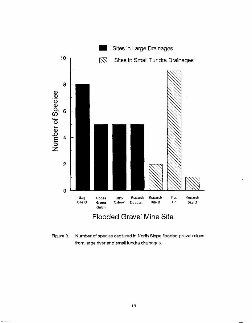
Sites In Large Drainages
Sites In Small Tundra Drainages
Sag Goose Ons Kuparuk Kuparuk Put Kuparuk Site C Green Oxbow Deadarm Site B 27 Site D
Gulch
Flooded Gravel Mine Site
Figure 3 Number of species captured in North Slope flooded gravel mines
from large river and small tundra drainages
Table 5 Zooplankton collected from flooded gravel mine sites by taxonomic
group (Class Order and Family)
Taxonomic Group
Site Class Order Family
Sag Site Ca
Kuparuk Deadarma
Kuparuk Site Db
Kuparuk Site Bb
Crus tacea Copepoda Cyclopodae
Diap tomidae
Temoridae
Insecta Coleoptera not identified
Diptera Chironomidae
Tabanidae
Tipulidae
Hymenop tera not identified
Trichoptera not identified
Crus tacea
Crus tacea
Cladocera Daphnidae
Copepoda Cyclopodae
Diaptomidae
Temoridae
Cladocera
Copepoda
Daphnidae
Cyclopodae
Diap tomidae
Cladocera
Copepoda
Crus tacea Daphnidae
Cyclopodae
Diaptomidae
Temoridae
Insecta Trichoptera not identified
Mollusca Gastropoda not identified
- --
a Gravel mine site within a large river drainage Gravel mine site within a small tundra river drainage
liter in Kuparuk Deadarm Mine Site in August Large Cladocera or large
Copepoda were not found in any of the sites in May Estimated densities of
small Copepoda and Cladocera ranged from zero organisms found in May in Sag
Site C to 50 to 75 organisms per litter in Kuparuk Mine Site D in August
(Table 6)
Phvtovlankton Surveys Hemming (1988) determined average chlorophyll-a
surface concentrations ranged from 128 to 551 pgL in four North Slope
flooded gravel mine sites in August 1987 (Table 7) Hemming et al (1989)
determined average chlorophyll-a concentrations at various depths ranged from
098 to 210 pgL in the four flooded mine sites in May July and August
1988 During May 1988 concentrations of chlorophyll-a ranged from 072 pgL
in Sag Mine Site C to 335 pgL in Kuparuk Mine Site D During July 1988
rilcentrations of chlorophyll-a ranged from 122 pgL in Kuparuk Deadarm Mine
Site to 276 pgL in Sag Mine Site C During August 1988 concentrations of
chlorophyll-a ranged from 079 pgL in Kuparuk Deadarm Mine Site to 275 pgL
in Kuparuk Mine Site B (Table 7) Additionally Hemming et al (1989)
determined average chlorophyll-b concentrations in the four flooded mine sites
in May July and August 1988 ranged from 014 pgL in Sag Mine Site C to 020
pgL in Kuparuk Mine Site D and average chlorophyll-c concentrations ranged
from 067 pgL in Kuparuk Deadarm Mine Site to 103 pgL in Kuparuk Mine Site
B (Table 8)
Chemical Evaluations Hemming (1988) and Hemming et al (1989) reported water
temperature profiles of North Slope flooded gravel mines isothermal during
April-May and August Kuparuk Deadarm Mine Site Kuparuk Mine Site D and
Kuparuk Mine Site B however were not isothermal in July Average water
temperatures during April-May ranged from 01 OC in Kuparuk Deadarm Mine Site
to 34 OC in Put 27 Mine Site average water temperatures during July ranged
from 36 OC in Sag Site C to 110 OC in Goose Green Gulch and average water
temperatures during August ranged from 70 OC in Put 27 lfine Site to 85 OC in
Kuparuk Site D Average DO during April-May ranged from 90 mgL in Kuparuk
Site B to 136 mgL in Kuparuk Deadarm Mine Site average DO during July
ranged from 93 mgL in Goose Green Gulch to 135 mgL in Sag Site C and
average DO during August ranged from 105 mgL in Put 27 Mine
Table 6 Estimated density of small zooplankton (Cladocera lt 0 75 mm
Copepoda lt 050 mm) and large zooplankton (Cladocera gt 0 75 mm
Copepoda gt 050 mm) in four North Slope gravel mine sites (adopted from Hemming et al 1989)
Number L -- - -
Small Zooplankton
Site May July Aug May July ug
Sag Site Ca 0 lt 1 lt 1 0 lt 1 lt 1
Kuparuk Deadarma 2-10 26-50 11-25 0 35 49
Kuparuk Site Db lt 1 11 - 25 50-75 0 lt 1 lt 1 Kuparuk Site Bb lt 1 2 - 10 26-50 0 lt 1 21
a Gravel mine site within a large river drainage Gravel mine site within a small tundra river drainage
Table 7 Average concentrations of chlorophyll-a in fiveC North Slope
flooded gravel mine sites by year and month (adopted from Hemming
et al 1989) (Samples from each site ranged from two to six)
Chlorophyll-a (pgL)
Site ug May July Aug Avg
Sag Site Ca 170
Kuparuk Deadarma 128
Kuparuk Site Db 551
iparuk Site Bb 159
a Gravel mine site w i t h i n a large river drainage Gravel mine site w i t h i n a small tundra river drainage Average concentration of chlorophyll-a in Goose Green Gulch in July 1990 was 027 (pgL)
Table 8 Average concentrations and ratios to chlorophyll-a of chlorophyll-b
and chlorophyll-c in four North Slope flooded gravel mine sites
from data collected in May July and August 1988 (adopted from
Hemming et al 1989)
Chlorophyll -b (pgL) Chlorophyll-c (pgL)
Site Concentration Ratio Concentration Ratio
Sag Site Ca 014 013
Kuparuk Deadarma 015 016
Kuparuk Site Db 020 007
Kuparuk Site Bb 015 011
a Gravel mine site within a large river drainage b Gravel mine site within a small tundra river drainage
Site to 113 mgL in Kuparuk Site D (Table 9)
Average pH ranged from 67 in Goose Green Gulch during July to 83 in Put 27
Mine Site during August Average conductivity ranged from 102 pScm in Sag
Site C during January-February to 894 pScm in Put 27 Mine Site during April-
May Average alkalinity ranged from 56 mgL in Kuparuk Site B during August
to 260 mgL in Put 27 during April-May Average hardness ranged from 64 mgL
in Kuparuk Site B during August to 194 mgL in Put 27 Mine Site during April-
May (Table 9)
Discussion
ADFampG studies indicate that fish species found in adjacent waterways will
mnlonize North Slope flooded gravel mine sites However connecting pathways
permanent or temporary are necessary for colonization Given the pathway
the number of species of fish utilizing flooded gravel mine sites are directly
related to the number of species occurring in the adjacent waterways (i e
colonization is limited to the number of available species) The number of
those species moving into flooded gravel mine sites furthermore are related
to the amount of time since initial flooding and the success of rehabilitation
efforts to provide overwintering or rearing habitat
The ADEM found that two or more species of fish colonized each North Slope
flooded gravel mine site investigated This represents a minimum number of
fish species It is likely that with increased effort or sampling at
different times of the year more species would be discovered ADFampG studies
indicated that flooded gravel mine sites within the large river drainages of
the Sag and Kuparuk Rivers are more likely colonized by freshwater fish
species than the flooded gravel mine sites found within small tundra
drainages Hemming (1988) suggested that the lack of overwintering habitat
within the small tundra drainages and in particular the inability of
obligatory freshwater fish to traverse saline waters to escape the poor winter
conditions may help to explain the absence of these fish in these systems
However it is believed that Arctic grayling could be self sustaining in these
small tundra streams if overwintering areas were available within these
Table 9 Average water temperature (temp) d isso lved oxygen (DO) a c i d i t y
(pH) conduct iv i ty (cond) a l k a l i n i t y ( a l k ) and hardness (hard)
va lues f o r North Slope flooded gravel mines by monthe and s i t e
Month S i t e Temp DO pH Cond AlkC HardC O C mgL pScm mgL mgL
January- February Sag S i t e Ca 09 108 75 102 9 0 8 8
April-May Sag S i t e Ca 1 0 12 6 77 105 8 6 9 9 Goose Green Gulcha - - - Kuparuk Deadarma 0 1 136 - - - Kuparuk S i t e Db 1 2 109 7 4 438 112 172 Kuparuk S i t e Bb 0 8 90 72 325 144 167 Put 27b 3 4 134 77 894 260 194
J u l y Sag S i t e Ca 36 135 - - Goose Green Gulcha 110 93 67 75 101 Kuparuk Deadarma 106d 118 - Kuparuk S i t e Db 51d 126 - - Kuparuk S i t e Bb 81d 111 - - Put 27b - - -
August Sag S i t e Ca 7 7 107 79 155 7 7 8 4 Goose Green Gulcha - - - - Kuparuk Deadarma - - - - Kuparuk S i t e Db 85 113 78 408 80 144 Kuparuk S i t e Bb 80 109 7 4 175 5 6 6 4 Put 2 7b 70 105 8 3 776 117 178
a Gravel mine s i t e wi th in a l a r g e r i v e r drainage Gravel mine s i t e wi th in a small tundra r i v e r drainage Expressed a s CaC03 Temperatures were no t isothermal Sag S i t e C sampled August 1986 January February A p r i l J u l y and August 1987 and May J u l y and August 1988 Goose Green Gulch sampled J u l y 1990 Kuparuk Deadarm sampled May J u l y and August 1988 Kuparuk S i t e D sampled August 1986 A p r i l J u l y and August 1987 May J u l y and August 1988 Kuparuk S i t e B sampled August 1986 Apr i l and J u l y 1987 May J u l y and August 1988 and May 1990 Put 27 Mine S i t e sampled May and August 1990
systems For example Arctic grayling are self sustaining in Weir Creek a
small tundra stream that flows into the Kavik River drainage (Craig and Poulin
1975) Deep water in the Kavik River provides overwintering habitat for these
fish However very little deep water is available to Arctic grayling in
small tundra systems that flow directly into the Beaufort Sea Flooded gravel
mine sites provide unique deep water habitat that may be used for
overwintering but it would be necessary to initially transplant Arctic
grayling or other desired species at these sites
The investigators found ninespine stickleback present in all flooded gravel
mine sites investigated and especially in the flooded gravel mine sites within
small tundra drainages with few other species This suggests that ninespine
stickleback are adapted to intermittent water flow and low oxygen conditions
lring the winter found in adjacent tundra waterways Hemming (1988)
attributes this to greater tolerance to low oxygen small size and high
reproductive rate of ninespine stickleback The effect of ninespine
stickleback on Arctic grayling is not known However Skaugstad (1989)
suggested that trophic competition between threespine stickleback Gasterosteus
aculeatus and Arctic grayling resulted in poor growth of Arctic grayling
fingerlings and no apparent survival of sac fry in Farmer and Sliver Lakes in
the interior of Alaska For this reason it may be necessary to transplant
Arctic grayling that are larger than the ninespine stickleback present in
these flooded gravel mine sites in order to establish an Arctic grayling
population Investigators found both Arctic grayling and ninespine
stickleback in Sag Site C Otts Oxbow Goose Green Gulch and Kuparuk Deadarm
mine sites This indicates that once established Arctic grayling
populations can exist in the same system with ninespine stickleback
All North Slope flooded gravel mine sites investigated contain sufficient
under-ice water during the winter to provide overwintering areas for fish
When compared to the shallowness of natural lakes and ponds on the North
Slope the flooded gravel mine sites have the potential to greatly increase
the amount of overwintering habitat for fish on the North Slope However
depth is only one characteristic to consider for overwintering habitat These
flooded gravel mine sites must also provide forage and escape cover for fish
that utilize these man-made lakes during the winter A gradual transition
from shallow water to deep water irregular shoreline development and the
strategic placement of islands would ensure that these needs are met by
providing increased shoreline vegetation that would extend into the under-ice
water
The greatest abundance and species richness of zooplankton were found in the
shallow areas of Kuparuk Deadann Mine Site and Kuparuk Mine Site B This
lends further support to the notion that littoral zones are important to
flooded gravel mine sites for providing zooplankton prey organisms for fish
However stomach analysis of fish captured at other sites also indicated the
presence of prey organisms but these organisms were mainly terrestrial
insects Littoral zones would likely increase the food-base within these
sites In addition over time as vegetation becomes more established in
flooded gravel mine sites the food-base will likely increase Artophilia
fulva may also be transplanted in shallow zones of these flooded mine sites to
help in establishing littoral vegetation Zooplankton similar to fish may
disperse into the flooded mine sites provided there are pathways for movement
Chlorophyll-a values found in the North Slope flooded gravel mine sites are
similar to values found in lakes and ponds near Yellowknife Northwest
Territories that support fish populations (Ostrofsky and Rigler 1987) Other
water bodies with similar chlorophyll-a values and populations of fish are
Charr Lake (high of 12 pgL and average of 08 pgL) Harding Lake (high of 4
pgL in May and average of 2 pgL during the summer months) and Toolik Lake
(13 pgL) (Kalff and Welch 1974 LaPerriere 1988 Hobbie et al 1986)
The North Slope flooded gravel mine sites investigated have suitable chemical
characteristics and dissolved oxygen levels to support fish Hemming (1988)
reported that the dissolved oxygen concentration in Sag Site C were at least
three times higher than that in known overwintering areas for fish in the Sag
River drainage Likewise Bendock (1980) reported dissolved oxygen
concentrations in several overwintering areas in the Colville River one-
third less than the dissolved oxygen concentrations found in the flooded
gravel mine sites studied
PART I1
ARCTIC GRAYLING TRANSPLANT INTO A SMALL TUNDRA DRAINAGE
Introduction
Considering the information gathered from fish zooplankton phytoplankton
and chemical surveys of North Slope flooded gravel mine sites ADFampG expect
that gravel mine sites within small tundra drainages may provide unique and
suitable rearing and overwintering habitat for fish not generally found in
these systems ADFG in 1989 determined the Kuparuk Mine Site B was
suitable for experimentally introducing Arctic grayling This mine site is
found within a small tundra drainage with little or no opportunity for
colonization by Arctic grayling Freshwater fish are prevented from entering
or leaving this small tundra system because of the marine saltwater barrier of
the Beaufort Sea Before 1989 only the anadromous ninespine stickleback
broad whitefish and least cisco were documented using this flooded gravel
mine site In addition Dolly Varden were documented using this site in 1991
Kuparuk Mine Site B is next to East Creek which drains directly into the
Beaufort Sea The Kuparuk Oil Pipeline and Spine Road borders Mine Site B on
the north This gravel mine site has two pits which when flooded in 1978
resulted in lakes totaling 37 ha (91 ac) In May 1989 ARCO Alaska Inc established an inlet channel and permanently connected the two lakes ARCO
Alaska personnel excavated a 18 m x 24 m section between East Creek and the
southern lake to a depth of 18 m to create an inlet channel Two additional
excavations of 14 m x 24 m between the two lakes connected the lakes and
formed an island (Hemming 1990)
In 1989 ADFampG conducted an experimental introduction of Arctic grayling from
the Sag River into Kuparuk Mine Site B to determine if Arctic grayling could
be introduced survive and establish a reproducing population over time
Hemming (1988) determined that this flooded gravel mine site holds sufficient
quantities of suitably oxygenated under-ice water for overwintering fish
Winters (1990b) suggested that the permanent connection between Kuparuk Mine
Site B and East Creek provides a pathway between the mine site and the stream
for fish movement that may provide access to rearing and spawning areas as a
source of additional nutrients to the mine site that may enhance productivity
and as a source of warmer water that may promote rapid ice melt during the
spring and warm the mine site during the summer
Methods
This section provides a brief summary of the methods used by ADFampG personnel
to capture and transplant Arctic grayling from the Sag River drainage to
Kuparuk Mine Site B Readers may obtain more in depth information on methods
from Winters (1990b) and Hemming (1991)
T n June 1989 A D F X personnel captured Arctic grayling from seven locations
within the Sag River drainage using fyke traps seines and hook and line
Arctic grayling were captured along the Sag River between Mark Creek and
Oksrukuyik Creek Each fish was measured to the nearest millimeter (fork
length) and scales removed for age analysis Numbered yellow floy tags were
attached at the base of the dorsal fin of each fish for individual
identification ADFM personnel released 210 Arctic grayling at the northeast
section of Kuparuk Mine Site D in June 1989 (Winters 1990b)
ADFampG personnel sampled Kuparuk Mine Site B in late August 1989 with fyke
traps and October 1989 by angling to determine if transplanted Arctic grayling
remained in the site Sampling also took place in June 1990 with fyke traps
and angling and in August and September 1990 with fyke traps to evaluate
survival growth and reproductive success of the transplanted Arctic
grayling The 1990 sampling event included sampling sites within East Creek
upstream and downstream of the mine site within the inlet channel to the mine
site and within the mine site Each fish captured was examined for the
presence of a floy tag or a tag scar and fork length measured (Winters 1990b)
ADFampG personnel conducted a mark-recapture experiment at Kuparuk Mine Site B
in 1991 to estimate Arctic grayling abundance in Kuparuk Mine Site B Arctic
grayling captured in June and July were marked with internal anchor floy tags
and adipose fin clipped The recapture event took place in August to allow
sufficient mixing Investigators used an adjusted Peterson calculation to
estimate the Arctic grayling abundance at the Kuparuk Mine Site B (Ricker
1975)
Results
Fork length of the Arctic grayling transplanted into Kuparuk Mine Site B
ranged from 176 to 399 mm with a mean of 283 mm and standard deviation of 52
mm The age of the Arctic grayling transplanted ranged from three to eleven
years Visual observation indicated that all transplanted Arctic grayling
were healthy at the time of release One Arctic grayling was observed moving
into East Creek and several were observed feeding within minutes of release
(Winters 1990b)
In 1989 investigators captured five Arctic grayling within the Kuparuk Mine
Site B two in fyke traps during August and three on hook and line during
October One fish captured in August was recaptured in October Four of
these fish were examined for the presence of a floy tag and length measured
All four fish were identified as transplanted fish three by floy tag and one
by tag scar These fish exhibited average daily growth from the time of
initial length measurements to recapture of 023 to 034 mm (Winters 1990b)
In 1990 investigators captured a total of 44 Arctic grayling within Kuparuk
Mine Site B within the inlet channel or within East Creek Thirty-six fish
(eight of the 44 fish were captured more than once) were examined for floy
tags and fork length measured Thirty-one of these fish were identified as
transplanted fish 16 by floy tag and 15 by tag scar These fish exhibited
average annual growth rates of 25 to 92 mrn with a mean of 586 mm During
June investigators captured 22 Arctic grayling with fyke traps three within
the inlet channel 13 upstream of the mine site six downstream of the mine
site In addition 18 Arctic grayling were captured on hook and line three
upstream of the mine site and fifteen within the mine site During August
investigators captured four Arctic grayling within the inlet channel with fyke
traps Although fyke traps were set and angling took place Arctic grayling
were not captured within the stream during the August event During
September investigators did not capture any Arctic grayling Three fyke
traps were set one within the inlet channel one at the north end of the
mining site and one upstream of the lake The effectiveness of these nets
was questionable and after 1-day of soaking had to be pulled because of
freezing in place (Hemming 1991)
In 1991 investigators captured a total of 79 Arctic grayling within Kuparuk
Mine Site B within the inlet channel or within East Creek Forty-three fish
(36 of the 79 fish were captured more than once) were examined for floy tags
and fork length measured Identified fish exhibited average annual growth
rates of 9 to 68 mm with a mean of 423 mm During June investigators
captured 21 Arctic grayling with fyke traps nine upstream of the mine site
gtlie downstream of the mine site and 11 within the mine site During July
investigators captured 25 Arctic grayling with fyke traps four within the
inlet channel two downstream of the mine site and 19 within the mine site
In addition nine Arctic grayling within the mine site and two within East
Creek were captured on hook and line During August investigators captured
22 Arctic grayling with fyke traps 19 within the inlet channel and 3
downstream of the mine site Five Arctic grayling captured in 1991 were
smaller than any of the fish transplanted at Kuparuk Mine Site B in 1989 Two
of these were estimated to be age-1 Arctic grayling (fork length = 120 mm and
115 mm) and three estimated to be young-of-the-year (fork length lt 38 mm)
In 1991 investigators estimated the abundance of Arctic grayling in and near
Kuparuk Mine Site B to be 56 fish (95 CI - 43 to 116 fish) in June and July Thirty-seven Arctic grayling were marked in June and July and 18 were captured
(12 with marks) in August Investigators estimated that 27 (95 CI - 20 to 55) of the original 210 Arctic grayling survived two years based on the
mark-recapture experiment
Discussion
ADFampG personnel successfully transplanted Arctic grayling in a North Slope
tundra drainage with few or no overwintering areas except for a rehabilitated
flooded gravel mine site Visual observation indicated that all transplanted
Arctic grayling were healthy at the time of release One Arctic grayling was
observed moving into East Creek and several were observed feeding within
minutes of release (Winters 1990b) At least 20 or possibly as high as 55
(95 CI) of the Arctic grayling transplanted at Kuparuk Mine Site B from the
Sag River drainage survived two years
Growth information indicated that these fish increased in length at a rate
comparable to age-2 to age-7 Arctic grayling in Weir Creek a small North
Slope tundra stream that drains into the Kavik River (Craig and Poulin 1975)
Craig and Poulin (1975) characterized the growth rate of Weir Creek Arctic
grayling as being among the highest for Arctic populations As expected fish
at a smaller size at the time of the transplant showed the greatest increase
in length (Figure 4)
Although reproductive success was not conclusive transplanted fish spawned
or were in pre-spawn condition in 1991 and five Arctic grayling were captured
near Kuparuk Mine Site B that were smaller than any of the fish originally
transplanted at the site Two of these fish were estimated to be age-1 Arctic
grayling (fork length - 120 mm and 115 mm) and three estimated to be young-of- the-year Arctic grayling (fork length lt 38 mm) The observed lengths of these
small Arctic grayling are consistent with the premise that they were the
spawning progeny of the transplanted fish
Length at Transplant (mm)
Figure 4 Average yearly growth rate to length at time of transplanting
of Arctic grayling in Kuparuk Mine Site B transplanted in 1989
and recaptured in 1 990 and 1991
ACKNOWLEDGEMENTS
This report is a synthesis of several Alaska Department of Fish and Game
Habitat and Restoration Division Technical Reports written by Carl Hemming
Phyllis Weber and Jack Winters Carl Hemming and Robert McLean provided
direction on content and manuscript review comments Funding was provided by
the Office of Ocean and Coastal Resource Management (OCRM) through a grant
administered by the Alaska Division of Government Coordination under the
federal OCRM Enhancement Grant Program Section 309
LITERATURE CITED
Bendock T N 1977 Beaufort Sea estuarine fishery study Pages 670-729 in
Alaskan OCS Principal Investigators Annual Reports Research Unit 233
NOAA United States Department of Commerce Boulder CO
Bendock T N 1980 Inventory and cataloging of arctic area waters Alaska
Department of Fish and Game Federal Aid in Fish Restoration Annual
Report of Progress 1978-1979 Project F-9-11 20(G-I-1)l-31
Bendock T N 1982 Inventory and cataloging of arctic area waters Alaska
Department of Fish and Game Federal Aid in Fish Restoration Annual
Report of Progress 1981-1982 Project F-9-14 23(G-I-1)l-43
Bendock T N and J M Burr 1984 Inventory and cataloging of arctic area
waters Alaska Department of Fish and Game Federal Aid in Fish
Restoration Annual Report of Progress 1983-1984 Project F-9-16
25(G-I-1)l-45
Bendock T N and J M Burr 1985 Inventory and cataloging of arctic area
waters Alaska Department of Fish and Game Federal Aid in Fish
Restoration Annual Report of Progress 1984-1985 Project F-9-17
26(G-I-1)l-40
Dew C B 1981 Kuparuk Field fish sunrey Final report by Woodward-Clyde
Consultants for ARC0 Alaska Inc Anchorage Alaska 15 pp
Craig P C and V A Poulin 1975 Movements and growth of Arctic
grayling (Thymallus arcticus) and juvenile Arctic char (Salvelinus
alpinus) in a small arctic stream Alaska Journal of the Fisheries
Research Board of Canada 32689-697
Hemming C R 1988 Aquatic habitat evaluation of flooded North Slope
gravel mine sites (1986-1987) Alaska Department of Fish and Game
Habitat Division Technical Report Number 88-1 Juneau 69 pp
LITERATURE CITED (Continued)
Hemming C R 1990 Fisheries investigations of flooded North Slope gravel
mine sites 1989 Alaska Department of Fish and Game Habitat Division
Technical Report Number 90-2 Juneau 38 pp
Hemming C R 1991 Fish and habitat investigations of flooded North Slope
gravel mines sites 1990 Alaska Department of Fish and Game Habitat
Division Technical Report Number 91-3 Juneau 44 pp
Hemming C R P K Weber and J F Winters 1989 Limnological and
fisheries investigations of flooded North Slope gravel mine sites 1988
Alaska Department of Fish and Game Habitat Division Technical Report
Number 89-1 Juneau 60 pp
Hobbie J E B J Peterson W B Bowden L Deegan A Hershey G
Kipphut M McDonald M Miller W J OfBrien 1986 Ecosystem
reactions to disturbance arctic streams and lakes Proposal for the
National science Foundation August 1986 220 pp
Joyce M R 1980 Effects of gravel removal on terrestrial biota Pages
215-271 in Gravel removal studies in arctic and subarctic floodplains in
Alaska Prepared by Woodward- Clyde Consultants for USFWS FWSOBS - 8008 403 pp
Joyce M R L A Rundquist and L L Moulton 1980 Gravel removal
guidelines manual for arctic and subarctic floodplains FWSOBS-8009
USD1USFWS 169 pp
Kalff J and H E Welch 1974 Phytoplankton production in Char Lake a
natural polar lake and in Meretta Lake a polluted polar lake
Cornwallis Islanb Northwest Territories Journal of the Fisheries
Research Board o f Canada 31621-636
LITERATURE CITED (Continued)
Klein D R 1973 The impact of oil development in the northern
environment Proceedings of the Interpetroleum Congress 3109-121
LaPerriere J D 1988 Associate Professor University of Alaska
personnel communication with Carl Hemming
Ostrofsky M L and F H Rigler 1987 Chlorophyll-phosphorus
relationships for subarctic lakes in western Canada Canadian Journal
of Fisheries and Aquatic Science 44775-781
Ricker W E 1975 Computation and interpretation of biological statistics
of fish populations Fisheries Research Board of Canada Bulletin No
191 382 pp
Schmidt D R W B Griffiths and L R Martin 1989 Overwintering
biology of anadromous fish in the Sagavanirktok River delta Alaska
Biological Papers of the University of Alaska 2455-74
Skaugstad C 1989 Evaluation of Arctic grayling enhancement a cost per
survivor estimate Alaska Department of Fish and Game Fishery Data
Series No 96 Juneau 68 pp
Weeden R B and D R Klein 1971 Wildlife and oil a survey of critical
issues in Alaska The Polar Record 15479-494
West G C 1976 Environmental problems associated with arctic development
especially in Alaska Environmental Conservation 3218-224
Winters J F 1990a Goose Green Gulch Fish and wildlife habitat in a
former gravel mine site Alaska Department of Fish and Game Habitat
Division Technical Report Number 90-1 Juneau 31 pp
LITERATURE CITED (Continued)
Winters J F 1990b A transplant of Arctic grayling to a flooded gravel
mine site in the Kuparuk River Oilfield Alaska Department of Fish and
Game Habitat Division Technical Report Number 90-4 Juneau 26 pp
Woodward-Clyde Consultants 1980 Gravel removal studies in arctic and
subarctic floodplains in Alaska FWSOBS - 8008 403 pp
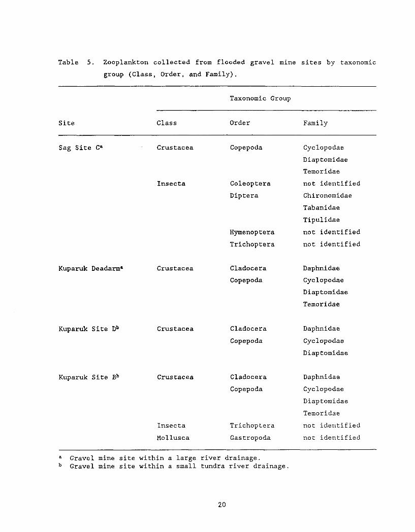
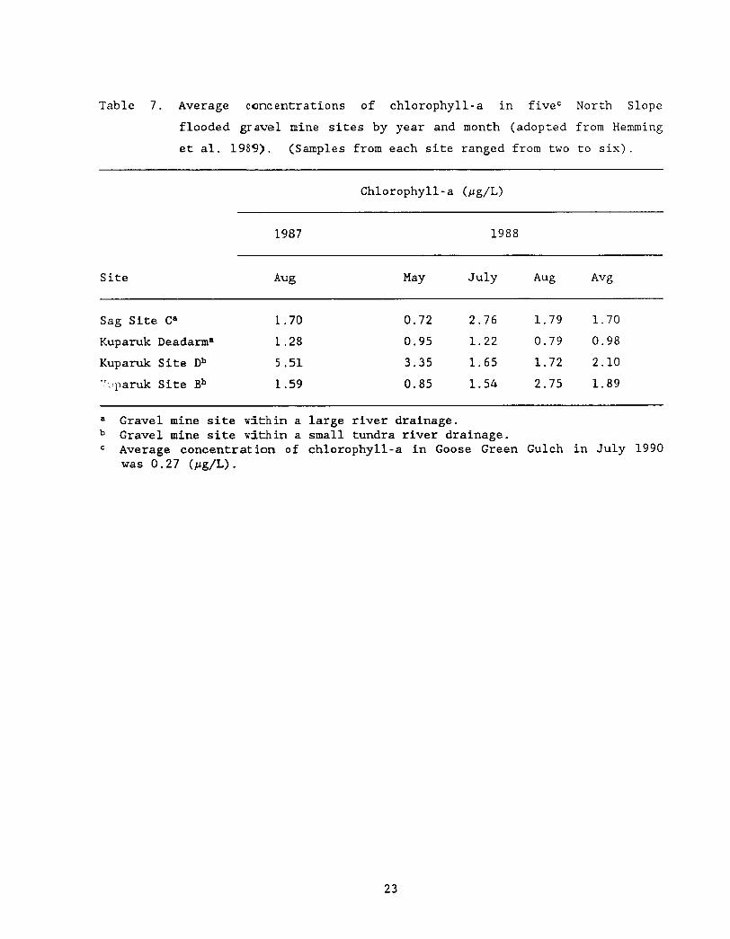
LITERATURE CITED (Continued)
Hemming C R 1990 Fisheries investigations of flooded North Slope gravel
mine sites 1989 Alaska Department of Fish and Game Habitat Division
Technical Report Number 90-2 Juneau 38 pp
Hemming C R 1991 Fish and habitat investigations of flooded North Slope
gravel mines sites 1990 Alaska Department of Fish and Game Habitat
Division Technical Report Number 91-3 Juneau 44 pp
Hemming C R P K Weber and J F Winters 1989 Limnological and
fisheries investigations of flooded North Slope gravel mine sites 1988
Alaska Department of Fish and Game Habitat Division Technical Report
Number 89-1 Juneau 60 pp
Hobbie J E B J Peterson W B Bowden L Deegan A Hershey G
Kipphut M McDonald M Miller W J OfBrien 1986 Ecosystem
reactions to disturbance arctic streams and lakes Proposal for the
National science Foundation August 1986 220 pp
Joyce M R 1980 Effects of gravel removal on terrestrial biota Pages
215-271 in Gravel removal studies in arctic and subarctic floodplains in
Alaska Prepared by Woodward- Clyde Consultants for USFWS FWSOBS - 8008 403 pp
Joyce M R L A Rundquist and L L Moulton 1980 Gravel removal
guidelines manual for arctic and subarctic floodplains FWSOBS-8009
USD1USFWS 169 pp
Kalff J and H E Welch 1974 Phytoplankton production in Char Lake a
natural polar lake and in Meretta Lake a polluted polar lake
Cornwallis Islanb Northwest Territories Journal of the Fisheries
Research Board o f Canada 31621-636
LITERATURE CITED (Continued)
Klein D R 1973 The impact of oil development in the northern
environment Proceedings of the Interpetroleum Congress 3109-121
LaPerriere J D 1988 Associate Professor University of Alaska
personnel communication with Carl Hemming
Ostrofsky M L and F H Rigler 1987 Chlorophyll-phosphorus
relationships for subarctic lakes in western Canada Canadian Journal
of Fisheries and Aquatic Science 44775-781
Ricker W E 1975 Computation and interpretation of biological statistics
of fish populations Fisheries Research Board of Canada Bulletin No
191 382 pp
Schmidt D R W B Griffiths and L R Martin 1989 Overwintering
biology of anadromous fish in the Sagavanirktok River delta Alaska
Biological Papers of the University of Alaska 2455-74
Skaugstad C 1989 Evaluation of Arctic grayling enhancement a cost per
survivor estimate Alaska Department of Fish and Game Fishery Data
Series No 96 Juneau 68 pp
Weeden R B and D R Klein 1971 Wildlife and oil a survey of critical
issues in Alaska The Polar Record 15479-494
West G C 1976 Environmental problems associated with arctic development
especially in Alaska Environmental Conservation 3218-224
Winters J F 1990a Goose Green Gulch Fish and wildlife habitat in a
former gravel mine site Alaska Department of Fish and Game Habitat
Division Technical Report Number 90-1 Juneau 31 pp
LITERATURE CITED (Continued)
Winters J F 1990b A transplant of Arctic grayling to a flooded gravel
mine site in the Kuparuk River Oilfield Alaska Department of Fish and
Game Habitat Division Technical Report Number 90-4 Juneau 26 pp
Woodward-Clyde Consultants 1980 Gravel removal studies in arctic and
subarctic floodplains in Alaska FWSOBS - 8008 403 pp

LITERATURE CITED (Continued)
Winters J F 1990b A transplant of Arctic grayling to a flooded gravel
mine site in the Kuparuk River Oilfield Alaska Department of Fish and
Game Habitat Division Technical Report Number 90-4 Juneau 26 pp
Woodward-Clyde Consultants 1980 Gravel removal studies in arctic and
subarctic floodplains in Alaska FWSOBS - 8008 403 pp


![[ A ] SPIRITS ADF [ADF] VODKA - BASIC](https://static.fdocuments.in/doc/165x107/6169d8c211a7b741a34c063e/-a-spirits-adf-adf-vodka-basic.jpg)