Long-term water-energy nexus: Towards practical approach ...

Addressing Climate Change in Long-Term Water
Resources Planning and Management
User Needs for Improving Tools and Information
Executive Summary
January 2011 Approved for public release; distribution is unlimited

Addressing Climate Change in Long-Term Water
Resources Planning and Management
User Needs for Improving Tools and Information
Executive Summary
U.S. Army Corps of Engineers Civil Works Technical Series CWTS-10-02
Levi D. Brekke, Bureau of Reclamation, Technical Service Center, Lead Author
Contributing Authors, U.S. Army Corps of Engineers:
Kathleen White and J. Rolf Olsen, Institute for Water Resources
Edwin Townsley, South Pacific Division
David Williams, Tulsa District
Fauwaz Hanbali, Hydrologic Engineering Center
Contributing Authors, Bureau of Reclamation: Chuck Hennig and Curt Brown, Research and Development Office
David Raff, Policy and Administration
Rod Wittler, Mid-Pacific Region
Prepared by and for:
U.S. Army Corps of Engineers
Washington, DC
U.S. Department of the Interior
Bureau of Reclamation
Washington, DC
Under: USACE Campaign Plan Goal 2 and Bureau of Reclamation Science and Technology Program
Monitored by: USACE Senior Executive Service Leader: James Dalton, P.E.
and
Bureau of Reclamation, Senior Executive Service Leader: Michael Gabaldon, P.E.
January 2011

DISCLAIMER: The contents of this report are not to be used for advertising, publication, or promotional
purposes. Citation of trade names does not constitute an official endorsement or approval of the use of such
commercial products. All product names and trademarks cited are the property of their respective owners.
The findings of this report are not to be construed as an official Department of the Army position unless so
designated by other authorized documents.
DESTROY THIS REPORT WHEN NO LONGER NEEDED. DO NOT RETURN IT TO THE
ORIGINATOR.
The full report can be downloaded from the Reclamation Web site
at: www.usbr.gov/climate/userneeds.

A Joint Message from the Commissioner, Bureau of Reclamation, and
the Director of Civil Works, U.S. Army Corps of Engineers:
Water resources underpin our quality of life and our national economy. Climate
change impacts to water and water-dependent resources present new and
complex challenges to the water resources management community. Meeting
these challenges will require close collaboration between the water resources
management community and the science community to develop and apply new
and improved scientific information and technical tools.
With this publication, the Bureau of Reclamation and the U.S. Army Corps of
Engineers, as part of the Climate Change and Water Working Group, offer our
joint agency perspectives on user needs we have identified to help us meet this
challenge for long-term water resources planning. We also recognize the other
Federal and non-Federal water resource organizations and interest groups that
have contributed their perspectives to this document. We have published these
contributed perspectives along with our own, and offer a synthesis of the
collective messages heard.
We hope this document takes a step toward communicating a collective
expression of needs from the water resources community of practice to the
science community and fosters closer collaboration and expedited application of
research results. As a next step, we encourage other water and natural resource
user and coordination groups, such as the U.S. Department of the Interior (DOI)
Landscape Conservation Cooperatives, to assist as new capabilities and new
knowledge are applied and new perspectives and insights are gained.
We also encourage the science community to rally behind these needs with
collaborative research and development (R&D) efforts to build the capabilities
that we have identified. We look forward to effective, collaborative R&D across
this community, including organizations such as the DOI Climate Science
Centers, National Oceanic and Atmospheric Administration Regional Integrated
Science and Assessment Centers, National Science Foundation and other Federal
and non-Federal science organizations, as well as our own science capabilities.
As water resource management agencies, we stand ready to work with the science
community.

Executive Summary
The Bureau of Reclamation (Reclamation) and the United States Army
Corps of Engineers (USACE) recognize that there is a critical need to begin
incorporating climate change science into the design, construction, and
operations of our water resources management infrastructure. These two
agencies, together with the United States Geological Survey (USGS) and
National Oceanic and Atmospheric Administration (NOAA), formed an
interagency working group called the Climate Change and Water Working
Group (CCAWWG) in 2007 to provide scientific collaborations in support
of water management as climate changes. In February 2009, the four
agencies produced an interagency report, USGS Circular 1331, Climate
Change and Water Resources Management: A Federal Perspective,
which provides a foundation to guide future policies, methods, and
technologies.
Building on the foundation established by USGS Circular 1331, CCAWWG
is pursuing a collaborative process to better define the critical capability
gaps that face the water management community and to define a sound
science strategy for filling the information gaps and providing critical
tools. The effort builds on chapter 6, table 2 of USGS Circular 1331 and is
guided by the following objectives:
Consolidate the Needs of the Water Management Community -
Identify the common needs of the Federal and non-Federal water
management community for information and tools required to support
adaptation as climate changes.
Inform the Scientific Community - Guide and foster Federal and non-
Federal research and technology investments toward meeting these
“user-defined” needs.
Teamwork - Generate collaborative efforts across the water
management and scientific communities to develop, test, and
apply new methods, tools, and capabilities
Flexible and Inclusive - Issue periodic updates as new information
and additional perspectives are obtained. It is unrealistic to assume
User Needs for Improving
2 Tools and Information
that all relevant perspectives can be represented in the initial release of
a user-needs document. The intent is to seed the initial release with a
representative cross section of the other Federal and non-Federal water
management perspectives and then use online networking technologies
to accommodate input and perspectives across the water management
community of practice.
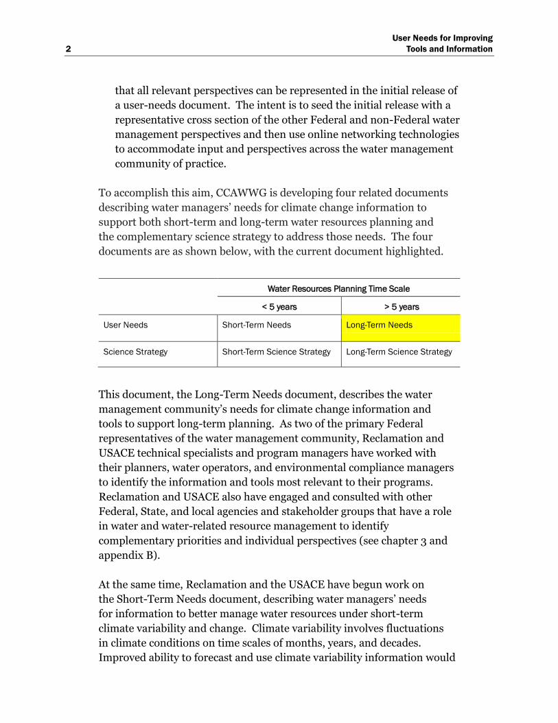
To accomplish this aim, CCAWWG is developing four related documents
describing water managers’ needs for climate change information to
support both short-term and long-term water resources planning and
the complementary science strategy to address those needs. The four
documents are as shown below, with the current document highlighted.
Water Resources Planning Time Scale
< 5 years > 5 years
User Needs Short-Term Needs Long-Term Needs
Science Strategy Short-Term Science Strategy Long-Term Science Strategy
This document, the Long-Term Needs document, describes the water
management community’s needs for climate change information and
tools to support long-term planning. As two of the primary Federal
representatives of the water management community, Reclamation and
USACE technical specialists and program managers have worked with
their planners, water operators, and environmental compliance managers
to identify the information and tools most relevant to their programs.
Reclamation and USACE also have engaged and consulted with other
Federal, State, and local agencies and stakeholder groups that have a role
in water and water-related resource management to identify
complementary priorities and individual perspectives (see chapter 3 and
appendix B).
At the same time, Reclamation and the USACE have begun work on
the Short-Term Needs document, describing water managers’ needs
for information to better manage water resources under short-term
climate variability and change. Climate variability involves fluctuations
in climate conditions on time scales of months, years, and decades.
Improved ability to forecast and use climate variability information would
User Needs for Improving
Tools and Information 3
greatly enhance the ability of water managers and water users to plan their
short-term-operations and water delivery schedules. The influence of
climate change on short-term climate variability is an additional factor
that is now central to this area of concern.
In response to these user-needs documents, the USGS and NOAA will
jointly prepare two documents describing respectively a science strategy
for meeting short-term and long-term needs for information and tools.
Development of those documents also will incorporate perspectives
from other Federal and non-Federal representatives of the scientific
community.
Note: This report refers to planning as the analyses conducted
to inform decisions about water system development and
management. In contrast, USACE defines Planning as a six-step
process in accordance with Economic and Environmental
Principles and Guidelines for Water and Related Resources
Implementation Studies (Water Resources Council 1983) and as
authorized by the Water Resources Development Act of 1986
(Public Law 99-662) (see Orth and Yoe 1997). The Planning
process includes decisionmaking under uncertainty, based on
information from these analyses. Although decisionmaking is not
explicitly addressed in the planning definition of this report,
many gaps in this report address how supporting analyses are
affected by knowledge limits and uncertainties. Research to
address such gaps, thus, should benefit decisionmaking in
Planning processes.
Audience: This document is meant to help focus research and
technology efforts to address information and tools gaps relevant to the
water management user community. As such, the primary audience for
this document is the research and technology community in position to
address these gaps. Such community members include CCAWWG science
agencies (NOAA, USGS), other Federal research entities and programs
(e.g., National Science Foundation, National Aeronautics and Space
Administration, U.S. Environmental Protection Agency, U.S. Department
of Agriculture, U.S. Forest Service, Department of Energy), State and local

User Needs for Improving
4 Tools and Information
science centers, academic institutions, and the members of the
practitioner community that support climate and water resources
research.
Summary of Gap Categories: Technical climate change information
may be incorporated into longer-term water resources planning using
various methods. For this report, eight technical steps representative of
these various methods are used to categorize tools and information needs
(i.e., gaps). These steps are:
1. Summarize Relevant Literature: For a given planning study, this step
involves identifying, synthesizing, and summarizing previous research on
global to regional climate change and what it means for the region’s water
resources.
2. Obtain Climate Change Information: This step involves obtaining
contemporary climate projections and associated uncertainties that may
have been spatially downscaled to finer resolution desired for water
resources planning at the regional to local scale. This step also involves
consideration of paleoclimate proxies that may imply climate conditions
different from those of the observed record.
3. Make Decisions About How To Use the Climate Change Information:
From the body of climate projections surveyed, decisions must be made on
which projections to use and which aspects of these projections to relate to
planning assumptions on water supplies, water demands, and operating
constraints.
4. Assess Natural Systems Response: Based on the preceding step’s
decisions, this step involves assessing the natural systems response under
projected climate conditions. Results from these analyses will be used to
set assumptions about future water supplies, water demands, and
operating constraints. Types of natural systems responses include
watershed hydrology, ecosystems, land cover, water quality, consumptive
use requirements of irrigated lands, sedimentation and river hydraulics,
and sea level rise.
5. Assess Socioeconomic and Institutional Response: This step involves
assessing social, economic, and institutional responses to climate change
that could influence planning assumptions concerning water demands and

User Needs for Improving
Tools and Information 5
operating constraints (e.g., constraints that determine source of supply
preference and/or expected level of operating performance relative to
objectives such as flood risk reduction, environmental management, water
quality management, water allocation for agricultural and municipal use,
energy production, recreation, and navigation).
6. Assess System Risks and Evaluate Alternatives: This step involves
assessing system risks based on future planning assumptions (informed by
Steps 4 and 5); and, as necessary, evaluating long-term management
alternatives to address climate change risks. For example, many water
resources management studies focus on operations risk and assumptions
about future water supplies, demands, and operating constraints. In
contrast, infrastructure safety or flood risk reduction studies focus on
human safety and economic and environmental damages under
assumptions about future extreme hydrologic event probabilities; and
water quality studies focus on the interaction between the human
activities, landscape hydrology, and aquatic systems.
7. Assess and Characterize Uncertainties: This step involves assessing and
characterizing uncertainties accumulated during preceding steps (e.g.,
uncertainties of projecting future factors forcing climate, simulating
climate, downscaling climate, assessing natural and social system
responses, etc.).
8. Communicating Results and Uncertainties to Decisionmakers: This step
involves aggregating information from previous steps and then
communicating this distilled information to decisionmakers to support
planning decisions.
Table ES-1 provides an initial list of gaps in tools and information
associated with these steps. Given the geographic areas served by
Reclamation and USACE, these gaps may be thought of as being nationally
relevant. While this document presents gaps that are particularly relevant
for management of Reclamation and USACE water supply and river
regulation systems, it was envisioned that these gaps may be generally
applicable for long-term management of any type of water infrastructure.
To gauge this possibility, feedback on the gaps in table ES-1 was gathered
from non-Federal organizations and other Federal agencies. The most-
frequent relative priority (i.e., low, medium, high) assigned by
Reclamation and USACE for each gap is shown next to the most frequent

User Needs for Improving
6 Tools and Information
relative priority received from all Federal (including Reclamation and
USACE) and non-Federal respondents combined. In the event of a tie, the
lower priority was assigned. For example, if one gap had an equal number
of medium priority responses as high responses, then the gap was assigned
a medium priority. An examination of table ES-1 shows the priority
rankings assigned by Reclamation/USACE compare favorably with those
assigned by all respondents combined with only minor differences (e.g.,
low versus medium or medium versus high) on 12 of the 39 gaps listed.
Table ES-1. Summary of gaps and relation to other needs assessments
Technical Planning Steps and Associated Gaps
in Tools and Information
Priority Ranking1 Other Assessments
Having Related
Discussion
Reclamation/
USACE
All
Respondents
Step 1 – Summarize Relevant Literature
1.01 Access to a clearinghouse of climate
change literature relevant to water
management or access to a bibliography of
recommended literature to represent in
literature syntheses.
Low Low CCAWWG 2008
1.02 Region-specific literature summaries,
regularly maintained and peer-reviewed.
Medium Medium CCAWWG 2008
Step 2 – Obtaining Climate Change Information
2.01 Improved skill in simulating long-term
global to regional climate.
High High Reclamation 2007,
Western States Water
Council (WSWC) 2007
2.02 Downscaled data at finer space and
time resolutions and for different variables.
High High CCAWWG 2008, WSWC
2007
2.03 Information on the strengths and
weaknesses of downscaled data and the
downscaling methodologies used to
develop these data (including both statistical
and dynamical methods and associated
approaches for climate model bias-
correction).
High High WSWC 2007
2.04 Indication of conditions of where and
when the stationarity assumption of
statistical downscaling may not hold
(defined above) and should motivate use of
dynamical downscaling techniques rather
than statistical.
Medium Medium CCAWWG 2008, WSWC
2007
1 Color shading indicates priority rating on research to address gaps: low (yellow), medium (light orange), and
high (dark orange).

User Needs for Improving
Tools and Information 7
Table ES-1. Summary of gaps and relation to other needs assessments (continued)
Technical Planning Steps and Associated
Gaps in Tools and Information
Priority Ranking1 Other Assessments
Having Related
Discussion
Reclamation/
USACE
All
Respondents
Step 2 – Obtaining Climate Change Information (continued)
2.05 Synthesis of sea level projection
information and guidance on consistent use
in planning for all Reclamation and
USACE coastal areas.
Low Low
Step 3 – Make Decisions About How To Use the Climate Change Information
3.01 Understanding on observed climate
variability from daily to multidecadal time
scales, which underpins interpretation of
future variability in climate projections and
its relation to planning assumptions.
High High Reclamation 2007,
WSWC 2007
3.02 Understanding how to interpret future
variability in climate projections and
relevance to operating constraints on
shorter- to longer-term time scales (from
daily to multidecadal).
High High Reclamation 2007
3.03 Basis for culling or weighting climate
projections (if at all) when deciding which
projections to use in planning.
Medium Medium CCAWWG 2008
3.04 Guidance on how to appropriately relate
planning assumptions to either Period-
Change or Time-Developing aspects of
climate projections when deciding how to
use projections in planning.
Low Medium
3.05 Guidance on how to jointly utilize the
longer-term climate variability from observed
records, paleoclimate, and projected climate
information when portraying drought and
surplus possibilities in planning.
Medium High Reclamation 2007,
CCAWWG 2008
3.06 Method and basis for estimating
extreme meteorological event possibilities,
deterministically or probabilistically, in a
changing climate.
High High CCAWWG 2008
1 Color shading indicates priority rating on research to address gaps: low (yellow), medium (light orange), and
high (dark orange).

User Needs for Improving
8 Tools and Information
Table ES-1. Summary of gaps and relation to other needs assessments (continued)
Technical Planning Steps and Associated
Gaps in Tools and Information
Priority Ranking1 Other Assessments
Having Related
Discussion
Reclamation/
USACE
All
Respondents
Step 4 – Assess Natural Systems Response – Watershed Hydrology (WH), Ecosystems (E), Land
Cover (LC), Water Quality (WQ), Consumptive Use on Irrigated Lands (CU), and Sedimentation and
River Hydraulics (SRH)
4.01 (WH) Guidance on strengths and
weaknesses of watershed hydrologic
models/methods to support scoping
decisions in planning.
Low Low CCAWWG 2008
4.02 (WH) Understanding how climate
change should impact potential
evapotranspiration and how it is represented
in watershed hydrologic models.
High High Reclamation 2007
4.03 (WH) Method and basis for estimating
extreme hydrologic event possibilities,
deterministically or probabilistically, in a
changing climate. (Similar to Gap 3.06 but
focused here on hydrology rather than
meteorological variables)
High High CCAWWG 2008
4.04 (WH) Guidance on strengths and
weaknesses of available versions of
spatially distributed hydrologic weather
data that may be used for both watershed
hydrologic model development (Step 4) and
in climate model bias-correction (Step 2).
Medium Medium
4.05 (WH) Understanding how climate
change should impact groundwater recharge
and groundwater interaction with surface
water supplies.
Medium Medium Reclamation 2007,
CCAWWG 2008
4.06 (E) Understanding how climate change
should impact inland and coastal
anadromous fisheries.
Medium Low CCAWWG 2008
4.07 (E) Understanding how climate change
may impact riparian ecosystems and
vegetation that affect both longer-term water
budgets and ecological resources.
High Medium CCAWWG 2008
4.08 (E) Understanding translated into
model frameworks for assessing climate
change responses for fisheries, nonnative
riparian vegetation, and other species or
habitat conditions.
High Medium CCAWWG 2008
1 Color shading indicates priority rating on research to address gaps: low (yellow), medium (light orange), and
high (dark orange).

User Needs for Improving
Tools and Information 9
Table ES-1. Summary of gaps and relation to other needs assessments (continued)
Technical Planning Steps and Associated Gaps
in Tools and Information
Priority Ranking1
Other Assessments
Having Related
Discussion
Reclamation/
USACE
All
Respondents
Step 4 – Assess Natural Systems Response – Watershed Hydrology (WH), Ecosystems (E), Land
Cover (LC), Water Quality (WQ), Consumptive Use on Irrigated Lands (CU), and Sedimentation and
River Hydraulics (SRH) (continued)
4.09 (LC) Understanding how climate and/or
carbon dioxide changes should impact land
cover communities that control natural
evapotranspiration and soil erosion potential.
Medium Low Reclamation 2007,
CCAWWG 2008
4.10 (WQ) Understanding how water quality
characteristics depend on climatic variables
and how dependencies may evolve in a
changing climate.
High High
4.11 (CU) Understanding how climate and
carbon dioxide changes should impact plant
physiology, how impacts vary with crop type,
and how impacts affect irrigation demand.
Medium Medium CCAWWG 2008
4.12 (SRH) Understanding how climate
and/or land cover changes will change
watershed sediment yield, changes in
sediment constituency, and the resulting
impacts on water resources.
Medium Medium
4.13 (SRH) Understanding how climate,
land cover, and/or sedimentation changes
will affect river and reservoir ice-event
potential.
Medium Low
Step 5 – Assess Socioeconomic and Institutional Response
5.01 Understanding how socioeconomic
factors may affect flood risk reduction and
reservoir regulation objectives in a changing
climate (e.g., flood protection values, land
management).
Medium High CCAWWG 2008
5.02 Understanding how socioeconomic
factors may affect water and power delivery
reliability, water allocations, as well as
decisions on source of supply under a
changing climate (e.g., groundwater
pumping versus surface water diversion).
High High CCAWWG 2008
1 Color shading indicates priority rating on research to address gaps: low (yellow), medium (light orange), and
high (dark orange).

User Needs for Improving
10 Tools and Information
Table ES-1. Summary of gaps and relation to other needs assessments (continued)
Technical Planning Steps and Associated Gaps
in Tools and Information
Priority Ranking1
Other Assessments
Having Related
Discussion
Reclamation/
USACE
All
Respondents
Step 5 – Assess Socioeconomic and Institutional Response (continued)
5.03 Understanding how institutional
realities currently control socioeconomic
responses to climate variability and could
control socioeconomic responses under a
changing climate.
Medium Low
Step 6 – Assess System Risks and Evaluate Alternatives
6.01 Guidance on how to conduct an
adaptation evaluation that efficiently
explores and ranks strategy options,
potentially using optimization techniques.
High High CCAWWG 2008
6.02 Guidance on how to portray realistic
operator “learning” in evaluations supporting
planning for climate change adaptation.
Low Low CCAWWG 2008
6.03 Guidance on how to assess the effect
of planning proposals on climate.
Low Medium CCAWWG 2008
Step 7 – Assess and Characterize Uncertainties
7.01 Uncertainty information on global
climate projections data, including
uncertainties about climate system science,
portrayal in climate models, emissions
scenario development, and simulation
methods.
High High CCAWWG 2008
7.02 Uncertainty information on regional
climate projections data, including
uncertainties from choice of bias-correction
and spatial downscaling methods.
High High CCAWWG 2008
7.03 Uncertainty in planning results
stemming from method choices on how to
use transient characteristics of climate
projections in planning scenarios.
Medium Medium CCAWWG 2008
7.04 For each response analysis on a natural
system, uncertainty information on system
science and associated ways of portraying
this science in a system model and the
observations used to customize a model for a
specific system.
Medium High CCAWWG 2008
1 Color shading indicates priority rating on research to address gaps: low (yellow), medium (light orange), and
high (dark orange).

User Needs for Improving
Tools and Information 11
Table ES-1. Summary of gaps and relation to other needs assessments (continued)
Technical Planning Steps and Associated Gaps
in Tools and Information
Priority Ranking1
Other Assessments
Having Related
Discussion
Reclamation/
USACE
All
Respondents
Step 7 – Assess and Characterize Uncertainties (continued)
7.05 For each response analysis on a socio-
economic system, uncertainty information on
system science and associated ways of
portraying this science in a system model and
the observations used to customize a model
for a specific system.
High Medium CCAWWG 2008
Step 8 – Communicating Results and Uncertainties to Decisionmakers
8.01 Guidance on strengths and weaknesses
of various methods for communicating
results and uncertainties affected by using
climate projection information.
High High CCAWWG 2008
8.02 Guidance on how to make decisions
given the uncertainties introduced by
considering climate projection information.
High High
1 Color shading indicates priority rating on research to address gaps: low (yellow), medium (light orange), and
high (dark orange).
Gaps are more fully discussed in section 2.4, and the priority ratings
received during the perspective gathering process is discussed in
section 3.0 (e.g., inviting prioritization of research to address gaps,
inviting general comments, and inviting suggestions on missing gaps). A
complete record of perspectives received, including relative priority
assignments, are included in appendices B–D.
The relative priority ratings assigned to each of the gaps listed in table ES-1
were also averaged across the gaps associated with each Technical Step
(also known as Gap Category) to derive a relative priority that could be
associated for each Technical Step. These results are shown in table ES-2.

User Needs for Improving
12 Tools and Information
Table ES-2. Prioritization of research to support each gap category
Technical
Step
Gap Category
(Technical Step)
Average Priority Rankings1
USACE/
Reclamation
All Respondents
Combined
1 Summarize Relevant Literature 1.5 1.5
2 Obtaining Climate Change Information 2.5 2.4
3 Make Decisions About How To Use the
Climate Change Information
3.0 2.7
4 Assess Natural Systems Response 3.0 1.9
5 Assess Socioeconomic and Institutional
Response
2.5 2.3
6 Assess System Risks and Evaluate
Alternatives
1.5 2.0
7 Assess and Characterize Uncertainties 2.0 2.6
8 Communicating Results and
Uncertainties to Decisionmakers
3.0 3.0
1 Low = 1, Medium = 2, High = 3.
In terms of summary messages heard, Reclamation and the USACE
indicate relatively greater concern for the following three Technical Steps:
Step 3: Make Decisions About How to Use the Climate Change
Information
Step 4: Assess Natural System Responses
Step 8: Communicating Results and Uncertainties to Decisionmakers
This compares favorably to the perspectives of water managers from all
respondents combined with agreement that both Steps 3 and Step 8
deserve the greatest concern. However, all respondents combined indicate
a greater concern for Step 7: Assess and Characterize Uncertainties.
The remaining steps received relatively lower priority. Review of gap-
specific summaries (section 3.3) suggests that much of this lower
prioritization stems from perception that a relatively greater
understanding currently exists in these step areas compared to those that

User Needs for Improving
Tools and Information 13
were given higher priority and does not necessarily indicate they are not as
important as those assigned a high priority.
Lastly, a number of commenting entities provided letter responses, some
of which highlighted themes that were largely absent in the draft version of
this report. Those letter responses are provided in appendix D. Two
notable themes were:
Monitoring and Data Collection: Need for supporting current
data collection networks and understanding their adequacy to support
water management in a changing climate.
Making Decisions Under Uncertainty: Need for understanding
the relative merits of various tools/concepts (e.g., adaptive
management, robustness, resilience, flexibility) to support water
management and development under a changing climate, and also
understanding the compatibility of these tools/concepts with current
influences on management (e.g., legislation, appropriations, policy).

User Needs for Improving
Tools and Information 15
Acknowledgements
Executive Sponsors
Bureau of Reclamation
Michael Gabaldon – Director, Technical Resources Karl Wirkus – Regional Director, Pacific Northwest Region (formerly Deputy Commissioner of Operations)
U.S Army Corps of Engineers
Steven Stockton – Director of Civil Works Robert Pietrowsky – Director of Institute for Water Resources James C. Dalton – Chief, Engineering and Construction Theodore A. Brown – Chief, Planning and Policy
Reclamation Reviews Provided by:
Great Plains Region – Eastern Colorado Area Office Lower Colorado Region – Regional Office Mid-Pacific Region – Central California Area Office Mid-Pacific Region – Regional Office Pacific Northwest Region – Regional Office
USACE Reviews Provided by:
Great Lakes and Ohio River Division South Atlantic Division South Atlantic Division–Jacksonville District Northwestern Division–Portland District Northwestern Division–Walla Walla District
Review, Advice, and Contributions by:
Karen Metchis – Environmental Protection Agency – Office of Water Nancy Steinberger – Federal Emergency Management Agency Earl Greene – Unites States Geological Survey – Water Resources Discipline Robert Webb – National Oceanic and Atmospheric Administration – Earth System Research Laboratory Michael Alexander – National Oceanic and Atmospheric Administration – Earth System Research Laboratory Andrea Ray – National Oceanic and Atmospheric Administration – Earth System Research Laboratory

User Needs for Improving
16 Tools and Information
Joseph Barsugli – National Oceanic and Atmospheric Administration – University of Colorado Cooperative Institute for Research in Environmental Science
Edited by:
David Cate – USACE – Remote Sensing/GIS Center of Expertise Patty Alexander – Reclamation – Technical Service Center
Independent Perspectives Were Contributed and Published in This
Report by Representatives From the Following Organizations:
Non-Federal organizations:
American Society of Civil Engineers American Water Works Association Association of Metropolitan Water Agencies California Department of Water Resources California Water and Environmental Modeling Forum Family Farm Alliance Seattle City Light Water Utility Climate Alliance Western States Water Council
Other Federal water and water-related management organizations:
Federal Emergency Management Agency Federal Energy Regulatory Commission NOAA National Ocean Service - Coastal Services Center Power Marketing Administration – Western Area Power Administration USEPA – Office of Research and Development USEPA – Office of Water USEPA – Region 8
The full report can be downloaded from the Reclamation Web site at:
www.usbr.gov/climate/userneeds.