![BOTANICAL PREPARATIONS QUESTIONNAIRE - EHPM Questionnaire Botanical... · 1 BOTANICAL PREPARATIONS QUESTIONNAIRE IDENTIFICATION - Manufacturer: [ ….. ] - Distributor/Sales representative:](https://static.fdocuments.in/doc/165x107/5b087ba37f8b9ac90f8c9b6d/botanical-preparations-questionnaire-questionnaire-botanical1-botanical-preparations.jpg)
Addendum to Report WB653: Yeelirrie Project Flora and ... · Addendum to Report WB653 June 2015 i...
164
Addendum to Report WB653: Yeelirrie Project Flora and Vegetation Survey (February 2011) June 2015 Cameco Australia Report Ref: WB839
Transcript of Addendum to Report WB653: Yeelirrie Project Flora and ... · Addendum to Report WB653 June 2015 i...

Addendum to Report WB653: Yeelirrie Project Flora and Vegetation Survey (February 2011)
June 2015
Cameco Australia Report Ref: WB839

Addendum to Report WB653 June 2015
© Landcare Holdings Pty Ltd trading as Western Botanical Unit 33, 6 Keane St, Midland WA 6056 PO Box 3608, Midland WA 6056 T (08) 9274 0303F (08) 9274 0136
Report No: WB839
Client Name: Cameco Australia Pty Ltd
Client Address: 24 Hasler Road, Osborne Park 6017
Version Prepared By Approved for Issue Issue Date
Version 1 D. Leach & G. Cockerton
02/04/2015 02/04/2015
Version 2 D. Leach 21/05/2015 21/05/2015
Version 3 D. Leach 24/06/2015 24/06/2015
Version 4 D. Leach 26/06/2015 26/06/2015
Version 5 D. Leach 29/06/2015 2 /06/2015
This document has been prepared to the requirements of the client identified on this page and no representation is made to any third party. It may be cited for the purposes of scientific research or other fair use, but it may not be reproduced or distributed to any third party by any physical or electronic means without the express permission of the client for whom it was prepared or Western Botanical.
This report has been designed for double-sided printing

Addendum to Report WB653 June 2015
i
Contents
Executive Summary viii
1. Introduction 1
2. Previous Botanical Surveys 4
3. Review of Flora Survey Methods 63.1. Field Survey 6
3.1.1. Timing of Field Surveys 63.1.2. Quadrat Sizes 73.1.3. Sufficiency of Field Sites (Quadrats and Releves) 8
3.2. Data Analysis 103.3. Conformity to Guidelines and Requirements 11
3.3.1. Planning and design of flora and vegetation surveys 113.3.2. Presentation and reporting 13
4. Update of Flora 174.1. Taxonomic Name Changes 224.2. Additional Species 244.3. Identification and Entry Corrections 244.4. Conservation Status 264.5. Naturalised Status (Weeds) 264.6. Range Extensions 27
5. Significant Flora 325.1. Threatened Flora 32
5.1.1. Atriplex sp. Yeelirrie Station (L. Trotter & A. Douglas LCH 25025) 32
5.2. Priority Flora 385.2.1. Baeckea sp. Sandstone (C.A. Gardner s.n. 26 Oct 1963)
Priority 3 385.2.2. Bossiaea eremaea (Priority 3) 415.2.3. Calytrix uncinata (Priority 3) 455.2.4. Comesperma viscidulum (Priority Four) 485.2.5. Eremophila arachnoides subsp. arachnoides (Priority 3) 525.2.6. Euryomyrtus inflata (Priority 3) 565.2.7. Neurachne lanigera (Priority 1) 605.2.8. Olearia arida (Priority 4) 64

Addendum to Report WB653 June 2015
ii
5.2.9. Rhagodia sp. Yeelirrie Station (K.A. Shepherd et al. KS1396) (Priority 1) 68
5.2.10. Sauropus ramosissimus (Priority 3) 725.2.11. Sida picklesiana (Priority 3) 765.2.12. Thryptomene sp. Leinster (B.J. Lepschi & L.A. Craven 4362)
(Priority 3) 795.3. Flora of Interest 83
5.3.1. Acacia sp. (G. Cockerton & R. Graham LCH 25491) 865.3.2. Acacia sp. resprouter (G. Cockerton & R. Graham
LCH 25490) 865.3.3. Acacia sp. Yakabindie (G. Cockerton & G. O’Kefe
LCH 14274) aff. kempeana 875.3.4. Chondropyxis halophila 885.3.5. Eragrostis tenellula 895.3.6. Euphorbia biconvexa 905.3.7. Hibbertia sp. aff. exasperata (D. Brassington & S. Colwill
LCH 29097) 915.3.8. Mollugo cerviana 925.3.9. Olearia sp. Sherwood Breakaways (A. Taylor LCH 25552) 935.3.10. Prostanthera sp. Bullimore Sandplain (G. Cockerton & D.
True 12813) 955.3.11. Scaevola spinescens terete leaf form (G. Cockerton & C.
Ringrose LCH 14560) 965.3.12. Sporobolus australasicus 995.3.13. Tribulus sp. LCH 27811 1005.3.14. Vittadinia dissecta var. hirta 101
6. DPaW Database Searches 1036.1. Threatened and Priority Flora 1036.2. Threatened and Priority Ecological Communities 103
7. Review of Vegetation and Mapping 1057.1. Vegetation Condition Mapping 1057.2. Changes Due to Update of Flora 1087.3. Potential Changes Due to Improved Analysis 1097.4. Clarifications to Mapping, Vegetation Unit Descriptions, and Sites 109
8. Conclusion & Recommendations 111
9. Reference List 113
10. List of Participants 117

Addendum to Report WB653 June 2015
iii
Appendices Appendix 1. List of specimens vouchered with Western Australian Herbarium for WB653. 118Appendix 2. Revised local species list (Study Areas 1, 2, & 3). 124Appendix 3. Revised regional species list (Study Areas 4 - 16). 138Appendix 4. Summary of DPaW Threatened and Priority Flora Database Search 142Appendix 5. Keighery Vegetation Condition Scale 148Appendix 6. Corrected quadrat and releve summaries of WB653. 150
Tables Table 1. Summary of previous botanical surveys relevant to the Yeelirrie Project and the surrounding region (chronological order). 4Table 2. Summary of quadrats and releves per vegetation unit performed during surveys of WB653, sorted by total number of quadrats. 9Table 3. Taxonomic name changes for species lists since WB653 23Table 4. Additional species to the Local Species List since WB653. 24Table 5. Identification and data entry corrections since WB653. 25Table 6. Changes to conservation status of species since WB653. 26Table 7. National and Western Australian weeds lists checked and relevant results. 27Table 8. Revision of WB653 species lists range extensions. *AVH (Australian Virtual Herbarium 2014). 29Table 9. Summary of species no longer considered Species of Interest (since WB653). 32Table 10. Locations of Rhagodia sp. Yeelirrie Station populations (datum GDA94). 69Table 11. Additional Priority species records returned by DPaW Threatened and Priority flora database search since WB653. 103Table 12. Summary of species name changes within WB653 vegetation unit descriptions. 108Table 13. Summary of potential changes to vegetation maps due to improved analysis. 109Table 14. Specimens lodged to Western Australian Herbarium following (but as part of) the publication WB653. Taxa names and conservation status used for the original specimen lodgement are retained to enable cross-reference of records. 119Table 15. Specimens lodged to Western Australian Herbarium as part of this Addendum Report. 123Table 16. Summary of Threatened and Priority flora identified by DPaW searches. 143Table 17. Coordinates of known Threatened and Priority flora populations (DPaW search results only). 145

Addendum to Report WB653 June 2015
iv
Figures Figure 1. Site location of the proposed Yeelirrie Project. 2Figure 2. Rainfall during the survey period of WB653 compared to historic mean, and the timing of field survey visits. 7Figure 3. Location of local study areas (1 to 3) encompassing species presented on the ‘local species list’. 18Figure 4. Location of regional study areas (4 to 16) encompassing species presented on the ‘regional species list’. 20Figure 5. Distribution map of Atriplex sp. Yeelirrie Station, (L. Trotter & A. Douglas LCH 25025) within Western Australia (Western Australian Herbarium 1998-). 34Figure 6. Locations of Atriplex sp. Yeelirrie Station (L. Trotter & A. Douglas LCH 25025) populations at Yeelirrie Station. 35Figure 7. Distribution map of Baeckea sp. Sandstone (C.A. Gardner s.n. 26 Oct 1963) within Western Australia (Western Australian Herbarium 1998-). 38Figure 8. Records of Baeckea sp. Sandstone (C.A. Gardner s.n. 26 Oct 1963), Priority 3, within and near local Study Areas (1, 2, and 3) at Yeelirrie. 39Figure 9. Distribution map of Bossiaea eremaea within Western Australia (Western Australian Herbarium 1998-). 42Figure 10. Records of Bossiaea eremaea, Priority 3, within and near local Study Areas (1, 2, and 3) at Yeelirrie. 43Figure 11. Distribution map of Calytrix uncinata within Western Australia (Western Australian Herbarium 1998-). 45Figure 12. Records of Calytrix uncinata, Priority 3, within and near local Study Areas (1, 2, and 3) at Yeelirrie. 46Figure 13. Distribution map of Comesperma viscidulum within Western Australia (Western Australia). 49Figure 14. Records of Comesperma viscidulum, Priority 4, within and near local Study Areas (1, 2, and 3) at Yeelirrie. 50Figure 15. Distribution map of Eremophila arachnoides subsp. arachnoides (left) and Eremophila pantonii (right) within Western Australia (Western Australian Herbarium 1998-). 53Figure 16. Records of Eremophila arachnoides subsp. arachnoides, Priority 3, within and near local Study Areas (1, 2, and 3) at Yeelirrie. 54Figure 17. Distribution map of Euryomyrtus inflata within Western Australia (Western Australian Herbarium 1998-). 57Figure 18. Records of Euryomyrtus inflata, Priority 3, within and near local Study Areas (1, 2, and 3) at Yeelirrie. 58Figure 19. Distribution map of Neurachne lanigera within Western Australia (Western Australian Herbarium 1998-). 61Figure 20. Records of Neurachne lanigera, Priority 1, within and near local Study Areas (1, 2, and 3) at Yeelirrie. 62Figure 21. Distribution of Olearia arida within Western Australia (Western Australian Herbarium 1998-). 65

Addendum to Report WB653 June 2015
v
Figure 22. Records of Olearia arida, Priority 4, within and near local Study Areas (1, 2, and 3) at Yeelirrie. 66Figure 23. Distribution map of Rhagodia sp. Yeelirrie Station (K.A. Shepherd et al. KS1396) inWestern Australia (Western Australian Herbarium 1998-). 69Figure 24. Records of Rhagodia sp. Yeelirrie Station (K.A. Shepherd et al. KS1396), Priority 1, within and near local Study Areas (1, 2, and 3) at Yeelirrie. 70Figure 25. Distribution map of Sauropus ramosissimus in Western Australia (Council of Heads of Australasian Herbaria 2014). 73Figure 26. Records of Sauropus ramosissimus, Priority 3, within and near local Study Areas (1, 2, and 3) at Yeelirrie. 74Figure 27. Distribution map of Sida picklesiana within Western Australia (Western Australian Herbarium 1998-). 76Figure 28. Records of Sida picklesiana, Priority 3, within and near local Study Areas (1, 2, and 3) at Yeelirrie. 77Figure 29. Distribution map of Thryptomene sp. Leinster (B.J. Lepschi & L.A. Craven 4362) within Western Australia (Western Australian Herbarium 1998-). 80Figure 30. Records of Thryptomene sp. Leinster (B.J. Lepschi & L.A. Craven 4362), Priority 3, within and near local Study Areas (1, 2, and 3) at Yeelirrie. 81Figure 31. Recorded locations of Flora of Interest in and around Study Areas 1, 2, and 3. 84Figure 32. Distribution map of Chondropyxis halophila within Western Australia (Western Australian Herbarium 1998-). 88Figure 33. Distribution of Eragrostis tenellula within Western Australia (Western Australian Herbarium 1998-). 90Figure 34. Distribution map of Euphorbia biconvexa within Western Australia (Western Australian Herbarium 1998-). 91Figure 35. Distribution map of Hibbertia exasperata within Western Australia (Western Australian Herbarium 1998-). 92Figure 36. Distribution map of Mollugo cerviana within Western Australia (Western Australian Herbarium 1998-). 93Figure 37. Distribution map of Prostanthera althoferi subsp. althoferi within Western Australia (modified from Western Australian Herbarium 1998-). 96Figure 38. Distribution map of Scaevola spinescens (sens. lat.) within Western Australia (Western Australian Herbarium 1998-). 98Figure 39. Western Botanical records and select Western Australian Herbarium records of Scaevola spinescens terete leaf form (G. Cockerton & C. Ringrose LCH 14560) in the north-eastern Goldfields. 99Figure 40. Distribution of Sporobolus austrolasicus within Western Australia (Western Australian Herbarium 1998-). 100Figure 41. Distribution maps of Vittadinia dissecta var. hirta (Western Australian Herbarium 1998- (left), Council of Heads of Australasian Herbaria 2014 (right). 102

Addendum to Report WB653 June 2015
vi
Figure 42. Vegetation condition map for the Yeelirrie Project, current as of the publication of WB653 (February 2011). 106
Plates Plate 1. Photos of Atriplex sp. Yeelirrie Station (L. Trotter & A. Douglas LCH 25025) showing growth habit and divaricate branching structure. 33Plate 2. Photos of Atriplex sp. Yeelirrie (L. Trotter & A. Douglas LCH 25025) showing female flowers (top left), male flowers (top right), and two morphotypes of fruiting bracteoles; no appendages (bottom left), and with appendages (bottom right) (photos by Dr Kelly). 34Plate 3. Photos of Bossiaea eremaea showing growth habit (left) and branch and flower arrangement (right). 41Plate 4. Photos of Calytrix uncinata showing growth habit and white flowers. 45Plate 5. Photos of Comesperma viscidulum showing growth habit and leaf features (Australian Herbarium 1998-). 48Plate 6. Photos of Eremophila arachnoides subsp. arachnoides showing growth habit and flowers. 53Plate 7. Photos of Euryomyrtus inflata showing growth habit (lower left of first photo) and brach and leaf arrangement. 57Plate 8. Photos of Neurachne lanigera showing plant habit, woolly base, conspicuous leaf hairs, and inflorescence. 60Plate 9. Photo of Olearia arida showing leaf structure and flower. 64Plate 10. Photos of Rhagodia sp. Yeelirrie Station (K.A. Shepherd et al. KS1396) showing growth habit (left) and both male and female flowers occurring on the same plant (right). 68Plate 11. Photos of Sauropus ramosissimus showing growth habit and branch and stem habit. 72Plate 12. Photos of Sida picklesiana showing growth habit, leaves and flower. 76Plate 13. Photos of Thryptomene sp. Leinster (BJ. Lepschi & L.A. Craven 4362) showing growth habit, leaf arrangement, and flowers. 79Plate 14. Photo of Acacia sp. (G. Cockerton & R. Graham LCH 25491) showing growth habit. 86Plate 15. Photos of Acacia sp. resprouter (G. Cockerton & R. Graham LCH 25490) showing habit within SAWS vegetation unit (left) and leaf arrangement (right). 87Plate 16. Photos of Acacia sp. Yakabindie (G. Cockerton & G. O’Keefe LCH 14274) aff. kempeana showing growth habit and leaves. 88Plate 17. Photo of Eragrostis tenellula (Simon & Alfonso 2014, photo by E. Anderson) showing typical growth habit. 89Plate 18. Photo of Euphorbia biconvexa and showing leaf and fruit arrangement (Western Australian Herbarium 1998-). 90Plate 19. Photos of Hibbertia sp. aff. exasperata (D. Brassington & S. Colwill LCH 29097) showing growth habit and leaf arrangement. 92

Addendum to Report WB653 June 2015
vii
Plate 20. Photos of Olearia sp. Sherwood Breakaways (A. Taylor LCH 25552) showing growth habit, leaf detail, and flowers. 94Plate 21. Photos of Prostanthera sp. Bullimore Sandplain (G. Cockerton & D. True LCH 12813) showing growth habit and leaf arrangement. 96Plate 22. Photos of Scaevola spinescens terete leaf form (G. Cockerton & C. Ringrose LCH 14560) showing growth habit and branch, leaf, and flower arrangement. 98Plate 23. Photo of Sporobolus australasicus (Simon & Alfonso 2014, photo by D. Albrecht) showing its growth habit. 100Plate 24. Photo of Vittadinia dissecta var. hirta (Council of Heads of Australasian Herbaria 2014, photo Don Wood). 101

Addendum to Report WB653 June 2015
viii
In preparation for a Public Environmental Review (PER) level of assessment of the Yeelirrie Uranium Project, Cameco is undertaking a review of relevant previous reports. Western Botanical was commissioned to prepare this Addendum Report (WB839), reviewing and updating results of the Level 2 flora assessment Baseline flora and vegetation survey of the Yeelirrie Project (WB653). Specifically, this addendum report provides (as per Cameco’s scope):
• Overview of previous botanical and flora surveys. • Review of flora survey methods to ensure the meeting of current guidelines and
requirements. • Review and update the flora of the Project Area, including:
– Flora species lists. – Conservation rankings. – Known and additional Flora of Interest. – Existence of TECs (Threatened Ecological Communities) and PECs (Priority
Ecological Communities). • Review of vegetation units and mapping (resulting from flora review). • Recommendations produced from the review of WB653.
Review of flora resulted in updated species names and species lists, in addition to some revised identification determinations and range extension statuses. Conservation rankings of 5 species changed since WB653; Atriplex sp. Yeelirrie Station (L. Trotter & A. Douglass 25025) has been upgraded from Priority 1 to Threatened, Sida sp. Mt Keith (now known as Sida picklesiana) listed as Priority 3, Thryptomene sp. Leinster (B.J. Lepschi & L.A. Craven 4362) downgraded from Priority 1 to Priority 3, and Calytrix erosipetala status of Priority 3 removed, and the status of Alyxia tetanifolia presented in WB653 revised to Priority 3. Likewise, non-priority flora of interest within WB653 have also been revised and re-presented with current information, for completeness.
Desktop DPaW database searches were re-performed to ensure current knowledge of threatened and priority flora, and of threatened and priority ecological communities (TECs and PECs, respectively). No new flora-related TECs or PECs were detected within the Yeelirrie Project area.
Report WB653 paired with this Addendum Report provide sufficient rigor to describe the current vegetation and flora, and facilitate subsequent EPA assessment and auditing.

Addendum to Report WB653 June 2015
1
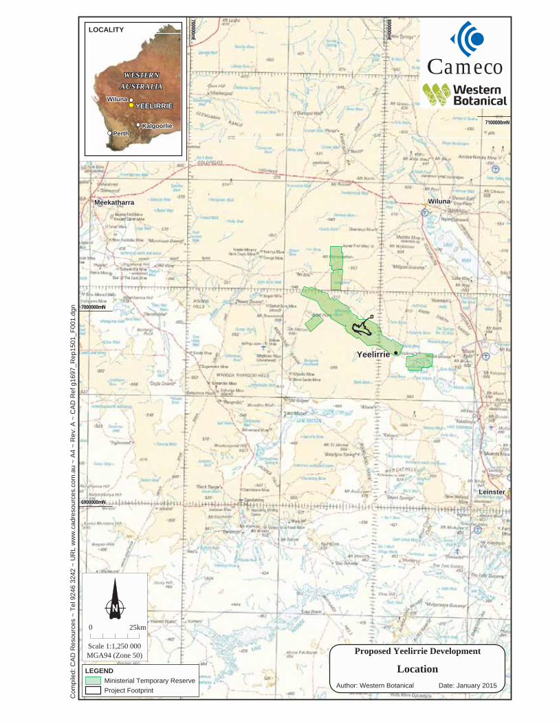
In 2008 BHP Billiton activated plans to develop a uranium mine on Yeelirrie Pastoral Station, 700 km northeast of Perth and 70 km southwest of Wiluna (Figure 1). In 2010 BHP Billiton Yeelirrie Development Company Pty Ltd, through URS Australia Pty Ltd, commissioned Western Botanical to undertake a flora and vegetation assessment of the proposed Project Area. The outcome of the survey was the Yeelirrie Project Flora and Vegetation Survey Baseline Report, February 2011 (WB653) (Western Botanical 2011).
In 2012 Cameco Australia Pty Ltd (Cameco) acquired Yeelirrie from BHP Billiton (BHPB). Cameco is undertaking a review of relevant previous reports in preparation for a Public Environmental Review (PER) level of assessment of the Yeelirrie Uranium Project (the Project). Western Botanical was commissioned to prepare this Addendum Report (WB839) reviewing and updating results of the original WB653 report. Specifically, this addendum report provides (as per Cameco’s scope):
• Overview of previous botanical and flora surveys. • Review of flora survey methods to ensure the meeting of current guidelines and
requirements. • Review and update the flora of the Local Study Area, including:
– Flora species lists. – Conservation rankings. – Known and additional Flora of Interest. – Existence of TECs (Threatened Ecological Communities) and PECs (Priority
Ecological Communities). • Review of vegetation units and mapping (resulting from flora review). • Recommendations produced from the review of WB653.
Addendum to Report WB653 June 2015
2
Figure 1. Site location of the proposed Yeelirrie Project.
LOCALITY
LeinsterLeinster
WilunaWilunaMeekatharraMeekatharra
Com
pile
d: C
AD
Res
ourc
es ~
Tel
924
6 32
42 ~
UR
L w
ww
.cad
reso
urce
s.co
m.a
u ~
A4
~ R
ev: A
~ C
AD
Ref
g16
97_R
ep15
01_F
001.
dgn
0 25km
Scale 1:1,250 000MGA94 (Zone 50)
WESTERNWESTERN
AUSTRALIAAUSTRALIA
KalgoorlieKalgoorliePerthPerth
WilunaWiluna
700000mE
700000mE
800000mE
800000mE
7100000mN7100000mN
6900000mN6900000mN
7000007000000mN
Proposed Yeelirrie Development
LEGEND
Date: January 2015
LocationMinisterial Temporary ReserveProject Footprint
YEELIRRIEYEELIRRIE
amecoC
Author: Western Botanical
YeelirrieYeelirrie

Addendum to Report WB653 June 2015
4
The summary of previous botanical surveys relevant to the Project presented in Western Botanical 2011 (WB653) remains valid up to January 2011 when it was finalised. Since February 2011, three botanical surveys have been performed within the area relevant to the Project. The first survey, by Meissner in 2010 (Meissner 2011), conducted a regional flora and vegetation survey of eight calcrete paleodrainage channels in the north-eastern Goldfields. Meissner reports that the calcrete vegetation was generally species-poor and contained few endemic or rare taxa.
The second survey, Clarke et al. 2012, was a research project investigating the genetic structure of Atriplex sp. Yeelirrie Station (L. Trotter & A. Douglas LCH 25025). The researchers assessed genetic variation within the two major populations of Atriplex sp. Yeelirrie Station to help determine its taxonomic and conservation status. The two populations of Atriplex sp. Yeelirrie Station were found to have similar levels of genetic diversity, but exhibited an unexpected level of genetic differentiation given their proximity (Clarke et al. 2012).
The third survey was conducted by Western Botanical in August 2014 (Western Botanical 2014) and focussed on an assessment of Atriplex sp. Yeelirrie Station in the Western Population on the Yeelirrie orebody and also the plants noted in rehabilitation within the southern stockpile area, immediately south of the Yeelirrie orebody area.
Overall, the local and regional area surrounding the Yeelirrie Project is well surveyed. A summary of broad scale regional botanical surveys as well as nearby local scale surveys is presented in Table 1.
Table 1. Summary of previous botanical surveys relevant to the Yeelirrie Project and the surrounding region (chronological order).
Reference Scale Summary Description Gardner 1942 Regional Broad scale regional flora surveys and general account of
vegetation for the Murchison. Mabutt et al. 1963 Regional Descriptions of land systems and vegetation of the
Austin Botanical District (Wiluna and Glengarry) Specht 1970 Regional National scale structural vegetation classification and
mapping. Beard 1976 Regional Broad scale regional vegetation mapping (1: 1,000,000)
of the Murchison including vegetation unit descriptions. Western Mining Corporation Ltd 1978
Yeelirrie. Local.
Draft EIS and ERMP including vegetation and flora survey of the Yeelirrie Project.
Beard 1979 Regional Broad scale regional vegetation mapping (1: 1,000,000) of the Murchison including vegetation unit descriptions.
Ecologia 1990a Local Flora and fauna survey of the Yakabindie Nickel Mine Project.
Ecologia 1990b Local Biological assessment of the Yakabindie Nickel Mine Project.
Pringle et al. 1994 Regional (land systems). Local (vegetation)
Description of broad land systems and local vegetation units of the North-eastern Goldfields. Mapping at 1: 250,000.

Addendum to Report WB653 June 2015
5
Reference Scale Summary Description Ecologia 1995 Local Environmental assessment of the Yakabindie Nickel
Mine Project. Landcare Services 1996 Local Flora and vegetation survey of the Mt Keith Operations
Waste Dumps. Landcare Services 1997a Local Flora and vegetation survey of the Agnew Gold
Operations. Landcare Services 1997b Local Flora and vegetation survey of the Mt Keith Nickel
Operations. Landcare Services 1997c Local Flora and vegetation survey of the Leinster Nickel
Operations. Landcare Services 1997d Local Flora and vegetation survey of the Leinster Townsite and
Borefields. Payne et al. 1998 Regional Floristic inventory, condition assessment, and mapping
of the Sandstone, Yalgoo, Paynes Find Area. Mapping at 1: 250,000.
Western Botanical 2004 Local Flora and vegetation survey of the Cliffs Exploration Tenement.
Western Botanical 2006a Local Flora and vegetation survey of the Proposed North Lake Way Borefield.
Western Botanical 2006b Local Review of flora, vegetation, and conservation values of the select areas of Wanjarri Nature Reserve and Yakabindie Station.
Western Botanical 2006c Local Review of flora, vegetation, and conservation values of select areas of the Mt Keith Tenements.
Western Botanical 2006d Local Flora and vegetation survey of the Yakabindie Tenements.
Western Botanical 2007a Local Flora and vegetation survey of the Proposed Rocky’s Reward Cutback 2 Project.
Western Botanical 2007b Local Flora survey for a clearing permit application at Leinster Nickel Operation.
Western Botanical 2008a Local Flora survey for a proposed clearing permit Western Botanical 2008b Local Flora, vegetation, and conservation values of the north-
western corner of Wanjarri Nature Reserve. Western Botanical 2008c Local Flora and vegetation survey for proposed clearing within
the Koonoonooka Sand Quarry. Western Botanical 2009a Local Significant flora and vegetation units of Yeelirrie ore
body (correlated to changes in soil and topography). Western Botanical 2009b Yeelirrie.
Local. Interim baseline flora and vegetation survey of the Yeelirrie Project.
Western Botanical 2011 Yeelirrie. Local and Regional
Baseline flora and vegetation survey of the Yeelirrie Project. Mapping at 1: 25,000.
Meissner 2011 (Draft) Regional Flora and vegetation survey of calcrete palaeodrainage channels in the north eastern Goldfields.
Clarke et al. 2012 Yeelirrie. Local.
Assessment of genetic variance within Atriplex sp. Yeelirrie Station (L. Trotter & A. Douglas LCH 25025) to help determine taxonomic and conservation status.

Addendum to Report WB653 June 2015
6
The field survey reported in Western Botanical 2011 included 16 study areas. Study Areas 1, 2, and 3 are collectively referred to as the Local Study Area, while areas four through 16 are collectively referred to as the Regional Study Area.
Study Area 1, the area encompassing the proposed Project and road corridor (48,901 ha) was the primary focus of the Western Botanical 2011 survey effort. A level 2 survey of Study Area 1 was performed, including quadrat based assessment of flora and the mapping of vegetation at a scale of 1:10,000. Study Area 2, comprising five areas (42,027 ha total) adjacent to and contiguous with Study Area 1, contains proposed bore fields, quarry, and buffers around Study Area 1. A level 1 survey of Study Area 2 was performed and focussed on mapping of vegetation units. A level 1 survey of Study Area 3 (9,843 ha) was performed and focussed on mapping of vegetation units and definition of the extent and size of the Eastern Population of Atriplex sp. Yeelirrie Station.
Regional study areas 4 through to 16 were areas of paleodrainage channels and lake systems with similarity in landform to Study Area 1. The purpose of the regional study areas was primarily to search for additional populations of Atriplex sp. Yeelirrie Station whilst providing a regional context for the distribution of flora species with conservation interest that were recorded within Study Area 1.
Yeelirrie Station receives a long-term average rainfall of 240 mm per year. Figure 2 presents rainfall at Yeelirrie Station and the timing of field survey visits for WB653. The first season survey trips of 2009 occurred during a poor rainfall year (153.3 mm). However, an improved rainfall season occurred for the second season survey trips of 2010 (277.6 mm), with typical seasonal rainfall occurring during the survey period enabling the assessment of ephemeral and annual species, and the re-collection of perennial voucher material to confirm identifications.

Addendum to Report WB653 June 2015
7
Figure 2. Rainfall during the survey period of WB653 compared to historic mean (Bureau of
Meteorology 2015), and the timing of field survey visits.
Use of quadrats was an appropriate method of conducting the level two survey or WB653. The appropriate quadrat size to use for WB653 was determined during the initial survey through the installation of ten nested quadrats and an assessment of resulting species accumulation curves. Results found that 50 x 50 m quadrats best captured the flora at Yeelirrie. Fifty by fifty metre quadrats are larger than the 20 x 20 m quadrats recommended for use in the Murchison and Goldfields regions (EPA & DEC 2012).
The majority of quadrats established during the initial survey (121 of 149, 81%) were re-visited during a second period of surveys during a typical rainfall season to capture ephemeral and annual species. A reduced quadrat size of 20 x 20 m, within the previously established 50 x 50 m quadrats, was adopted during this second survey period as it adequately captured ephemeral and annual species while also increasing fieldwork efficiency. Thirty-three new 20 x 20 m quadrats were also established which were not revisits of previous 50 x 50 m quadrats.
Maintaining the same quadrat size is preferable to best enable direct comparison of data during statistical analysis. Further discussion of the impact on analysis of differing quadrat sizes is presented in Section 3.2.

Addendum to Report WB653 June 2015
8
For clarity, a full breakdown of Study Area 1 vegetation units, their total area, and total quadrats and relevés is presented in Table 2. Thirty-six of the 41 vegetation units recognised in Study Area 1 contain the minimum (and typically exceed) the two quadrats recommended by Guidance Statement 51 (Environmental Protection Agency 2004). The five vegetation units with less than two quadrats (PLEsp, PLEmc, Qtz, SACSG, and DRMps) are restricted units with small total area, and in some cases fragmented into areas too small to permit representative quadrats to be established.
It is noted that statistical analysis (see Section 3.2) was conducted on the results of quadrat assessments from survey period 1 only. If data from survey period 2 were included in analysis, some minor vegetation units are likely to be coalesced (e.g. Qtz unit would become part of Gr unit), further reducing the number of veg units containing less than two quadrats.
Overall, Study Area 1 contains one quadrat per 252 ha. With the inclusion of relevés, Study Area 1 contains one field assessment site per 130 ha on average. This density of field sites is adequate, providing high numbers of replicates for the vast majority of vegetation units, and provides good coverage for vegetation of Study Area 1.


Addendum to Report WB653 June 2015
10
Multivariate analysis using PATN (Blatant Fabrications 2004) was performed for quadrat data within WB653 to verify and correct vegetation categories (units) determined during field surveys. Additional data collected during quadrat revisits and additional quadrats established during the second survey period were not included within the statistical analysis of WB653. Within the dataset analysed, ten of the 41 vegetation units were represented by less than 2 quadrats.
Initial review of WB653 finds that the statistical analysis methods employed to be typical of level two survey methods. First-pass analysis of the entire data set resulted in a high ordination stress value (0.2030) despite filtering the data of confounding species. Such high stress values are indicative of a complex landscape containing disjunct vegetation units that can also be further complicated by widespread vegetation intergrades and fire mosaics. In such situations an often-adopted strategy is to break the dataset to enable separate analyses of disjunct groups, as was performed for WB653. Inspection of the classification dendrogram found that disjunct clusters of survey sites corresponded strongly to soil landscape. Subsequently, an individual PATN analysis was conducted for each of the five identified soil landscapes.
A deeper inspection of analysis methods used for WB653 found improvements that would ensure full validation and/or correction to vegetation unit determination and vegetation mapping boundaries. These are:
• Inclusion of data from the second round of surveys (spring); 33 additional quadrats and the inclusion of species data from 119 revisited quadrats.
• Addition of a secondary analysis of 180 releve sites to confirm mapping of vegetation unit boundaries.
• Increase the number of species included within analysis, from ~27% to 42%+, to better enable formation of discriminatory species groupings amongst vegetation units.
A limitation to adopting the above improvements is the difference in quadrat size between the first and second round of surveys performed during WB653 (50 x 50 m vs. 20 x 20 m, respectively). Generally, different size quadrats are not validly comparable. However, in this case a majority (79%) of the 20 x 20 m quadrats are revisits to the original 50 x 50 m quadrats. These two datasets can be meshed by; a) using the 50 x 50 m quadrat data as a base (captures structural perennial species with greater accuracy) and, b) adding newly detected species from the 20 x 20 m quadrat data (captures greater number of species during a better season).
The remaining 21% of the 20 x 20 m quadrats are new stand-alone quadrats. Analysing these smaller quadrats together with larger quadrats is suboptimal, as smaller quadrats may not accurately represent the surrounding vegetation as (i) the smaller quadrats likely captured fewer structural perennial species, and (ii) percentage foliage cover (PFC) values may skew, e.g. one 2 x 2 m plant in a 50 x 50 m quadrat has 0.16% PFC vs. 1% PFC in a 20 x 20 m quadrat (higher PFC values are given greater weight during statistical classification and ordination).

Addendum to Report WB653 June 2015
11
However, inclusion of the 33 stand-alone 20 x 20 m quadrats would significantly reduce the number of vegetation units (from 10 down to 5) that possess less than the recommended two or more quadrats (see Section 3.1.3, above).
At the time of the WB653 survey of Yeelirrie, Guidance Statement 51 (Environmental Protection Authority 2004) was the overarching guide to appropriate methods for the survey of terrestrial flora and vegetation for environmental impact assessment in Western Australia. The Department of Parks and Wildlife (DPaW) commenced a review and update to Guidance Statement 51 in 2012, but as of January 2015 has yet to result in an updated Guidance publication. As such, Guidance Statement 51 has been deferred to during this addendum revision of WB653.
Sections of Guidance Statement 51 specify recommended requirements for flora and vegetation assessment in Western Australia. These sections are presented in the headers below, with comment on WB653’s conformity to these requirements.
Approaches, resources and standards • There was an adequate provision of resources for the survey and documentation of the flora
and vegetation within WB653, commensurate with the complexity level of the scope of the task being undertaken:
– The intensity of sampling (182 quadrats and 170 releves) is attuned to the complexity of the flora and vegetation within Study Area 1.
– Adequate resources were directed to plant specimen processing, identification, and subsequent lodgement. However, revision of WB653 detected some errors in identifications that have been recognised and/or corrected within this Addendum Report.
– Adequate resources were directed to data analysis, mapping, and interpretation. • The WB653 Report paired with this Addendum Report provide sufficient rigor to describe
the current vegetation and flora, and facilitate subsequent EPA assessment and auditing. • Techniques, terminology, and survey method description within WB653 are of a standard to
enable comparison of any future work on flora and vegetation. Stage of proposal when surveys should be commissioned
• Sufficient lead-time was allocated to plan the surveys conducted and surveys of the Yeelirrie Project occurred over a two-year period.
Addendum to Report WB653 June 2015
12
Who should lead and undertake flora and vegetation surveys • The WB653 project was overseen in the field by Geoff Cockerton, a Director of Western
Botanical with over 25 years experience in environmental and botanical consulting and specifically 15 years experience at that time in the north-eastern Goldfields between Laverton and Wiluna. The surveys reported in WB653 were coordinated and led by senior botanists with training (and tertiary qualifications), mentoring, and sufficient experience in flora and vegetation surveys. Survey participants with less experience were supervised and in a majority of cases possessed relevant tertiary qualifications.
When flora and vegetation surveys should be conducted
• The entire WB653 survey effort comprised 32 discrete visits (Appendix 4 of WB653) over a two-year period to allow for seasonal variation in rainfall and flora. The initial round of surveys was conducted following a dry period for the project area. However, the second round of survey visits occurred within a year of typical rainfall with survey effort focused on ephemeral/annual flora.
Determining the extent and level of survey required
• The area extent of the WB653 survey appropriately considered a) zone of direct impacts (Study Area 1), b) zone of indirect impacts (Study Areas 2 & 3), and c) zone of wider interest (regional Study Areas 4 to 16).
– Conservation Significant taxa were considered at all scales within WB653. Conservation Significant taxa are revised and updated within this Addendum Report.
– Vegetation associations were defined and mapped at a local scale in WB653, at the equivalent resolution of NVIS Level 5 Vegetation Association (ESCAVI 2003) within the paleodrainage channel, and site-type group resolution (Pringle 1994) within surrounding sandplains.
• The WB653 survey is a Level 2 survey, with additional survey to adjacent areas at a Level 1 standard. The survey included multiple visits to the local project area over a period of two years. Additionally, the survey included 12 similar landforms (palaeochannels) within the local region (up to 350 km from Yeelirrie), targeted based on presence of species with known Conservation Significance.
• Initial stages of the surveys at the Yeelirrie Project produced an Interim Baseline Report (Western Botanical 2009b) that enabled a review and update of the survey extent and scope, leading to scoping and planning the final WB653 survey.
Determining survey sampling design and intensity Survey sampling design and intensity of WB653 considered regional and area-specific (local study areas) levels.
• Regional study areas of WB653 were selected based on landform, habitat, and vegetation similarities to the landform of local Study Areas of the Yeelirrie Project and ranged up to ~350 km from the Yeelirrie Project. The regional Study Areas presented in WB653 cover

Addendum to Report WB653 June 2015
13
12 paleochannels within a significant portion of the MUR1 Eastern Murchison subregion of the Murchison IBRA region (and parts of the MUR2 and GAS2 subregions).
• Initial desktop study of WB653 considered the potential for Threatened, Priority, and significant flora to occur, based on an interpretation of WA Herbarium records of focus species and analysis of Land Systems.
• Initial stages of the survey at the Yeelirrie Project produced an Interim Baseline Report (Western Botanical 2009b) that enabled a review and update of the survey design and intensity leading to scoping and planning the final WB653 survey.
• Information on adjacent areas (including herbarium records, database searches, and previous surveys) was included within WB653.
Identifying the limitations of the survey. • Limitations of the flora and vegetation survey were presented in WB653. • Resulting from this Addendum Report, the following limitations are here appended to
WB653: – The Addendum Report’s detection of unreported range extensions and flora
identification errors suggest limitation(s) during flora specimen processing, possibly:
The deadline for report finalisation of WB653 was imposed by BHPB at four months after the final quadrat survey assessment was completed; a focus on report writing during this time may not have provided sufficient resources for full investigation of some cryptic flora specimens and final flora checks.
– The corrections presented in this Addendum Report minimise the identified limitations of WB653.
Requirements for data presentations.
• Location maps adequately place the project in the regional and local context. • WB653 presents the vegetation of the Yeelirrie Project through:
– A description of vegetation units, determined from referenced field sites (quadrats and releves), using standardised methods.
– Extensive maps of the project area showing location and distribution of vegetation units, with correct scale and display of land features.
– A map of the vegetation condition for the project area was not compiled or presented, though vegetation condition was discussed in text. However, the graphical presentation of vegetation condition has been addressed in this Addendum Report.
– Presentation of data of each field assessment site in Appendices 9 and 12 of WB653, including site location, characteristics, vegetation structure and lists of species present.

Addendum to Report WB653 June 2015
14
• Flora – Species lists by family are presented within WB653. This data has been reviewed,
revised, and re-presented in this Addendum Report. Conservation significance and weed status are clearly indicated. A table presenting the presence of flora within vegetation units is provided in Appendix 11 of WB653.
– Estimate of what proportion of the total flora was found. Report WB653 noted dry seasonal conditions and few annuals present
during vegetation mapping surveys of Study Areas 1 and 3 (Limitation 5, page 39). Subsequent quadrat assessments were carried out in more favourable conditions. However, no estimate of the proportion of flora encountered has been made.
Upon review, it is highly likely that the majority of perennial species have been well addressed by the numerous supporting surveys.
The differentiation of the various Mulga (Acacia aneura) varieties was not possible at the time of the assessments as the taxonomic revision by Bruce Maslin, WA Herbarium, was underway at that time. None of the subsequent Mulga species are listed as having conservation significance.
The assessment of annuals and some cryptic perennial species may, however, remain under-represented. This was borne out following a site visit in August 2014 to the western Atriplex sp. Yeelirrie Station population where 6 annual species and 5 cryptic perennial species were added to the species list, primarily within the Atriplex sp. Yeelirrie Station vegetation association. (Western Botanical 2014, report WB836).
– Descriptions, the number of plants, and distribution of Threatened, Priority, and of Significance/Interest flora encountered during the surveys were presented in WB653 and are reviewed and revised in this Addendum Report.
– Specimens were vouchered with the Western Australian Herbarium subsequent to the finalisation of WB653. As such, no list of vouchered specimens was presented within WB653. Appendix 1 of this Addendum Report lists the specimens previously vouchered as part of the WB653 survey and those subsequently vouchered in 2014/15.
• Weed species were a focus of the WB653 and targeted weed searches conducted within Study Area 1. Weeds encountered outside of Study Area 1 were recorded. Severity and invasiveness of encountered weeds are discussed within WB653, with a focus on Acetosa vesicaria (Ruby Dock).
• Multivariate analysis was used during WB653 to confirm and adjust vegetation categories (communities and units) determined during field surveys.
• Multivariate analysis of field data was performed and presented within WB653. Analysis largely confirmed field vegetation mapping, identified some field mapping errors, which were adjusted, and provided for some changes to vegetation associations.
• Tables of the total area that each vegetation association (unit or community) within the local Study Areas 1, 2 and 3 are presented in WB653.

Addendum to Report WB653 June 2015
15
Preparation of flora and vegetation survey reports.
• The studies supporting report WB653 were conducted over a two-year period and inevitably some junior staff changeover occurred over this time frame. Senior Botanist and Director Geoff Cockerton, Senior Botanists Bec Graham and Dr Carolyn Ringrose were involved for the entirety of the project’s duration and were responsible for the majority of report writing. Staff utilised were qualified to undertake field surveys and were supervised by senior staff at all times.
Setting the context for survey design and reporting.
• Reviews and appraisals of existing knowledge prior to the implementation of field surveys of WB653 were appropriate and presented (included literature review or previous surveys, data and map searches, and database searches to identify Threatened Ecological Communities, Threatened Flora, Priority Flora, and otherwise conservation-significant flora. Review of existing knowledge subsequent to WB653 was also conducted and presented in this Addendum Report (specifically, additional relevant surveys conducted, and recent database searches for Threatened Ecological Communities, Threatened Flora, Priority Flora, and significant flora (to check for changes since WB653)).
• Characteristics of the site (in terms of climate, geology, landform, and vegetation) were reported in WB653 at national, state, regional, and local scales.
• Objectives of the survey are clearly stated in the introduction of WB653 under ‘1.1 Scope of Submission’.
• As with objectives above, the specific areas of information investigated are stated in the introduction of WB653 under ‘1.1 Scope of Submission’.
Format of survey reports and data.
• The WB653 Flora and Vegetation Survey Baseline Report February 2011 and this Addendum Report are presented as standalone reports, which have also been used as the source for information within the Public Environmental Review document.
Public availability of flora and vegetation survey reports submitted for EIA.
• Relevant supporting survey reports will be made available by Cameco in preparation of their Public Environmental Review submission.
Use of terminology.
• Terminology used in WB653 and this Addendum Report is clear and standardised appropriate to flora and vegetation surveys. Vegetation categorisation presented in WB653 follows accepted standards of naming and description, using fine-scale (intra-locality) and intermediate-scale (locality or inter-locality) resolution that are in line with NVIS Level 5 Vegetation Association level.
Addendum to Report WB653 June 2015
16
Acknowledgement of contributors and attribution of all sources of data. • All external materials and information in WB653 and this Addendum Report have been
appropriate acknowledged and/or referenced. Names of all persons involved and their roles are listed within WB653, while experience of each person is summarised in Appendix 4 of WB653.
Record keeping for the purpose of audit.
• All source data collected and used for the WB653 survey is kept and maintained in a readily available electronic format (with appropriate backup systems).

Addendum to Report WB653 June 2015
17
The update of flora the flora reported in WB653, presented in this Addendum Report, is based primarily on revision of the two species lists. The first is a ‘local species list’ encompassing flora of study areas 1, 2, and 3, which covers the proposed mining footprint and surrounding areas and includes additional species noted in August 2014 (Western Botanical 2014, WB836) (Figure 3). The second is a ‘regional species list’ containing flora from multiple surveyed areas (Study Areas 4 through 16) of similar land systems up to 345 km from the proposed mine (Figure 4). For each record on the species lists the following were checked:
• Species name changes. • Species identification corrections. • Conservation status. • Naturalised status (native vs. weed). • Conformity to known range.
Furthermore, investigation into flora of interest identified within, and subsequent to, WB653 has resulted in additions to the species lists.
The following subsections provide greater detail into the review and update of the flora since WB653 was written. Final updated species lists are presented in Appendix 2 (local area species list) and Appendix 3 (regional area species list). Any changes to the flora made during this addendum revision are applicable to the entirety of WB653 including systematic species lists, quadrat and releve species lists, and vegetation unit descriptions.

Addendum to Report WB653 June 2015
18
Figure 3. Location of local study areas (1 to 3) encompassing species presented on the ‘local species
list’.


Addendum to Report WB653 June 2015
20
Figure 4. Location of regional study areas (4 to 16) encompassing species presented on the ‘regional
species list’.


Addendum to Report WB653 June 2015
22
Species names on both flora species lists were reviewed by inputting names into the FloraBase website (Western Australian Herbarium 1998-). The majority of species names remain unchanged since the writing of WB653. Where an out-dated name was found the ‘browse forward’ feature of FloraBase was used to obtain current names.
When entered into FloraBase some species names were returned as an ‘excluded name’; a misapplication of a name already belonging to a species that does not occur within Western Australia. For such cases the ‘browse forward’ feature of FloraBase was not available. To resolve these cases the relevant botanical publication was referred to and the correct name obtained.
Taxonomic revisions resulting in the splitting of a former species into multiple taxa provides a limitation to the update of the WB653 species lists. When checking an individual species name FloraBase does not list taxa that have been split away from the currently viewed taxa. Consequently, some species names may incorrectly be retained in the species lists instead of being updated to a newly recognised taxon.
Additionally, even when aware of a taxonomic split, it is difficult to know which taxon a recorded specimen now belongs to without inspection of the original specimen collected during the survey. Further, if multiple specimens were collected of a single taxon during the survey, and the taxon has since been split, then both the original and the split taxa may exist within the original specimens collected. Where uncertainty was knowingly encountered during update of the species lists a note was added on the list next to the relevant species name.
Twelve taxa on the local species list and six taxa on the regional species list had name changes since report WB653 (Table 3).


Addendum to Report WB653 June 2015
28
and now appear correctly on FloraBase distribution maps. Due to their lodgement these five species are no longer considered range extensions for the Yeelirrie Project.
Following all other updates, a check of the species lists revealed 28 range extensions that were not reported in WB653. For each case any of the below may have occurred:
• Updates to species distributions may have occurred since WB653. • Changes to taxonomy (splits and combinations) may have altered distributions since
WB653. • Differing interpretation of what constitutes a range extension (i.e. for wide but sparse
distributions, and/or placement of virtual boundaries around peripheral distribution records).
• Incorrect specimen identification resulting in an apparent range extension. • A check to identify range extension was not conducted for a species.
Each newly recorded range extension was investigated and corrections made where possible (Table 8). Where correction was not possible, recollection and confirmation of identification has been recommended within Table 8. Five species recommended for confirmation occur within the mining envelope (Lawrencia repens, Zygophyllum apiculatum, Enchylaena lanata, Polycarpaea arida, and Polycarpaea aff. corymbosa). The identity of these five species are presented in Table 8 and are unlikely to be of conservation significance.


Addendum to Report WB653 June 2015
33
flowers are axial, pale pink and difficult to observe with the naked eye (Plate 2). This taxon shows variability in fruiting bracteoles with two different morphotypes recorded: those without appendages and those with appendages (Plate 2). Both morphologies were present in all sub-populations of Atriplex sp. Yeelirrie Station. Reproductive strategies for this taxon are not yet fully understood, however, the species is most likely wind pollinated. Field observations found that both male and female plants produce fruiting bracteoles, females with many more fruits per plant than males, which only have occasional fruits.
Atriplex sp. Yeelirrie Station is restricted to two populations at Yeelirrie Station, approximately 70 km south-southwest of Wiluna, WA, (Figure 5). The western population is divided into two subpopulations, while the eastern population is divided into nine subpopulations (Figure 6). A total of 116 (120) plants are now known within rehabilitation areas (at the Southern Stockpile Area, near the former BHP Billiton Communications Tower, and a single plant adjacent to a track leading to the rehabilitated Northern Stockpile Area).
Atriplex sp. Yeelirrie Station (L. Trotter & A. Douglas LCH 25025) was formally recognised as a new taxon as a result of surveys reported in WB653 and was originally designated a Priority 1 conservation status. Since WB653, the conservation status of this species was reviewed and the species was listed as Threatened Flora on 17th February 2012 (Western Australian Government 2012).
Plate 1. Photos of Atriplex sp. Yeelirrie Station (L. Trotter & A. Douglas LCH 25025) showing growth
habit and divaricate branching structure.


Addendum to Report WB653 June 2015
35
Figure 6. Locations of Atriplex sp. Yeelirrie Station (L. Trotter & A. Douglas LCH 25025)
populations at Yeelirrie Station.


Addendum to Report WB653 June 2015
37
Western Population of Atriplex sp. Yeelirrie Station within Study Area 1
Within Study Area 1, Atriplex sp. Yeelirrie Station is confined to soft red-brown clay flats within the Calcrete System, which coincides with the central part of the proposed open pit mine and the drainage line within the paleochannel. It was primarily recorded within the CApS vegetation unit with scattered individual plants also in surrounding CMxS and CLaS vegetation units. The densest populations were recorded in the western end of the proposed open pit mine. An estimate of 80,542 plants being wholly within the orebody area was made based on an assessment of plant density within quadrats and a measurement of the area of occupancy determined using GIS mapping. These plants occur in two marginally separated sub-populations termed the Western Deposit and Eastern Deposit sub-populations. The total area of occupancy of Atriplex sp. Yeelirrie Station within the orebody area is 0.76 km2, inclusive of a 10 m buffer around the population.
Eastern Population of Atriplex sp. Yeelirrie Station within Study Area 3
The Eastern population of Atriplex sp. Yeelirrie Station supports approximately 190,755 plants over 9 sub-populations within an area of occupancy of 1.30 km2 inclusive of a 10 m buffer around the populations. As in Study Area 1, Atriplex sp. Yeelirrie Station is restricted to soft red-brown clay flats within the Calcrete System.
Atriplex sp. Yeelirrie Station within rehabilitation at Yeelirrie
WB653 reported a minor population within a previously rehabilitated site at the southern end of the Central Baseline (< 50 individuals) and scattered individuals were also recorded within a rehabilitation site near the communications tower. An assessment in late August 2014 by Western Botanical and Tim Duff (Cameco) counted and tagged 109 individuals of Atriplex sp. Yeelirrie Station within the rehabilitated Southern Stockpile Area. An additional review by Tim Duff (Cameco) counted 6 (to 10) individuals (including some likely dead plants) in a clump in rehabilitation on a calcrete rise near the former BHP Billiton Communications Tower and a further 1 male plant adjacent to a track leading to the rehabilitated Northern Stockpile Area. A total of 116 (to 120) plants are now known within rehabilitation. The lower figure of 116 plants is hereby referred to within this Addendum Report as being the live population count of Atriplex sp. Yeelirrie Station within rehabilitation as of August 2014. A population and demography study (Western Botanical 2015) found that mortality had reduced numbers at the Southern Stockpile Area by 27, resulting in 89 plants within rehabilitation as of March 2015.
Addendum to Report WB653 June 2015
38
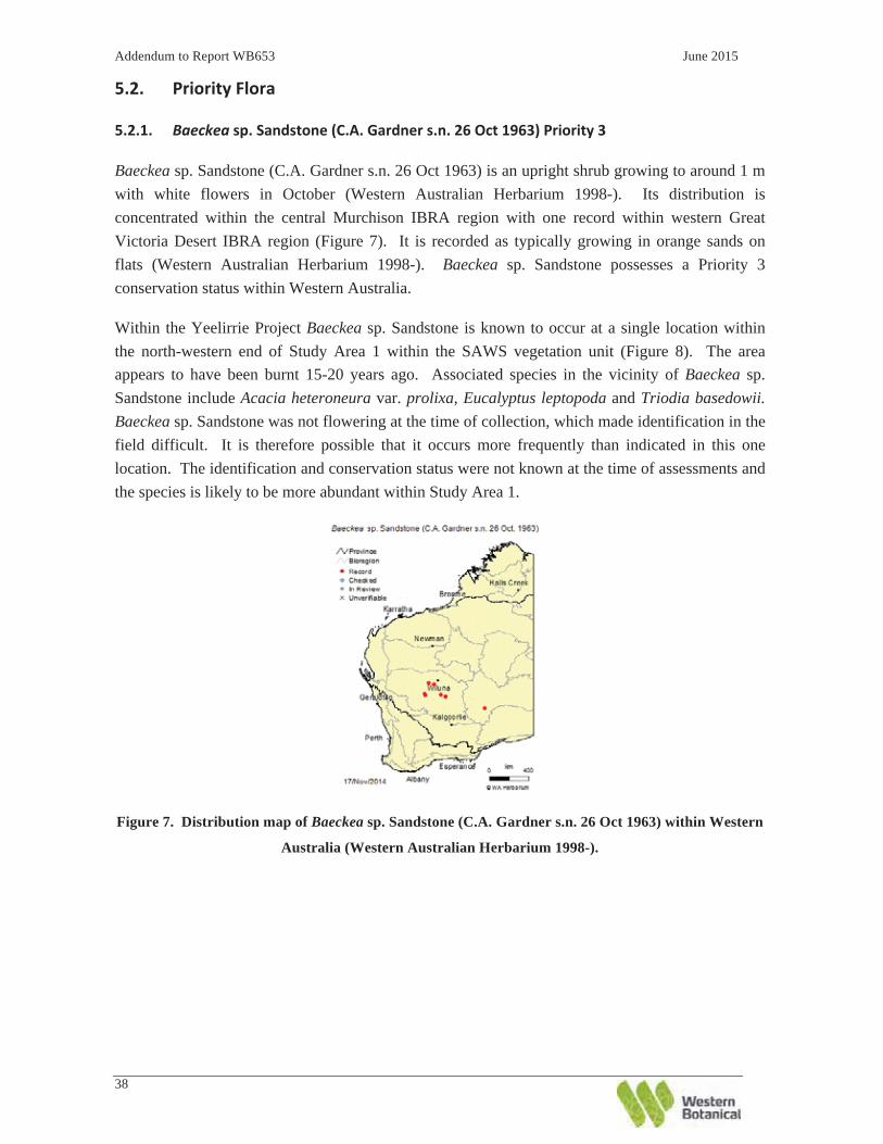
Baeckea sp. Sandstone (C.A. Gardner s.n. 26 Oct 1963) is an upright shrub growing to around 1 m with white flowers in October (Western Australian Herbarium 1998-). Its distribution is concentrated within the central Murchison IBRA region with one record within western Great Victoria Desert IBRA region (Figure 7). It is recorded as typically growing in orange sands on flats (Western Australian Herbarium 1998-). Baeckea sp. Sandstone possesses a Priority 3 conservation status within Western Australia.
Within the Yeelirrie Project Baeckea sp. Sandstone is known to occur at a single location within the north-western end of Study Area 1 within the SAWS vegetation unit (Figure 8). The area appears to have been burnt 15-20 years ago. Associated species in the vicinity of Baeckea sp. Sandstone include Acacia heteroneura var. prolixa, Eucalyptus leptopoda and Triodia basedowii. Baeckea sp. Sandstone was not flowering at the time of collection, which made identification in the field difficult. It is therefore possible that it occurs more frequently than indicated in this one location. The identification and conservation status were not known at the time of assessments and the species is likely to be more abundant within Study Area 1.
Figure 7. Distribution map of Baeckea sp. Sandstone (C.A. Gardner s.n. 26 Oct 1963) within Western
Australia (Western Australian Herbarium 1998-).

Addendum to Report WB653 June 2015
39
Figure 8. Records of Baeckea sp. Sandstone (C.A. Gardner s.n. 26 Oct 1963), Priority 3, within and
near local Study Areas (1, 2, and 3) at Yeelirrie.


Addendum to Report WB653 June 2015
42
Figure 9. Distribution map of Bossiaea eremaea within Western Australia (Western Australian
Herbarium 1998-).

Addendum to Report WB653 June 2015
43
Figure 10. Records of Bossiaea eremaea, Priority 3, within and near local Study Areas (1, 2, and 3) at
Yeelirrie.


Addendum to Report WB653 June 2015
46
Figure 12. Records of Calytrix uncinata, Priority 3, within and near local Study Areas (1, 2, and 3) at
Yeelirrie.


Addendum to Report WB653 June 2015
48
Comesperma viscidulum is a low shrub growing to 0.7 m and has stem-clasping leaves with pronounced recurved tips (Plate 5). Its distribution is scattered within central Western Australia, forming disjunct distribution groupings (Figure 13). Comesperma viscidulum has a Priority 4 conservation status within Western Australia.
Specimens found within the Yeelirrie Project and reported in WB653 represented a range extension of ~150 km and a new record for the Murchison IBRA region. Following the lodgement of voucher specimens to the Western Australian Herbarium, Comesperma viscidulum is no longer considered a range extension for the Yeelirrie Project.
Comesperma viscidulum occurs within the SAMA vegetation unit of the north-west section of the Yeelirrie Project, but outside of the footprint (Figure 14). Isolated plants were found in very low numbers (23 in total) near roadside bunds at the junction of Wiluna-Sandstone Road and Meekatharra Road, and along these roads north and west of the junction. It is typically found in low numbers amongst Spinifex and mallee on red sandplains (G. Cockerton pers. obs.).
Plate 5. Photos of Comesperma viscidulum showing growth habit and leaf features (Australian
Herbarium 1998-).

Addendum to Report WB653 June 2015
49
Figure 13. Distribution map of Comesperma viscidulum within Western Australia (Western
Australia).

Addendum to Report WB653 June 2015
50
Figure 14. Records of Comesperma viscidulum, Priority 4, within and near local Study Areas (1, 2,
and 3) at Yeelirrie.


Addendum to Report WB653 June 2015
52
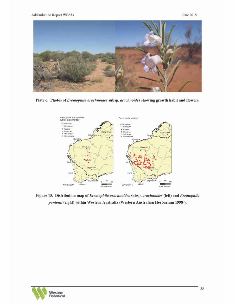
Eremophila arachnoides subsp. arachnoides was reported as a Priority Flora in WB653. Eremophila arachnoides subsp. arachnoides is morphologically very similar to E. pantonii (not of conservation significance), differing in fruit and minor leaf and stem characteristics. The most reliable character for differentiating the two species is the fruit which is most abundant in late spring / early summer.
Eremophila arachnoides subsp. arachnoides is a tall broom-like shrub, growing to 3 m, has branches with circular discrete tubercles, and white/blue-purple flowers in September (Western Australian Herbarium 1998-) (Plate 6). Its distribution is primarily in the Murchison IBRA region with a record also in the Little Sandy Desert IBRA region (Figure 15). It typically grows on shallow loam soil over limestone (Western Australian Herbarium 1998-). Eremophila arachnoides subsp. arachnoides has a Priority 3 conservation status within Western Australia.
Eremophila arachnoides subsp. arachnoides and E. pantonii both prefer alkaline soils, have overlapping distributions though the latter is far more widely distributed (Figure 15). Meissner (2011) reported E. pantonii and E. arachnoides subsp. arachnoides within the lake systems they assessed with no overlap in the distribution of these two species. E. pantonii was reported at Lake Darlot, L. Maitland, and L. Miranda while E. arachnoides subsp. arachnoides was reported at Lake Mason, Lake Way, and Yeelirrie. Western Botanical recommends the collection of fruiting material of E. arachnoides subsp. arachnoides at the Yeelirrie Project and confirmation of the identification.
Within the Yeelirrie Project Eremophila arachnoides subsp. arachnoides occurs almost exclusively on the Calcrete System (Figure 16). Scattered individuals were also recorded within the Playa and Sand Plain Systems. Intensive searches (50 m traverses, 200 m apart, within Study Area 1) performed by Western Botanical found that populations are evident on the majority of exposed calcrete. The total population is approximated to be 43,255 plants, based on counts of approximately 25% of the population. The densest portion of the Eremophila arachnoides subsp. arachnoides population occurs in the Casuarina pauper Woodland on Calcrete (CCpW) vegetation unit. Scattered individuals were recorded within CEgW, CAbS, CErG, CLaS, CMGbS, CMxS, CRsS, HPMS, PLAPoS and PLAET vegetation units and associated mosaics.

Addendum to Report WB653 June 2015
54
Figure 16. Records of Eremophila arachnoides subsp. arachnoides, Priority 3, within and near local
Study Areas (1, 2, and 3) at Yeelirrie.


Addendum to Report WB653 June 2015
56
Euryomyrtus inflata is a small long-live shrub with a lignotuber growing 0.3 to 0.7 m high, flat dull blue-green leaves (Plate 7) which turn red during times of moisture stress. It has erect rounded fruits with three carpels, each with a single seed per locule. Flowers are white to pink and occur during June and July (Western Australian Herbarium 1998-). Euryomyrtus inflata has a Priority 3 conservation status within Western Australia.
Euryomyrtus inflata is distributed within a discreet portion of the central Murchison IBRA region (Figure 17). It is typically found on flat plains of deep red sand (Western Australian Herbarium 1998-).
Within the Yeelirrie Project Euryomyrtus inflata occurs in extensive populations within the Sand Plain System of Study Area 1 (Figure 18). Records of individual plants are shown as points and, where populations were extensive, a population boundary was inferred. The largest populations were identified in the north-west region of study area 1. These were primarily on the northern side of the Calcrete System in the more recently burnt SAWS and SAMA vegetation units. The largest population of E. inflata within Study Area 1 extends for approximately 15 km north-west to south-east, and three km north-east to south-west along the northern side of Study Area 1, adjacent to the Calcrete System in the north-western part of Study Area 1. An extensive population also exists on the southern side of the Calcrete System in the SASP vegetation unit. On the southern side of Study Area 1 the population extends for 10 km north-west to south-east and two km north-east to south-west. Large populations of E. inflata were also present in the eastern region of Study Area 1, including two in the Sand Plain System. Scattered individuals were also recorded adjacent to the access road. Individual plants were present in varying densities, from approximately 10 plants per 50 m2 (40 per ha) to 350 plants per 50 m2 (1400 per ha). The number of plants estimated to occur within Study Area 1 is 134,520.
Euryomyrtus inflata is most commonly found in high numbers in areas burnt approximately five years ago. It occurs on flat sandplains and lower lying sandy areas, in SAWS, SAMA and SASP vegetation communities, and where Triodia basedowii has no more than 25% foliage cover. Euryomyrtus inflata is also present in communities that have remained unburnt for at least 15-20 years, however, plants are larger and less frequent. It is predicted that this species would also occur in the very recently burnt areas (within one to three years) given time for it to regenerate after fire.

Addendum to Report WB653 June 2015
57
Plate 7. Photos of Euryomyrtus inflata showing growth habit (lower left of first photo) and brach and
leaf arrangement.
Figure 17. Distribution map of Euryomyrtus inflata within Western Australia (Western Australian
Herbarium 1998-).

Addendum to Report WB653 June 2015
58
Figure 18. Records of Euryomyrtus inflata, Priority 3, within and near local Study Areas (1, 2, and 3)
at Yeelirrie.

Addendum to Report WB653 June 2015
60
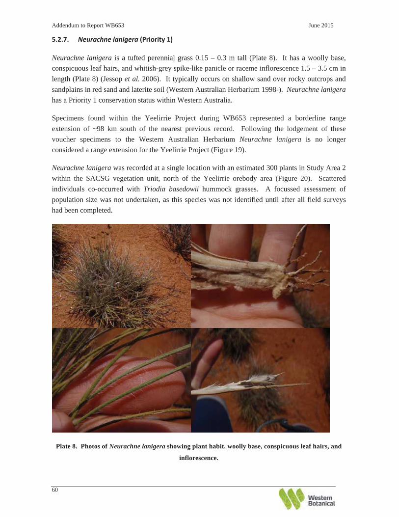
Neurachne lanigera is a tufted perennial grass 0.15 – 0.3 m tall (Plate 8). It has a woolly base, conspicuous leaf hairs, and whitish-grey spike-like panicle or raceme inflorescence 1.5 – 3.5 cm in length (Plate 8) (Jessop et al. 2006). It typically occurs on shallow sand over rocky outcrops and sandplains in red sand and laterite soil (Western Australian Herbarium 1998-). Neurachne lanigera has a Priority 1 conservation status within Western Australia.
Specimens found within the Yeelirrie Project during WB653 represented a borderline range extension of ~98 km south of the nearest previous record. Following the lodgement of these voucher specimens to the Western Australian Herbarium Neurachne lanigera is no longer considered a range extension for the Yeelirrie Project (Figure 19).
Neurachne lanigera was recorded at a single location with an estimated 300 plants in Study Area 2 within the SACSG vegetation unit, north of the Yeelirrie orebody area (Figure 20). Scattered individuals co-occurred with Triodia basedowii hummock grasses. A focussed assessment of population size was not undertaken, as this species was not identified until after all field surveys had been completed.
Plate 8. Photos of Neurachne lanigera showing plant habit, woolly base, conspicuous leaf hairs, and
inflorescence.

Addendum to Report WB653 June 2015
61
Figure 19. Distribution map of Neurachne lanigera within Western Australia (Western Australian
Herbarium 1998-).

Addendum to Report WB653 June 2015
62
Figure 20. Records of Neurachne lanigera, Priority 1, within and near local Study Areas (1, 2, and 3)
at Yeelirrie.


Addendum to Report WB653 June 2015
64
Olearia arida is an erect shrub to 0.5 m with discolorous (due to abaxial surface hairs) and slightly crenulate leaves (Plate 9). It typically occurs on undulating low rises of red or yellow sand (Western Australian Herbarium 1998-) (Figure 21). Olearia arida has a Priority 4 conservation status within Western Australia.
Prior to WB653 Olearia arida was known only to occur in the south-western portion of the Great Victoria Desert IBRA region. Specimens found within the Yeelirrie Project during WB653 represented a disjunct range extension of ~400 km and a new record for the Murchison IBRA region. Following the lodgement of voucher specimens to the Western Australian Herbarium, Olearia arida is no longer considered a range extension for the Yeelirrie Project.
Two subpopulations of Olearia arida were found on the roadside of the Yeelirrie – Albion Downs Road approximately 15 km west of the intersection with the Goldfields Highway, outside of the project footprint (Figure 22). The two subpopulations are within the SAWS and SAMA vegetation communities in the Sand Plain System.
Plate 9. Photo of Olearia arida showing leaf structure and flower.

Addendum to Report WB653 June 2015
65
Figure 21. Distribution of Olearia arida within Western Australia (Western Australian Herbarium
1998-).

Addendum to Report WB653 June 2015
66
Figure 22. Records of Olearia arida, Priority 4, within and near local Study Areas (1, 2, and 3) at
Yeelirrie.


Addendum to Report WB653 June 2015
70
Figure 24. Records of Rhagodia sp. Yeelirrie Station (K.A. Shepherd et al. KS1396), Priority 1, within
and near local Study Areas (1, 2, and 3) at Yeelirrie.


Addendum to Report WB653 June 2015
72
Sauropus ramosissimus is a slender, much-branched shrub, growing to 0.3 m (Western Australian Herbarium 1998-) (Plate 11). It is often heavily grazed by wildlife and stock and therefore may be difficult to observe. Flowers are small and green in colour and occur following spring rainfall. Sauropus ramosissimus possesses a Priority 3 conservation status within Western Australia.
Sauropus ramosissimus distribution is scattered across eastern states of Australia and in Northern Territory. In Western Australia it is found primarily in the Murchison IBRA region with a record each in the Gascoyne, Gibson Desert, and Great Victorian Desert IBRA regions. The FloraBase distribution map (Western Australian Herbarium 1998-) for Sauropus ramosissimus does not match distributions records. As such, the Australian Virtual Herbarium (Council of Heads of Australasian Herbaria 2014) distribution map is provided in Figure 25. It is recorded growing on rocky ironstone and laterite outcrops, slopes, and flats in orange or red loamy sand (Western Australian Herbarium 1998-).
Two populations of S. ramosissimus were recorded within Study Area 2 (Figure 26). One population of ten plants was recorded on low granite outcrops in the central-northern margins of Study Area 2 in the GRMS vegetation unit. The second population was found top of a small weathered granite breakaway plateau in the WGBP vegetation unit (within the BRX unit).
Plate 11. Photos of Sauropus ramosissimus showing growth habit and branch and stem habit.

Addendum to Report WB653 June 2015
73
Figure 25. Distribution map of Sauropus ramosissimus in Western Australia (Council of Heads of
Australasian Herbaria 2014).

Addendum to Report WB653 June 2015
74
Figure 26. Records of Sauropus ramosissimus, Priority 3, within and near local Study Areas (1, 2, and
3) at Yeelirrie.


Addendum to Report WB653 June 2015
76
Since WB653, Sida sp. Mt Keith (G. Cockerton & G. O’Keefe LCH 10489) has been included within the newly described species Sida picklesiana, a Priority 3 taxon (see Markey et al. 2011).
Sida picklesiana is a woody perennial shrub, 0.4 – 1.0 (-1.5) m high and 0.8 – 1.0 (-1.2) m wide, growing with a compact, rounded, densely branched twiggy habit (Markey et al. 2011) (Plate 12). Leaves are 0.6-1.2 mm long by 0.4-0.7 mm wide with crenulate margins (Plate 12). It typically grows in deep to skeletal sandy clay and sandy clay loam on exposed rocky habitats including hills, granite breakaways, footslopes of banded iron formations, and associated stony plains (Markey et al. 2011). Sida picklesiana is primarily distributed south of Wiluna in the Murchison IBRA region and near Doolgunna Station in the Gascoyne IBRA region (Figure 27).
At the Yeelirrie Project a single population containing 397 individuals of Sida picklesiana was found within Study Area 2 (Figure 28). They were growing along both the slopes and plateaux within the WGBP vegetation unit (part of the Archaean granite Breakaway (BRX) complex) and the Acacia shrubland of the WGAG vegetation unit.
Plate 12. Photos of Sida picklesiana showing growth habit, leaves and flower.
Figure 27. Distribution map of Sida picklesiana within Western Australia (Western Australian
Herbarium 1998-).

Addendum to Report WB653 June 2015
77
Figure 28. Records of Sida picklesiana, Priority 3, within and near local Study Areas (1, 2, and 3) at
Yeelirrie.


Addendum to Report WB653 June 2015
79
Thryptomene sp. Leinster (B.J. Lepschi & L.A. Craven 4362) is an upright to sprawling shrub up to 2.5 m in height, producing white to pink flowers from October to December (Plate 13). It is recorded occurring on rocky Archaean granite breakaways, stony rises, and rocky granite outcroppings in association with Acacia aneura sens. lat. (Western Australian Herbarium 1998-). Since WB653 the conservation status of Thryptomene sp. Leinster (B.J. Lepschi & L.A. Craven 4362) has been downgraded from Priority 1 to Priority 3 in Western Australia.
Known from a narrow distribution in the eastern Murchison Biogeographic region, there are currently 15 voucher collections listed on FloraBase (Western Australian Herbarium 1998-) (Figure 29). Thryptomene sp. Leinster is associated with the Barr-Smith Range, which extends from the south of Wiluna to approximately 60 km south of Leinster and is often plentiful within it’s known range.
Thryptomene sp. Leinster has previously been referred to as the closely related species T. decussata, but differs in morphology with the following attributes; a) leaves are smaller and of a different shape – leaves are very broad ovate to sub-orbicular in shape with a truncate base, b) oil glands on the leaves are more closely packed, and c) difference in anther arrangement (Malcolm Trudgen pers. comm.).
A single population of 168 plants was recorded on a Quartz ridge in the central north-western part of the Study Area 2 (Figure 30) within the Qtz (Quartz Ridge) vegetation unit. Similar quartz ridges in Study Area 2 did not support T. sp. Leinster.
Plate 13. Photos of Thryptomene sp. Leinster (BJ. Lepschi & L.A. Craven 4362) showing growth
habit, leaf arrangement, and flowers.

Addendum to Report WB653 June 2015
80
Figure 29. Distribution map of Thryptomene sp. Leinster (B.J. Lepschi & L.A. Craven 4362) within
Western Australia (Western Australian Herbarium 1998-).

Addendum to Report WB653 June 2015
81
Figure 30. Records of Thryptomene sp. Leinster (B.J. Lepschi & L.A. Craven 4362), Priority 3, within
and near local Study Areas (1, 2, and 3) at Yeelirrie.


Addendum to Report WB653 June 2015
83
Locations of all Flora of Interest (presented in the subheadings below) found at the Yeelirrie Project are mapped in Figure 31.

Addendum to Report WB653 June 2015
84
Figure 31. Recorded locations of Flora of Interest in and around Study Areas 1, 2, and 3.


Addendum to Report WB653 June 2015
86
Acacia sp. (G. Cockerton & R. Graham LCH 25491) was presented in WB653 and is precautionarily retained as a Flora of Interest for this addendum revision. It is a tree 6 - 8 m high (Plate 14), with flat phyllodes that are slightly curved, 2 x 130 mm, yellow-green in colour, with a large amount of resin. The tree has rough grey bark, brittle branchlets, and timber with a dark centre. During WB653 it did not key to any known Acacia species and fruits and flowers are required to be collected for further identification.
With the revision of mulgas (Acacia aneura sens. lat.) in 2012 (Maslin & Reid), Acacia sp. (G. Cockerton & R. Graham LCH 25491) may now fall within a recognised taxon. Clarification of this species identity would require collection of further flowering and fruiting material. As reported in WB653, this species is not considered to be of conservation significance and was not recorded in the proposed project footprint. This Acacia was recorded in a population of 50 plants that formed a grove in SAMU vegetation unit located approximately 4 km north-west of the Yeelirrie Homestead (Figure 31). Associated species were A. ayersiana, A. ramulosa var. linophylla and Triodia basedowii.
Plate 14. Photo of Acacia sp. (G. Cockerton & R. Graham LCH 25491) showing growth habit.
Acacia sp. resprouter (G. Cockerton & R. Graham LCH 25490) was presented in WB653 and is precautionarily retained as a Flora of Interest for this addendum revision. It is a shrub to 1.7 m high that resprouts at the base from lignotuber after fire. It was recorded as a dominant Acacia in one area of SAWS vegetation unit north of Three Mile Well on Yeelirrie Station and is associated with Hakea lorea subsp. lorea, Triodia basedowii and T. melvillei (Plate 15). Acacia sp. resprouter (G. Cockerton & R. Graham LCH 25490) has affinities with A. coolgardiensis subsp. coolgardiensis and A. resinosa. Further investigation of flowering and fruiting material is needed to determine its identity. Western Botanical has also noted a small population of this Acacia

Addendum to Report WB653 June 2015
87
occurring at Lake Way Station. It is not considered to be of conservation significance. A map showing its distribution within the local Study Area is provided in Figure 31.
Plate 15. Photos of Acacia sp. resprouter (G. Cockerton & R. Graham LCH 25490) showing habit
within SAWS vegetation unit (left) and leaf arrangement (right).
Acacia sp. Yakabindie (G. Cockerton & G. O’Kefe LCH 14274) aff. kempeana was presented in
WB653 and is precautionarily retained as a Flora of Interest for this addendum revision.
It grows as a large shrub to 4 m with striking, characteristic, yellow-green and highly fragrant
foliage (Plate 16). The species has many similarities to the widespread Acacia kempeana, but the
golden-brown phyllode resin and terminal stems give the plant a characteristic yellow-green colour
and a strong cinnamon-honey fragrance. This strongly contrasts with A. kempeana that is blue-
green in colour and has no noted fragrance. The phyllode shape is similar to A. kempeana;
however, differs in venation and resin characteristics (Plate 16).
Overall, approximately 447 plants in 11 populations are known primarily from Yakabindie Station,
approximately 100 km south of Wiluna. It is also known from the Pilbara region where it has been
widely collected. Scattered individuals have been noted by Western Botanical on Yakabindie
Station (Dingo Creek), Albion Downs borefield (near Bore 6) and north-east of Mt Keith Nickel
Operation.
One plant was recorded in Study Area 1 in SAMA vegetation east of proposed high-grade
stockpile, and a single population of approximately 30 plants in Study Area 2, also in the SAMA
vegetation unit. Another individual plant was recorded on the northern boundary of the survey area
within the GPoS vegetation unit. Locations of plants within the local study areas are presented in


Addendum to Report WB653 June 2015
89
Eragrostis tenellula is a caespitose, erect to semi-prostrate annual grass, 0.06 to 0.5 (1.3) m tall Western Australian Herbarium 1998-) (Plate 17). It is widespread across Australia and common in the north and northwest of Western Australia (Figure 33). It typically occurs on clay, lateritic or basalitic loam, and yellow sand on seasonally flooded sites and banks/beds of watercourses (Western Australian Herbarium 1998-).
The occurrence of Eragrostis tenellula at the Yeelirrie Project represents a southward range extension of ~152 km (Western Australian Herbarium 1998-). However, Australia’s Virtual Herbarium (Council of Heads of Australasian Herbaria 2014) has additional records indicating a 112 km southwards range extension. It occurs infrequently within the local Project Area on in depressions or shallow playas within the PLEmc and PLCsMp vegetation units (Figure 31).
Plate 17. Photo of Eragrostis tenellula (Simon & Alfonso 2014, photo by E. Anderson) showing typical
growth habit.
Addendum to Report WB653 June 2015
91
Figure 34. Distribution map of Euphorbia biconvexa within Western Australia (Western Australian
Herbarium 1998-).
Hibbertia sp. aff. exasperata (D. Brassington & S. Colwill LCH 29097) is an erect shrub to 1.2 m high with pungent, green leaves (Plate 19). This species is restricted to the Archaean granite breakaway system, which is a part of the Sherwood Land System.
Hibbertia sp. aff. exasperata is currently considered to be a part of the H. exasperata group of at least four to five closely related species (Wheeler 2004). Further collections of reproductive material and a review of the H. exasperata sens. lat. group are required to determine its taxonomic status. The distribution of Hibbertia exasperata, which H. sp. aff. exasperata has affinity to, is presented in Figure 35.
The population on the Barr-Smith Range in the Yeelirrie – Mt Keith – Yakabindie region, within the central Murchison IBRA region represents an approximately 372 km northerly range extension for this species from Mt Jackson in the northern Coolgardie region and an approximately 378 km north-easterly range extension from Mt Gibson in the northern Avon-Wheatbelt region. The occurrence of this species complex in the Murchison IBRA region is novel.
Within the Yeelirrie Project, one population of 71 individuals of Hibbertia sp. aff. exasperata was recorded within the BRX complex on the breakaways of the Barr-Smith Range in the northern section of Study Area 2 (Figure 31). This population may extend beyond the boundary of Study Area 2 in association with the breakaway system. Western Botanical also knows this species from the same landform existing 20 km south-east of this site, within the same Barr-Smith Range, on Yakabindie Station.
The collection of good flowering and fruiting material is required for the taxonomy of this species to be clarified.

Addendum to Report WB653 June 2015
92
Plate 19. Photos of Hibbertia sp. aff. exasperata (D. Brassington & S. Colwill LCH 29097) showing
growth habit and leaf arrangement.
Figure 35. Distribution map of Hibbertia exasperata within Western Australia (Western Australian
Herbarium 1998-).
Mollugo cerviana is an erect, ephemeral, annual herb growing 0.03 to 0.2 m high with white flowers (Western Australian Herbarium 1998-). It is sparsely distributed across Western Australia with ten collections held by Western Australian Herbarium (Figure 36). It typically occurs on saline sand and sandy clay on sand dunes and edges of salt lakes (Western Australian Herbarium 1998-). The occurrence of Mollugo cerviana at the Yeelirrie Project (Figure 31) represents a range extension of ~385 km from the nearest recorded collection, though within the overall range of the sparse collections made of this species in WA.

Addendum to Report WB653 June 2015
93
Figure 36. Distribution map of Mollugo cerviana within Western Australia (Western Australian
Herbarium 1998-).
Olearia sp. Sherwood Breakaways (A. Taylor LCH 25552) was reported in WB653 as a novel species. Formal recognition of this species has not occurred since WB653; it is retained as a Flora of Interest in this addendum revision as a precaution for possible future recognition.
Olearia sp. Sherwood Breakaways (A. Taylor LCH 25552) is a small, sparse, and obnoxiously fragrant shrub to 0.6 m high. It has an upright habit with few branches, producing white to pale purple flowers with yellow centres following spring rainfall (Plate 20). This species has affinities to O. stuartii but has multiple distinct differences:
• Olearia sp. Sherwood Breakaways is highly fragrant whereas O. stuartii has no fragrance; • The capillary bristles of Olearia sp. Sherwood Breakaways are larger than the bracts,
whereas the capillary bristles of O. stuartii are the same length as the bracts; • The leaves of Olearia sp. Sherwood Breakaways are shorter and narrower than the leaves of
O. stuartii; • Olearia sp. Sherwood Breakaways have noticeably more glandular hairs on its foliage than
that of O. stuartii; and • Olearia sp. Sherwood Breakaways leaves are lobed at the ends, whereas O. stuartii leaves
have lobed sides.
Olearia sp. Sherwood Breakaways is very restricted in its habitat preference, occurring in small,
disjunct populations on breakaways of the Barr-Smith Range in the local region, with one
population noted on Banded Ironstones at the Brooking Hills. Olearia sp. Sherwood Breakaways
is also known from small, disjunct populations elsewhere on the breakaway plateau of the Barr-
Smith Range on Mt Keith, Albion Downs and Yakabindie Stations. Should the conservation status

Addendum to Report WB653 June 2015
94
of this species be reviewed, based on the known numbers of individuals and distribution of
populations, the species would potentially qualify as a priority species.
A preliminary review undertaken by the Western Australian Herbarium (S. Dillon pers. comm. 22/12/2014) revised Olearia stuartii specimens held at the Western Australian Herbarium. The relevant preliminary findings included: (i) numerous misidentifications of O. stuartii and O. humilis, (ii) recognition of a new species referred to as the non-viscid BIF entity and here as Olearia sp. Yilgarn BIF (G. Cockerton et. al. s..n.), and (iii) a new species referred to as the viscid BIF entity and here as Olearia sp. Sherwood Breakaways (A. Taylor LCH 25552). Further work is required to fully elucidate the complex taxonomy of the Olearia stuartii group.
At the Yeelirrie Project a population (70 individuals) of Olearia sp. Sherwood Breakaways was
found on a small plateau in the Weathered Granite Plateau (WGBP) community of the BRX
complex (Figure 31).
Plate 20. Photos of Olearia sp. Sherwood Breakaways (A. Taylor LCH 25552) showing growth habit,
leaf detail, and flowers.

Addendum to Report WB653 June 2015
95
As reported in WB653 Prostanthera sp. Bullimore Sandplain (G. Cockerton & D. True 12813) still remains curated within Prostanthera althoferi subsp. althoferi. However, Prostanthera sp. Bullimore Sandplain has been precautionarily retained in this addendum revision as a Flora of Interest.
WB653 reported that at least two taxa exist within Prostanthera althoferi subsp. althoferi collection at the Western Australian Herbarium. The two forms differ slightly in leaf size and morphology and have major differences in growth habit and habitat preference. Western Botanical has tentatively applied the phrase name Prostanthera sp. Bullimore Sandplain (G. Cockerton & D. True LCH 12813) to the taxon recorded in Study Area 1 and elsewhere on the sand plains of the Murchison BGR, including Yeelirrie, to distinguish it from typical P. althoferi subsp. althoferi on the rocky hills further to the south-west in the Coolgardie IBRA region. As the taxonomic review has not yet been conducted, this phrase name has not yet been accepted within the Western Australian Herbarium and does not appear on the Census of Vascular Flora. Neither form of Prostanthera althoferi subsp. althoferi warrants conservation significance, as both species curated under P. althoferi subsp. althoferi are considered common and widespread. It is discussed here as it is of taxonomic interest only and to recognise that a revision of this genus is required.
The ‘Type’ (true form) of Prostanthera althoferi subsp. althoferi is a low, dense, divaricately shrub to 1 m high by 1.5 m wide and grows on the rocky outcrops and banded ironstone (BIF) and chert hills and limonitic gravely plains in the Yilgarn and south-western part of the North-eastern Goldfields (Figure 37).
Prostanthera sp. Bullimore Sandplain (G. Cockerton & D. True LCH 12813) is a shrub to 2 m high by 2 m wide (Plate 21) and grows exclusively on the Aeolian orange sand plains of the Bullimore land system in the North-eastern Goldfields and Central Desert (Western Botanical, 2008c).
Prostanthera sp. Bullimore Sandplain was recorded within the Sand Plain System on the northern and southern roadsides of the Yeelirrie Albion Downs Road approximately 20 km west of the Yeelirrie Albion Downs Road and Goldfields Highway intersection. A map showing its distribution at Yeelirrie is provided in (Figure 31). A total of 335 individuals were recorded within a 500 m wide buffer, 250 m either side of the current road alignment. A single individual was also recorded near the junction of the Sandstone Wiluna Road and Meekatharra Road. It occurs within the SASP, SAMA, SAGS and SAWS vegetation communities with Acacia effusifolia, Eremophila forrestii subsp. forrestii, Leptosema chambersii and Triodia basedowii (dominant).
Addendum to Report WB653 June 2015
97
Area 1, and (iii) Lake Miranda, south-east of Albion Downs Station. All three populations are within the Yeelirrie paleodrainage system. Areas of sparse populations were found within the Sand Plain and Playa Systems of Study Area 1, while the densest populations were recorded north of the airstrip (Figure 31). In total, 782 individuals were recorded. The taxon occurs within the SAWS, SAMU, HPMS, WABS, PLAPoS, PLAET, PLAMi, PLEmc, PLEml, PLEsp, CMxS, CEgW, CErG, CLaS, CMGbS, CMiS and CMpS vegetation units.
The group known as Scaevola spinescens requires further taxonomic differentiation of the several morhpologically distinct entities contained. The group known as Scaevola spinescens in the broad sense (sens. lat.) is widely distributed across the state, occurring in 18 Biogeographic regions, and is recognised as requiring taxonomic revision (L. Sage pers. comm. 2008) (Figure 38). There are at least five forms of S. spinescens that, in the opinion of the author, could be separated at the sub-species level. These are:
• Pilbara form - little known by the author of this form; • Broad leaf, non-spinescent form associated with granitoid, often saline landforms, salt lake
margins and gypsiferous dunes; • Narrow leaf, very spinescent form associated with limonitic landforms in the North-eastern
goldfields and on the banded ironstone ranges of the Yilgarn region; • Terete leaf, spinescent form - associated with calcrete, shallow sandsheet over calcrete and
margins of claypans in the Yeelirrie – Lake Miranda palaeodrainage; and • Recurved branch form - noted at Shark Bay.
The broad leaf, non-spinescent form; narrow leaf, spinescent form; and terete leaf, spinescent forms have been found to occur on different soils and geology within Study Area 1. The broad leaf form (mostly non-spiny) is common in the understory of Casuarina pauper woodlands on calcrete. The narrow leaf, spiny form is found infrequently as scattered individuals within the Playa and Sand Plain Systems. This form is very abundant and common on the limonitic landforms east of the survey area near Mt Keith and Leinster. Neither of these two forms have conservation significance.
Locations of these forms are only indicative at this stage and should not be taken as the full extent of occurrence. The Western Australian Herbarium and Leigh Sage (DPaW, Goodeniaceae specialist) are currently involved in conducting taxonomic investigations into the S. spinescens group.
Western Botanical has recorded and identified herbarium collections of Scaevola spinescens terete leaf form at Yeelirrie (Figure 31) and surrounding areas of the northeast goldfields (Figure 39). Scaevola spinescens (unspecified forms) was reported by Meissner 2011 in surveys of the Calcrete paleochannels of the north-eastern Goldfields. Records were at Lake Darlot, Lake Maitland, Lake Mason, Lake Miranda, Lake Way, Nowathana and Yeelirrie. Many of these may prove to be Scaevola spinescens terete leaf form.


Addendum to Report WB653 June 2015
99
Figure 39. Western Botanical records and select Western Australian Herbarium records of Scaevola
spinescens terete leaf form (G. Cockerton & C. Ringrose LCH 14560) in the north-eastern Goldfields.
Sporobolus australasicus is an annual/ephemeral grass with an oblong or pyramidal compound inflorescence (Simon & Alfonso 2014) (Plate 23). It is widespread across northern Australia with some records southward approaching Wiluna (Figure 40). The grass typically occurs on loam, clay, sand, and limestone on coastal samphire flats, floodplains, and rocky rises (Western Australian Herbarium 1998-).
The occurrence of Sporobolus australasicus at the Yeelirrie Project (Figure 31) represents a southwards range extension of ~175 km (Western Australian Herbarium 1998-). However, Australia’s Virtual Herbarium (Council of Heads of Australasian Herbaria 2014) has additional records indicating a ~131 km range extension. Sporobolus australasicus was recorded at one location on brown sandy-clay-loam with calcrete within the CLaS vegetation unit.

Addendum to Report WB653 June 2015
100
Plate 23. Photo of Sporobolus australasicus (Simon & Alfonso 2014, photo by D. Albrecht) showing its
growth habit.
Figure 40. Distribution of Sporobolus austrolasicus within Western Australia (Western Australian
Herbarium 1998-).
Tribulus sp. LCH 27811 is a taxon found subsequent to report WB653. It was recorded at Quadrat YQS081 (50J 82898 mE, 6994057 mN) within the PLAET community (Figure 31). It was recorded as having similarities to T. suberosus. However, this is a distinctive and shrubby species of stony hills. This taxon requires recollection and review of its identification.

Addendum to Report WB653 June 2015
101
Vittadinia dissecta var. hirta is an erect, much-branched, viscid annual or perennial, short-lived herb, 0.1-0.4 m high (Western Australian Herbarium 1998-) (Plate 24). It is widespread across Australia and has an unusual distribution in Western Australia split into four disjunct areas (Figure 41). Vittadinia dissecta var. hirta is recorded to occur on sandy clay or loam and alluvium on flats, claypans, and marine plains (Western Australian Herbarium 1998-).
At Yeelirrie, Vittadinia dissecta var. hirta occurs in the rehabilitated southern Stockpile area (Figure 31). The occurrence of Vittadinia dissecta var. hirta at the Yeelirrie Project represents a range extension of ~340 km from the nearest record to the south-east (Western Australian Herbarium 1998-). However, Australia’s Virtual Herbarium (Council of Heads of Australasian Herbaria 2014) has several additional records indicating a ~312 km range extension from the north-west (Figure 41).
The combination of disjunct populations, variable habitats, and significant range extensions indicates an appreciable uncertainty in the taxonomy of this species. Revision of Vittadinia is needed (Mike Hislop 2014, pers. comm. Oct. 2014) and would likely result in the recognition of additional taxa.
Plate 24. Photo of Vittadinia dissecta var. hirta (Council of Heads of Australasian Herbaria 2014,
photo Don Wood).

Addendum to Report WB653 June 2015
102
Figure 41. Distribution maps of Vittadinia dissecta var. hirta (Western Australian Herbarium 1998-
(left), Council of Heads of Australasian Herbaria 2014 (right).


Addendum to Report WB653 June 2015
104
(reference 39-0211), was performed to recheck for the presence of TECs and PECs within and near the Yeelirrie project.
As for the previous search, no flora-related TECs or PECs listed for calcrete assemblages were found to occur within the vicinity of the local study area. Similarly, the search returned the same instances of Priority 1 PEC communities associated with Banded Ironstone Formations, but none occur within the Local Study Areas of the Yeelirrie Project, and these are not discussed further.
Addendum to Report WB653 June 2015
105
This addendum report provides the addition of a Vegetation Condition map of the Local Study Area (areas 1, 2, and 3), (Figure 42). Vegetation condition was based on the Keighery (1994) scale (as presented in Government of Western Australia 2000) (Appendix 5) using information within WB653 and using aerial imagery. No additional fieldwork beyond WB653 was performed, and the vegetation condition map is considered current as at February 2011.
Due to a history of pastoral management and grazing, the majority of the vegetation within the Local Study Area is of ‘excellent’ condition rather than ‘pristine’, on the Keighery scale. The area immediate surrounding the Yeelirrie homestead and the airstrips is considered ‘degraded’, improving to ‘good’ with distance from the homestead. Within the mining footprint, exploration activities and some weed incursion have reduced the vegetation condition to ‘good’, with exploration tracks and roads and some isolated patches previously completely cleared having a condition of ‘degraded’. As Atriplex sp. Yeelirrie Station (L. Trotter & A. Douglass 25025) is preferentially grazed (predominantly cattle), areas supporting this species in the Eastern Population are of a lower ‘degraded’ vegetation condition.
Importantly, the vegetation condition map (Figure 42) does not present individual roads and tracks as separate vegetation condition polygons. Generally, within the Local Study Area, the vegetation condition of ungraded vehicle tracks is considered ‘good’, graded roads considered ‘degraded’, and major graded roads considered ‘completely degraded’.

Addendum to Report WB653 June 2015
106
Figure 42. Vegetation condition map for the Yeelirrie Project, current as of the publication of WB653
(February 2011).


Addendum to Report WB653 June 2015
110
the two units occurs in Study Area 1. Vegetation maps of WB653 correctly display SACSG and DRMpS within Study Area 1. However, these two vegetation units do not appear on the map legend and their polygons have no text label. To clarify:
• One polygon of SACSG (11.38 ha) is located at 76500 E 7010800 N on sheet 2 of the vegetation map, adjacent to the boundary of Study Area 1 and continuing into Study Area 2.
• One polygon of DRMpS (3.35 ha) is located at 792800 E 6994990 S on sheet 10 of the vegetation map, adjacent to the boundary of Study Area 1 and continuing into Study Area 2.
Some errors in the reported coordinates of releve sites were identified within Appendix 12 of WB653. Releves receiving corrections are re-presented in Appendix 6 of this addendum report.

Addendum to Report WB653 June 2015
111
This Addendum Report (WB839) has performed a review and update of the Level 2 flora survey Baseline flora and vegetation survey of the Yeelirrie Project (WB653). The updates and corrections offered in this addendum report supersede the existing content of WB653.
The key change resulting from the update is the upgrade in conservation status of Atriplex sp. Yeelirrie Station to Threatened Flora. Reported conservation statuses of four other Priority flora (Sida picklesiana, Thryptomene sp. Leinster (B.J. Lepschi & L.A. Craven 4362), Calytrix erosipetala, and Alyxia tetanifolia) have been revised since WB653.
The vast majority of updates presented in this addendum are cosmetic or descriptive changes, and do not significantly alter the findings of WB653. Additional information, including the summary of field site intensity and the vegetation condition map, are complementary to WB653 and assist to meet the recommended reporting criteria of Guidance Statement 51. When accounting for updates and notifications presented within this Addendum Report, the content of WB653 is considered correct and valid to April 2015.
As a result of the updates and review of WB653 presented in this addendum report, the below recommendations are offered. These recommendations are not considered significant for the purpose of impact assessment of the Yeelirrie Project.
• Recollection and confirmation of five species (Lawrencia repens, Zygophyllum apiculatum, Enchylaena lanata, Polycarpaea arida, and Polycarpaea aff. corymbosa) within the mining envelope that are acknowledged as unconfirmed range extensions (but unlikely to be of conservation significance). Not considered significant for the purpose of impact assessment of the Yeelirrie Project.
• Vouchering of non-sterile material of two Flora of Interest that occur within the mining envelope (Acacia sp. Yakabindie (G. Cockerton & G. O’Keefe 14274) aff. kempeana, and Scaevola spinescens (terete leaf form) (G. Cockerton & C. Ringrose LCH 14560)) to the Western Australian Herbarium, to assist resolution of taxonomic status. Not considered significant for the purpose of impact assessment of the Yeelirrie Project.
• An enhanced data analysis, incorporating spring survey data, releve data, and broader host of flora, to reconfirm vegetation unit definitions and mapping boundaries. Not considered significant for the purpose of impact assessment of the Yeelirrie Project.
• Continuation of existing management of the Declared Pest Cylindropuntia fulgida var. mamillata (Opuntia sp. in WB653) as required by the Biosecurity and Agriculture Management Act 2007. Not considered significant for the purpose of impact assessment of the Yeelirrie Project.
• Due to the taxonomic revision of Mulga (Acacia aneura sens. lat.) (Maslin et al. 2012) performed since WB653, a low-intensity recollection of Mulga at the Local Study Area subsequent to the PER process is recommended to facilitate better definition of Mulga

Addendum to Report WB653 June 2015
112
communities and to aid future rehabilitation efforts. Not considered significant for the purpose of impact assessment of the Yeelirrie Project.
• Preparation of a Conservation Species Management Plan to assist management of Threatened and Priority Flora within the proposed Yeelirrie Project. Not considered significant for the purpose of impact assessment of the Yeelirrie Project.
• Initiation of a population and demography study of the Threatened Flora Atriplex sp. Yeelirrie Station, to enhance knowledge of the species and facilitate its management. Not considered significant for the purpose of impact assessment of the Yeelirrie Project.

Addendum to Report WB653 June 2015
113
Australian Weeds Committee (no date). Weeds of National Significance. Online, available at: http://www.weeds.org.au/WoNS/ [accessed 15/12/2014].
Beard, J.S. (1976). Murchison, 1:1 000 000 vegetation series: explanatory notes to sheet 6, the vegetation of the Murchison region. University of Western Australia Press, Perth.
Beard, J.S. (1979). A new phytogeographic map of Western Australia. Western Australian Herbarium Research Notes 3: 37-58.
Biosecurity and Agriculture Management Act 2007 (version 01-b0-00) (WA). Online, available: http://www.slp.wa.gov.au/legislation/statutes.nsf/main_mrtitle_2736_homepage.html [accessed 15/12/2014].
Bureau or Meteorology (2015). Climate Data Online. Online, available at: http://www.bom.gov.au/climate/data/index.
Clarke, L.J., Jardine, D.I., Byrne, M., Shepherd, K. & Lowe, A.J. (2012). Significant population genetic structure degetected for a new and highly restricted species of Atriplex (Chenopodiaceae) from Western Australia, and implications for conservation management. Australian Journal of Botany 60(1): 32-41.
Council of Heads of Australasian Herbaria (2014). Australia’s Virtual Herbarium. Online, available: http://avh.chah.org.au/ [accessed 15/12/2014].
Department of the Environment (2012). National Weeds Lists. Online, available at: http://www.environment.gov.au/biodiversity/invasive/weeds/weeds/lists/ [accessed 15/12/2014].
Ecologia (1990a). Yakabindie Nickel Mine Project, consultative environmental review: flora and fauna survey. Consultant report prepared for Dominion Mining Limited.
Ecologia (1990b). Yakabindie Nickel Mine Project, Six Mile Well – Sir Samuel 33, Biological Assessment. Consultant report prepared for Dominion Mining Limited.
Ecologia (1995). Yakabindie Nickel Mine Project, Six Mile Well – Mt Pasco Blocks, Environmental Assessment. Consultant report prepared for Dominion Mining Limited.
EPA & DEC (Evironmental Protection Agency & Department of Environment & Conservation) (2012). Technical Guide – Flora and Vegetation Surveys for Environmental Impact Assessment. Unpublished draft, version 1.0.
ESCAVI (Executive Steering Committee for Australian Vegetation Information) (2003). Australian Vegetation Attribute Manual: National Vegetation Information System, Version 6.0. Department of the Environment and Heritage, Canberra.

Addendum to Report WB653 June 2015
114
Gardner, C.A. (1942). The vegetation of Western Australia with special reference to climate and soils. The Journal of the Royal Society of Western Australia 28:11-87.
Government of Western Australia (2000). Bush Forever - Keeping the Bush in the City. Department of Environmental Protection, Western Australia.
Government of Western Australia (2014). Western Australian Organism List. Online, available at: https://www.agric.wa.gov.au/bam/western-australian-organism-list-waol [accessed 15/12/14].
Jessop, J., Dashorst, G.R.M. & James, F.M. (2006). Grasses of South Australia: an illustrated guide to the native and naturalised species. Wakefield Press, South Australia.
Landcare Services (1996). Habitat vegetation survey, Mt Keith Operations. Report LCS22. Consultant report prepared for Western Mining Corporation, Leinster - Mt Keith Operations, Leinster, WA.
Landcare Services (1997a). Habitat mapping project, Agnew Gold Operations. Report LCS32. Consultant report prepared for Western Mining Corporation, Agnew Gold Operations, Leinster, WA.
Landcare Services (1997b). Habitat Mapping Project, Mt Keith Nickel Operations. Report LCS33. Consultant report prepared for Western Mining Corporation, Mt Keith Operations, Leinster, WA.
Landcare Services (1997c). Habitat Mapping Project, Leinster Nickel Operations. Report LCS34. Consultant report prepared for Western Mining Corporation, Mt Keith Operations, Leinster, WA.
Landcare Services (1997d). Habitat Mapping Project, Leinster Townsite and Borefields. Report LCS44. Consultant report prepared for Western Mining Corporation, Mt Keith Operations, Leinster, WA.
Mabbutt, J.A. (1963). General report on the lands of the Wiluna-Meekatharra area, Western Australia 1958. Land Research Series 7. CSIRO, Melbourne.
Markey, A.S, Dillon, S.J., Cockerton G.T.B. & Barker, R.M. (2011). Sida picklesiana (Malvaceae), a new species from the Murchison-Gascoyne region of Western Australia. Nuytsia 21(3): 127-037.
Maslin, B. R., Reid, J. E. & Miller, J. T. (2012). A taxonomic revision of Mulga (Acacia aneura and its close relatives: Fabaceae) in Western Australia. Nuytsia 22 (4): 129–267.
Meissner, R. (2011). Flora and vegetation of calcrete palaeodrainage channels in the north eastern Goldfields (Draft). Department of Environment and Conservation, Western Australia.
Payne, A.L., Van Vreeswyk, A.E., Pringle, H.J.R., Leighton, K.A., & Hennig, P. (1998). An inventory and condition survey of the Sandstone – Yalgoo - Paynes Find area, Western Australia. Technical Bulletin #90. Department of Agriculture, South Perth, WA.

Addendum to Report WB653 June 2015
115
Pringle, H.J.R. (1994). ‘Ecological Assessment’ in Technical Bulletin No. 87: An inventory and condition survey of the north-eastern Goldfields, Western Australia: 128-169. Department of Agriculture, South Perth, WA.
Pringle, H.J.R., Van Vreeswyk A.M.E. & Gilligan, S.A. (1994). Technical Bulletin No. 87: An inventory and condition survey of rangelands in the North-eastern Goldfields, Western Australia. Department of Agriculture, South Perth, WA.
Simon, B. K. & Alfonso, Y. (2014). AusGrass2, Grasses of Australia. Online key and species descriptions. Online, available at: http://ausgrass2.myspecies.info/ [accessed 15/12/14].
Specht, R.L. (1970). Vegetation. In Leeper, G.W (ed.), The Australian Environment (4th edition). Melbourne University Press, Melbourne.
Thompson, I.R. (2010). A revision of the leafless species of Templetonia (Fabaceae: Brongniartieae). Muelleria 28(1):53-65.
Western Australian Government (2012). Western Australian Government Gazette.
Western Australian Herbarium (1998-). FloraBase – the Western Australian Flora. Department of Parks and Wildlife. Online, available https://florabase.dpaw.wa.gov.au [accessed 15/12/14].
Western Botanical (2004). Investigation of flora and vegetation, Cliffs Exploration Tenement. Report WB243. Consultant report prepared for Western Mining Corporation, Leinster - Mt Keith Operations, Leinster, WA.
Western Botanical (2006a). Flora, vegetation and habitats of the proposed North Lake Way Borefield. Report WB373. Consultant report prepared for Sinclair Knight Merz (for BHP Billiton, Nickel West).
Western Botanical (2006b). Review of flora, vegetation, landscapes and conservation values of the Six Mile and Sir Samuel blocks, Wanjarri Nature Reserve and Yakabindie Station. Report WB347. Consultant report prepared for Sinclair Knight Merz (for BHP Billiton, Nickel West).
Western Botanical (2006c). Review of flora, vegetation and conservation values of portions of the Mt Keith Tenements. Report WB382. Consultant report prepared for Sinclair Knight Merz.
Western Botanical (2006d). Flora, vegetation and habitats of the Yakabindie Tenements 2004-2005. Report WB254. Consultant report prepared for Sinclair Knight Merz.
Western Botanical (2007a). Flora and vegetation of the proposed Rocky’s Reward Cutback 2 Project. Report WB540. Consultant report prepared for BHP Billiton, Nickel West, Leinster Operations, Leinster, WA.
Addendum to Report WB653 June 2015
116
Western Botanical (2007b). Flora and Vegetation Assessment of Clearing Permit Application Area at Leinster Nickel Operation. Report WB468. Consultant report prepared for BHP Billiton, Nickel West, Leinster Operations, WA.
Western Botanical (2008a). Assessment of Flora and Vegetation for a Native Vegetation Clearing Permit Application. Report WB561. Consultant report prepared for BHP Billiton, Nickel West, Mount Keith Operations, WA.
Western Botanical (2008b). Flora, Vegetation and Conservation Values of the north- western corner of the Wanjarri Nature Reserve. Report WB491. Consultant report prepared for BHP Billiton, Nickel West, Mount Keith Operations, WA.
Western Botanical (2008c). Flora and vegetation of the proposed clearing within the Koonoonooka Sand Quarry. Report WB507. Consultant report prepared for BHP Billiton, Nickel West, Leinster Operations, Leinster, WA.
Western Botanical (2009a). Significant flora assessment of remainder of proposed confirmation drilling program – Phase 1B, Yeelirrie Uranium Deposit, March 2009. Report WB567. Consultant report prepared for URS Corporation.
Western Botanical (2009b). Flora and vegetation survey interim baseline report, October 2009. Report WB611. Consultant report prepared for BHPB Yeelirrie Uranium Project.
Western Botanical (2011). Yeelirrie Project Flora and Vegetation Survey Baseline Report, February 2011. Report WB653. Consultant report prepared for BHP Billiton Yeelirrie Development Company Pty Ltd.
Western Botanical (2014). Demographic Study of Atriplex sp. Yeelirrie Station, August 2014. Report WB836. Consultant report prepared for Cameco Australia.
Western Botanical (2015). Population and Demography Study (Phase 1) of Atriplex sp. Yeelirrie Station. Report WB844. Consultant report for Cameco Australia.
Western Mining Corporation Limited (1978). Draft environmental impact statement and environmental review and management programme Yeelirrie Uranium Project, WA. Western Mining Corporation Ltd.


Addendum to Report WB653 June 2015
118
Appendix 1. List of specimens vouchered with Western Australian Herbarium for WB653.
Collector initials: AD – Amy Douglass, BE – Ben Eckermann, BW – Bridget Watkins, CA – Cassie Adam, CJ – Cheyne Jowett, CR – Carolyn Ringrose, DB – Daniel Brassington, GC – Geoff Cockerton, JB – Jessie-Leigh Brown, KM – Kellie McMaster, LW – Lewis Trotter, PT – Philip Trevenen, RD – Renee. D’Herville, RG – Rebecca Graham, SC – Simon Colwill, SF – Sophie Fox, SR – Susan Regan.
Table 14: Specimens listed here retain taxa names and conservation status used in WB653 prior to this Addendum Report to best enable cross-referencing of the vouchering submission.
Table 15: Specimens listed here were lodged after the publication of WB653 and have current taxa names and conservation statuses.
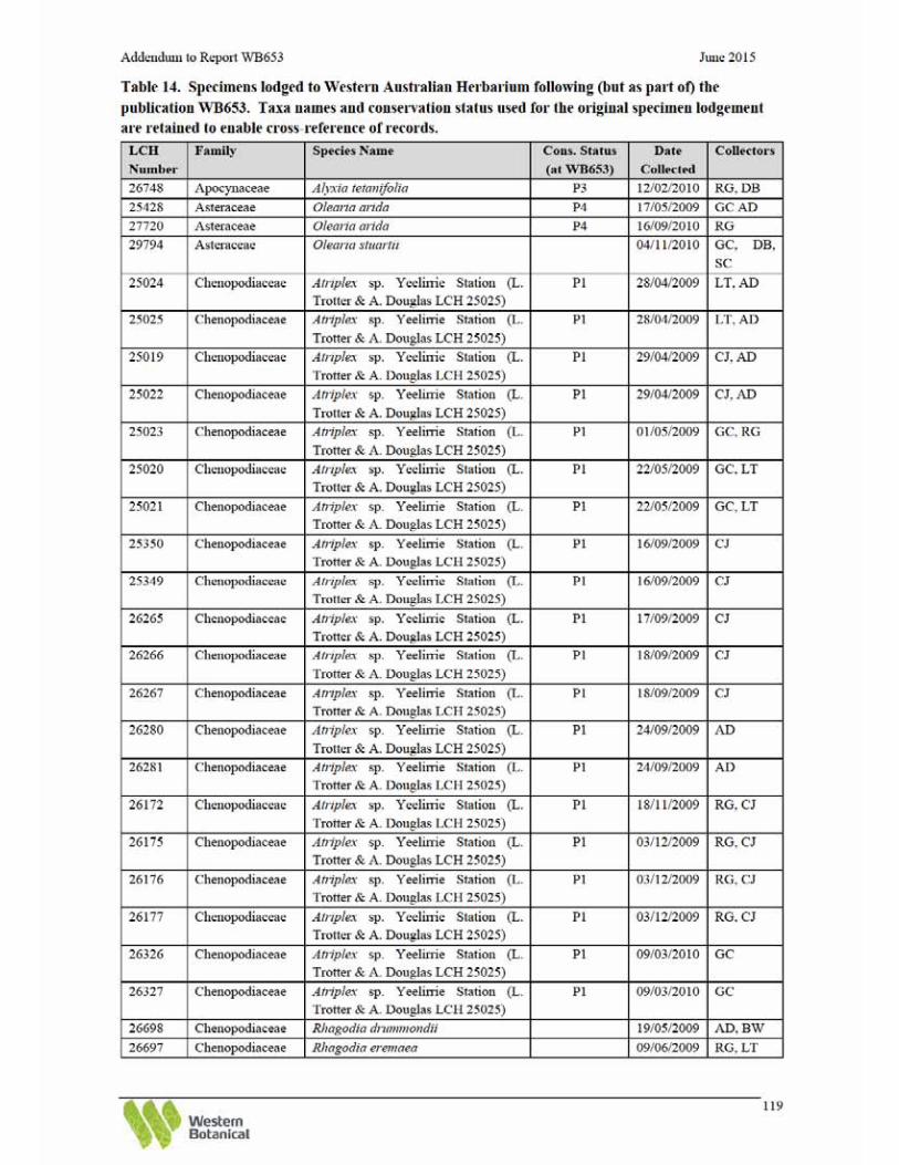


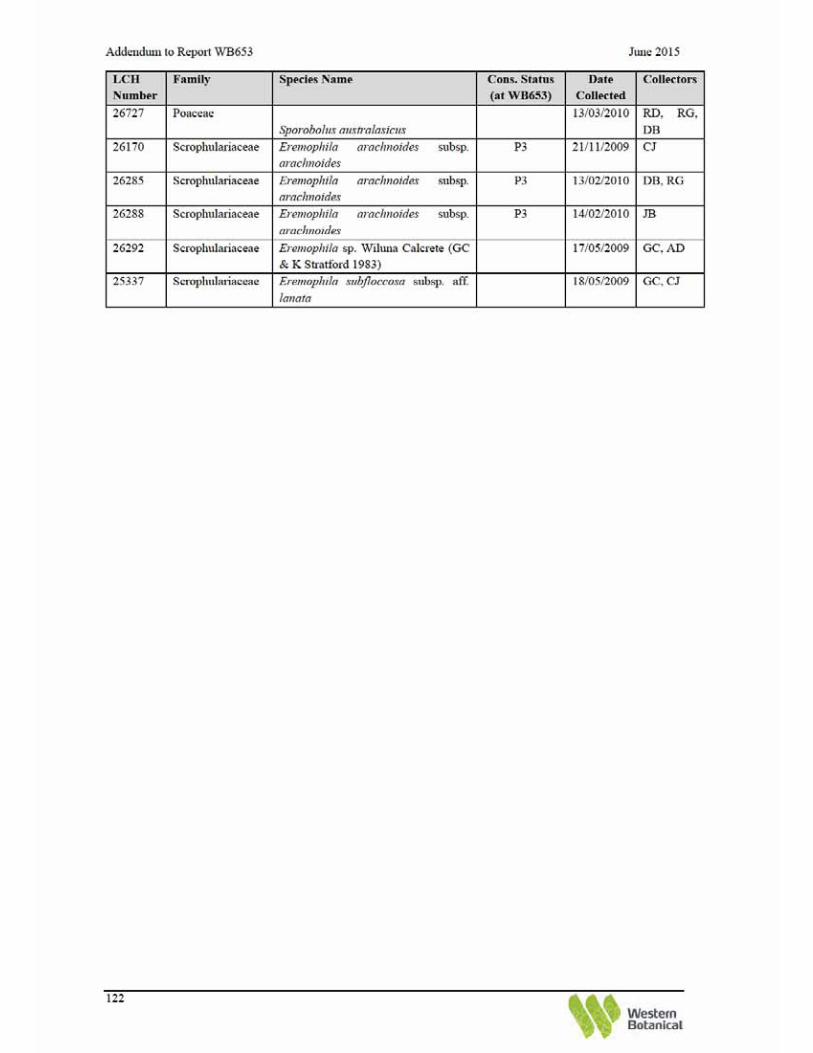

Addendum to Report WB653 June 2015
124
Appendix 2. Revised local species list (Study Areas 1, 2, & 3).


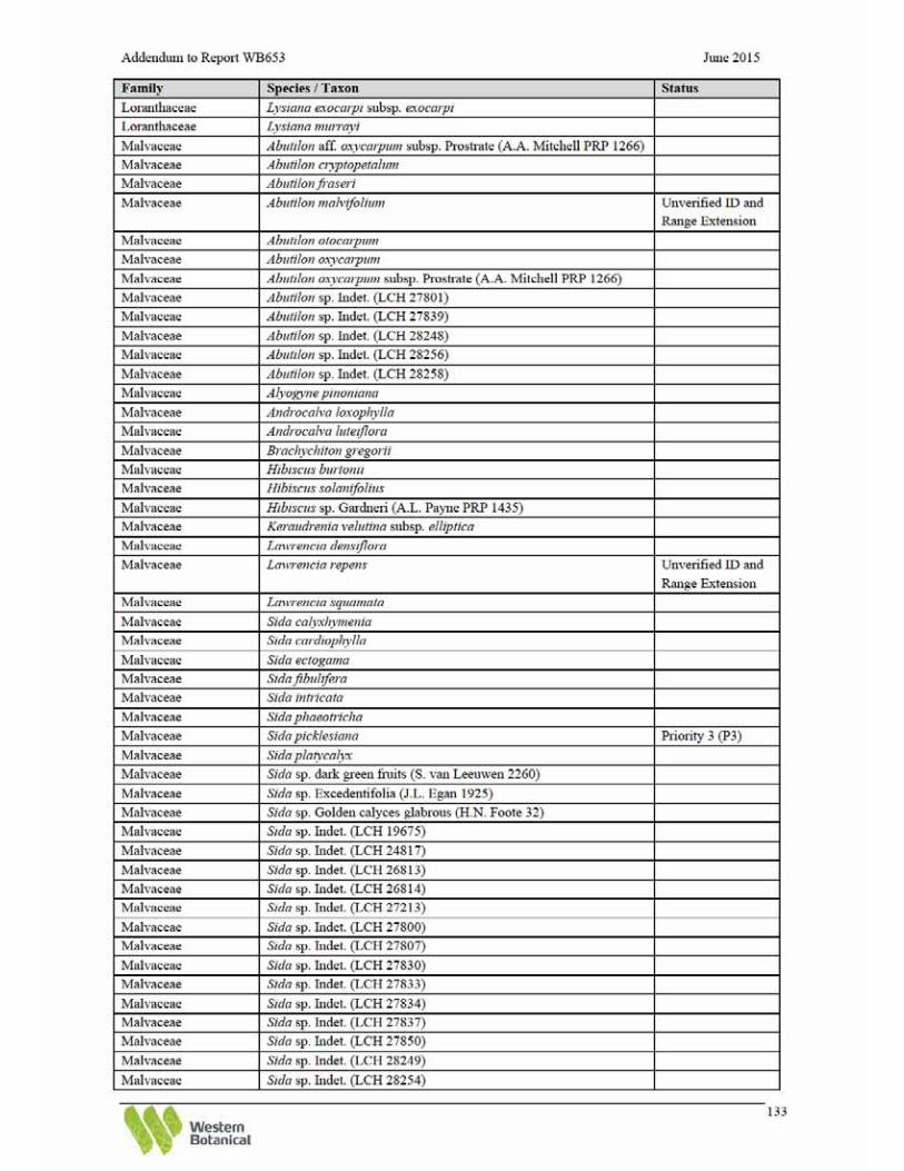


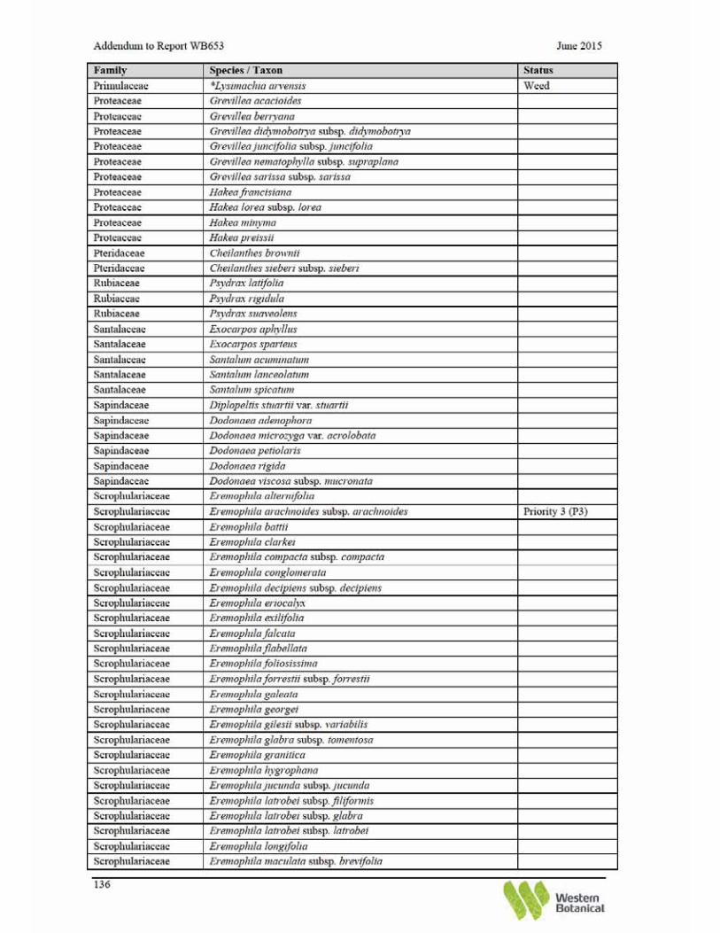


Addendum to Report WB653 June 2015
138
Appendix 3. Revised regional species list (Study Areas 4 - 16).


Addendum to Report WB653 June 2015
142
Appendix 4. Summary of DPaW Threatened and Priority Flora Database Search
Search reference 16-0215.
Table 16: Summary of Threatened and Priority flora identified by DPaW searches.
Table 17: Coordinates of known Threatened and Priority flora populations (DPaW search results only).


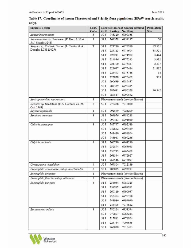


Addendum to Report WB653 June 2015
148
Appendix 5. Keighery Vegetation Condition Scale
From Government of Western Australia 2000
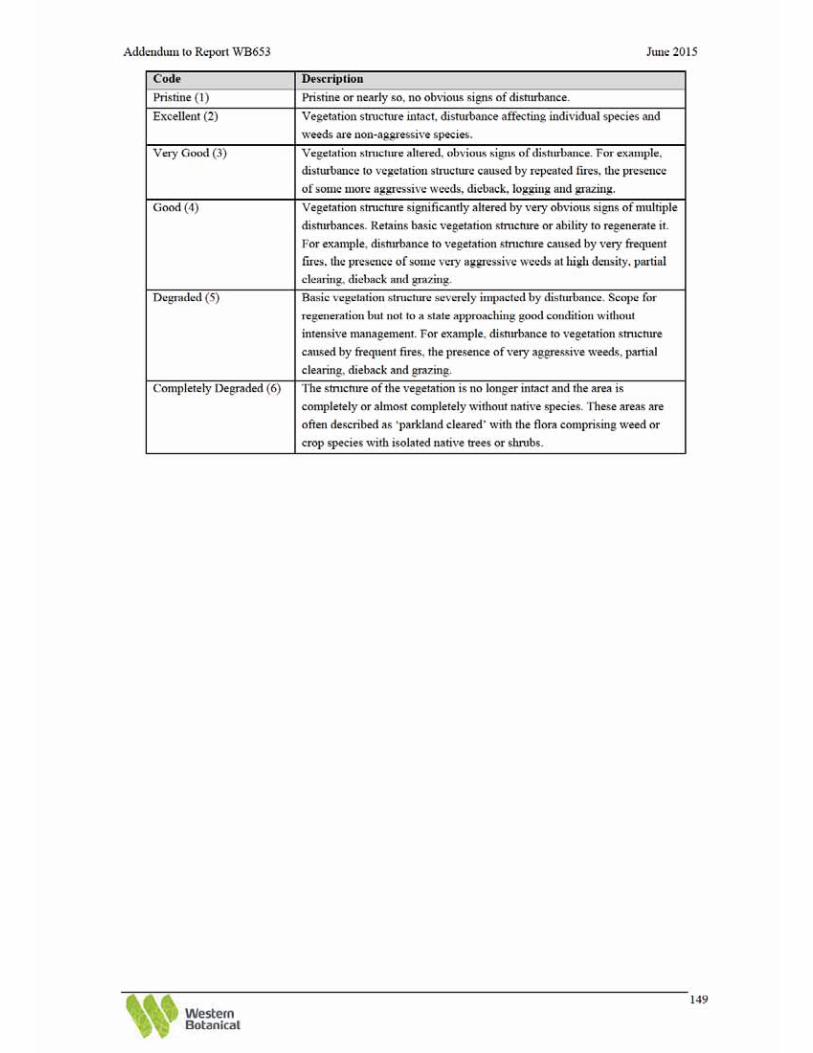

Addendum to Report WB653 June 2015
150
Appendix 6. Corrected quadrat and releve summaries of WB653.

Addendum to Report WB653 June 2015
151
BHP Billiton Yeelirrie Site R009 Described by Geoff Cockerton Date: 25/04/2009 Type: Releve Season: Poor
Location: Yeelirrie study area 1
MGA Zone: 51J 214142 mE 6977819 mN Vegetation Code: SAMU Landscape Association: Sand Plain System Fire Age: Long unburnt
Species List: Name Acacia ayersiana Acacia ramulosa var. linophylla Acacia tetragonophylla Amyema hilliana Eremophila latrobei subsp. latrobei Grevillea berryana Grevillea sarissa subsp. sarissa Melaleuca interioris Santalum lanceolatum Senna artemisioides subsp. filifolia Spartothamnella teucriiflora Triodia basedowii BHP Billiton Yeelirrie Site R010 Described by Geoff Cockerton Date: 25/04/2009 Type: Releve Season: Poor
Location: Yeelirrie study area 1
MGA Zone: 51J 215190 mE 6977163 mN Vegetation Code: SAMU Landscape Association: Sand Plain System Fire Age: Long unburnt
Species List: Name Acacia ayersiana Acacia ramulosa var. linophylla Triodia basedowii

Addendum to Report WB653 June 2015
152
BHP Billiton Yeelirrie Site R011 Described by Geoff Cockerton Date: 25/04/2009 Type: Releve Season: Poor
Location: Yeelirrie study area 1
MGA Zone: 51J 215191 mE 6977008 mN Vegetation Code: SAMU Landscape Association: Sand Plain System Fire Age: 10 years
Species List: Name Acacia ayersiana Acacia colletioides Duboisia hopwoodii Grevillea berryana Marsdenia australis Santalum lanceolatum Scaevola spinescens terete leaf form (G Cockerton & C Ringrose 14560) Senna artemisioides subsp. filifolia Triodia basedowii BHP Billiton Yeelirrie Site R012 Described by Geoff Cockerton Date: 25/04/2009 Type: Releve Season: Poor
Location: Yeelirrie study area 1
MGA Zone: 51J 215210 mE 6976442 mN Vegetation Code: SAMU Landscape Association: Sand Plain System Fire Age: Long unburnt
Species List: Name Acacia ayersiana Acacia pachyacra Acacia prainii Alyogyne pinoniana Dicrastylis sessilifolia Eremophila glabra subsp. tomentosa Eucalyptus trivalva Keraudrenia velutina subsp. velutina Leptosema chambersii Scaevola spinescens terete leaf form (G Cockerton & C Ringrose 14560) Senna artemisioides subsp. filifolia Solanum lasiophyllum Triodia basedowii
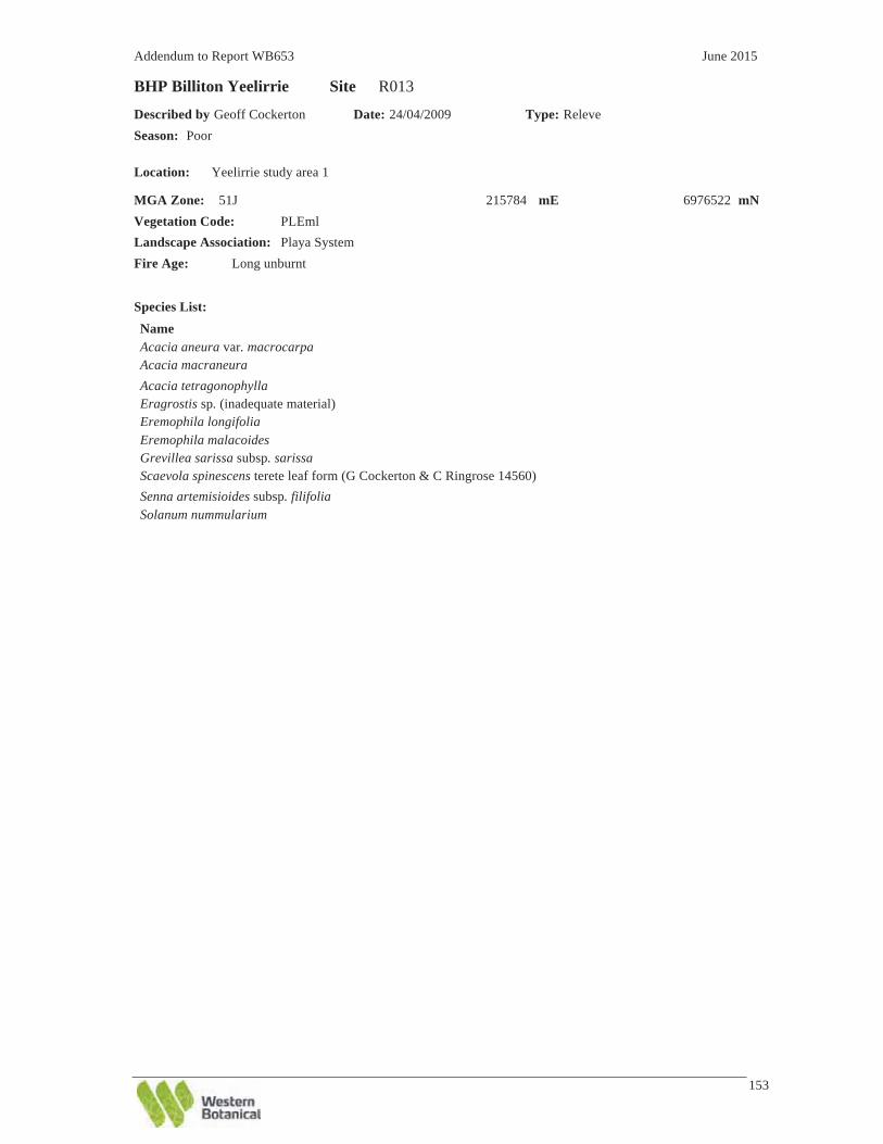
Addendum to Report WB653 June 2015
153
BHP Billiton Yeelirrie Site R013 Described by Geoff Cockerton Date: 24/04/2009 Type: Releve Season: Poor
Location: Yeelirrie study area 1
MGA Zone: 51J 215784 mE 6976522 mN Vegetation Code: PLEml Landscape Association: Playa System Fire Age: Long unburnt
Species List: Name Acacia aneura var. macrocarpa Acacia macraneura Acacia tetragonophylla Eragrostis sp. (inadequate material) Eremophila longifolia Eremophila malacoides Grevillea sarissa subsp. sarissa Scaevola spinescens terete leaf form (G Cockerton & C Ringrose 14560) Senna artemisioides subsp. filifolia Solanum nummularium