Adaptation to Climate Trends: Lessons From the Argentine ... to Climate Trends_ Lessons... ·...
42
Adaptation to Climate Trends: Lessons From the Argentine Experience Vicente Barros, University of Buenos Aires AIACC Working Paper No. 38 September 2006 Direct correspondence to: Vicente Barros, [email protected] An electronic publication of the AIACC project available at www.aiaccproject.org .
Transcript of Adaptation to Climate Trends: Lessons From the Argentine ... to Climate Trends_ Lessons... ·...

Adaptation to Climate Trends: Lessons
From the Argentine Experience
Vicente Barros, University of Buenos Aires
AIACC Working Paper No. 38 September 2006
Direct correspondence to: Vicente Barros, [email protected]
An electronic publication of the AIACC project available at www.aiaccproject.org.
AIACC Working Papers
Distributed by: The AIACC Project Office
International START Secretariat 2000 Florida Avenue, NW
Washington, DC 20009 USA www.aiaccproject.org
AIACC Working Papers, published on-line by Assessments of Impacts and Adaptations to Climate Change (AIACC), is a series of papers and paper abstracts written by researchers participating in the AIACC project. Papers published in AIACC Working Papers have been peer reviewed and accepted for publication in the on-line series as being (i) fundamentally sound in their methods and implementation, (ii) informative about the methods and/or findings of new research, and (iii) clearly written for a broad, multi-disciplinary audience. The purpose of the series is to circulate results and descriptions of methodologies from the AIACC project and elicit feedback to the authors. The AIACC project is funded by the Global Environment Facility, the Canadian International Development Agency, the U.S. Agency for International Development, and the U.S. Environmental Protection Agency. The project is co-executed on behalf of the United Nations Environment Programme by the global change SysTem for Analysis Research and Training (START) and The Academy of Sciences for the Developing World (TWAS). Assessments of Impacts and Adaptations to Climate Change (AIACC) seeks to enhance capabilities in developing countries for responding to climate change by building scientific and technical capacity, advancing scientific knowledge, and linking scientific and policy communities. These activities are supporting the work of the United Nations Framework Convention on Climate Change (UNFCCC) by adding to the knowledge and expertise that are needed for national communications of parties to the convention and for developing adaptation plans. AIACC supports 24 regional assessments in Africa, Asia, Latin America and small island states in the Caribbean, Indian and Pacific Oceans with funding, mentoring, training and technical assistance. More than 340 scientists, experts and students from 150 institutions in 50 developing countries and 12 developed countries participate in the project. For more information about the AIACC project, and to obtain copies of other papers published in AIACC Working Papers, please visit our website at www.aiaccproject.org.
1
Adaptation to Climate Trends: Lessons From the Argentine Experience1
Vicente Barros, University of Buenos Aires
1. Introduction The most severe impacts of climate change are likely to occur in the future, several
decades from now. Knowledge about the impacts is ambiguous because of the
uncertainty of future climate evolution, especially at regional and local scales. Thus, even
in well-organized societies, adaptation to future climate is generally not a priority, except
when there is certainty about the direction of the future trends, as in the case of sea level
rise. In developing countries, adaptation is, in addition, hindered by the lack of social and
institutional practices of long-range planning.
Societies are not always completely adapted to the present climate, as most of the present
climate variability and of its socioeconomic impacts are neither fully identified nor
completely understood. Therefore, there is a large margin for adaptation to better manage
present climate variability. This has stimulated research on adaptation to climate
variability, mostly at the interannual scale, as a way to draw lessons for adaptation to
climate change.
1 The research reported in this paper was supported by grant number LA26 from Assessments of Impacts and Adaptations to Climate Change (AIACC), a project that is funded by the Global Environment Facility, the Canadian International Development Agency, the U.S. Agency for International Development, and the U.S. Environmental Protection Agency and co-executed on behalf of the United Nations Environment Programme and by the Global Change SysTem for Analysis, Research and Training and The Academy of Sciences for the Developing World. Correspondence regarding this paper should be directed to Vicente Barros, [email protected].

2
Less attention has been directed to long-term trends (20 to 50 years long) that have
substantially altered the climate in some areas of the world. These trends, whether related
to global climate change or not, produce socio-economic impacts and adaptation
responses whose study may give some insight on the climate change adaptation process.
Since such trends imply new climate conditions, adaptation to them is perhaps a more
complex process than adaptation to interannual variability. In some cases, as discussed in
this chapter, it takes decades before the appearance of public or even technical awareness
of these trends, and their associated costs or opportunities, while in other cases, responses
are rather fast.
Long-term climate trends are also complicated processes from the physical point of view,
as they may be caused by global warming or by interdecadal natural variability, and in
some cases by both. The attribution of a regional trend to global warming, when
scientifically sound, has many advantages. First, it makes more predictable its future
evolution, which can help the adaptation process. It also makes the Climate Change issue
more important for the regional society, increasing the chances that regional governments
would contribute to, or demand the acceleration of, the global mitigation process.
However, attribution of regional trends is a complex issue because in addition to global
warming, many natural and locally human-driven processes may contribute to them.
Over most of southern South America, there were important long-term precipitation
trends during the second part of the last century (Barros et al., 2000), and as a
consequence of them, in the mean river streamflows (Camilloni. and Barros, 2003).

3
These trends were positive in the east of the continent and negative on the Andes
Cordillera and west of it (Giorgi, 2003). As a result, there are a number of regions and
socio-economic systems in southern South America that are presently under new climate
conditions. Therefore, the region is paradigmatic of present and recent experiences on
aspects of adaptation to climate change. This chapter analyzes some of these experiences,
namely five, as they give some insight on responses to climate change. They are the rapid
adaptation of the agriculture system, the increasing frequency of floods along the flood
valleys of the great rivers of eastern Argentina (Camilloni. and Barros, 2003; Barros et
al., 2004), the increasing frequency of extreme precipitation events in the central and
eastern part of that country (Re et al., 2006) , the decreasing trend in the discharges of the
rivers fed by the melting of snow and ice over the Andes Mountains and in rainfall in
Central Chile, and the recurrent floods on the coastal zones of the Rio de la Plata caused
by wind storms (Barros et al., 2003). These five case studies cover different climate
aspects, socio economic systems, and responses to the new climate conditions or climate
threats. However, all of them indicate that awareness of climate changes play a central
role in the adaptation process. In addition, they show that scientific knowledge, as a
promoter in some cases of awareness and a guide to appropriate responses is needed for
early and successful adaptation.
As global warming proceeds, it is very likely that many important climate trends will
become evident in other regions of the world. In the meantime, the Argentine experience
can be seen as a laboratory where some of the cultural, social, and institutional responses
to climate change can be studied. Hence, even though this chapter deals with only a

4
region during a specific period, it is more oriented to the theory of adaptation than with
specific policies and measures for the described problems.
The second section discusses the observed long-term trends over Argentina and
neighboring countries from the point of view of the adaptation processes or the lack of
them. Section 3 addresses two examples of lack of awareness that resulted in part from
certain features that helped to mask the climate trends. Finally, the example the recurrent
floods on the coastal zones of the Rio de la Plata caused by wind storms is discussed, as
well as the social trends that may weaken current adaptation. Conclusions are
summarized in section 5.
2. Autonomous and Planned Adaptation Responses to Current Long-Term Trends
Adaptation to climate changes could be anticipatory or simply reactive after changes have
taken place. Anticipatory adaptation takes place before impacts of climate change are
observed, also referred to as proactive adaptation (IPCC, 2001). This adaptation is
necessarily based upon scientific knowledge that anticipates how changes in climate will
evolve. Adaptation can be undertaken in a planned mode, usually under collective and
organized social policies or measures, more likely directed by an agency at some
governmental level or by a large public or private organization. Planned adaptation may
come either before or after the changes.

5
The adaptation that does not constitute a conscious response to climate stimuli but is
triggered by climate driven changes in natural or human systems is called autonomous
adaptation (IPCC, 2001). Usually, autonomous adaptation is the result of decisions by
individuals or groups acting independently but that nonetheless could have large
cumulative effects and which, because of their nature, are more likely to be reactive
responses to current climate impacts than preventive measures.
2.1 A case of autonomous adaptation: the expansion of the agriculture frontier
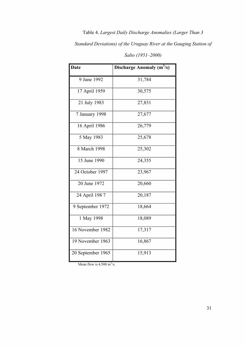
Southern South America, east of the Andes Cordillera, is one of the regions of the world
that has shown the largest positive trend in mean annual precipitation during the 20th
century (Giorgi, 2003). Until the 1960s, these trends, although positive, were rather small
and even negative in some areas, but after 1960, these precipitation trends became
considerably positive (Fig. 1).
Until recently, there was only modest technical knowledge of the long-term climate
trends (Castañeda and Barrros, 1994; Barros et al., 2000) and no public awareness of
them. Thus, the adaptation responses were only reactive and autonomous and limited to
sectors where changes were more easily perceived and managed. Therefore, the rapid
adaptation to the new climate conditions aided by new technologies resulted in the
expansion of the agriculture toward the west of what was known as the humid plains.
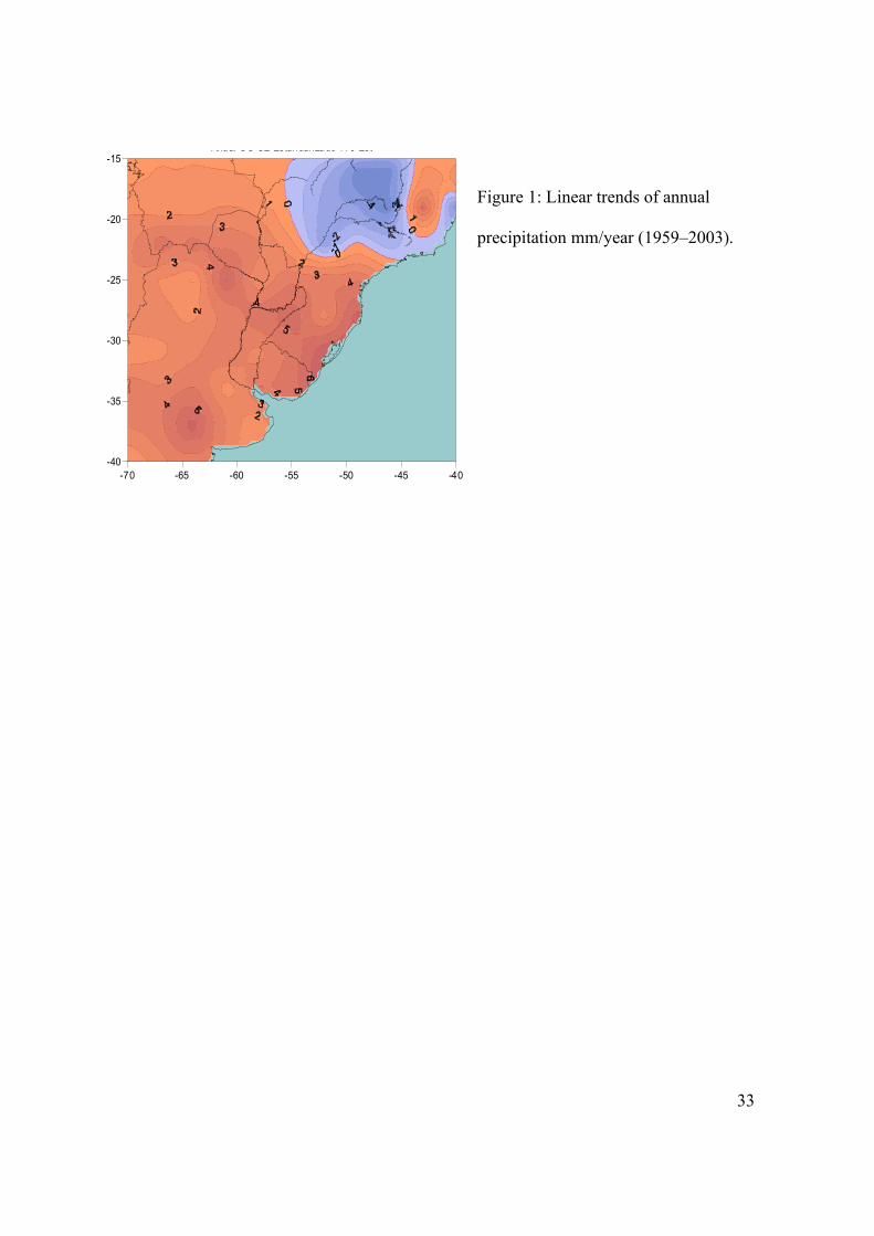
Figure 2 shows a 100-km westward shift of the isohyets that are considered the boundary

6
of extensive agriculture, namely 600 mm annual rainfall in the south and the 800 mm in
the north.
Autonomous adaptation proved to be fast in the agricultural sector of Argentina and
rather effective in terms of immediate economic benefits. Until 1992, the cultivated lands
occupied about 20 million hectares. Since then, this area has expanded each year,
reaching 29 million hectares in 2004; 4.6 million, out of the new 8.7 million hectares
were located in the provinces of La Pampa, Córdoba, Santiago del Estero, and Chaco,
that is, in the western and northwestern border of the traditional humid plains. Part of the
territory of the first two provinces was already in the humid area before 1960. Table 1
shows the cultivated areas for these four provinces.
Since 1982/1983, there were not major changes in the case of La Pampa, while in the
other three provinces where the climate permits soybean farming there was a steady
positive trend in cultivated area. The expansion of the soybean was driven by
international prices and new technological packages that included minimum or nontilling
practices. However, its geographical extension to former semiarid regions was possible
because of the positive trend in precipitation that took place between the second half of
the 1970s and the 1990s.
In the south of subtropical Argentina, in the provinces of Buenos Aires, La Pampa, and
Cordoba, the positive trend in precipitation started earlier, in the 1960s (Barros et al.,
2000). At that time, the agriculture expansion was an expansion in the cultivation of
7
crops other than soybean. There was an important extension in the cultivated area in
provinces of La Pampa and Cordoba during the 1970s, as well as in the Buenos Aires
province that jumped from 8.3 to 9.6 million hectares from 1971/1972 to 1982/1983. In
addition to the geographic extension of the agriculture, larger yields in the lands
traditionally devoted to agriculture can be also partially attributed to the positive
precipitation trends (Magrin et al., 2006).
This adaptation was autonomous and not planned by the government or by any other
organization. It resulted from a large number of individual decisions that were taken even
before the technical specialists realized that new climate conditions allowed successful
crops in lands that were earlier considered to have no potential for crop farming. This
adaptation or adjustment followed the climate trends with a lag time of about one decade,
when the farmers realized that the new climate conditions were persistent.
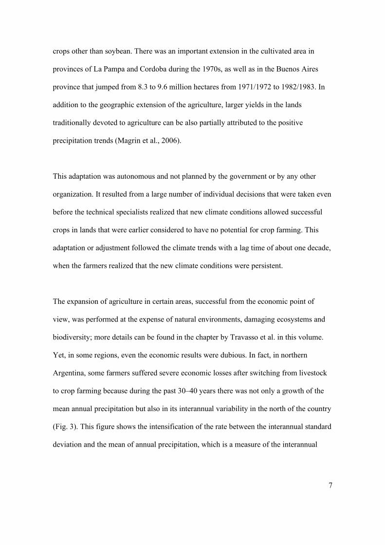
The expansion of agriculture in certain areas, successful from the economic point of
view, was performed at the expense of natural environments, damaging ecosystems and
biodiversity; more details can be found in the chapter by Travasso et al. in this volume.
Yet, in some regions, even the economic results were dubious. In fact, in northern
Argentina, some farmers suffered severe economic losses after switching from livestock
to crop farming because during the past 30–40 years there was not only a growth of the
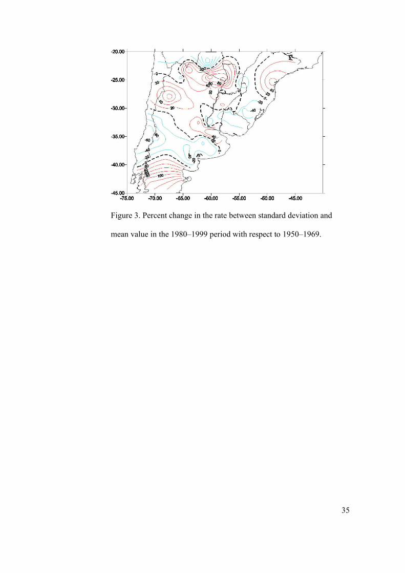
mean annual precipitation but also in its interannual variability in the north of the country
(Fig. 3). This figure shows the intensification of the rate between the interannual standard
deviation and the mean of annual precipitation, which is a measure of the interannual
8
variability. This change increased the vulnerability of farming to climate, especially in
the case of modern agriculture where the costs of inputs are considerable. While the rise
in the mean annual precipitation was rapidly noticed by farmers, the increasing
interannual variability was not always perceived, leading in some cases to severe losses.
Deforestation to convert the land to crop farming use is causing losses in ecosystems and
biodiversity in the north of the country. Even if the recent precipitation trend were caused
by global warming, it could be reversed in the future, since its relation to global
temperature would not necessarily be linear. In such a case, the loss of the natural
vegetation cover will favor a desertification process. These considerations led the
government to issue a moratoria forbidding further deforestation in the province of
Santiago del Estero. Some of the undesirable consequences of the rapid adaptation of the
Argentine agricultural sector indicate that autonomous adaptation to climate change is a
process that requires more attention and research. Technical advice to moderate its
negative impacts can help in the adoption of better choices, both from the environmental
and the economic point of view.
In the Argentine Pampas, there are large areas of plains with very small slopes where
water runoff is very slow. In these areas, the positive trend in precipitation was
accompanied by a greater frequency and extension of floods. While autonomous
adaptation by individuals was rapid, public initiatives were absent for decades, and only
recently were some works undertaken to facilitate and manage the water runoff.
Meantime, a chaotic network of unauthorized private channels has been developed. Many
9
landowners try to drain the water from their fields toward their neighbors, creating
numerous conflicts. In addition, roads do not have adequate drainage conditions and act
as dams. Taking or not taking corrective measures is another source of conflict. The
lesson from these situations is that adaptation in the form of anticipatory and inexpensive
regulation, as well as their enforcement, is not only convenient but highly recommended
because they are rather difficult to impose after the impacts of climate change have
occurred.
Another indication of the lack of solutions to address the new climatic and agricultural
conditions coming from the public sector is the lack of an appropriate network of rural
roads in areas where agriculture is now expanding. Table 2 shows the small density of
rural roads in the meridional axis of the expansion of the agriculture frontier that goes
from La Pampa in the south, through Cordoba to Santiago del Estero and Chaco in the
north. This lack of roads is deterring further expansion of the agriculture in those
provinces.
2.2 A case of planed adaptation: the great rivers floods
Consistent with precipitation trends, streamflows and flood frequency of the great rivers
of the Plata basin, namely the Paraná, Paraguay, and Uruguay rivers, have considerably
increased since the middle of the 1970s (García and Vargas, 1998; Genta et al., 1998;
Barros et al., 2004). The percent amplification of their streamflows was two to three
times greater than those of precipitation over their respective basins. Since
10
simultaneously, there was an important land use change, this amplification was attributed
in some cases to this process. However, Berbery and Barros (2002) have shown that this
amplification rate was basically explained by the features of the basin and that
streamflow trends were to a large extent due to the precipitation trend. This was also
shown with various examples of sub-basins by Tucci (2003), who estimated that at least
two-thirds of the trends in the streamflows of the Plata basin were caused by the
precipitation trends. This large amplification of the streamflow response to changes in
precipitation implies that activities based on or affected by these streamflows are highly
vulnerable to climate variability and to climate change.
Until now, power generation was greatly favored by the regional climate trend, while the
negative consequences were the increased frequency of great floods that caused huge
social and economic damages. Although the large streamflows originate in the Brazilian
and Paraguayan territories, the greatest floods occur in Argentina along the coasts of the
Paraná. In 1998, the flooded area reached 45,000 km2, and similar areas were affected by
comparable floods in 1992 and 1983.
There are clear indications of a change in the frequency of these floods; four out of the
five greatest discharges of the 20th century of the major river of the Plata Basin, the
Paraná River, occurred in the past 20 years (Table 3). A similar situation occurred with
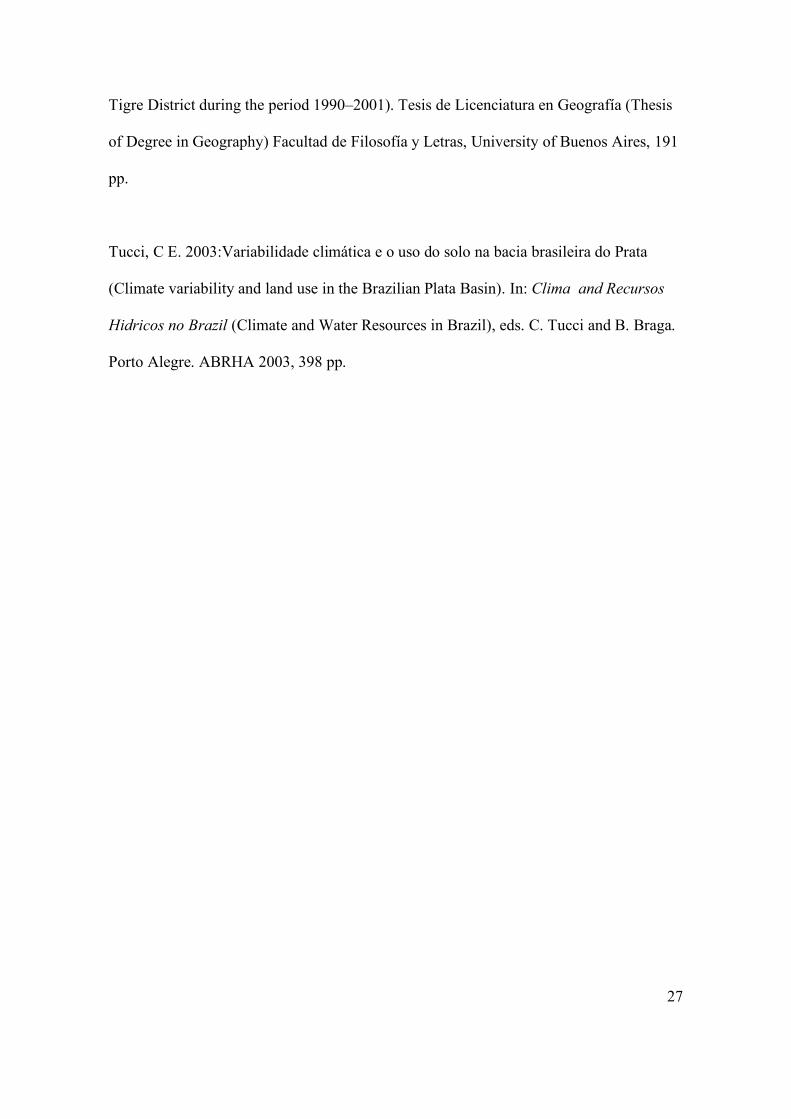
the Uruguay River (Table 4), whose floods extended over less territory with smaller
socio-economic impacts than in the case of the Paraná. It can be seen that during the

11
second part of the last century, there was an increase in frequency of large discharges,
one in the 1950s, two in the 1960s and 1970s, five in the 1980s, and six in the 1990s.
A study made for the World Bank indicates that Argentina ranks 14th among the
countries affected by floods with economic losses that sometimes reach more than the 1%
of the annual GNP. The magnitude of the area flooded by the great rivers and the number
of people damaged helped to create a rapid awareness of the change and the need to cope
with it. Since the worst flood events were related to El Niño (Table 2), there was a
general public belief that this was a new phenomenon. This was only partially wrong,
because the perception of the change was correct, and it was this public awareness that
created the conditions for government action. The connection with El Niño events helped
to identify a known cause, and it was in line with the international perception facilitating
the help of the international credit (Table 4). As a result, a public adaptation policy was
implemented after the great flood of the great tributaries of the Plata River in 1983 and its
reiteration in 1992. After the 1983 flood, a hydrologic alert system was implemented with
a focus on the floods of the great rivers of the Plata Basin. This system was improved
after the 1992 flood, and several programs of reconstruction and structural measures
(defenses) were executed with credits of international banks (Table 4).
Although streamflow and flood duration were different in each case, the flooded areas in
1983 and 1998 were about the same. However, because of the defenses built, the number
of people evacuated was considerably less in 1998, about 100,000 versus 234,000 in
1983. Unfortunately, this is the only overall objective measure of the successful, although
12
yet incomplete, adaptation, aside from the direct qualitative assessment made
immediately after the 1998 flood. In fact, a national assessment of economic losses of the
1998 flood, comparable to the one made for the 1983 flood, is still lacking. Yet, it can be
said that the preventive actions constituted a partial and successful adaptation.
What this case shares in common with the preceding example was awareness. This was
favored by the fact that in both cases the changes were perceived by the key sectors. In
the first case, farmers´ reactions came sooner than the government's, a reaction that is still
incomplete and in many cases delayed. On the other hand, in the case of the great river
floods, the change was easily perceived by the whole society, and this awareness led to
prompt public action.
3. Masked climate trends
It seems obvious that the first requirement for adaptation to climate change or climate
trends is awareness and perception of their associated advantages or threats. However
what is not obvious is if and how affected sectors become aware of certain climate trends.
There are a host of reasons for this to happen, ranging from the features of the change, to
the complex nature of the relationship of the key sectors with the resources affected. In
this section, only two of these reasons, which are related more to natural features of the
change than to social aspects, namely slow but very long trends and changes in extreme
but infrequent events, will be addressed.
3.1 Slow trends
13
Climate trends can be slow enough to pass unperceived or masked by interannual or
interdecadal climate variability. What happened in western Argentina and central Chile is
an example of this assertion.
The west of Argentina is mostly covered by arid lands. In the case of the region of Cuyo
(between 27° and 38° S), near the Andes Mountains, annual precipitation is about 100
mm, and population and economic life are concentrated on the river oasis. The rivers are
basically fed by snow melting in the mountains and therefore have a pronounced annual
cycle with a maximum in summer. In the Comahue region (between 36° and 42° S),
annual precipitation is still very small, less than 200 mm in the plain, but considerably
greater over the Andes. Thus, in the plains, as in Cuyo, population and economic
activities depend on rivers, although they result from snow melt and rainfall as well.
In both regions, there is a long-term decreasing trend in the river flows. For different
reasons, in Cuyo and Comahue, the potential dangers of this trend do not seem to be
noticed by the public or the key sectors involved with the water administration.
One common problem in the two regions is the lack of enough monitoring of
precipitation on the Andes where there are not long series of snowfall data. Therefore,
precipitation trends over the Andes only can be indirectly assessed. Because the same
synoptic systems that precipitate in Chile produce snowfall over the Andes Mountains,
precipitation trends in Central Chile can be seen as indicators of trends over the Andes.
Figure 4 shows annual precipitation for two stations that are at the extremes of the

14
latitudes between which Cuyo and Comahue are located. Both stations show definite
downward trends that are also present in all the other stations (not shown) at intermediate
latitudes. In addition, most of the climate models, with some differences in intensity,
show that this downward trend will continue during the present century. The agreement
in the direction of climate changes from different socio-economic scenarios and models
means that this signal is robust and very likely to actually occur.
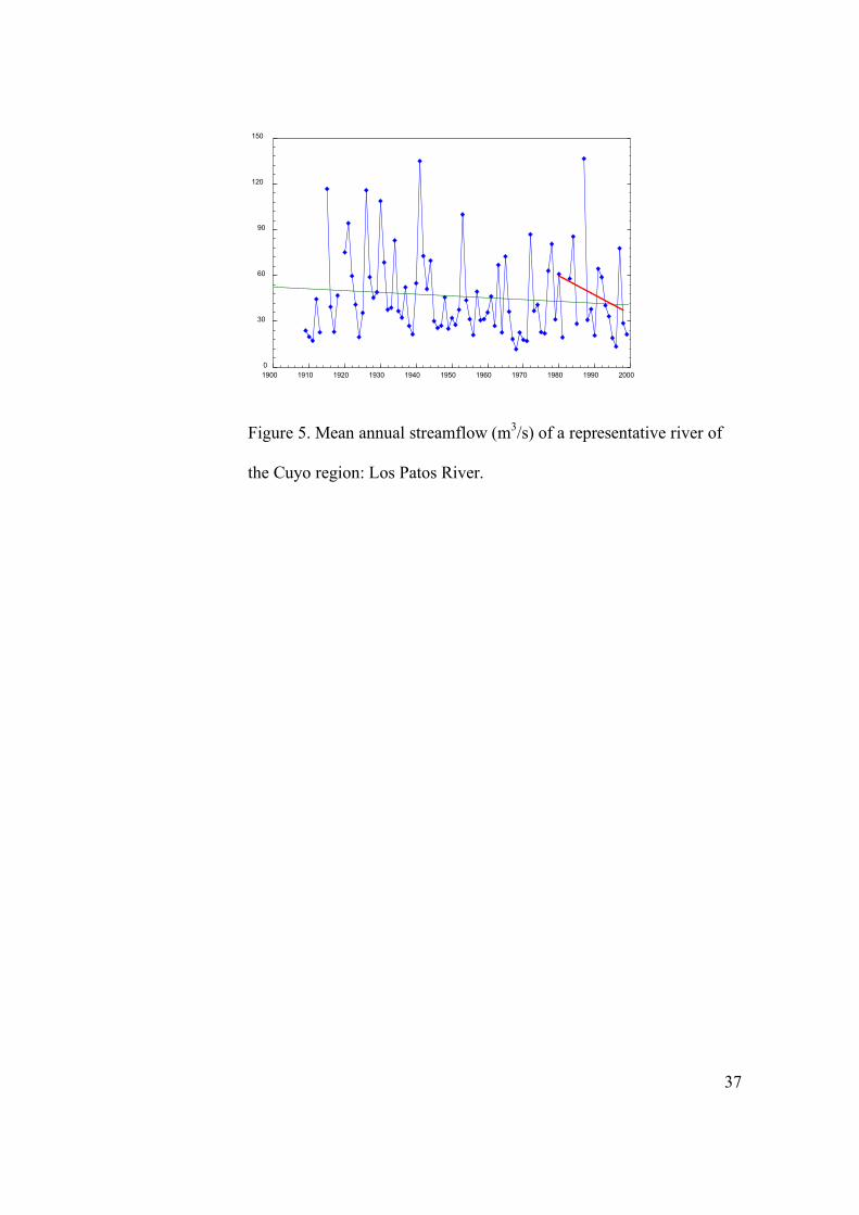
Consistent with precipitation trends in Chile, rivers in Cuyo and Comahue have a general
downward trend that is illustrated by two examples in Figs. 5 and 6. In the case of Cuyo,
there were two downward trends during 1920–1938 and 1945–1970, followed by periods
of recovery (Fig. 5). During the second negative trend, there was a widespread public
concern about the future viability of the oasis economy that led to a better administration
of water.
In view of the recovery of the 1970s, the key sectors became skeptical concerning the
dangerous implications of this long-term trend, especially with the new downward trend
that started in the mid-1980s (Fig. 5). Thus, the public memory of interannual and
interdecadal variability that is masking the secular trend contributes to the lack of risk
perception of the unfavorable long-term trend.
This little concern is the cause and also partially the consequence of the lack of
systematic monitoring of snow in the mountains and of the evolution of the glaciers.
Indeed, the little documentation available indicates a general receding of glaciers. If this
15
were the case, it would be an indication of a decline in the water stock in the mountains,
which together with the downward trend of the rivers and in the precipitation should be a
matter of great concern, especially in view that future trends would continue in the same
direction.
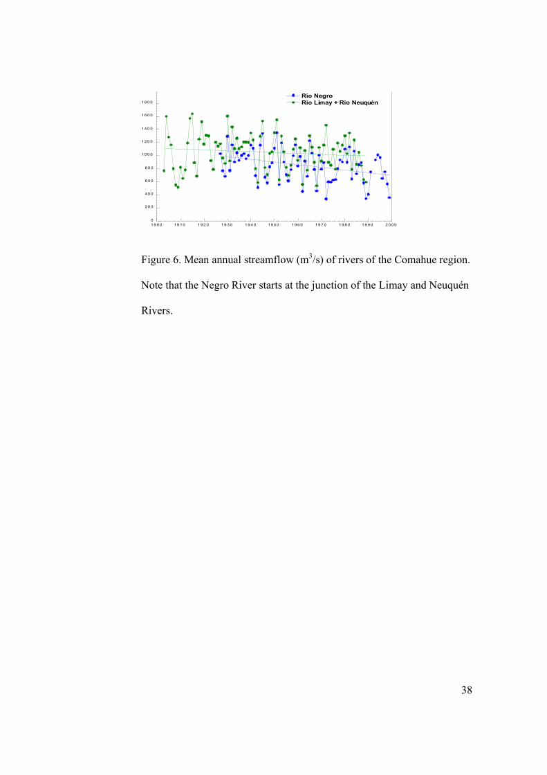
In the case of Comahue, the downward trend was ignored until recently when technical
specialists began to analyze climate change data. This region possesses 25% of the
installed hydroelectric power in the country, providing 15% of the country's generated
power, all of which is from hydroelectric dams. Since the dams were designed to produce
energy at peak hours, they are designed to produce more than what corresponds to the
average flow. Thus, with the same investment, if they were run with the 1940 flows, they
would produce 30% more energy than they do now (J. Devoto, personal
communication).The other major use of water is farming, but since only a small fraction
of it is used, no shortage has been felt yet.
Cuyo differs from Comahue in that it has a long-established population, whereas
Comahue has been populated in relatively recent times and most of their population are
immigrants from other provinces or countries. Thus, there is a weak collective memory
about the natural conditions and hazards, which could why the general public is unaware
of the trends in the river flows. This aspect, the new population, will be treated in other
geographical context in section 4.
16
Central Chile is the more developed and populated region of that country. The lack of
rainfall during summer makes necessary irrigation for most crops. In addition, power
generation is greatly produced from hydropower. Therefore, Chile heavily depends on its
water resources. However, the slow but persistent downward trend of precipitation during
the past century (Fig. 4) and its projected furtherance during the present century as
predicted by almost all climate scenarios, has deserved little public and scientific
attention in that country.
It can be concluded that slow but steady trends, which could be related to climate change
and are likely to continue according to climate change scenarios, can be masked by the
interannual and decadal variability that mislead the population and the key sectors,
preventing awareness about the long-term trend.
3.2 Changes in the frequency of extreme events
Changes in extreme, but infrequent, events can take time before they are perceived by the
public. Although extreme events cause severe damages and losses, including lives on
certain occasions, the more extreme of them are generally infrequent, occurring once in
many years. Thus, even a considerable increase of these events may not be perceived
until a catastrophic event captures the public attention, as happened in Argentina.
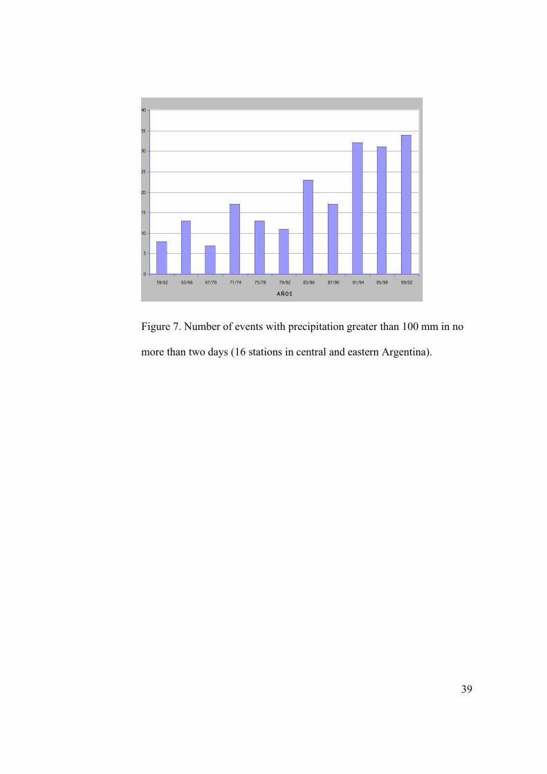
Trends toward a greater frequency of extreme precipitation have been observed in the
central and eastern part of Argentina, as the regional average shows in Fig. 7. It can be
17
seen that the number of events of precipitation greater than 100 mm in no more than two
days started to increase about 1980, and by the end of the century, they were triple the
amount observed in the 1960s and 1970s. These trends are something expected in the
context of increased greenhouse gas concentration, (IPCC, 2003) and were observed in
many other regions of the world.
The signal of these trends is robust and does not depend on the threshold. For instance,
for the 150-mm threshold, Fig. 8 shows the annual frequency of events in the 1983/2002
period and the rate between their annual frequency between the 1983/2002 and the
1959/1978 periods. In the eastern part of the country, this rate is almost everywhere
greater than 1, and in some areas in the northeast, it reaches values greater than 4 or even
7. In the last case, this means that where extreme precipitations could be expected once
every 7 years in the past, they occur now every year.
These events have little impact on the great rivers of eastern Argentina, which are
modulated by precipitation over longer times but produce local devastating floods that
affect both rural and urban environments. Cultural habits and infrastructure developed
during a period with different climate are now a burden under the new climate conditions.
Damages caused by these events are enhanced by the inadequate infrastructure (drainage,
bridges, roads, etc.), which was not designed to afford the new climate conditions.
However, even in recent years, the design of new infrastructure has not considered these
new conditions.

18
The population in the area where the 150-mm precipitation events increased twofold is
2.5 million, while in the area where these events are now four times more frequent is 1
million. This population has only a diffuse and unclear awareness of this change. The
poor population, which are more negatively impacted were perhaps aware of the change
but assumed the burden fatalistically and did not ask for adaptive measurements. This
attitude is rapidly changing, especially after the event of April 2003 that flooded half the
city of Santa Fe and took many lives. The people are now pressing for solutions, and once
they suffer the consequences of an event, do not accept the old argument of public
officials that the event was extraordinary or unexpected but, on the contrary, ask for
preventive measures. Thus, national and provincial governments have started to take
some adaptive measures, including implementing new early-warning systems at the
provincial level (Santa Fe) or enforcing land zoning (Chaco). In addition, the Institute for
Water Research started a program to develop new standards for the design of water
management.
Adaptation in this case was delayed because of the lack of technical knowledge, the lack
of an appropriate dense official network of pluviometers, and the difficulties created by
some officials at the National Weather Service to disseminate meteorological data.
However, it is possible that, even with the correct information, not enough preventive
measures would have been taken. As it happens unfortunately with frequency, only big
disasters draw attention to their causes.
19
No matter what is the reason for the lack of public awareness or slow recognition of
climate trends, the scientific and technical infrastructure may provide the information
required to start adaptation measures when needed and possible. Regarding this aspect,
developing countries suffer the disadvantage of their weak scientific system.
4. Forgetting Adaptation Attitudes
The coasts of the Plata River have nearly 14 million inhabitants, most of whom live in the
metropolitan region that includes Buenos Aires city. When strong winds blow from the
southeast, they drag river waters towards the inner part of the river creating high tides,
especially if they are simultaneous with high astronomic tides. These events are locally
known as sudestadas and cause floods along the low coasts of the Argentine margin.
Because of its shape and other features, the sea level rise resulting from climate change
will propagate in the Plata River. The results of the modeling studies developed in the
Assessments of Impacts and Adaptations to Climate Change (AIACC) Project Global
Climate Change and the Coastal Areas of the Río de La Plata indicate that according to
these higher levels, storm surge floods will become more frequent over the coast of the
metropolitan Buenos Aires.
In the areas with a long tradition of coexistence of the population with floods, such as the
neighborhoods of La Boca and Avellaneda, informal networks among neighbors support
local practices and strategies that include an early warning system, self-help, and
evacuation that aid in anticipation of the arrival of floods and tend to diminish
20
vulnerability to floods. However, in both areas, the increasing number of newcomers is
reducing the collective cultural adaptation to floods.
Structural defenses, while of great importance, may inevitably contribute also to the
abandonment of the cultural habits of adaptations to flooding. After its completion in
1998, the works of coastal defense in the city of Buenos Aires have mitigated
successfully the last floods. However, the defense was designed without considering the
future river level rise, which may reduce its efficiency in the future when the knowledge
of practical flood prevention strategies would be forgotten and even institutional
mechanisms of response to floods dismissed.
Until recently, the areas exposed to frequent floods that were not close to the downtown
city were scarcely occupied. As a result of this adaptation to avoid living in flood-prone
areas, the social impact of future frequent flooding would be small. Hence, the major
impacts of climate change in the coastal zone of the Plata River would come from the
increasing height of extreme storm surges and their greater inland reach, both resulting
primarily from the sea level rise.
On the other hand, beginning in the 1980s and 1990s, a trend was observed in which
people moved out of the metropolitan area in favor of living in gated communities. The
increased demand for private gated towns is making the natural areas near the water
attractive for the upper middle class (Ríos, 2002). Thus, it is very common that many
gated communities are being sited on lands that are frequently flooded, though often
21
elevated by developers to obtain an assumed secure height. Aside from the fact that this
massive modification of the environments affects ecosystems and creates drainage
problems, until now, they were built with the assumption that the height of 4.4 m above
sea level was adequate. However, according to the AIACC Project, this height may not
be safe in the future. Thus, all these changes do not favor adaptation to future River water
levels
The trend toward an increased number of gated communities near the coast, in the
margins of the Paraná or even in the front of the Paraná delta, is likely to increase in the
coming years (Rios, 2002). Similarly, low lands in the valleys of some tributaries of the
Plata River are being occupied by people with low income. Thus, the current trend of
occupying lands with flood risk, by both very poor settlements and gated communities of
upper middle class people, does not favor collective adaptation to present and future
scenarios of recurrent floods.
In this context, the AIACC Project's dissemination of its results (Barros et al., 2005) in
collaboration with a local non-governmental organization, Fundacion Ciudad, was very
opportune, as its results will help governments improve decision making regarding global
climate change adaptation strategies. These results will assist individuals and private
developers to make decisions considering climate change.
22
The recent trends in the relationship of the society with the Plata River and its hazards
indicate that new habits, greater resources, or a large percentage of newcomers may lead
a social group to forget its collective adaptive attitudes to climate hazards. At the same
time, they illustrate the importance of research in helping develop and maintain the
collective awareness of both present and future climate hazards.
5. Discussion and Conclusions
Adaptation responses resulting from current regional trends can provide experience on
the socio-economic responses to future climate change. In that sense, the important trends
in climate that were observed in the past 40 years in Argentina provide a wealth of
experiences that deserve further investigation.
In some sectors like agriculture, autonomous adaptation can be relatively fast, as
happened in Argentina during the past few decades. This adaptation is facilitated by the
relatively short production cycle in agriculture and the independent process of decision
making of farmers, which ease quick, results-oriented experiences and choices. However,
autonomous adaptation sometimes has undesirable implications for the environment,
other sectors, or people, as well as even the self-interests of those who take the adaptive
actions. Therefore, autonomous adaptation requires help from the public and research
sectors to ameliorate its benefits and reduce its negative impacts.
23
When decisions cannot be individually taken, but depend on large entities like
governments or big companies, public awareness is a key issue in the process of
adaptation to climate trends. Of course, this awareness may start in the technical spheres,
but political and economic decisions are more feasible when they are shared by public
opinion, even in those cases when the required funds come from international agencies,
as is sometimes the case in developing countries
Two examples in this chapter showed that, sometimes, climate trends may have features
that make them difficult to be noticed by society. This is more likely to occur when the
local observing system is insufficient to provide the required information. Slow but
steady trends, which could be related to climate change, can be masked by interannual
and especially by interdecadal variability. This variability can confuse the population and
the key sectors, preventing their perception of the risks associated with the long-term
trend. In this chapter, it was shown that a downward trend in precipitation and river
streamflows has been taking place for a century in two regions of Argentina and in
central Chile without much public awareness. Other case reported in this chapter was the
trend to more frequent extreme, but occasional, precipitation in eastern Argentina. It was
only after a big catastrophic event in the city of Santa Fe in April 2003, that the attention
of the public, authorities, and specialists was attracted to this issue.
Changes in social attitudes and habits, new resources like structural defenses or
highways, the large percentage of immigrants, and even new technologies may lead
24
society to forget its collective adaptation attitudes to climate hazards. This process could
become especially negative if these hazards are enhanced by climate change.
The cases shown in this chapter indicate that adaptation to current trends may be delayed
because of the lack of technical knowledge, lack of an appropriate monitoring system,
and difficulties in the dissemination of data and information. Regarding future changes,
the scientific and technical system may provide the information required to start
adaptation when needed and possible. In both cases, the vulnerability of developing
countries is enhanced by their lack of a solid scientific system.
Acknowledgments
The research reported in this chapter was supported by grant number LA 26 from
Assessments of Impacts and Adaptations to Climate Change (AIACC).
References
Barros, V., E. Castañeda, and M. Doyle. 2000. Precipitation trends in Southern South
America, east of the Andes: An indication of climate variability. Southern Hemisphere
In: Paleo-and Neoclimates: Key Sites, Methods, Data, and Models. New York: Springer,
pp. 187–208.
25
Barros, V., L. Chamorro, G. Coronel, and J. Baez. 2004. The major discharge events in
the Paraguay River: Magnitudes, source regions, and climate forcings. J Hydrometeorol.
5:1061-1070.
Barros,V., I. Camilloni, and A. Menéndez 2003: Impact of global change on the coastal
areas of the Rio de la Plata. AIACC Notes. 2:9–12.
Barros, V. A, Menendez, and G. Nagy (Eds.). 2005. ¨El cambio climático en el Río de la
Plata¨ (The Climate Change in the Plata River) Buenos Aires: CIMA, 2005, 200 pp.
Berbery, E., and V. Barros. 2002. The hydrologic cycle of the La Plata basin in South
America. J. Hydrometeorol. 3:630–645.
Camilloni, I., and V. Barros. 2003. Extreme discharge events in the Paraná River and
their climate forcing. J. Hydrol. 278:94–106.
Castañeda, E., and V. Barros. 1994. Las tendencias de la precipitación en el Cono Sur de
América al este de los Andes. Meteorológica, 19:23–32.
Escofet; H., and A. Menendez. 2006. Vulnerabilidad de campos productivos a mayor
intensidad y frecuencia de grandes precipitaciones (Vulnerability of farming to th greater
intensity and frequency of extreme precipitations). In: Vulnerabilty to Climate Change in
Argentina, Di Tella Foundation, pp. 411–465. Buenos Aires. In press
26
García, N., and W. Vargas. 1998. The temporal climatic variability in the Rio de la Plata
basin displayed by the river discharges. Clim. Change 38:359–379.
Genta, J., G. Perez Iribarne, and C. Mechoso. 1998. A recent increasing trend in the
streamflow of rivers in Southeastern South America. J. Clim. 11:2858–2862.
Giorgi, F. 2003: Variability and trends of subcontinental scale surface climate in the
twentieth century. Part I: Observations. Clim. Dyn. 18:675–691.
Magrin, G. O., M.I. Travasso, and G. R. Rodriguez. 2006. Changes in climate and crop
production during the 20th century in Argentina. In: Climate Change In press.
Intergovernmental Panel on Climate Change (IPCC). 2001. Third Assessment Report.
Impacts, Adaptation, and Vulnerability. New York: Cambridge University Press
IPCC. 2003. Synthesis of the Third Assessment Report. New York: Cambridge University
Press.
Re, M., Saurral, R. and Barros, V. 2006: Extreme precipitations in Argentina. In: 8th
International Conference on Southern Hemisphere Meteorology and Oceanography. Foz
de Iguazú Proceedings, .American Meteorological Society, Boston, p. 1575
Ríos, D. 2002. Vulnerabilidad, urbanizaciones cerradas e inundaciones en el partido de
Tigre durante el período 1990–2001. (Vulnerability, gated communities and floods in the
27
Tigre District during the period 1990–2001). Tesis de Licenciatura en Geografía (Thesis
of Degree in Geography) Facultad de Filosofía y Letras, University of Buenos Aires, 191
pp.
Tucci, C E. 2003:Variabilidade climática e o uso do solo na bacia brasileira do Prata
(Climate variability and land use in the Brazilian Plata Basin). In: Clima and Recursos
Hidricos no Brazil (Climate and Water Resources in Brazil), eds. C. Tucci and B. Braga.
Porto Alegre. ABRHA 2003, 398 pp.

28
Table 1. Cultivated Areas
1971/1972 1982/1983 1992/1993 2003/2004
La Pampa 1.6 2.2 2.1 1.9
Cordoba 3.5 4.6 3.9 6.6
S. del Estero 0.3 0.3 0.3 1.2
Chaco 0.7 0.7 0.7 1.5
Total four provinces 6.6 7.8 7.0 11.2
Country 20.1 23.9 20.2 28.8
Share of the four provinces in %
32.8 32.6 34.7 38.9
Values are given in millions of hectares.

29
Table 2. Density of Rural Roads in Six Provinces
Province
Density of Rural Roads (km/km2)
Santa Fe 0.90 Buenos Aires 0.48 Córdoba 0.34 Chaco 0.22 La Pampa 0.16 Santiago del Estero 0.11
Adapted from Escofet and Menendez (2006).

30
Table 3. Major Monthly Streamflow Anomalies (m3/s) at Corrientes
Date and ENSO Phase Streamflow Anomaly (m3/s) June 1983 El Niño 38,335
June 1992 El Niño 26,787
June 1905 El Niño 24,153
May 1998 El Niño 22,999
September 1989 Neutral 16,698
Mean flow is 18,000 m3/s.
31
Table 4. Largest Daily Discharge Anomalies (Larger Than 3
Standard Deviations) of the Uruguay River at the Gauging Station of
Salto (1951–2000)
Date Discharge Anomaly (m3/s)
9 June 1992 31,784
17 April 1959 30,575
21 July 1983 27,831
7 January 1998 27,677
16 April 1986 26,779
5 May 1983 25,678
8 March 1998 25,302
15 June 1990 24,355
24 October 1997 23,967
20 June 1972 20,660
24 April 198 7 20,187
9 September 1972 18,664
1 May 1998 18,089
16 November 1982 17,317
19 November 1963 16,867
20 September 1965 15,913
Mean flow is 4,500 m3/s.

32
Table 5. Programs Funded by International Banks to Ameliorate and
Prevent Damages From Floods in Argentina
Programs Funds in millions of US$
Purpose
Program of reconstruction for the emergency caused by floods (PREI)
293.4 434 works of infrastructure and housing
Program of defence of floods (PPI) 420 155 works of infrastructure and improvement of the hydrologic alert system
Program El Niño Argentina (defences)
60 (25 for the great rivers areal)
Works of defence
PREI (Second phase) 17.3 Work of defences, housing and infrastructure studies
33
Figure 1: Linear trends of annual
precipitation mm/year (1959–2003).
-70 -65 -60 -55 -50 -45 -40
Anual OC-SE Estandarizado 176 Est
-40
-35
-30
-25
-20
-15
34
Figure 2. Isohyets in mm: 1950–
1969 in black and 1980–1999 in red.
35
Figure 3. Percent change in the rate between standard deviation and
mean value in the 1980–1999 period with respect to 1950–1969.

36
Figure 4. Annual precipitation in Chile: La Serena (29.9º S, 71.2º W) (left)l; Puerto Montt
(41.4º S, 73.1ºW) (right).
0
50
100
150
200
250
300
350
400
1860 1880 1900 1920 1940 1960 1980 2000 2020
año
mm
0
500
1000
1500
2000
2500
3000
3500
1840 1860 1880 1900 1920 1940 1960 1980 2000 2020
año
mm
37
Figure 5. Mean annual streamflow (m3/s) of a representative river of
the Cuyo region: Los Patos River.
Río de los Patos - La Plateada
caudal m
edio
anual (m
3/s
)
0
30
60
90
120
150
1900 1910 1920 1930 1940 1950 1960 1970 1980 1990 2000
38
Río Negro vs. (Río Limay + Río Neuquén)
cau
da
l an
ua
l (m3
/s)
0
2 0 0
4 0 0
6 0 0
8 0 0
1 0 0 0
1 2 0 0
1 4 0 0
1 6 0 0
1 8 0 0
2 0 0 0
1 9 0 0 1 9 1 0 1 9 2 0 1 9 3 0 1 9 4 0 1 9 5 0 1 9 6 0 1 9 7 0 1 9 8 0 1 9 9 0 2 0 0 0
Río Negro
Río Limay + Río Neuquén
Figure 6. Mean annual streamflow (m3/s) of rivers of the Comahue region.
Note that the Negro River starts at the junction of the Limay and Neuquén
Rivers.
39
Figure 7. Number of events with precipitation greater than 100 mm in no
more than two days (16 stations in central and eastern Argentina).
Region 2: Máximos superiores a 100 mm
0
5
10
15
20
25
30
35
40
59/62 63/66 67/70 71/74 75/78 79/82 83/86 87/90 91/94 95/98 99/02
AÑOS

40
Figure 8. (Left), Annual frequency of cases with precipitation over 150 mm in less than
two days. (Right), For the same threshold (150 mm), the rate between the annual
frequency of the 1983/2002 and the 1959/1978 periods.