Adapt Engineering, Inc. - Seattle
72
Adapt Engineering, Inc. 615 – 8 th Avenue South Seattle, Washington 98104 Tel (206) 654-7045 Fax (206) 654-7048 www.adaptengr.com June 14, 2012 Adapt Project No. WA12-17775-PH1 City of Seattle P. O. Box 94689 Seattle, Washington 98124 Attention: Mr. Louis Webster Subject: Phase I Environmental Site Assessment Fire Station No. 6 101 23 rd Avenue South Seattle, Washington 98114 Dear Mr. Webster: Adapt Engineering, Inc. (Adapt) is pleased to present the results of our Phase I Environmental Site Assessment for the above-referenced property. Authorization to perform this project was given via email on May 9, 2012. Adapt appreciates the opportunity to be of service to you on this project. Should you have any questions concerning this report, or if we can assist you in any way, please feel free to contact us at (206) 654-7045. Respectfully Submitted, Adapt Engineering, Inc. Ryan J. Kerrigan, Ph.D., L.G. Geologist / Environmental Scientist
Transcript of Adapt Engineering, Inc. - Seattle
Adapt Engineering, Inc. 615 – 8th Avenue South
Seattle, Washington 98104
Tel (206) 654-7045 Fax (206) 654-7048
www.adaptengr.com
June 14, 2012 Adapt Project No. WA12-17775-PH1 City of Seattle P. O. Box 94689 Seattle, Washington 98124 Attention: Mr. Louis Webster Subject: Phase I Environmental Site Assessment
Fire Station No. 6 101 23rd Avenue South Seattle, Washington 98114
Dear Mr. Webster: Adapt Engineering, Inc. (Adapt) is pleased to present the results of our Phase I Environmental Site Assessment for the above-referenced property. Authorization to perform this project was given via email on May 9, 2012. Adapt appreciates the opportunity to be of service to you on this project. Should you have any questions concerning this report, or if we can assist you in any way, please feel free to contact us at (206) 654-7045. Respectfully Submitted, Adapt Engineering, Inc. Ryan J. Kerrigan, Ph.D., L.G. Geologist / Environmental Scientist

Adapt Engineering, Inc.
Fire Station No. 6 June 14, 2012 Adapt Project No. WA12-17775-PH1 Page 1
TABLE OF CONTENTS
1.0 EXECUTIVE SUMMARY ............................................................................................................................1
2.0 INTRODUCTION ..........................................................................................................................................5 2.1 PURPOSE ......................................................................................................................................................5 2.2 SCOPE OF WORK .........................................................................................................................................5 2.3 SIGNIFICANT ASSUMPTIONS........................................................................................................................6 2.4 LIMITATIONS AND EXCEPTIONS .................................................................................................................6 2.5 SPECIAL TERMS AND CONDITIONS .............................................................................................................6 2.6 USER RELIANCE ..........................................................................................................................................6
3.0 SUBJECT SITE DESCRIPTION .................................................................................................................6 3.1 LOCATION AND LEGAL DESCRIPTION ........................................................................................................6 3.2 SITE AND VICINITY CHARACTERISTICS......................................................................................................7 3.3 CURRENT USES OF THE PROPERTY AND DESCRIPTION OF IMPROVMENTS...............................................8
4.0 USER PROVIDED INFORMATION...........................................................................................................8 4.1 TITLE RECORDS ..........................................................................................................................................8 4.2 ENVIRONMENTAL LIENS OR ACTIVITY AND USE LIMITATIONS ................................................................8 4.3 SPECIALIZED KNOWLEDGE.........................................................................................................................8 4.4 VALUATION REDUCTION FOR ENVIRONMENTAL ISSUES ...........................................................................9 4.5 COMMONLY KNOWN OR REASONABLY ASCERTAINABLE INFORMATION ................................................9 4.6 PRESENCE OR LIKELY PRESENCE OF CONTAMINATION AT THE PROPERTY ............................................9 4.7 OWNER, PROPERTY MANAGER, AND OCCUPANT INFORMATION..............................................................9 4.8 REASON FOR PERFORMING THE PHASE I .................................................................................................10
5.0 PHYSICAL SETTING.................................................................................................................................10 5.1 REGIONAL PHYSIOGRAPHIC CONDITIONS ...............................................................................................10 5.2 GEOLOGIC AND SOIL CONDITIONS...........................................................................................................10 5.3 GROUNDWATER CONDITIONS...................................................................................................................10 5.4 WETLANDS AND CRITICAL AREAS ...........................................................................................................10 5.4 DRINKING WATER SUPPLIES AND WATER WELLS ..................................................................................11
6.0 HISTORICAL USE INFORMATION .......................................................................................................11 6.1 HISTORICAL SOURCES ..............................................................................................................................11 6.2 SUBJECT SITE ............................................................................................................................................13 6.3 ADJOINING SITES.......................................................................................................................................13 6.4 HISTORICALLY SIGNIFICANT OR ENVIRONMENTAL FINDINGS ...............................................................14
7.0 RESULTS OF RECONNAISSANCE.........................................................................................................15 7.1 ON-SITE INSPECTION OBSERVATIONS......................................................................................................15 7.2 ADJACENT SITE AND VICINITY OBSERVATIONS ......................................................................................17
8.0 STANDARD REGULATORY AGENCY ENVIRONMENTAL RECORD SOURCES .......................18 8.1 SUPERFUND PROGRAM CERCLIS DATABASE.........................................................................................19 8.2 RESOURCE CONSERVATION AND RECOVERY ACT (RCRA) REPORTS ...................................................19 8.3 FEDERAL INSTITUTIONAL CONTROL/ENGINEERING CONTROL REGISTRIES .........................................20 8.4 EMERGENCY RESPONSE NOTIFICATION SYSTEM SPILL REPORT ...........................................................20 8.5 CONFIRMED AND SUSPECTED CONTAMINATED SITES (CSCS) REPORT.................................................20 8.6 UNDERGROUND STORAGE TANKS.............................................................................................................21 8.7 LEAKING UNDERGROUND STORAGE TANKS ............................................................................................21 8.8 VOLUNTARY CLEANUP SITES....................................................................................................................21 8.9 LANDFILLS.................................................................................................................................................22
Adapt Engineering, Inc.
Fire Station No. 6 June 14, 2012 Adapt Project No. WA12-17775-PH1 Page 2
8.10 BROWNFIELDS ...........................................................................................................................................22 8.11 TRIBAL RECORDS......................................................................................................................................22 8.12 ADDITIONAL ENVIRONMENTAL RECORD SOURCES.................................................................................22
9.0 INTERVIEWS ..............................................................................................................................................23
10.0 FINDINGS, OPINION, CONCLUSIONS AND DATA GAPS.................................................................24
11.0 DEVIATIONS...............................................................................................................................................24
12.0 ADDITIONAL SERVICES .........................................................................................................................25
13.0 SIGNATURES OF ENVIRONMENTAL PROFESSIONALS ................................................................25 Attachments:
Figure 1 Location & Topographic Map Figure 2 Parcel Map / 2009 Aerial Photograph Figure 3 Site & Vicinity Plan / 2011 Aerial Photograph Appendix A Photographs Appendix B ASTM E1527-05 User Questionnaire Appendix C EDR Radius Map Report Appendix D Archived Tax Records and Floor Plans Appendix E Underground Storage Tank Closure Report Appendix F Environmental Professional Qualifications

Adapt Engineering, Inc.
Fire Station No. 6 June 14, 2012 Adapt Project No. WA12-17775-PH1 Page 1
1.0 EXECUTIVE SUMMARY The Phase I Environmental Site Assessment (Phase I) consisted of gathering reasonably ascertainable information in general accordance with the American Society for Testing and Materials (ASTM) Standard Practice for Phase I Environmental Site Assessments (ASTM Standard E 1527-05). Following is a summary of the Phase I: Site and Vicinity Description: The subject site comprises one tax parcel (Parcel No. 9826701650) located at 101 24th Avenue South (24th Ave S) in Seattle, Washington 98114 (Northwest Quarter of Section 04, Township 24, Range 04, E. Willamette Meridian). The approximately rectangular shaped site is reported to be 0.47 acres (20,400 sq ft) in size. Reportedly, there is a one-story, 8,130 square foot (sq ft) structure on the subject site which was constructed in 1931. According to the King County Department of Assessment the building is composed of the following two sections: a 4,878 sq ft fire station with the use code “Fire Station (staffed) 322”; and a 3,252 sq ft basement with the use code “Basement, Unfinished 703”. There are two paved parking areas on the subject site located on the east and west sides of the property, the remainder of the site is landscaped The site is located on the southwest side of the intersection of 23rd Ave S and E Yesler Way. The site is situated in an area mainly occupied by residential and municipal structures, with a few minor retail/commercial properties, located in the Central District neighborhood of Seattle. The site is accessed from both 23rd Ave S and E Yesler Way. Site History: Reviewed business directories, aerial photographs, tax records, permits, historical maps, and associated interviews suggest that the subject site has supported a fire station since 1894. The historical review did not reveal the past presence of businesses of environmental concern, such as gas stations, heavy industry, or dry cleaners, being present on the subject site. However, it is known that the site has had an underground storage tank (UST) resident on the property, reportedly from 1964 to 1999. It is believed that contamination is still present in the area of the former UST. This issue is further detailed in Sections 8.5 and 8.6. The historical review did not reveal any recognized environmental conditions related to the adjoining properties. Regulatory Agency Information: The EDR report (see Section 8 and Appendix C) revealed forty four (44) Confirmed and Suspected Contaminated Sites (CSCS) facilities, four (4) CSCS No Further Action (CSCS NFA) facilities, one (1) Underground Storage Tank (UST) facility, six (6) Leaking UST (LUST) facilities, five (5) Voluntary Cleanup Program (VCP) facilities, and five (5) Independent Clean Up Report (ICR) facilities within ASTM proscribed search distances in relation to, and including, the subject site. Most of these listed regulatory facilities are situated in positions that appear to be, based on the topography, hydrogeologically non-tributary to the subject site and/or the separation distances make it unlikely the reported contamination at these facilities would migrate to, or have impacted, the subject site. However, the subject site is listed as a CSCS, UST, LUST, and ICR facility. The CSCS listing originated after the 1999 removal of an UST formerly located on the east side of the building, south of the large bay door to the apparatus room (see Figure 3). A report received by Ecology, dated February 9, 2000, describes diesel impacts to the soil near the removed UST, below the fuel dispenser. The 2000 UST closure report describes that only one

Adapt Engineering, Inc.
Fire Station No. 6 June 14, 2012 Adapt Project No. WA12-17775-PH1 Page 2
of the ten samples analyzed detected diesel contamination above the Model Toxics Cleanup Level (MTCA) Method A Action Level. The impacted soil was collected 1 ft below the dispenser and detected 2,600 parts per million (ppm) diesel (the MTCA Method A Action Level is 2,000 ppm for diesel, formerly 200 ppm in 2000). A sample collected from 2 ft below the dispenser detected 690 ppm diesel and a sample from 3.5 below the dispenser did not detect diesel impacts. The shallow diesel impacts were left in-place because the concrete slab above the impacts was determined to be of structural importance to the building. The diesel impacts related to the former UST on-site has landed the subject site on the following regulatory lists: CSCS, UST, LUST, and ICR. According to Sonia Fernandez of the Washington State Department of Ecology (Ecology) Voluntary Cleanup Program, Ecology recently conducted an assessment of approximately 1,400 ‘older’ contaminated sites which was completed on August 8, 2011 and entered into the system on October 8, 2011. During this assessment Ecology reviewed the files for the subject site and determined that the site should remain on regulatory list as a ‘contaminated site’ until further remediation efforts are pursued. The current status of the site is listed as “cleanup started” according to Ecology’s website. Site Reconnaissance: Adapt’s site reconnaissance (see section 7.0) revealed the following: Above ground indications of underground storage tanks (USTs) Adapt observed above ground indications of USTs on the southeastern edge of the building, south of the large bay doors to the apparatus room. The footprint of a former fuel dispenser could be seen in the area indicated, along with a former protective pole which had been cut flush with the ground (see Photographs in Appendix A). This evidence was observed in a location previously noted as the location of a former UST from 1964 to 1999. Prior reports obtained by Adapt detailed the residence and decommissioning of the 500-550 gallons UST (see Sections 8.5 and 8.6 and Appendix E). Above ground storage tanks of hazardous substances or petroleum (ASTs) Adapt observed a large backup generator in the southwest corner of the basement level of the subject site building. Below the generator was an AST identified by a fill port cap with the hand-written label, “Diesel Only.” Also the side of the AST was hand labeled, “Approx. 80 GAL” which corresponds to the perceived size of the AST. Both the generator and AST appear to be in good condition with no sign of releases in the vicinity. Drains or sumps Adapt observed a sewer clean out drain in the central portion of the basement level of the subject site building. The sewer clean out drain is accessed by an approximately 18” man-hole cover and appears to be in good condition. Equipment that may contain polychlorinated biphenyls (PCBs) Adapt observed fluorescent light fixtures within several the subject property buildings. Fluorescent light ballasts within fixtures manufactured prior to 1977 sometimes contained PCBs. The fixtures appeared to be in good physical condition. Based on the reported construction date of 1931-32, it is possible that PCB-containing ballasts could be present. A comprehensive survey for PCB ballasts was beyond the scope of work for the present Phase I assessment. Ballasts without "No PCBs" labels should be assumed to contain PCBs. In case of future repair work, remodeling, or demolition of the fluorescent lights, certain regulations concerning the disposal of the ballasts must be followed. EPA Region 10 has established a policy

Adapt Engineering, Inc.
Fire Station No. 6 June 14, 2012 Adapt Project No. WA12-17775-PH1 Page 3
that PCB ballasts must be disposed of in a chemical waste landfill or in a high-temperature incinerator. Possible lead-based paint The federal government banned lead-based paint in 1978 for residential and commercial use. Based on the reported construction date of 1931-32, it is possible that some quantities of lead paint could be present. Adapt's limited visual screening revealed some painted surfaces that appeared to have substantial peeling or chipping paint. We recommend that Occupational Safety and Health Administration (OSHA) regulations be followed whenever paint that contains lead, regardless of the concentration, will be disturbed (e.g., during renovation or demolition). We understand that the proposed action on the subject site would include the demolition of the current structures; it is our recommendation that a pre-demolition hazardous survey is completed on the subject site structures and that all existing regulations are followed. Suspect asbestos-containing materials A limited visual screening for suspect asbestos-containing materials (ACMs) was conducted at the time of the site reconnaissance. Based on the reported construction date of 1931-32, it is possible that some quantities of ACMs could be present. Adapt obtained analytical results from asbestos sampling and analysis projects conducted in 1996, 2000, and 2002; all results came back non-detect. However, the provided results did not represent a comprehensive asbestos survey of the subject site. The Phase I included a limited visual survey for suspect asbestos-containing materials (ACMs) associated with the site buildings, however, this does not satisfy the "Good Faith Inspection" requirements specified in Chapter 296-62-07721 of the Washington Administrative Code (WAC), and other federal, state, and local regulations for buildings that are to be renovated or demolished. The limited visual survey involved a walkthrough of accessible areas of the site buildings and noting exposed building materials that are typically considered to be suspect ACMs. The quantity and exact locations of the suspect ACMs were not recorded. Suspect ACMs observed by Adapt include laminate flooring materials and gypsum wallboard systems, and acoustical ceiling materials. Other possible ACMs may include thermal insulation, window glazings, fire doors, roofing materials, and wrapped piping that were not viewed at the time of our site visit. The observed suspect ACMs were in fair condition and did not appear to be friable. Prior to demolition or renovation, the local clean air agency and other federal and state regulations require that a U.S. EPA AHERA Building Inspector perform a more thorough, "good faith", asbestos survey. The survey would involve the collection and analytical testing of bulk samples of all suspect ACMs. If an asbestos survey confirms the presence of ACMs in a building, the ACMs must first be removed in accordance with applicable regulations prior to renovation or demolition. Potential costs for addressing asbestos issues are undetermined at this time. Depending on the type of ACM and the removal method, the removal may need to be performed by state certified asbestos workers. If ACMs are present, and not damaged, such materials can usually be managed in place with implementation of an appropriate Operations and Management Plan (O&M). Conclusions: We have performed a Phase I Environmental Site Assessment in conformance with the scope and limitations of ASTM Practice E 1527-05 of Fire Station No. 6 located at 101 23rd Avenue South, Seattle, King County, Washington 98114 (see section 3.1). Any exceptions to, or deletions from, this practice are described in Section 2.0. This assessment did not reveal any suspect recognized environmental conditions except for the following:
Adapt Engineering, Inc.
Fire Station No. 6 June 14, 2012 Adapt Project No. WA12-17775-PH1 Page 4
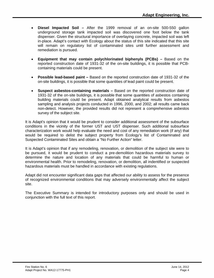
• Diesel Impacted Soil – After the 1999 removal of an on-site 500-550 gallon underground storage tank impacted soil was discovered one foot below the tank dispenser. Given the structural importance of overlaying concrete, impacted soil was left in-place. Adapt’s contact with Ecology about the status of this site indicated that this site will remain on regulatory list of contaminated sites until further assessment and remediation is pursued.
• Equipment that may contain polychlorinated biphenyls (PCBs) – Based on the
reported construction date of 1931-32 of the on-site buildings, it is possible that PCB-containing materials could be present.
• Possible lead-based paint – Based on the reported construction date of 1931-32 of the
on-site buildings, it is possible that some quantities of lead paint could be present. • Suspect asbestos-containing materials – Based on the reported construction date of
1931-32 of the on-site buildings, it is possible that some quantities of asbestos containing building materials could be present. Adapt obtained analytical results from asbestos sampling and analysis projects conducted in 1996, 2000, and 2002; all results came back non-detect. However, the provided results did not represent a comprehensive asbestos survey of the subject site.
It is Adapt’s opinion that it would be prudent to consider additional assessment of the subsurface conditions in the vicinity of the former UST and UST dispenser. Such additional subsurface characterization work would help evaluate the need and cost of any remediation work (if any) that would be required to delist the subject property from Ecology’s list of Contaminated and Suspected Contaminated Sites and obtain a “No Further Action“ letter. It is Adapt’s opinion that if any remodeling, renovation, or demolition of the subject site were to be pursued, it would be prudent to conduct a pre-demolition hazardous materials survey to determine the nature and location of any materials that could be harmful to human or environmental health. Prior to remodeling, renovation, or demolition, all indentified or suspected hazardous materials must be handled in accordance with existing regulations. Adapt did not encounter significant data gaps that affected our ability to assess for the presence of recognized environmental conditions that may adversely environmentally affect the subject site. The Executive Summary is intended for introductory purposes only and should be used in conjunction with the full text of this report.

Adapt Engineering, Inc.
Fire Station No. 6 June 14, 2012 Adapt Project No. WA12-17775-PH1 Page 5
2.0 INTRODUCTION 2.1 Purpose The purpose of the Phase I is to evaluate the subject site for readily apparent recognized environmental conditions. Where applicable, the Phase I also strives to satisfy one of the requirements to qualify for the innocent purchaser/landowner defense to Comprehensive Environmental Response, Compensation and Liability Act, 42, U.S.C. 9601, et seq. (CERCLA) liability. The Washington Model Toxics Control Act (MTCA), Chapter 70.105D Revised Code of Washington (RCW) has a similar provision for exemption from liability. The Phase I endeavors to provide “all appropriate inquiry into the previous ownership and uses of the property consistent with good commercial or customary practice in an effort to minimize liability” as stated in CERCLA and MTCA. 2.2 Scope of Work The scope of work for this study consisted of gathering reasonably ascertainable information in general accordance with the American Society for Testing and Materials (ASTM) Standard Practice for Phase I Environmental Site Assessments (ASTM Practice E 1527-05). Specifically, this Phase I consisted of the following:
• A reconnaissance to assess the subject site and the parcels immediately surrounding the subject site for recognized environmental conditions.
• A review of regulatory agency (U.S. Environmental Protection Agency, Washington State
Department of Ecology, etc.) database lists, and individual site files, if necessary, to evaluate reported environmental concerns near the subject site.
• A survey of available local geologic and topographic maps, as well as additional
information concerning public and private water sources in the subject site vicinity.
• A review of historical sources including available business directories, aerial photographs, maps, tax assessment records, and building/planning department records. The historical information was used to evaluate past and present land use at the subject site and immediate surrounding area to document businesses, activities, or conditions that could possibly compromise the environmental integrity of the subject site.
• A limited visual survey for suspect asbestos-containing materials (ACMs) for the site
building to make the client aware of the presence of building materials that may contain asbestos. The Limited Visual ACM Survey does not satisfy the "Good Faith Inspection" requirements specified in Chapter 296-62-07721 Washington Administrative Code (WAC), and other federal, state, and local regulations for buildings that are to be renovated or demolished.
• Preparation of a report documenting the findings of the Phase I and our opinion of the
possibility that contamination of the subject site may exist due to on-site or nearby off-site land use activities.
Adapt Engineering, Inc.
Fire Station No. 6 June 14, 2012 Adapt Project No. WA12-17775-PH1 Page 6
2.3 Significant Assumptions This assessment is intended to provide the client with information regarding apparent suspicions of existing and potential recognized environmental conditions associated with the subject property. Adapt warrants that this Phase I Environmental Site Assessment was performed using generally accepted, good commercial and customary environmental assessment practices. Adapt believes that the information obtained from the records review and the interviews concerning the site is reliable. However, Adapt cannot and does not warrant or guarantee that the information provided by these other sources is accurate or complete. No other warranty, either implied or express is given. 2.4 Limitations and Exceptions Environmental impairment of property because of activities such as illicit or unreported dumping or spilling of hazardous or deleterious materials may not be readily apparent. The opinions and conclusions presented in this report are based on information readily available at the time of the assessment. The collection of quantitative information, such as data generated by the analysis of soil or water samples, was beyond the scope of this assessment. The Phase I does not address the ASTM Phase I non-scope issues including: radon, lead in drinking water, regulatory compliance, cultural and historic resources, industrial hygiene, health and safety, ecological resources, endangered species, indoor air quality, biological agents, and mold. Other project specific limitations are presented in the appropriate sections of this report. 2.5 Special Terms and Conditions Authorization to perform this project was given via email from Mr. Louis Webster on May 9, 2012. 2.6 User Reliance This report has been prepared for the exclusive use of City of Seattle, and their agents for specific application to the subject site. Use or reliance upon this report by a third party is at their own risk. Adapt does not make any representation or warranty, express or implied, to such other parties as to the accuracy or completeness of this report or the suitability of its use by such other parties for any purpose whatever, known or unknown, to Adapt. 3.0 SUBJECT SITE DESCRIPTION A Location and Topographic Map (Figure 1), Parcel Map / 2009 Aerial Photograph (Figure 2), and Site & Vicinity Plan / 2011 Aerial Photograph (Figure 3) are attached to the end of this report. Photographs are included in Appendix A. Property information and abbreviated legal descriptions presented in Section 3.0 are based on in part on King County Assessor records. 3.1 Location and Legal Description The subject site comprises one tax parcel (Parcel No. 9826701650) located at 101 23rd Avenue South (23rd Ave S) in Seattle, Washington 98114 (Northwest Quarter of Section 04, Township 24, Range 04, E. Willamette Meridian). The approximately rectangular shaped site is reported to be 0.47 acres (20,400 sq ft) in size. According to the King County Department of Assessment,

Adapt Engineering, Inc.
Fire Station No. 6 June 14, 2012 Adapt Project No. WA12-17775-PH1 Page 7
there is a one-story, 8,130 square foot (sq ft) structure on the subject site which was constructed in 1931. The parcel number and legal description for the site are listed below: Parcel 9826701650, YESLERS H L 1ST ADD & VAC ST ADJ According to the City of Seattle Zoning Map (copyrighted 2008), the subject site is located in an area that is designated “LR3 - Low Rise 3.” On the zoning map the subject site is designated as a “City Designated Landmark.” According to the United States Geological Survey (USGS) 7.5-minute series topographic map “Seattle South E, WA” (1983, Base 1978), the elevation of the subject site ranges between 309 and 297 ft above mean sea level. Topographically, the subject site has a downward slope generally to the west. 3.2 Site and Vicinity Characteristics The site is situated in an area of mixed residential/municipal development within Seattle. The site is currently occupied by one structure further described in Section 3.3. The following is a brief description of each of the adjoining properties: North The parcel adjoining the site to the north, across East Yesler Way (E Yesler Way), addressed 103-109 23rd Ave, supports three renovated historic houses which are now luxury condominiums. The Yesler Houses are listed as a designated city landmark as they are some of the last standing grand Queen Anne-style houses that once filled Seattle. In the late 1990’s the three houses were renovated and turned into luxury condominiums. Northeast The parcel adjoining the site to the northeast, across E Yesler Way and 23rd Ave, addressed 2300 E Yesler Way, supports the Douglass-Truth Library. The library is a designated city landmark and serves as a community library. East and Southeast The parcel adjoining the site to the east and southeast, across 23rd Ave S, addressed 100 23rd Ave S, supports the Randolph Carter Family and Learning Center for Catholic Community Services. This building serves as a community center. South The parcel adjoining the site to the south, addressed 113 23rd Ave S, supports a retirement and assisted living residential development called The Cannon House. West The parcel adjoining the site to the west, addressed 2211-2215 E Yesler Way, supports residential townhouses. Northwest The parcel adjoining the site to the northwest, across E Yesler Way, 106 22nd Ave, supports an apartment building.

Adapt Engineering, Inc.
Fire Station No. 6 June 14, 2012 Adapt Project No. WA12-17775-PH1 Page 8
3.3 Current Uses of the Property and Description of Improvements The subject site has one building on-site which reportedly is a one-story, 8,130 sq ft building which serves as a fire station for the City of Seattle Fire Department. According to the King County Department of Assessment, the building is composed of the following two sections: a 4,878 sq ft fire station with the use code “Fire Station (staffed) 322”; and a 3,252 sq ft basement with the use code “Basement, Unfinished 703”. There are two paved parking areas on the subject site located on the east and west sides of the property and the remainder of the site is landscaped. The site is located on the southwest side of the intersection of 23rd Ave S and E Yesler Way. The site is accessed from both 23rd Ave S and E Yesler Way. 4.0 USER PROVIDED INFORMATION Louis Webster completed the ASTM Practice E 1527-05 User Questionnaire for the subject site and the responses are presented below. A copy of the User Questionnaire is included in Appendix B. 4.1 Title Records A title report-search for the subject site was not completed for this Phase I. 4.2 Environmental Liens or Activity and Use Limitations Interviews and the user questionnaire did not reveal environmental liens existing against the subject property. However, Mr. Webster did indicate that there are activity and land use restrictions in place on the site, adding the note:
“The property has been designated a historic landmark by the City of Seattle per Ordinance 122426. The existing zoning of the property is LR3.”
4.3 Specialized Knowledge Mr. Webster indicated that he has specialized knowledge or experience related to the property or nearby properties, adding the note:
“This response relates to and is the basis for all answers on the Questionnaire. For purposes of this Questionnaire, the City of Seattle is the “USER” of this ESA. The City of Seattle has working knowledge of this property. Upon request, staff of the City’s Department of Finance and Administrative Services (FAS) as well as the Fire Department can provide specialized knowledge of fire department operations. In addition, they may have information regarding current and prior tenants. In preparation for the anticipated sale of this property, reasonably and currently accessible records relating to the property were reviewed including King County Assessor records, City Clerk records, City Fleets and Facilities Capital Programs Division, Facilities Division Property Management and maintenance records, Seattle Fire Department records and City Fire Marshal’s Office records. The net result of the review of the record is presented in this User Questionnaire. This site is currently a municipal fire station and has been since improvements were constructed for that purpose in 1931. Regarding chemicals that may have been stored or used on the site, the Seattle Fire Department was asked what chemicals were used or stored at Fire Station 6. Captain Kenneth Whitehair responded by saying that Seattle Fire Department maintains a list of
Adapt Engineering, Inc.
Fire Station No. 6 June 14, 2012 Adapt Project No. WA12-17775-PH1 Page 9
chemicals that may be stored on or used at any fire station location throughout the City. Said list is available on line at the following link: http://www.seattlefire.msdss.com/MSDSSearch.aspx?fm=0&%5bTime%5db=0 and is attached for convenience.”
4.4 Valuation Reduction for Environmental Issues Mr. Webster indicated that the value of the property doe not reasonably reflects the fair market value of the property, adding the note:
“Not at present, as the sales price for this property has yet to be determined. The sales price will be based on fair market value. Contamination is not known or believed to be present on the property based on the information search.”
4.5 Commonly Known or Reasonably Ascertainable Information Mr. Webster indicated that he has knowledge of commonly known or reasonably ascertainable conditions indicative of releases or threatened releases occurring on the subject site. Mr. Webster answered the question addressing each of its four parts as follows:
“Question 5a: On behalf of the City, the search for information revealed fire station use since 1931. Other uses may have occurred prior to development of this property in 1931. Question 5b: On behalf of the City, the search for information revealed that an underground fuel storage tank (UST) was removed as evidenced in the UST Field Notes from Gary Struthers dated 12/9/1999. Tests revealed no asbestos in samples from the site, (See reports from Clayton Group Services dated 10/1/1996), 12/15/2000 and 1/28/2002 [sic] The information search did reveal a list of chemicals that may have been stored or used at any of the fire stations in the City. See list attached. The information search did not reveal other specific chemicals that are present or were once present at the property. Question 5c: On behalf of the City, the information search revealed no specific evidence of chemical releases, beyond what is reported in the UST Field Notes from Gary Struthers dated 12/9/1999. Question 5d: On behalf or the City, the information search revealed that an underground fuel storage tank (UST) was located south of the equipment bay doors, adjacent to the building on the 23rd Avenue S. side was removed in 1999. It is not known if there was any fuel contamination or clean up related to the UST.”
4.6 Presence or Likely Presence of Contamination at the Property Mr. Webster indicated that there is a degree of obviousness of the presence or likely presence of contamination at the property, adding the following note:
“The information search revealed no obvious indicators that point to the presence or likely presence of contamination at the property.”
4.7 Owner, Property Manager, and Occupant Information According to the King County Assessor records available online, the subject site is owned by the City of Seattle FAS. Management of the property is the responsibility of the City of Seattle Fire Department. The subject site is currently occupied by City of Seattle Fire Department Battalion 5.

Adapt Engineering, Inc.
Fire Station No. 6 June 14, 2012 Adapt Project No. WA12-17775-PH1 Page 10
4.8 Reason for Performing the Phase I The Phase I is being performed to satisfy financing requirements and to secure liability protection as discussed in Section 2.1. 5.0 PHYSICAL SETTING 5.1 Regional Physiographic Conditions Glacially derived sediments characterize the geology of the subject site area. These sediments were deposited and eroded during past glaciation periods, which ended about 13,500 years ago. The advance of the Vashon Glacier deepened and widened north-south trending valleys. Thick bodies of sand, gravel, and till were deposited over the greater Puget Sound area. With the retreat of the glacier, ice-contact stratified drift was deposited over much of the area. This was followed by a period of alluvial valley filling, localized peat deposition, minor erosion, and soil development. 5.2 Geologic and Soil Conditions According to the USGS "Geological Map of Seattle – a progress report" (Troost, K. A., Booth, D. B., Wisher, A. P., and Shimel, S. A., 2005, Open-File Report 2005-1252), the geologic unit under the subject site is Qvt-Vashon Till. Vashon Till is described as, “compact diamict of silt, sand and sub-rounded to well-rounded gravel, glacially transported and deposited under ice.” According to the United States Department of Agriculture Natural Resources Conservation Service (NRCS) Web Soil Survey map, there are no soil data available for the soils underlying the subject site. 5.3 Groundwater Conditions Groundwater conditions should be expected to fluctuate due to season, amount of precipitation, and other on-site and off-site factors. Reviewed well reports for wells reported to reside within ¼-mile of the subject site did not indicate encountering groundwater in the site vicinity. The deepest well log reviewed extended to 45 ft below ground surface (bgs) and did not report encountering water. Due to the subject site’s proximity to these wells, groundwater conditions under the site could be similar. Although groundwater flow direction is difficult to predict without the installation of at least three monitoring wells that measure water levels over time, an estimate of possible near-surface groundwater flow direction is provided to help evaluate potential on-site and off-site contaminant impacts. Groundwater flow direction is the path along which dissolved contaminants might migrate if present in groundwater supplies. The subject site and surrounding area are situated in a location that slopes downward towards the west, thus near surface groundwater is likely to flow towards the west. Variations in the assumed flow direction may exist that would remain uncharacterized without performing a subsurface exploration program with groundwater monitoring wells, which is beyond the Phase I scope of work. 5.4 Wetlands and Critical Areas The site reconnaissance did not reveal wetlands on the subject site. In addition, no natural standing bodies of water or typically hydrophytic vegetation were observed on the subject

Adapt Engineering, Inc.
Fire Station No. 6 June 14, 2012 Adapt Project No. WA12-17775-PH1 Page 11
property during the site reconnaissance. A wetlands map for the subject property prepared by the United States Fish and Wildlife Service was reviewed online. No designated wetlands were identified on the subject site or in the vicinity of the subject site. The closest designated wetland is located approximately 0.4 miles south of the subject site. 5.5 Drinking Water Supplies and Water Wells The subject site and the surrounding area obtain their public drinking water supply from City of Seattle. The city obtains water from the Cedar River and Tolt River watersheds in the southeast and northeast portions of King County, respectively. Based on separation distance, possible contamination on the subject site is unlikely to influence the drinking water sources. A review of Department of Ecology Well Records did not reveal active domestic or municipal water supply wells in within ½-mile of the subject site. 6.0 HISTORICAL USE INFORMATION This section is divided into four subsections. The first subsection (Section 6.1) summarizes the various historical sources that were consulted and subsequent subsections (Section 6.2, 6.3, & 6.4) provide a discussion of the historical uses of the subject site and immediate surrounding area. 6.1 Historical Sources The land use history of the subject site and immediate surrounding area was researched utilizing the various reasonably ascertainable sources described below. Tax Assessment and Archival Records Tax assessment information was obtained on-line from the King County Assessor’s Office. Adapt also obtained copies of archival tax assessment records available at the Puget Sound Regional Archives in Bellevue, WA on May 23, 2012. Adapt reviewed all available archived permitting documents for the subject site located at the offices of City of Seattle Department of Planning and Development on May 29, 2012. Department of Ecology Adapt reviewed environmental regulatory records available at the Washington State Department of Ecology (Ecology), Bellevue, WA. Ecology's archives includes sites that have encountered some environmental circumstance which elicit listing and documentation of environmental hazards located on-site. On June 13, 2012 Adapt reviewed files for the subject site. Department of Planning and Development Adapt reviewed permit records available online from the City of Seattle Department of Planning and Development (DPD) using the Permit and Complaint Status tool. This reportedly includes project, permit and case information from 1983 to present. In addition, Adapt view archived permit and land use plans at the DPD Seattle main office. Aerial Photographs Adapt reviewed aerial photographs from the years 1956, 1965, 1968, 1977, 1980, 1985, 1990, and 2006. The photographs range in scale from 1": 1,000' to 1": 2,000', and are black and white and color. Additional aerial photographs were available through the King County Assessors online parcel viewer (1936, 1998, 2000, 2002, 2005, 2007, and 2009) and Google Maps (1990, 2002, 2003, 2004, 2006, 2007, 2009, 2010, and 2011). In the review of the aerial photographs,

Adapt Engineering, Inc.
Fire Station No. 6 June 14, 2012 Adapt Project No. WA12-17775-PH1 Page 12
observations are interpretative and limited to the area within approximately one-quarter-mile of the subject site. The scale of each photograph did not provide a clear image of specific site characteristics. However, we were able to discern the absence and presence of structures on the subject site, as well as developmental trends in the area. Historical Maps Adapt reviewed the USGS 7.5-minute series topographic map “Seattle South E, WA” (1983, base 1978). Adapt also reviewed the USGS' "Geological Map of Seattle – a progress report" (Troost, K. A., Booth, D. B., Wisher, A. P., and Shimel, S. A., 2005, Open-File Report 2005-1252). Adapt reviewed historical maps at the Seattle Public Library including: the 1920, 1930, 1966, and 1995 Kroll Atlases for the City of Seattle. Adapt reviewed the on-line database collection of Sanborn Map Company fire insurance maps available from EDR. Sanborn maps, as they are commonly referred, typically detail building construction type and use, and may show underground and above ground storage tanks, chemical storage areas, and other recognized environmental conditions. The Sanborn Map Company published maps dating from 1867 to the present for various cities and towns, and therefore the maps are a good source for identifying the past uses of a property. The reviewed Sanborn map collection had coverage of the site and vicinity, dated 1905, 1917, and 1950. Business Directories In an effort to document past occupants of the subject site addresses and immediate surrounding addresses, Adapt typically reviews available historical business directories that include reverse street directories such as those published by R.L. Polk & Company and Cole Publications, commonly known as Polk and Cole directories. Adapt reviewed the collection of business directories available at the Seattle Public Library including Polk Directories for the City of Seattle with coverage of the subject site and vicinity from the years 1939, 1948-49, 1957, 1966, and 1975; and Cole directories for the City of Seattle from the years 1984-85, 1993-94, 2002, and 2011. Environmental Reports The environmental reports reviewed were an additional source of historical information. The following environmental reports for subject site were provided by the property contact and are on file with Adapt:
• "UST Site Assessment Report, Fire Station #6, 101 23rd Avenue South, Seattle, Washington." Prepared by Garry Struthers Associates, Inc. (Project No.: 95-044 Phase 5 Task 12), prepared for The City of Seattle - Executive Services Department, dated February 9, 2000;
• "Report on Designation, Seattle Fire Station #6, 101 23rd Avenue South, Seattle, Washington" Prepared by The City of Seattle - Landmarks Preservation Board (Project No.: LPB 272/05), prepared for The Historic Preservation Program - The Seattle Department of Neighborhoods, dated June 28, 2005;
• “Roof Evaluation, Fire Station #6, 101 23rd Avenue South, Seattle, Washington" Prepared by Wetherholt and Associates, P.S. (Project No.: 0002-06G), prepared for The City of Seattle - Executive Services Department, dated July 24, 2000.
• “Boundary Survey, Fire Station No. 6, E. Yesler Way Site" Prepared by Jones Associates, Inc. (Project No.: 81034, Rec. No. 8), prepared for Streeter/Dermanis A.I.A., dated May, 1981.

Adapt Engineering, Inc.
Fire Station No. 6 June 14, 2012 Adapt Project No. WA12-17775-PH1 Page 13
EDR Historical Information The EDR report reviewed (see Section 8.0 and Appendix C) contained proprietary lists of Historical Auto Stations and Historical Cleaners in the subject property vicinity, which corroborated information obtained from other historical information sources. Interviews Persons who may have information concerning environmental conditions at and surrounding the subject site were interviewed (see section 9.0). Pertinent information obtained during these interviews appears below and in the appropriate sections of this report.
6.2 Subject Site Earliest reviewed historical resources, maps dated 1893, show the subject site and vicinity as a slightly developed urban area supporting mostly residential dwellings. Reportedly in 1894, a wood-framed structure was constructed on the subject site to house the City of Seattle Fire Department’s Engine Company No. 6. This structure remained on-site until the construction of the current building, beginning approximately in 1931. Reportedly in 1932, the current Fire Station No. 6 building was completed and immediately occupied by Engine Company No. 6. Appendix D includes a floor plan for the basement level of the subject site dated 1931. The basement level floor plan indicates the location of the prior boiler room, fuel room, and a kitchen. The subject site has supported the City of Seattle Fire Department since its development. The current building has undergone various maintenance and updating projects throughout the years. Reportedly in 1986-87, the building underwent an interior remodel and the construction of a 1,210 sq ft addition to the south side of the building. Adapt obtained results from asbestos sampling and analysis projects conducted in 1996, 2000, and 2002; all results came back non-detect. Adapt also obtained files detailing the residence and decommissioning of a 500-550 gallon underground storage tank (UST) located on the east side of the building. Reportedly, the UST was installed in 1964 and decommissioned in 1999, more details are provided in Sections 8.5 and 8.6. 6.3 Adjoining Sites Based on data collected, including aerial photographs, maps, tax records, directories, and interviews, the following land-use history was determined for the adjoining properties. Earliest reviewed historical resources, maps dated 1893, show the subject site vicinity as a slightly developed urban area supporting mostly residential dwellings. A more detailed description of the land-use histories of the adjoining properties is as follows: North The parcel adjoining the site to the north, across E Yesler Way, addressed 103-109 23rd Ave, supports three renovated historic houses which are now luxury condominiums. The Yesler Houses are listed as a designated city landmark as they are some of the last standing grand Queen Anne-style houses that once filled Seattle. It appears that this adjoining site was undeveloped prior to the construction of the Yesler Houses in 1900. In the late 1990’s the three houses were renovated and turned into luxury condominiums.

Adapt Engineering, Inc.
Fire Station No. 6 June 14, 2012 Adapt Project No. WA12-17775-PH1 Page 14
Northeast The parcel adjoining the site to the northeast, across E Yesler Way and 23rd Ave, addressed 2300 E Yesler Way, supports the Douglass-Truth Library. It appears that this adjoining site was undeveloped prior to the construction of the branch of the Seattle Public Library in 1913. The library is a designated city landmark and serves as a community library. East and Southeast The parcel adjoining the site to the east and southeast, across 23rd Ave S, addressed 100 23rd Ave S, currently supports the Randolph Carter Family and Learning Center for Catholic Community Services. Prior to the current building’s construction in 1971, this adjoining site was occupied by a 16 unit apartment building reportedly built in the 1940’s. Prior to the apartment building, there was a mixed retail/residential building on this adjoining site whose tenants included a drug store, a bakery, and a plumbing/cleaning store. South The parcel adjoining the site to the south, addressed 113 23rd Ave S, supports a retirement and assisted living residential development called The Cannon House. Prior to the construction of the Cannon House in 2001, these adjoining parcels supported residential dwellings. West The parcel adjoining the site to the west, addressed 2211-2215 E Yesler Way, supports residential townhouses. Prior to the construction of the townhouses in 2007, these adjoining parcels supported residential dwellings. Northwest The parcel adjoining the site to the northwest, across E Yesler Way, 106 22nd Ave, supports an apartment building. Prior to the construction of the apartment building in 1970, this adjoining parcel supported residential dwellings. 6.4 Historically Significant or Environmental Findings Reviewed business directories, aerial photographs, tax records, permits, historical maps, and associated interviews suggest that the subject site has supported a fire station since 1894. The historical review did not reveal the past presence of businesses of environmental concern, such as gas stations, heavy industry, or dry cleaners, being present on the subject site. However, it is known that the site has had an UST resident on the property, reportedly from 1964 to 1999. It is believed that contamination is still present in the area of the former UST. This issue is further detailed in Sections 8.5 and 8.6. The historical review did not reveal any recognized environmental conditions related to the adjoining properties.
Adapt Engineering, Inc.
Fire Station No. 6 June 14, 2012 Adapt Project No. WA12-17775-PH1 Page 15
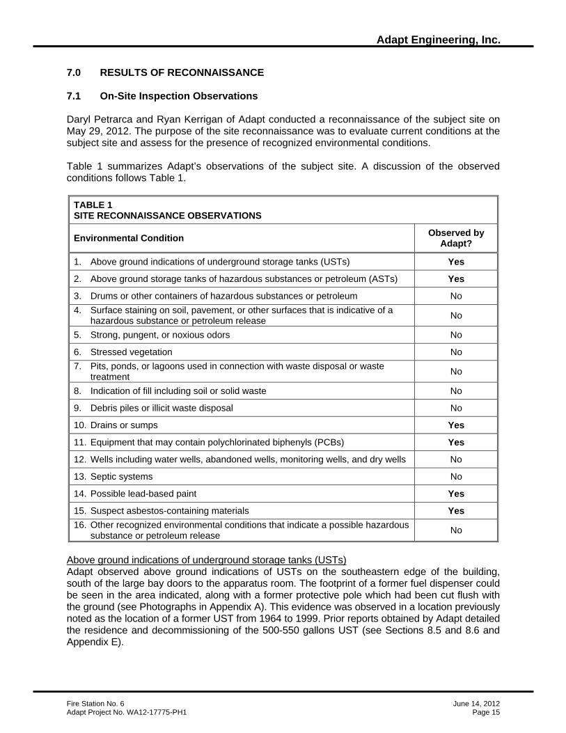
7.0 RESULTS OF RECONNAISSANCE 7.1 On-Site Inspection Observations Daryl Petrarca and Ryan Kerrigan of Adapt conducted a reconnaissance of the subject site on May 29, 2012. The purpose of the site reconnaissance was to evaluate current conditions at the subject site and assess for the presence of recognized environmental conditions. Table 1 summarizes Adapt’s observations of the subject site. A discussion of the observed conditions follows Table 1.
TABLE 1 SITE RECONNAISSANCE OBSERVATIONS
Environmental Condition Observed by Adapt?
1. Above ground indications of underground storage tanks (USTs) Yes
2. Above ground storage tanks of hazardous substances or petroleum (ASTs) Yes
3. Drums or other containers of hazardous substances or petroleum No 4. Surface staining on soil, pavement, or other surfaces that is indicative of a
hazardous substance or petroleum release No
5. Strong, pungent, or noxious odors No
6. Stressed vegetation No 7. Pits, ponds, or lagoons used in connection with waste disposal or waste
treatment No
8. Indication of fill including soil or solid waste No
9. Debris piles or illicit waste disposal No
10. Drains or sumps Yes
11. Equipment that may contain polychlorinated biphenyls (PCBs) Yes
12. Wells including water wells, abandoned wells, monitoring wells, and dry wells No
13. Septic systems No
14. Possible lead-based paint Yes
15. Suspect asbestos-containing materials Yes 16. Other recognized environmental conditions that indicate a possible hazardous
substance or petroleum release No
Above ground indications of underground storage tanks (USTs) Adapt observed above ground indications of USTs on the southeastern edge of the building, south of the large bay doors to the apparatus room. The footprint of a former fuel dispenser could be seen in the area indicated, along with a former protective pole which had been cut flush with the ground (see Photographs in Appendix A). This evidence was observed in a location previously noted as the location of a former UST from 1964 to 1999. Prior reports obtained by Adapt detailed the residence and decommissioning of the 500-550 gallons UST (see Sections 8.5 and 8.6 and Appendix E).

Adapt Engineering, Inc.
Fire Station No. 6 June 14, 2012 Adapt Project No. WA12-17775-PH1 Page 16
Above ground storage tanks of hazardous substances or petroleum (ASTs) Adapt observed a large backup generator in the southwest corner of the basement level of the subject site building. Below the generator was an AST identified by a fill port cap with the hand-written label, “Diesel Only.” Also the side of the AST was hand labeled, “Approx. 80 GAL” which corresponds to the perceived size of the AST. Both the generator and AST appear to be in good condition with no sign of releases in the vicinity. Drains or sumps Adapt observed a sewer clean out drain in the central portion of the basement level of the subject site building. The sewer clean out drain is accessed by an approximately 18” man-hole cover and appears to be in good condition. Equipment that may contain polychlorinated biphenyls (PCBs) Adapt observed fluorescent light fixtures within several the subject property buildings. Fluorescent light ballasts within fixtures manufactured prior to 1977 sometimes contained PCBs. The fixtures appeared to be in good physical condition. Based on the reported construction date of 1931-32, it is possible that PCB-containing ballasts could be present. A comprehensive survey for PCB ballasts was beyond the scope of work for the present Phase I assessment. Ballasts without "No PCBs" labels should be assumed to contain PCBs. In case of future repair work, remodeling, or demolition of the fluorescent lights, certain regulations concerning the disposal of the ballasts must be followed. EPA Region 10 has established a policy that PCB ballasts must be disposed of in a chemical waste landfill or in a high-temperature incinerator. Possible lead-based paint The federal government banned lead-based paint in 1978 for residential and commercial use. Based on the reported construction date of 1931-32, it is possible that some quantities of lead paint could be present. Adapt's limited visual screening revealed some painted surfaces that appeared to have substantial peeling or chipping paint. We recommend that Occupational Safety and Health Administration (OSHA) regulations be followed whenever paint that contains lead, regardless of the concentration, will be disturbed (e.g., during renovation or demolition). We understand that the proposed action on the subject site would include the demolition of the current structures; it is our recommendation that a pre-demolition hazardous survey is completed on the subject site structures and that all existing regulations are followed. Suspect asbestos-containing materials A limited visual screening for suspect asbestos-containing materials (ACMs) was conducted at the time of the site reconnaissance. Based on the reported construction date of 1931-32, it is possible that some quantities of ACMs could be present. Adapt obtained analytical results from asbestos sampling and analysis projects conducted in 1996, 2000, and 2002; all results came back non-detect. However, the provided results did not represent a comprehensive asbestos survey of the subject site. The Phase I included a limited visual survey for suspect asbestos-containing materials (ACMs) associated with the site buildings, however, this does not satisfy the "Good Faith Inspection" requirements specified in Chapter 296-62-07721 of the Washington Administrative Code (WAC), and other federal, state, and local regulations for buildings that are to be renovated or demolished. The limited visual survey involved a walkthrough of accessible areas of the site buildings and noting exposed building materials that are typically considered to be suspect ACMs. The quantity and exact locations of the suspect ACMs were not recorded. Suspect ACMs observed by Adapt
Adapt Engineering, Inc.
Fire Station No. 6 June 14, 2012 Adapt Project No. WA12-17775-PH1 Page 17
include laminate flooring materials and gypsum wallboard systems, and acoustical ceiling materials. Other possible ACMs may include thermal insulation, window glazings, fire doors, roofing materials, and wrapped piping that were not viewed at the time of our site visit. The observed suspect ACMs were in fair condition and did not appear to be friable. Prior to demolition or renovation, the local clean air agency and other federal and state regulations require that a U.S. EPA AHERA Building Inspector perform a more thorough, "good faith", asbestos survey. The survey would involve the collection and analytical testing of bulk samples of all suspect ACMs. If an asbestos survey confirms the presence of ACMs in a building, the ACMs must first be removed in accordance with applicable regulations prior to renovation or demolition. Potential costs for addressing asbestos issues are undetermined at this time. Depending on the type of ACM and the removal method, the removal may need to be performed by state certified asbestos workers. If ACMs are present, and not damaged, such materials can usually be managed in place with implementation of an appropriate Operations and Management Plan (O&M). 7.2 Adjacent Site and Vicinity Observations Daryl Petrarca and Ryan Kerrigan of Adapt conducted a reconnaissance of the subject site and vicinity on May 29, 2012. The purpose of this reconnaissance was to observe land use in the subject site vicinity and to evaluate the potential for nearby businesses to generate, use, or store hazardous substances that may affect the subject site. The off-site reconnaissance was generally non-intrusive with the adjoining properties observed from the subject site and public rights-of-way. The characteristics of adjoining parcels are described in section 3.2 of this report. Adapt did not observe readily apparent recognized environmental conditions on parcels immediately adjoining the subject site that in Adapt’s opinion, may adversely environmentally affect the subject site.

Adapt Engineering, Inc.
Fire Station No. 6 June 14, 2012 Adapt Project No. WA12-17775-PH1 Page 18
8.0 STANDARD REGULATORY AGENCY ENVIRONMENTAL RECORD SOURCES Publicly available and practically reviewable regulatory agency reports generated from databases were reviewed with respect to the subject property. The reports, obtained from federal, state, and local government agencies, were reviewed in an effort to document any reported environmental concerns that have occurred at the subject site or in the surrounding area. Current federal, state and county environmental database listings were obtained from Environmental Data Resources, Inc. (EDR) for the subject property and vicinity. The EDR report, dated May 14, 2012, was reviewed by Adapt to identify possible environmental concerns in the area of the subject site. These lists are not necessarily complete or fully up to date; the dates of the databases reviewed are included in the EDR report. The EDR report also includes a list of unmappable sites due to limited information available in the regulatory files. Adapt reviewed the list of unmappable sites for any listings in the proximity of the subject property and included them in the following database report where applicable. Due to its sheer volume, a printed copy of the EDR report is not included as Appendix C of the hard copy Phase I report; however, it can be viewed in its entirety in the electronic version submitted with the final report, and a copy of the EDR report will also be archived in Adapt's project file. The maps included in the EDR report depict facility locations that are approximate. Adapt crosschecks the addresses provided in the EDR report with non-EDR maps and field checks.
TABLE 2 SUMMARY OF REGULATORY AGENCY REPORTS
Report Report Date
Search Distance
Sites Within the Search Distance
National Priorities List (NPL) 1 Mile 0
Delisted NPL Sites 09/07/11
0.5 Mile 0 Non-NPL Comprehensive Environmental Response, Compensation, and Liability Information System (CERCLIS) Sites 0.5 Mile 0
CERCLIS No Further Remedial Action Planned (NFRAP) 12/27/11
0.5 Mile 0
Resource Conservation and Recovery Act (RCRA) Handlers –Generators
Property & Adjoining 0
RCRA Treatment, Storage and Disposal (TSD) Facilities 11/10/11
0.5 Mile 0
RCRA Corrective Action Report (CORRACTS) 08/19/11 1 Mile 0
Federal and State Institutional and Engineering Control Sites 12/30/11 Property Only 0
Emergency Response Notification System (ERNS) 10/03/11 Property Only 0
Ecology Confirmed and Suspected Contaminated Sites Report (CSCS) 1 Mile 44
Ecology CSCS No Further Action (NFA) Sites Report 01/24/12
0.5 Mile 4 Ecology Database of Registered Underground Storage Tank (UST) Facilities
Property & Adjoining 1
Ecology’s Database of Leaking Underground Storage Tank (LUST) Facilities
02/22/12 0.5 Mile 6
Ecology’s Voluntary Cleanup Program (VCP) and Independent Cleanup (ICR) Sites
01/24/12 & 12/01/02 0.5 Mile 10
Ecology’s Solid Waste Facility Database 10/11/11 0.5 Mile 0
Federal and state Brownfield sites 01/24/12 0.5 Mile 0
Adapt Engineering, Inc.
Fire Station No. 6 June 14, 2012 Adapt Project No. WA12-17775-PH1 Page 19
8.1 Superfund Program CERCLIS Database The Comprehensive Environmental Response, Compensation and Liability Information System (CERCLIS) is the national database and management system EPA uses to track activities at hazardous waste sites considered for cleanup under the Superfund Program. The database includes the National Priorities List (NPL) of sites with the highest priority for cleanup, sites that have been delisted from the NPL, sites that are being assessed for possible inclusion on the NPL, and sites with no further remediate action planned (NFRAP). NPL Sites EDR reports a September 7, 2011 version of the NPL does not include an NPL facility within one mile of the subject site. Delisted NPL EDR reports a September 7, 2011 version of an EPA listing does not include delisted NPL sites located within approximately ½-mile of the subject site. CERCLIS EDR reports a December 27, 2011 version of the CERCLIS database does not include non-NPL CERCLIS sites within approximately ½-mile of the subject site. CERCLIS-NFRAP EDR reports a December 27, 2011 version of the CERCLIS-NFRAP database does not include facilities within approximately ½-mile of the subject site. 8.2 Resource Conservation and Recovery Act (RCRA) Reports The Resource Conservation and Recovery Act (RCRA) was enacted to protect human health and the environment from the potential hazards of waste disposal and to ensure that wastes are managed in an environmentally sound manner. In general, all generators, transporters, treaters, storers, and disposers of hazardous waste are required to provide information about their activities to state environmental agencies, such as Ecology. These agencies then pass on the information to the EPA where it is entered into RCRAInfo, a national program management and inventory system of hazardous waste handlers. Ecology maintains a separate database of hazardous waste generators that is accessible via their web-based Facility/Site Identification (F/SID) System. RCRA Handlers-Generators EDR reports a November 10, 2011 version of the RCRAInfo database does not include facilities on or adjoining the subject site. RCRA TSD Facilities EDR reports a November 10, 2011 version of the RCRAInfo database does not include TSD facilities within ½-mile of the subject site. RCRA CORRACTS EDR reports an August 19, 2011 version of the CORRACTS Report does not include any facilities within one-mile of the subject site.

Adapt Engineering, Inc.
Fire Station No. 6 June 14, 2012 Adapt Project No. WA12-17775-PH1 Page 20
8.3 Federal Institutional Control/Engineering Control Registries EDR reports a December 31, 2011 federal listing of sites with institutional or engineering controls in place does not include the subject site. Additionally, EDR reports Ecology’s February 14, 2012 listing of sites with institutional controls does not include the subject site. 8.4 Emergency Response Notification System Spill Report The Emergency Response Notification System (ERNS) Spill Report is a national database used to collect information on reported accidental releases of oil and hazardous substances. The database contains information from spill reports made to federal authorities including the EPA, the United States Coast Guard, the National Response Center, and the United States Department of Transportation. EDR reports an October 3, 2011 version of the ERNS and it does not include a spill incident on the subject site. 8.5 Confirmed and Suspected Contaminated Sites (CSCS) Report Ecology's Confirmed and Suspected Contaminated Sites (CSCS) report is an inventory of suspected or confirmed hazardous substance sites in the state of Washington. The CSCS report may be considered the equivalent to both the federal NPL and CERCLIS thus the search distance is one mile. Ecology’s CSCS No Further Action (NFA) report contains information on sites that have been investigated and cleaned up and which previously appeared on the CSCS report. The CSCS NFA report may be considered the equivalent to the federal de-listed NPL and NFRAP thus the search distance is one-half-mile. CSCS EDR reports a January 24, 2012 version of the CSCS report which includes forty four (44) facilities within approximately one mile of the subject site (seven [7] of which are also on Ecology’s Hazardous Sites List [HSL]). Most of the revealed CSCS facilities appear to reside in locations that are sufficiently distant, and/or are inferred, based on topography, to be hydrogeologically cross/down gradient in relation to the subject site. It is unlikely that reported contamination at these facilities has impacted the subject site. However, one of the listed CSCS sites is the subject site. The CSCS listing originated after the 1999 removal of an underground storage tank (UST) formerly located on the east side of the building, south of the large bay door to the apparatus room (see Figure 3). A report received by Ecology, dated February 9, 2000, describes diesel impacts to the soil near the removed UST, below the fuel dispenser. The 2000 UST closure report describes that only one of the ten samples analyzed detected diesel contamination above the Model Toxics Cleanup Level (MTCA) Method A Action Level. The impacted soil was collected 1 ft below the dispenser and detected 2,600 parts per million (ppm) diesel (the MTCA Method A Action Level is 2,000 ppm for diesel, formerly 200 ppm in 2000). A sample collected from 2 ft below the dispenser detected 690 ppm diesel and a sample from 3.5 below the dispenser did not detect diesel impacts. The shallow diesel impacts were left in-place because the concrete slab above the impacts was determined to be of structural importance to the building. The diesel impacts related to the former UST on-site has landed the subject site on the following regulatory lists: CSCS, UST, Leaking UST (LUST), and Independent Cleanup Report (ICR). According to Sonia Fernandez of the Washington State Department of Ecology (Ecology) Voluntary Cleanup Program, Ecology recently conducted an assessment of approximately 1,400

Adapt Engineering, Inc.
Fire Station No. 6 June 14, 2012 Adapt Project No. WA12-17775-PH1 Page 21
‘older’ contaminated sites which was completed on August 8, 2011 and entered into the system on October 8, 2011. During this assessment Ecology reviewed the files for the subject site and determined that the site should remain on regulatory list as a ‘contaminated site’ until further remediation efforts are pursued. The current status of the site is listed as “cleanup started” according to Ecology’s website. CSCS NFA EDR reports a January 24, 2012 version of the CSCS NFA report which includes four (4) facilities within approximately ½-mile of the subject site. The revealed NFA facility resides in a location that is sufficiently distant and are inferred, based on topography, to be hydrogeologically cross gradient in relation to the subject site. Considering the NFA status, the separation distances, and topographic locations, it appears unlikely the reported contamination associated with these NFA facilities has affected the subject site. 8.6 Underground Storage Tanks Ecology's report of underground storage tanks (USTs) includes UST facilities that have been registered with the state of Washington, in accordance with the Washington UST Regulations (Chapter 173-360 WAC). EDR reports a February 22, 2012 version of Ecology’s UST report, which includes one (1) facility on the subject site or adjoining sites. The UST site is located on the subject site. Reportedly, in 1964 a steel, single wall, 500-550 gallon tank was installed on the subject site. The tank held diesel fuel for fueling trucks of the Fire Station located on site. On December 9, 1999 the tank was removed, during which contamination was encountered (see Section 8.5). 8.7 Leaking Underground Storage Tanks Ecology's leaking UST (LUST) list is limited to reported leaking USTs. EDR reports a February 22, 2012 version of Ecology’s LUST report, which includes six (6) LUST facilities within approximately one-half-mile of the subject site. Most the revealed LUST facilities appear to reside in locations that are sufficiently distant, and/or are inferred, based on topography, to be hydrogeologically cross/down gradient in relation to the subject site. It is unlikely that reported contamination at these facilities has impacted the subject site. However, one of the listed LUST sites is the subject site. As described in sections 8.5 and 8.6, during the 1999 removal of a 500-550 gallon diesel UST, contractors encountered diesel contamination in the soil one foot below the dispenser. The soil impacts were reported to Ecology on February 28, 2000. Ecology has three LUST status changes listed: cleanup started as of 12/09/1999; reported cleaned up as of 02/23/2000; and cleanup started as of 07/01/2011. 8.8 Voluntary Cleanup Sites Ecology maintains a database that includes sites in the Voluntary Cleanup Program (VCP) and sites that have undergone an independent cleanup. EDR reports Ecology’s January 24, 2012 listing of VCP sites and a December 1, 2002 listing of Independent Cleanup Reports (ICR) includes ten (10) sites within approximately ½-mile of the subject site. Most of the revealed VCP and ICR facilities appear to reside in locations that are sufficiently distant and/or are inferred, based on topography, to be hydrogeologically cross/down gradient in relation to the subject site. Considering separation distances, and topographic locations, it appears unlikely the reported

Adapt Engineering, Inc.
Fire Station No. 6 June 14, 2012 Adapt Project No. WA12-17775-PH1 Page 22
contamination associated with these facilities has affected the subject site. However, one of the listed ICR sites is the subject site. The ‘interim cleanup report’ ICR, received by Ecology on February 28, 2000, documents the petroleum product impacts to the soil on the subject site (also see Sections 8.5 - 8.7). 8.9 Landfills EDR reports an October 11, 2010 version of Ecology’s listing of Municipal Solid Waste (MSW) facilities located in the state of Washington which does not include sites within ½-mile of the subject site. 8.10 Brownfields EDR reports a January 24, 2012, EPA listing of brownfield sites which does not include sites within ½-mile of the subject site. 8.11 Tribal Records The subject site is not within the reservation boundaries of a federally recognized Indian tribe. According to the Washington Governor’s Office of Indian Affairs, the nearest Indian tribe reservation to the subject site is the Puyallup Indian Reservation located approximately 20-miles southwest of the subject site. 8.12 Additional Environmental Record Sources Included in the EDR report are additional federal and state environmental records not required for review under ASTM Standard E1527-05. The additional records are listed on pages 8-11 of the EDR report (see Appendix C).
Adapt Engineering, Inc.
Fire Station No. 6 June 14, 2012 Adapt Project No. WA12-17775-PH1 Page 23
9.0 INTERVIEWS Persons who may have information concerning the subject site and surrounding area were interviewed and are listed below. Pertinent information obtained during the interviews appears in appropriate sections of this report. All interviews were conducted by Ryan Kerrigan of Adapt.
• On May 15, 2012, Adapt conducted an email interview with Lauren Poole of the City of Seattle Fire Department Records Office concerning potential UST permits. According to Ms. Poole, the Fire Dept. has no permits for UST installation, residence, or removal for subject site.
• On May 15, 2012, Adapt conducted an email interview of Carol Dorn UST/LUST liaison for WA State Ecology concerning UST/LUST records.
• On May 15, 2012, Adapt conducted an email interview of Louis Webster of the Department of Finance and Adminstrative Services of the City of Seattle, one of the property contacts for the site.
• On May 22, 2012, Adapt conducted a telephone interview with Louis Webster. • On May 23, 2012, Adapt conducted a telephone interview with John Sheldon of the City
of Seattle. • On May 29, 2012, Adapt conducted a site visit with Louis Webster and Jeff Gunther of
the City of Seattle Fire Department. • On June 13, 2012, Adapt interviewed Cherie Gritsch of Central Records of the
Washington State Department of Ecology. • On June 13, 2012, Adapt interviewed Sonia Fernandez of the Voluntary Cleanup
Program of the Washington State Department of Ecology.

Adapt Engineering, Inc.
Fire Station No. 6 June 14, 2012 Adapt Project No. WA12-17775-PH1 Page 24
10.0 FINDINGS, OPINION, CONCLUSIONS AND DATA GAPS We have performed a Phase I Environmental Site Assessment in conformance with the scope and limitations of ASTM Practice E 1527-05 of Fire Station No. 6 located at 101 23rd Avenue South, Seattle, King County, Washington 98114 (see section 3.1). Any exceptions to, or deletions from, this practice are described in Section 2.0. This assessment did not reveal any suspect recognized environmental conditions except for the following:
• Diesel Impacted Soil – After the 1999 removal of an on-site 500-550 gallon underground storage tank impacted soil was discovered one foot below the tank dispenser. Given the structural importance of overlaying concrete, impacted soil was left in-place. Adapt’s contact with Ecology about the status of this site indicated that this site will remain on regulatory list of contaminated sites until further assessment and remediation is pursued.
• Equipment that may contain polychlorinated biphenyls (PCBs) – Based on the
reported construction date of 1931-32 of the on-site buildings, it is possible that PCB-containing materials could be present.
• Possible lead-based paint – Based on the reported construction date of 1931-32 of the
on-site buildings, it is possible that some quantities of lead paint could be present. • Suspect asbestos-containing materials – Based on the reported construction date of
1931-32 of the on-site buildings, it is possible that some quantities of asbestos containing building materials could be present. Adapt obtained analytical results from asbestos sampling and analysis projects conducted in 1996, 2000, and 2002; all results came back non-detect. However, the provided results did not represent a comprehensive asbestos survey of the subject site.
It is Adapt’s opinion that it would be prudent to consider additional assessment of the subsurface conditions in the vicinity of the former UST and UST dispenser. Such additional subsurface characterization work would help evaluate the need and cost of any remediation work (if any) that would be required to delist the subject property from Ecology’s list of Contaminated and Suspected Contaminated Sites and obtain a “No Further Action“ letter. It is Adapt’s opinion that if any remodeling, renovation, or demolition of the subject site were to be pursued, it would be prudent to conduct a pre-demolition hazardous materials survey to determine the nature and location of any materials that could be harmful to human or environmental health. Prior to remodeling, renovation, or demolition, all indentified or suspected hazardous materials must be handled in accordance with existing regulations. Adapt did not encounter significant data gaps that affected our ability to assess for the presence of recognized environmental conditions that may adversely environmentally affect the subject site. 11.0 DEVIATIONS The report format of the Phase I does not stringently follow the recommended format included in ASTM Standard E 1527-05, but Adapt believes the information required of the standard is presented herein.

Adapt Engineering, Inc.
Fire Station No. 6 June 14, 2012 Adapt Project No. WA12-17775-PH1 Page 25
12.0 ADDITIONAL SERVICES Adapt did not provide additional services for this report.
13.0 SIGNATURES OF ENVIRONMENTAL PROFESSIONALS We declare that, to the best of our professional knowledge and belief, we meet the definition of Environmental Professional as defined in §312.10 40 CFR 312. We have the specific qualifications based on education, training, and experience to assess a property of the nature, history, and setting of the subject property. We have developed and performed the all appropriate inquiries in conformance with the standards and practices set forth in 40 CFR Part 312. Respectfully Submitted, Adapt Engineering, Inc. Ryan J. Kerrigan, Ph.D., L.G. Geologist / Environmental Scientist Daryl S. Petrarca, L.H.G. Senior Reviewer
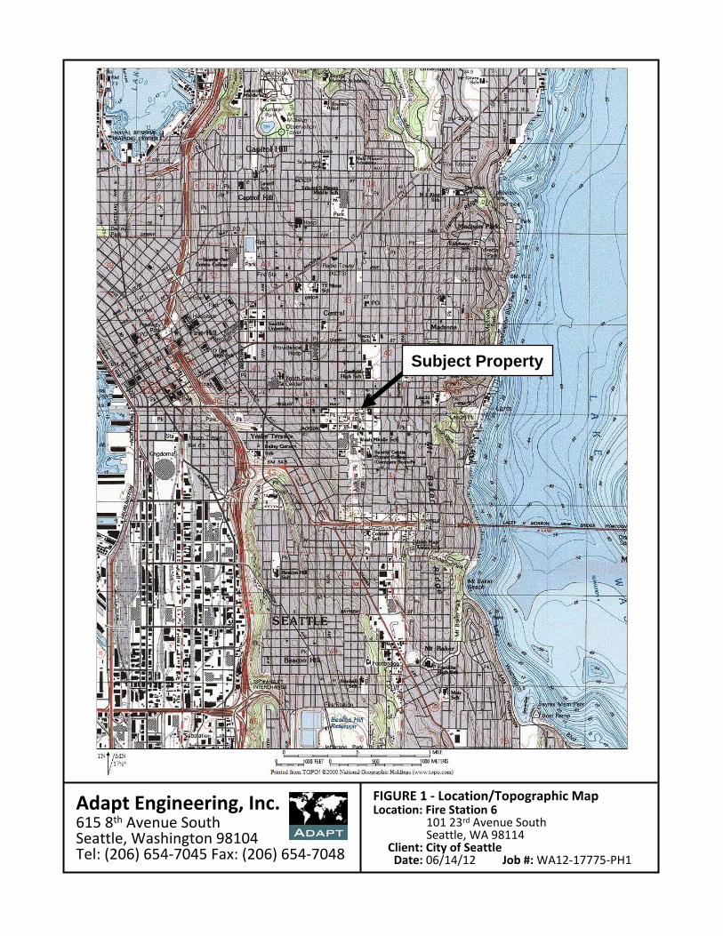
Adapt Engineering, Inc.615 8th Avenue SouthSeattle, Washington 98104Tel: (206) 654‐7045 Fax: (206) 654‐7048
FIGURE 1 ‐ Location/Topographic MapLocation: Fire Station 6
101 23rd Avenue SouthSeattle, WA 98114
Client: City of SeattleDate: 06/14/12 Job #:WA12‐17775‐PH1
Subject Property

Adapt Engineering, Inc.615 8th Avenue SouthSeattle, Washington 98104Tel: (206) 654‐7045 Fax: (206) 654‐7048
2323rdrd
Ave
nue
Sout
hA
venu
e So
uth
Subject SiteSubject Site98267016509826701650
98192000009819200000
FIGURE 2 ‐ Parcel Map / 2009 Aerial PhotoLocation: Fire Station 6
101 23rd Avenue SouthSeattle, WA 98114
Client: City of SeattleDate: 06/14/12 Job #:WA12‐17775‐PH1
East East YeslerYesler WayWay
2222ndnd
Ave
nue
Sout
hA
venu
e So
uth
98277000409827700040
982590000098259000009827700080982770008098277000859827700085
00076000970007600097
68407017356840701735
36461000053646100005
5569640000556964000036461000803646100080
36461000703646100070
36461000663646100066
36461000653646100065
36461001153646100115
36461001103646100110
36461001113646100111
36461001053646100105
3646
1001
2536
4610
0125
98267016169826701616
98267016109826701610
9826701615982670161598267016229826701622
98267016209826701620
98267016249826701624
98267016269826701626
9826701628982670162898267016459826701645
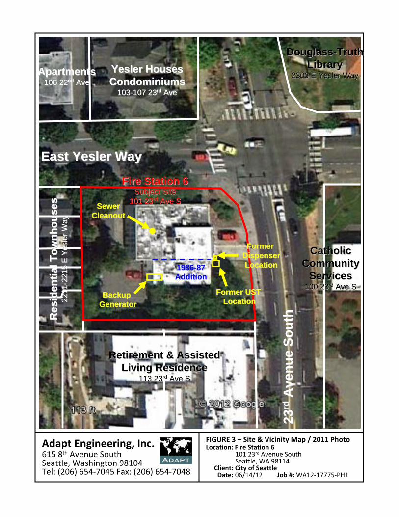
Adapt Engineering, Inc.615 8th Avenue SouthSeattle, Washington 98104Tel: (206) 654‐7045 Fax: (206) 654‐7048
FIGURE 3 – Site & Vicinity Map / 2011 PhotoLocation: Fire Station 6
101 23rd Avenue SouthSeattle, WA 98114
Client: City of SeattleDate: 06/14/12 Job #:WA12‐17775‐PH1
2323rdrd
Ave
nue
Sout
hA
venu
e So
uth
Fire Station 6Fire Station 6Subject SiteSubject Site
101 23101 23rdrd Ave SAve S
East East YeslerYesler WayWay
CatholicCatholicCommunityCommunity
ServicesServices100 23100 23rdrd Ave SAve S
DouglassDouglass--TruthTruthLibraryLibrary
2300 E 2300 E YeslerYesler WayWay
Retirement & AssistedRetirement & AssistedLiving ResidenceLiving Residence
113 23113 23rdrd Ave SAve S
Res
iden
tial T
ownh
ouse
sR
esid
entia
l Tow
nhou
ses
2211
2211
-- 221
5 E
2215
E Y
esle
rY
esle
r Way
Way
YeslerYesler HousesHousesCondominiumsCondominiums
103103--107 23107 23rdrd AveAve
ApartmentsApartments106 22106 22ndnd AveAve
Former UST Former UST LocationLocation
Former Former DispenserDispenserLocationLocation19861986--8787
AdditionAddition
SewerSewerCleanoutCleanout
Backup Backup GeneratorGenerator
Adapt Engineering, Inc.
Fire Station No. 6 June 14, 2012 Adapt Project No. WA12-17775-PH1 Appendix A - Photographs
APPENDIX A
PHOTOGRAPHS

Adapt Engineering, Inc.
Fire Station 6 Photographs Adapt Project No. WA12-17775-PHI Appendix A – Page 1
1. Looking west at the front of the building on the subject site
2. Looking southwest at the “Notice of Recom- mendation” located on the northeast corner of the subject site 3. Looking southwest at the southwest corner of the building on the subject site
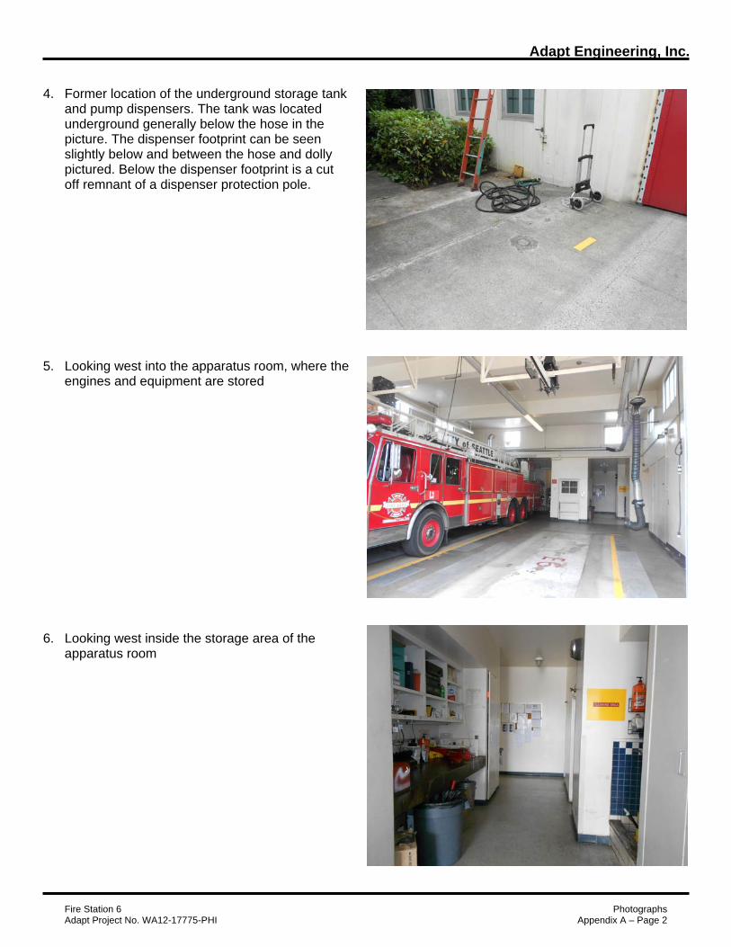
Adapt Engineering, Inc.
Fire Station 6 Photographs Adapt Project No. WA12-17775-PHI Appendix A – Page 2
4. Former location of the underground storage tank and pump dispensers. The tank was located
underground generally below the hose in the picture. The dispenser footprint can be seen slightly below and between the hose and dolly pictured. Below the dispenser footprint is a cut off remnant of a dispenser protection pole.
5. Looking west into the apparatus room, where the engines and equipment are stored 6. Looking west inside the storage area of the apparatus room
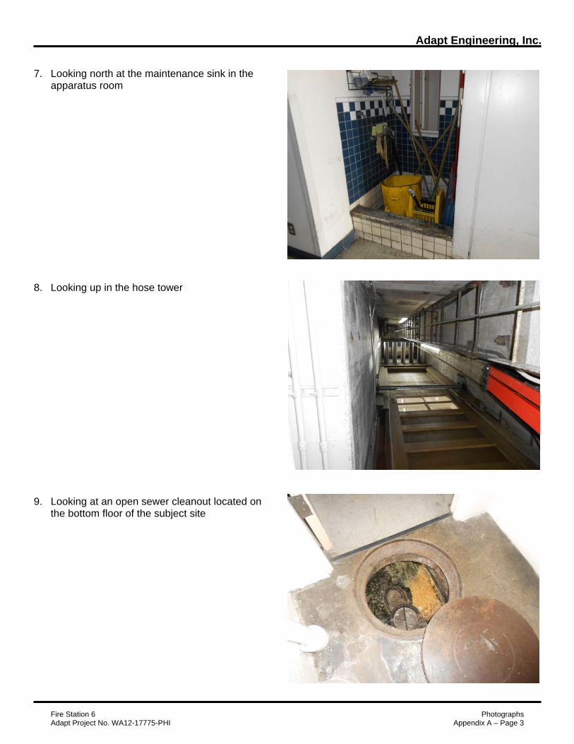
Adapt Engineering, Inc.
Fire Station 6 Photographs Adapt Project No. WA12-17775-PHI Appendix A – Page 3
7. Looking north at the maintenance sink in the apparatus room 8. Looking up in the hose tower
9. Looking at an open sewer cleanout located on the bottom floor of the subject site
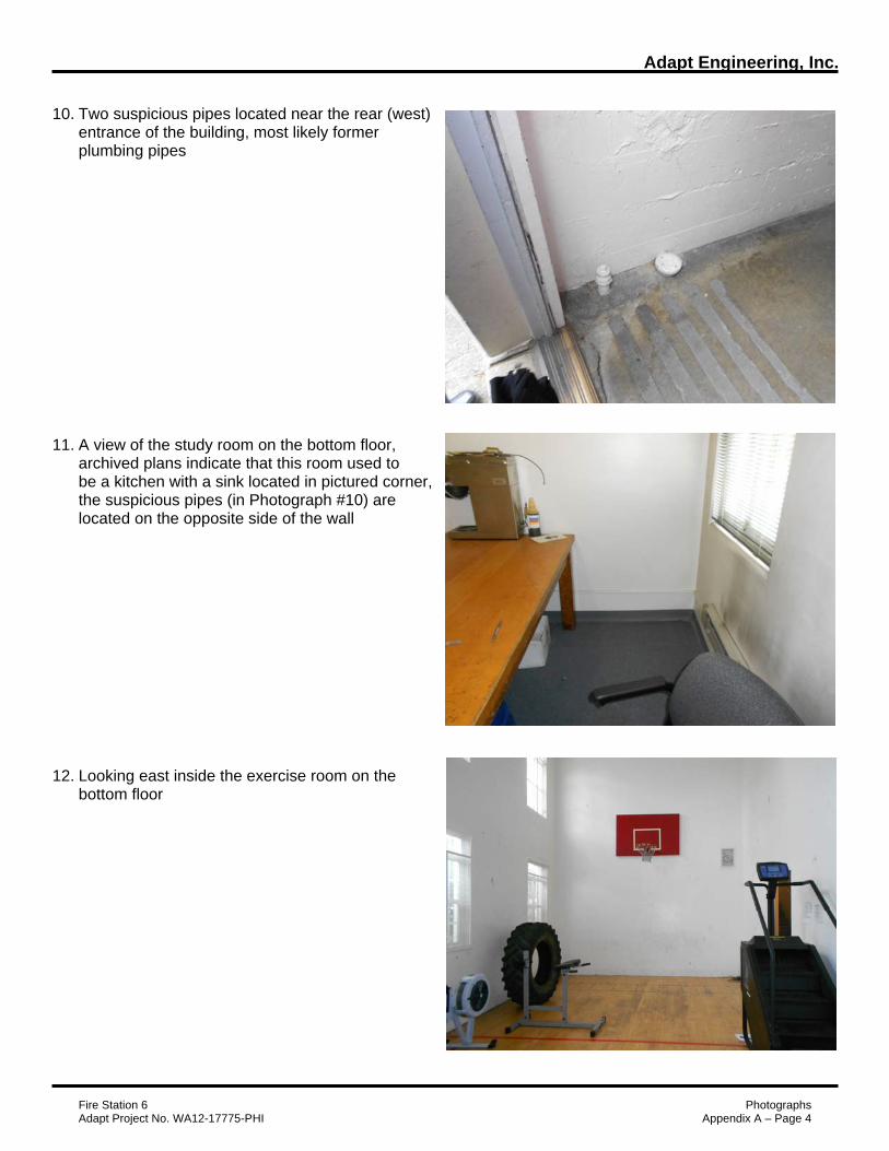
Adapt Engineering, Inc.
Fire Station 6 Photographs Adapt Project No. WA12-17775-PHI Appendix A – Page 4
10. Two suspicious pipes located near the rear (west) entrance of the building, most likely former plumbing pipes 11. A view of the study room on the bottom floor, archived plans indicate that this room used to be a kitchen with a sink located in pictured corner, the suspicious pipes (in Photograph #10) are located on the opposite side of the wall 12. Looking east inside the exercise room on the bottom floor

Adapt Engineering, Inc.
Fire Station 6 Photographs Adapt Project No. WA12-17775-PHI Appendix A – Page 5
13. Looking west at the backup generator in the bottom floor of the subject site, the fill port cap can be seen near the base with the words “Diesel Only” written on it 14. Looking south at the backup generator 15. Looking northeast at the electrical panels on the bottom floor of the subject site
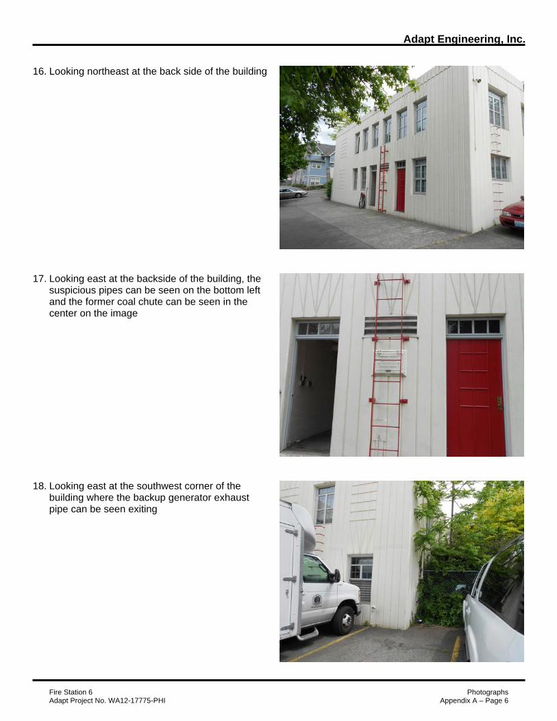
Adapt Engineering, Inc.
Fire Station 6 Photographs Adapt Project No. WA12-17775-PHI Appendix A – Page 6
16. Looking northeast at the back side of the building
17. Looking east at the backside of the building, the suspicious pipes can be seen on the bottom left and the former coal chute can be seen in the center on the image 18. Looking east at the southwest corner of the building where the backup generator exhaust pipe can be seen exiting

Adapt Engineering, Inc.
Fire Station 6 Photographs Adapt Project No. WA12-17775-PHI Appendix A – Page 7
19. Looking southeast at the south adjoining property
20. Looking south into the back yards of the west adjoining properties 21. Looking west along E Yesler Way

Adapt Engineering, Inc.
Fire Station 6 Photographs Adapt Project No. WA12-17775-PHI Appendix A – Page 8
22. Looking northeast across the intersection of 23rd Ave S and E Yesler Way at the Douglass- Truth Library
23. Looking east across 23rd Ave S at the Catholic Community Services Center 24. Looking south along 23rd Ave S

Adapt Engineering, Inc.
Fire Station 6 Photographs Adapt Project No. WA12-17775-PHI Appendix A – Page 9
25. Looking north across E Yesler Way at the Yesler Houses
Adapt Engineering, Inc.
Fire Station No. 6 June 14, 2012 Adapt Project No. WA12-17775-PH1 Appendix B - User Questionnaire
APPENDIX B
ASTM E1527-05 USER QUESTIONNAIRE


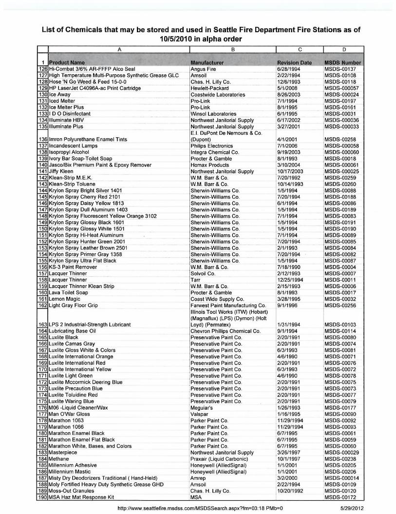

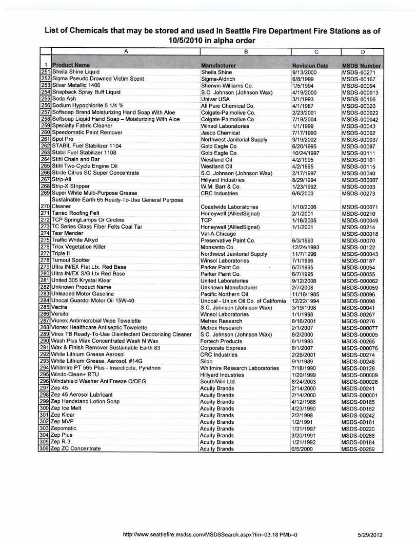
Adapt Engineering, Inc.
Fire Station No. 6 June 14, 2012 Adapt Project No. WA12-17775-PH1 Appendix C - EDR Radius Report
APPENDIX C
EDR RADIUS MAP REPORT

FORM-NULL-TXV
tropeR ™paM suidaR RDE ehT
440 Wheelers Farms RoadMilford, CT 06461Toll Free: 800.352.0050www.edrnet.com
Fire Station 6101 23rd Avenue SouthSeattle, WA 98144
Inquiry Number: 3322852.1sMay 14, 2012
SECTION PAGE
Executive Summary ES1
Overview Map 2
Detail Map 3
Map Findings Summary 4
Map Findings 7
Orphan Summary 322
Government Records Searched/Data Currency Tracking GR-1
GEOCHECK ADDENDUM
GeoCheck - Not Requested
TC3322852.1s Page 1
Thank you for your business.Please contact EDR at 1-800-352-0050
with any questions or comments.
Disclaimer - Copyright and Trademark Notice
This Report contains certain information obtained from a variety of public and other sources reasonably available to Environmental DataResources, Inc. It cannot be concluded from this Report that coverage information for the target and surrounding properties does not exist fromother sources. NO WARRANTY EXPRESSED OR IMPLIED, IS MADE WHATSOEVER IN CONNECTION WITH THIS REPORT. ENVIRONMENTALDATA RESOURCES, INC. SPECIFICALLY DISCLAIMS THE MAKING OF ANY SUCH WARRANTIES, INCLUDING WITHOUT LIMITATION,MERCHANTABILITY OR FITNESS FOR A PARTICULAR USE OR PURPOSE. ALL RISK IS ASSUMED BY THE USER. IN NO EVENT SHALLENVIRONMENTAL DATA RESOURCES, INC. BE LIABLE TO ANYONE, WHETHER ARISING OUT OF ERRORS OR OMISSIONS, NEGLIGENCE,ACCIDENT OR ANY OTHER CAUSE, FOR ANY LOSS OF DAMAGE, INCLUDING, WITHOUT LIMITATION, SPECIAL, INCIDENTAL,CONSEQUENTIAL, OR EXEMPLARY DAMAGES. ANY LIABILITY ON THE PART OF ENVIRONMENTAL DATA RESOURCES, INC. IS STRICTLYLIMITED TO A REFUND OF THE AMOUNT PAID FOR THIS REPORT. Purchaser accepts this Report "AS IS". Any analyses, estimates, ratings,environmental risk levels or risk codes provided in this Report are provided for illustrative purposes only, and are not intended to provide, norshould they be interpreted as providing any facts regarding, or prediction or forecast of, any environmental risk for any property. Only a Phase IEnvironmental Site Assessment performed by an environmental professional can provide information regarding the environmental risk for anyproperty. Additionally, the information provided in this Report is not to be construed as legal advice.
Copyright 2012 by Environmental Data Resources, Inc. All rights reserved. Reproduction in any media or format, in wholeor in part, of any report or map of Environmental Data Resources, Inc., or its affiliates, is prohibited without prior written permission.
EDR and its logos (including Sanborn and Sanborn Map) are trademarks of Environmental Data Resources, Inc. or its affiliates. All othertrademarks used herein are the property of their respective owners.
TABLE OF CONTENTS

EXECUTIVE SUMMARY
TC3322852.1s EXECUTIVE SUMMARY 1
A search of available environmental records was conducted by Environmental Data Resources, Inc (EDR).The report was designed to assist parties seeking to meet the search requirements of EPA’s Standardsand Practices for All Appropriate Inquiries (40 CFR Part 312), the ASTM Standard Practice forEnvironmental Site Assessments (E 1527-05) or custom requirements developed for the evaluation ofenvironmental risk associated with a parcel of real estate.
TARGET PROPERTY INFORMATION
ADDRESS
101 23RD AVENUE SOUTHSEATTLE, WA 98144
COORDINATES
47.6014000 - 47˚ 36’ 5.04’’Latitude (North): 122.3027000 - 122˚ 18’ 9.72’’Longitude (West): Zone 10Universal Tranverse Mercator: 552416.4UTM X (Meters): 5272016.0UTM Y (Meters): 307 ft. above sea levelElevation:
USGS TOPOGRAPHIC MAP ASSOCIATED WITH TARGET PROPERTY
47122-E3 SEATTLE SOUTH, WATarget Property Map:1983Most Recent Revision:
AERIAL PHOTOGRAPHY IN THIS REPORT
2009Photo Year:USDASource:
TARGET PROPERTY SEARCH RESULTS
The target property was identified in the following records. For more information on thisproperty see page 7 of the attached EDR Radius Map report:
EPA IDDatabase(s)Site
SEATTLE FIRE STATION 6101 23RD AVE SSEATTLE, WA 98144
N/ACSCSLALLSITESLUSTUST
SEATTLE FIRE STATION 6101 23RD AVE SSEATTLE, WA 98144
N/AFINDS
SEATTLE FIRE STATION 6101 23RD AVE. S.SEATTLE, WA 98144
N/AICR

EXECUTIVE SUMMARY
TC3322852.1s EXECUTIVE SUMMARY 2
DATABASES WITH NO MAPPED SITES
No mapped sites were found in EDR’s search of available ("reasonably ascertainable ") governmentrecords either on the target property or within the search radius around the target property for thefollowing databases:
STANDARD ENVIRONMENTAL RECORDS
Federal NPL site list
NPL National Priority ListProposed NPL Proposed National Priority List SitesNPL LIENS Federal Superfund Liens
Federal Delisted NPL site list
Delisted NPL National Priority List Deletions
Federal CERCLIS list
CERCLIS Comprehensive Environmental Response, Compensation, and Liability Information SystemFEDERAL FACILITY Federal Facility Site Information listing
Federal CERCLIS NFRAP site List
CERC-NFRAP CERCLIS No Further Remedial Action Planned
Federal RCRA CORRACTS facilities list
CORRACTS Corrective Action Report
Federal RCRA non-CORRACTS TSD facilities list
RCRA-TSDF RCRA - Treatment, Storage and Disposal
Federal RCRA generators list
RCRA-LQG RCRA - Large Quantity GeneratorsRCRA-SQG RCRA - Small Quantity Generators
Federal institutional controls / engineering controls registries
US ENG CONTROLS Engineering Controls Sites ListUS INST CONTROL Sites with Institutional Controls
Federal ERNS list
ERNS Emergency Response Notification System
State and tribal landfill and/or solid waste disposal site lists
SWF/LF Solid Waste Facility Database
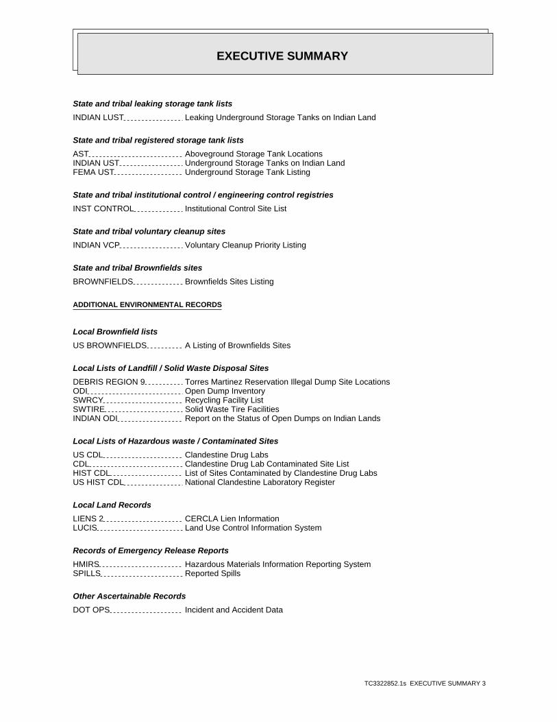
EXECUTIVE SUMMARY
TC3322852.1s EXECUTIVE SUMMARY 3
State and tribal leaking storage tank lists
INDIAN LUST Leaking Underground Storage Tanks on Indian Land
State and tribal registered storage tank lists
AST Aboveground Storage Tank LocationsINDIAN UST Underground Storage Tanks on Indian LandFEMA UST Underground Storage Tank Listing
State and tribal institutional control / engineering control registries
INST CONTROL Institutional Control Site List
State and tribal voluntary cleanup sites
INDIAN VCP Voluntary Cleanup Priority Listing
State and tribal Brownfields sites
BROWNFIELDS Brownfields Sites Listing
ADDITIONAL ENVIRONMENTAL RECORDS
Local Brownfield lists
US BROWNFIELDS A Listing of Brownfields Sites
Local Lists of Landfill / Solid Waste Disposal Sites
DEBRIS REGION 9 Torres Martinez Reservation Illegal Dump Site LocationsODI Open Dump InventorySWRCY Recycling Facility ListSWTIRE Solid Waste Tire FacilitiesINDIAN ODI Report on the Status of Open Dumps on Indian Lands
Local Lists of Hazardous waste / Contaminated Sites
US CDL Clandestine Drug LabsCDL Clandestine Drug Lab Contaminated Site ListHIST CDL List of Sites Contaminated by Clandestine Drug LabsUS HIST CDL National Clandestine Laboratory Register
Local Land Records
LIENS 2 CERCLA Lien InformationLUCIS Land Use Control Information System
Records of Emergency Release Reports
HMIRS Hazardous Materials Information Reporting SystemSPILLS Reported Spills
Other Ascertainable Records
DOT OPS Incident and Accident Data
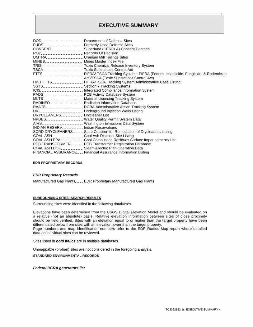
EXECUTIVE SUMMARY
TC3322852.1s EXECUTIVE SUMMARY 4
DOD Department of Defense SitesFUDS Formerly Used Defense SitesCONSENT Superfund (CERCLA) Consent DecreesROD Records Of DecisionUMTRA Uranium Mill Tailings SitesMINES Mines Master Index FileTRIS Toxic Chemical Release Inventory SystemTSCA Toxic Substances Control ActFTTS FIFRA/ TSCA Tracking System - FIFRA (Federal Insecticide, Fungicide, & Rodenticide Act)/TSCA (Toxic Substances Control Act)HIST FTTS FIFRA/TSCA Tracking System Administrative Case ListingSSTS Section 7 Tracking SystemsICIS Integrated Compliance Information SystemPADS PCB Activity Database SystemMLTS Material Licensing Tracking SystemRADINFO Radiation Information DatabaseRAATS RCRA Administrative Action Tracking SystemUIC Underground Injection Wells ListingDRYCLEANERS Drycleaner ListNPDES Water Quality Permit System DataAIRS Washington Emissions Data SystemINDIAN RESERV Indian ReservationsSCRD DRYCLEANERS State Coalition for Remediation of Drycleaners ListingCOAL ASH Coal Ash Disposal Site ListingCOAL ASH EPA Coal Combustion Residues Surface Impoundments ListPCB TRANSFORMER PCB Transformer Registration DatabaseCOAL ASH DOE Sleam-Electric Plan Operation DataFINANCIAL ASSURANCE Financial Assurance Information Listing
EDR PROPRIETARY RECORDS
EDR Proprietary Records
Manufactured Gas Plants EDR Proprietary Manufactured Gas Plants
SURROUNDING SITES: SEARCH RESULTS
Surrounding sites were identified in the following databases.
Elevations have been determined from the USGS Digital Elevation Model and should be evaluated ona relative (not an absolute) basis. Relative elevation information between sites of close proximityshould be field verified. Sites with an elevation equal to or higher than the target property have beendifferentiated below from sites with an elevation lower than the target property.Page numbers and map identification numbers refer to the EDR Radius Map report where detaileddata on individual sites can be reviewed.
Sites listed in bold italics are in multiple databases.
Unmappable (orphan) sites are not considered in the foregoing analysis.
STANDARD ENVIRONMENTAL RECORDS
Federal RCRA generators list

EXECUTIVE SUMMARY
TC3322852.1s EXECUTIVE SUMMARY 5
RCRA-CESQG: RCRAInfo is EPA’s comprehensive information system, providing access to data supportingthe Resource Conservation and Recovery Act (RCRA) of 1976 and the Hazardous and Solid Waste Amendments (HSWA)of 1984. The database includes selective information on sites which generate, transport, store, treat and/ordispose of hazardous waste as defined by the Resource Conservation and Recovery Act (RCRA). Conditionallyexempt small quantity generators (CESQGs) generate less than 100 kg of hazardous waste, or less than 1 kg ofacutely hazardous waste per month.
A review of the RCRA-CESQG list, as provided by EDR, and dated 11/10/2011 has revealed that there is 1 RCRA-CESQG site within approximately 0.25 miles of the target property.
PageMap IDDirection / Distance Address Lower Elevation ____________________ ________ ___________________ _____ _____
SEATTLE VOCATIONAL INSTITUTE 2120 S JACKSON ST SSW 1/8 - 1/4 (0.158 mi.) J33 29
State- and tribal - equivalent NPL
HSL: The Hazardous Sites List is a subset of the CSCSL Report. It includes sites which havebeen assessed and ranked using the Washington Ranking Method (WARM).
A review of the HSL list, as provided by EDR, and dated 02/28/2012 has revealed that there are 7 HSL sites within approximately 1 mile of the target property.
PageMap IDDirection / Distance Address Lower Elevation ____________________ ________ ___________________ _____ _____
DEARBORN CORPORATION CAMPUS GO WSW 1/2 - 1 (0.616 mi.) 84 164Facility Type: Hazardous Sites List
TD AUTO BODY & REPAIR 1209 E FIR ST W 1/2 - 1 (0.654 mi.) W88 171Facility Type: Hazardous Sites List
METAL LAUNDRY INCORPORATED 614 12TH WNW 1/2 - 1 (0.787 mi.) 94 192Facility Type: Hazardous Sites List
SEATTLE TECHNICAL FINISHING IN 1005 S KING WSW 1/2 - 1 (0.813 mi.) 98 223Facility Type: Hazardous Sites List
RALPHS CONCRETE PUMPING VACANT 1517 RANIER AVE S SSW 1/2 - 1 (0.861 mi.) X101 235Facility Type: Hazardous Sites List
RALPHS CONCRETE PUMPING 1511 RAINIER AVE S SSW 1/2 - 1 (0.870 mi.) X102 237Facility Type: Hazardous Sites List
KING CNTY DOT METRO TRANSIT DI 802 S DEARBORN ST WSW 1/2 - 1 (0.998 mi.) Y117 319Facility Type: Hazardous Sites List
State- and tribal - equivalent CERCLIS
CSCSL: The State Hazardous Waste Sites records are the states’ equivalent to CERCLIS. These sitesmay or may not already be listed on the federal CERCLIS list. Priority sites planned for cleanup using statefunds (state equivalent of Superfund) are identified along with sites where cleanup will be paid for bypotentially responsible parties. The data come from the Department of Ecology’s Confirmed & SuspectedContaminated Sites List.
A review of the CSCSL list, as provided by EDR, and dated 01/24/2012 has revealed that there are 43 CSCSL sites within approximately 1 mile of the target property.
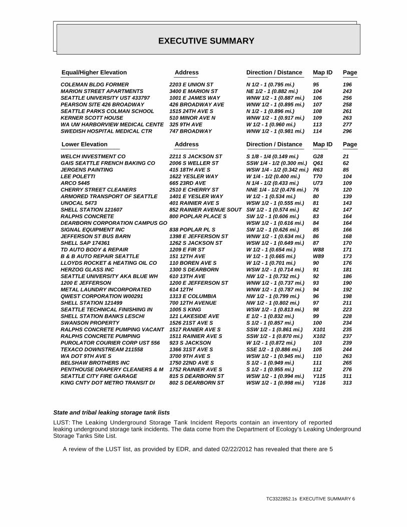
EXECUTIVE SUMMARY
TC3322852.1s EXECUTIVE SUMMARY 6
PageMap IDDirection / Distance Address Equal/Higher Elevation ____________________ ________ ___________________ _____ _____
COLEMAN BLDG FORMER 2203 E UNION ST N 1/2 - 1 (0.795 mi.) 95 196 MARION STREET APARTMENTS 3400 E MARION ST NE 1/2 - 1 (0.882 mi.) 104 243 SEATTLE UNIVERSITY UST 433797 1001 E JAMES WAY WNW 1/2 - 1 (0.887 mi.) 106 256 PEARSON SITE 426 BROADWAY 426 BROADWAY AVE WNW 1/2 - 1 (0.895 mi.) 107 258 SEATTLE PARKS COLMAN SCHOOL 1515 24TH AVE S N 1/2 - 1 (0.896 mi.) 108 261 KERNER SCOTT HOUSE 510 MINOR AVE N WNW 1/2 - 1 (0.917 mi.) 109 263 WA UW HARBORVIEW MEDICAL CENTE 325 9TH AVE W 1/2 - 1 (0.960 mi.) 113 277 SWEDISH HOSPITAL MEDICAL CTR 747 BROADWAY WNW 1/2 - 1 (0.981 mi.) 114 296
PageMap IDDirection / Distance Address Lower Elevation ____________________ ________ ___________________ _____ _____
WELCH INVESTMENT CO 2211 S JACKSON ST S 1/8 - 1/4 (0.149 mi.) G28 21 GAIS SEATTLE FRENCH BAKING CO 2006 S WELLER ST SSW 1/4 - 1/2 (0.300 mi.) Q61 62 JERGENS PAINTING 415 18TH AVE S WSW 1/4 - 1/2 (0.342 mi.) R63 85 LEE POLETTI 1622 YESLER WAY W 1/4 - 1/2 (0.400 mi.) T70 104 ARCO 5445 665 23RD AVE N 1/4 - 1/2 (0.433 mi.) U73 109 CHERRY STREET CLEANERS 2510 E CHERRY ST NNE 1/4 - 1/2 (0.476 mi.) 76 120 ARMORED TRANSPORT OF SEATTLE 1401 E YESLER WAY W 1/2 - 1 (0.534 mi.) 80 139 UNOCAL 5473 401 RAINIER AVE S WSW 1/2 - 1 (0.555 mi.) 81 143 SHELL STATION 121607 852 RAINIER AVENUE SOUT SW 1/2 - 1 (0.574 mi.) 82 147 RALPHS CONCRETE 800 POPLAR PLACE S SW 1/2 - 1 (0.606 mi.) 83 164 DEARBORN CORPORATION CAMPUS GO WSW 1/2 - 1 (0.616 mi.) 84 164 SIGNAL EQUIPMENT INC 838 POPLAR PL S SW 1/2 - 1 (0.626 mi.) 85 166 JEFFERSON ST BUS BARN 1398 E JEFFERSON ST WNW 1/2 - 1 (0.634 mi.) 86 168 SHELL SAP 174361 1262 S JACKSON ST WSW 1/2 - 1 (0.649 mi.) 87 170 TD AUTO BODY & REPAIR 1209 E FIR ST W 1/2 - 1 (0.654 mi.) W88 171 B & B AUTO REPAIR SEATTLE 151 12TH AVE W 1/2 - 1 (0.665 mi.) W89 173 LLOYDS ROCKET & HEATING OIL CO 110 BOREN AVE S W 1/2 - 1 (0.701 mi.) 90 176 HERZOG GLASS INC 1300 S DEARBORN WSW 1/2 - 1 (0.714 mi.) 91 181 SEATTLE UNIVERSITY AKA BLUE WH 610 13TH AVE NW 1/2 - 1 (0.732 mi.) 92 186 1200 E JEFFERSON 1200 E JEFFERSON ST WNW 1/2 - 1 (0.737 mi.) 93 190 METAL LAUNDRY INCORPORATED 614 12TH WNW 1/2 - 1 (0.787 mi.) 94 192 QWEST CORPORATION W00291 1313 E COLUMBIA NW 1/2 - 1 (0.799 mi.) 96 198 SHELL STATION 121499 700 12TH AVENUE NW 1/2 - 1 (0.802 mi.) 97 211 SEATTLE TECHNICAL FINISHING IN 1005 S KING WSW 1/2 - 1 (0.813 mi.) 98 223 SHELL STATION BANKS LESCHI 121 LAKESIDE AVE E 1/2 - 1 (0.832 mi.) 99 228 SWANSON PROPERTY 1526 21ST AVE S S 1/2 - 1 (0.857 mi.) 100 234 RALPHS CONCRETE PUMPING VACANT 1517 RANIER AVE S SSW 1/2 - 1 (0.861 mi.) X101 235 RALPHS CONCRETE PUMPING 1511 RAINIER AVE S SSW 1/2 - 1 (0.870 mi.) X102 237 PUROLATOR COURIER CORP UST 556 923 S JACKSON W 1/2 - 1 (0.872 mi.) 103 239 TEXACO DOWNSTREAM 211558 1366 31ST AVE S SSE 1/2 - 1 (0.886 mi.) 105 244 WA DOT 9TH AVE S 3700 9TH AVE S WSW 1/2 - 1 (0.945 mi.) 110 263 BELSHAW BROTHERS INC 1750 22ND AVE S S 1/2 - 1 (0.949 mi.) 111 265 PENTHOUSE DRAPERY CLEANERS & M 1752 RAINIER AVE S S 1/2 - 1 (0.955 mi.) 112 276 SEATTLE CITY FIRE GARAGE 815 S DEARBORN ST WSW 1/2 - 1 (0.994 mi.) Y115 311 KING CNTY DOT METRO TRANSIT DI 802 S DEARBORN ST WSW 1/2 - 1 (0.998 mi.) Y116 313
State and tribal leaking storage tank lists
LUST: The Leaking Underground Storage Tank Incident Reports contain an inventory of reportedleaking underground storage tank incidents. The data come from the Department of Ecology’s Leaking UndergroundStorage Tanks Site List.
A review of the LUST list, as provided by EDR, and dated 02/22/2012 has revealed that there are 5

EXECUTIVE SUMMARY
TC3322852.1s EXECUTIVE SUMMARY 7
LUST sites within approximately 0.5 miles of the target property.
PageMap IDDirection / Distance Address Lower Elevation ____________________ ________ ___________________ _____ _____
WELCH INVESTMENT CO 2211 S JACKSON ST S 1/8 - 1/4 (0.149 mi.) G28 21 GAIS SEATTLE FRENCH BAKING CO 2006 S WELLER ST SSW 1/4 - 1/2 (0.300 mi.) Q61 62 JERGENS PAINTING 415 18TH AVE S WSW 1/4 - 1/2 (0.342 mi.) R63 85 LEE POLETTI 1622 YESLER WAY W 1/4 - 1/2 (0.400 mi.) T70 104 ARCO 5445 665 23RD AVE N 1/4 - 1/2 (0.433 mi.) U74 116
State and tribal registered storage tank lists
UST: The Underground Storage Tank database contains registered USTs. USTs are regulated underSubtitle I of the Resource Conservation and Recovery Act (RCRA). The data come from the Department ofEcology’s Statewide UST Site/Tank Report.
A review of the UST list, as provided by EDR, and dated 02/24/2012 has revealed that there are 5 UST sites within approximately 0.25 miles of the target property.
PageMap IDDirection / Distance Address Lower Elevation ____________________ ________ ___________________ _____ _____
NEW HOPE BAPTIST CHURCH 120 21 ST AVE WNW 0 - 1/8 (0.118 mi.) 23 14 WELCH INVESTMENT CO 2211 S JACKSON ST S 1/8 - 1/4 (0.149 mi.) G28 21 23RD & JACKSON SITE 23RD & S JACKSON SE 1/8 - 1/4 (0.170 mi.) K38 35 GARFIELD RECREATION CENTER 500 23RD AVE E S 1/8 - 1/4 (0.247 mi.) 51 39 EVERGREEN ELECTRICAL CONTRACTO 2615 S JACKSON ST SE 1/8 - 1/4 (0.248 mi.) M53 41
State and tribal voluntary cleanup sites
VCP: Sites that have entered either the Voluntary Cleanup Program or its predecessorIndependent Remedial Action Program.
A review of the VCP list, as provided by EDR, and dated 01/24/2012 has revealed that there are 5 VCP sites within approximately 0.5 miles of the target property.
PageMap IDDirection / Distance Address Equal/Higher Elevation ____________________ ________ ___________________ _____ _____
CITY VIEW ASSOCIATES LLC 2901 S JACKSON ST ESE 1/4 - 1/2 (0.391 mi.) S69 103 SWEDISH MEDICAL CENTER PROVIDE 500 17TH AVE NW 1/4 - 1/2 (0.483 mi.) V79 126
PageMap IDDirection / Distance Address Lower Elevation ____________________ ________ ___________________ _____ _____
INTERSTATE BRANDS CORP WONDER 1805 S MAIN WSW 1/4 - 1/2 (0.281 mi.) P58 56 ARCO 5445 665 23RD AVE N 1/4 - 1/2 (0.433 mi.) U73 109 CHERRY STREET CLEANERS 2510 E CHERRY ST NNE 1/4 - 1/2 (0.476 mi.) 76 120
ICR: These are remedial action reports Ecology has received from either the owner or operatorof the site. These actions have been conducted without department oversight or approval and are not under anorder or decree.
A review of the ICR list, as provided by EDR, and dated 12/01/2002 has revealed that there are 4 ICR

EXECUTIVE SUMMARY
TC3322852.1s EXECUTIVE SUMMARY 8
sites within approximately 0.5 miles of the target property.
PageMap IDDirection / Distance Address Equal/Higher Elevation ____________________ ________ ___________________ _____ _____
CITY VIEW ASSOCIATES LLC 2901 S JACKSON ST ESE 1/4 - 1/2 (0.391 mi.) S68 100 PROVIDENCE HOSPITAL 500 17TH AVE. NW 1/4 - 1/2 (0.483 mi.) V77 125
PageMap IDDirection / Distance Address Lower Elevation ____________________ ________ ___________________ _____ _____
GAI’S BAKERY 2006 S. WELLER SSW 1/4 - 1/2 (0.300 mi.) Q60 62 LAKESHORE INVESTMENT CORP./STR 1622 E. YESLER WAY W 1/4 - 1/2 (0.400 mi.) T71 107
ADDITIONAL ENVIRONMENTAL RECORDS
Local Lists of Hazardous waste / Contaminated Sites
ALLSITES: Information on facilities and sites of interest to the Department of Ecology.
A review of the ALLSITES list, as provided by EDR, and dated 01/31/2012 has revealed that there are 30 ALLSITES sites within approximately 0.5 miles of the target property.
PageMap IDDirection / Distance Address Equal/Higher Elevation ____________________ ________ ___________________ _____ _____
SPHERE SOLID WASTE INC 2821 S JACKSON ESE 1/4 - 1/2 (0.367 mi.) 65 94 CITY VIEW ASSOCIATES LLC 2901 S JACKSON ST ESE 1/4 - 1/2 (0.391 mi.) S69 103 HOPE HEART INSTITUTE THE 500 17TH AVE RM 475D NW 1/4 - 1/2 (0.483 mi.) V78 125 SWEDISH MEDICAL CENTER PROVIDE 500 17TH AVE NW 1/4 - 1/2 (0.483 mi.) V79 126
PageMap IDDirection / Distance Address Lower Elevation ____________________ ________ ___________________ _____ _____
NEW HOPE BAPTIST CHURCH 120 21 ST AVE WNW 0 - 1/8 (0.118 mi.) 23 14 SNAPPY CLEANERS 2204 S JACKSON ST S 1/8 - 1/4 (0.147 mi.) G25 16 PROMENADE 23 2302 S JACKSON ST S 1/8 - 1/4 (0.147 mi.) H27 20 WELCH INVESTMENT CO 2211 S JACKSON ST S 1/8 - 1/4 (0.149 mi.) G28 21 JACKSON CLEANERS 2301 S JACKSON ST S 1/8 - 1/4 (0.149 mi.) H29 24 SEATTLE VOCATIONAL INSTITUTE 2120 S JACKSON ST SSW 1/8 - 1/4 (0.158 mi.) J33 29 23RD & JACKSON SITE 23RD & S JACKSON SE 1/8 - 1/4 (0.170 mi.) K38 35 GARFIELD RECREATION CENTER 500 23RD AVE E S 1/8 - 1/4 (0.247 mi.) 51 39 EVERGREEN ELECTRICAL CONTRACTO 2615 S JACKSON ST SE 1/8 - 1/4 (0.248 mi.) M53 41 SEATTLE SCHOOL DIST 1 GARFIELD 400 23RD AVE N 1/4 - 1/2 (0.258 mi.) N54 43 CONTINENTAL BAKING CO SEATTLE 1924 S JACKSON ST SW 1/4 - 1/2 (0.261 mi.) O55 54 NORTH STAR ELECTRIC 1905 S JACKSON ST WSW 1/4 - 1/2 (0.272 mi.) O56 55 SEATTLE CITY PARKS & REC 428 23RD AVE N 1/4 - 1/2 (0.278 mi.) N57 55 INTERSTATE BRANDS CORP WONDER 1805 S MAIN WSW 1/4 - 1/2 (0.281 mi.) P58 56 1800 S JACKSON ST THE MARK 1800 S JACKSON ST WSW 1/4 - 1/2 (0.282 mi.) P59 61 GAIS SEATTLE FRENCH BAKING CO 2006 S WELLER ST SSW 1/4 - 1/2 (0.300 mi.) Q61 62 SEATTLE COMM COLLEGE WOOD CONS 2310 S LN ST S 1/4 - 1/2 (0.320 mi.) 62 79 JERGENS PAINTING 415 18TH AVE S WSW 1/4 - 1/2 (0.342 mi.) R63 85 LC JERGENS PAINTING CO 417 18TH AVE S WSW 1/4 - 1/2 (0.344 mi.) R64 92 AMERICAN BUILDING MAINTENANCE 1711 S JACKSON ST WSW 1/4 - 1/2 (0.377 mi.) 66 95 TRUCK CENTER CORPORATION 600 22 S 5TH N 1/4 - 1/2 (0.386 mi.) 67 99 LEE POLETTI 1622 YESLER WAY W 1/4 - 1/2 (0.400 mi.) T70 104 AMTECH LIGHTING SERVICES 1617 S JACKSON ST WSW 1/4 - 1/2 (0.431 mi.) 72 107 ARCO 5445 665 23RD AVE N 1/4 - 1/2 (0.433 mi.) U73 109 SEATTLE SCH DIST NOVA ALTERNAT 2410 E CHERRY ST N 1/4 - 1/2 (0.462 mi.) 75 118 CHERRY STREET CLEANERS 2510 E CHERRY ST NNE 1/4 - 1/2 (0.476 mi.) 76 120

EXECUTIVE SUMMARY
TC3322852.1s EXECUTIVE SUMMARY 9
CSCSL NFA: The data set contains information about sites previously on the Confirmed and SuspectedContaminated Sites list that have received a No Further Action (NFA) determination. Because it is necessary tomaintain historical records of sites that have been investigated and cleaned up, sites are not deleted fromthe database when cleanup activities are completed. Instead a No Further Action code is entered based upon thetype of NFA determination the site received.
A review of the CSCSL NFA list, as provided by EDR, and dated 01/24/2012 has revealed that there are 4 CSCSL NFA sites within approximately 0.5 miles of the target property.
PageMap IDDirection / Distance Address Equal/Higher Elevation ____________________ ________ ___________________ _____ _____
CITY VIEW ASSOCIATES LLC 2901 S JACKSON ST ESE 1/4 - 1/2 (0.391 mi.) S69 103 SWEDISH MEDICAL CENTER PROVIDE 500 17TH AVE NW 1/4 - 1/2 (0.483 mi.) V79 126
PageMap IDDirection / Distance Address Lower Elevation ____________________ ________ ___________________ _____ _____
23RD & JACKSON SITE 23RD & S JACKSON SE 1/8 - 1/4 (0.170 mi.) K38 35 INTERSTATE BRANDS CORP WONDER 1805 S MAIN WSW 1/4 - 1/2 (0.281 mi.) P58 56
Other Ascertainable Records
RCRA-NonGen: RCRAInfo is EPA’s comprehensive information system, providing access to data supportingthe Resource Conservation and Recovery Act (RCRA) of 1976 and the Hazardous and Solid Waste Amendments (HSWA)of 1984. The database includes selective information on sites which generate, transport, store, treat and/ordispose of hazardous waste as defined by the Resource Conservation and Recovery Act (RCRA). Non-Generators donot presently generate hazardous waste.
A review of the RCRA-NonGen list, as provided by EDR, and dated 11/10/2011 has revealed that there are 3 RCRA-NonGen sites within approximately 0.25 miles of the target property.
PageMap IDDirection / Distance Address Lower Elevation ____________________ ________ ___________________ _____ _____
SNAPPY CLEANERS 2204 S JACKSON ST S 1/8 - 1/4 (0.147 mi.) G25 16 PROMENADE 23 2302 S JACKSON ST S 1/8 - 1/4 (0.147 mi.) H27 20 JACKSON CLEANERS 2301 S JACKSON ST S 1/8 - 1/4 (0.149 mi.) H29 24
MANIFEST: Hazardous waste manifest information.
A review of the MANIFEST list, as provided by EDR, and dated 12/31/2010 has revealed that there is 1 MANIFEST site within approximately 0.25 miles of the target property.
PageMap IDDirection / Distance Address Lower Elevation ____________________ ________ ___________________ _____ _____
SEATTLE VOCATIONAL INSTITUTE 2120 S JACKSON ST SSW 1/8 - 1/4 (0.158 mi.) J33 29
Inactive Drycleaners: A listing of inactive drycleaner facility locations.
A review of the Inactive Drycleaners list, as provided by EDR, and dated 12/31/2010 has revealed that there are 2 Inactive Drycleaners sites within approximately 0.25 miles of the target property.
PageMap IDDirection / Distance Address Lower Elevation ____________________ ________ ___________________ _____ _____
SNAPPY CLEANERS 2204 S JACKSON ST S 1/8 - 1/4 (0.147 mi.) G25 16 JACKSON CLEANERS 2301 S JACKSON ST S 1/8 - 1/4 (0.149 mi.) H29 24

EXECUTIVE SUMMARY
TC3322852.1s EXECUTIVE SUMMARY 10
EDR PROPRIETARY RECORDS
EDR Proprietary Records
EDR Historical Auto Stations: EDR has searched selected national collections of business directories and has collectedlistings of potential gas station/filling station/service station sites that were available to EDRresearchers. EDR’s review was limited to those categories of sources that might, in EDR’s opinion, includegas station/filling station/service station establishments. The categories reviewed included, but were notlimited to gas, gas station, gasoline station, filling station, auto, automobile repair, auto service station,service station, etc.
A review of the EDR Historical Auto Stations list, as provided by EDR, has revealed that there are 25 EDR Historical Auto Stations sites within approximately 0.25 miles of the target property.
PageMap IDDirection / Distance Address Equal/Higher Elevation ____________________ ________ ___________________ _____ _____
CASTON J M 124 23D AVE NNE 0 - 1/8 (0.053 mi.) B4 9 KUBOTA BROS SERVICE STATION 124 23RD AVE NNE 0 - 1/8 (0.053 mi.) B5 10 CENTURY AUTO REBUILD 110 24TH AVE S E 0 - 1/8 (0.077 mi.) C6 10 FOU.RTEENTH AVENUE SERVICE 2401 YESLER WAY ENE 0 - 1/8 (0.078 mi.) C7 10 SWAN S AUTO REPAIR 2409 YESLER WAY ENE 0 - 1/8 (0.082 mi.) C11 11 SWAN S AUTO REPAIR 2409 E YESLER WAY ENE 0 - 1/8 (0.083 mi.) C12 12
PageMap IDDirection / Distance Address Lower Elevation ____________________ ________ ___________________ _____ _____
JIM S GULF SERVICE 320 23D AVE S SSE 0 - 1/8 (0.092 mi.) D14 12 PIERCE WM H 321 23D AVE S SSE 0 - 1/8 (0.092 mi.) D15 12 TRIANGLE REBUILDERS S PARTS 321 23RD AVE S SSE 0 - 1/8 (0.092 mi.) D16 13 JIM S GULF SERVICE 320 23RD AVE S SSE 0 - 1/8 (0.093 mi.) D17 13 ACME AUTO REBUILD 325 22D AVENUE S S SSW 0 - 1/8 (0.096 mi.) E18 13 ACME AUTO REBUILD 325 22D AVE S SSW 0 - 1/8 (0.096 mi.) E19 13 NW AVANTS AUTO REBUILD 325 22ND AVE S SSW 0 - 1/8 (0.097 mi.) E20 14 JONES SEVELITY SIX UNION STATI 2115 YESLER WAY W 0 - 1/8 (0.101 mi.) F21 14 JAMES UNION SERVICE STATION 2115 E YESLER WAY W 0 - 1/8 (0.101 mi.) F22 14 BROWN S SERVICE STATION 2116 S JACKSON ST SSW 1/8 - 1/4 (0.159 mi.) J34 34 CAPERS FLYING A SERVICE 2420 S JACKSON ST SSE 1/8 - 1/4 (0.168 mi.) K37 34 L AND P SIGNAIL SERVICE 2614 YESLER WAY E 1/8 - 1/4 (0.185 mi.) 39 36 KONO S AUTOMOTIVE SERVICE 2028 S JACKSON ST SW 1/8 - 1/4 (0.205 mi.) 40 36 BILL S TUNE UP CENTER AND BRAK 2524 S JACKSON ST SE 1/8 - 1/4 (0.207 mi.) 41 36 OZZIE AND SEAN ENTERPRISES 1902 E YESLER WAY W 1/8 - 1/4 (0.230 mi.) L46 38 ROY S FLYING A SERVICE STATION 1901 YESLER WAY W 1/8 - 1/4 (0.231 mi.) L47 38 CHICK AND TOMMY S CHEVRON SERV 1901 E YESLER WAY W 1/8 - 1/4 (0.232 mi.) L48 38 L P AUTOMOTIVE 2603 S JACKSON ST SE 1/8 - 1/4 (0.242 mi.) M50 39 CUTCH S TOUCH AND TUNE 2616 S JACKSON ST SE 1/8 - 1/4 (0.248 mi.) M52 40
EDR Historical Cleaners: EDR has searched selected national collections of business directories and has collectedlistings of potential dry cleaner sites that were available to EDR researchers. EDR’s review was limited tothose categories of sources that might, in EDR’s opinion, include dry cleaning establishments. The categoriesreviewed included, but were not limited to dry cleaners, cleaners, laundry, laundromat, cleaning/laundry, wash& dry etc.
A review of the EDR Historical Cleaners list, as provided by EDR, has revealed that there are 16 EDR Historical Cleaners sites within approximately 0.25 miles of the target property.

EXECUTIVE SUMMARY
TC3322852.1s EXECUTIVE SUMMARY 11
PageMap IDDirection / Distance Address Equal/Higher Elevation ____________________ ________ ___________________ _____ _____
E Z LAUNDERMAT 2405 YESLER WAY ENE 0 - 1/8 (0.080 mi.) C8 10 E Z LAUNDERMAT 2407 YESLER WAY ENE 0 - 1/8 (0.080 mi.) C9 11 E Z WASH 2405 E YESLER WAY ENE 0 - 1/8 (0.080 mi.) C10 11
PageMap IDDirection / Distance Address Lower Elevation ____________________ ________ ___________________ _____ _____
HALE DRY CLEANERS 212 24TH AVE S ESE 0 - 1/8 (0.086 mi.) 13 12 SNAPPY CLEANERS 2204 S JACKSON ST S 1/8 - 1/4 (0.147 mi.) G24 15 SNAPPY SELF SERVICE LAUNDRY 2202 S JACKSON ST S 1/8 - 1/4 (0.147 mi.) G26 19 KASAOKA TSUNETARO 403 23D AVE S S 1/8 - 1/4 (0.151 mi.) H30 28 DAY AND NITE LAUNDER CENTER 2023 E YESLER WAY W 1/8 - 1/4 (0.157 mi.) I31 28 EMPRESS DYE WORKS 2021 YESLER WAY W 1/8 - 1/4 (0.158 mi.) I32 28 PANAMA CLEANERS 2407 S JACKSON ST SSE 1/8 - 1/4 (0.165 mi.) K35 34 EBONY CLEANERS 2420 S JACKSON ST SSE 1/8 - 1/4 (0.168 mi.) K36 34 EAST MADISON VALET CLEANERS 1922 E YESLER WAY W 1/8 - 1/4 (0.212 mi.) L42 37 SWIFT CLEANERS 1920 E YESLER WAY W 1/8 - 1/4 (0.213 mi.) L43 37 JIM LEE HAND LAUNDRY 1925 YESLER WAY W 1/8 - 1/4 (0.217 mi.) L44 37 SWIFT CLEANERS 1920 YESLER WAY W 1/8 - 1/4 (0.220 mi.) L45 37 SPIC N SPAN CLEANERS NO 4 2600 S JACKSON ST SE 1/8 - 1/4 (0.240 mi.) M49 38
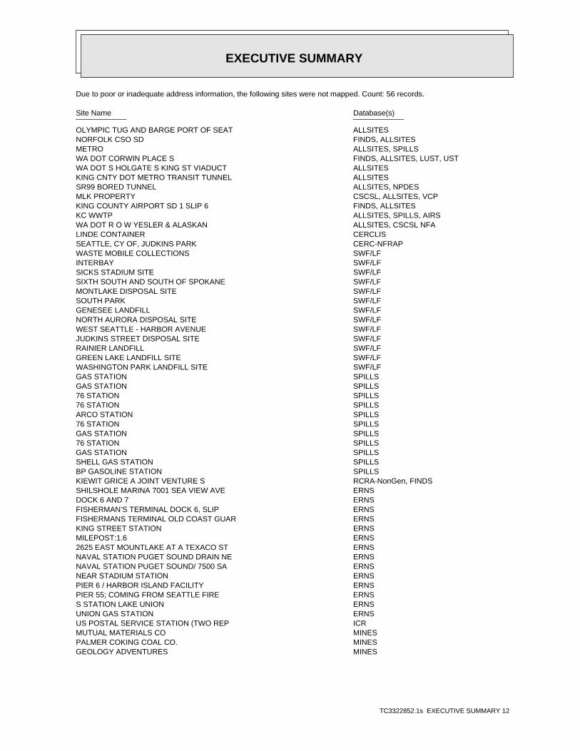
EXECUTIVE SUMMARY
TC3322852.1s EXECUTIVE SUMMARY 12
Due to poor or inadequate address information, the following sites were not mapped. Count: 56 records.
Site Name Database(s)____________ ____________
OLYMPIC TUG AND BARGE PORT OF SEAT ALLSITESNORFOLK CSO SD FINDS, ALLSITESMETRO ALLSITES, SPILLSWA DOT CORWIN PLACE S FINDS, ALLSITES, LUST, USTWA DOT S HOLGATE S KING ST VIADUCT ALLSITESKING CNTY DOT METRO TRANSIT TUNNEL ALLSITESSR99 BORED TUNNEL ALLSITES, NPDESMLK PROPERTY CSCSL, ALLSITES, VCPKING COUNTY AIRPORT SD 1 SLIP 6 FINDS, ALLSITESKC WWTP ALLSITES, SPILLS, AIRSWA DOT R O W YESLER & ALASKAN ALLSITES, CSCSL NFALINDE CONTAINER CERCLISSEATTLE, CY OF, JUDKINS PARK CERC-NFRAPWASTE MOBILE COLLECTIONS SWF/LFINTERBAY SWF/LFSICKS STADIUM SITE SWF/LFSIXTH SOUTH AND SOUTH OF SPOKANE SWF/LFMONTLAKE DISPOSAL SITE SWF/LFSOUTH PARK SWF/LFGENESEE LANDFILL SWF/LFNORTH AURORA DISPOSAL SITE SWF/LFWEST SEATTLE - HARBOR AVENUE SWF/LFJUDKINS STREET DISPOSAL SITE SWF/LFRAINIER LANDFILL SWF/LFGREEN LAKE LANDFILL SITE SWF/LFWASHINGTON PARK LANDFILL SITE SWF/LFGAS STATION SPILLSGAS STATION SPILLS76 STATION SPILLS76 STATION SPILLSARCO STATION SPILLS76 STATION SPILLSGAS STATION SPILLS76 STATION SPILLSGAS STATION SPILLSSHELL GAS STATION SPILLSBP GASOLINE STATION SPILLSKIEWIT GRICE A JOINT VENTURE S RCRA-NonGen, FINDSSHILSHOLE MARINA 7001 SEA VIEW AVE ERNSDOCK 6 AND 7 ERNSFISHERMAN’S TERMINAL DOCK 6, SLIP ERNSFISHERMANS TERMINAL OLD COAST GUAR ERNSKING STREET STATION ERNSMILEPOST:1.6 ERNS2625 EAST MOUNTLAKE AT A TEXACO ST ERNSNAVAL STATION PUGET SOUND DRAIN NE ERNSNAVAL STATION PUGET SOUND/ 7500 SA ERNSNEAR STADIUM STATION ERNSPIER 6 / HARBOR ISLAND FACILITY ERNSPIER 55; COMING FROM SEATTLE FIRE ERNSS STATION LAKE UNION ERNSUNION GAS STATION ERNSUS POSTAL SERVICE STATION (TWO REP ICRMUTUAL MATERIALS CO MINESPALMER COKING COAL CO. MINESGEOLOGY ADVENTURES MINES

EDR Inc.EDR Inc.EDR Inc.EDR Inc.EDR Inc.EDR Inc.EDR Inc.EDR Inc.EDR Inc.EDR Inc.EDR Inc.EDR Inc.EDR Inc.EDR Inc.EDR Inc.EDR Inc.EDR Inc.EDR Inc.EDR Inc.EDR Inc.EDR Inc.EDR Inc.EDR Inc.EDR Inc.EDR Inc.EDR Inc.EDR Inc.EDR Inc.EDR Inc.EDR Inc.EDR Inc.EDR Inc.EDR Inc.EDR Inc.EDR Inc.EDR Inc.EDR Inc.EDR Inc.EDR Inc.EDR Inc.
1111
115
kV
115
kV
11
115
kV
115
kV
115 kV
115 kV
115 kV
115 kV
36
0
36
0
3 20
32
0
20
0
20
0
320
32
0
32 0
28
0
28
0
28
0
20
020
0
20
0
32
0
32
0
32
0
32
0
28
0
280
28
0
28
0
28
0
28
0
28
0
20
0
20
0
2 0 0
2 0 0
2
0 0
32
0
2 0 0
20
0
24
0
24
0
24
0
24
0
24
0
24
0
2
4 0
2 0 0
20
02 0 0
20 0
1 6 0
16
0
1 6 0
16
0
16
0
16
0
1 2 0
1 20
12
0
12
0
12
0
12
0
12
28
0280
24
0
20
0
20
0
16
0
16
0
120
120
80
80
8
80
80
40
40
40
40

EDR Inc.EDR Inc.EDR Inc.EDR Inc.EDR Inc.EDR Inc.EDR Inc.EDR Inc.EDR Inc.EDR Inc.EDR Inc.EDR Inc.EDR Inc.EDR Inc.EDR Inc.EDR Inc.EDR Inc.EDR Inc.EDR Inc.EDR Inc.EDR Inc.EDR Inc.EDR Inc.EDR Inc.EDR Inc.EDR Inc.EDR Inc.EDR Inc.EDR Inc.EDR Inc.EDR Inc.EDR Inc.EDR Inc.EDR Inc.EDR Inc.EDR Inc.EDR Inc.EDR Inc.EDR Inc.EDR Inc.
320
280

MAP FINDINGS SUMMARY
SearchTargetDistance Total
Database Property(Miles) < 1/8 1/8 - 1/4 1/4 - 1/2 1/2 - 1 > 1 Plotted
STANDARD ENVIRONMENTAL RECORDS
Federal NPL site list
0 NR 0 0 0 0 1.000NPL 0 NR 0 0 0 0 1.000Proposed NPL 0 NR NR NR NR NR TPNPL LIENS
Federal Delisted NPL site list
0 NR 0 0 0 0 1.000Delisted NPL
Federal CERCLIS list
0 NR NR 0 0 0 0.500CERCLIS 0 NR 0 0 0 0 1.000FEDERAL FACILITY
Federal CERCLIS NFRAP site List
0 NR NR 0 0 0 0.500CERC-NFRAP
Federal RCRA CORRACTS facilities list
0 NR 0 0 0 0 1.000CORRACTS
Federal RCRA non-CORRACTS TSD facilities list
0 NR NR 0 0 0 0.500RCRA-TSDF
Federal RCRA generators list
0 NR NR NR 0 0 0.250RCRA-LQG 0 NR NR NR 0 0 0.250RCRA-SQG 1 NR NR NR 1 0 0.250RCRA-CESQG
Federal institutional controls /engineering controls registries
0 NR NR 0 0 0 0.500US ENG CONTROLS 0 NR NR 0 0 0 0.500US INST CONTROL
Federal ERNS list
0 NR NR NR NR NR TPERNS
State- and tribal - equivalent NPL
7 NR 7 0 0 0 1.000HSL
State- and tribal - equivalent CERCLIS
44 NR 37 5 1 0 1.000 1CSCSL
State and tribal landfill and/orsolid waste disposal site lists
0 NR NR 0 0 0 0.500SWF/LF
State and tribal leaking storage tank lists
6 NR NR 4 1 0 0.500 1LUST 0 NR NR 0 0 0 0.500INDIAN LUST
TC3322852.1s Page 4

MAP FINDINGS SUMMARY
SearchTargetDistance Total
Database Property(Miles) < 1/8 1/8 - 1/4 1/4 - 1/2 1/2 - 1 > 1 Plotted
State and tribal registered storage tank lists
6 NR NR NR 4 1 0.250 1UST 0 NR NR NR 0 0 0.250AST 0 NR NR NR 0 0 0.250INDIAN UST 0 NR NR NR 0 0 0.250FEMA UST
State and tribal institutionalcontrol / engineering control registries
0 NR NR 0 0 0 0.500INST CONTROL
State and tribal voluntary cleanup sites
5 NR NR 5 0 0 0.500VCP 5 NR NR 4 0 0 0.500 1ICR 0 NR NR 0 0 0 0.500INDIAN VCP
State and tribal Brownfields sites
0 NR NR 0 0 0 0.500BROWNFIELDS
ADDITIONAL ENVIRONMENTAL RECORDS
Local Brownfield lists
0 NR NR 0 0 0 0.500US BROWNFIELDS
Local Lists of Landfill / SolidWaste Disposal Sites
0 NR NR 0 0 0 0.500DEBRIS REGION 9 0 NR NR 0 0 0 0.500ODI 0 NR NR 0 0 0 0.500SWRCY 0 NR NR 0 0 0 0.500SWTIRE 0 NR NR 0 0 0 0.500INDIAN ODI
Local Lists of Hazardous waste /Contaminated Sites
0 NR NR NR NR NR TPUS CDL 31 NR NR 21 8 1 0.500 1ALLSITES 4 NR NR 3 1 0 0.500CSCSL NFA 0 NR NR NR NR NR TPCDL 0 NR NR NR NR NR TPHIST CDL 0 NR NR NR NR NR TPUS HIST CDL
Local Land Records
0 NR NR NR NR NR TPLIENS 2 0 NR NR 0 0 0 0.500LUCIS
Records of Emergency Release Reports
0 NR NR NR NR NR TPHMIRS 0 NR NR NR NR NR TPSPILLS
Other Ascertainable Records
3 NR NR NR 3 0 0.250RCRA-NonGen
TC3322852.1s Page 5
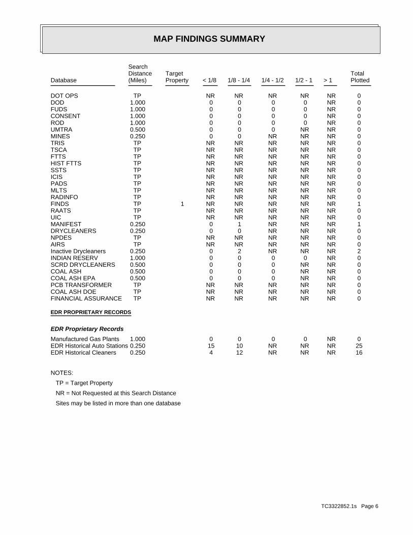
MAP FINDINGS SUMMARY
SearchTargetDistance Total
Database Property(Miles) < 1/8 1/8 - 1/4 1/4 - 1/2 1/2 - 1 > 1 Plotted
0 NR NR NR NR NR TPDOT OPS 0 NR 0 0 0 0 1.000DOD 0 NR 0 0 0 0 1.000FUDS 0 NR 0 0 0 0 1.000CONSENT 0 NR 0 0 0 0 1.000ROD 0 NR NR 0 0 0 0.500UMTRA 0 NR NR NR 0 0 0.250MINES 0 NR NR NR NR NR TPTRIS 0 NR NR NR NR NR TPTSCA 0 NR NR NR NR NR TPFTTS 0 NR NR NR NR NR TPHIST FTTS 0 NR NR NR NR NR TPSSTS 0 NR NR NR NR NR TPICIS 0 NR NR NR NR NR TPPADS 0 NR NR NR NR NR TPMLTS 0 NR NR NR NR NR TPRADINFO 1 NR NR NR NR NR TP 1FINDS 0 NR NR NR NR NR TPRAATS 0 NR NR NR NR NR TPUIC 1 NR NR NR 1 0 0.250MANIFEST 0 NR NR NR 0 0 0.250DRYCLEANERS 0 NR NR NR NR NR TPNPDES 0 NR NR NR NR NR TPAIRS 2 NR NR NR 2 0 0.250Inactive Drycleaners 0 NR 0 0 0 0 1.000INDIAN RESERV 0 NR NR 0 0 0 0.500SCRD DRYCLEANERS 0 NR NR 0 0 0 0.500COAL ASH 0 NR NR 0 0 0 0.500COAL ASH EPA 0 NR NR NR NR NR TPPCB TRANSFORMER 0 NR NR NR NR NR TPCOAL ASH DOE 0 NR NR NR NR NR TPFINANCIAL ASSURANCE
EDR PROPRIETARY RECORDS
EDR Proprietary Records
0 NR 0 0 0 0 1.000Manufactured Gas Plants 25 NR NR NR 10 15 0.250EDR Historical Auto Stations 16 NR NR NR 12 4 0.250EDR Historical Cleaners
NOTES:
TP = Target Property
NR = Not Requested at this Search Distance
Sites may be listed in more than one database
TC3322852.1s Page 6
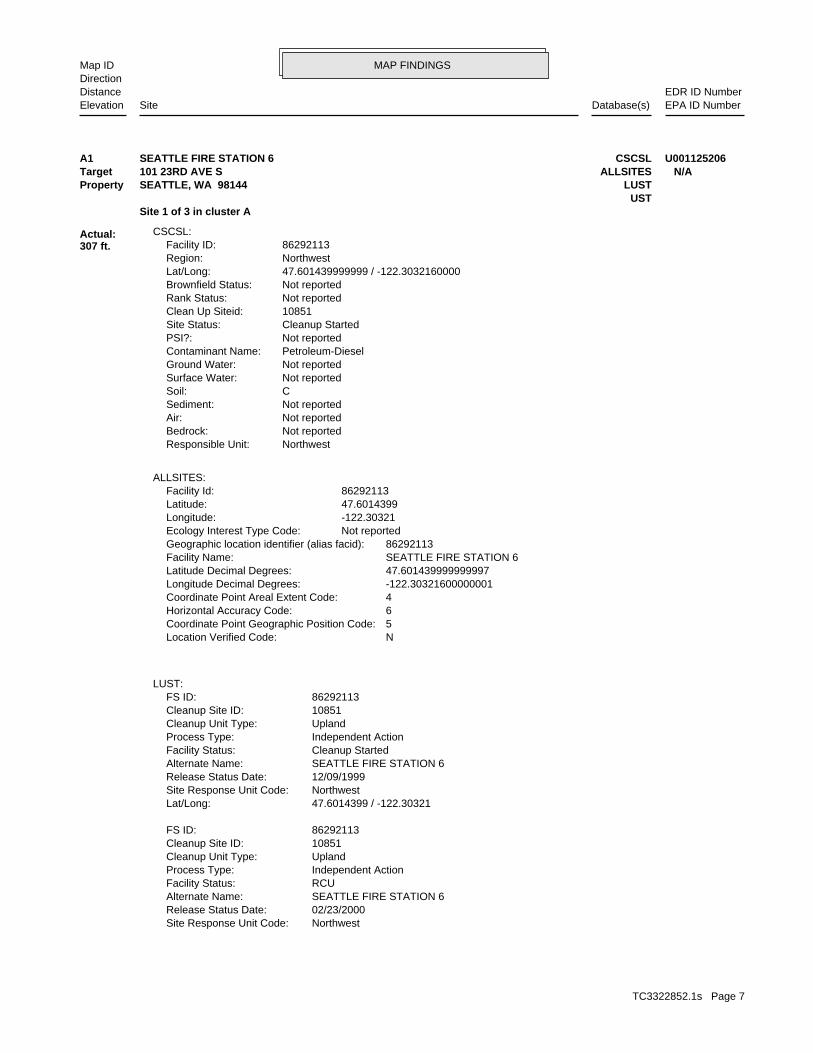
MAP FINDINGSMap IDDirection
EDR ID NumberDistanceEPA ID NumberDatabase(s)SiteElevation
NorthwestSite Response Unit Code: 02/23/2000Release Status Date: SEATTLE FIRE STATION 6Alternate Name: RCUFacility Status: Independent ActionProcess Type: UplandCleanup Unit Type: 10851Cleanup Site ID: 86292113FS ID:
47.6014399 / -122.30321Lat/Long: NorthwestSite Response Unit Code: 12/09/1999Release Status Date: SEATTLE FIRE STATION 6Alternate Name: Cleanup StartedFacility Status: Independent ActionProcess Type: UplandCleanup Unit Type: 10851Cleanup Site ID: 86292113FS ID:
LUST:
NLocation Verified Code: 5Coordinate Point Geographic Position Code: 6Horizontal Accuracy Code: 4Coordinate Point Areal Extent Code: -122.30321600000001Longitude Decimal Degrees: 47.601439999999997Latitude Decimal Degrees: SEATTLE FIRE STATION 6Facility Name: 86292113Geographic location identifier (alias facid): Not reportedEcology Interest Type Code: -122.30321Longitude: 47.6014399Latitude: 86292113Facility Id:
ALLSITES:
NorthwestResponsible Unit: Not reportedBedrock: Not reportedAir: Not reportedSediment: CSoil: Not reportedSurface Water: Not reportedGround Water: Petroleum-DieselContaminant Name: Not reportedPSI?: Cleanup StartedSite Status: 10851Clean Up Siteid: Not reportedRank Status: Not reportedBrownfield Status: 47.601439999999 / -122.3032160000Lat/Long: NorthwestRegion: 86292113Facility ID:
CSCSL:
Site 1 of 3 in cluster AUST
Actual:307 ft.
Property LUSTSEATTLE, WA 98144Target ALLSITES101 23RD AVE S N/AA1 CSCSLSEATTLE FIRE STATION 6 U001125206
TC3322852.1s Page 7

MAP FINDINGSMap IDDirection
EDR ID NumberDistanceEPA ID NumberDatabase(s)SiteElevation
Not reportedTag Number: 8/6/1996Tank Actual Status Date: Every 3 Years (suction tank check valve)Pipe Tightness Test: Not reportedTank Second Release Detection: Manual Inventory Control (daily)Tank Primary Release Detection: NonePipe Corrosion Protection: Not reportedPipe Second Release Detection: Not reportedPipe Primary Release Detection: Single Wall PipePipe Construction: Not reportedPipe Material: NoneTank Corrosion Protection: AnnualTank Tightness Test: Single Wall TankTank Construction: Not reportedTank Material: NoneTank Overfill Prevention: NoneTank Spill Prevention: Suction System Tank Check ValveTank Pumping System: 1/1/0001Tank Closure Date: 7/31/2000Tank Permit Expiration Date: RemovedTank Status: 2/23/2000TankSystem Status Change Date: RemovedTankSystem Status: 1/1/0001Tank Upgrade Date: 111 TO 1,100 GallonsCapacity: 1/1/1964Install Date: F6-1Tank Name: 41470Tank ID:
2066840422Phone Number: 1780489530010056UBI: 11.57760000002213Long Sec: 18Long Min: -122Long Deg: 5.1839999999879183Lat Sec: 36Lat Min: 47Lat Deg: 7909Site ID: 86292113Facility ID:
UST:
47.6014399 / -122.30321Lat/Long: NorthwestSite Response Unit Code: 07/01/2011Release Status Date: SEATTLE FIRE STATION 6Alternate Name: Cleanup StartedFacility Status: Independent ActionProcess Type: UplandCleanup Unit Type: 10851Cleanup Site ID: 86292113FS ID:
47.6014399 / -122.30321Lat/Long:
SEATTLE FIRE STATION 6 (Continued) U001125206
TC3322852.1s Page 8

MAP FINDINGSMap IDDirection
EDR ID NumberDistanceEPA ID NumberDatabase(s)SiteElevation
Quality Programs.Quality, Dam Safety, Hazardous Waste, Toxics Cleanup, and Waterfacility/site that is currently, or has been, of interest to the AirDepartment of Ecology. This system contains key information for eachmeans to query and display data maintained by the WashingtonWashington Facility / Site Identification System (WA-FSIS) provides a Environmental Interest/Information System
110015404702Registry ID:
FINDS:
Site 2 of 3 in cluster A
Actual:307 ft.
Property SEATTLE, WA 98144Target 101 23RD AVE S N/AA2 FINDSSEATTLE FIRE STATION 6 1007063919
Not reportedReport Title: Not reportedContact: 17County Code: 98-25Site Register Issue: Interim cleanup reportType of Report Ecology Received: North WesternRegion: TankWaste Management: SoilMedia Contaminated: Petroleum productsContaminants Found at Site: 02/28/00Date Ecology Received Report:
ICR:
Site 3 of 3 in cluster A
Actual:307 ft.
Property SEATTLE, WA 98144Target 101 23RD AVE. S. N/AA3 ICRSEATTLE FIRE STATION 6 S104485963
1951Year: CASTON J MName:
GASOLINE AND OIL SERVICE STATIONSType: 1940Year: CASTON JACKName:
GASOLINE AND OIL SERVICE STATIONSType: 1935Year: FINKELSTEIN LAZARUSName:
GASOLINE AND OIL SERVICE STATIONSType: 1930Year: FINKELSTEIN LAZARUSName:
EDR Historical Auto Stations:
279 ft. Site 1 of 2 in cluster B0.053 mi.
Relative:Higher
Actual:313 ft.
< 1/8 SEATTLE, WA NNE 124 23D AVE N/AB4 EDR Historical Auto StationsCASTON J M 1009355164
TC3322852.1s Page 9