Activities Pack for Schools - The SweetBeats · · 2017-10-03Caistor Roman Town Activities Pack...
42
1 Version May2016 Caistor Roman Town: Venta Icenorum Activities Pack for Schools
Transcript of Activities Pack for Schools - The SweetBeats · · 2017-10-03Caistor Roman Town Activities Pack...

1
Version May2016
Caistor Roman Town: Venta Icenorum
Activities Pack for Schools

2
Version May2016
Caistor Roman Town Activities Pack for Schools Contents 1 Introduction: why study Caistor Roman Town? 4 2 In school activities 5 Self-led activities in school
Living Timeline 5
Mapping (see Appendix 1) 7
What do Archaeologists do? (see Appendix 2) 9
Food and Drink (see Appendix 3) 11
Volunteer-led activities in school*
What’s in the box? (see Appendix 4) 13
3 On site activities 14 Volunteer-led activities on-site*
Activity 1: Who? What? Where? When? Why? How? 14
Activity 2. Welcome to the Forum 17
Activity 3: Walk back into time 19
4 Self-led activities on site 21
Collecting the treasure: Digital interpretation tour 21
Sketch the walls 21
How big was Venta Icenorum? 21
Be a Roman Soldier! 21
Treasure hunt in the Church 22
Panoramic view 22
Play pooh sticks on the bridge! 22
5 Wet-weather activity: some suggestions 23
6 Resources 24
Be a Roman Soldier! (see self -led activities) 24

3
Version May2016
Treasure Hunt : Church 27
Character images and back stories 31
Interpretation text 37
Powerpoints [download from website]:
Appendix 1: Living Timeline
Appendix 2: Mapping
Appendix 3: What do Archaeologists do?
Appendix 4: Food and Drink
Appendix 5: What’s in the box?
Appendix 6: Interpretation scheme
*See www.norfarchtrust.org.uk/schools for powerpoints and information on how to
book volunteer support for school visits.
The Norfolk Archaeological Trust’s production of this Activities Pack has been supported
by funding from Historic England, and developed with the help of volunteers from Caistor
Roman Project and Historic England’s Heritage Schools project. May 2016.
The Norfolk Archaeological Trust is registered as a charity (number 274604) Company limited by guarantee – registered in England (number 191668).
4
Version May2016
1 Introduction: Why study Caistor Roman Town?
Study of the site provides opportunities for fulfilling National Curriculum requirements in the following subject areas. History: Key Stage 1:
Events beyond living memory
Their own locality Key Stage 2:
Iron Age tribal kingdoms, farming and culture
The Roman Empire and its impact on Britain o the power of its army o British resistance, for example, Boudica o ‘Romanisation’ of Britain and the impact of technology o culture and beliefs, including early Christianity History
Britain’s settlement by Anglo-Saxons o Roman withdrawal from Britain in c. AD 410 and the fall of the western
Roman Empire o Anglo-Saxon invasions, settlements and kingdoms: place names
a study of an aspect of history or a site dating from a period beyond 1066 that is significant in the locality.
Key Stage 3:
a local history study
the study of an aspect or theme in British history that consolidates and extends pupils’ chronological knowledge from before 1066
Geography curriculum:
Key stage 1
develop knowledge about the world, the United Kingdom and their locality.
Key stage 2:
use fieldwork to observe, measure, record and present the human and physical
features in the local area using a range of methods, including sketch maps, plans
and graphs, and digital technologies.
English
ask relevant questions to extend their understanding and knowledge
use spoken language to develop understanding through speculating,
hypothesising, imagining and exploring ideas
5
Version May2016
2 In-school activities
Living Timeline (Appendix 1) Self-led activity
When did Venta Icenorum exist? A very L-O-N-G time ago! This activity looks at how this
place fits into our history locally and nationally with a Living Timeline
Purpose/ educational value: History:
Pupils develop their chronological knowledge and understanding of British, local and world history,
They address and sometimes devise historically valid questions English:
listen and respond appropriately to adults and their peers
ask relevant questions to extend their understanding and knowledge
use spoken language to develop understanding through speculating, hypothesising, imagining and exploring ideas
Outcome: Students develop their chronological knowledge of historical events. Time needed: from 30 mins to 1 hour Resources needed:
Tabards labelled with centuries – 1st century up until 21st century. In smaller
group use chairs, stray adults or cuddly toys to make up the numbers necessary
to wear each tabard [School to supply]
Timeline cards: these are a set of cards with a mixture of national and local
events written on them and are on the powerpoint
Powerpoint appendix 1
Activity
Pupils are given tabards randomly – and are given a few minutes to get
themselves into chronological order. Pupils wearing tabards are called
‘timeliners’
Remaining students are the ‘gofors’. They are given the Timeline cards and it’s
their job to work out which card should be given to which ‘timeliner’
Match years to centuries
Put national events in correct century (prior learning required)
6
Version May2016
Put events in the history of Norwich in correct century (prior learning required)
Add events connected to Venta Icenorum
Take photos as a record
Ask for comments – any surprises?
7
Version May2016
Mapping Self-led activity
This activity provides the opportunity for pupils to locate Venta Iceonrum in its
international, national and historical contexts, and prepares them for understanding the
layout of the site when they visit.
Purpose/ educational value: History:
Pupils develop their chronological knowledge and understanding of British, local and world history,
They address and sometimes devise historically valid questions
They develop their understanding of change, cause, similarity and difference, and significance through their exploration of the site.
Geography:
name and locate places in the area
identify human and physical characteristics, key topographical features and land-use patterns; and understand how some of these aspects have changed over time
human geography, including: types of settlement and land use, economic activity including trade links, and the distribution of natural resources including energy, food, minerals and water
English:
listen and respond appropriately to adults and their peers
ask relevant questions to extend their understanding and knowledge
use spoken language to develop understanding through speculating, hypothesising, imagining and exploring ideas
Outcome: Students practice using maps and plans, and develop an understanding of the history and layout of the site; its significance and its size.
Time needed: 30 minutes – 1 hour
Resources needed:
Mapping powerpoint
8
Version May2016
Activity
Use the Mapping powerpoint resource to get pupils thinking about the context
of Venta Icenorum within the Roman Empire. Was it at the centre of the Empire?
Was it an important town in Britain?
Print off Aerial photos 1 (the ‘base’ photo) and ask pupil groups to label anything
they can see
Examine Aerial photos 2-4 for any other features and add labels to the base
photo
Examine the slides of the site as it appears now, and try to locate them on the
base photo
Examine the two reconstruction drawings and add any further labels.
[The drawings are different because one predates the survey and excavations
carried out after 2006. These showed that although the road grid was set out for
a larger town, it was never fully constructed. The settlement was smaller than
previously thought with areas of open space.]
Finally, look at the labelled plan at the end, to compare with the pupils’ own
work; and to add further labels.
9
Version May2016
What do Archaeologists do? Self-led activity
This activity is designed to introduce pupils to the idea of archaeological investigation.
It would be a good idea to go through this powerpoint before doing the ‘What’s in the
box?’ activity, so that pupils will understand the context of the finds.
Purpose/ educational value: History:
Pupils develop their chronological knowledge and understanding of British, local and world history,
They address and sometimes devise historically valid questions
They develop their understanding of change, cause, similarity and difference, and significance through their exploration of the site.
Geography:
name and locate places in the area
identify human and physical characteristics, key topographical features and land-use patterns; and understand how some of these aspects have changed over time
human geography, including: types of settlement and land use, economic activity including trade links, and the distribution of natural resources including energy, food, minerals and water
English:
listen and respond appropriately to adults and their peers
ask relevant questions to extend their understanding and knowledge
use spoken language to develop understanding through speculating, hypothesising, imagining and exploring ideas
Outcome: Pupils will know about different archaeological techniques, and understand that excavation is not the only way of finding out about what’s underground. Time needed: 30 mins Resources:
What do Archaeologists do? powerpoint
10
Version May2016
Activity
The powerpoint provides a general introduction to some of the techniques used by
modern archaeologists to explore historic sites. It asks pupils to think about ways of
finding out about what’s underground without digging.
Some pupils may have watched Time Team and similar programmes and may therefore
be able to come up with techniques such as ‘geophys’ or photography and filming from
the air. Other common techniques include field walking, metal detecting and
documentary research.
The powerpoint also shows what excavations look like, and the kinds of things that are
found (‘finds’) – this will help pupils understand the ‘finds’ in the ‘What’s in the box’
activity.

11
Version May2016
Food & Drink Self-led activity
This activity gets pupils to think about what kind of food and drink was available in Roman times, and to compare it with modern diets Purpose/ educational value: History:
Pupils develop their chronological knowledge and understanding of British, local and world history,
They address and sometimes devise historically valid questions
They develop their understanding of change, cause, similarity and difference, and significance through their exploration of the site.
Geography:
human geography, including: types of settlement and land use, economic activity including trade links, and the distribution of natural resources including energy, food, minerals and water
English:
listen and respond appropriately to adults and their peers
ask relevant questions to extend their understanding and knowledge
use spoken language to develop understanding through speculating, hypothesising, imagining and exploring ideas
Outcome: Pupils will develop insights into the lives of people in the Roman period, through exploring their diet, where different foods come from, and when they became available Time needed: 30 minutes Resources
Food and Drink powerpoint provides images and information on food and drink in the Roman period
List of foods available during Roman period (see below) Activity Children are shown a collage image of food and drink on the powerpoint and asked to group them into items that were available in the Roman period and those that were not.
Pupils could work in groups to draw up their lists.

12
Version May2016
Get them to think about the questions they need to ask: e.g. Where do the items or their ingredients come from? How would they have been brought to Venta Icenorum? How are they made?
Once each group has completed their list, show them the next slide which has the food grouped correctly
What did they get right? What did they get wrong? Why? List of foods The people who lived at Venta Icenorum did not consume as much wine or olive oil as most Romano-British settlement in other parts of the county. Excavation has shown that the area around the town was grazed by cattle, and that rye was grown for bread and for brewing. The diet of the population was rich in meat, especially beef. Below is a list of food and drink which might have been consumed at Venta.
• Vegetables: purple carrots, cucumbers, cabbages, radishes, garlic, onions, leeks, peas, broad beans, celery, turnips, asparagus.
• Olives and olive oil. • Herbs: Rosemary, mint, thyme, bay, basil, cumin – and a strong tasting fish
sauce called “garum” or “liquamen” • Fruit and nuts: Apples, grapes, mulberries, cherries, walnuts and sweet
chestnuts. • Animals: Chickens, rabbits, pheasants, brown hares, sheep, cattle (milk and
beef), pigs, geese, horses, dogs, deer, wild boar … and dormice! • Mussels, oysters and fish • Honey • Drink: Wine (imported and local), mead, ale and weak beer. • Water was usually clean enough to drink in the countryside, as long as it wasn’t
polluted by the runoff from animal waste or industry. Romans thought it very uncivilised to drink wine neat– it was always mixed with water at the table.

13
Version May2016
Volunteer-led activities in school
What’s in the box? Volunteer-led activity This activity provides the opportunity for pupils to handles real archaeological finds, and to start formulating questions about where the objects came from, what they were for, and what kind of people made or used them. Purpose/ educational value: History:
Pupils develop their chronological knowledge and understanding of British, local and world history,
They address and sometimes devise historically valid questions
Geography:
name and locate places in the area
identify human and physical characteristics, key topographical features and land-use patterns; and understand how some of these aspects have changed over time
human geography, including: types of settlement and land use, economic activity including trade links, and the distribution of natural resources including energy, food, minerals and water
English:
listen and respond appropriately to adults and their peers
ask relevant questions to extend their understanding and knowledge
use spoken language to develop understanding through speculating, hypothesising, imagining and exploring ideas
Outcome: Students have an understanding of the history and development of the site; what kind of people lived there, what kind of activities took place there (domestic, industrial, commerce, administration, tax collection etc) Time needed: from 30 mins to 1 hour Resources:
Volunteers will provide boxes of archaeological finds for pupils to handle and identify.
What’s in the box? Powerpoint sets out how to explore the finds and formulate questions and conclusions about them using inference squares.

14
Version May2016
3 On site activities Volunteer led activities on site
Activity 1: Who? What? Where? When? Why? How? Volunteer-led activity Description: Volunteers lead a group (15 students max) and use questions at certain points on the walk to engage students in an exploration, to help them work out what the site is, and unpick its history and significance. The questions will be designed to get the students to use all their senses in appreciating the site; encourage them to hypothesise and test their own theories; build on their prior knowledge, and ask their own questions. Volunteers will ask the students to count their footsteps as they go and use this to estimate the size of the site. Purpose/ educational value: History:
Pupils develop their chronological knowledge and understanding of British, local and world history,
They address and sometimes devise historically valid questions
They develop their understanding of change, cause, similarity and difference, and significance through their exploration of the site.
Geography:
name and locate places in the area
identify human and physical characteristics, key topographical features and land-use patterns; and understand how some of these aspects have changed over time
human geography, including: types of settlement and land use, economic activity including trade links, and the distribution of natural resources including energy, food, minerals and water
English:
listen and respond appropriately to adults and their peers
ask relevant questions to extend their understanding and knowledge
use spoken language to develop understanding through speculating, hypothesising, imagining and exploring ideas

15
Version May2016
Outcome: Students have an understanding of the history and development of the site; of its significance; of its layout; of its size; etc Time needed: from 15 - 45 minutes Location on site: East end of site (starts at grassy area to the right of the car park when facing shelter) )
1. Picnic area 2. Story telling stone in the story telling grove 3. At the end of the ditch 4. Up on the Bank 5. North East Corner
This activity is very flexible and can be shortened or extended as necessary; can start and finish in different places; adapts to different levels of expertise among volunteers. Resources: Question sheet
1. Picnic area What can you see? What might that ditch and bank be? What (do you think) used to be here in the past? What can you hear? What important means of communication can you see? Roads? Railways? River? Challenge: What did it look like 2000 years ago?
2. Story telling stone in the story telling grove What were the walls built of? How was it built? Where did the materials come from? Who built them? When were they built? Why did they want walls? Challenge: At the next stop, everyone has to give a word for to describe the ditch and bank
16
Version May2016
3. At the end of the ditch
Everyone gives their words Why did they build all this?
4. Up on the Bank How big was Venta Icenorum? (They could be asked to trace the outline with their fingers – but remember that the walls were a later intervention and that the town previously covered a larger site) How many football pitches? Is it bigger than your school? Who lived here? Who were the Iceni? What happened to the Iceni Why was a town built here? Where did they come from? How long ago did people live here? How did they feed themselves? How did they travel? How did people earn a living? Challenge: Any questions? Where has it all gone?
5. North East Corner Look across at the large house and think about the materials it is built with. Point out direction of Norwich When did the people leave? What happened to the population of the town? Why did it disappear? At this point the group could continue down the steps to view the North Walls Or Go to the Church What did the people of Venta believe in? Why was the church built here?
17
Version May2016
Activity 2. Welcome to the Forum! Volunteer-led activity
Description: Volunteers work with a group (15 students max) to reconstruct the Forum of Venta Icenorum in 350 A.D. Start at South Gate interpretation board
Use the map and interpretation boards to locate the main Roads in the Town, the Forum, Basilica and Temple
The group paces out the distance from the South Gate to the turning into the Forum along the route of the Roman street. [Walk along the main road from the south gate towards the north gate - when you are level with the west gate you are at the main cross roads. Turn right towards the direction of the church - this takes you towards the position of the east gate – and head for the tall conifer tree on the horizon) Walk about 100 paces and you are level with the Forum site which will be on your right. The Forum was approximately 50 metres square, according to the plan].
Having located the corner of the Forum, the children then work in small groups and are challenged to find the other three corners of the forum. These are marked with flags as are the Basilica and temple
If we were stood here 2000 years ago, what would we see?
Discuss differences and similarities between the Roman Venta and 21st century Norwich (or their town) – similarities and differences; when did it change?
If we were stood here 2000 years ago, who would we meet? Each child is given a character card representing the people who lived in Venta. Card will tell them where to stand and have a simple activity to role play. They are given 5 minutes to carry this out.
How do we know? Find the trench from the archaeological dig and use illustrations to show them what is underneath
Purpose/ educational value: History:
Pupils develop their understanding of similarity and difference
‘Romanisation’ of Britain and the impact of technology especially on public health
culture and beliefs English:
listen and respond appropriately to adults and their peers
ask relevant questions to extend their understanding and knowledge
participate in discussions, presentations, performances, role play, improvisations
18
Version May2016
Geography
Map skills Maths
Grid references; shapes; measuring and estimating Outcome: Pupils have an understanding of the life of the people who lived in Venta Icenorum and how it was similar/different to ours. Time needed: 45 mins – 1 hour Resources: Flags; plans and maps of Town and ‘character cards’ (in Volunteer folder) Location on site: Central site This activity is very flexible and can be shortened or extended as necessary; can start and finish in different places; adapts to different levels of expertise among volunteers.

19
Version May2016
Activity 3: Walk back in time Volunteer-led activity Description: Volunteers lead a group from the shelter near the car park to the South Gate. Pupils are told that this is a ‘walk back in time’.
1 step = 10 years
Pupils work as a group and count each pace out loud, as instructed by the
volunteer.
Ask the pupils to calculate how many steps they need to take for each event.
‘Now we’ve got to go back 90 years? How many steps??’
Also, see if they can give dates for events? ‘Who knows when Henry VIII was
king?’
Each of the events listed below are marked with a flag.
At the end the pupils can look back at the flags and see how far back in time they
have travelled.
NOW: 2016 1 step: goes back to 2006 [before they were born?] 9 steps = 90 years: WWI starts 1914 50 steps = 500 years: Henry VIII/Tudors 16th century 50 steps – 500 years: Normans invade 1066 20 steps - 200 years: Vikings invade Norfolk AD865 40 steps - 400 years: Anglo-Saxons invade AD410 12 steps – 120 years: Walled Roman Town at Caistor circa AD280 We have arrived in the Roman Period!! TOTAL 182 steps Purpose/ educational value: History:

20
Version May2016
Pupils develop their chronological knowledge and understanding of British, local and world history,
They address and sometimes devise historically valid questions
They develop their understanding of change, cause, similarity and difference, and significance through their exploration of the site.
Geography:
name and locate places in the area
identify human and physical characteristics, key topographical features and land-use patterns; and understand how some of these aspects have changed over time
human geography, including: types of settlement and land use, economic activity including trade links, and the distribution of natural resources including energy, food, minerals and water
English:
listen and respond appropriately to adults and their peers
ask relevant questions to extend their understanding and knowledge
use spoken language to develop understanding through speculating, hypothesising, imagining and exploring ideas
Outcome: Students have an understanding of the context of the town in time, and the history and development of the site; Time needed: 15 minutes Resources: Flags; Timeline and steps instructions (as above) Location on site: Start at shelter by car park
21
Version May2016
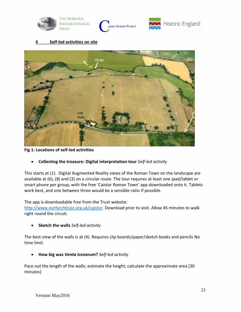
4 Self-led activities on site
Fig 1: Locations of self-led activities
Collecting the treasure: Digital interpretation tour Self-led activity
This starts at (1). Digital Augmented Reality views of the Roman Town on the landscape are available at (6), (8) and (3) on a circular route. The tour requires at least one ipad/tablet or smart phone per group, with the free ‘Caistor Roman Town’ app downloaded onto it. Tablets work best, and one between three would be a sensible ratio if possible. The app is downloadable free from the Trust website: http://www.norfarchtrust.org.uk/caistor. Download prior to visit. Allow 45 minutes to walk right round the circuit.
Sketch the walls Self-led activity
The best view of the walls is at (4). Requires clip boards/paper/sketch books and pencils No time limit.
How big was Venta Icenorum? Self-led activity
Pace out the length of the walls; estimate the height; calculate the approximate area [30 minutes]
22
Version May2016
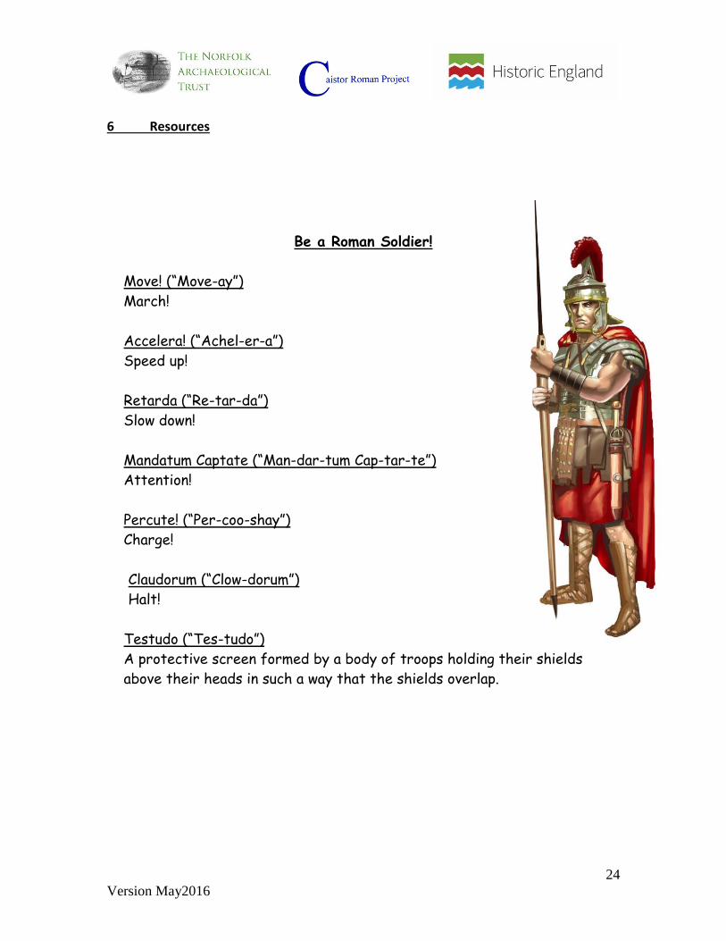
Be a Roman Soldier! Self-led activity [See Resources section for info sheet] [15 minutes]
Orders were given in Latin, so soldiers from different countries could understand them. March across the town between the south/north gates (5) to (6); use Latin commands and play simeous dictate (Simon says!):
Teacher reads out each order and explains what they mean (it is a good idea to practise these at school beforehand). Teacher explains that every time they call the order out, the children have to follow it. Practice each order once or twice and then play Simon Says… (Simeus Dictet) using the different orders until a winner is found. Repeat game maybe 2 or three times depending on time.
Treasure hunt in the Church (9) Self-led activity
Use treasure hunt sheet which will help students search for key features in and outside the church – and USE THE LOO! [30 minutes] Make sure the pupils realise that the church is not Roman – but it may have been built on the site of a Roman church.
Panoramic view (10) Self-led activity
Get some exercise and walk up the hill to point 10 (allow 10 minutes from the bridge) where there is a panel with a view of the Roman Town, and a bench; enjoy the view over the site and then see if you can find the Roman road on the way back down. Between April to August the field is full of meadow flowers – these could be sketched/identified/species counted. [30 minutes]
Play pooh sticks on the bridge! Self-led activity
And discuss why the town was built by the river [30 minutes].
23
Version May2016
5 Wet weather activities: some suggestions Use church as a base for indoor activities:
Volunteer-led: If possible complete the short walk from (1) to (3) and back to the church (9). Volunteers will then be able to lead Activity 1 inside the church
Volunteer-led: A modified version of Activity 2: Use pictures of ‘characters’ to discuss who might have lived at the site, what kind of houses they lived in, how they earned a living and what food they might have eaten. If the weather clears the students will then be ready to do the role play.
Self-led activity in church - treasure hunt sheet
Self-led activity in church - sketching in church - windows, arches, the font.
24
Version May2016
6 Resources
Be a Roman Soldier!
Move! (“Move-ay”)
March!
Accelera! (“Achel-er-a”)
Speed up!
Retarda (“Re-tar-da”)
Slow down!
Mandatum Captate (“Man-dar-tum Cap-tar-te”)
Attention!
Percute! (“Per-coo-shay”)
Charge!
Claudorum (“Clow-dorum”)
Halt!
Testudo (“Tes-tudo”)
A protective screen formed by a body of troops holding their shields
above their heads in such a way that the shields overlap.

25
Version May2016
Caistor St Edmund’s Church Activity Sheet for Schools – Treasure Hunt
1 Outside:
The photograph shows how
the Church you see today has
been built up over the
centuries.
Can you spot the different
parts of the building, the
evidence of a different roof
and different style of
windows?
Can you find the
gargoyles high up on the
tower above the window.
What job do they do?
Can you find evidence that they have reused material from the Roman town
walls?
26
Version May2016
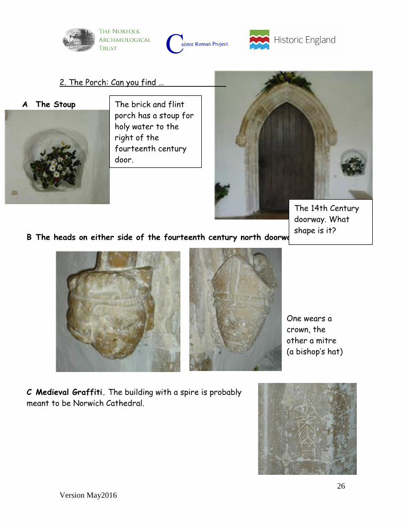
2. The Porch: Can you find …
A The Stoup
B The heads on either side of the fourteenth century north doorway.
One wears a
crown, the
other a mitre
(a bishop’s hat)
C Medieval Graffiti. The building with a spire is probably
meant to be Norwich Cathedral.
The brick and flint
porch has a stoup for
holy water to the
right of the
fourteenth century
door.
The 14th Century
doorway. What
shape is it?
27
Version May2016
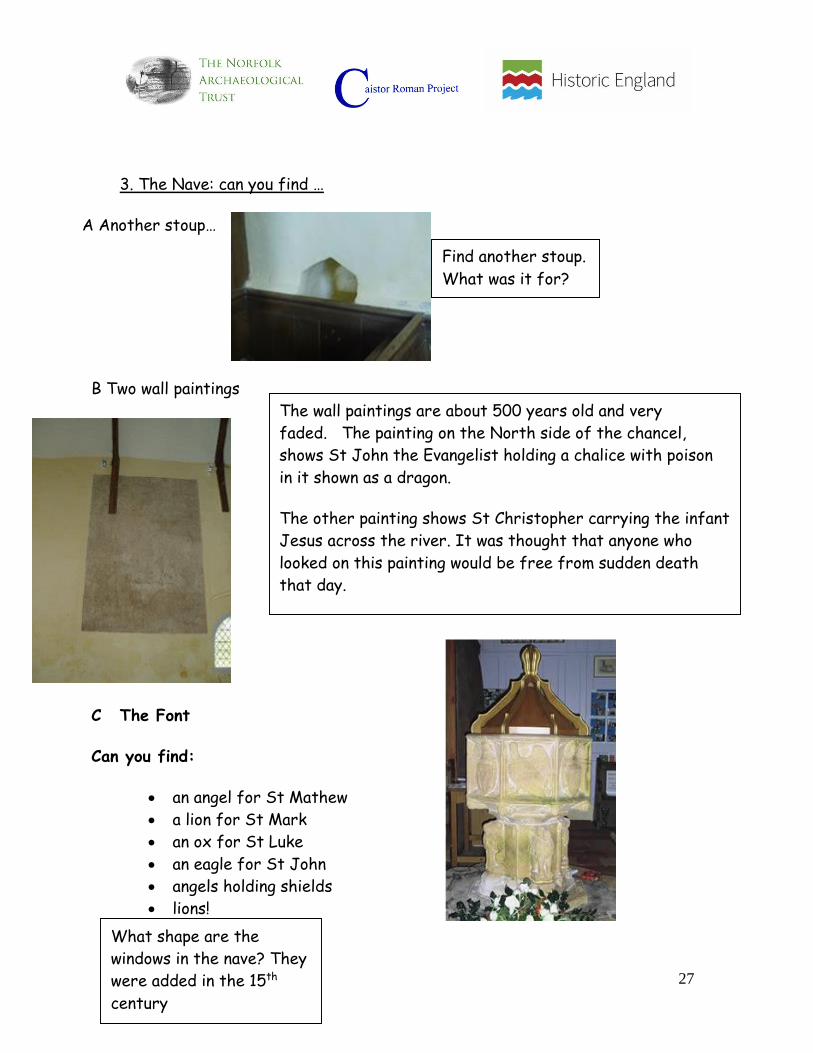
3. The Nave: can you find …
A Another stoup…
B Two wall paintings
C The Font
Can you find:
an angel for St Mathew
a lion for St Mark
an ox for St Luke
an eagle for St John
angels holding shields
lions!
Find another stoup.
What was it for?
The wall paintings are about 500 years old and very
faded. The painting on the North side of the chancel,
shows St John the Evangelist holding a chalice with poison
in it shown as a dragon.
The other painting shows St Christopher carrying the infant
Jesus across the river. It was thought that anyone who
looked on this painting would be free from sudden death
that day.
What shape are the
windows in the nave? They
were added in the 15th
century

28
Version May2016
4. The Chancel: Can you find …The Chancel
A Two thirteenth century’ lancet’ windows on each side.
B The Priest’s Door
C The Organ
D The date on this gravestone
The priest's door dates
from the Tudor period. The
priest would enter the
Chancel through this
separate door. Ordinary
people were not allowed in
the chancel.
Lancet windows are small
narrow windows and were
popular in the 13th century
The Organ – can you work out
how they pumped air into it
before they had electricity?

29
Version May2016
Venta Icenorum characters
Woman using a wool comb
This woman was born in the area into a local Iceni family. She may have had a job within
the community of making clothes to sell at markets or to people in the area.
To occupy her day this woman probably made clothes or cloths to sell at markets and to
richer people, she may also have been a mother and so would have looked after her
children as well.
This woman may not have had time for leisure activities but may have enjoyed cooking.
She may have enjoyed simple games played at home with the children. Her husband was
likely to be a craftsman.
She probably lived in a fairly basic house but it was would have been warm and nicely
decorated. Because of her work as a weaver and potentially her husband’s work as a
craftsman she may have been able to afford some meat and fish.
[A wool comb was found during excavation at Caistor and can be seen at Norwich Castle
Museum, and a 3-D image collected at the site using the Caistor Roman Town app]

30
Version May2016
Builder The builder might have been the husband of the wool comber. He was a local man and had perhaps learned his trade working for the various Roman institutions in the town: the basilica, the temples, or perhaps building houses for some of the richer occupants. His own family house might have been a traditional Iceni one - round and wooden with a thatched roof - or he might have lived in a Roman-style house but probably without expensive features such as mosaic floors. His biggest chance for well-paid work might have come in around 270 AD when the Roman administration decided to undertake their biggest project in Caistor: the building of the town walls. The walls were built in sections about 20 metres long and it is likely that different builders took responsibility for a section at a time. He is shown here carrying a Roman style spade. It is made of wood with just its sharp edge made of iron. Iron was still an expensive material. [A footprint of a boot was found in the lime mortar during repairs to the walls at Caistor
– probably left their by a builder. During excavation a bone was found which had been
used for mixing lime - this can be seen at Norwich Castle Museum]

31
Version May2016
Man with curse tablet
A curse tablet was a request to the gods for a wrong to be put right. It was usually written on a thin sheet of lead (a soft metal). Often the victim offered a reward to the gods. At Caistor a curse tablet was found where the writer listed things that had been stolen from him and then asks for justice from Neptune, god of water. The stolen items included ten pewter mugs, a cap, a mirror, some bracelets and a pair of leggings – which were worn by men, not women. The writer offers Neptune the leggings if everything is returned.
The curse tablet was written in Latin when probably few local people could write, and the list of objects suggest he was not poor. Perhaps the writer was a local man of middling economic status who had received an education and carried out administrative tasks for the Tax man. He probably lived in a Roman-style house, and had adopted a Roman style of living, which included consuming olive oil and wine, and worshipping Roman gods.
[This curse tablet was found during excavation at Caistor and can be seen at Norwich
Castle Museum, and a 3-D image collected at the site using the Caistor Roman Town
app]

32
Version May2016
Gladiator
Within the Roman Empire there was a large community of Gladiators. Many lived in the
northern European areas of the Empire. With the expansion of the Roman Empire into
Britain, lots of Gladiators migrated to find work. This gladiator may have moved from
northern Europe or he may have been born into a family in Britain and gone into the
profession.
This gladiator was probably respected but not of very high economic status. He was not
paid much for his work, but was given the means to live, such as housing and basic food.
He may have lived in barracks with other gladiators and may have been part of the town
defence. They were probably fed a basic diet of bread and vegetables with limited meat.
In his free time this gladiator may have played board games or gambled or gone to game
houses.
The every-day clothes of this gladiator may have been made of linen and would have been
simple with maybe some armour over the top and a weapon.
[This site of the amphitheatre, to the south of the walled town, was identified through
aerial photography and geophysical survey]

33
Version May2016
Woman at bathhouse using game counters Born in Syria, North Africa. With the expansion of the Roman Empire into Britain people
from North Africa and the Mediterranean moved here and took up positions as soldiers,
traders and officials. These people would have filled the important positions in the army
and administration. This woman could have come over with a husband in the army. She
might have moved here as a small girl with her family, or she might have been born here.
She would have been of high status and lived in a family home built around a central
courtyard. The walls of the main rooms would have been covered in coloured plaster and
the floors in mosaics. Rich families would have had water pumped straight to their houses
through lead-lined pipes. Although many people in Roman Britain did not have much
spare time, most enjoyed playing board games and many game counters have been found
at Venta Icenorum.
The Romans introduced many new foods to Britain and because of the high status of this
woman she was probably able to eat them. She may have eaten meals with fish and meat
such as cattle, guinea fowl, chickens and rabbits. This may have been served with
vegetables such as onions, leeks, cabbages, peas, celery and asparagus.
This woman probably wore clothes made out of wool or linen. Decorative pins and
brooches would have been used to fasten her clothes.
[Numerous gaming counter were found during excavation at Caistor. Examples can be
seen at Norwich Castle Museum as well as what appears to be part of a gaming ‘board’;
and a 3-D image of a counter collected at the site using the Caistor Roman Town app]

34
Version May2016
Woman in market This woman was probably born into an Iceni family in the Roman Town area and had lived
there her whole life without travelling much. She was probably born into a lower class
farming family who maybe owned a small bit of their own land.
She probably lived with her family and a few others in a timber hut or house which they
may have shared with some animals. The house would have been heated with a fire and
they would have lived on a basic diet of bread and vegetables with the occasional fish or
small meats.
This woman may have been a mother who worked at looking after her family and maybe
as a servant for the richer people in the settlement. She may have done odd jobs for
money and her husband may have been a manual worker on a farm or in a workshop.
This woman probably didn’t have time for many leisure activities but may have enjoyed
simple games at home or going to the market to buy goods that they couldn’t produce at
home.
The clothes of this woman were probably of less good quality that those of the woman in
the bathhouse but they may have been of a similar style.
35
Version May2016
Interpretation scheme text 2015
1 Welcome to Norfolk’s lost Roman capital
Beneath these fields lie the remains of the Roman town of Venta Icenorum (pronounced Venta I-ken-or-um) which means ‘Market of the Iceni’ Venta Icenorum revealed In the dry summer of 1928 aerial photography revealed the pattern of Roman streets and buildings inside the walls of the town. The existence of the Roman town had long been known, but these remarkable images awakened national interest. An excavation followed (1929 – 35) which found evidence for major public buildings including the forum, a bath-house and the south gate. These were later re-buried. Between 2006 – 2014 the University of Nottingham led an exciting programme of excavation and research which has radically changed our understanding of the town and the people who lived here.
2 How do we know that there was a town called Venta Icenorum here?
The Roman writer, Ptolemy, described Venta as the one significant town in the territory of the Iceni tribe. Venta Icenorum is also included in the 3rd-century Antonine Itinerary, a Roman document which listed settlements in the Roman Empire. Who were the Iceni? Before the Roman conquest, Norfolk was under the control of the Iron Age tribe known as the Iceni (usually pronounced Ike-eeny). After the Roman invasion of AD43, the Iceni king, Prasutagus, made an alliance with the Roman authorities. When he died the alliance broke down. Revolt! In AD60/61 Prasutagus’s wife, Boudica, led a revolt against Roman rule. The Iceni rampaged through the south of the region, burning towns including Colchester and London before they were defeated by the Roman army. What happened to the Iceni?
36
Version May2016
The fate of the Iceni after the revolt is unknown but it is likely that the region continued to be inhabited and farmed by the Iceni. Most of the inhabitants of the Roman town were probably of local origin. The tribal name was present in the name Venta Icenorum recorded over 200 years after the revolt, and archaeological evidence suggests that many local customs continued.
3 The birth of the Roman town
The settlement at Venta began after the Iceni revolt of AD 60/61, and may have developed from a Roman army base. Traces of human occupation here date back to the Mesolithic period (7000-3000 BC). The presence of a number of prehistoric monuments in the area shows that the Roman town was part of a long history of settlement in the region. The new settlement was small and without paved streets. But the people living here used high quality pottery from Gaul, and some of the buildings were decorated with fine painted wall plaster – fragments of this decoration were found during excavation. Around 60 years later (AD 120) the earliest known gravelled roads were laid out and the grid-system of streets began to develop. Soon after, stone buildings started to appear. At this time the town was surrounded by ditches – not walls - and covered a much larger area than the current walled enclosure. When were the walls built? The walls were built in the late 3rd or 4th century. Many towns all over Roman Britain built walls at this time in response to increasing attacks from abroad by Germanic raiders. The end of the Roman town In the early 5th century occupation of the area inside the walled town probably came to an end. But the site was not completely abandoned. Evidence from excavations shows that the area outside the walls was soon occupied, possibly by settlers from across the North Sea. Their way of life was very different from those who had lived in the Roman town. Venta remained an important place during the Anglo-Saxon period until the 8th century when Norwich took over as the main centre of settlement in the region.
4 A Home for Wildlife

37
Version May2016
These days the site supports important wildlife habitats, which the Norfolk Archaeological Trust is conserving and developing. The site is kept under pasture which is the best way to protect below-ground archaeological remains. Grazing controls invasive weeds and provides habitat for wild grassland flowers. Lime mortar used in the Roman walls encourages chalk-loving flowers on the south and west ramparts - a rare habitat-type for Norfolk. The River Tas supports a wide variety of insects, birds, fish and small mammals. On the other side of the bridge, Dunston Field is maintained as a wild-flowering hay meadow. In summer this provides a haven for nesting skylarks, butterflies and other insects. The ongoing management of the site to support wildlife habitats has been made possible through funding from a Natural England Higher Level Stewardship agreement. Guidebooks are available for purchase in the church. Visit Norwich Castle Museum to see some of the exciting finds shown in the panels around the site: http://www.museums.norfolk.gov.uk
5 Discovering Norfolk’s Lost Roman Capital
Around 1,700 years ago, you would have been looking across the town of Venta Icenorum. Beneath your feet lie the remains of the defensive wall that surrounded the town in the late 3rd and 4th centuries. The forum with its imposing basilica was the political centre of Icenian territory under Roman rule. All of Norfolk and parts of Suffolk and Cambridgeshire were governed from here. Who lived here? Around 2,000 people lived here in the 4th-century – similar to a large village today. Only some aspects of Roman life were adopted at Venta. Little evidence has been found for elaborate courtyard houses of the type found in other towns in Roman Britain. And the population do not appear to have consumed much wine or olive oil.
38
Version May2016
But tests on one set of human remains showed that a man found buried here had grown up outside Britain – probably in the Mediterranean. This suggests that while most people living in the town were locals, some people came from other parts of the Roman Empire. Traditional pre-Roman ways of life seem to have continued alongside new influences from abroad. Some of the population could read and write. Many bronze and iron styli for writing on wax tablets have been found here, as well as ink wells and pen nibs. These were used for keeping records relating to tax collection in the region - an important activity organised from the town. 6 Entertainment Around 1800 years ago you would have been able to see the three lines of the old town ditches from here, and the town’s amphitheatre. The oval amphitheatre was made from earth and timber. Unlike amphitheatres in other Roman towns it was never rebuilt in stone. It may not have been used for long. Entertainment could have included staged hunts with bears or other exotic imported animals, and fights between gladiators. Strange graves In the late 4th century this area contained a graveyard. The excavated burials from this spot are unusual, with the bodies sometimes placed in existing pits, or buried in very shallow graves in strange positions. The reasons for this are not yet understood. 7 The industrial suburbs This field was once a busy suburb of the Roman town. The large number of late Roman coins found in this field suggests that the site was a commercial area in Roman times. The geophysical survey shows the road which joined Venta Icenorum to the major Roman road to Colchester – now the A140. The raised line of the road can still be seen running across the field in front of you. Just like modern times, industrial activity grew up on either side of the road on the outskirts of town. The survey shows a large complex of buildings next to the river, which may have been a Roman water mill.

39
Version May2016
After the Roman period This field remained a focus of activity in Anglo-Saxon times. Anglo-Saxon burials were found when the railway was built in the 19th century, and Anglo-Saxon buildings have been identified using aerial photography, geophysics and excavation. Coins recovered by metal detecting show that the people living here had contacts across Europe. All this evidence suggests that the site remained an important regional centre after the Roman period.
8 Viewpoint at top of Dunston Field Panoramic reconstruction of walled phase (including water mill, amphitheatre, cemetery and extra-mural temple) 9 The West Gate to the River Tas The West Gate was probably the most important entrance into the town. The River Tas could be crossed at this point giving access to the main roads to the north and south. Recent surveys and excavation suggest that the river here was never much deeper than it is now. In the Roman period it was slightly wider, with marsh and reed beds at either side. Only boats with a shallow draft or flat-bottoms could have reached the town. The sharp turn in the river at this point may indicate the position of a Roman timber bridge which caused a change in the river’s course - but no trace of a bridge has been found so far. The Bath-house Bath-houses were a centre of social and cultural life in Roman towns. The baths were a focus of entertainment that probably included cock fighting and gambling. Numerous bone and pottery gaming counters have been found all over the town. The baths were supplied by a wooden pipeline that brought water from a spring north-east of the town. Geophysical survey detected the iron collars that connected the lengths of wooden water pipe - this discovery made it possible to trace the route of the pipeline.

40
Version May2016
10 How did people earn a living?
Venta was a centre of industry, while the wider countryside was farmed. Evidence has been found here of pottery and glass production, bronze working, iron smelting and blacksmithing. A hearth, probably used by a blacksmith, was excavated close to this spot. Excavation has shown that the area around the town was grazed by cattle, and that rye was grown for bread and for brewing. The diet of the population was rich in meat, especially beef. Parts of animals that were not eaten were made into useful things. Worked bone and tools connected to wool production have been found here.
11 Defending Venta Icenorum
Although the walls of the town are its most visible feature, for most of its active history they did not exist. The early Roman town covered a much larger area and was surrounded by ditches, not walls. These probably marked the town’s boundaries and were not a real defence against attackers. The ditches were filled in by the end of the 2nd century and the town may have been unprotected for a time. When were the walls built? These walls and huge ditches were probably constructed around the town in the late 3rd century. Building the walls and ditches was a major work of engineering. Most of the original facing stone has been lost over the centuries but some is still in place at the bottom of the section in front of you. The walls were topped with a parapet and walkway and may have been painted with white limewash, making the town highly visible in the landscape. Why were the walls built? The building of the walls was a sign of the town’s increased importance as part of the defences built against invasion from the North Sea. Venta was part of a group of fortified Roman sites which included the shore forts at Burgh Castle and Caister-on-Sea. The walls of Burgh Castle are of similar design to those of Venta Icenorum and may well date from the same period.
41
Version May2016
12 What did the people of Venta Icenorum believe in? Two temples have been discovered here - but we don’t know which gods were worshipped in them. Roman gods and local gods were often combined or worshipped alongside one another. A figure of the god Mercury on a handle provides one clue. The only god that we know was worshipped at Venta was Neptune, god of water. The text on a defixio, or curse tablet, found on the bank of the River Tas asks for the god’s help in recovering a wreath, bracelets, a cap, a mirror, a head-dress, ten pewter vessels and a pair of leggings that had been stolen from the writer. Neptune is offered the leggings in return for the blood of the thief. This find suggests that the river itself was a focus for worship. Other religious practice is suggested by the discovery of a number of pits containing nearly complete pottery vessels. These might have contained cremated human remains. The gruesome discovery of numerous dog skeletons in a drain by the forum may also have been connected with ritual activity.
13 The rise and fall of the Roman Town Venta Icenorum seems to have reached its peak in the 4th century, before activity suddenly stopped in the early years of the 5th century. Some areas inside the walls were occupied for the first time during the 4th century, and the forum was rebuilt. In the 4th and 5th centuries towns were shrinking and disappearing all over Europe, and Venta followed this pattern. There is no clear evidence of occupation inside the walls after the early years of the 5th century. What happened to the population of the town? Life around the town did not cease, but archaeological evidence shows a profound change in the way people lived here. Changes included a shift in settlement from inside the walls to outside, and differences in architecture, dress and diet. We don’t know whether the existing population was driven out by newcomers or whether they stayed on and adapted to the new way of life. No evidence for violent conflict has been found at the site.

42
Version May2016
The rise of the Anglo-Saxon settlement The site of the Roman town seems to have remained important as a focus of power during the Anglo-Saxon period. Evidence here of Anglo-Saxon settlement spanning the 5th – 8th centuries shows that Venta Icenorum continued to be a place of importance for at least three hundred years - until Norwich took over as the new centre of power in the region.
14 Why was the church built here?
The church appears to have been built on the line of a Roman street. It is possible that the church was built on the site of a Roman church When was the present church built? Evidence shows that there was a Christian church here from at least the 10th century. Middle Saxon (700-850) pottery has been found in the churchyard, and radiocarbon dating of human remains beneath the church shows that burial was taking place here in the 10th century. The church is mentioned in an 11th century document, recording that the building was granted to the Abbey at Bury St Edmunds in 1041 – which is why the church is dedicated to St Edmund This shows that although the main Anglo-Saxon settlement grew outside the site of the Roman town, there was still activity inside the walled enclosure. The church today Building of the existing church began in the late 11th/early 12th century. Material robbed from the Roman walls was used to build the new stone church which would have replaced an earlier timber construction. Roman bricks are still visible at the south-west corner of the nave. The chancel is 13th century and the tower is 14th century.