Active fault-related folding in the epicentral area of the...
16
Active fault-related folding in the epicentral area of the December 25, 1222 (Io = IX MCS) Brescia earthquake (Northern Italy): Seismotectonic implications Franz A. Livio a, ⁎, Andrea Berlusconi a , Alessandro M. Michetti a , Giancanio Sileo a , Andrea Zerboni b , Luca Trombino b , Mauro Cremaschi b , Karl Mueller c , Eutizio Vittori d , Cipriano Carcano e , Sergio Rogledi e a Dipartimento di Scienze Chimiche ed Ambientali, Università dell'Insubria, Como, Italy b Università Statale di Milano, Dipartimento di Scienze della Terra “A. Desio”, Italy c Colorado University at Boulder, CO, USA d ISPRA, Rome, Italy e ENI E&P, Italy abstract article info Article history: Received 9 March 2008 Received in revised form 6 March 2009 Accepted 19 March 2009 Available online 5 April 2009 Keywords: Active tectonics Southern Alps Fault-propagation folds Seismic hazard A dense grid of petroleum industry seismic reflection profiles, coupled with field mapping, exploratory trenching and geomorphic and structural analysis are used to characterize the Quaternary growth history of the Capriano del Colle Fault System, one of several inferred active buried thrusts that extend across the Po Plain in northern Italy. Shortening is characterized here by a deeply buried south-vergent forethrust and an associated north-vergent backthrust whose upward propagation is expressed by fault-propagation folding near the surface. Structural interpretation based on seismic data suggests that strain is accommodated at very shallow levels by secondary flexural-slip thrusts and reverse faults developed on synclinal flanks that emanate from active axial surfaces. Analysis of syntectonic growth strata document maximum rates of dip-slip of 3.45±0.66 mm/yr (1.6 Myr–1.2 Myr) and 0.47±0.22 mm/yr during a more recent time period (0.89 Myr–present). A quarry excavation at Capriano del Colle allows a preliminary paleoseismologic analysis of coseismic surface faulting and liquefaction exposed near the core of an active mid-Pleistocene to Holocene anticline. These features are interpreted to be generated during strong local earthquakes, consistent with the environmental effects and ground motions of an event similar to the December 25, 1222, Brescia earthquake (Io=IX MCS). This indicates, for the first time, that compressive folds and blind thrusts in the Po Plain are currently accommodating slow rates of modern contraction in an active zone of the Southern Alps that extends from Lake Garda to Varese. We thus argue that earthquakes similar to the December 25,1222 Brescia event are likely to occur in this region and pose a direct threat to such a densely populated and developed area. © 2009 Elsevier B.V. All rights reserved. 1. Introduction The Lombardian Po Plain (Northern Italy) is located at the southern fringe of the western Southern Alps, an orogenic retro-wedge where shortening is accommodated by a fold-and-thrust belt (Fig. 1a) mostly buried beneath a thick sequence of Plio-Pleistocene sediments. This region is characterized by low to moderate crustal strain rates and moderate to strong, infrequent seismic events, as documented by historical seismicity catalogues (Boschi et al., 2000; CPTI, 2004; Guidoboni and Comastri, 2005; Fig. 1b). Even though seismicity catalogues can be regarded as complete for the last ca. 1000 years, the seismic hazard of this region is still poorly constrained, particularly because geological evidence for past earthquakes is rare and has not been assessed in a systematic way. As a consequence, historic, destructive seismic events in this area are poorly correlated with well-defined, causative seismogenic structures. It is still unclear, for instance, which is the causative tectonic source for local damaging seismic events such as the well studied December 25, 1222, Io=IX MCS, Brescia earthquake, an earthquake which has had several possible epicenters proposed for its source (e.g.; Magri and Molin, 1986; Guidoboni, 1986; Serva, 1990; Boschi et al., 2000; CPTI, 2004; Guidoboni and Comastri, 2005). Several studies have previously suggested the presence of active structures in the area we studied. Early work by Desio (1965) identified isolated hills, underlain by Quaternary marine and fluvial deposits (Castenedolo, Ciliverghe and Capriano del Colle hills, see Fig. 7a for location), whose presence cannot be explained by glacial or fluviogla- cial morphogenic processes. These hills were in fact previously interpreted as the culmination of growing anticlines associated with underlying thrusts (Desio, 1965; Boni and Peloso, 1982; Baroni and Tectonophysics 476 (2009) 320–335 ⁎ Corresponding author. Tel.: +39 031 326231; fax: +39 031 326230. E-mail address: [email protected] (F.A. Livio). 0040-1951/$ – see front matter © 2009 Elsevier B.V. All rights reserved. doi:10.1016/j.tecto.2009.03.019 Contents lists available at ScienceDirect Tectonophysics journal homepage: www.elsevier.com/locate/tecto
Transcript of Active fault-related folding in the epicentral area of the...

Tectonophysics 476 (2009) 320–335
Contents lists available at ScienceDirect
Tectonophysics
j ourna l homepage: www.e lsev ie r.com/ locate / tecto
Active fault-related folding in the epicentral area of the December 25, 1222(Io=IX MCS) Brescia earthquake (Northern Italy): Seismotectonic implications
Franz A. Livio a,⁎, Andrea Berlusconi a, Alessandro M. Michetti a, Giancanio Sileo a, Andrea Zerboni b,Luca Trombino b, Mauro Cremaschi b, Karl Mueller c, Eutizio Vittori d, Cipriano Carcano e, Sergio Rogledi e
a Dipartimento di Scienze Chimiche ed Ambientali, Università dell'Insubria, Como, Italyb Università Statale di Milano, Dipartimento di Scienze della Terra “A. Desio”, Italyc Colorado University at Boulder, CO, USAd ISPRA, Rome, Italye ENI E&P, Italy
⁎ Corresponding author. Tel.: +39 031 326231; fax: +E-mail address: [email protected] (F.A. Livio)
0040-1951/$ – see front matter © 2009 Elsevier B.V. Aldoi:10.1016/j.tecto.2009.03.019
a b s t r a c t
a r t i c l e i n f oArticle history:Received 9 March 2008Received in revised form 6 March 2009Accepted 19 March 2009Available online 5 April 2009
Keywords:Active tectonicsSouthern AlpsFault-propagation foldsSeismic hazard
A dense grid of petroleum industry seismic reflection profiles, coupled with field mapping, exploratorytrenching and geomorphic and structural analysis are used to characterize the Quaternary growth historyof the Capriano del Colle Fault System, one of several inferred active buried thrusts that extend across thePo Plain in northern Italy. Shortening is characterized here by a deeply buried south-vergent forethrust andan associated north-vergent backthrust whose upward propagation is expressed by fault-propagationfolding near the surface. Structural interpretation based on seismic data suggests that strain isaccommodated at very shallow levels by secondary flexural-slip thrusts and reverse faults developed onsynclinal flanks that emanate from active axial surfaces. Analysis of syntectonic growth strata documentmaximum rates of dip-slip of 3.45±0.66 mm/yr (1.6 Myr–1.2 Myr) and 0.47±0.22 mm/yr during a morerecent time period (0.89 Myr–present). A quarry excavation at Capriano del Colle allows a preliminarypaleoseismologic analysis of coseismic surface faulting and liquefaction exposed near the core of an activemid-Pleistocene to Holocene anticline. These features are interpreted to be generated during strong localearthquakes, consistent with the environmental effects and ground motions of an event similar to theDecember 25, 1222, Brescia earthquake (Io=IX MCS). This indicates, for the first time, that compressivefolds and blind thrusts in the Po Plain are currently accommodating slow rates of modern contraction in anactive zone of the Southern Alps that extends from Lake Garda to Varese. We thus argue that earthquakessimilar to the December 25, 1222 Brescia event are likely to occur in this region and pose a direct threat tosuch a densely populated and developed area.
© 2009 Elsevier B.V. All rights reserved.
1. Introduction
The Lombardian Po Plain (Northern Italy) is located at the southernfringe of the western Southern Alps, an orogenic retro-wedge whereshortening is accommodated by a fold-and-thrust belt (Fig. 1a) mostlyburied beneath a thick sequence of Plio-Pleistocene sediments. Thisregion is characterized by low to moderate crustal strain rates andmoderate to strong, infrequent seismic events, as documented byhistorical seismicity catalogues (Boschi et al., 2000; CPTI, 2004;Guidoboni and Comastri, 2005; Fig. 1b). Even though seismicitycatalogues can be regarded as complete for the last ca. 1000 years, theseismic hazard of this region is still poorly constrained, particularlybecause geological evidence for past earthquakes is rare and has not
39 031 326230..
l rights reserved.
been assessed in a systematic way. As a consequence, historic,destructive seismic events in this area are poorly correlated withwell-defined, causative seismogenic structures. It is still unclear, forinstance, which is the causative tectonic source for local damagingseismic events such as the well studied December 25, 1222, Io=IXMCS, Brescia earthquake, an earthquake which has had severalpossible epicenters proposed for its source (e.g.; Magri and Molin,1986; Guidoboni, 1986; Serva, 1990; Boschi et al., 2000; CPTI, 2004;Guidoboni and Comastri, 2005).
Several studies have previously suggested the presence of activestructures in the areawe studied. Earlywork byDesio (1965) identifiedisolated hills, underlain by Quaternary marine and fluvial deposits(Castenedolo, Ciliverghe and Capriano del Colle hills, see Fig. 7a forlocation), whose presence cannot be explained by glacial or fluviogla-cial morphogenic processes. These hills were in fact previouslyinterpreted as the culmination of growing anticlines associated withunderlying thrusts (Desio, 1965; Boni and Peloso, 1982; Baroni and

Fig. 1. (a) Regional tectonic setting of Northern Italy (modified from Sileo et al., 2007) including the main structural fronts of the Southern Alps and Northern Appennines; barbsindicate the hangingwall; the location of Como (CO), Milano (MI), Bergamo (BG), Brescia (BS), Varese (VA), Triste (TS) and Venezia (VE) is also shown. The inset box locates the studyarea. (b) Historical and instrumental seismicity map of Northern Italy (Boschi et al., 2000; CPTI, 2004, modified).
321F.A. Livio et al. / Tectonophysics 476 (2009) 320–335
Cremaschi, 1986; Cremaschi, 1987; Castaldini and Panizza, 1991; Curziet al., 1992) but a detailed structural analysis have never been per-formed until now.
“Blind” thrusts are known to be located near the epicentral area ofthe 1222 earthquake; we therefore investigated these structures inorder to determine whether they were potential seismogenic sources.Many recent studies point to the importance of active folds asindicators of coseismic slip on underlying capable faults (Burbank
et al.,1996; Shawand Suppe,1996,Mueller and Suppe,1997; Benedettiet al., 2000; Champion et al., 2001; Shawet al., 2002; Dolan et al., 2003;Ishiyama et al., 2004; Lin and Stein, 2006; Lai et al., 2006; Chen et al.,2007; Leon et al., 2007; Streig et al., 2007). Kinematic models of fault-related folds have also been developed for both kink band (Suppe,1983; Medwedeff, 1992; Medwedeff and Suppe, 1997) and trishear(Erslev, 1991; Hardy and Ford, 1997; Allmendinger, 1998) deformationmechanisms. All these models allow restoration of deformed strata

322 F.A. Livio et al. / Tectonophysics 476 (2009) 320–335
based on quantitative geometrical relationships between faults andassociated fold geometries and provide constraints on deep thrustgeometry based on shallow folding.
The architecture of syntectonic strata deposited during growth ofactive folds (e.g. growth strata) also provides a powerful tool indocumenting the growth history of compressive structures (e.g. Suppeet al., 1992; Shaw and Suppe, 1994; Allmendinger and Shaw, 2000).Based on these structural methods and fault-related fold theory, wecombined an analysis of seismic reflection profiles with field studiesand geomorphologic analysis to illustrate the geometry, kinematics,Plio-Pleistocene growth history and earthquake potential of activeblind thrusts and secondary faults located at the northern fringe of thePo Plain. We then consider these results with respect to a preliminarypaleoseismological analysis based on trench-scale features observed atthe Monte Netto site, near Capriano del Colle (Brescia). Finally wecompare the seismogenic potential of blind thrusts in this region to thefelt effects,macroseismic intensity, and estimatedmagnitude of the AD1222 earthquake to determine if they give us a consistent picture, thatcould fit into the local seismic landscape (sensu Michetti et al., 2005).
2. Regional setting of the Capriano del Colle Fault System: Geologicaland seismotectonic framework
The Capriano del Colle Fault System (CapFS; Fig. 2a) comprises theeastern end of an active fold-and-thrust belt located at the outermostburied structural front of the Southern Alps. The study area includesthe piedmont zone of the chain and its foreland, in a sector locatedbetween Lake Garda and the Oglio River (Fig. 2).
The Southern Alps of Lombardy represent a typical example of anancient passive continental margin, subsequently shortened into acompressive orogenic wedge (e.g., Bertotti et al., 1997). The region ischaracterized by an array of south-vergent thin-skinned thrust sheets,and is bounded to the East by a regional transfer zone, the Giudicariedeformation system (Fig. 1a; e.g. Castellarin and Cantelli, 2000). Theoutermost structural front of the Southern Alps is the Val Trompia–Giudicarie belt (Fig. 1a; e.g., Castellarin and Vai, 1986; Castellarin andCantelli, 2000; Castellarin et al., 2004; Castellarin et al., 2006), whichmainly developed during Oligocene to Late Miocene time.
The distribution and segmentation of blind thrusts that comprisethe Capriano del Colle Fault System (Fig. 2a) was defined by regionalmapping using an extensive database of ca. 18,000 km of seismicprofiles provided by ENI E&P that were constrained with hundreds ofdeep boreholes.
Faultsweredefinedbyobvious truncationof strata on seismicprofiles(e.g. footwall and hangingwall stratigraphic cutoffs) and by constructionof structure contour maps of folded horizons of various ages in the Plio-Quaternary sequence that infills the Po Plain basin (Fig. 2b). Wecharacterized segmentation of blind thrusts using several methods (e.g.de Polo et al., 1991; Mirzaei et al., 1999) that included mapping of singlesegment faults that terminate at a transverse structure (e.g. a transferfault) or where folding decreases to zero at the end of structures asdefined by the regional dip ofmapped strata. Other foldswere identifiedas en-echelon structures that may rupture in multi-segment events.Structure contour maps clearly show a belt of segmented, 10 to 20 kmlong, fault-propagation folds buried beneath the Po Plain (Fig. 2a and b;e.g. Vittori, 2004). The Capriano del Colle Fault System is composed by asouth-vergent thrust (CCT) and an associated high angle backthrust(CCB) located within the Val Trompia–Giudicarie belt (Fig. 2a).
Shortening rates accommodated by this thrust belt slows duringthe Tortonian (“Gonfolite” Deformative Phase: Oligocene–Miocene,mainly Chattian and Burdigalian, and “Valsugana” Deformative Phase:Serravallian–Tortonian; e.g., Castellarin et al., 2006). Subsequent strainis however, well expressed by folding of Plio-Pleistocene strata in thissector of the northern Adria (Sileo et al., 2007; Chunga et al., 2007).Evidence for ongoing, modern contraction is also defined bymoderatehistorical and instrumental seismicity recorded in this region (i.e., the
December 25,1222, Io IX MCS, Brescia; March 12,1661, Io VII-VIII MCS,Montecchio; May 29, 1799, Io VI-VII MCS, Castenedolo; the December5, 1802, Io VIII MCS, Soncino; November 30, 1901, Io VIII MCS, Salò;November 13, 2002, Ml 4.2, Iseo; November 24, 2004, Ml 5.4 Salòearthquake; e.g., Magri andMolin,1986; Guidoboni,1986; Serva,1990;Burrato et al., 2003; Guidoboni and Comastri, 2005). The distributionof epicenters, based on historical seismicity catalogues (Boschi et al.,2000; CPTI, 2004), highlights two main zones of seismicity along thissector of the northern Po Plain: a) a WNW–ESE-trending zone ofearthquakes, sub-parallel to the piedmont sector and to the buriedthrusts and b) a NNE–SSW-trending zone, that is readily correlatedwith the Giudicarie fault System (Fig. 1b). Evidence for activeshortening is provided by geodetic data; these indicate shorteningrates in the range of 2.2mm/yr in the Friuli area and ca.1.1mm/yr nearLake Iseo measured with GPS from a fixed point in the Western Alpsalong vectors oriented NNE–SSW (Serpelloni et al., 2005).
3. Stratigraphic setting of the Capriano del Colle region
This region of the Lombardian Southern Alps consists of aMesozoicaccretionary wedge including Late Triassic to Jurassic carbonaticsediments deposited in the Jura-Cretaceous Lombardian Basin,following the opening of the Tethys Ocean (Winterer and Bosellini,1981; Gianotti and Perotti, 1987; Bertotti et al., 1997). The outset of theAlpine orogenesis shed sequences offlysch (Cretaceous to Eocene) andmolasse (Gonfolite LombardaGroup, Oligo-Miocene in age) into the PoPlain Foredeep. The Molasse, outcropping in western Lombardy,constitutes a Tertiary clastic wedge in the subsurface of the northernPo Plain (e.g.; Gelati et al.,1988; Bernoulli et al.,1989; Gelati et al.,1991;Bernoulli and Gunzenhauser, 2001; Sciunnach and Tremolada, 2004;Fantoni et al., 2004).
The older stratigraphic sequence shown in the seismic profile inFig. 3 has been constrained by deep boreholes drilled by ENI E&P (seelocations in Fig. 2a). Stratigraphic age controls for Quaternarysediments are based on in-house stratigraphic, paleontological andmagnetostratigraphic analysis by ENI E&P and Regione Lombardia(Carcano and Piccin, 2002; Scardia et al., 2006) and an extensivedatabase of shallow well logs acquired in boreholes drilled forgroundwater (Piccin, pers. comm.). The oldest strata visible in theprofile belong to the Gonfolite Lombarda Group (GL), a foreland andforedeep sequence of terrigenous units that range from Oligocene toMiocene in age. The entire Quaternary sequence is deformed by fault-related folds that form ramps above underlying Mesozoic carbonates;these faults offset the overlying Tertiary clastic wedge and foldyounger Plio-Pleistocene strata in the basin. Two decollement levelscan be detected. The deeper one is located at the base of CarbonateUnits while a shallower rheologically weak level can be identified atthe Late Eocene Gallare Marls Fm., at the base of Gonfolite LombardaGroup (Fantoni et al., 2004; Ravaglia et al., 2006).
The Gonfolite Lombarda Group has been divided into 3 mega-sequences (Fig. 3), based on internal tectono-sedimentary architectureand sequence stratigraphy. Details are discussed in Section 4.2. TheTertiary sequence is bounded at its top by a regional erosional surface,the Messinian Unconformity, related to an abrupt and long lasting sealevel drop of the entire Mediterranean (e.g.; Cita and Wright, 1979;1982; Cita et al., 1990). Deep incision and associated channel networksare clearly recognizable in the seismic profiles (Fig. 3). At the northernedge of the profile awell-imaged channel, ca. 5 kmwide, is interpretedto record deep Messinian incision of the Paleo–Mella river, cutlongitudinally by the seismic line. Plio-Pleistocene infilling of thissector of the Po Plain is recorded by a high frequency alternation of fineand coarse sediments, mainly influenced by eustatic sea leveloscillations (e.g.; Rossi and Rogledi, 1988; Carcano and Piccin, 2002).The sequence defines a general aggradational trend, reaching a phaseof progradation and offlap, by longitudinal sediment transport,between 1.2 and 0.9 Ma (Muttoni et al., 2003). This is recorded in

Fig. 2. (a) Shaded relief map based on a 20 m DTM showing the locations of buried active thrusts in the northern sector of the Po Plain; barbs indicate the hangingwall of the thrusts.ENI E&P deep boreholes and seismic line location are also represented. Main historical earthquakes are indicated. (Boschi et al., 2000; CPTI, 2004, modified); (b) Structure contourmap of the buried 1.6 Myr Blue Surface and fault traces. Note the elongate structures that correspond to active folds developed above blind thrusts. Seismic line trace (Figs. 3 and 4) isalso represented. Abbreviations: CapFS, Capriano del Colle Fault System; CastFS, Castenedolo Fault System; CCB, Capriano del Colle backthrust; and CCT, Capriano del Colle thrust.
323F.A. Livio et al. / Tectonophysics 476 (2009) 320–335
seismic profiles as a thick sequence of eastwardprograding clinoforms,recognizable across the entire Po Basin, although this is not stronglydeveloped in the study area. Threewidespread reflectors in the seismicdata correlate with sequence stratigraphic surfaces of known age(Carcano and Piccin, 2002), and are recognized in the profile. Theseinclude the Blue, Green and Red Surfaces, respectively dated ca. 1.6, 1.2and 0.89Myr (Fig. 3). These are penetrated by deep ENI E&P boreholesin the central Po Plain and are age dated with calcareous nannofossils(Carcano and Piccin, 2002). The Red surface, first recognized asoutcropping in the Northern Apennines, was correlated with ENI E&P
borehole data and dated by calcareous nannofossils and a magnetos-tratigraphic analysis based on data from a deep borehole drilled byRegione Lombardia (Muttoni et al., 2003; Scardia et al., 2006).
4. Structural model and quaternary fault activity
4.1. Subsurface structure of the Capriano del Colle Fault System
A seismic reflection profile through the Capriano del Colle FaultSystemwas interpreted to constrain the geometry of the faults and the

Fig. 3. Raw depth-converted seismic profile and stratigraphic interpretation based on correlation with ENI E&P deep boreholes (for the boreholes and seismic line location see Fig. 2a). White arrows indicate structural crest and depocenterpoints where calculations on structure uplift rates were performed. Lombardian Gonfolite Group was subdivided into 3 tectono-sedimentary sequences (Pre-GS; GS1 and GS2) recording the growth history of CapFS structure.
324F.A
.Livioet
al./Tectonophysics
476(2009)
320–335

Fig. 4. Depth-converted interpreted seismic profile, across the Capriano del Colle Fault System, constrained by constant-thickness fault-related fold theory. Location is shown on Fig. 2a. There is no vertical exaggeration. (a) Seismic line withstructural features used to estimate fault trajectories of the Capriano del Colle Fault System. Numbers in yellow circles indicate principal constraints used for fault recognition: (1) faults cutoff, (2) termination of fold limb or kink band and (3)direct fault-plane reflection. Abbreviations are: CCT, Capriano del Colle thrust; CCB, Capriano del Colle backthrust; CCTFSF and CCBFSF are associated flexural-slip faults. Values above arrows indicate limbwidths, measured on the section. Thickdashed lines, active axial surface; dash and dotted thin lines, inactive axial surface, blue dashed lines, erosional features. (For interpretation of the references to colour in this figure legend, the reader is referred to theweb version of this article.)
325F.A
.Livioet
al./Tectonophysics
476(2009)
320–335

326 F.A. Livio et al. / Tectonophysics 476 (2009) 320–335
associated folds. Some well-imaged reflectors, belonging to the GLUnit, were used to reconstruct the geometry of fault-related folds andthen, based on constant-thickness kink-band models (e.g.; Suppe andMedwedeff, 1990), the deep geometry of fault trajectories, whichis not imaged by stratigraphic cutoffs in the profile, was constrained.Fig. 4 shows modeled fault geometry and the criteria uponwhich faulttrajectories have been defined. Fault geometry has been constrainedbased on angular fold limbs; this is a reasonable approximation to thecurved fold hinges seen in the profile. An error analysis of thisrestoration, based on line length balancing using a well-imagedhorizon within the GL unit (Fig. 4), yields a maximum error of 12% inthe worst case. We also note that analytical solutions for curvilinearfault-bend folding (e.g.; Suppe et al., 1997; Tavani et al., 2005) yieldsolutions comparable with those produced by classical kink-bandmodels (Tavani et al., 2005). Associated growth strata show fanninglimb dips (growth wedge), with progressively less dipping strata inyounger deposits. This is inconsistent with constant-thickness theoryunless widely curved fold hinges are invoked (Tavani et al., 2005).Other models, predicting folding by progressive limb rotation andgrowthwedge generation include fixed-axis fault-propagation folding(e.g.; Suppe and Medwedeff, 1990), shear fault-bend folding (e.g.;Suppe et al., 2004) and trishear fault-propagation fold (e.g.; Allmen-dinger,1998). Fixed-axis fault-propagation foldingwas ruled out basedon limb dips in growth strata (Suppe andMedwedeff, 1990) and a lackof evidence for bed thinning or thickening in the forelimb of the fault-propagation fold. Shear fault-bend folding was also ruled out since ashear profile (e.g., the difference between the unfolded hangingwallfault shape and the actual fault shape) calculated on CCT, shows that nosignificant layer parallel simple shear has been accommodated in thehangingwall of the thrust. Moreover the fold-shape itself lacks oftypical shear fault-bend fold features (e.g., a significant decrease in dipbetween the fault rampand associated backlimbof the fold) and thus isconsidered to be inconsistent with shear fault-bend folding. Both theCCT and CCB structures are apparently blind, since they do not offsetthe Plio-Pleistocene sequence (their tips are approximately locatednear the Messinian Unc.), and their upward propagation is expressedby an array of fault-related and secondary folds. The CCT, whose tip is
Fig. 5. Assessment of uplift and in situ sedimentation rates relative to chronologic intervals: auplift rates; b) graphic summary of the results according to the considered time windows. Eaccording to a fill-to-the-top growth model.
located ca. 3.5 km below the ground surface, has accumulated a totaldisplacement calculated as ca. 1200±50m. Total displacement on theCCT was estimated using well-imaged reflectors in the GonfoliteLombarda Group (Fig. 4). This value is also in good agreementwith thebacklimb width of the CCT, as predicted by the model. CCT faces anorth-vergent Apenninic thrust, located a few kilometers to the south,i.e., the Bordolano thrust (Fig. 4). This thrust, whose tip is located at5.5 km in depth, also has a fault-propagation fold in its hangingwall.The Bordolano thrust is defined by a seismic line located near its lateraltermination (line trace on Fig. 2), in a sector characterized by lowanglefaulting and limited structural relief. The CCT appears to havepropagated southward and overlaps the Bordolano thrust at itseasternmost edge. The CCB is a north-verging backthrust associatedto the CCT master fault. CCB geometry is constrained through directfault-plane reflections, the downward termination of the fold limb andstratigraphic cutoffs across the fault (Fig. 4a). Since the northernportion of the seismic profile is lesswell imaged,we cannot exclude: a)the presence of an inner backthrust, as suggested by low-amplitude,discontinuous reflectors, or b) a slightly different position for the faulttip. The Plio-Pleistocene sedimentary sequence is clearly folded butapparently not offset by the CCB fault plane. This could be interpretedto suggest that CCB tip-line is located within the GL sequence or nearthe Messinian Unconformity. Since the front limb of this structure isnot well imaged, we cannot unambiguously restore this fault; in thepresent interpretation we consider a tip-line to be located just belowthe Messinian Unconformity. Total slip is ca. 5700±50 m, measuredalong the CCB backlimb.
The structural style depicted here is therefore characterized by atriangle zone, or structural wedge, defined by a primary south-vergentforethrust (CCT) and a connected north-vergent backthrust (CCB).Secondary flexural-slip faults (CCBFSF e CCTFSF) are associated withboth these structures. Flexural-slip faults play an important role in theaccommodation of strain above blind thrusts (Yeats, 1986; Roeringet al., 1997; Nino et al., 1998; Ishiyama et al., 2004). Several modelsand natural examples, in fact, indicate that bedding-parallel straintends to consume slip and therefore hinder the upward propagationof faults and fault-related folds. In flexural-slip faulting only thrust
) Sketch of themethodological approach (e.g. Masaferro et al., 2002) applied to calculaterror bars and U/S ratio value are also indicated. (⁎) indicates minimum uplift rate value,

Fig. 6. Slip rates for the Capriano del Colle Fault System. Since there is no evidence for significant lateral displacement, only the net dip-slip throw has been considered. (⁎) indicatesminimum slip rate value, according to a fill-to-the-top growth model.
327F.A. Livio et al. / Tectonophysics 476 (2009) 320–335
ramps are usually visible while detachments often remain indis-tinguishable and cannot be resolved (Ishiyama et al., 2004). Thus onlythe largest faults, that have accommodated significant displacement,can be interpreted by analysis based on seismic profiles. We expectthatmany similar structures, at different scales, affect the sedimentarycover over fault-related folds and therefore are partially responsible inupward consumption of slip. The analysis of axial surfaces recogniz-able in the seismic line is consistent with this interpretation. Some ofthe axial surfaces relative to CCB are in fact crosscut by the CCBFSFfault plane. This is generally diagnostic of break-back imbricatethrusting, where movement of the upper thrust is successive or atleast coeval to the deeper one. Total slip calculated for CCBFSF is ca.1250±50 m, based on the width of the fault-bend fold backlimb. Ashallow south-vergent secondary structure, visible in the first 500 mat the northern edge of the seismic line, cuts through Early Pleistocenestrata, just below the Capriano del Colle hill (Fig. 4). A detailedanalysis of this secondary fault and its relationship with present-daymorphology is discussed in Section 5.
4.2. Tectono-sedimentary history of the Capriano del Colle Fault System
While sedimentation and erosion in the Po Basin is affected largelyby orogenic loading of the foreland of the Alps and Apennines andregional climatic and base level change associated with eustacy, localstratigraphic architecture reflects growth of LateQuaternary folds. Thisallows us to measure rates of rock uplift on these structures, define thekinematic history and style of compressive strain and hence defineseismic hazard. Syntectonic growth theory (Suppe et al., 1992)suggests that cumulative displacement will decrease upward withinthe stratigraphic interval deposited during deformation. In contrac-tional fault-related folds, syntectonic strata typically thin across foldslimbs towards structural highs. We focus on the GL unit, whosedeposition is quite contemporary to the inception of the Val Trompia–Giudicarie structural front. This unit has been divided into threetectono-sedimentary sequences that record the timing, growthhistory, and strain rates for the Capriano del Colle Fault System (Fig. 3).
Pre-GS (Chattian–Serravallian p.p.) strata comprise a clastic coarsesequence, up to ca. 2 km thick, that is faulted and folded by the CapFS.The pre-GS sequence predates tectonic deformation since no changesin sequence thickness and no major onlap–offlap geometries havebeen recorded. GS1 (Serravallian p.p.–Early Tortonian) strata recordcontemporary development of the CCT, marked by progressivelyonlapping reflectors. To the north, thickness remains constant across
the CCB structure. This sequence has been therefore interpreted asCCT piggyback basin deposits whose deposition was contemporarywith wedge growth. During this period the southward migration ofthe buried Alpine front created a belt of structures directly facing themost external (e.g. frontal) thrust sheets in the Apennines belt. GS2(Tortonian) strata record fault/fold growth on structures in the frontalstructures of both the Alps and Appennines, and thus constitute awedge-top basin. The CCB began to develop, during this period, as anout-of-sequence north-verging backthrust. A kinematic solution forthe Capriano del Colle Fault System and a detailed analysis of the Plio-Pleistocene syntectonic sedimentary record allows slip rates to bedetermined for the blind thrust beneath the folds. The geometry ofgrowth structures is controlled primarily by the shape of theunderlying fault and by the relative rates of sedimentation and uplift(Suppe et al., 1992). The ratio between sedimentation and uplift rateexerts a significant influence by either enhancing or masking thinningof strata across a particular structure. The crestal structural relief(McClay, 1992) at a specific time T has been obtained by subtractingthe thickness of all the growth beds deposited on the anticline crestprior to time T from the thickness of the same growth beds in thebasin adjacent to the anticline. Rock uplift rates (U) have then beencalculated as the difference in structural relief, relative to the top andto the bottom of a specific growth bed (e.g., Suppe et al., 1992;Masaferro et al., 2002; Fig. 5a). Crest and basin depocenter points usedfor calculations are indicated on Fig. 3. In situ accumulation rates (S)were also calculated and compared to relative uplift rates (U/S ratio;Fig. 5b). Avery high accumulation rate, with respect to uplift rate (verylow ratio U/S), can in fact, obscure the tectonic signal and appear as aninterval apparently not influenced by contemporary uplift. Uncertain-ties in uplift and sedimentation were evaluated in terms of theresolution and variability in seismic reflector character (ca. 25 m), anderrors in age bracketing (ca.±0.1–0.05 Myr, according to theconsidered surface). Errors were calculated following the errorpropagation rule for values with unequal standard deviations (Geyhand Schleicher, 1990). Results, relative to each structure, are summar-ized as follows (Fig. 5).
For the CCT, during thefirst chronostratigraphic interval (Pliocene –1.6 Myr) very low values of uplift and sedimentation rates have beenrecorded. Growth beds onlapping the fold limb and thinning as theyapproach the fold crest predominated during the first part of thisperiod. Such a low value of average rock uplift rate may be related toaveraging a relatively short episode of tectonic deformation over a verylong time period (duration is ca. 3.6 Myr). The second time window

328 F.A. Livio et al. / Tectonophysics 476 (2009) 320–335

329F.A. Livio et al. / Tectonophysics 476 (2009) 320–335
(1.6–1.2 Myr) records higher values both in uplift and sedimentationrates. U=0.51±0.19 mm/yr and S=2.45±0.19 mm/yr. U/S ratio is0.21. The following period is characterized by a deactivation of thisthrust, as testified by syntectonic growth strata thatmaintain the samethickness throughout the CCTcrest. Since the S value (2.10±0.33mm/yr) is constant for this period, compared to the previous interval, it isapparent that the tectonic signal has not been concealed by asignificant increase in sedimentation rates. The 0.89 Myr to presentchronostratigraphic interval records a decrease both in uplift andsedimentation rates.
For the CCB, during a Pliocene to 1.6Myr timewindow, our analysissuggests that this structure initially experienced similar low values ofsedimentation and uplift rates. We maintain the same considerationsdiscussed above for calculations on rock uplift CCT structures to bevalid. During the 1.6–1.2 Myr time interval S=1.63±0.19 mm/yr andU=1.35±0.19mm/yr. In the following period (1.2–0.89Myr) tectonicdeformation is still active (U=1.38±0.33 mm/yr) contemporaneousto a significant decrease in sedimentation rates, as highlighted by thehigh value of U/S ratio. This drastic lowering in sedimentation rate isconsequence of the progressive infilling of the Po Plain basin that, forthis sector, was starting to shift to a continental, alluvial plainenvironment. The latest period (0.89Myr–present) is characterized bya decrease in uplift rate (0.22±0.06 mm/yr) and the onset of regionalnondeposition and/or erosional conditions over the entire Po Basinarea. The Red Surface is thus not visible throughout the entire CCBstructural high. Thus, assuming a fill-to-the-top growth model, thecalculated rate has to be considered as a minimum value. Calculateduplift rates were then used to obtain net dip-slip rates, assuming theunderlying fault geometry (Fig. 6).
Seismic reflection profile interpretation and calculated uplift andslip rates have constrained the tectono-sedimentary history of CapFSfrom Pliocene to Middle Pleistocene time. The calculated slip rates(Fig. 6), relative to the youngest constrained chronostratigraphicinterval (0.89 Myr–present), is 0.47±0.21 mm/yr. More recent rockuplift above these faults could not be resolved by industrialgeophysical data, since the available seismic profiles do not containreflectors in the upper ca. 150 m and dated surfaces, younger than0.89 Myr, are not mapped in this area.
5. Landscape response to fold growth: The Capriano del Colle hill
The Capriano del Colle hill is located at the northern fringe of theLombardian Po Plain, just south of the city of Brescia (Fig. 7a). It is anisolated hill, almost rectangular in shape (ca. 5 km in length and 2 kmin width), trending N 110 and sticking out ca. 30 m relative to thesurrounding alluvial plain. The Garda piedmont glacier, coming fromthe north, has never reached this sector of the Po Plain, as testified bythe most external terminal moraines of the Garda amphitheater(Fig. 7a). The hill exposes a gently tilted, fining-upward sequence ofPleistocene fluvioglacial and fluvial sediments (braided floodplainenvironment) that is unconformably overlain by loess sequences(Fig. 7b). The hill is deeply eroded on its sides. During Quaternarytime, large glaciers extended along the valleys that now contain LakeGarda and Lake Iseo; these are located 15 and 10 km to the east and tothe northwest of Capriano del Colle hill, respectively. The morphologyof the piedmont belt in this area, except where it is covered bymoraines, is essentially constituted by a huge outwash fan, developedduring the last glacial maximum by a meltwater channel network(e.g., Baroni and Cremaschi, 1986; Marchetti, 1996) that has beensubsequently incised by local drainages. The surface projection of theCCB fault is located just north of Capriano del Colle hill (Fig. 7b). The
Fig. 7. (a) 3D view of northern Po Plain and Capriano del Colle area. Vertical exaggerationsecondary folds are indicated. Numbered circles indicate progressive northward migration apattern changes coincide with their passage across the folds. Mella River trace was derived
projected locations of hinge zone traces coincide with local structuraland topographic relief. The Mella River cuts through the structuresflowing from north to south and the trace of this river and itstributaries appear to be related to mapped structural features.Anticlinal hinge zone traces run in fact along alignments of riverdeviations and, as expected in areas of progressively decreasinggradient (e.g.; Ouchi, 1985), an increase in river sinuosity is observedas each river crosses an anticlinal hinge zone (Fig. 7b). Minor drainage,deep entrenched gullies, affects mostly the southern side of the hill.These channels, ca. 3–6 m deep and 2–5 m wide, were excavatedthrough the whole sequence of the hill during the fold growth.
The present channel of the Mella River flows around the westernedge of the hill. Three paleo-channels, all attributed to older channels ofthe Mella River, were recognized both at the level of the modernfloodplain and cutting through the hill surface. A 4-stage evolutionmodel is thus proposed based on Mella River paleo-channel traces(numbered circles on Fig. 7b). Relative timingof these channels has beeninferred from geomorphologic constraints and channel-bed relativeheight. This model implies a progressive increase in the area of rockuplift of the Capriano del Colle structure and a contemporary northwardmigration of the Mella River, which has been progressively deviated tothe east (stages 1 to 3). During each stage, theMella River was deviatedto theeast by thegrowing fold; eachpaleo-channel therefore records theformer endpoint of the fault-related fold at the surface. This does notactually correspond to the endpoint of the fold as defined by subsurfacemapping, because the structure at the surface is currently in a region ofactive deposition and sediment onlap.Widening of the area undergoingrock uplift and related northward migration of the river channels areconsistent with progressive forelimb widening above a kink-bandmigration model of fault-propagation fold rather than progressivetilting, as would be expected from fixed-axis models. Finally, in stage 4,the Mella River deviated to the west, to its present-day position.
A detailed structural analysis of the seismic line, performed on theoriginal double-TWTT section, revealed the presence of a shallowsouth-verging structure, cutting through an Early Pleistocenesequence, recognizable in the northern sector of the seismic line, inthe upper ca. 500m (Ccα on Fig. 8b). This structure consists of amulti-bend flexural-slip fault whose ramp sector is pinned, at its base, withthe synclinal axial surface on the CCB (α on Fig. 8b). Even though thefront limb of CCB fold is not well imaged on the seismic line, both CCBand Ccα associated folds show narrower hinge zones and a growthstrata architecture typical of constant-thickness model. As the CCBgrows, slip is marked by northwardmigration of theα axial surface. Asa consequence, this secondary shallow flexural-slip fault passivelyaccommodates strain southward. Growth triangles developed abovethe fault hangingwall indicate that fault movement probably startedafter 1.2Myr (Green Surface) and has continued to the present (Fig. 8band c). Topography of the central sector of Capriano del Colle hill,obtained through a total station survey (Fig. 9), corresponds exactly tothe structural relief defined by two outcropping secondary anticlinesexposed on a quarry wall that fold and displacing Middle to LatePleistocene deposits (Fig. 10). These anticlines are located in thecrestal sector of Ccα associated fold (Fig. 9). Seismic reflection data arenot resolved well enough to define the architecture of growth strataon this structure.
6. Surface faulting from folding: The Monte Netto site
In order to define the most recent evidence for compressivetectonics in the CapFS area, a detailed geological and geomorphologicalfield survey was conducted. Investigation sites were selected based on
: 5×; (b) geological map of Capriano del Colle area: fold hinges, paleo-channels andnd deviations of Mella River around the hill. Note that present-day river deviations andfrom a 1968 topographic map.

Fig. 8. Multi-scale seismic reflection images and interpretations of the CCB fault and Capriano del Colle topographic profile. Topographic vertical scale is strongly exaggerated in order to highlight subtle geomorphic features. Light grey linesindicate line drawing; black continuous lines, modeled horizons; thick dashed lines, active axial surface; dash and dotted thin lines, inactive axial surface;α indicates CCB synclinal active axial surface and Ccα an associated passive flexural-slipfault, see text for details.
330F.A
.Livioet
al./Tectonophysics
476(2009)
320–335
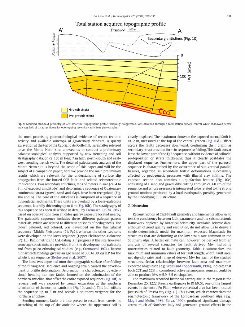
Fig. 9. Modeled fault/fold geometry of Ccα structure: topographic profile, vertically exaggerated, was obtained through a total station survey, central white-shadowed sectorindicates lack of data; see figure for outcropping secondary anticlines photographs.
331F.A. Livio et al. / Tectonophysics 476 (2009) 320–335
the most promising geomorphological evidence of recent tectonicactivity and available outcrops of Quaternary deposits. A quarryexcavation at the top of the Capriano del Colle hill, hereinafter referredto as the Monte Netto site, allowed us to conduct a preliminarypalaeoseismological analysis, supported by new trenching and soilstratigraphy data, on ca. 150 m long, 7 m high, north–south and east–west trending trench walls. The detailed paleoseismic analysis of theMonte Netto site is beyond the scope of this paper and will be thesubject of a companion paper; here we provide the main preliminaryresults which are relevant for the understanding of surface slippropagation from the buried CCB fault, and related seismotectonicimplications. Two secondary anticlines, tens of meters in size (ca. 4 to9 m of exposed amplitude) and deforming a sequence of Quaternarycontinental strata (gravel, sand and clay), have been recognized (Fig.10a and b). The core of the anticlines is composed of a sequence offluvioglacial sediments. These units are overlaid by a loess–paleosolssequence, laterally thickening up to 6 m (Fig. 10b). The stratigraphy ofthis sequence has been described in detail by Cremaschi (1974, 1987)based on observations from an older quarry exposure located nearby.The paleosols sequence includes three different paleosol-parentmaterials, which are related to different episodes of pedogenesis. Theoldest paleosol, red colored, was developed on the fluvioglacialsequence (Middle Pleistocene (?); Fg2), whereas the other two soilswere developed on the loess sequence (Upper Pleistocene–Holocene(?); LL). Radiometric and OSL dating is in progress at this site, howeversome age constraints are provided from the development of paleosolsand from paleo-ethnological studies. (e.g., Cremaschi, 1974). Recentflint artifacts findings give us an age range of 300 to 30 kyr B.P. for thewhole loess sequence (Berlusconi et al., 2007).
The loess was deposited onto the topographic surface after foldingof the fluvioglacial sequence and ongoing strain caused the develop-ment of brittle deformation. Deformation is characterized by exten-sional bending-moment faults, formed on the culmination of thenorthern anticline, that offset the entire exposed sequence (Fig. 10f). Areverse fault was exposed by trench excavation at the southerntermination of the northern anticline (Fig. 10b and c). This fault offsetsthe sequence up to 3 m and reveals a southern vergence for thenorthern anticline.
Bending moment faults are interpreted to result from coseismicstretching of the top of the anticline where the uppermost soil is
clearly displaced. The maximum throw on the exposed normal fault isca. 2 m, measured at the top of the central graben (Fig. 10d). Offsetacross the faults decreases downward, confirming their origin assecondary structures that form in response to folding. This fault cuts atleast the lower part of the Fg2 sequence, without evidence of colluvialre-deposition or strata thickening thus it clearly postdates thedisplaced sequence. Furthermore, the upper part of the paleosolsequence is characterized by the occurrence of sub-vertical parallelfissures, regarded as secondary brittle deformations successivelyaffected by pedogenetic processes with illuvial clay infilling. Theexposed section also contains a liquefaction feature (Fig. 10e)consisting of a sand and gravel dike cutting through ca. 60 cm of thesequence andwhose presence is interpreted to be related to the strongground motions produced by a local earthquake, possibly generatedby the underlying CCB structure.
7. Discussion
Reconstruction of CapFS fault geometry and kinematics allow us totest the consistency between fault parameters and the seismotectonicframework depicted by historical seismicity. Available seismic data,although of good quality and resolution, do not allow us to derive asingle deterministic model for maximum expected Magnitude forstructures that are deforming at the low strain rate common in theSouthern Alps. A better estimate can, however, be derived from ananalysis of several scenarios for fault derived Mw, includinguncertainties related to fault geometry. Table 1 summarizes themaximum and minimum values of for fault length, width, fault area,net dip-slip rates and range of derived Mw for each of the studiedstructures. Scalar relationships between fault area and maximumexpected Magnitude (e.g. Wells and Coppersmith, 1994), indicate thatboth CCT and CCB, if considered active seismogenic sources, could beable to produce Mw=5.9–6.5 earthquakes.
The maximum recorded historical earthquake in the region is theDecember 25, 1222 Brescia earthquake Io IX MCS), one of the largestevents in the entire Po Plain, whose epicentral area has been locatedjust south of Brescia city (Fig. 11). This event, which characterizes theseismotectonic framework of the Lombardian Southern Alps (e.g.,Magri and Molin, 1986; Serva, 1990), produced significant damageacross much of Northern Italy and generated ground effects in the

Fig.10. (a)Western quarry wall on the top of Capriano del Colle hill. Location is shown on Fig. 7b; (b) detail on the sector between northern and southern anticline, location of the trench represented in (c) is also shown; (c) eastern trench wallexcavated at the quarry floor: a high angle reverse fault, also indicated in (b), has been documented; (d) detail of the bending-moment normal faults affecting the upper part of the sequence: note the progressively downward decrease in offsetof normal faults; (e) detail on the identified liquefaction feature: a sand and gravel dike, ca. 80 cm high, and an associated flame-like secondary deformation affecting the overlying light brown clays; (f) structural data of the northern anticlineoutcrop: fold limb, fractures and faults are indicated. Calculated paleo-stress (after Tucker, 1951) documents a σ1 principal stress almost vertical and a σ3 stress, directed N190. Abbreviation are: Fg2, Upper Fluvioglacial sequence (MiddlePleistocene ?), LL, Loess deposits (Middle to Late Pleistocene?).
332F.A
.Livioet
al./Tectonophysics
476(2009)
320–335

Table 1Geometric and seismotectonic characteristics of the studied faults; minimum andmaximum values are indicated.
Fault name W (Km) L (Km) Area (km2) Slip (mm/yr)a Mwb
CCT 3.5–10.5 20–23 70–242 0.04 5.9–6.4CCB 8–11.6 20–30 160–348 0.43 6.2–6.6
aAverage slip rate is considered over the most recent time interval (0.89 Myr–present,see Fig. 6).bDerived from empirical regression between Subsurface rupture area and Mw (Wellsand Coppersmith, 1994).
333F.A. Livio et al. / Tectonophysics 476 (2009) 320–335
epicentral area such as sudden river deviations and ground cracks(Guidoboni, 1986; Boschi et al., 2000; Guidoboni and Comastri, 2005).No direct association can presently be demonstrated between CapFSstructures and the Christmas 1222 event, notwithstanding the highquality subsurface information available and analyzed in this study.
Fig.11. (a)Macroseismicmap of the December 25,1222 Brescia earthquake derived from poingrey dots; (b) detail of the macroseismic field compared with a digital elevation model of t
The tectonic source of this earthquake still remains questionable butsome important observations can be summarized as follows:
– The CCB structure is located beneath the epicentral area of theearthquake (Fig. 10b) as well as the CastFS north-verging thrust(Fig. 2a); they both belong to the same structural front and showsimilar structural architecture.
– The Macroseismic field shows an almost ENE–WSW major axis,consistent with the average trend of the buried structures (Fig. 11).
– Intensity derived Magnitude for the Dec. 25, 1222 event is Me=6.2(Guidoboni and Comastri, 2005). This estimate is also in goodagreementwith thedistributionofMagnitudevalues foreach Intensityclass, based on an extensive catalogue in the Mediterranean region(D'Amico et al.,1999).Mean value for Intensity (MCS) IX isMs 6.2, in arange between 5.8 and 6.7. All these estimates are comparable withCCBseismogenic sourcecharacteristics (ca.Mw=6.2–6.6, seeTable1).
t data published by Guidoboni and Comastri (2005). Intensity data are indicated as lighthe area and the surface projection of main buried structures.

334 F.A. Livio et al. / Tectonophysics 476 (2009) 320–335
– Surface environmental effects for such strong earthquakes usuallyinclude fracturing, surface displacement and liquefaction features(Serva, 1994; Guerrieri and Vittori, 2007). Features observed inCapriano del Colle site are consistent with such effects and withthose quoted for the Christmas 1222 event (Guidoboni andComastri, 2005). In particular surface deformation has beeninterpreted as due to secondary flexural-slip faulting, as observedfor the CCB structure.
– CapFS and adjacent structures (i.e. CastFS, to the east, see Fig. 2a)are characterized by similar fault geometry and Quaternary upliftrates (Livio et al., 2009). Deformation rates in the order offractions of a mm per year are consistent with the earthquakesize, slip per event and recurrence interval displayed by Christmas1222-like earthquakes, regarded as the maximum historicalearthquake experienced by the northern Po Plain (e.g., Serva,1990; see the empirical relations presented in Slemmons andDePolo, 1986).
– Repeated 1222-like earthquakes occurred during the Late Qua-ternary in this area would have produced a cumulative observableeffect of coseismic surface deformation and faulting, i.e., a specificseismic landscape (Michetti et al., 2005). The observations atCapriano del Colle site are consistent with this hypothesis.
8. Conclusions
This study defines the growth and seismic hazards posed by blindthrusts in the Po Plain using interpretation and structural analysis ofseismic data, geomorphological analysis of rivers and trench-scaleexcavations of active folds and faults. A structural solution andgeomorphic evidence are consistent with a deformation model thatimplies progressive kink-band widening above faults characterized bycurved fold hinges. Bedding parallel faults, formed near the surface,play an important role in accommodating folding and induce surficialdeformation, where no primary surface faulting has to be expected.This finding has primary importance for the identification of capablefaults (sensu IAEA, 2002;Michetti et al., 2005) in active compressionaltectonic environments and for surface faulting hazard evaluation inthe Po Plain, particularly as related to siting and seismic design ofcritical facilities. The reconstruction of Quaternary tectono-sedimen-tary history of CapFS structures, based on geophysical data, demon-strates that both the CCB and CCT are active at least up to MiddlePleistocene time. Geomorphological data and our preliminary analysison outcrops of folded strata probably record active strain during LatePleistocene time. Work is in progress to obtain a complete dating ofthe Capriano del Colle quarry sequence through OSL and AMSanalyses. Earthquake scenarios depicted for CapFS faults seismicpotential (Mw=5.9–6.6) are consistent with the known northern PoPlain seismotectonic framework and historical seismicity. From adeterministic point of view, an earthquake of similar energy couldrepresent a serious hazard and cause significant losses in such adensely populated area as the Northern Italy.
Nevertheless in recent seismic hazard analyses and seismogenicfault compilations (Basili et al., 2008; Meletti et al., 2008) thesestructures have not been adequately taken into account and theirmeaning in terms of seismic potential haven't been considered. Thisunderlines the primary role that geological and paleoseismologicaldata should play in the understanding of earthquake hazard,especially in regions characterized by moderate seismicity and lowstrain rates.
Acknowledgments
We thank the municipality of Capriano del Colle, Brescia Provinceadministration and in particular Fornaci Laterizi Danesi S.p.A. forpermission to site access and trenching. Also F.lli Arici S.r.l. is thankedfor logistic support. Special thanks to F. Storti, G. Roberts and an
anonymous reviewer for their constructive suggestions and criticisms,which greatly improved the manuscript. This research has benefitedfrom funding provided by the Italian Presidenza del Consiglio deiMinistri – Dipartimento della Protezione Civile (DPC). Scientificpapers funded byDPC do not represent its official opinion and policies.
References
Allmendinger, R.W., 1998. Inverse and forward numerical modelling of trishear fault-propagation folds. Tectonics 17, 640–656.
Allmendinger, R.W., Shaw, H., 2000. Fault nucleation and propagation from fold shape:potential implications for earthquake seismicity. Geology (28), 1099–1102.
Baroni, C., Cremaschi, M., 1986. Geologia e pedostratigrafia della Collina di Ciliverghe(Brescia). Nat. Brescia., Ann. Mus. Civ. Sci. Nat. 23, 55–78.
Basili, R., Valensise, G., Vannoli, P., Burrato, P., Fracassi, U., Mariano, S., Tiberti, M.M.,Boschi, E., 2008. The Database of Individual Seismogenic Sources (DISS), version 3:summarizing 20 years of research on Italy's earthquake geology. Tectonophysics453 (1–4), 20–43 16.
Benedetti, L., Tapponier, P., King, C.P.G., Meyer, B., Manighetti, I., 2000. Growth foldingand active thrusting in the Montello region, Veneto, Northern Italy. J. Geophys. Res.105 (B1), 739–766.
Berlusconi, A., Livio, F., Sileo, G., Zerboni, A., Michetti, A.M., Cremaschi, M., Trombino, L.,2007. Evidenze paleosismiche nell'area epicentrale del terremoto del 25.12.1222:risultati preliminari. GruppoNazionale di Geofisica della Terra Solida – 26 CongressoNazionale – 13–15 Novembre 2007. – Roma, pp. 238–241.
Bernoulli, D., Bertotti, G., Zingg, A., 1989. Northward thrusting of the GonfoliteLombarda (“South-Alpine Molasse”). Eclogae Geol. Helv. 82, 841–856.
Bernoulli, D., Gunzenhauser, B., 2001. A dolomitized diatomite in an Oligocene–Miocenedeep-sea fan. Sediment. Geol. 139 (1), 71–91.
Bertotti, G., Capozzi, R., Picotti, V., 1997. Extensions controls, Quaternary tectonics,geomorphology and sedimentation of the N-Appennines foothills and adjacent PoPlain (Italy). Tectonophysics (282), 291–301.
Boni, P., Peloso, G.F., 1982. Dati sulla neotettonica dei fogli 34 qBrenoq, 47 qBresciaq e diparte dei fogli 35 qRivaq e 48 qPeschieraq. Vol. pubbl. 506 – P.F. Geodinamica, inContributi conclusivi per la realizzazione della Carta Neotettonica d'Italia., di CNR,pp. 189 – 208.
Boschi, E., Guidoboni, E., Ferrari, G., Mariotti, D., Valensise, G., Gasperini, P., 2000. Catalogueof strong Italian earthquakes from 461 B.C. to 1997. Ann. Geofis. 43, 609–868.
Burbank, D., Meigs, A., Brozovic, N., 1996. Interactions of growing folds and coevaldepositional systems. Basin Res. (8), 199–223.
Burrato, P., Ciucci, F., Velensise, G., 2003. An inventory of river anomalies in the Po Plain,Northern Italy: evidence for active blind thrust faulting. Ann.Geophys. 46 (5), 865–882.
Carcano, C., Piccin, A. (a cura di), 2002. Geologia degli acquiferi Padani della RegioneLombardia. Firenze: S.EL.CA.
Castaldini, D., Panizza, M., 1991. Inventario delle faglie attive tra i fiumi Po e Piave e ilLago di Como (Italia settentrionale). Il Quaternario 4 (2), 333–410.
Castellarin, A., Vai, G.B., 1986. Southalpine versus Po Plain Apeninic Arcs. In: Weizel, C.(Ed.), The origin of Arcs. Elsevier Science Publisher B.V., Amsterdam, pp. 253–280.
Castellarin, A., Cantelli, L., 2000. Neo-Alpine evolution of the Southern Eastern Alps.J. Geodyn. 30, 251–274.
Castellarin, A., Transalp Working Group, 2004. Structural syntesis of the Eastern Alps: acollisional orogenic chain. In: d'Offizi, F., Merlino, S., Sacchi, L., Crescenti, V. (Eds.),Geology of Italy – Special Volume of the Italian Geological Society for the IGC 32Florence 2004, pp. 3–13.
Castellarin, A., Vai, G.B., Cantelli, L., 2006. The Alpin evolution of the Southern Alpsaround the Giudicarie faults: a Late Crataceous to Early Eocene transfer zone.Tectonophysics 414, 203–223.
Champion, J., Mueller, K., Tate, A., Guccione, M., 2001. Geometry, numerical models andrevised slip rate for the Reelfoot fault and trishear fault-propagation fold, NewMadrid seismic zone. Eng. Geol. 62, 31–49.
Chen, Y.G., Lai, K.Y., Lee, Y.H., Suppe, J., Chen,W.S., Lin, Y.N.N.,Wang, Y., Hung, J.H., Kuo, Y.T.,2007. Coseismic fold scarps and their kinematic behavior in the 1999 Chi-Chiearthquake Taiwan. J. Geophys. Res. 112, B03S02. doi:10.1029/2006JB004388 2007.
Chunga, K., Livio, F., Michetti, A.M., Serva, L., 2007. Synsedimentary deformation ofPleistocene glaciolacustrine deposits in the Albese con Cassano Area (SouthernAlps, Northern Italy), and possible implications for paleoseismicity. SedimentaryGeology 196 (1–4), 59–80.
Cita, M.B., 1982. The Messinian salinity in the Mediterranean: a review. In: Berkhemer,E., Hsu, K.J. (Eds.), Alpine-Mediterranean Geodynamics. Geodynamics Series, vol. 7.
Cita, M.B., Wright, R.C., 1979. Geodinamic and Byodinamic Effects of theMessinian Crisisof Salinity. Paleogeogr., Paleoclimat., Paleoecol., vol. 29. Spec. Issue.
Cita, M.B., Bini, A., Corselli, C., 1990. Superfici di erosione messiniana: un'ipotesisull'origine dei laghi sudalpini. Il lago Maggiore dalla ricerca alla gestione.Documento dell'Istituto Italiano di Idrobiologia, vol. N.22, pp. 33–54.
CPTI, 2004. Catalogo Parametrico dei Terremoti Italiani, versione 2004 (CPTI04). INGV,Bologna. http://emidius.mi.ingv.it/CPTI/.
Cremaschi, M., 1974. Manufatti del Paleolitico medio – inferiore, provenienti da MonteNetto di Brescia e loro rapporti con i depositi quaternari del Colle. Nat. Brescia. –Ann. Mus. Civ. Stor. Nat. Brescia. 11, 41–57.
Cremaschi, M., 1987. Paleosol and Vetusols in the Central Po Plain (Northern Italy) astudy in Quaternar geology and soil development. Edizioni Unicopli, Milano.
Curzi, P.V., Castellarin, A., Ciabatti, M., Badalini, G., 1992. Caratteri morfostrutturali,sedimentologici e genetici del Lago di Garda. Boll. Soc. Torricelliana di Scienze eLettere 43, 3–111.

335F.A. Livio et al. / Tectonophysics 476 (2009) 320–335
D'Amico, V., Albarello, D., Mantovani, E., 1999. A distribution-Free analysis of magnitude–intensity relationships; an application to theMediterranean region. Phys. Chem. EarthPart A: Solid Earth Geod. 24 (6), 517–521.
de Polo, C., Clark, D., Slemmons, D., A.R., R., 1991. Historical surface faulting in the Basinand Range province, western North America: implications for fault segmentation.J. Struct. Geol. 13, 123–136.
Desio, A., 1965. I rilievi isolati della Pianura Lombarda ed i movimenti tettonici delQuaternario. Rend. Ist. Lomb. Acc. Sci. Lett., Sez. A 99, 881–894.
Dolan, J.F., Christofferson, S.A., Shaw, J.H., 2003. Recognition of Paleoearthquakes on thePuenteHills Blind Thrust Fault, California. Science 300, 115.
Erslev, E.A., 1991. Trishear fault-propagation folding. Geology 19, 617–620.Fantoni, R., Bersezio, R., Forcella, F., 2004. Alpine structure and deformation chronology
at the Southern Alps–Po Plain border in Lombardy. Boll. Soc. Geol. Ital.123, 463–476.Gelati, R., Napolitano, A., Valdisturlo, A., 1988. La gonfolite lombarda; stratigrafia e
significato nell' evoluzione del margine Sudalpino Lombardo. Riv. Ital. Paleontol.Stratigr. 94 (2), 285–332.
Gelati, R., Napolitano, A., Valdisturlo, A., 1991. Results of studies one the Meso-Cenozoicsuccession in the Monte Olimpino 2 tunnel. The tectono-sedimentary significanceof the “Gonfolite Lombarda”. Riv. Ital. Paleontol. Stratigr. III–IV (97), 565–598.
Geyh, A., Schleicher, H., 1990. Absolute Age Determination. Springer-Verlag, Berlin.Gianotti, R., Perotti, C.R., 1987. Introduzione alla tetonica e all'evoluzione strutturale
delle Alpi Lariane. Mem. Soc. Geol. Ital. (32), 67–99.Guerrieri, L., & Vittori, E.(Editors), 2007. Intensity Scale ESI 2007. Mem. Descr. Carta
Geologica d'Italia, 74, Servizio Geologico d'Italia, Dipartimento di Defesa del Suolo,APAT, Rome, Italy.
Guidoboni, E., 1986. The earthquake of December 25th, 1222: analysis of a myth. Geol.Appl. Idrogeol. 21, 413–424.
Guidoboni, E., Comastri, A. (editors), 2005. Catalogue of earthquakes and tsunamis inthe Mediterrean area from the 11th to the 15th century. vol. II, INGV IstitutoNazionale di Geofisica e Vulcanologia & SGA Storia Geofisica e Ambiente S.r.l.,Bologna, 950 p.
Hardy, S., Ford, M., 1997. Numerical modeling of trishear fault-propagation folding andassociated growth strata. Tectonics 16, 841–854.
IAEA, 2002. Evaluation of Seismic Hazards for Nuclear Power Plants. IAEA SafetyStandard Series, Vienna. No. NS-G-3.3.
Ishiyama, T., Mueller, K., Togo, M., Okada, A., Takemura, K., 2004. Geomorphology,kinematic history, and earthquake bahavior of the active Kuwana wedge thrustanticline, central Japan. J. Geophys. Res. (109), B12408.
Lai, K., Chen, Y., Hung, J., Suppe, J., Yue, L., Ya-Wen Chen, Y., 2006. Surface deformationrelated to kink-folding above an active fault: evidence from geomorphic featuresand co-seismic slips. Quat. Int. 147, 44–54.
Leon, L.A., Christofferson, S.A., Dolan, J.F., Shaw, J.H., Pratt, T.L., 2007. Earthquake-by-earthquake fold growth above the Puente Hills blind thrust fault, Los Angeles,California: implications for fold kinematics and seismic hazard. J. Geophys. Res. 112,B03S03. doi:10.1029/2006JB004461.
Lin, J., Stein, R.S., 2006. Seismic constraints and Coulomb stress changes of a blind thrustfault system. 1: Coalinga and Kettleman Hills, California, USGS Open-File Report2006-1149, 17 P.
Livio, F., Michetti, A.M., Sileo, G., Carcano, C., Mueller, K., Rogledi, S., Serva, L., Vittori, E.,Berlusconi, A., 2009. Quaternary capable folds and seismic hazard in Lombardia(Northern Italy): the Castenedolo structure near Brescia. It. Journ. Geosc. Boll. Soc.Geol. It. 128, 191–200.
Magri, G., Molin, D., 1986. I terremoti del 3 Gennaio 1117 e del 25 Dicembre 1222. ENEA-RTI-PAS-ASPGEOL-LO, 2.
Marchetti, M., 1996. Variazioni idrodinamiche dei corsi d'acqua della Pianura Padanacentrale connesse con la deglaciazione. Il Quaternario 9, 465–472.
Masaferro, J.L., Bulnes, M., Poblet, J., Eberli, G.P., 2002. Episodic folding inferred fromsyntectonic carbonate sedimentation: the Santaren anticline, Bahamas foreland.Sediment. Geol. 146, 11–24.
McClay, K., 1992. Glossary of thrust tectonics terms.» In Thrust tectonics, di K. McClay,pp.419–433. Chapman & Hall, London.
Medwedeff, D.A.,1992. Geometry and kinematics of an active, laterally propagatingwedgethrust,Wheeler Ridge, California. In: Fisher, S.,Mitra, G.W. (Eds.), StructuralGeologyofFold and Thrust Belts. Jhon Hopkins University Press, Baltimore, Md., pp. 3–28.
Medwedeff, D.A., Suppe, J., 1997. Multibend fault-propagation folding. J. Struct. Geol. 19,279–292.
Meletti, C., Galadini, F., Valensise, G., Stucchi,M., Basili, R., Barba, S., Vannucci, G., Boschi, E.,2008. A seismic source zone model for the seismic hazard assessment of the Italianterritory. Tectonophysics 450 (1–4), 85–108 1.
Michetti, A.M., Audemard, F.A., Marco, S., 2005. Future trends in paleoseismology:Integrated study of the seismic landscape as a vital tool in seismic hazard analysis.Tectonophysics 408, 3–21.
Mirzaei, N., Gao, M., Chen, Y., 1999. Delineation of potential seismic sources for seismiczoning of Iran. J. Seismol. (32), 17–39.
Mueller, K., Suppe, J., 1997. Growth of Wheeler Ridge anticline, California: geomorphicevidence for fault-bend folding behavior during earthquakes. J. Struct. Geol. (19),383–396.
Muttoni, G., Carcano, C., Garzanti, E., Ghielmi,M., Piccin, A., Pini, R., Rogledi, S., Sciunnach,D., 2003. Onset of major Pleistocene galciations in the Alps. Geology 31 (11),989–992.
Nino, F., Philip, H., Chery, J., 1998. Role of bed-parallel slip in th formation of blinf thrustfaults. J. Struct. Geol. (20), 503–516.
Ouchi, S., 1985. Response of alluvial rivers to slow active tectonic movements. Geol. Soc.Am. Bull. 96, 504–515.
Ravaglia, A., Seno, S., Toscani, G., Fantoni, R., 2006. Mesozoic extension controlling theSouthern Alps thrust front geometry under the Po Plain, Italy: Insights from sandboxmodels. J. Struct. Geol. 28, 2048–2096.
Roering, J.J., Cooke, M.L., Pollard, D.D., 1997. Why blind thrust faults do not propagate tothe Earth's surface: numerical modeling of coseismic deformation associated withthrsuts related anticlines. J. Geophys. Res. 102, 11901–11912.
Rossi, M., Rogledi, S., 1988. Relative sea-level changes, local tectonic settings and basinmargin sedimentation in the interference zone between two orogenic belts: sesmicstratigraphyexamples fromPadan forelandbasin, northern Italy. In:Nemec,W., Steel,R.(Eds.), Fan Deltas: Sedimentology and Tectonic Settings. Blackie & Sons, pp. 368–384.
Scardia, G., Muttoni, G., Sciunnach, D., 2006. Subsurface magnetostratigraphy ofPleistocene sediments from the Po Plain (Italy): constraints on rates of sedimentationand rock uplift. GSA Bull. 118 (11/12), 1299–1312.
Sciunnach, D., Tremolada, F., 2004. The Lombardian Gonfolite Group in the centralBrianza (Como and Milnao Provinces, Italy): calcarous nannofossil biostratigraphyand sedimentary record of neo-alpine tectonics. Eclogae Geol. Helv. 1 (97), 119–131.
Serpelloni, E., Anzidei, M., Baldi, P., Casula, G., Galvani, A., 2005. Crustal velocity andstrain rate fields in Italy and surrounding regions; new results from analysis ofpermanent and non-permanent GPS networks. Gephys. J. Int. 161 (3), 861–880.
Serva, L.,1990. Il ruolo delle Scienzedella terra nelle analisi di sicurezzadiunsitoper alcunetipologie di impianti industriali; il terremoto di riferimento per il sito di Viadana (MN).Boll. Soc. Geol. Ital. 109, 375–411.
Serva, L., 1994. Ground effects in the intensity scales. Terra Nova 6, 414,416.Shaw, J.H., Suppe, J., 1994. Active faulting and growth folding in the eastern Santa
Barbara channel, California. Bull. Geol. Soc. Am. 106, 607–626.Shaw, J.H., Suppe, J., 1996. Earthquake hazards of active blind thrust faults under the
Central Los Angels basin, California. J. Geophys. Res. (101), 8623–8642.Shaw, J.H., Plesch, A., Dolan, J.F., Pratt, T.L., Fiore, P., 2002. Puente Hills blind-thrust
systems, Los Angeles, California. Bull. Seismol. Soc. Am. (92), 2946–2960.Sileo, G., Giardina, F., Livio, F., Michetti, A.M., Mueller, K., Vittori, E., 2007. Remarks on the
Quaternary tectonics of the Insubria Region (Lombardia, NW Italy, and Ticino, SESwitzerland). It. J. Geosc. Boll. Soc. Geol. It. 126 (2), 411–425.
Slemmons, D.B., DePolo, C.M., 1986. Evaluation of active faulting and associated hazard.In: Wallace, R.E. (Ed.), Active Tectonics. National Academy Press, Washington D.C.,pp. 45–62.
Streig, A.R., Rubin, C.M., Chen,W.S., Chen, Y.G., Lee, L.S., Thompson, S.C.,Madden, C., Lu, S.T.,2007. Evidence for prehistoric coseismic folding along the Tsaotun segment of theChelungpu fault near Nan-Tou, Taiwan. J. Geophys. Res. 112, B03S06. doi:10.1029/2006JB004493.
Suppe, J., 1983. Geometry and kinematics of fault bend folding. Am. J. Sci. 283, 684–721.Suppe, J., Medwedeff, D.A., 1990. Geometry and kinematics of fault-propagation folding.
Eclogae Geol. Helv. 83, 409–454.Suppe, J., Chou, G.T., Hook, S.C.,1992. Rates of folding anf faulting determined from growth
strata. In: McClay, K. (Ed.), Thrust Tectonics. Chapman & Hall, London, pp. 105–120.Suppe, J., Sabat, F., Munoz, A., Poblet, J., Roca, E., Verges, J., 1997. Bed-by-bed growth by
kink band migration: Sant Llorenc de Morunys, Eastern Pyrenees. J. Struct. Geol. 19,443–461.
Suppe, J., Connors, C., Zhang, Y., 2004. Shear fault-bend folding. In K. Mc Clay, Thrusttectonics and hydrocarbon systems. AAPG Mem. 82, 303–323.
Tavani, S., Storti, F., Salvini, F., 2005. Rounding hinges to fault.bend folding: geometricand kinematic implications. J. Struct. Geol. 27, 3–22.Vittori, E., 2004. The map ofcapable faults of Italy. Int. Geol. Cong. Florence vol. 32, 20–28 August, 2004. Firenze,2004.
Vittori, E., 2004. The map of capable faults of Italy [Atti di convegno] // 32th Int. Geol.Cong. Florence, 20–28 August, 2004.
Wells, D.L., Coppersmith, K.J., 1994. New empirical relationship among Magnitude,rupture length, rupturewidth, rupture area and surface displacement. Bull. Seismol.Soc. Am. 84, 974–1002.
Winterer, E.L., Bosellini, A., 1981. Subsidence and sedimentation on a Jurassic passivecontinental margin (Southern Alps, Italy). A.A.P.G. Bull. 65, 394–421.
Yeats, R.S., 1986. Active faults related to folding. In: Wallace, R.E. (Ed.), Active Tectonics.National Academy Press, Washington, pp. 63–79.