Acronyms - earthresources.vic.gov.au€¦ · Web viewReasonable changes to Victoria’s planning...
54
Strategic Extractive Resource Areas Victoria’s Existing Planning System October 2016
Transcript of Acronyms - earthresources.vic.gov.au€¦ · Web viewReasonable changes to Victoria’s planning...

Strategic Extractive Resource Areas
Victoria’s Existing Planning System
October 2016

Executive summaryThis report provides Minerals Development Victoria (MDV) with an explanation of the current Victorian planning system with respect to the protection of extractive resources and establishes a conceptual definition of ‘strategic extractive resource areas’ (SRAs). The report demonstrates how the incorporation of these areas into the existing planning system can provide for the efficient approval of stone extraction and long term protection of Victoria’s stone resources.
Stone extraction is critical to society as a whole, with extractive industry products used in housing, commercial and industrial buildings and key infrastructure. To ensure materials are affordable and accessible now and into the future, it is essential that high quality sand and stone resources in proximity to markets remain available for extraction. The importance of extractive industry to Victoria is recognised in the State Planning Policy Framework (SPPF) of Victoria’s planning schemes. However in some cases, extractive industry has been compromised by competing land use activities with resultant impacts to operations, and in some places, the extraction of resources has been forced to cease prematurely. In addition, the development of new projects is subject to complex and often lengthy approval processes under the Planning and Environment Act 1987 (the Act) and the Mineral Resources (Sustainable Development) Act 1990 (MRSDA). The interrelationship between the Act and the MRSDA is often poorly understood by responsible authorities. These land use planning issues were identified and considered in detail by the Parliament of Victoria in 1994 with the Environment and Natural Resources Committee’s Report on Planning Issues for Extractive Industries and the Economic Development and Infrastructure Committee’s Inquiry into greenfields mineral exploration and project development in Victoria in 2012.
Key to this report is the development of a conceptual definition of SRAs. The report defines SRAs as:
A defined area with a significant stone resource. It has manageable environmental and planning constraints and is accessible to markets.
This definition builds on the definition put forward by PWC in Extractive Resources in Victoria: Demand and Supply Study 2015-2059 (PWC 2016). It applies the earlier definition in the land use planning context, to accurately reflect the strategic importance of a stone resource and to provide greater certainty surrounding the development of stone resources. This report identifies that meaningful changes would need to be made to Victoria’s planning system to achieve this outcome.
The report proposes to apply SRAs to areas which are currently producing stone which is in high demand or of unique importance to Victoria. These areas can be identified by a number of contiguous or proximate operating and proposed work authorities. Additionally, SRAs should be developed to protect important stone resources to ensure their availability well into the future (2050 and beyond).
A future body of work will be required to prepare detailed criteria for the selection and establishment of SRAs as defined areas. Once defined, a series of state-wide amendments to the Victoria Planning Provisions and amendments to planning schemes will be required to highlight the policy importance of SRAs and to clearly identify them within planning schemes by using a number of existing planning scheme zone and overlay provisions.
This report highlights the need for SRAs to be clearly recognised within planning scheme maps and to be supported by the development of appropriate planning scheme ordinance. Specifically this report suggests that SRAs be incorporated into planning schemes as follows:
For SRAs over production clusters:
- Relevant changes to the State Planning Policy Framework
- Application of the Special Use Zone over existing and proposed Work Authorities and preparation of a new extractive industry schedule, and
- Application of the Environmental Significance Overlay beyond the Special Use Zone to identify the required buffer area.
For SRAs over long term resources:
i

- Relevant changes to the State Planning Policy Framework, and
- Application of the State Resource Overlay.
This report also recommends that stone extraction in Victoria (irrespective of its inclusion within a SRA) would be greatly assisted by the introduction of a planning permit trigger (within the suite of existing rural zones) for sensitive uses (dwellings, accommodation, education facilities and childcare facilities) which are proposed to be established within 500 metres of a Work Authority or proposed Work Authority.
ii

ContentsExecutive summary.............................................................................................................................................. iAcronyms............................................................................................................................................................. v1. Introduction.............................................................................................................................................. 11.1 Purpose of this report................................................................................................................................. 1
1.2 Importance of stone extraction................................................................................................................... 1
1.3 Remaining challenges in protecting resources..........................................................................................2
2. Extractive industry and Victoria’s Planning System............................................................................42.1 Planning and Environment Act 1987..........................................................................................................5
2.2 Planning schemes..................................................................................................................................... 5
2.2.1 State Planning Policy Framework..............................................................................................................6
2.2.2 Local Policy Planning Framework..............................................................................................................7
2.2.3 Zones......................................................................................................................................................... 8
2.2.4 Overlays..................................................................................................................................................... 9
2.2.5 Particular provisions................................................................................................................................. 12
2.2.6 General provisions................................................................................................................................... 13
2.2.7 Incorporated and reference documents...................................................................................................13
3. Assessing permit applications for stone extraction...........................................................................153.1 Background.............................................................................................................................................. 15
3.2 Approvals process................................................................................................................................... 15
4. Other assessments and extractive industry........................................................................................184.1 Environment Protection and Biodiversity Conservation Act 1999 (C’wealth)...........................................18
4.2 Environment Effects Act 1978.................................................................................................................. 18
4.3 Aboriginal Heritage Act 2006................................................................................................................... 18
4.4 Other consents and approvals................................................................................................................. 19
5. Strategic resource areas....................................................................................................................... 205.1 Strategic resource determination.............................................................................................................20
5.2 Strategic resource areas.......................................................................................................................... 21
5.3 Scenarios................................................................................................................................................. 23
5.3.1 Production clusters.................................................................................................................................. 23
5.3.2 Long term resource areas........................................................................................................................ 24
5.3.3 Important quarries outside of SRAs.........................................................................................................25
5.4 Options for Victoria’s Planning System....................................................................................................25
5.5 Suggested approach................................................................................................................................ 27
5.5.1 Amendments to Planning Schemes.........................................................................................................27
5.6 The Planning Scheme Amendment process............................................................................................30
5.6.1 General process...................................................................................................................................... 30
6. Conclusion and recommendations......................................................................................................33References......................................................................................................................................................... 35
Appendix A. Required Special Use Zone schedule
iii

Appendix B. ZonesAppendix C. Schedules to the Environmental Significance OverlayAppendix D. State Resource Overlay and scheduleAppendix E. Clause 52.08Appendix F. Clause 52.09
iv

AcronymsTerm / Acronym Description
BCA Building Code of Australia
CHMP Cultural Heritage Management Plan
DEDJTRDepartment of Economic Development, Jobs, Transport and Resources (formally the Department of State Development, Business and Innovation (DSDBI))
DELWPDepartment of Environment, Land, Water and Planning (formally the Department of Planning and Community Development and previous to this, Department of Sustainability and Environment)
DoE Commonwealth Department of the Environment
EE Act Environment Effects Act 1978 (Vic)
EES Environment Effects Statement
EIIA Extractive Industry Interest Area
EP Act Environment Protection Act 1970 (Vic)
EPBC Act Environment Protection and Biodiversity Conservation Act 1999 (Cth)
FFG Act Flora and Fauna Guarantee Act 1988 (Vic)
LPPF Local Planning Policy Framework
MDV Minerals Development Victoria
MRSDA Minerals Resources (Sustainable Development) Act 1990 (Vic)
MSS Municipal Strategic Statement
NES National Environmental Significance
P&E Act Planning and Environment Act 1987 (Vic)
SRA Strategic Extractive Resource Area
SPPF State Planning Policy Framework
VCAT Victorian Civil and Administrative Tribunal
VPP Victoria Planning Provisions
v

1. Introduction1.1 Purpose of this report
The purpose of this report is to provide Minerals Development Victoria (MDV) with an explanation of the Victorian planning system with respect to the protection of extractive resources. In addition, this report establishes a conceptual definition of ‘Strategic Extractive Resource Areas’ (SRAs) and considers options for incorporating these areas into Victoria’s planning system.
Chapters 2, 3 and 4 of this report describe Victoria’s current planning system (and associated legislation). These sections discuss how the planning system currently identifies, protects and ultimately facilitates the exploitation of extractive resources using the Victoria Planning Provisions (VPPs).
Chapter 5 of the report establishes a conceptual definition of SRAs and reviews the existing tools within the VPPs that could be used to give effect to the greater protection of stone resources. Chapter 5 also considers opportunities to facilitate the approval of stone extraction where located within SRAs.
1.2 Importance of stone extraction
Victoria has in the order of 485 quarries which produce around 40 million tonnes of stone annually (DEDJTR 2016). The value of this production at the ‘quarry gate’ is estimated to be around $676 m annually (DEDJTR 2016).
Extractive industries are critical to society as a whole as they provide the base materials used in housing, commercial and industrial buildings and key infrastructure such as roads, railways, wind farms, ports and bridges. To ensure that extractive industry materials are affordable and accessible now and into the future, it is essential that high quality sand and stone resources, that are in proximity to markets, remain available for extraction.
The importance of extractive industry to Victoria is recognised in Clause 14.03 of the State Planning Policy Framework (SPPF) of Victoria’s planning schemes and has recently been recognised in Extractive Resources in Victoria: Demand and Supply Study 2015-2059 (PWC 2016) and Demand Analysis of Extractive Resources in Victoria (EY 2016).
The impact of competing land uses on existing and proposed extractive industry has been recognised in parliamentary inquiries dating back to the Parliament of Victoria’s, Environment and Natural Resources Committee Report on Planning Issues for Extractive Industries (ENRC 1994) which noted that:
Sterilisation, or the prevention of extractive industry development by prior occupation of a site or a region by another land use, represents a major constraint imposed on future quarry developments. In particular, urban spread has sterilised, and has the potential to sterilise, large areas of stone resource, and that;
Subdivision of broadacre farming land and forested land into small allotments often described as "hobby farms" and "bush blocks". This process reduces the supply of land that is of a size sufficient to accommodate many "utility" land uses, including quarries.
The Government response to ENRC 1994 led to a number of changes to the then Victorian planning system, which remain in some form, including the:
Introduction of Extractive Industry Interest Areas and a State extractive industry policy
Creation of the then Department of Energy and Minerals (DEM) as a ‘notice authority’ for planning permit applications within Extractive Industry Interest Areas and a prescribed authority for all planning scheme amendments
Requirement for internal buffers within quarries to be owned or controlled by the quarry operator
Notification requirements to DEM of some planning permit applications within 500 m of an extractive industry
1
Linking of extractive industry planning permits to the life of the stone resource.
The Government response to ENRC 1994 also included measures which were not implemented or, which were subsequently removed from Victoria’s planning system, such as identifying Extractive Industry Interest Areas and extractive industry sites with an 'identifier' overlay on planning scheme maps.
The Victorian Parliament’s Economic Development and Infrastructure Committee Inquiry into greenfields mineral exploration and project development in Victoria (EDIC 2012) made three key recommendations to Government being:
That the Victorian Government develops a state-wide integrated, strategic land use policy framework to better manage competing land uses in Victoria. This framework should be subject to periodic review giving consideration to economic, social and environmental factors.
As part of the development of an integrated state-wide strategic land use framework, that the Victorian Government ensures studies are undertaken to determine areas of high prospectivity for extractives and future extractives needs in metropolitan Melbourne and regional Victoria.
That the findings of the extractives prospectivity and future needs studies be incorporated into the state-wide strategic land use framework, be protected in local planning schemes, and have appropriate post-extractive uses identified that are consistent with and sensitive to abutting areas.
The Government response to EDIC 2012 proposed to:
Ensure existing extractive industry interest areas are incorporated into the Regional Growth Plans
Where necessary, use the existing provisions under the Planning and Environment Act 1987 for the Minister for Energy and Resources to withhold consent for changes to planning schemes that may affect stone resources
Enable the Minister for Energy and Resources to become a referral authority for developments near existing quarries, and
Consider the most appropriate method to protect resources within the planning framework.
1.3 Remaining challenges in protecting resources
Despite the significant body of work undertaken by previous Parliaments and State Governments and the fact that the importance of extractive industry is recognised in Clause 14.03 of the SPPF, the sterilisation of stone resources by other land uses remains a concern for stone extraction. Identified resources have continued to be ‘sterilised’ by rural subdivision, proliferation of lifestyle properties and/or urban development. Additionally, established quarries which operate in accordance with their approvals, remain under pressure from encroaching incompatible land uses which have the potential to significantly hinder operations and to end extraction prior to the exhaustion of the stone resource.
A consistent challenge for operating quarries and key resource areas remains. That is, in most cases significant quarries and resource areas are not adequately identified by or protected by Victoria’s planning schemes. These areas are, in most instances not shown on planning scheme maps and, as a consequence, the protection resources are reliant on planning scheme policy1, obscure planning scheme ordinance2 and reference documents3.
Planning reform to appropriately protect stone extraction is overdue. PWC (2016) concluded that Victoria faces the potential of constrained future supply as a consequence of the issues mentioned. Given projected demand from forecast infrastructure projects and the continued challenge faced in maintaining access to quality extractive resources, the development of a suite of effective and efficient planning instruments will be important in securing the long term supply of stone resources for Victoria.
1 Clause 14.03 Resource exploration and extraction2 Clause 52.09-8 Stone Extraction and Extractive Industry Interest Areas - Notice of an application3 For example - Melbourne Supply Area - Extractive Industry Interest Areas Review -Geological Survey of Victoria Technical Record 2003/2.
2

Reasonable changes to Victoria’s planning system, largely using existing planning ‘tools,’ would ensure that existing quarries, significant stone production areas and strategic long term resources are adequately identified and protected from incompatible land uses.
The identification of SRAs against sound criteria would (in addition to earlier parliamentary inquiries, Extractive Industry Interest Areas and recent work by PWC and EY) provide the strategic justification for further reform to Victoria’s planning system. This would lead to enhanced protection of significant stone resources and for more timely decision making.
3

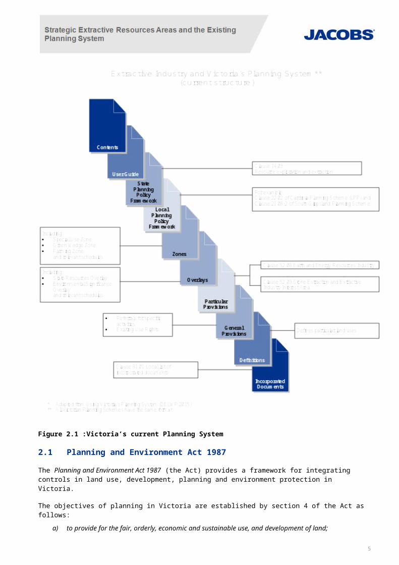
2. Extractive industry and Victoria’s Planning System The Mineral Resources (Sustainable Development) Act 1990 (MRSDA) provides the main legislative framework for extractive industry in Victoria. However, the Victorian planning system plays a key role in providing statutory weight to the location of the industry and its interface with other land uses. The development of new projects is often subject to complex and lengthy approval processes under the Planning and Environment Act 1987 (the Act) and the MRSDA.
Figure 2.1 shows the structure and components of Victoria’s current planning system and highlights where extractive industry is referenced in the planning system. This chapter discusses these components in further detail.
Figure 2.1 :Victoria’s current Planning System
4
2.1 Planning and Environment Act 1987
The Planning and Environment Act 1987 (the Act) provides a framework for integrating controls in land use, development, planning and environment protection in Victoria.
The objectives of planning in Victoria are established by section 4 of the Act as follows:
a) to provide for the fair, orderly, economic and sustainable use, and development of land;
b) to provide for the protection of natural and man-made resources and the maintenance of ecological processes and genetic diversity;
c) to secure a pleasant, efficient and safe working, living and recreational environment for all Victorians and visitors to Victoria;
d) to conserve and enhance those buildings, areas or other places which are of scientific, aesthetic, architectural or historical interest, or otherwise of special cultural value;
e) to protect public utilities and other assets and enable the orderly provision and co-ordination of public utilities and other facilities for the benefit of the community;
f) to facilitate development in accordance with the objectives set out in paragraphs (a), (b), (c), (d) and (e);
g) to balance the present and future interests of all Victorians.
The Act provides for planning schemes to be established and administered by local government to control the use and development of land. Planning schemes must seek to further the objectives of planning in Victoria within the area covered by the scheme and do this by setting out policies and provisions for the use, development and protection of land. These controls overlap with other Victorian legislation including, but not limited to, the Environment Protection Act 1970, Environment Effects Act 1978, Water Act 1989 and Subdivision Act 1988.
The Act also provides for the VPP - a template document of standard State provisions for all planning schemes to be derived from. The VPP is not a planning scheme and does not apply to any land (DELWP 2015).
2.2 Planning schemes
Planning schemes are a single instrument of planning control for each municipality and set out how land may be used or developed. Planning schemes contain state and local planning policies, zones and overlays and other provisions which influence the use and development of land. Planning schemes are public documents comprised of maps and ordinances and are a primary consideration for the use and development of land in Victoria.
In addition, they contain definitions for different land uses. In the case of extractive industry, Clause 72 (general terms) and Clause 74 (land use terms) contain a number of definitions of relevance:
Stone:
- Basalt, freestone, granite, limestone, sandstone, or other building stone, or rock, ordinarily used for building, manufacturing, road making, or construction; or clay (not fine clay, bentonite, or kaolin), earth, gravel, quartz (not quartz crystals), sand, soil, slate, or other similar material.
Earth and energy resources industry:
- Land used for the exploration, removal or processing of natural earth or energy resources. It includes any activity incidental to this purpose including the construction and use of temporary accommodation
Stone exploration:
- Land used to search for stone, including: a) conducting geological, geophysical, and geochemical surveys; b) costeaning and bulk sampling; c) drilling; and d) taking samples for chemical, physical, or other testing.
Earth and energy resources industry:
5

- Land used for the extraction or removal of stone in accordance with the Mineral Resources (Sustainable Development) Act 1990.
These terms are used throughout the VPPs and help determine whether planning approval is required under the zones and other provisions of planning schemes.
2.2.1 State Planning Policy Framework
All planning schemes in Victoria contain the SPPF. The SPPF comprises general principles for land use and development with specific policies dealing with settlement, environment, housing, economic development, infrastructure, and particular uses and development.
Planning authorities (when considering planning scheme amendments) and responsible authorities (when deciding on planning permit applications) must take account of and give effect to the SPPF’s general principles and specific policies.
The SPPF contains a number of policies to provide for the protection of stone resources and to guide decision making on stone extraction.
Clause 14.03 Resource exploration and extraction
Clause 14.03 sets out state planning policy as it applies to resource exploration and extraction. Importantly the clause sets out:
The need to protect resources and encourage exploration and extraction
Where and how buffers should be applied
The need to consider legislation such as the MRSDA and policy documents such as Extractive Industry Interest Areas (EIIAs).
The objective of Clause 14.03 is:
To encourage exploration and extraction of natural resources in accordance with acceptable environmental standards and to provide a planning approval process that is consistent with the relevant legislation.
The strategies relevant to stone extraction to implement this objective are:
Protect the opportunity for exploration and extraction of natural resources where this is consistent with overall planning considerations and application of acceptable environmental practice.
Provide for the long term protection of natural resources in Victoria.
Recognise the possible need to provide infrastructure for the exploration and extraction of natural resources.
Planning schemes must not impose conditions on the use or development of land that is inconsistent with the Mineral Resources (Sustainable Development) Act 1990, the Greenhouse Gas Sequestration Act (2008), the Geothermal Energy Resources Act (2005), or the Petroleum Act (1998).
Planning permit applications should clearly define buffer areas appropriate to the nature of the proposed extractive uses, which are to be owned or controlled by the proponent of an extractive industry.
Buffer areas between extractive activities and sensitive land uses should be determined on the following considerations:
- Appropriate limits on effects can be met at the sensitive locations using practical and readily available technology.
- Whether a change of land use in the vicinity of the extractive industry is proposed.
- Use of land within the buffer areas is not limited by adverse effects created by the extractive activities.
6

- Performance standards identified under the relevant legislation.
- Types of activities within land zoned for public use.
Clause 14.03 requires the following policy guidelines to be considered where relevant:
Mineral Resources (Sustainable Development) Act 1990
Greenhouse Gas Sequestration Act (2008)
Geothermal Energy Resources Act (2005)
Petroleum Act (1998)
Melbourne Supply Area - Extractive Industry Interest Areas Review - Geological Survey of Victoria Technical Record 2003/2
Ballarat Supply Area - Extractive Industry Interest Areas – Geological Survey of Victoria Technical Record 1997/3
Bendigo Supply Area - Extractive Industry Interest Areas – Geological Survey of Victoria Technical Record 1998/6
Geelong Supply Area - Extractive Industry Interest Areas – Geological Survey of Victoria Technical Record 1999/2
La Trobe Supply Area - Extractive Industry Interest Areas – Geological Survey of Victoria Technical Record 1999/4
Any relevant State Environment Protection Policy.
2.2.2 Local Policy Planning Framework
The Local Planning Policy Framework (LPPF) outlines the local and regional policy context for municipalities. The LPPF is comprised of the Municipal Strategic Statement (MSS) and specific local planning policies (LPP).
The LPPF must be consistent with the SPPF and should demonstrate how broader State planning policies will be achieved or implemented in a local context. The LPPF must be taken into account when preparing planning scheme amendments and when deciding on planning permit applications.
Some municipalities have a LPPF which reflects the importance of stone extraction within their respective local government areas. For instance, Cardinia’s MSS contains Clause 21.04-6 (Extractive Industry). The objective of this clause is:
To recognise and protect significant sand and stone resources in the municipality and allow the extraction of these resources if it can be demonstrated that the extraction operation will not adversely impact on the environment or community
Strategies to achieve this objective include:
Protection of resources
- Protect sand and stone resources and existing extractive industry operations from inappropriate development which may impact on their viability.
Amenity impacts
- Ensure that developments mitigate potential impacts of extractive industry on surface water, ground water, biodiversity (Flora and Fauna), visual landscape, transport infrastructure, residents amenity (i.e. noise dust, transport blast vibration) and cultural heritage (notably Aboriginal Heritage).
- Ensure the provision of appropriate buffer distances from surrounding sensitive uses to ensure minimal conflict of uses and amenity impacts.
7

Rehabilitation
- Ensure that rehabilitation details (including progressive requirements) are included as an integral part of the extractive industry approval.
- Ensure that the proposed end use is compatible with adjacent land-use and development.
Transport
- Designate transport routes between extractive industry sites and the arterial road network, and require contributions towards the upgrading and maintenance of transport routes from extractive industry sites.
The Cardinia Planning Scheme also includes Clause 22.02 (Sand Extraction – Lang Lang to Grantville Region). This clause is a local planning policy to guide the development of quarry proposals in the Lang Lang region. Clause 21.03-7 (Economic Development - Extractive Industry) of the Bass Coast Planning Scheme aims to guide the development of quarry proposals in the Grantville region. These provisions are a good example of the LPPF giving effect to Clause 14.03 of the SPPF.
2.2.3 Zones
Zones are applied to land within municipalities to implement the policy objectives of the SPPF and LPPF by controlling the use and development of land.
A number of zones provide specifically, for and in some circumstances encourage stone extraction and the development of stone resources. These are the:
Special Use Zone
Green Wedge Zone
Farming Zone.
Stone extraction also occurs within other zones such the Rural Conservation Zone, and in some cases quarries may have ‘existing use rights,’ with the quarry being established prior to the current planning scheme controls.
The Special Use, Green Wedge and Farming zones are discussed in more detail below.
Special Use Zone
The Special Use Zone provides for land to be used for specific purposes.
Schedules to the Special Use Zone can be tailored to provide for particular uses and development. However, currently a Ministerial Direction requires a specific schedule to be applied consistently for extractive industry. Ministerial Direction, The Form and Content of Planning Schemes (DELWP 2015) states that:
If a planning scheme includes land in a Special Use Zone for the purpose of recognising or providing for the use and development of the land for Extractive industry, the planning scheme must include the schedule set out in Annexure 3.
This schedule should be only used where land with an earth and energy resource has been identified and an alternate zone does not provide sufficient clarity around this use and development (DELWP 2015). This schedule is located in Appendix A. The Special Use Zone has been applied to stone extraction in a number of planning schemes. These include quarries in the Lang Lang and Grantville areas, Lysterfield, Bacchus Marsh and Langwarrin.
Green Wedge Zone
A number of proposed work authorities, EIIAs and operating quarries around Melbourne, such as in Tynong and Dromana, are located in the Green Wedge Zone.
8

The Green Wedge Zone recognises non-urban land (between urban land and growth corridors) within the Melbourne metropolitan area for its agricultural, environmental, historic, landscape or recreational values, or mineral and stone resources (DELWP 2015).
A purpose of the Green Wedge Zone is:
To recognise, protect and conserve green wedge land for its agricultural, environmental, historic, landscape, recreational and tourism opportunities, and mineral and stone resources.
The provisions of the Green Wedge Zone are located in Appendix B.
Farming Zone
The purpose of the Farming Zone is to provide for the use of land for agriculture, encourage the retention of productive agricultural land and to ensure that non-agricultural uses do not impact on agriculture.
Outside of the Melbourne metropolitan area, many operating quarries, proposed work authorities and EIIAs are located within the Farming Zone.
The provisions of the Farming Zone are located in Appendix B.
2.2.4 Overlays
Overlays may apply in addition to a zone and are an additional planning control that provides for single issues such as heritage, environmental significance or flooding. Overlays make requirements about land development rather than land use and do not affect the intent of the zone. Multiple overlays can apply to a particular piece of land to deal with a range of issues.
Overlays which identify significant landscapes or environments such as the Significant Landscape Overlay and Environmental Significance Overlay have the potential to impede the development of stone resources. However, other overlays can give effect to the extraction and protection of stone resources. The overlays directly applicable to stone extraction include the Environmental Significance Overlay and the State Resource Overlay.
Environmental significance overlay
The Environmental Significance Overlay has a dual purpose. It is applied when the development of land may impact on important environmental features or when land may be affected by environmental constraints. These constraints may be a result of the effects from industrial areas.
Tailored schedules provide the particular circumstances of an issue. For instance, the Environmental Significance Overlay is used in the Yarra Ranges Planning Scheme to protect areas of significant biodiversity whilst in other cases such as those listed below, it has been used to provide a buffer around particular land uses.
Environmental Significance Overlay (Schedule 1 – Urban Buffers) protects those elements of the Coal Buffers Policy Area such as urban settlements from the impact of the radical change to the environment from the coal industry ) (Latrobe Planning Scheme)
Environmental Significance Overlay (Schedule 2 – Echuca & District Livestock Exchange Municipal Pound and Waste Transfer Station – refer to Figure 2.2) seeks to ensure that the use and development of the facility is not constrained by the establishment of potentially conflicting development within proximity to the facilities and that development on land abutting or in close proximity to the facility is not detrimentally affected with respect to noise, odour or other environmental effects generated from these facilities (Campaspe Planning Scheme)
9

Figure 2.2 : Environmental significance overlay, Schedule 2 – Campaspe Planning Scheme (Planning Maps online)
Environmental Significance Overlay (Schedule 2 – Eastern Treatment Plant Buffer) regulates the establishment of land uses that will result in the presence of large numbers of people and/or the establishment of odour-sensitive uses within the buffer area (Frankston Planning Scheme)
Environmental Significance Overlay (Schedule 1 – Radio Australia ESO) secures the unrestricted broadcasting transmissions from Radio Australia infrastructure by limiting the intensity of residential development and resultant potential electrical and broadcast interference within an area surrounding the site (Greater Shepparton Planning Scheme)
Environmental Significance Overlays (Schedule 2, 3, 4 and 5 – Shepparton, Mooroopna, Tatura and Murchison Waste Water Treatment Complexes) protects the use and development of land for the purposes of waste water treatment by restricting the intensity of housing development in proximity to the complexes (Greater Shepparton Planning Scheme)
Environmental Significance Overlay (Schedule 2 – Mildura Waste Water Treatment Plant and Reuse centre) ensures that development on land abutting or in close proximity to the Mildura Waste Water Treatment Plant and Reuse Centre is not detrimentally affected in terms of noise or odour. Additionally ensures that the future use and development of the site is not detrimentally affected by allowing inconsistent and potentially conflicting development to occur within the overlay area (Mildura Planning Scheme)
Environmental Significance Overlay (Schedule 3 – Merebein Mushrooms Buffer Area – refer to Figure 2.3) ensures that future land use conflict is minimised by discouraging any new dwellings within the buffer area and requiring permits for building and works within the area (Mildura Planning Scheme)
Environmental Significance Overlay (Schedule 4 – Incompatible land use buffer area – refer to Figure 2.3) ensures that future land use conflict is minimised by discouraging any new dwellings within the buffer area and requiring permits for building and works within the area (Mildura Planning Scheme).
Schedules for the above overlays are located in Appendix C.
Overlays can also be used to identify and protect stone resources. For example, the Baw Baw Planning Scheme uses Schedule 3 of the Environmental Significance Overlay to protect the Trafalgar Sand Resource. This overlay schedule is located in Appendix C.
10

Figure 2.3 : Environmental Significance Overlay schedule 3 and 4 – Mildura Planning Scheme (Planning Maps online)
State Resource Overlay
The State Resource Overlay is a purpose built overlay to ensure the protection areas of mineral, stone and other resources, which have been identified as being of State significance. While the State Resource Overlay can be used to protect significant stone resources, to date it has only been applied to the protection of the Latrobe Valley’s coal resources. See Figure 2.4.
The Environmental Significance Overlay, State Resource Overlay and the schedules for the examples listed above are located in Appendix C and Appendix D.
Figure 2.4 : Extent of the State Resource Overlay - Latrobe Planning Scheme (Planning Maps online).
11

2.2.5 Particular provisions
Particular provisions are specific prerequisites or planning provisions for a range of specific uses and developments. These planning controls apply in addition to the requirements of a zone or overlays. Particular provisions apply across the State and are unable to be tailored to meet specific circumstances.
Two particular provisions are relevant to the exploration and extraction of stone resources in Victoria. These are:
Clause 52.08 – Earth and Energy Resources Industry; and
Clause 52.09 – Stone Extraction and Extractive Industry Interest Areas.
Clause 52.08 – Earth and Energy Resources Industry
Clause 52.08 provides for planning permit exemptions from mineral and stone exploration and seeks to ensure consistency with other legislation such as MRSDA during decision making.
The objective of Clause 52.08 is:
To encourage land to be used and developed for exploration and extraction of earth and energy resources in accordance with acceptable environmental standards.
To ensure that mineral extraction, geothermal energy extraction, greenhouse gas sequestration and petroleum extraction are not prohibited land uses.
To ensure that planning controls for the use and development of land for the exploration and extraction of earth and energy resources are consistent with other legislation governing these land uses.
Clause 52.08-1 (permit requirements) states that a planning permit is required to ‘use and develop land for earth and energy resources’ unless specifically exempt. With regard to stone exploration and extraction, a permit is not required for:
Stone exploration (Must not be costeaning or bulk sampling)
Stone extraction (Must comply with Section 77T of the Mineral Resources (Sustainable Development) Act 19904.
A copy of Clause 52.08 is located in Appendix E.
Clause 52.09 – Stone Extraction and Extractive Industry Interest Areas
Clause 52.09 contains a number of requirements relevant to the assessment of proposals for stone extraction, and for the assessment of other land uses within EIIAs.
The objective of Clause 52.09 is:
To ensure that use and development of land for stone extraction does not adversely affect the environment or amenity of the area during or after extraction.
To ensure that excavated areas can be appropriately rehabilitated.
To ensure that sand and stone resources, which may be required by the community for future use, are protected from inappropriate development.
Clause 52.09-3 (Application requirements) outlines the process of ‘statutory endorsement’ of work plans when applying for a planning permit for stone extraction and the exemption from agency referral where this has taken place. Clause 52.09-5 (Decision guidelines) sets out a number of matters for the responsible authority to consider when deciding on permit applications for stone extraction. Clause 52.09-6 (Permit conditions for stone extraction) specifies the circumstances where expiry conditions can be placed on planning permits. Clause 52.09-7 (Requirements for the use and development of land for stone extraction) details specific basic
4 Section 77T refers to situations where the Minister for Planning has assessed an Environment Effects Statement.12

requirements for all stone extraction proposals including the boundary setback, screen planning and parking areas.
The process of considering planning permit applications for stone extraction is discussed further in Chapter 3.
With regard to the protection of stone resources, Clause 52.09-8 (Notice of an application) requires the responsible authority to give notice of certain planning permit applications which are made within EIIAs or on or within 500 m of land which is covered by an approved or proposed work authority. These include subdivision and sensitive uses such as accommodation (which includes dwellings), child care centres, schools and hospitals.
A copy of Clause 52.09 is located in Appendix F.
2.2.6 General provisions
General provisions apply consistently across Victoria and contain administrative provisions and operational requirements. In relation to stone extraction, relevant general provisions include existing use rights, ancillary activities and referral of planning permit applications.
2.2.7 Incorporated and reference documents
Incorporated documents refer to external documents that a particular planning scheme has decided to adopt or apply to assist with decision making or to provide guidance. Incorporated documents often include a range of codes, strategies, guidelines, plans or similar documents (DELWP 2015). Incorporated documents have the same force or effect of the planning scheme which adopts them. Changing an incorporated document will require an amendment to the planning scheme.
Reference documents, provide background information to assist in understanding the context of a particular policy or provision. Reference documents have only a limited role in decision-making as they are not part of the planning scheme. They do not have the status of incorporated documents or carry the same weight (DELWP 2015). A relevant example of a reference document would be the EIIA reports. The EIIA concept is discussed in further detail below.
Extractive Industry Interest Areas
EIIAs identify land where stone extraction is likely to occur due to favourable geology and a lack of planning and environmental constraints.
The Melbourne Supply Area – Extractive Industry Interest Area Review outline that EIIAs:
provide a basis for the long term protection of sand and stone resource by sterilisation by inappropriate land uses;
provide a basis for ensuring the long term availability of sand and stone resources for use by the community at minimal detriment to the environment;
assist in long term strategic planning that is being carried out by planning authorities;
ensure that planning and responsible authorities consult with all other agencies with regard to land use proposals within EIIAs that may result in the reduction in sand and stone resources; and
create an awareness that extractive industry is a possible land use.
EIIAs do not remove the need for planning approval for stone extraction or prevent land being used for other purposes.
EIIAs have a degree of policy weight within the planning schemes. Clause 14.03 (Resource exploration and extraction) requires EIIAs to be considered as policy documents and Clause 52.09-8 (Notice of an application) requires the giving of notice to the DEDJTR of certain planning permit applications which are made within EIIAs.
13

below shows the Bass Coast EIIA.
Figure 2.5 : Bass Coast EIIA (GSV 2003)
14

3. Assessing permit applications for stone extraction3.1 Background
The MRSDA provides the main legislative framework for stone extraction in Victoria. The MRSDA is supported by the Planning and Environment Act 1987 (the Act). The MRSDA provides for the development and approval of a Work Plan and Work Authority and the Act provides for planning permits to be assessed in accordance with the planning scheme and the amendment of planning schemes.
The Work Plan process deals with the technical and operational detail associated with operating a quarry and deals with environmental issues such as native vegetation and water quality and the amenity impacts such as dust and noise. The Work Authority is the final instrument under the MRSDA which enables the stone extraction to begin.
The planning approval deals with broader issues such as traffic management. Work Plans, Work Authorities and planning approvals do not contain expiry dates with the intent of these approvals being that the approval expires once the resource is exhausted.
The approval process for stone extraction can be lengthy and complex. Only a limited number of Councils (as responsible authorities for administering a planning scheme) regularly assess such applications and understand the intricacies of assessing and approving stone extraction.
3.2 Approvals process
A key element of obtaining an approval for stone extraction is the preparation of a draft Work Plan in consultation with local government, key agencies and with the DEDJTR inspectorate. The draft Work Plan is then ‘statutorily endorsed’ by the DEDJTR inspector. Once a work plan is endorsed, it is deemed to be of a satisfactory standard to support a planning permit application. The planning permit application along with the endorsed draft Work Plan (in accordance with Clause 52.09-3 (Application requirements)) is then submitted to the Council.
Once a planning application is lodged, a Council can request additional information5 - this must be done within 28 days of lodgement. Once Council is satisfied with the information, the application will be placed on public notice for a minimum of fourteen days6. In accordance with Clause 52.09-4 (Referral Requirements), the Council does not need to refer an application for stone extraction if a copy of the work plan or a variation to an approved work plan was previously referred to a particular agency. For instance, if native vegetation is required to be removed, there is no need to refer it to DELWP as part of the planning process.
Council will then make a decision as to whether to approve or refuse the planning permit application for stone extraction. If there have been objections to the application, and the Council seeks to approve the stone extraction, a ‘notice of decision to grant a permit’ is issued giving any objectors the opportunity to seek a review of the Council’s decision at the Victorian Civil and Administrative Tribunal (VCAT). The permit applicant can also seek a review of Council’s decision to refuse an application or against conditions of the permit. VCAT will either; uphold the decision to refuse the application, direct a permit to issue, amend permit conditions, or refuse to amend permit conditions. VCAT’s decision will be final.
Following the issue of a planning permit, the draft work plan can be amended to be consistent with the planning approval (if need be) and a Work Authority can then be issued.
The assessment and approval process for stone extraction is illustrated in Figure 3.6. Figure 3.7 outlines the approvals process in the event that an Environment Effects Statement (EES) is required for stone extraction.
5 Ideally this should not occur after the earlier consultation.6 While it is acknowledged that there are circumstances where an application may not be put on public notice, these are not typical and rely on a
Council being able to assess that there would be no ‘material detriment’ caused as a result of the application. 15

Figure 3.6 : Planning approval process for stone extraction
16

Figure 3.7 : Planning approval where an EES is required.
17

4. Other assessments and extractive industryIn addition to the Planning and Environment Act 1987 and the MRSDA, there are other approvals that have a direct relationship to assessments under the Planning and Environment Act 1987 and should be considered to obtain a full understanding of the planning and environmental assessment process in Victoria.
This Chapter contains an outline of key approvals and consents which may relate to stone extraction in Victoria.
4.1 Environment Protection and Biodiversity Conservation Act 1999 (C’wealth)
Referral and approval from the Commonwealth under the Environment Protection and Biodiversity Conservation Act 1999 (EPBC Act) may be required if quarry proposals are determined to have a significant impact on matters of National Environmental Significance (NES). The nine matters of NES include:
World heritage properties
National heritage places
Wetlands of international importance (listed under the Ramsar Convention)
listed threatened species and ecological communities
migratory species protected under international agreements
Commonwealth marine areas
the Great Barrier Reef Marine Park
Nuclear actions (including uranium mines)
A water resource, in relation to coal seam gas development and large coal mining development (DEE 2015).
If stone extraction could have a significant impact on NES matters, the ‘action’ should be referred to the Commonwealth Minister for the Environment. The Minister will make a decision as to whether further assessment is required. If further assessment is required, the proposed quarry will be referred to as a ‘controlled action.’
In Victoria, a bilateral agreement is in place with the Commonwealth to minimise duplication in the assessment of NES matters. This means that the processes under the Planning and Environment Act 1987 and the Environment Effects Act 1978 can be used to assess impacts on the matter of NES on behalf of the Commonwealth if the Commonwealth decides that the proposal is a ‘controlled action’.
4.2 Environment Effects Act 1978
Potential environmental impacts or effects of stone extraction may need to be considered under the Environment Effects Act 1978. If so, the Minister for Planning may require an EES to be prepared. The Ministerial Guidelines for Assessment of Environmental Effects provide guidance as to the impacts and environmental risk which may need to be considered by the Minister for Planning.
In the event that an EES is required for stone extraction, the proposal will be exempt from requiring a planning permit.
4.3 Aboriginal Heritage Act 2006
The Aboriginal Heritage Act 2006 provides for the protection and management of Victoria’s Aboriginal heritage. The preparation of a Cultural Heritage Management Plan (CHMP) will be required for most stone extraction proposals to help manage activities that may harm Aboriginal cultural heritage.
18

Regulation 48 of the Aboriginal Heritage Regulations 2007 states that an activity is a high impact activity where an earth resource authorisation is required and that would result in significant ground disturbance. Regulation 6 of the Aboriginal Heritage Regulations 2007 requires that a CHMP to be prepared and approved if all or part of the activity area is within an area of cultural heritage sensitivity (for example land within 200m of a waterway) and the activity is a high impact activity.
A planning permit cannot be issued until a CHMP has been approved. Furthermore, planning approval must be consistent with the approved CHMP.
4.4 Other consents and approvals
Table 4.1 below outlines additional land related consents and approvals which may also be required after planning approval and prior to extraction.
Table 4.1 : Other consents and approvals
Legislation Discussion
Road Management Act 2004 Approval under the Road Management Act 2004 may be required to carry out works in a road reserve to obtain access or upgrade a road. The Act can also be used by Council to declare certain road use as ‘extraordinary’ to obtain funding for repairing road damage. In practice this issue would likely be addressed by a traffic management plan assessed as part of the planning approval.
Arterial roads are managed by VicRoads, while other roads managed by the relevant Council.
Building Act 1993 The Building Act 1993 sets out the legal framework for the regulation of construction of buildings, building standards, and maintenance of specific building safety features, in Victoria. All building work must comply with the Building Act 1993, Building Regulations 2006 (the Regulations) and the Building Code of Australia (the BCA) unless specifically exempted.
Crown Land (Reserves) Act 1978
Forests Act 1958
Land Act 1958
A number of extractive industries are and have the potential to be located on Crown land. If so, leases and or licences will be required under the relevant acts relating to Crown land.
Flora and Fauna Guarantee Act 1988 The Flora and Fauna Guarantee Act 1988 is the primary legislation dealing with biodiversity, conservation and sustainable use of native flora and fauna in Victoria and applies to public land. A permit may be required should a proposal need to remove listed threatened flora and fauna species and communities on public land.
Water Act 1989 The Water Act 1989 provides for the establishment of water corporations empowered to carry out functions in relation to floodplain management, irrigation, regional drainage, sewerage, waterway management and/or water supply in Victoria. The Minister for Water is responsible for administering the Water Act 1989. A permit may be required from the Catchment Management Authority if works are proposed within a known flood zone or within 50 m of a designated waterway. A designated waterway is generally defined as: a river, creek, stream or watercourse; a natural channel in which water regularly flows; a lake, lagoon, swamp or marsh. A licence is required (under S67) for works on a designated waterway or to construct a bore. A licence is also (under S51) required to take and use groundwater or water from a waterway.
Wildlife Act 1975 The Wildlife Act 1975 establishes procedures to promote the protection and conservation of wildlife, the prevention of wildlife from becoming extinct and the sustainable use of and access to wildlife. It also prohibits and regulates the conduct of persons engaged in activities concerning or relating to wildlife. The Wildlife Act 1975 is administered by DELWP. Where trees containing potential habitat or any other fauna habitat area are proposed to be removed, then a permit under the Wildlife Act 1975 may be required. If fauna salvage and translocation is required during construction a permit will be required and there will be a need to prepare a Wildlife Relocation and Salvage Protocol. However, a permit is not required under the Wildlife Act 1975 if approval is issued for removal of vegetation under the Planning and Environment Act 1987 or the Flora and Fauna Guarantee Act 1988.
19

5. Strategic resource areas5.1 Strategic resource determination
PWC (2016) developed a set of criteria (Strategic Resource Determination) to provide for the identification of particular extractive resource areas.
These criteria are illustrated in Figure 5.8 below.
Figure 5.8 : Overview of the strategic resource determination criteria.
The Strategic Resource Determination criteria developed by PWC are summarised in the Table 5.2 below.
Table 5.2 : Strategic resource determination criteria
Criteria Comment
Threatened resource types Resources that are in short supply in the State relative to the level of projected demand (less than 5 years of supply from current and planned reserves).
Identification of known locations of these resources has also been undertaken, where possible.
This criterion has regard to the potential substitutability of resources in considering which particular extractive resources could be subject to strong price pressures in the future.
Resource depletion Locations where supply is unable to meet demand due to exhaustion of reserves.
Identifies locations in Victoria where supply is unable to match demand due to significant exhaustion of existing licensed reserves across the analysis period.
This criterion points to locations where licensing of new resources will be required to replace exhausted assets, with potential implications for policies governing land use.
Significant production Locations that produce significant volumes of extractive resources
Identifies those locations that deliver large volumes of extractive resources across the analysis
20

Criteria Comment
period.
This criterion points to the Victorian locations which could be considered for protection of existing resources to support the State’s development.
Resources important to Melbourne Locations critical to supporting Greater Melbourne’s future.
Identifies those locations that are expected to deliver significant volumes of resource to Greater Melbourne (areas which supply at least 1% of their total supply to Melbourne).
This criterion will identify those locations that could result in significant infrastructure cost increases in Melbourne should encroachment or sterilisation of extractive resources occur.
PWC (2016) applied these criteria to extractive industry across the state. This resulted in five critical stone resource areas being identified. These are:
South Gippsland
Greater Geelong
Mitchell
Knox
Cardinia.
It is recommended that these local government areas be considered as a starting point for further analysis to determine whether it is appropriate to apply SRAs.
5.2 Strategic resource areas
In developing a conceptual definition of SRAs, it is important to focus on the spatial component to ensure they can be accurately identified in the planning schemes.
The conceptual definition of SRAs developed by Jacobs focuses more on the supply and availability of the stone resource and its ability to be protected for the long term by planning schemes. A key difference (from PWC 2016) in the conceptual definition is the extent to which resources, which are in relatively short supply (less than 5 years), warrant inclusion within a SRA.
This report defines the concept of a Strategic Resource Area (SRA) as:
A defined area with a significant stone resource. It has manageable environmental and planning constraints and is accessible to markets.
Key words associated with this definition are discussed in in Table 5.3. These key words ensure that the definition is robust, defensible and appropriate for inclusion within planning schemes.
Table 5.3 : The concepts important key words
Keywords Possible Criteria
Defined area An easily identified area, with clear boundaries which can be inserted into planning schemes. The area is:
bound to existing cadastral (property title) information in accordance with current land use zoning principles; and/or
bound to strategic resources and environmental conditions such as geology.
Significant stone resource Identified as areas with a proven significant stone resource by way of:
stone type required to meeting demand;
geological information, for example DEDJTR and industry borehole data;
significant volumes of stone available for future production or currently being produced; and
medium to long term life expectancy remaining for existing quarries.
21

Keywords Possible Criteria
Manageable environmental and planning constraints
All stone extraction will have an impact on the environment. However, within SRAs, environment and planning constraints can be managed to ensure straightforward stone extraction approvals and reduced environmental risk. SRAs are located on areas where future stone extraction will not result in significant impacts to:
significant populations of EPBC and FFG listed communities or species;
potable water supply catchments or important wetlands;
landscapes of regional importance and identified in planning schemes.
SRAs are not located on areas that are within:
areas zoned for urban, rural residential or rural conservation;
areas covered by a precinct structure plan; and
areas identified by planning schemes as available for future urban growth.
Accessible to markets SRAs are located within proximity to markets.
Transport routes between SRAs and markets are well established
The SRAs build on a significant amount of existing information that sits with Government and industry. Figure 5.9 illustrates appropriate parameters which would input into the development of SRAs.
Figure 5.9 : Inputs into SRAs
5.3 Scenarios
There are two clear scenarios for the application of a SRA. The two scenarios require slightly different inputs and would need to be implemented by different land use planning tools.
22

5.3.1 Production clusters
The first approach would be the protection and recognition of important stone extraction areas which are currently producing stone. These areas would be identified by a number of contiguous or proximate operating and proposed work authorities.
The role of the SRA would be to enable a straight forward approvals process for quarry approval, expansion and variation and to ensure that key existing quarries can operate, largely unencumbered, well into the future. Some examples of such areas could be Grantville (Bass Coast) and Moriac (Surf Coast).
Figure 5.10 : Potential Grantville SRA to protect operations (Google Maps)
Straightforward approvals could be achieved through the application of the Special Use Zone (this already occurs in some instances – such as Lang Lang - Grantville) over the SRA. As the areas identified in SRA are of State significance, it may be appropriate for the Minister for Planning to be the responsible authority7 and assess permit applications, reflecting the importance of the resource to the State. This would be consistent with industries such as wind energy, which have been identified as being of State significance and for which the Minister for Planning is the Responsible Authority.
There is the opportunity to include exemptions to third party notice and appeal requirements against minor proposals (such as minor Work Plan extension and variations) should they trigger a planning permit within the Special Use Zone. To achieve this, the current provisions of the mandated Schedule to the Special Use Zone (as discussed in Section 2.2.3) would need to be amended.
To ensure that existing operations can continue to operate, the Environmental Significance Overlay should be applied to land within 500 metres from the boundary of the Special Use Zone and a tailored schedule prepared to trigger a planning permit for buildings and works associated with sensitive uses (dwellings) and to ensure notice is given to the quarry operator and DEDJTR.
A default distance of 500 m is appropriate to trigger permit and notice requirements. Such a buffer distance is consistent with Recommended Separation Distances for Industrial Air Emissions (EPA 2013). This guideline recommends the following buffers for the quarrying, crushing, screening, stockpiling and conveying of rock:
Without blasting 250 metres
With blasting 500 metres7 Responsible authorities administer and enforce planning schemes. This includes assessing and deciding on permit applications. In most
instances, the local council is the responsible authority. In some areas, such as Melbourne Casino Area, Melbourne Docklands Area, Melbourne Central City, French Island, Flemington Racecourse and the Royal Melbourne Showgrounds the Minister for Planning is the responsible authority. For some permit applications, such as wind energy facilities, the Minister for Planning is also the responsible authority. This reflects the State significance of such land uses. On occasion, the Minister for Planning can ‘call in’ permit applications and become the responsible authority.
23

With respirable crystalline silica 500 metres.
Where it can be demonstrated that blasting will not occur, and/or respirable crystalline silica does not exist, then the Environmental Significance Overlay area could be reduced to 250 m.
The benefit of applying the Special Use Zone and the Environmental Significance Overlay is that the SRA production area would be clearly identified in the maps to the planning schemes.
5.3.2 Long term resource areas
The second scenario involves the protection of important stone resources to ensure their availability for future development.
Previous work that involved the protection of stone resources through the use of EIIAs has been of limited effectiveness in protecting long term stone resources. The EIIAs however, provide a good starting point for revisiting the protection of stone resources and a degree of strategic justification for future changes to Victoria’s planning system.
Areas would be identified as a SRA and further protection made available in Victoria’s planning system. An example of such an area would be the Trafalgar Sand Resource in the Baw Baw Shire (this area is also shown in Figure 5.11).
Further planning protection would be applied through the application of the State Resource Overlay and the Minister for Planning could also be designated as the Responsible Authority for assessing permit applications of a particular nature within the SRA. This would reflect the strategic importance of the resource to the State. Alternatively, the Minister for Resources could become a determining referral authority8 for all applications within the SRA.
Similar to above, the benefit of applying the State Resource Overlay is that the resource area would be clearly identified in the maps to the planning schemes.
Figure 5.11 : Potential Trafalgar sand resource SRA (Google Maps)
5.3.3 Important quarries outside of SRAs
Some quarries which may be of strategic importance may not warrant protection by a SRA. For example, such quarries may have limited resources (depletion within a few years) or be within established growth areas.
8 If a determining referral authority objects, the responsible authority must refuse to grant a permit, and if a determining referral authority specifies conditions, those conditions must be included in any permit granted (DTPLI 2013).
24

It is important that such quarries be considered in strategic planning decisions where possible. For example, it may be possible to have some input into the sequencing of development within growth areas to ensure that quarries can continue to operate (with land use conflicts being minimised) until resources are depleted.
Additionally, stone extraction in Victoria would be greatly assisted by the introduction of a planning permit trigger, for sensitive uses (dwellings, accommodation, education facilities and childcare facilities) within the suite of rural zones. This would prevent the encroachment of sensitive uses from occurring without considering the impact on the nearby stone extraction operation.
5.4 Options for Victoria’s Planning System
A number of options exist for Victoria’s planning system to give greater effect to the protection of stone resources. These options range from minimising the extent of change through to the introduction of new legislation.
Options for planning in Victoria to give effect to SRAs are summarised in Table 5.4 and discussed in more detail in Section 5.5.
Table 5.4 : Planning options
Option Advantages Disadvantages Discussion
High Level Strategic Planning
Consultation and Engagement
Whole of Government support not required
Timing neutral
No obvious identification (such as overlay provision) within planning schemes (buried in policy)
Relies on other planning permit triggers for involvement
Reactionary, always responding to the agent of change.
Costly, time in responding, attendance in VCAT and Planning Panels.
No additional protection offered by planning scheme.
This option involves maintaining the status quo.
DEDJTR would respond to proposals for sensitive uses only when triggered by other provisions in the planning scheme.
This option could be augmented with an education and awareness campaign with relevant local governments.
The option could involve the preparation of a new planning practice note for stone extraction.
This would result in continued:
development within EIIAs which may sterilise future resources and;
encroachment of sensitive uses in the vicinity of quarries which could affect production.
Precinct Planning – Scheduling of development in the vicinity of important quarries.
Is included within existing Precinct Structure Planning processes.
Many competing interests around development timing.
Dialogue could be facilitated between existing quarry operators and urban development regarding scheduling of urban development within Precinct Structure Plans that is in the vicinity of existing quarries.
Regional Growth Planning – Program to identify and protect resources.
Ensures resources are considered in regional growth planning.
Lack of information in resource availability and quality.
DEDJTR could work to identify and protect key resource areas under threat from urban growth.
Changes to Planning Schemes
Introduction of a permit trigger within the rural zones for sensitive uses9 on land which is within 500m of land on
Enables the impact of the sensitive uses on identified mineral or stone resources to be fully considered.
This would give effect to the
Requires an amendment to the Victoria Planning Provisions.
The introduction of such a permit trigger would directly deal with unplanned encroachments around approved and proposed work authorities. Currently such encroachments may be exempt from needing
25

Option Advantages Disadvantages Discussion
which a work authority has been applied for or granted under the MRSDA.
purpose of the Green Wedge Zone.
Could be applied in a State-wide amendment.
Would apply to all Work Authorities – not just within SRAs.
a planning permit, for example a dwelling (depending on the lot size) or a bed and breakfast (if less than 10 persons).
A trigger would ensure that the notice requirements to the Secretary of the Department administering the MRSDA (Clause 52.09-8 and 66.05) are linked to an appropriate trigger in all circumstances.
Introduce the Environmental Significance Overlay over land within 500 m (or 250 m) of a Work Authority within as SRA.
Already exist within the Victoria Planning Provisions and is used within other buffer scenarios.
Clearly shows the buffer area within the planning scheme maps.
Requires a planning scheme amendment.
Amendment may not be supported by local government or landholders.
Introduces a permit trigger for buildings and works associated with sensitive uses in the vicinity of work authorities.
Could tailor schedule to the specifics of the Work Authority.
Introduce the Special Use Zone over Work Authorities within a SRA.
Clearly shows the Work Authority area (including proposed Work Authority area) within the planning scheme maps.
Precedent already exists for some quarries.
Requires a planning scheme amendment.
Amendment may not be supported by local government or landholders.
Currently, Ministerial Direction requires a specific schedule to be prepared and used if a Special Use Zone is applied to a Work Authority.
Potential opportunity to streamline planning approvals such as removal of notice and appeal rights for quarry proposals within SRAs.
Introduce the State Resource Overlay over land identified as containing a significant resource (supply).
Already exist within the Victoria Planning Provisions
Would highlight the importance of the resource within the planning scheme map – not referred to in a reference document like the EIIAs.
Requires a planning scheme amendment.
Has only been applied to the coal resources.
This would protect resources from being sterilized and be available post 2050.
Other Option – Not Recommended
Develop new zones and overlays.
Tailor new specific tools to protect resources and facilitate development.
Identifies SRA within planning schemes.
Need to justify that the Victoria Planning Provisions do not have the right ‘tool.’
Develop the strategic justification
Need to receive agreement from DELWP and the Minister for Planning.
It is considered that the tools within the existing VPP are satisfactory. Establishing new zones, such as an ‘extractive industry zone’ or a ‘buffer overlay’ are likely to be more onerous than using existing provisions.
Legislative change Could be drafted for specific outcomes.
Can introduce a permit trigger for sensitive uses in the vicinity of quarries.
Ability to build in process improvements for assessing new quarry proposals.
Time to prepare
Requires support of Parliament
Again legislative change would be more onerous and time consuming than using existing provisions.
9 Accommodation, child care centre, education centre or hospital.26

5.5 Suggested approach
Key steps to be undertaken to identify and implement SRA’s into Victoria’s planning system, include:
Identify and map SRAs
- Build on the criteria identified in Sections 5.1, 5.2, and the inputs illustrated in Figure 5.8 to prepare criteria for the identification and mapping of SRAs
- Proposed SRAs should be mapped and then refined using a multi criteria analysis.
Engagement and Consultation
- Post mapping consultation should occur with key stakeholders including: DELWP, local governments, industry, landholders within SRAs and the broader community
- Refine the SRA maps
- Consultation and engagement should be carefully planned and efforts at this stage may assist with the time associated with amending planning schemes
Amending the VPP and planning scheme.
- Discussed further in Section 5.5.1.
5.5.1 Amendments to Planning Schemes
It is considered that there is significant strategic justification to support a planning scheme amendment to introduce SRAs. It is also considered appropriate that the Minister for Resources should seek the Minister for Planning’s authorisation to act as the Planning Authority to prepare the amendment. Authorisation should also be sought to amend all relevant planning schemes at the one time. Additionally, it is recommended that the Minister for Planning’s exemption from the exhibition process also be obtained to ensure that amendments can be made within a reasonable timeframe. This process is discussed in more detail in Section 5.6.
Critical to the Minister for Resources being authorised and for the exemption of exhibition, will be the extent to which there is rigour behind the development of the SRAs. Building on and applying the considerations in Sections 5.1 and 5.2 (Table 5.2) of this report will assist in ensuring that SRAs are sound and defendable. Also critical will be the extent to which key stakeholders are engaged and consulted.
The preferred option to incorporate SRAs into planning schemes, put forward by this report, would be to use existing zones and overlays which are available within the VPP.
The key tools to implement the objectives of the SRA are the:
Special Use Zone
Environmental Significance Overlay
State Resource Overlay.
Appling these tools would involve the preparation of a new schedule to the Environmental Significance Overlay and the State Resource Overlay and potentially a revised schedule to the Special Use Zone.
A schedule to the Environmental Significance Overlay would:
Complement the mapping within the planning scheme
Outline the objective to be achieved
Tailor the permit trigger for buildings and works10 associated with sensitive uses
Provide a referral and / or notice requirement to DEDJTR and the quarry operator11
10 For example, the permit trigger may only wish to consider new dwellings and not dwelling extensions or sheds. The latter could be specifically exempted from requiring a permit.
11 This would significantly improve the current notice requirements of Clause 52.09-8.27

Provide decision guidelines for Council to consider when deciding on applications within the overlay.
A schedule to the State Resource Overlay would:
Complement the mapping within the planning scheme
Outline the importance of the resource
Outline the objective to be achieved
- For example “to ensure the medium to long term extraction and use of the stone resource for development in Victoria. Building, works and subdivision of land over the stone resource should be of a type that will not inhibit, by way of community significance the productive use of that resource.”
Tailor the permit trigger for buildings and works
Provide a referral and or notice requirement to DEDJTR
Provide decision guidelines for the responsible authority to consider when deciding on applications within the overlay.
Revisions to the required ‘Earth and Energy Resources Industry’ schedule to the Special Use Zone would:
Complement the mapping within the planning scheme
Outline the importance of the resource
Encourage compatible land use in the interim period before extraction
Introduce permit triggers and exemptions to implement the above points
Removal of notice and appeal rights
Provide decision guidelines.
In addition to clearly identifying SRAs within planning schemes, an opportunity exists to streamline approvals processes for stone extraction within SRAs. This could involve introducing the Minister for Planning as the responsible authority for proposed stone extraction within SRAs and / or the removal of notice and appeal rights for quarry proposals within SRAs.
This is illustrated in Figure 5.12.
28

Figure 5.12 : Proposed streamlined approval process for SRAs
Resource areas are larger and present greater implementation challenges. Much of the land within these areas will not be owned or controlled by industry and many landowners would be unaware of the importance of their land as a stone resource.
In finalising and accurately mapping these areas, more information is required as to the extent of the resource and known planning and environment constraints. A greater degree of consultation would also be required with industry, local government and the community.
Figure 5.13 illustrates the process of amending the planning scheme to introduce SRAs for resource areas.
29

Figure 5.13 : Planning scheme amendment process for SERAs
5.6 The Planning Scheme Amendment process
5.6.1 General process
Any change to a planning scheme requires a planning scheme amendment. The Planning and Environment Act 1987 determines the formal process in which an amendment to a planning scheme can be made. This is a structured process by which a Planning Authority is authorised by the Minister for Planning. Local Councils, public authorities and other Ministers can act as the Planning Authority and request authorisation to prepare an amendment.
In the early preparation of a planning scheme amendment consultation should occur with relevant stakeholders who may have an interest in the amendment. This would include regional representatives from DELWP as well as local councils, landholders, industry groups and quarry operators relevant to the proposed amendment. Following these discussions and before a planning amendment can be drafted, an application must be made to the Minister for Planning to authorise the preparation of a planning scheme amendment (Authorisation stage of the process). Once authorisation has been given, the nominated Planning Authority can begin drafting of planning scheme amendment documentation. This includes a strategic assessment and consultation for the development of an explanatory report that supports the proposed amendment. Further discussions with stakeholders should be undertaken to ensure all requirements of this stage of the process have been complied with (Preparation stage of the process).
It is at the preparation stage that the level of notification of the proposed amendment is determined. Section 19 of the Act requires the Planning Authority to give notice of the preparation of the amendment unless an exemption from the Minister for Planning is approved. Section 20(2) allows the Minister for Planning to either issue a full exemption of notice, a part exemption of notice or full notification required (no exemption of notice). Under section 20(4), the Minister for Planning may exempt him or herself from requirements of sections 17, 18 and 19 and the regulations in respect of an amendment. This can only occur if the Minister for Planning considers that compliance with any of those requirements is not warranted or that the interests of Victoria or any part of Victoria make such an exemption appropriate.
If full exemption of notice is granted by the Minister for Planning, the amendment will be assessed in accordance with the Strategic Assessment Guidelines for Preparing and Evaluating Planning Scheme Amendments, and a recommendation will be made by the Planning Authority to the Minister for Planning to either adopt or abandon the amendment. If adoption is recommended, a submission will be made to the
30

Minister for Planning to consider approval of the amendment (Adoption Stage of the process). The Minister for Planning will then decide whether to approve or reject the amendment. On approval of the amendment, the Minister will publish the notice of approval in the Government Gazette (Gazettal Stage of the process). The planning scheme will then be changed accordingly.
If part exemption or no exemption is directed by the Minister for Planning, then the Planning Authority must give notice of the amendment as part of a formal exhibition process (Exhibition Stage of the process). It is during this exhibition phase that third party submissions to the amendment can be received. The usual time period of exhibition is one month. If no submissions to the amendment are received, then the amendment either moves into the adoption stage or is abandoned. If submissions are received then these are considered by the Planning Authority and an independent planning panel is appointed by the Minister for Planning to consider submissions and hear from submitters (Submission and Panel Hearing Stage of the process). It is the role of the panel to give submitters an opportunity to be heard in an informal, non-judicial forum, to ask questions of the proposed amendment and to give advice to the Planning Authority or the Minister for Planning about the amendment. Following the formal hearing, the planning panel prepares a report to the Planning Authority with recommendations on the amendment.
The amendment is then assessed by the Planning Authority in accordance with the Strategy Assessment Guidelines and the recommendation of the planning panel report. The amendment then enters into the Adoption phase of the process with submission to the Minister for Planning for approval. If approved, the amendment is published in the gazette and the planning scheme is changed.
Figure 5.14 illustrates the planning scheme amendment process.
31

Figure 5.14 : Planning scheme amendment process
32

6. Conclusion and recommendationsThe protection of extractive industry is critical to the efficient resourcing of raw extractive products for housing, commercial and industrial buildings and infrastructure in Victoria. It is essential that high quality sand and stone resources in proximity to markets remain available for extraction to ensure extractive industry materials are affordable and accessible now and into the future.
This report found that Victoria’s planning system does highlight the importance of extractive industry and offers some protection for operating quarries and to future stone resources. However, areas of strategic importance are not highlighted in planning scheme maps and planning scheme ordinance is not preventing the loss of stone reserves or inappropriate land uses encroaching on quarries and affecting operations.
This report found that areas of strategic importance for extractive industry could be incorporated into the concept of SRAs. The report establishes the conceptual definition of SRAs as:
A defined area with a significant stone resource. It has manageable environmental and planning constraints and is accessible to markets.
SRAs can be applied to important stone extraction areas which are currently producing stone and areas of important stone resources to ensure their availability for future development.
This report recommends that the SRAs be incorporated into Victoria’s planning system by using a number of existing planning scheme zone and overlay provisions and relevant changes to the State and Local Planning Policy Frameworks.
Specifically the report recommends that SRAs be implemented through the application of the:
Special Use Zone
Environmental Significance Overlay, and
State Resource Overlay.
The application of these zones and controls will necessitate the development and preparation of new schedules to the Environmental Significance and State Resource Overlays. The schedules will require responsible authorities and relevant referral authorities to consider development applications within these overlays in accordance with their purpose, objectives and land use controls.
The schedules prepared would in summary:
Provide for the protection of a future resource from sterilisation from competing land use, and
Provide for the protection of existing extractive industry from competing land uses.
In addition it is recommended that a revision to the Earth and Resources Industry Schedule of the Special Use Zone be considered to secure the on-going use and development of extractive industry in Victoria. The revision will in summary:
Encourage only compatible land use in the interim before extraction
Introduce permit triggers and exemptions to facilitate the use and development of extractive industries
In certain circumstances, remove the notice and appeal rights.
SRAs should be clearly recognised within planning scheme maps and be supported by the development of appropriate planning scheme ordinance. Specifically SRAs should be incorporated into planning schemes as follows:
For SRAs over production clusters:
- Relevant changes to the State Planning Policy Framework
33

- Application of the Special Use Zone over existing and proposed Work Authorities and preparation of a new extractive industry schedule, and
- Application of the Environmental Significance Overlay beyond the Special Use Zone to identify the required buffer area.
For SRAs over long term resources:
- Relevant changes to the SPPF, and
- Application of the State Resource Overlay.
Additionally, stone extraction in Victoria generally would be greatly assisted by the introduction of a planning permit trigger, for sensitive uses (dwellings, accommodation, education facilities and childcare facilities) within the suite of rural zones.
34

ReferencesDELWP (2016) Planning Schemes Online. Department of Environment, Land, Water and Planning, Melbourne. http://planning-schemes.delwp.vic.gov.au/
DELWP (2015) Using Victoria's Planning System. Department of Environment, Land, Water and Planning, Melbourne.
DELWP (2015) Planning Practice Note 3 – Applying the Special Use Zone. Department of Environment, Land, Water and Planning, Melbourne.
DELWP (2015) Incorporated and Reference Documents – Planning Practice Note 13. Department of Environment, Land, Water and Planning, Melbourne.
Economic Development and Infrastructure Committee (2012) Inquiry into greenfields mineral exploration and project development in Victoria. Parliament of Victoria, Melbourne.
Environment and Natural Resources Committee (1994) Report on planning issues for extractive industries. Parliament of Victoria, Melbourne.
Environment Protection Agency (2013) Recommended Separation Distances For Industrial Air Emissions
Ernst & Young (2016) Demand analysis of extractive resources in Victoria.
Ministerial Direction The Form and Content of Planning Schemes 2015 under section 7(5) of the Planning and Environment Act
Department of Environment and Energy (2015) What is protected under the EPBC Act?, https://www.environment.gov.au/epbc/what-is-protected
Ministerial Guidelines for Assessment of Environment Effects
Olshina A & Burn P (2003) Melbourne Supply Area - Extractive Industry Interest Area Review – Geological Survey of Victoria Technical Record 2003/2. Department of Primary Industries, Melbourne.
PricewaterhouseCoppers (2016) Extractive Resources in Victoria: Demand and Supply Study 2015 – 2050
35

Appendix A. Required Special Use Zone schedule

Appendix B. Zones

Appendix C. Schedules to the Environmental Significance Overlay

Appendix D. State Resource Overlay and schedule

Appendix E. Clause 52.08

Appendix F. Clause 52.09