Acknowledgement - Ladlad.nafri.org.la/fulltext/2369-0.pdf · Acknowledgement Report of special ......
51
Transcript of Acknowledgement - Ladlad.nafri.org.la/fulltext/2369-0.pdf · Acknowledgement Report of special ......
3
Acknowledgement
Report of special problem Title “the impact of shifting cultivation in Lao PDR” is one
of study of subject 116893 (special problem) agricultural Extension Department, Faculty of Agriculture, Khon Kean University. I appreciate thanks Assoc: Prof .Dr Chaicharn Wongsamun advisor from Agriculture Extension Department, Library center of KKU, Library of Agriculture Extension Department (KKU), and the Agriculture and forestry Extension Department in Lao PDR.
The office of Agriculture Extension Department in Lao PDR is one part of Ministry of Agriculture and forestry of Lao PDR (MAF) and National Agriculture and forestry Extension service; Department of personnel; Department of planning; Department of Forestry; Department of Agriculture and other of report office and projects have supported and provided the data, information and any idea to this report.
Phan xay ING XAY
4
Abstract
Shifting cultivation is a form of Agriculture in which fields are cleared from forest. The dried biome is burned, and crops are planted for one or a few years, and then the field is abandoned while anther part of the forest is cleared. Shifting cultivation is cyclical, and its cycles encompass an array of land use activities. The specific stages and features of each cultivation cycle vary and are sometimes difficult to distinguish. Shifting Cultivation in woodlands and hills, for instance, has six stages: (a) site-selection and clearing, (b) burning, (c) plating, (d) weeding and protecting, (e) harvesting, and (f) succession. Shifting cultivation usually slashes and burn secondary forest or fallow and prepares the land for food crops. Fallow, which restore soil fertility and suppress weeds, occur between periods of food crops cultivation. The purpose of this study was to study 1). Practices of shifting cultivation in some parts of Southern Asia, 2). To study shifting cultivation condition in the Lao PDR, 3). To study the impacts of shifting cultivation.
There are more then 400 million people practiced shifting cultivation in Asia. Shifting cultivation is the dominant cropping system in the upland and mountain of Lao PDR. As many as 300000 families, equal to about 1.8 million people or 40 % of the population. The Northern region account for 41 % of the area and 33 % of the population in Lao PDR and about 65 % of the shifting cultivation in live in Northern Laos. The sample of this study was taking from Thailand, Yunnan (china), Philippine and Northern of Lao PDR. These countries were practices different type of shifting cultivation; it can show by cycle and fallow period of shifting cultivation The Government of Lao PDR aims at a rapid reduction in shifting cultivation through land allocation, the promotion of permanent types of land-use, and through socioeconomic development. This policy may be justifiable considering the social, environment and production problems associated with shifting cultivation in most of the country. However, the development efforts are constrained by mountainous topography, the undeveloped infrastructure, the limited market demands and processing facilities, the poverty of shifting cultivation and by the lack of a suitable extension system. Many technical recommendations are not suited or adequately modified to the highly heterogeneous environment, socioeconomic condition and land-use potential in the shifting cultivation areas. Development plans and their execution will their for need to be flexible and diversified, and will often require further testing and analysis, preferably involving farmers and local extension staff. The success of these efforts will also depend on social progress, especially in improved education, slower population growth and opportunities for non-agricultural occupation activities.
5
TABLE OF CONTENTS
TITLE 1 ACKNOWLADGEMENTS 3 ABSTRACT 4 TABLE OF CONTENTS 5 ABBREVIATIONS 7 LIST OF TABLE 8 CHAPTER I INTRODUTION 1.1 Background 9 1.2 Objectives 10 1.3 Scope of Study 10 1.4 Expected of Outputs 10 1.5 Definitions 10 CHAPTER II METHODS OF STUDY 2.1 Resources of Data 12 2.2 Collection of Data 12 2.2.1 Data collection 12 2.2.2 Improving data suitability 12 2.3 Data Analysis and Report Writing 12 2.3.1 Checking of data and information 12 2.3.2 Classify data relative headings and articles 12 2.4 Making Report 12 CHAPTER III RESULT OF STUDY 3.1 Practices of Shifting Cultivation in Southeast Asia 13 3.1.1 The Basics of Shifting Cultivation Systems 13 3.1.1.1 Shifting cultivation defined 13 3.1.1.2 Extend of shifting cultivation 14 3.1.1.3 Main Features of shifting cultivation 14 3.1.2 Shifting Cultivation on the Forest Farming Continuum Forest farming continuum 14 1.1 Shifting cultivation 14 1.2 Forest pioneer farming 14 3.1.3 Shifting cultivation: Myths and Realities 15 3.1.4 Shifting cultivation in northern, Thailand. 15 3.1.4.1 The Traditional of Shifting cultivation in the Northern,
Thailand 15
1. Type of shifting cultivation in Thailand (Kazutake Kyuma and Chaitat Pairintra March 1983)
17
1.1 Type of swidden systems 17 1.1.1 The established” swiddeners 17 1.1.2 The pioneer “swiddeners” 18 2. Type of shifting cultivation in Thailand (Peter Kurt Hansen
August 2001) 18
3.1.5 Shifting cultivation in Yunnan upland, Southwest China 1. The traditional of shifting cultivation in Yunnan upland,
Southwest China 21
1) Type of shifting cultivation in region 21
6
2) Sustainable swidden agro ecosystem 21 3.1.6 Shifting Cultivation Practices of the Hanunoo Mangyans,
Midoro Island, Philippines22
1. The Traditional of shifting cultivation of the Hanunoo Mangyans, Mindoro Island, Philippines
24
3.2 Practices of Shifting Cultivation in the Lao PDR 3.2.1 Shifting Cultivation condition 24 3.2.1.2 Extend of shifting cultivation 24 3.2.1.3 Causes and Necessities for Practicing Shifting Cultivation 24 3.2.1.4 The Traditional of shifting cultivation in Lao PDR 25 3.2.1.4.1 Forms of shifting cultivation in Lao PDR by (Bouahong,
DoF), (Boualy and Bounthay, NFES, SCSEC) March 2003 25
3.2.1.4.2 Forms of shifting cultivation in Lao PDR by (Draft Final Report Volume 1 speaking)
25
3.2.1.4.3 Activity of farming and land use in Northern Lao PDR 27 3.2.2 Conservation and development in the future 3.2.2.1 Government Policy on Shifting Cultivation Stabilization 28 3.2.2.2 Establishment of Permanent Occupation 29 3.2.2.3 Alternatives of shifting cultivation stabilization and
Establishment of Permanent Occupation and Some Models in Northern local Provinces
30
3.2.2.4 Analysis of Problems and Causes, Methods, Measures and Target for Shifting Cultivation Stabilization
31
3.3 Impact of Shifting Cultivation 3.3.1 Impact of shifting cultivation in general 35 1. Impact of shifting cultivation in Thailand 35 2. Impact of shifting cultivation in Yunnan, China 37 3. Impact of shifting cultivation in Philippine 38 3.3.2 Impact of shifting cultivation in the Lao PDR 40 3.4 Discussion 43 CHAPTER IV CONCLUSION AND RECOMMENDATION 4.1 Conclusion 44 4.2 Recommendation 45 Pictures of Shifting Cultivation 46 References 48
7
ABBREVIATIONS
ASEAN: Association of South East Asian Nations AUSAID: Australian Agency for International Development DoF: Department of Forestry DFNRV: Department of Forestry National Reconnaissance Survey FAO: Food and Agriculture Organization GDP: Gross Domestic Product Lao PDR: Lao People’s Democratic Republic IFAD: International Fund for Agricultural Development IDRC: International Development Research Center ICRF: International Center for Research in Agro forestry IIRR: International Institute of Rural Reconstruction. IRRI: International Rice Research Institute MAF: Ministry of Agriculture and Forestry NEPED: Nagaland Environmental Protection and Economic development NAFRI: National Agriculture and Forestry Research Institute STEA: Science, Technology and Environmental Agency TRC: Tribal Research Centre TRI: Tribal Research Institute UNDP: United Nations Development Programme
8
LISTS OF TABLES
Table: 1 Terms applied to the two main types of shifting cultivation Traditionally use in Northern Thailand.
Table: 2 Characteristics and conventional assumption regarding the two types of shifting cultivation practiced by in northern Thailand. Table: 3 Total land-uses by region – Lao PDR Table: 4 Land and forest allocation Table: 5 Problems, Causes and Solutions Table: 6 Types and year of shifting cultivation in some part of Southeast Asia Table: 7 Estimates of Damage to forests Due to shifting cultivation in Thailand Table: 8 Soil Erosion Measured by Change in Surface Level during a one-year Period,
1968-1969 Table: 9 Comparison of Certain Properties of a forest Soil before and after one Growing Season in Forest Fallow Cultivation Area Table: 10 Soil and water erosion in different land use systems (Xishuangbanna, 1965-1966)
Figure 1. Trends in organic C during the cropping season (1991) and fallow period (1992-1994) for the depth of 0-3 and 3-10 cm.
9
CHAPTER I INTRODUCTION
1.1 Background Shifting cultivation is one of the most ancient ways of agriculture. As its name
suggests, shifting cultivation is about moving the farm around. After the rise of civilizations, this method was discontinued because of its difficulty and impracticality. Also, people moved to places where it is more favorable for growing. Shifting cultivation is closely tied with slash and burn techniques. This is because the soil has to be enhanced with fertilizers to make it a better environment for growing crops. However, primitive people have little knowledge about fertilizers and irrigation etc. They would chop off all vegetation in the area. The vegetation would be burnt so that effort would not be wasted in getting rid of them. Also, the soil would be a lot more fertile because the fire reduces the vegetation into nutrients. This explains why slash and burn is so important in shifting cultivations.
Shifting cultivation systems are largely subsistence-based. They have shaped the livelihood of the majority of the highland population, providing basic food and fibre needs from cropped, fallow and forest land, and occasionally offering sources of cash income e.g. from cultivated opium and from bamboo shoots and mushrooms gathered from the forest. They are not merely land management techniques; the cultures and economies of the many highland groups of these countries are intimately bound up with their systems of shifting cultivation. This is partly why efforts at "eradicating" shifting cultivation have proven so difficult. Farming system where farmers move on from one place to another when the land becomes exhausted. The most common form is slash-and-burn agriculture land is cleared by burning, so that crops can be grown. After a few years, soil fertility is reduced and the land is abandoned. A new area is cleared while the old land recovers its fertility
The total land area affected by shifting cultivation is difficult to assess because the practice includes many land use activities. In the mid-70s, various types of shifting cultivation were practiced on about 30 percent of the world’s exploitable soil. By 1985, roughly one half of the land area in the tropics was modified through shifting cultivation. In 1994, the global area was estimated at 2.9 billion hectares.
The total number of people engaged in some form of shifting cultivation system has only been loosely estimated. Some conservation estimated cite 300 million to 500 million people in the 1980s (NEPED 1999s). However some have argued the more then 400 million people in Asia alone are forest dependent and that many of them engage shifting cultivation agriculture
Most counties in Asia are now confronted with the “problem” of shifting cultivation. . Shifting cultivation has traditionally been a dominant feature of the highland landscapes, economies and cultures of Thailand, Yunnan, China, Philippine and Lao PDR. There are very many forms of shifting cultivation, developed to suit local circumstances and needs. In many areas, rotational shifting cultivation has been practiced continuously for several generations. In such places, local agro ecosystems have come to be characterized by an ever-changing "spectrum" covering high forest, to newly-cleared land, to cropped land, to fallow land in which forest is regenerated - and often managed.
Main Features of Shifting Cultivation were (a) site-selection and clearing, (b) burning, (c) plating, (d)weeding and protecting, (e)harvesting, and (f)succession. Cases for practicing shifting cultivation were
Problem 1: the people of the ethnic minorities are traditional familiar with shifting cultivation and previously, there was no policy or direction for establishing permanent occupation for them.
10
Problem 2: Regarding environmental condition most land areas are mountainous. Land areas for permanent cropping and livestock production are limited such as the paddy fields and pasture land. Water is not available for cultivating rice in the dry season. People are settled in scattered groups, and many areas during the war is the cases that they lack arable land and are forced to open new land for Agricultural production. In some areas, it is necessary to cut forest for shifting cultivation.
Problem 3: Generally, crop and livestock production in area with shifting cultivation are still practiced without application of technology on site preparation, application of fertilizers, high yield varieties, water supply, application of pesticides and vaccination. Consequently, yield decrease year by year, while consumption demand of the country is increasing. Therefore, it is necessary for them to continue practicing shifting cultivation and expanding the shifting cultivation fields.
Policy-makers have observed such impacts on the ground. They have also observed or assumed other environmental problems (notably deforestation, flooding, drought), economic problems (reduction of forest growing stock and sedimentation of dams) and social problems (drug production, drug use and trade, uncontrolled migration, and ethnic conflicts amongst hilltribes/ethnic minorities). In the absence both of clear information on these highland development problems, and of analysis of their association or otherwise with shifting cultivation, policy-makers have tended to assume that shifting cultivation is central to many of these problems. 1.2 Objectives
1.2.1 To study practices shifting cultivation in some part of Southeast Asia 1.2.2 To study shifting cultivations in Laos 1.2.3 To study the impacts of shifting cultivation
1.3 Scope of Study
1.3.1 Practices of shifting cultivation in the general 1.3.2 Practices of shifting cultivation in the Lao PDR
1.3.2.1 Shifting cultivation condition 1.3.2.2 Conservation and development in the future
1.3.3 Impact of shifting cultivation 1.3.3.1 Impact of shifting cultivation in general 1.3.3.2 Impact of shifting cultivation in the Lao PDR
1.4 Expected of Outputs
1.4.1 Understand existing types and methodologies of shifting cultivation of some part of Southeast Asia
1.4.2 To know the impact of shifting cultivation 1.4.3 To have recommendation and suggestion to improve farming system
in upland 1.5 Definitions
1.51 Definition of Shifting Cultivation • “The sequential rotation of forest vegetation and cultivation food crops….
Closely linked with socio-cultural values that are central to the live and livelihood of shifting cultivator and their communities”
• Also termed “slash and burn “and “swidden farming”, the latter being favored here because of the formers pejorative connotation
11
• Most shifting cultivation systems blend agriculture with hunting fishing, gathering, and other resource use system”
(IFAD, IDRC, CIIFAD, ICRF, and IIRR. 2001. Shifting Cultivation:) International Fund for Agricultural Development, International Development Research Center, International Institute For Food, Agriculture and Development, International Center for Research in Agro forestry and International Institute of Rural Reconstruction.)
The Shifting Cultivation in the Lao PDR Shifting cultivation is a form of agriculture in which fields are cleared from forests. The dried biome is burned, and crops are planted for one or a few years, and then the field is abandoned while anther part of the forest is cleared (Rambo, 1989). Land- use systems practiced are dynamic and are influenced by numerous factors, such as land availability, land quality, land tenure, population pressure, climate, availability of labor, need for cash, market facilities, past practices, food preferences, ethnicity, past political events, and government policies. Yet, in spite of the great diversity in climate, soil condition, population movements, and ethnicity, the systems used currently have many commonalities and following generally apply : Existing practices have evolved from traditional slash and burn systems, which are typical for regions of south east Asia.
1.5.2 Definition of Impact An impact is the consequence and the significance for receiving targets
(human beings and ecosystems) of an environmental effect. The impact is placed from the point of view of the receptors affected and the relationship from effect to impact is a delicate one to define. Impacts can themselves be present in the form of chains forming often complex and still badly understood cascades. In the assessment models, these are in fact more effects that impacts that are assessed, even if it is the reduction of impacts that is being targeted ultimately. [ISO 97b]
1.5.3 Definition of Shifting • The act of moving from one place to another; "his constant shifting disrupted
the class" • The act of changing location from one place to another; "police controlled the
motion of the crowd"; "the movement of people from the farms to the cities"; "his move put him directly in my path"
• Continuously moving or changing from position or direction; "he drifted into the shifting crowd"; "their nervous shifting glances"
• In motion; "a constantly moving crowd"; "the moving parts of the machine" (William Wilkie Collins 1850)
1.5.4 Definition of Cultivation • (agriculture) production of food by preparing the land to grow crops o (economics) manufacturing or mining or growing something (usually in large
quantities) for sale; "he introduced more efficient methods of production" • Rearing aquatic animals or cultivating aquatic plants for food • The practice of cultivating the land or raising stock • Cultivation of the land in order to raise crops • The planting, tending, improving, or harvesting of crops or plants
(Mark Twain 1890)
12
CHAPTER II
Method of Study
2.1 Resources of Data This study has collected from the important resources as below
Library center of KKU Library of agricultural extension Department Offices concerned in Agricultural and Forestry belong Ministry of -
agriculture and forestry (MAF) in Lao PDR National Agricultural and Forestry Extension service Department of personnel Department of planning Department of Agriculture Department of Forestry
2.2 Collection of Data
Data has been collected from report, plans, documents, newspaper, magazine and result of research on impact of shifting cultivation step by step as follow
2.2.1 Data collection 2.2.2 Improving data suitability
2.3 Data Analysis and Report Writing.
2.2.3 Checking of data and information 2.2.4 Classify data relative headings and articles.
2.4 Making Report.
Base on editing the information and data form resources reply the objectives according to the format of report writing of the subject 116893 special problem and thesis guideline Graduate School, Khon Kaen University that devise to be lesson 1 introduction consists with background and the important of special problem, objectives, scope of study, expect of outputs, definitions; lesson 2 methods of study consist resources of data, data collection, data analysis and report writing; lesson 3 consists the result of study concept and theory, result of research concerned.
13
CHAPTER III
RESULT OF STUDY 3.1 Practices of Shifting Cultivation in Southeast Asia Some of the world’s poorest people in Asia live among communities that have depended upon shifting cultivation for their livelihoods. Invariably, they are blamed for environmental problem occurring in forest margin and surrounding upland tracts and are under pressure from authorities to adopt more permanent form of agriculture. But these farmers live within complex, risky and divers environments and have had to develop a wide array of strategies to deal with the challenges of farming in these tracts. Many of their practice, unfortunately, are no longer relevant given current demographic trends research and development agencies have become involved in developing approaches to transform shifting cultivation systems into more sustainable forms of land use. But it is generally accepted that uptake of these innovations by local communities is abysmally low. Meanwhile, demographic and economic pressures continue to mount in these areas, often characterized by a higher representation of ethnic minorities. Food and security concerns and questions about the impact (of such system) on global warming and agro biodiversity are being raised. Fortunately the understanding of these challenges and limitation are better understood and an increasingly wide array of successful, best practices is being general. In Asia, as well as in most tropical part of the world, shifting cultivation was the first form of agro forestry. It is characterized by the sequential rotation of forest vegetation and cultivated food crops, and is closely linked with socio – cultural values that are central to the lives and livelihood of shifting cultivator and their communities. Other terms commonly used to describe this practice include” swidden agriculture and slash-and-burn agriculture”. Shifting cultivation usually slash and burn secondary forest or fallow and prepare the land for food crops. Fallow, which restore soil fertility and suppress weeds, occur between periods of food crops cultivation. These may be natural fallow vegetation or ‘manipulated’ fallows (enrichment planting or other management practices by farmer). (Phrang Roy and Ganesh Thapa of IFAD-Rome, Dennis Garrity; Chun lai and paul Burgers of ICRAF January 2001).
3.1.1 The Basics of Shifting Cultivation Systems 3.1.1.1 Shifting Cultivation Defined
Shifting cultivation consists of many diverse land use activities and is, therefore, difficult to define. The term refers to any temporal and spatial cyclical agriculture system that involves clearing of land - usually with the assistance of fire – followed by phases of cropping and follow periods. Most shifting cultivation system blend agriculture with hunting, fishing, gathering, and resource-use systems in multi-niche strategies that make economic and social sense in many settings. Typically, shifting cultivators incorporate perennial crops such as fruit, medicinal, nut, and resin trees. All shifting cultivation systems are actually forms of agro forestry system The colloquial term “slash-and-burn agriculture “refers to the method of clearing and preparing land, an activity common among shifting cultivators. The term, however, has pejorative connotations. Anthropologists prefer the term “swidden farming “ as a neutral concept; it is drawn from the Old English word swidden meaning “burned clearing “ As a
14
term however, swidden farming does not adequately capture the dynamic quality and stages of shifting cultivation.
3.1.1.2 Extend of Shifting Cultivation The total land area affected by shifting cultivation is difficult to assess because the practice includes many land use activities. In the mid-70s, various types of shifting cultivation were practiced on about 30 percent of the world’s exploitable soil. By 1985, roughly one half of the land area in the tropics was modified through shifting cultivation. In 1994, the global area was estimated at 2.9 billion hectares.
The total number of people engaged in some form of shifting cultivation system has only been loosely estimated. Some conservation estimated cite 300 million to 500 million people in the 1980s (NEPED 1999s). However some have argued the more then 400 million people in Asia alone are forest dependent and that many of them engage shifting cultivation agriculture. It is possible that about one million people (22% of the population of the developing world in tropical and subtropics counties) rely directly or indirectly on some form of shifting cultivation. These shifting cultivation belong to at least 3,000 different ethnic groups. (Nagaland Environmental Protection and Economic Development (NEPED 1999).
3.1.1.3 Main Features of Shifting Cultivation Shifting cultivation is cyclical, and its cycles encompass an array of land use activities. The specific stages and features of each cultivation cycle vary and are sometimes difficult to distinguish. Shifting Cultivation in woodlands and hills, for instance, has six stages: (a) site-selection and clearing, (b) burning, (c) plating, (d) weeding and protecting, (e) harvesting, and (f) succession. (International Institute of Rural Reconstruction, Silang, 1999)
3.1.2 Shifting Cultivation on the Forest Farming Continuum (Sunderlin 1997): Most counties in Asia are now confronted with the “problem” of
shifting cultivation. Discussion and debate continues regarding the perceived positive and negative impacts of shifting cultivation even while million of resource-constrained farmer across the region persist with these practices. In many cases, the two side of the debate are talking past each other, because each refers to different farming systems at opposite ends of what (Sunderlin 1997) terms the forest farming continuum. Forest farming continuum
1.1 Shifting cultivation 1) Long fallow
- Long fallow rotation - Traditional - Mainly subsistence crop - Mainly self-generated capital - Far from urban area
2) Short fallow - Short fallow rotation - Semi-traditional - Mixed subsistence and cash crop - Mixed capital source - Intermediate distance to urban area
1.2 Forest pioneer farming - No rotation - Modern - Mainly cash crop - Mainly outside capital
15
- Close to urban area (Sunderlin, WD.1997.) 3.1.3 Shifting Cultivation: Myths and Realities Shifting cultivation and people who practice it are often negatively stereotyped. They are widely perceived by many scientists and policy makers, as well as the general public, to be primitive, backward unproductive, wasteful, exploitative and destructive of the environment. Regardless of the location, they are believed to be destitute and lead subsistence-based lives. They have been blamed for most of the world’s tropical deforestation, land degradation, and climate disruption. Thus, many current national laws and policies that affect shifting cultivation are antagonistic toward them and aim to replace shifting cultivation with form of farming considered to be more modern. The result in many areas has been the assertion of state control over land used by shifting cultivation, and the forced displacement of local people. (World Resources Institute. September 1997) 3.1.4 Shifting Cultivation in Northern, Thailand Introduction: (Perter Kunstadter and Chapman 1978): All the northern provinces of Thailand are mountainous, with relatively small Areas of volley land. The mountains areas in the northern Thailand comprise only a fraction of the nation land area and contain indigenous inhabitants that number less than 3 percent of the national’s population, nevertheless these areas are of particular importance to Thailand. The northern part of Thailand share border with Burma and Laos and nearby to yunnan, province of Chance. The northern province of Thailand, They have a monsoon climate, with a rainy season beginning in May or June and lasting until October or November. Almost rain falls during the cold season, in December and January, and the hot season, beginning in Mid-February and lasting until the rains start in May or June. The rural lowland people in the North are generally speakers of the Northern Thai dialect, while the hill are occupied by a variety of upland minority peoples(“hill tribes”)including the Karen, Lua’, Hmong (Moe), Yao(Iu Mien), Akha (Ikaw), and Lahu (Musser). Swiddening is often through of as a “hill-tribe” characteristic, but in fact both Thai and non-Thai people may engage in it in both the hills and the lowlands. (Perter Kunstadter and Chapman 1978)
3.1.4.1 The Traditional of Shifting Cultivation in the Northern, Thailand. The traditional of shifting cultivation in the northern of Thailand divided into
two paragraphs; the first is the traditional of shifting cultivation in 1978 year. Second is the traditional of shifting cultivation in 2000 year.
1. Type of shifting cultivation in Thailand ( Kazutake Kyuma and Chaitat Pairintra March 1983)
There are four types of shifting cultivation in upland a. Short cultivation, short fallow b. Short cultivation, long fallow c. Long cultivation, very long fallow d. Permanent field of tree crops coupled with variable swidden cycle of rice 1 Type A: Short cultivation, short fallow
This is forest fallow system practiced by several hill tribe group in the northern region such as Lua’ and Karen. The cultivation period is only one year followed by relatively long fallow periods of at least six or seven years, up to twelve or fifteen year in areas where land is plentiful. Where population pressure is not already too great, this system can be a stable system for an indefinite period of time. The people practicing this type live in
16
permanent villages, some of while have been settled for generations or even hundreds of year. The major crop is nonglutinous up land rice.
2 Type B: Short cultivation, long fallow This system is practiced by the Hmong or Miaw and other hill tribes. All of them are relative new comers to Thailand, mostly since the turn of the century. The Hmong system is the most notorious, both because the principle cash crop is opium, and because of the apparent destructiveness of the method to forest and watershed resources. In this system, a single plot is used for up to five years or more, followed by abandonment when the soil fertility is exhausted or when secondary growth of grasses makes further cultivation impossible. In areas that have been cultivated in this fashion, the forest cover almost never return within a human lifetime. Evidently land is viewed by those farmers as a relatively free consumable good. These people tend to live in less permanent settled villages or villages that split or more from time to time. The main subsistence crop is maize or rice and primary cash crop has been opium. The cultivation method is more complex and more labor–intensive than that of type A. the soil is much more thoroughly prepared by hoeing twice before the crops are planted. Commonly two crops a year are growing. 3 Type C: Long cultivation, very long fallow This system is commonly practiced by the northern Thai. It is the system of short periods of cultivation (one year), with short fallow periods (a few year). Secondary growth tends to be of the low tree and scrub type rather than a return to forest cover. The principle crop is upland glutinous and no glutinous rice, supplemented by various cash or catch crops planted after cultivation of the main crop.
4 Type D: Permanent field of tree crops coupled with variable swidden cycle of rice
The core area of commercial maize cultivation in Thailand is long the Pasak river in the Central highland, maize is also cultivated on flat to gently undulating land as described in the first section of this maize is also cultivated on slope of both sides of the Pasak river and its tributaries. (Kunstadter and Chapman, 1978).
17
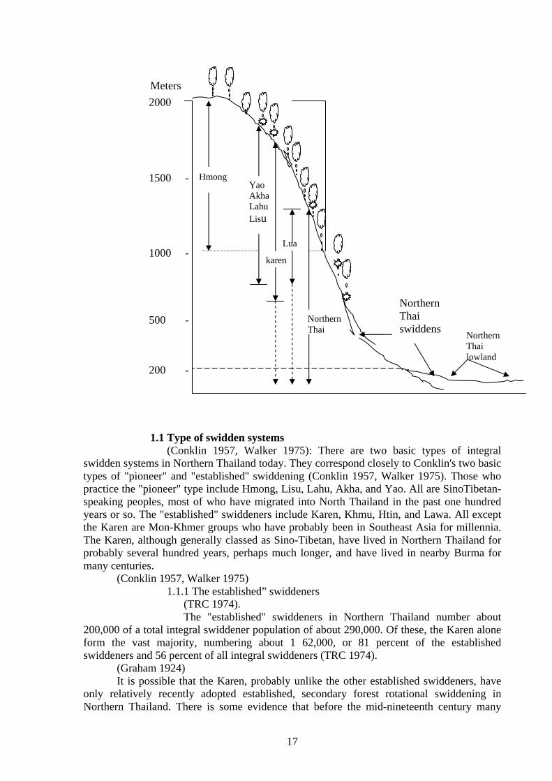
Meters
1.1 Type of swidden systems
(Conklin 1957, Walker 1975): There are two basic types of integral swidden systems in Northern Thailand today. They correspond closely to Conklin's two basic types of "pioneer" and "established'' swiddening (Conklin 1957, Walker 1975). Those who practice the "pioneer" type include Hmong, Lisu, Lahu, Akha, and Yao. All are SinoTibetan-speaking peoples, most of who have migrated into North Thailand in the past one hundred years or so. The "established" swiddeners include Karen, Khmu, Htin, and Lawa. All except the Karen are Mon-Khmer groups who have probably been in Southeast Asia for millennia. The Karen, although generally classed as Sino-Tibetan, have lived in Northern Thailand for probably several hundred years, perhaps much longer, and have lived in nearby Burma for many centuries. (Conklin 1957, Walker 1975)
1.1.1 The established” swiddeners (TRC 1974).
The "established" swiddeners in Northern Thailand number about 200,000 of a total integral swiddener population of about 290,000. Of these, the Karen alone form the vast majority, numbering about 1 62,000, or 81 percent of the established swiddeners and 56 percent of all integral swiddeners (TRC 1974).
(Graham 1924) It is possible that the Karen, probably unlike the other established swiddeners, have
only relatively recently adopted established, secondary forest rotational swiddening in Northern Thailand. There is some evidence that before the mid-nineteenth century many
1000 -
1500 -
500 -
200 -
Hmong Yao Akha Lahu Lisu
karen
Lua
Northern Thai Northern
Thai lowland
Northern Thai swiddens
2000
18
Karen were still rather mobile and preferred to farm virgin or highly regenerated forest. If this is true, there must have been a gradual shift in the direction of established swiddening.
(lijima 1970). Today, established swiddening is well institutionalized in virtually all Karen swidden
villages, although one researcher suspects that there are still several nomadic Karen villages left "in the deep forests of the western borderland of Mae Sarieng district"
1.1.2 The pioneer “swiddeners”
(Grandstaff 1979; Dessaint 1972; Bradley 1975; cf. Geddes 1976). The''pioneer" swiddeners of Northern Thailand account for about 44
per cent of the integral swiddener population. Most have arrived in Northern Thailand within the present century. Around the turn of the century, and perhaps as early as the mid-nineteenth century, isolated villages already existed in border areas, but it is probable that the great increase in pioneer swiddener population since that time has occurred more as a result of immigration from China, Burma, and Laos than from natural population growth. It is probable that these groups adopted the growing of opium as a significant cash crop around the third quarter of the nineteenth century, and that opium then facilitated more rapid expansion
(Grandstaff 1979; Dessaint 1972; Bradley 1975; cf. Geddes 1976). The Hmong (Meg, Miao) have been generally the most successful of the pioneer, primary forest swiddeners in pursuing the primary forest adaptation. There are very few suitable areas that they have not farmed at one time or another. In both Thailand and Laos they are by far the largest pioneer group. 2. Type of shifting cultivation in Thailand (Peter Kurt Hansen August 2001) Traditional shifting cultivation system in northern Thailand have commonly been divided into two principle types of shifting cultivation traditional used in northern Thailand. Table: 1 Terms applied to the two main types of shifting cultivation traditionally use in Northern Thailand. Type A Type B Source
The Karen people are perhaps one of the better-know indigenous groups in the Southeast Asian region particularly in Burma and Thailand. Recent unofficial estimates put the Karen population in Southeast Asia at around 3,000,000, of whom 402,095, live in Thailand.
Short cultivation – long fallow Secondary forest swiddening Established swiddening Cyclical swiddening Cyclical swiddening Non-poppy growing Mid-elevation shifting cultivation
Long cultivation – very long fallow Primary forest swiddening Pioneer swiddening Pioneer swiddening Non-cyclical swiddening Poppy growing High-elevation shifting cultivation
Kunstadter and Chapman 1978 Granstsff 1976 p.87f Walker 1992 p.10-14 Sutthi 1989 p. 108-9 Keen 1986 p.296-9 TRI 1986 p.33 Hansen 1995
19
The Karen people’s life today revolves around the practices of gathering and hunting, rotational slash and burning agriculture, rice terracing, livestock raising, improve kitchen gardening and horticultural gardening.
Rotational farming activities (IFAD, IDRC, CIIFAD, ICRF, and IIRR. 2001. Shifting Cultivation:)
1 New cropping season - Communities gather to join in the celebration and mutually assist
in preparing the new cultivation cycle. - Preferred month for weddings. - Plants harvested
2 Land preparation - Time designated to slash the undergrowth in the fields. - Branches of tree in the fields are lopped to a high level. - The stumps are left in the field allow them to regenerate. - Plants harvested - The “burning period” - The community members come together to build fire-breaks
around the settlement and cultivation area. - The building of fire-breaks involves the strict observance of taboos
to ensure that fire-breaks are of the beat quality in safe-guarding the community. This method of burning controls the spread of fire
- The women prepare seed for planting early in the morning. Planting starts after the burning period.
- A fence is built around the field for protection. - A small hut is built at the center of the field for storage purposes. - Plants harvested
3 Planting - Time for planting rice. - The entire community assist in one field at a time while the owner
of the field prepares meals for them - Time for celebration and courting for the young people. - Plants harvested include: small cabbage and bamboo shoots
4 Weeding - Time for weeding done mainly by the women (continued until
before harvesting). - Plants harvested include: pumpkin, taro, tomato, chili, eggplant,
cucumber 5 Pre-harvest ceremony
- Preparations for harvest are done ~ Religious strings are tied on the wrists.
~Hands of children are wash with chicken blood. There are the first to start the harvest.
- The community partakes of seasoned sticky rice. - Plants harvested 6 Harvesting
- Harvest time - Young people blow horns to call the people in the community to
harvest.
20
- Harvesting is done by couples (man cut the rice while the women tie it in bundles).
- Plants harvested include big cucumbers. 7 Threshing and drying
- Time for threshing. - Season seeds are collected from the fields. - Planted harvested include: sesame seeds, diff. Kinds of beans,
cucumber, pumpkin 8 End of cropping season
- Time for threshing. - Community members harvest rice and make rice whisky. - Rice whisky is shared with neighbors as evidence that the year’s
harvest is completed. - Funeral ceremony is done for the people who died during the
working season. - Plants harvested
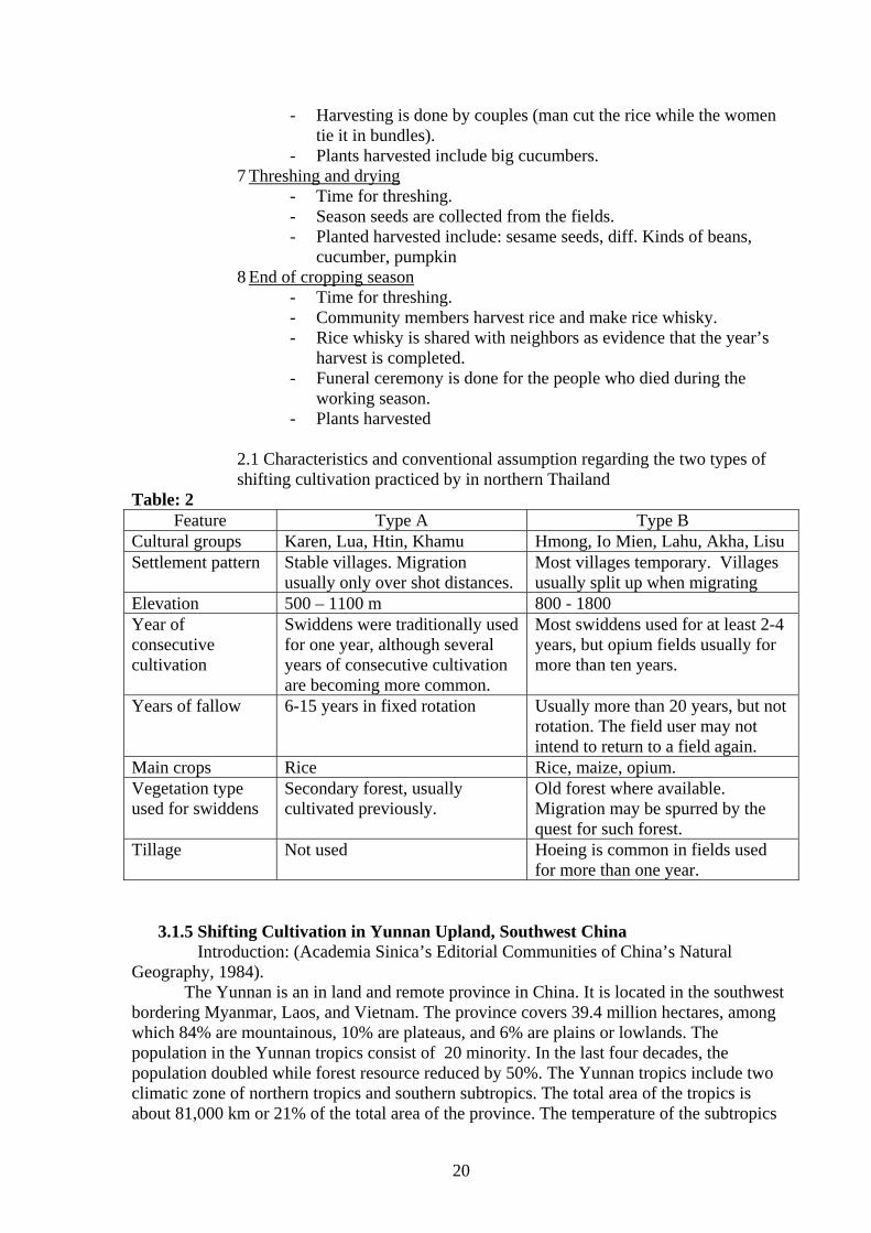
2.1 Characteristics and conventional assumption regarding the two types of
shifting cultivation practiced by in northern Thailand Table: 2
Feature Type A Type B Cultural groups Karen, Lua, Htin, Khamu Hmong, Io Mien, Lahu, Akha, Lisu Settlement pattern Stable villages. Migration
usually only over shot distances. Most villages temporary. Villages usually split up when migrating
Elevation 500 – 1100 m 800 - 1800 Year of consecutive cultivation
Swiddens were traditionally used for one year, although several years of consecutive cultivation are becoming more common.
Most swiddens used for at least 2-4 years, but opium fields usually for more than ten years.
Years of fallow 6-15 years in fixed rotation Usually more than 20 years, but not rotation. The field user may not intend to return to a field again.
Main crops Rice Rice, maize, opium. Vegetation type used for swiddens
Secondary forest, usually cultivated previously.
Old forest where available. Migration may be spurred by the quest for such forest.
Tillage Not used Hoeing is common in fields used for more than one year.
3.1.5 Shifting Cultivation in Yunnan Upland, Southwest China
Introduction: (Academia Sinica’s Editorial Communities of China’s Natural Geography, 1984).
The Yunnan is an in land and remote province in China. It is located in the southwest bordering Myanmar, Laos, and Vietnam. The province covers 39.4 million hectares, among which 84% are mountainous, 10% are plateaus, and 6% are plains or lowlands. The population in the Yunnan tropics consist of 20 minority. In the last four decades, the population doubled while forest resource reduced by 50%. The Yunnan tropics include two climatic zone of northern tropics and southern subtropics. The total area of the tropics is about 81,000 km or 21% of the total area of the province. The temperature of the subtropics
21
is (10’c) mean temperature of January 13-15’c. While those of the southern subtropics are 285 – 356 day.
1. The traditional of shifting cultivation in Yunnan upland, Southwest China
Problem encountered in shifting cultivation - Divers production systems due to the different ethnic groups in the region. - Shorter fallow period due to population increase and movement. - Degradation and depletion of natural resources due to over exploitation. - Environmental degradation because of large-scale use of chemical pesticides and fertilizer.
1 Type of shifting cultivation in region There are three types of shifting cultivation
1) No rotation 2) Short rotation 3) Long rotation
A. No rotation The land is cultivated only one during a period of seven to ten years. Some advantages of the more rotation system are:
1) It inhibits the growth of weeds, thus, enabling the crop to grow well;
2) Destructive insects are lessened; 3) Soil erosion is minimized because the plant grow at once; 4) A high yield in expected.
B. Sort rotation The land is cultivated continuously for two year and fallowed for a period of seven to ten years. C. Long rotation The land is cultivated continuously three to five years and then left uncultivated for the next 10-20 years.
1.2 Sustainable swidden agro ecosystem The diverse geographic and ethnography characteristics of yunnan province has led to the predominance of swidden system. However, the most common system in southwest Yunnan are:
1) The rattan and bamboo-based swidden 2) The jinuo sustainable swidden 2.1 Swidden cycle
The fallow period for swidden fields is maintained more than 13 years in jinuo communities and the vegetation cover of the land was observed to be better. For traditional swidden cultivation, community divided their forest into more than 13 zones by quality. The swidden cultivation rotates their use of land so that each zone has a minimum 13-year fallow period. During the fallow stage, buffalos are allowed to enter the fallow field to fertilize the soil with the manure. After the fallow period, the swidden land would already be covered with forest growth. The regenerated vegetation increase fertility of soil.
+ Activity of farming in Yunnan (Chen Sangyang, Pei Shengji and Xu Jianchu, 1993.)
1 Land preparation
22
- Slopes along stream in the swidden field, boundary edges of swidden cultivation field, patched with bigger tree or tree stumps in the swidden field are considered suitable locations for planting rattans. - After land allocation, the areas are cleared of vegetation for upland rice growing.
2 Planting - Seeds are collect from rattan forest or swidden fields while seeding are prepared in the some swidden field.
- Seeding are transplanted under shade tree or around - Vegetative propagation is also used develop rattan forest.
3 Maintenance - The rattan seedlings planted in the field are carefully protected from operations of cutting trees and burning the field.
4 Harvesting - Harvesting start from six to ten years after planting, or when rattan’s stem reaches 6 – 7 m in length. - Harvesting is done once every three or five years for small and lage-diameter rattan.
3.1.6 Shifting Cultivation Practices of the Hanunoo Mangyans, Mindoro Island, Philippines. Introduction: (A report on amn Integral System of shifting cultivation in the Philippines. 1994a). The indigenous people of Minoro Island, in central Philippines, are collectivelyknow as the Mangyans. The term Mangyan, however, covers various ethno linguistic groups scattered throughout the Island, namely the Alangan, Bangon, Gobanon, Batangan, Buhid, Iraya, Tadyawa, and Hanunoo. The Hanunoo Mangyans are found in the southern most tip of Minoro, most specifically in the municipality of Mansalay and Bulalacao, in the Province of Minoro Oriental. They are one of the least acculturated groups among the people of Minoro.
3.1.6.1 The Traditional of shifting cultivation of the Hanunoo Mangyans, Mindoro Island, Philippines
Prepared by Nestor T and Castor 1994 They practice shifting cultivation that is based on time-tested in digenous knowledge. This type of cultivation characterized by sustainable practices such as a) selectivity clearing and burning; b) adoption of soil erosion prevention techniques; c)promotion of crop diversity; d) maximization of the limited land; e) use of organic pesticides; and f) observance of along fallow period.
1 selectivity clearing and burning of forest (Castor, Nestor. 1994a. and Katutubo)
1) Clearing - General, clearing of primary forest is strictly prohibited by the community. Thus, shifting cultivation is practices only in the secondary forests. - Only the vegetation along the foothills is cleared for field preparation. - Areas that are exposed to strong winds and typhoons are considered unsuitable for cultivation.
23
- There are many taboos prohibiting the clearing of areas believed to be inhabited by spirits. Most of trees, mountains, rocks, and rivers are left undisturbed to appease the spirits. - Not all of the trees are cut. The leaves and twigs of woody species are merely pruned. It prevents the crops planted underneath from shading. The cutting of twigs and branches of trees are done carefully, starting from the uppermost branches down to the trunk. This method, called yinangaw, is done to ovoid accident and to protect plant and trees in the vicinity. - Many small trees are left untouched to serve as hulungan for
vines. 2) Burning
- Prior to actual burning, a wide strip of land around the intended farm is cleared of all vegetation. The perimeter area acts as a firebreak. This method prevents fire from spreading to adjacent areas. - To preserve trees with in the intended from, the Hanunoo Mangyans cover the trees trunks with several layers of banana stalks. This prevents the tree from smoldering during the burning stage.
2. Prevention of soil erosion To prevent soil erosion, the following measures are implemented:
- Trees and plants found in the steep portions of the mountains are left intact. - Generally, sloping land is not plowed. Digging sticks are used to plant seeds. - Rice bean is planted as cover crop along the contours of the farm.
3. Promotion of crop diversity The Hanunoo Mangyan value crop diversity. They purposely cultivate
and propagate various species and various of crops: - At least 104 various of upland paray (rice) are recognized and cultivated by the Hanunoo Mangyans. - Lumabung or mung beans (vigna sinensis L.) are intercropped with rice to replenish the nitrogen content of the soil. - Cereals, leafy vegetables, legumes, spices, dyes, fruit trees, and other the crops are cultivated within the same farm.
4. Maximized utilization of the land Through mixed cultivated, the limited land is put to maximum
use. As coffee trees are non-photosensitive, it is common to fine these trees under the shade of banana trees. Mais (maize), however, is not grown together with rice as its ears may fall on the rice stalks during strong winds.
5. Use of organic pesticides - Intercropping acts as organic check to pests. - Some insects ward off other pests that feed on nearby plants. - Batad (Andropogon sorghum) is grown beside the rice fields so that is grains would attract sparrows, thereby, leaving the rice grains free from birds.
6. Long fallow period Hanunoo Mangyan farming is characterized by short cultivation and
long fallow periods.
24
- The Tanman is utilized for approximately three to five years. After that, the land is abandoned to allow the soil to replenish its nutrients. - After another three-to-five-years period, the land is again abandoned in favor of a new location. He only returns to the original farm site if the said land has fully regained its productivity.
(Castor, Nestor. 1994a. and Katutubo).
3.2 Practices of Shifting Cultivation in the Lao PDR Introduction (Vienvonsith, Phantrnousy and Keo boulapha, Lao PDR): Lao PDR has more than 60 ethnic groups. Based on ethnicity, linguistics, and geographical characteristics, the ethnic group divide into three broad categories: Lao Loum (Lao of the lowland), Lao Theung (Lao of the mountain slopes), and Lao sung (Lao of the mountain summits). This classification is widely used by government and non-government agencies and individuals at international, national and regional levels when describing the Lao ethnic group. It also strongly reinforces the bia that the farmers of the “slope” and the “mountain summit” dwellers are responsible for the this destruction of the forest.
3.2.1 Shifting Cultivation Condition 3.2.1.1 Shifting cultivation in Lao
(Suvanthong 1995). Shifting cultivation is the dominant cropping systems in the uplands and
mountain of Lao PDR. As many as 300000 families are fully or partially engaged in shifting cultivation, equal to about 1.8 million people or 40% of the population. Assuming that each family plants about 1.5 hectares per year, the shifting cultivation area used annually would be around 450000 hectares. The total area in the shifting cultivation cycle is difficult to assess, but may be 2-2.5 million hectares, equal about 10% of the area of Laos.
The Northern region includes seven provinces which account for 41% of the area and 33% of the population in Lao PDR. It is a predominantly mountains region with only small area of flood plains and paddy farming are therefore secondary and about 65% of the shifting cultivation in Laos live in Northern (Suvanthong 1995).
Today, shifting cultivation in Laos is largely based on the cycle use of young secondary vegetation, although limited encroachment in older forest still takes place in isolated areas. However, over the years, shifting cultivation has considerably reduced the forest area to the detriment of timber resources and natural habitats. Where shifting cultivation is intense, accelerated erosion and changes in the water discharge may impair water resources for irrigation, hydropower and domestic use.
3.2.1.2 Extend of shifting cultivation (Bouahong, DoF), (Boualy and Bounthay, NFES, SCSEC) March 2003 Currently, people of the ethnic group and minorities mentioned above, especially those living in the remote highland areas, still practice mainly shifting cultivation particularly in the North and in the mountain along the eastern border (Lao-Viet man) from the middle to the southern parts of the country. the actual situation of shifting cultivation for upland rice vary from area to area and from year to year. Therefore, we could not collect accurate data but indicative ones are as follows; Shifting cultivation data in 1990 indicated that 210,204 households practiced shifting cultivation in 245,877 ha In 1992, 166,723 households practiced shifting cultivation in 212,068 ha In 2000, 174,036 households practiced shifting cultivation in 118,900 ha In 2001, 99,369 households practiced shifting cultivation in 109,890 ha
3.2.1.3 Causes and Necessities for Practicing Shifting Cultivation
25
Problem 1: the people of the ethnic minorities are traditional familiar with shifting cultivation and previously, there was no policy or direction for establishing permanent occupation for them.
Problem 2: Regarding environmental condition most land areas are mountainous. Land areas for permanent cropping and livestock production are limited such as the paddy fields and pasture land. Water is not available for cultivating rice in the dry season. People are settled in scattered groups, and many areas during the war is the cases that they lack arable land and are forced to open new land for Agricultural production. In some areas, it is necessary to cut forest for shifting cultivation.
Problem 3: Generally, crop and livestock production in area with shifting cultivation are still practiced without application of technology on site preparation, application of fertilizers, high yield varieties, water supply, application of pesticides and vaccination. Consequently, yield decrease year by year, while consumption demand of the country is increasing. Therefore, it is necessary for them to continue practicing shifting cultivation and expanding the shifting cultivation fields. 3.2.1.4 The Traditional of shifting cultivation in Lao PDR
3.2.1.4.1 Forms of shifting cultivation in Lao PDR by (Bouahong, DoF), (Boualy and Bounthay, NFES, SCSEC) March 2003 Generally speaking, there are two forms of shifting cultivation in Lao PDR
1. Rotation upland cultivation During the last 80 years, population was not rapidly increasing.
Shifting cultivation with upland rice had a follow period of 15-20 years, and in each site crops were produced only in the first 2-3 years after cleaning the fields. In this form of shifting cultivation, villagers mutually exchange their labor in slashing and burning, and clearing large field that include hills next to each other near the village of certain ethnic minority. The reason for a 15-20 year long fallow period was that land area and rich forests were abundant, and to give opportunity to trees previously cut to rehabilitate and to restore soil fertility. As the result of the rapid population growth plus the implementation of policies on land and forest allocation and arrangement of permanent settlement, and policy on people’s poverty alleviation, the shifting cultivation systems has shorter follow period and is more limited. Follow is only lasting 4-6 years due to population growth in each area, determination and allocation of land and for crop and livestock production and forest allocation for management and utilization based on joint agreements. Area for rotation cultivation with upland rice are more limited than before. for example, farmers households receive one to three pieces of land, and practice shifting cultivation with upland rice and other crop in a rotation of approximately 3 or 4 years and than return to the old fields. It is seen that this systems has short rotation.
2. Pioneering upland cultivation Pioneering upland cultivation is clearance of forest mainly for growing
rice and some commercial crops. The cultivators repast these activities in the same field during the first 2-3 years. As yield decrease, soil gets infertile, and grasses increasingly hamper crops, they abandon the field and slash forest in other area. When the old field abandoned for along time become young follow, but in many case more Imperator cylindrical grows up, lands are covered more by bamboo, and only after several decades, they may be natural forests. This pioneering upland cultivation presents a significant threat o the forests that hamper the regeneration of forest, and forests take relatively long time to rehabilitate.
3.2.1.4.2 Forms of shifting cultivation in Lao PDR by (Draft Final Report
Volume 1 speaking MAF Lao PDR)
26
Shifting cultivation is a traditional upland cropping systems whereby a piece of primary or secondary forest, bamboo or bush is cleared and farmed until the soil fertility is depleted, reducing labor productivity below a worthwhile level. The land is then left to fully or partially regain its fertility through regeneration of the original and/or new cover species. After this resting period, ranging for about 5 to 20 years, the cycle is repeated. There are three types of shifting cultivation.
1. A traditional swidden rotational system In this systems, the cycle ranges from about fifteen to twenty years.
The cleared upland sloping area is farmed for two to three years, either under rice or rice and maize etc. with the last crop sometime being cassava. This system is sustainable at low population densities with sufficient time in bush fallow to ameliorate soil fertility depleted in the cropping phase. As population densities increases, the rotation shortens to the point where the system may not be sustainable.
2. A pioneering exploitive system This pioneering form of shifting cultivation is practiced in former
opium poppy production areas. In these areas the cleared land is continuously cropped until severely degraded after which it is abandoned. The cultivator then move to a completely new forest area to continue the cropping cycle. Impetrate and other aggressive weeds and grasses invade abandoned areas. The land generally remains under these species without the usual succession to bamboo, bush and then trees.
3. A transitional shortening rotation system This is a transition system to sedentary Agriculture. In many areas
because of the land allocation, tax and the delineation of forest boundaries with village agreements, the shifting cultivation cycle has been truncated to between four and six years. Thus, the land is cleared after only a three to five year’s rest and then put under rice and maize etc. for one to two years. Productivity is declining in these areas through soil degradation and erosion. Unless steps are taken, productivity will continue to decline presenting serious livelihood problems for the communities in these areas.
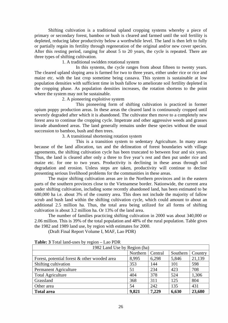
The major shifting cultivation areas are in the Northern provinces and in the eastern parts of the southern provinces close to the Vietnamese border. Nationwide, the current area under shifting cultivation, including some recently abandoned land, has been estimated to be 680,000 ha i.e. about 3% of the country area. This does not include the majority of fallow scrub and bush land within the shifting cultivation cycle, which could amount to about an additional 2.5 million ha. Thus, the total area being utilized for all forms of shifting cultivation is about 3.2 million ha. Or 13% of the land area.
The number of families practicing shifting cultivation in 2000 was about 340,000 or 2.06 million. This is 39% of the total population and 48% of the rural population. Table gives the 1982 and 1989 land use, by region with estimates for 2000.
(Draft Final Report Volume I, MAF, Lao PDR)
Table: 3 Total land-uses by region – Lao PDR 1982 Land Use by Region (ha)
Northern Central Southern CountryForest, potential forest & other wooded area 8,995 6,298 5,846 21,139 Shifting cultivation 353 144 101 598 Permanent Agriculture 51 234 423 708 Total Agriculture 404 378 524 1,306 Grassland 368 311 125 804 Other area 54 242 135 431 Total area 9,821 7,229 6,630 23,680
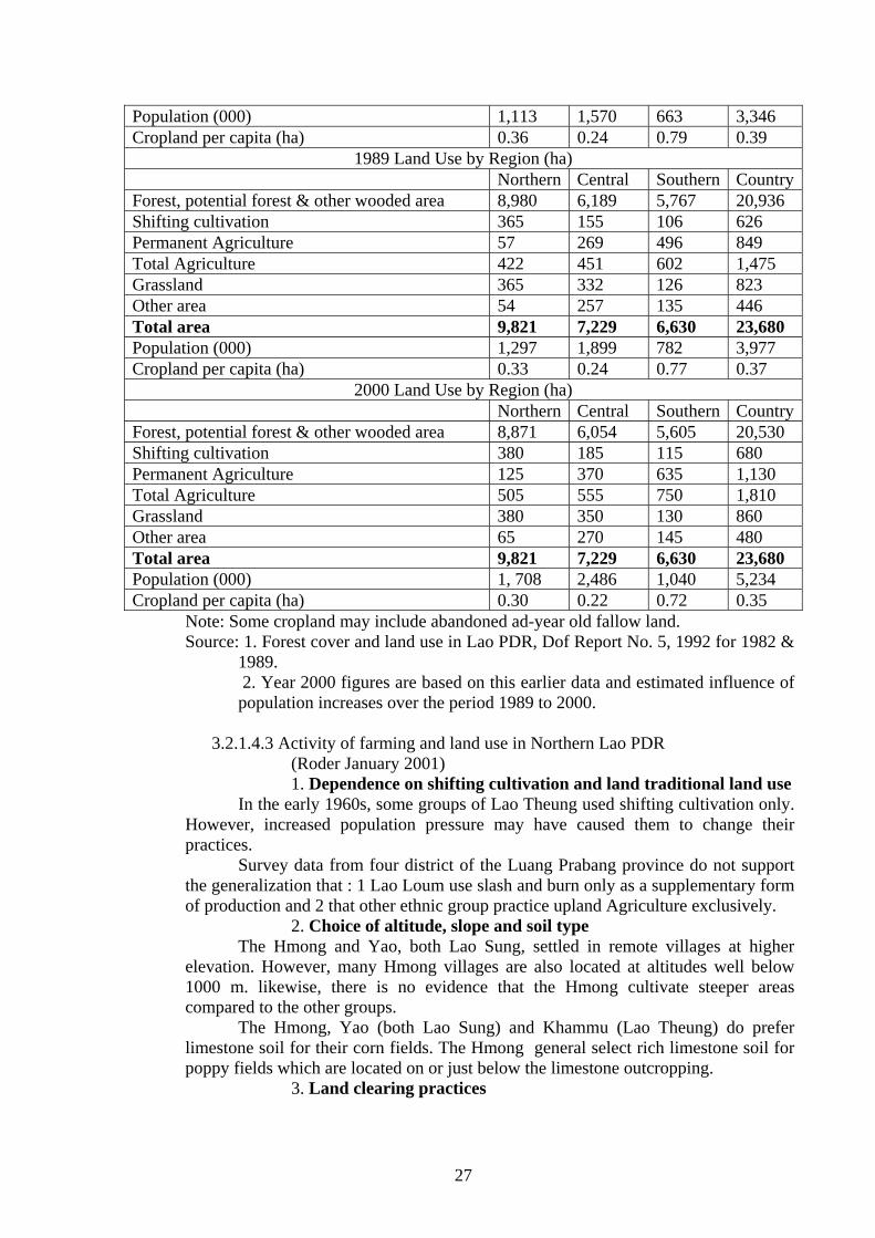
27
Population (000) 1,113 1,570 663 3,346 Cropland per capita (ha) 0.36 0.24 0.79 0.39
1989 Land Use by Region (ha) Northern Central Southern CountryForest, potential forest & other wooded area 8,980 6,189 5,767 20,936 Shifting cultivation 365 155 106 626 Permanent Agriculture 57 269 496 849 Total Agriculture 422 451 602 1,475 Grassland 365 332 126 823 Other area 54 257 135 446 Total area 9,821 7,229 6,630 23,680 Population (000) 1,297 1,899 782 3,977 Cropland per capita (ha) 0.33 0.24 0.77 0.37
2000 Land Use by Region (ha) Northern Central Southern CountryForest, potential forest & other wooded area 8,871 6,054 5,605 20,530 Shifting cultivation 380 185 115 680 Permanent Agriculture 125 370 635 1,130 Total Agriculture 505 555 750 1,810 Grassland 380 350 130 860 Other area 65 270 145 480 Total area 9,821 7,229 6,630 23,680 Population (000) 1, 708 2,486 1,040 5,234 Cropland per capita (ha) 0.30 0.22 0.72 0.35 Note: Some cropland may include abandoned ad-year old fallow land.
Source: 1. Forest cover and land use in Lao PDR, Dof Report No. 5, 1992 for 1982 & 1989.
2. Year 2000 figures are based on this earlier data and estimated influence of population increases over the period 1989 to 2000.
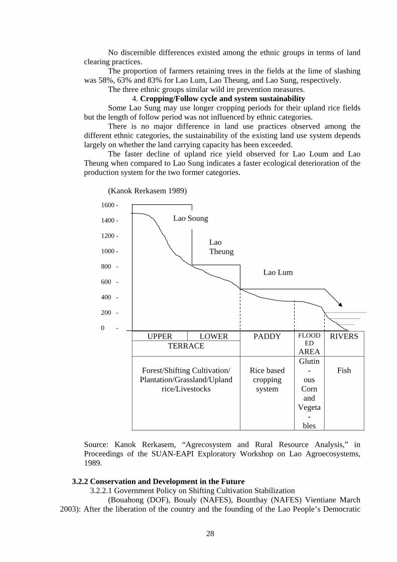
3.2.1.4.3 Activity of farming and land use in Northern Lao PDR
(Roder January 2001) 1. Dependence on shifting cultivation and land traditional land use In the early 1960s, some groups of Lao Theung used shifting cultivation only. However, increased population pressure may have caused them to change their practices. Survey data from four district of the Luang Prabang province do not support the generalization that : 1 Lao Loum use slash and burn only as a supplementary form of production and 2 that other ethnic group practice upland Agriculture exclusively. 2. Choice of altitude, slope and soil type The Hmong and Yao, both Lao Sung, settled in remote villages at higher elevation. However, many Hmong villages are also located at altitudes well below 1000 m. likewise, there is no evidence that the Hmong cultivate steeper areas compared to the other groups. The Hmong, Yao (both Lao Sung) and Khammu (Lao Theung) do prefer limestone soil for their corn fields. The Hmong general select rich limestone soil for poppy fields which are located on or just below the limestone outcropping. 3. Land clearing practices
28
No discernible differences existed among the ethnic groups in terms of land clearing practices. The proportion of farmers retaining trees in the fields at the lime of slashing was 58%, 63% and 83% for Lao Lum, Lao Theung, and Lao Sung, respectively. The three ethnic groups similar wild ire prevention measures. 4. Cropping/Follow cycle and system sustainability Some Lao Sung may use longer cropping periods for their upland rice fields but the length of follow period was not influenced by ethnic categories. There is no major difference in land use practices observed among the different ethnic categories, the sustainability of the existing land use system depends largely on whether the land carrying capacity has been exceeded. The faster decline of upland rice yield observed for Lao Loum and Lao Theung when compared to Lao Sung indicates a faster ecological deterioration of the production system for the two former categories. (Kanok Rerkasem 1989)
UPPER LOWER PADDY FLOOD
ED AREA
RIVERS TERRACE
Forest/Shifting Cultivation/
Plantation/Grassland/Upland rice/Livestocks
Rice based cropping system
Glutin-
ous Corn and
Vegeta-
bles
Fish
Source: Kanok Rerkasem, “Agrecosystem and Rural Resource Analysis,” in Proceedings of the SUAN-EAPI Exploratory Workshop on Lao Agroecosystems, 1989.
3.2.2 Conservation and Development in the Future 3.2.2.1 Government Policy on Shifting Cultivation Stabilization
(Bouahong (DOF), Boualy (NAFES), Bounthay (NAFES) Vientiane March 2003): After the liberation of the country and the founding of the Lao People’s Democratic
Lao Soung
Lao Theung
Lao Lum
1600 - 1400 - 1200 - 1000 - 800 - 600 - 400 - 200 - 0 -
29
Republic, the Party Government formulated policies on forestry development, as follows: Management, protection and utilization of forest resources in sustainable manner. First National Forest Congress was help in May 1989. It clearly showed the importance of forest s and determined the strategic direction, policy and several measures for protection, rehabilitation, afforestation and utilization of forest resources to increase their richness including protection of aquatic animal and wildlife, to find approaches for stabilization of shifting cultivation, and development of forests in close connection with poverty alleviation and increase promotion of commercial production of farmers associated with the establishment of permanent occupation and settlement for people in highland areas, especially shifting cultivators. Shifting cultivation stabilization and establishment of permanent occupation program is consequently important government priority program. Sine the IV to VII Party Congresses, the shifting cultivation stabilization program has been always considered as the important issue to find approaches and measures for alleviating poverty of shifting cultivation y 2010 and alleviating poverty throughout the country by 2020. To realize these targets 61 focal areas for rural development have been determined throughout the country. There are 5 focal provinces for stabilizing shifting cultivation in the Northern ( Luang prabang, Oudomxay, Huaphanh, Phongsaly and Luang Namtha), 46 focal districts in all part of the country are target districts for alleviating poverty.
3.2.2.2 Establishment of Permanent Occupation
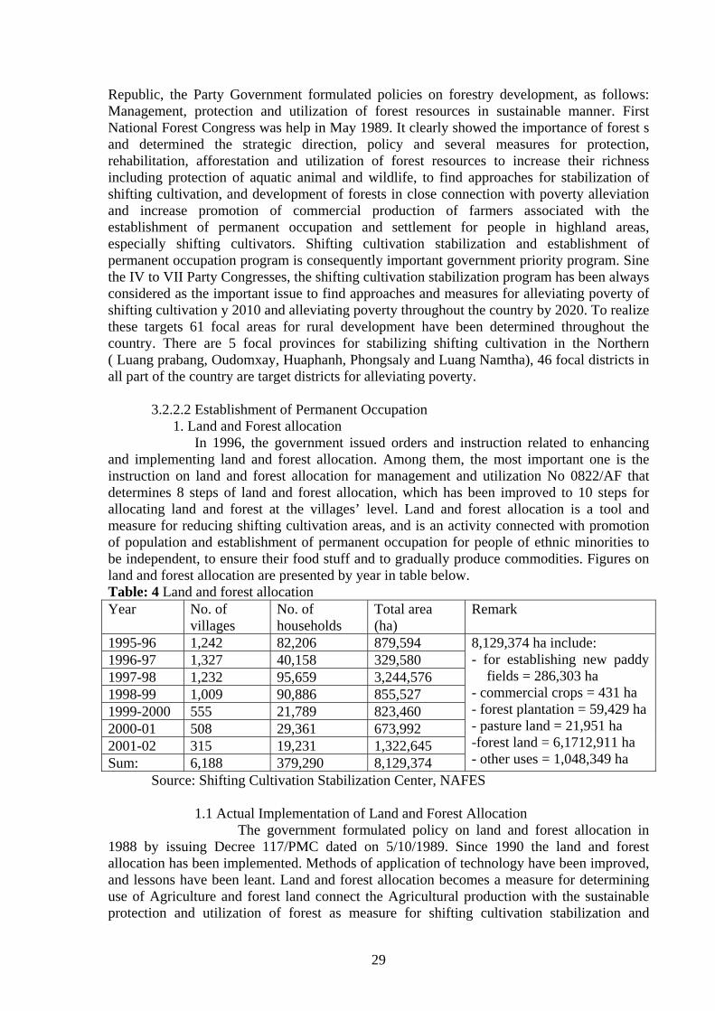
1. Land and Forest allocation In 1996, the government issued orders and instruction related to enhancing and implementing land and forest allocation. Among them, the most important one is the instruction on land and forest allocation for management and utilization No 0822/AF that determines 8 steps of land and forest allocation, which has been improved to 10 steps for allocating land and forest at the villages’ level. Land and forest allocation is a tool and measure for reducing shifting cultivation areas, and is an activity connected with promotion of population and establishment of permanent occupation for people of ethnic minorities to be independent, to ensure their food stuff and to gradually produce commodities. Figures on land and forest allocation are presented by year in table below. Table: 4 Land and forest allocation Year No. of
villages No. of households
Total area (ha)
Remark
1995-96 1,242 82,206 879,594 8,129,374 ha include: - for establishing new paddy
fields = 286,303 ha - commercial crops = 431 ha - forest plantation = 59,429 ha - pasture land = 21,951 ha -forest land = 6,1712,911 ha - other uses = 1,048,349 ha
1996-97 1,327 40,158 329,580 1997-98 1,232 95,659 3,244,576 1998-99 1,009 90,886 855,527 1999-2000 555 21,789 823,460 2000-01 508 29,361 673,992 2001-02 315 19,231 1,322,645 Sum: 6,188 379,290 8,129,374 Source: Shifting Cultivation Stabilization Center, NAFES
1.1 Actual Implementation of Land and Forest Allocation The government formulated policy on land and forest allocation in 1988 by issuing Decree 117/PMC dated on 5/10/1989. Since 1990 the land and forest allocation has been implemented. Methods of application of technology have been improved, and lessons have been leant. Land and forest allocation becomes a measure for determining use of Agriculture and forest land connect the Agricultural production with the sustainable protection and utilization of forest as measure for shifting cultivation stabilization and
30
establishment of permanent occupation. This is a very detailed ad relatively complicated work to carry out in accordance with real condition of each locality. Activity of Land and Forest allocation are carried out, as follows:
- Perpetrating for field activities, planting land use, and land and forest allocation. - Surveying and mapping village boundaries. Village Agriculture and forest land. - Collecting and analyzing data mainly on land ownership, land uses, land occupation, socioeconomic data, problems and needs of villages as well as condition for land and forest allocation. - Village land use planning including forestland use plan, various Agriculture land in accordance with real condition of the villages - Land and forest allocation is carried out based on data on each aspect collected through the consultation of the villages. - Measuring Agriculture land should concentrate on allocation of land to families with few areas for Agriculture and on allocation of forest to villages for sustainable management and uses. - Preparing agreement on Agriculture land and forestland, and transferring the temporary land use right to the villages. - Recording Agriculture lands allocation is the take that summarizes all temporary land use certificates of villagers and villages. - The last work is monitoring and evaluating the implementation of land and forest allocation.
1.2 Land Use Determination form Land and Forest Allocation To ensure that Agriculture and forest land allocated are used in accordance with the condition and effective land use criteria in each area, especially in highland area, land area are determined based on slopes, as follows:
- Land with slope from 0-12% can be used for paddy rice production if areas are sustainable land use areas. - Land with slope from 12-25 % can be used for production of paddy rice on terraces, livestock, fruit tree and commercial crops - Land with slope from 25-36 % can be used for production upland crops (rice, commercial crops), livestock, fruit tree and agro forestry for commercial purpose - Land with slope from 36-45% can be used for production of upland crops (rice, commercial crops), fruit tree and agro forestry for commercial purpose - Land with slope from 45 % is to be used as protection forestland for preventing soil erosion and protecting environment.
3.2.2.3 Alternatives of shifting cultivation stabilization and Establishment of Permanent Occupation and Some Models in Northern Focal Provinces
1. Alternatives of shifting cultivation stabilization and Establishment of Permanent Occupation
1) Increasing productivity of lowland rice production in rainy and dry season 2) Perennial crops or cropping integrated with livestock 3) Annual crops, vegetables and short-lived crops 4) Raising small animals, poultry and pigs including producing off-spring for
commercial purpose 5) Raising fishes and aquatic animals including producing off-spring for commercial
purpose 6) Raising large animals with own fund and credits from banks
31
7) Tree planting (Fast growing and commercial species) 8) Establishment tree nurseries for commercial purpose 9) Planting and collecting NTFP s in accordance with the capacity of the localities 10) Trades, service and processing 11) Handicraft 12) Other income generating occupation
2. Some models in the Northern focal province In 5 Northern focal provinces, Luang Prabang, Oudomxay, Huaphanh,
phongsaly, and Luang Namtha many households stopped shifting cultivation and engage in permanent occupation mentioned above. They generate an certain income and their standard of living is approved, as follows:
>Luang Prabang: There are many model households in KoK Ngie and Enh villages in
Xieng Ngeun district. They plant pineapples for commercial purpose and generate an annual income of 5-10 million Kip/Household.
>Oudomay: many households of tatmouane village stop practicing shifting cultivation
and collect and grow cardamom, peuak, eagle wood based on plans, generating an income of 2-2.5 million Kip/year/household.
>Luang Namtha: Many households of Buamphieng village in Namtha district become
model household for growing fruit trees, maize and sugar cane I integrated form. They generate an icome of 1.6-6.5 million Kip/year.
>Phongsaly: Villages of Phonxay Neua and Huai Mouane in Meuang Khua district
stop practicing shifting cultivation. They grow tamarind, Mak Khen and plant teak, and firstly earn an income of 5 million Kip/year.
>Huaphanh: Instead of practicing shifting cultivation villages of Phienghom village in
Xiengkho district grow fruit trees in accordance with condition such as longan and mazie, and produce seedling for commercial purpose. They generate an income up to 3.8 million Kip/year.
3.2.2.4 Analysis of Problems and Cause and Solutions
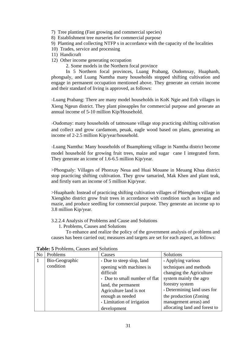
1. Problems, Causes and Solutions To enhance and realize the policy of the government analysis of problems and
causes has been carried out; measures and targets are set for each aspect, as follows: Table: 5 Problems, Causes and Solutions No Problems Causes Solutions 1 Bio-Geographic
condition • Due to steep slop, land opening with machines is difficult • Due to small number of flat land, the permanent Agriculture land is not enough as needed • Limitation of irrigation development
• Applying various techniques and methods changing the Agriculture system mainly the agro forestry system • Determining land uses for the production (Zoning management areas) and allocating land and forest to
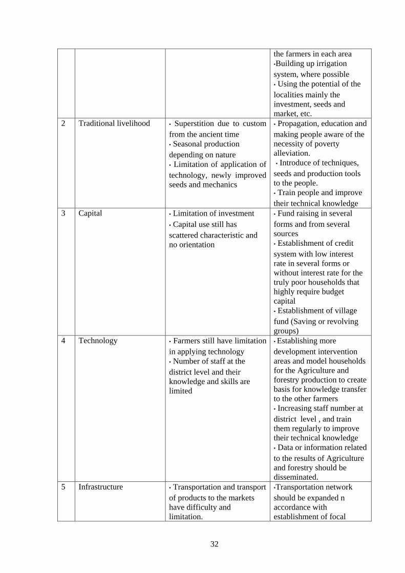
32
the farmers in each area •Building up irrigation system, where possible • Using the potential of the localities mainly the investment, seeds and market, etc.
2 Traditional livelihood • Superstition due to custom from the ancient time • Seasonal production depending on nature • Limitation of application of technology, newly improved seeds and mechanics
• Propagation, education and making people aware of the necessity of poverty alleviation. • Introduce of techniques, seeds and production tools to the people. • Train people and improve their technical knowledge
3 Capital • Limitation of investment • Capital use still has scattered characteristic and no orientation
• Fund raising in several forms and from several sources • Establishment of credit system with low interest rate in several forms or without interest rate for the truly poor households that highly require budget capital • Establishment of village fund (Saving or revolving groups)
4 Technology • Farmers still have limitation in applying technology • Number of staff at the district level and their knowledge and skills are limited
• Establishing more development intervention areas and model households for the Agriculture and forestry production to create basis for knowledge transfer to the other farmers • Increasing staff number at district level , and train them regularly to improve their technical knowledge • Data or information related to the results of Agriculture and forestry should be disseminated.
5 Infrastructure • Transportation and transport of products to the markets have difficulty and limitation.
•Transportation network should be expanded n accordance with establishment of focal
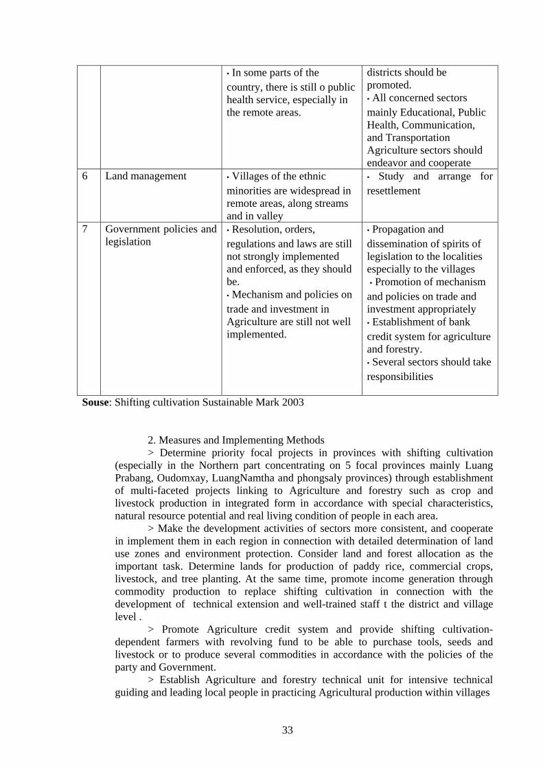
33
• In some parts of the country, there is still o public health service, especially in the remote areas.
districts should be promoted. • All concerned sectors mainly Educational, Public Health, Communication, and Transportation Agriculture sectors should endeavor and cooperate
6 Land management • Villages of the ethnic minorities are widespread in remote areas, along streams and in valley
• Study and arrange for resettlement
7 Government policies and legislation
• Resolution, orders, regulations and laws are still not strongly implemented and enforced, as they should be. • Mechanism and policies on trade and investment in Agriculture are still not well implemented.
• Propagation and dissemination of spirits of legislation to the localities especially to the villages • Promotion of mechanism and policies on trade and investment appropriately • Establishment of bank credit system for agriculture and forestry. • Several sectors should take responsibilities
Souse: Shifting cultivation Sustainable Mark 2003 2. Measures and Implementing Methods > Determine priority focal projects in provinces with shifting cultivation
(especially in the Northern part concentrating on 5 focal provinces mainly Luang Prabang, Oudomxay, LuangNamtha and phongsaly provinces) through establishment of multi-faceted projects linking to Agriculture and forestry such as crop and livestock production in integrated form in accordance with special characteristics, natural resource potential and real living condition of people in each area.
> Make the development activities of sectors more consistent, and cooperate in implement them in each region in connection with detailed determination of land use zones and environment protection. Consider land and forest allocation as the important task. Determine lands for production of paddy rice, commercial crops, livestock, and tree planting. At the same time, promote income generation through commodity production to replace shifting cultivation in connection with the development of technical extension and well-trained staff t the district and village level .
> Promote Agriculture credit system and provide shifting cultivation-dependent farmers with revolving fund to be able to purchase tools, seeds and livestock or to produce several commodities in accordance with the policies of the party and Government.
> Establish Agriculture and forestry technical unit for intensive technical guiding and leading local people in practicing Agricultural production within villages
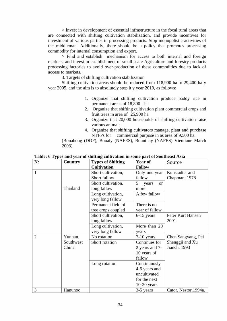
34
> Invest in development of essential infrastructure in the focal rural areas that are connected with shifting cultivation stabilization, and provide incentives for investment of various parties in processing products. Stop monopolistic activities of the middleman. Additionally, there should be a policy that promotes processing commodity for internal consumption and export.
> Find and establish mechanism for access to both internal and foreign markets, and invest in establishment of small scale Agriculture and forestry products processing factories to avoid over-production of these commodities due to lack of access to markets.
3. Targets of shifting cultivation stabilization Shifting cultivation areas should be reduced from 118,900 ha to 29,400 ha y
year 2005, and the aim is to absolutely stop it y year 2010, as follows:
1. Organize that shifting cultivation produce paddy rice in permanent areas of 18,800 ha
2. Organize that shifting cultivation plant commercial crops and fruit trees in area of 25,900 ha
3. Organize that 20,000 households of shifting cultivation raise various animals
4. Organize that shifting cultivators manage, plant and purchase NTFPs for commercial purpose in as area of 9,500 ha.
(Bouahong (DOF), Boualy (NAFES), Bounthay (NAFES) Vientiane March 2003)
Table: 6 Types and year of shifting cultivation in some part of Southeast Asia N: Country Types of Shifting
Cultivation Year of Fallow
Source
1 Thailand
Short cultivation, Short fallow
Only one year fallow
Kunstadter and Chapman, 1978
Short cultivation, long fallow
5 years or more
Long cultivation, very long fallow
A few fallow
Permanent field of tree crops coupled
There is no year of fallow
Short cultivation, long fallow
6-15 years Peter Kurt Hansen 2001
Long cultivation, very long fallow
More than 20 years
2 Yunnan, Southwest China
No rotation 7-10 years Chen Sangyang, Pei Shenggji and Xu Jianch, 1993
Short rotation Continues for 2 years and 7-10 years of fallow
Long rotation Continuously 4-5 years and uncultivated for the next 10-20 years
3 Hanunoo 3-5 years Cator, Nestor.1994a.
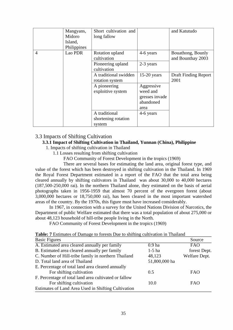
35
Mangyans, Midoro Island, Philippines
Short cultivation and long fallow
and Katutudo
4 Lao PDR Rotation upland cultivation
4-6 years Bouathong, Bounly and Bounthay 2003
Pioneering upland cultivation
2-3 years
A traditional swidden rotation system
15-20 years Draft Finding Report 2001
A pioneering exploitive system
Aggressive weed and gresses invade abandoned area
A traditional shortening rotation system
4-6 years
3.3 Impacts of Shifting Cultivation
3.3.1 Impact of Shifting Cultivation in Thailand, Yunnan (China), Philippine 1. Impacts of shifting cultivation in Thailand
1.1 Losses resulting from shifting cultivation FAO Community of Forest Development in the tropics (1969) There are several bases for estimating the land area, original forest type, and value of the forest which has been destroyed in shifting cultivation in the Thailand. In 1969 the Royal Forest Department estimated in a report of the FAO that the total area being cleared annually by shifting cultivators in Thailand was about 30,000 to 40,000 hectares (187,500-250,000 rai). In the northern Thailand alone, they estimated on the basis of aerial photographs taken in 1956-1959 that almost 70 percent of the evergreen forest (about 3,000,000 hectares or 18,750,000 rai), has been cleared in the most important watershed areas of the country. By the 1970s, this figure must have increased considerably. In 1967, in connection with a survey for the United Nations Division of Narcotics, the Department of public Welfare estimated that there was a total population of about 275,000 or about 48,123 household of hill-tribe people living in the North. FAO Community of Forest Development in the tropics (1969) Table: 7 Estimates of Damage to forests Due to shifting cultivation in Thailand Basic Figures Source A. Estimated area cleared annually per family 0.9 ha FAO B. Estimated area cleared annually per family 1-5 ha forest Dept. C. Number of Hill-tribe family in northern Thailand 48,123 Welfare Dept. D. Total land area of Thailand 51,800,000 ha E. Percentage of total land area cleared annually For shifting cultivation 0.5 FAO F. Percentage of total land area cultivated or fallow For shifting cultivation 10.0 FAO Estimates of Land Area Used in Shifting Cultivation
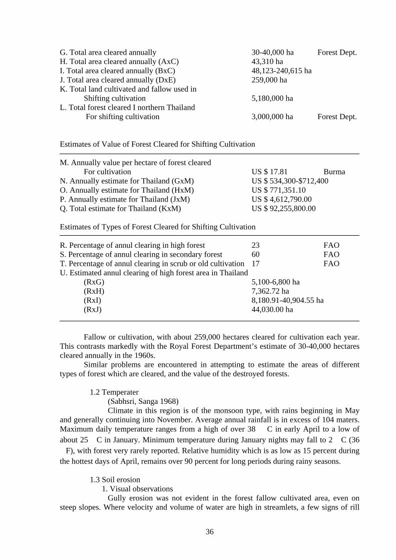
36
G. Total area cleared annually 30-40,000 ha Forest Dept. H. Total area cleared annually (AxC) 43,310 ha I. Total area cleared annually (BxC) 48,123-240,615 ha J. Total area cleared annually (DxE) 259,000 ha K. Total land cultivated and fallow used in Shifting cultivation 5,180,000 ha L. Total forest cleared I northern Thailand For shifting cultivation 3,000,000 ha Forest Dept. Estimates of Value of Forest Cleared for Shifting Cultivation M. Annually value per hectare of forest cleared For cultivation US $ 17.81 Burma N. Annually estimate for Thailand (GxM) US $ 534,300-$712,400 O. Annually estimate for Thailand (HxM) US $ 771,351.10 P. Annually estimate for Thailand (JxM) US $ 4,612,790.00 Q. Total estimate for Thailand (KxM) US $ 92,255,800.00 Estimates of Types of Forest Cleared for Shifting Cultivation R. Percentage of annul clearing in high forest 23 FAO S. Percentage of annul clearing in secondary forest 60 FAO T. Percentage of annul clearing in scrub or old cultivation 17 FAO U. Estimated annul clearing of high forest area in Thailand (RxG) 5,100-6,800 ha (RxH) 7,362.72 ha (RxI) 8,180.91-40,904.55 ha (RxJ) 44,030.00 ha Fallow or cultivation, with about 259,000 hectares cleared for cultivation each year. This contrasts markedly with the Royal Forest Department’s estimate of 30-40,000 hectares cleared annually in the 1960s. Similar problems are encountered in attempting to estimate the areas of different types of forest which are cleared, and the value of the destroyed forests. 1.2 Temperater (Sabhsri, Sanga 1968) Climate in this region is of the monsoon type, with rains beginning in May and generally continuing into November. Average annual rainfall is in excess of 104 maters. Maximum daily temperature ranges from a high of over 38 � C in early April to a low of about 25 �C in January. Minimum temperature during January nights may fall to 2 �C (36 �F), with forest very rarely reported. Relative humidity which is as low as 15 percent during the hottest days of April, remains over 90 percent for long periods during rainy seasons.
1.3 Soil erosion 1. Visual observations
Gully erosion was not evident in the forest fallow cultivated area, even on steep slopes. Where velocity and volume of water are high in streamlets, a few signs of rill
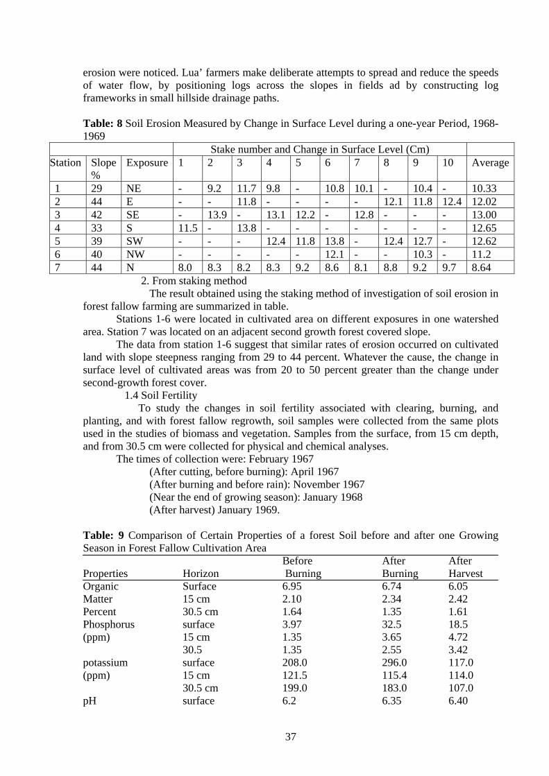
37
erosion were noticed. Lua’ farmers make deliberate attempts to spread and reduce the speeds of water flow, by positioning logs across the slopes in fields ad by constructing log frameworks in small hillside drainage paths. Table: 8 Soil Erosion Measured by Change in Surface Level during a one-year Period, 1968-1969
Stake number and Change in Surface Level (Cm) Station Slope
% Exposure 1 2 3 4 5 6 7 8 9 10 Average
1 29 NE - 9.2 11.7 9.8 - 10.8 10.1 - 10.4 - 10.33 2 44 E - - 11.8 - - - - 12.1 11.8 12.4 12.02 3 42 SE - 13.9 - 13.1 12.2 - 12.8 - - - 13.00 4 33 S 11.5 - 13.8 - - - - - - - 12.65 5 39 SW - - - 12.4 11.8 13.8 - 12.4 12.7 - 12.62 6 40 NW - - - - - 12.1 - - 10.3 - 11.2 7 44 N 8.0 8.3 8.2 8.3 9.2 8.6 8.1 8.8 9.2 9.7 8.64
2. From staking method The result obtained using the staking method of investigation of soil erosion in forest fallow farming are summarized in table. Stations 1-6 were located in cultivated area on different exposures in one watershed area. Station 7 was located on an adjacent second growth forest covered slope. The data from station 1-6 suggest that similar rates of erosion occurred on cultivated land with slope steepness ranging from 29 to 44 percent. Whatever the cause, the change in surface level of cultivated areas was from 20 to 50 percent greater than the change under second-growth forest cover.
1.4 Soil Fertility To study the changes in soil fertility associated with clearing, burning, and planting, and with forest fallow regrowth, soil samples were collected from the same plots used in the studies of biomass and vegetation. Samples from the surface, from 15 cm depth, and from 30.5 cm were collected for physical and chemical analyses. The times of collection were: February 1967 (After cutting, before burning): April 1967 (After burning and before rain): November 1967 (Near the end of growing season): January 1968 (After harvest) January 1969. Table: 9 Comparison of Certain Properties of a forest Soil before and after one Growing Season in Forest Fallow Cultivation Area Before After After Properties Horizon Burning Burning Harvest Organic Surface 6.95 6.74 6.05 Matter 15 cm 2.10 2.34 2.42 Percent 30.5 cm 1.64 1.35 1.61 Phosphorus surface 3.97 32.5 18.5 (ppm) 15 cm 1.35 3.65 4.72 30.5 1.35 2.55 3.42 potassium surface 208.0 296.0 117.0 (ppm) 15 cm 121.5 115.4 114.0 30.5 cm 199.0 183.0 107.0 pH surface 6.2 6.35 6.40
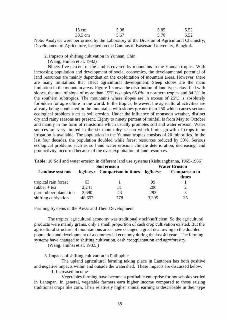
38
15 cm 5.98 5.85 5.52 30.5 cm 5.67 5.70 5.52 Note: Analyses were performed by the Laboratory of the Division of Agricultural Chemistry, Development of Agriculture, located on the Campus of Kasetsart University, Bangkok.
2. Impacts of shifting cultivation in Yunnan, Chin (Wang, Huihai et al. 1982) Ninety-five percent of the land is covered by mountains in the Yunnan tropics. With increasing population and development of social economics, the developmental potential of land resources are mainly dependent on the exploitation of mountain areas. However, there are many limitations that affect agricultural development. Steep slopes are the main limitation in the mountain areas. Figure 1 shows the distribution of land types classified with slopes, the area of slope of more than 15ºC occupies 65.6% in northern tropics and 84.3% in the southern subtropics. The mountains where slopes are in excess of 25ºC is absolutely forbidden for agriculture in the world. In the tropics, however, the agricultural activities are already being conducted in the mountains with slopes greater than 250 which causes serious ecological problem such as soil erosion. Under the influence of monsoon weather, distinct dry and rainy seasons are present. Eighty to ninety percent of rainfall is from May to October and mainly in the form of rainstorms which usually promotes soil and water erosion. Water sources are very limited in the six-month dry season which limits growth of crops if no irrigation is available. The population in the Yunnan tropics consists of 20 minorities. In the last four decades, the population doubled while forest resources reduced by 50%. Serious ecological problems such as soil and water erosion, climate deterioration, decreasing land productivity, occurred because of the over-exploitation of land resources. Table: 10 Soil and water erosion in different land use systems (Xishuangbanna, 1965-1966) Soil erosion Water Erosion
Landuse systems kg/ha/yr Comparison in times kg/ha/yr Comparison in times
tropical rain forest 63 1 99 1 rubber + tea 2,241 31 206 2 pure rubber plantation 2,690 43 293 3 shifting cultivation 48,697 778 3,395 35
Farming Systems in the Areas and Their Development
The tropics' agricultural economy was traditionally self-sufficient. So the agricultural products were mainly grains, only a small proportion of cash crop cultivation existed. But the agricultural structure of mountainous areas have changed a great deal owing to the doubled population and development of a commercial economy during the last 40 years. The farming systems have changed to shifting cultivation, cash crop;plantation and agroforestry. (Wang, Huihai et al. 1982. )
3. Impacts of shifting cultivation in Philippine The upland agricultural farming taking place in Lantapan has both positive and negative impacts within and outside the watershed. These impacts are discussed below.
1. Increased income Vegetables farming have become a profitable enterprise for households settled in Lantapan. In general, vegetable farmers earn higher income compared to those raising traditional crops like corn. Their relatively higher annual earning is describable in their type
39
of dwelling characterized by concrete materials and galvanized roofing. A number of households are able to purchase family vehicle for transporting their agricultural produce as well as for public conveyance.
2. Deforestation hile upland farming in Lantapan is economically promising it has other negative effects. The production of high value crops has served as pressure for the clearing of trees and eventual forest margin recession. Cultivation continues to move upslope to Mt. Kitanglad, a declared protected area and Natural Park. Once an area is cleared, it remains a cropland devoted to continuous cultivation.
3. Declining Biodiversity Study conducted by Dagondon et al. (1997), revealed that particular plants and animals are already at the threatened level because of critical land uses such as forest clearing and vegetable farming. The threatened species include birds, insectivores, arboreal mammals, microbats species and fern allies Dagondon, G., V. Amorsolo, B. Tabaranza, and V. Saway, 1997. “Upper Manupali
Watershed Biodiversity Research Conservation Program.” SANREM CRSP/P hilippine Project Report, 19 pp.
4. Site degradation and productivity decline ith the rolling terrain of the area, erosion and soil loss are evident particularly during the rainy season. This specifically results to nutrient loss and increase in soil acidity. For instance from a benchmark average ph level of 5.40 recorded in 1982 (FORI, 1982). This is now lowered at about 4.7. This necessitated the perennial application of commercial fertilizer to sustain productivity of vegetable crops. But the continues application of inorganic fertilizer has also resulted to adverse alteration in soil microorganisms. Beneficial microorganisms continue to be eliminated while their undesirable counterpart such as the causal agent of bacterial wilt in potato has persisted. FORI, 1982. “Hydrological and Physical Characterization of Muleta-Manupali Watershed
(Bukidnon).” Terminal Report. Los Baños, Laguna: Forest Research Institute.
5. Negative Impact on Irrigation System He widening cultivation for upland farming has also adverse effect on the irrigation system in terms of its delivery and volume. Sedimentation in irrigation canals has caused overflows and less efficient water distribution necessitating some occasional canal dredging operations. The amount removed from different canals from 1993-1995 was more than twice the amount removed in 1990 – 1992 (Singh et al., 1998) On the other hand, the substantial water consumption of the two corporate banana plantations in the upper slope has lessened the volume of irrigation water available for the lowland farmers such that the local irrigation federation has already filed a complaint with the local government unit. Singh V., G. Belarmino, S. Bhuiyan, L. Proce, and S. Kam, 1998. “Soil and Water
Resources Management and Conservation for Sustainable Production Systems in the Manupali River Watershed Bukidnon, Philippines.” Program Highlights, May 1998. SANREM CRSP (Philippines).
6. Pesticide contamination of rivers revalent spraying in vegetable production areas leads to increasing pollution problem of the river. Initial result of a study supported by SANREM indicates that samples taken from Maagnao and Tugasan River showed Cyclodiene concentrations (chlordane, dieldren, endosulfan) of about 1.1 to 2.5 ppb. This raises serious concerns to the state of aquatic ecosystem of Manupali watershed.
40
3.3.1 Impact of Shifting Cultivation in Lao PDR (Bouahong, DoF), (Boualy and Bounthay, NFES, SCSEC) March 2003: Impacts of
shifting cultivation. Deforestation through shifting cultivation is a serious impact because of direct
reduction of forests. Shifting cultivation is a complex activity that takes 6-7 mouths, but the yield is low, and it is not worth the investment, time and labor. Additionally, it has adverse impact on natural environment and several subsequent problems, as fallows:
1. Yearly, forests are deforested and lost resulting in decrease of forest cover 2. Hilly land areas deforested through shifting cultivation because areas without
forests, fallow land, imperator cylindrical grassland and degraded area. The soil gets in fertile, and no continuous production can be practiced. Even if production (shifting cultivation) with be continuously practiced, yields will be low and it is not worth the labor.
3. Natural environment and climate are changing and cause unusual warm weather, drought hazards and irregular rain.
4. There are adverse impacts on people’s livelihood. In particular, shifting cultivators get difficulties. They will increasingly spend more time for production and lack source of wild food from natural forests, construction wood and energy (fuel wood). Finally, they will migrate to other areas and not have permanent settlement.
Deforestation leads to lower water discharge in the dry season. Greater sediment loads and floods in the rainy season are of special concern to agriculture in the delta. Reduction of high density forest area, significantly above the sustainable rate of timber extraction – combined with the marked expansion of permanent agricultural land suggests that logging followed by eventual conversion of logged land into permanent agriculture land contributes appreciably to deforestation in the centre and the south. The focus on short term profit maximisation without commitment to sustained yield management will further exacerbate deforestation pressures.
1/ Economic loss (STEA 2000a): Because of Lao PDR’s dependence on forest resources for foreign
exchange earnings and as a source of economic growth, another important consideration is the degree of revenue loss from resource pricing and contract arrangements that fail to maximise rent capture from resource use.
Depletion of forest resources due to over harvest and illegal logging activities involves significant loss of government revenue. The estimated annual loss in government revenue due to illegal logging is $US 21 million (STEA 2000a). Declaring high value species as low value species at second landings and at the border exit points (in order to reduce logging and export taxes) is also a common practice. False specifications of species results in an annual loss in government revenue of $US 1 million (STEA 2000a).
2/ Number of families and area in practices shifting cultivation (DFNRV 1992): In 1995, there were 198,868 families practicing cultivation with an annual area cropped of 192,258 hectares. By 1998 the number had fallen to 140,800 with 142,785 hectares under annual crops. The reduction in long rotation shifting cultivation is occurring as both population pressures and containment of agricultural land lead families to adjust to shorter cropping/fallow rotations on reduced areas. A Department of Forestry National Reconnaissance Survey made in 1992 indicated the area under upland crops was 626,000 hectares in 1989. This compares to a slightly lower estimate made for 1982 of 590,000 hectares. Based on these figures, and the projected influence of population increase in upland communities, it is considered that year 2000 about
41
330,000 families cropping is in fact some form of shifting cultivation. Under 3 - 5 years rotation the total area of land used in the cycle is about 2-3 billion hectares. (DFNRV 1992)
3/ Forest fires and upland encroachment The impacts of forest fires and the encroachment of upland areas by lowland farmers also contribute to the depletion forest resources in Lao PDR. As previously stated, the Government estimates that shifting cultivation practices with concomitant forest fires clear about 300,000 ha of forest land. Encroachment of patches of forest land, cleared by upland farmers but left fallow, by formerly lowland cultivators also reduces upland fallow periods resulting to diminished upland land resources; thereby, triggering more forest clearing by the uplanders. These and other causes remaining officially unrecognized, the policy of reducing shifting cultivation will continue to cause hardship and hinder efforts to engender better management of logging activities (AusAID 1996). The expansion of permanent agriculture removes an estimated 30,000 ha per annum of forest area (STEA 2000a).
4/ Soil erosion Shifting cultivation has an effect on soil fertility change and nutrient loss from the system by erosion and runoff. Farmer practices of upland rice cultivation increase run off and thus soil and nutrient losses (Sengtaheuonghoung et al., 2001). They indicated that soil organic matter, available P and K tended to decrease with the cropping time. Roder (1995) suggested that higher soil and nutrient losses would be caused by the combined effect of soil physical (texture, clay type, water infiltration) and biological factors. 5/ Soil fertility Soil fertility is one of the constraints which influenced crop production in the tropics in general and for slash-and-burn system in particular (Jordan, 1985; Sanchez, 1987 and Warner, 1991). Most references on slash and burn agriculture in the Lao PDR cite soil fertility as a major constraint. Soil fertility is an important factor affecting upland rice yield. Upland farmers in Laos considere that the main factors affecting rice growth and yields are soil fertility and favorable rainfall. Upland farmers classify soil fertility by soil color and texture as black color and clayed are good soil(dindee); white, yellow and sandy are bad soil (din bo dee or din khi laie). Most of the soils in upland rice cultivated areas are loamy and clay texture. Gupta et al. (1986) suggested that fine-textured soil is the best for upland rice because it holds more water. Moormann and Veldkamp suggested that the abundant, sandy, coarse- textured soils in West African upland rice area limit rice production because of low water retention capacity. High clay content, as in Vertisols is also good soil for rice because it can supply sufficient water for rice. The black soil (dindam) would be higher in organic matter, good in structure, water holding capacity and good nutrient supply. The black soils would provide large amount of nitrogen and phosphorus to rice crops and give higher rice yield than white and yellow soils (Gupta et al., 1986). Since 1990s, the fallow length became shorter and the upland rice cycle and soil erosion increased. The soil became white or yellow in color or stony in texture and upland rice yield was reduced in each rice growing year. As a result of N uptake by rice crop and N losses, the pool of available N started to drop 30 days after rice was planted (Roder, 2001). During the time from burning to harvest, the organic matter and N in the top soil (0-25 cm) were lost (about 10,000 and 400 kg/ha, respectively). Tulaphitak et al. (1985) estimated a loss of 13,000kg of organic matter per ha in the first year after burning for slash and burn system in northern Thailand. During the cropping period from planting in May to harvest in October, organic carbon and extractable P decreased in all depths, but extractable K decreased only in the top soil layer and increased in the two sub soil layers (Roder, 2001). The average values of organic matter, total N, available P, available K and pH decreased over the season. Available P, available K and CEC did not show any relationship with rice yield
42
(Roder, 2001). In continuous cropping system, soil chemical and physical properties were changed such as pH decreased about 1 to 1.5 units and so were the amount of total N, exchangeable Ca and K. Soils in the slash and burn cultivation system, generally are low in organic matter, mainly red-yellow, podzolic and reddish brown lateritic, leached and acidic, with low water holding capacity and low N supply capacity and deficient in P (Gupta and O’Toole, 1986). In many upland soils of the tropics, P rather than N provides the main limitation to plant growth (Gijsman et al., 1996). Tulaphitak et al. (1985) reported that organic matter loss of 8.8% annually and estimated that 240 kg N, 20 kg P and 80 kg K would be released during the first year after burning due to the mineralization of soil organic matter. Mineralization of soil organic matter after burning is an important source of N for cultivated crops. It is agreed that soil organic matter plays a key role in achieving and maintaining the soil fertility level (Roder et al., 1997). Soil organic matter is not only a pool of plant nutrients; but and also affects soil physical, chemical and biological properties. Mineralization of organic matter, the major N source, was accelerated after burning of the tree biomass by increasing soil moisture and temperature. The pool of available N is highest at the time of rice planting (Roder, 1995). With gradual decline in the level of organic matter because of shorter fallow period (Figure 7), it is expected that N stress may become more accentuated and it may limit rice yield in the near future (Roder et al., 2001). The biomass of the fallow vegetation generally represents the major pool of potassium, Ca and Mg (Andriesse and Schelhaas, 1987; Nye and Greenland, 1960; Sanchez, 1987). Roder estimated that P, K, Ca and Mg are probably influenced by organic matter mineralization. Soil pH and extractable bases showed a faster decline in the topmost soil layer in the first year after burning a simultaneous increase in the lower soil layer (Figure 8 a). Extractable P and K increased towards the end of the fallow period. Most of the N and P are located in the soil (Andriese and Schelhaas, 1987; Sanchez, 1987). Roder suggested that plant nutrient concentration in soil were highest in the top 0-3 cm depth (Figure 8 & 9). This is largely due to the result of litter turnover, humus accumulation and ash deposits as has been documented in various environments (Andriesse and Schelhaas, 1987; Nye and Greenland, 1960). The study on burning of plant residues in this system indicated that soil pH, extractable P and K were increased in the top soil level (0-3 cm, Figure 9). In the soil dynamic observations, Roder suggested that the effect of biomass burning on soil pH and extractable nutrients are the result of ash deposits (Van Reuler and Jassen, 1993b) and therefore, depended on the available biomass quantity and its composition. Because of ash deposits and the effect of heat, most dynamic changes in the upper soil layer occur at the time of burning and the period immediately after burning (Sanchez et al., 1983; Seubert et al., 1977; Tulaphitak et al., 1985). The decrease in organic matter and N was accompanied by a substantial increase in available forms of N (NH4
+, NO3- and NO2
-). During the period from burning to planting of rice the average levels for these forms of N increased with increasing depths (down to 25 cm). Plant nutrients in the soil under the forest have two main storage areas. i.e, the biomass and the topsoil (Sanchez, 1976). Several authors have suggested that weeds play a positive role in shifting cultivation system by recycling of nutrients (Swamy and Ramakrishnan, 1988).
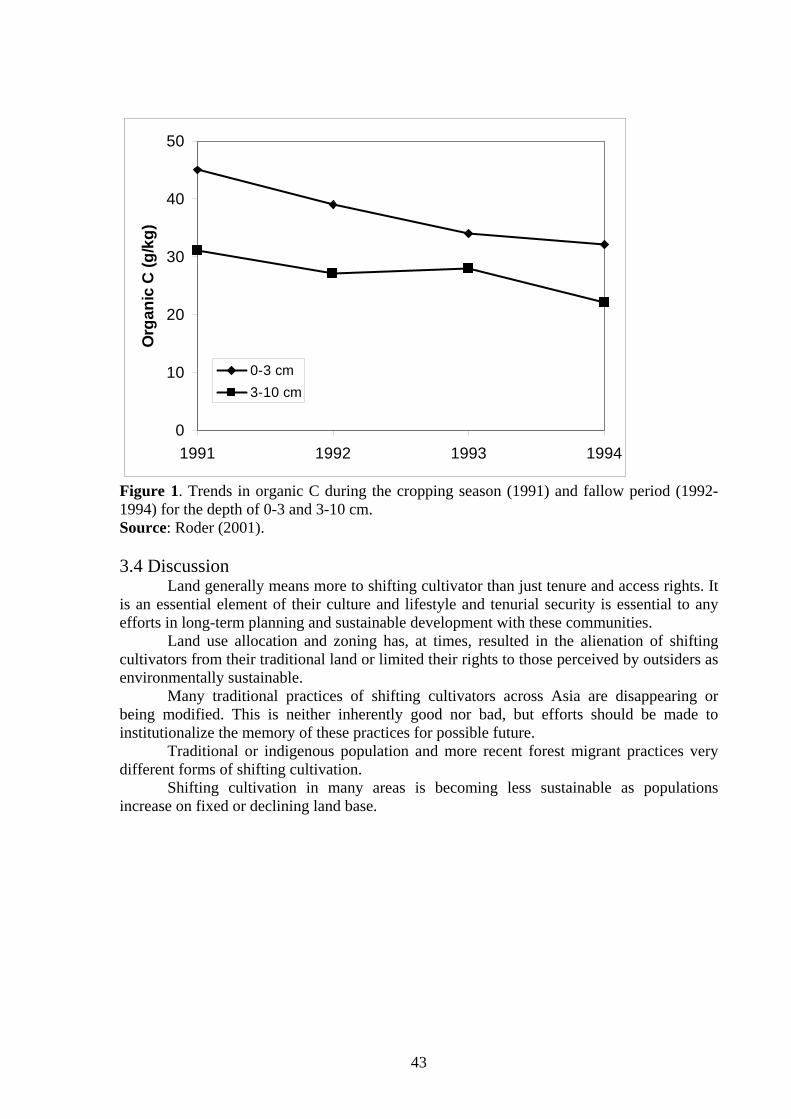
43
0
10
20
30
40
50
1991 1992 1993 1994
Org
anic
C (g
/kg)
0-3 cm3-10 cm
Figure 1. Trends in organic C during the cropping season (1991) and fallow period (1992-1994) for the depth of 0-3 and 3-10 cm. Source: Roder (2001). 3.4 Discussion Land generally means more to shifting cultivator than just tenure and access rights. It is an essential element of their culture and lifestyle and tenurial security is essential to any efforts in long-term planning and sustainable development with these communities. Land use allocation and zoning has, at times, resulted in the alienation of shifting cultivators from their traditional land or limited their rights to those perceived by outsiders as environmentally sustainable. Many traditional practices of shifting cultivators across Asia are disappearing or being modified. This is neither inherently good nor bad, but efforts should be made to institutionalize the memory of these practices for possible future. Traditional or indigenous population and more recent forest migrant practices very different forms of shifting cultivation. Shifting cultivation in many areas is becoming less sustainable as populations increase on fixed or declining land base.
44
CHAPTER IV
CONCLUSION AND RECOMAMDATION
4.1 Conclusion Some of the world’s poorest people in Asia live among communities that have
depended upon shifting cultivation for their livelihoods. In Asia, as well as in most tropical part of the world, shifting cultivation was the first form of agro forestry. Shifting cultivation usually slash and burn secondary forest or fallow and prepare the land for food crops. The total land area affected by shifting cultivation is difficult and practiced about 30 percent of the world’s exploitable soil. There is more then 400 million people practiced shifting cultivation in Asia. Shifting Cultivation in woodlands and hills, for instance, has six stages: (a) site-selection and clearing, (b) burning, (c) plating, (d) weeding and protecting, (e) harvesting, and (f) succession. Most counties in Asia are now confronted with the “problem” of shifting cultivation. Discussion and debate continues regarding the perceived positive and negative impacts of shifting cultivation even while million of resource-constrained farmer across the region persist with these practices.
From resulted of the study about shifting cultivation in some part of Southeast Asia include: Thailand, China, Philippine, and Northern part of Lao PDR. It can show different of data and method of shifting cultivation. Shifting cultivation in Northern Laos is under pressure to modify, their land use because of population growth, declining natural resources, and government regulations on land access. In area with good road and market access, many changes have taken place in the past 5 to 10 years, adoption of new cash crops, establishment of farmer owned teak plantations, and increased livestock production. However, in most of the Northern Region, a rapid transformation of shifting cultivation seems unrealistic considering its scale, the poverty of most shifting cultivation, the mountainous topography, the current institutional capacity, and the undeveloped market, infrastructure and processing industry. Shifting cultivation, having a considerable negative impact on the land and forest, is widely practiced. It is expected that such a negative impact may expand in future as a result of increased population pressure. Accordingly, taking measures to stabilize shifting cultivation is seen as critical for Agricultural development in this area. Among others, fundamental measures to be taken for shifting cultivation stabilization include the development of alternative production of such systems through the strengthening of research efforts and the dissemination of such systems to farmers through reinforcing extension services. Another fundamental measure is to provide an adequate rural road network in shifting cultivation areas. Development strategies and activities need to be flexible and diversified to suit the very variable environment, socio-economic conditions and land-use in mountainous areas. On a regional level, the main factors determining potential land-use improvement s are probably the agro-ecological conditions and road access. Although most development efforts have taken a technical approach, land use problems are rarely purely technical, nor are technical problems necessarily farmers’ main concern. Other problems equally or more important may be:
• Resource access, especially land and capital • Social problems and poverty • Market access because of the lack of roads, processing facilities, • Non-agricultural occupation:
45
4.2 Recommendation To day shifting cultivation in some part of Asia were practice by upland people and cover by land under shifting cultivation. There are many problems in upland to practice the shifting cultivation. Problem: Bio-Geographic condition Causes: - Due to steep slop, land opening with machines is difficult
- Due to small number of flat land, the permanent Agriculture land is not enough as needed
Recommendation: - Applying various techniques and methods changing the Agriculture system mainly the agro forestry system - Determining land uses for the production (Zoning management areas) and allocating land and forest to the farmers in each area - Building up irrigation system, where possible - Using the potential of the localities mainly the investment, seeds and
market, etc. Problem: Traditional livelihood Causes: - Superstition due to custom from the ancient time
- Seasonal production depending on nature - Limitation of application of technology, newly improved seeds and mechanics
Recommendation: - Propagation, education and making people aware of the necessity of poverty alleviation. - Introduce of techniques, seeds and production tools to the people. - Train people and improve their technical knowledge
Problem: Technology Causes: - Farmers still have limitation in applying technology
- Number of staff at the district level and their knowledge and skills are limited
Recommendation: - Establishing more development intervention areas and model households for the Agriculture and forestry production to create basis for knowledge transfer to the other farmers - Increasing staff number at district level , and train them regularly to improve their technical knowledge - Data or information related to the results of Agriculture and forestry should be disseminated.
Problem: Government policies and legislation Causes: - Resolution, orders, regulations and laws are still not strongly implemented
and enforced, as they should be. - Mechanism and policies on trade and investment in Agriculture are still not well implemented.
Recommendation: - Propagation and dissemination of spirits of legislation to the localities especially to the villages - Promotion of mechanism and policies on trade and investment appropriately - Establishment of bank credit system for agriculture and forestry.
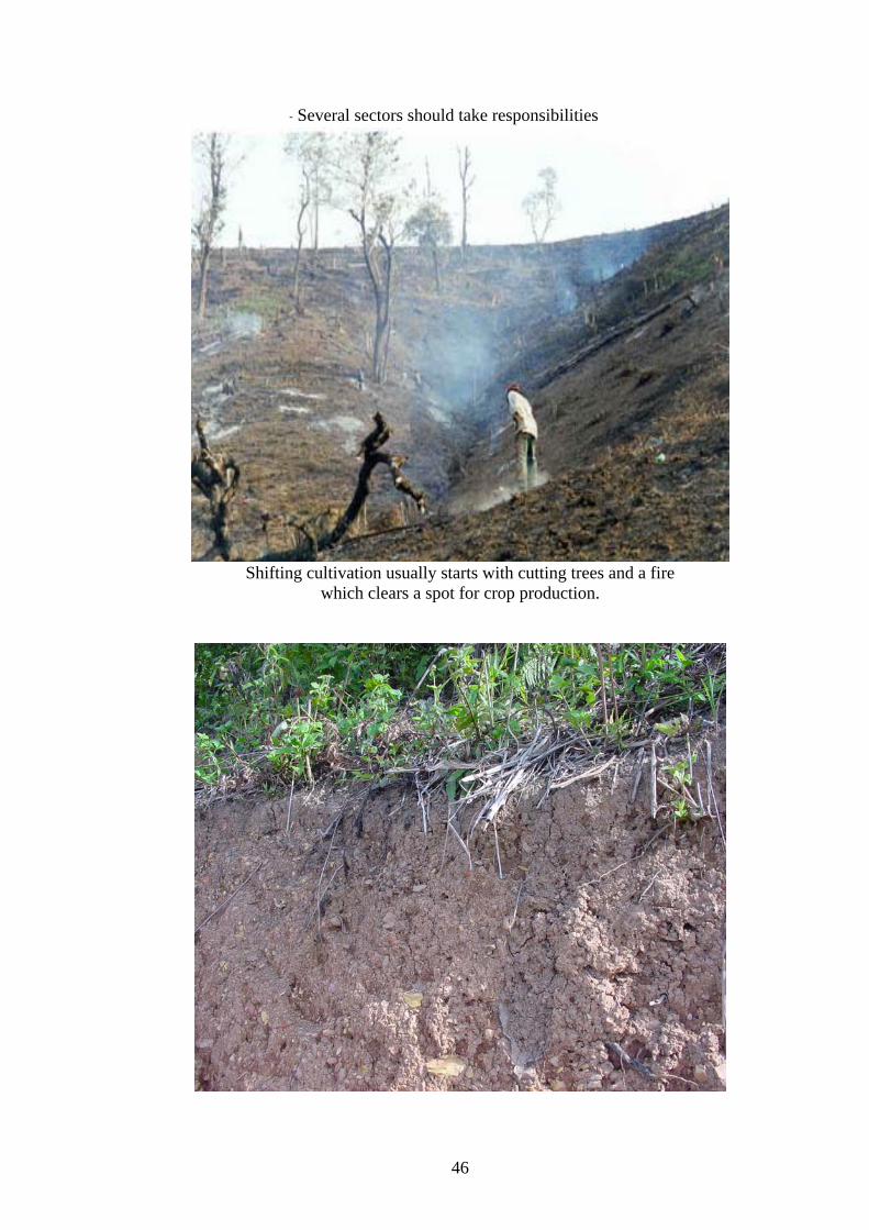
46
- Several sectors should take responsibilities
Shifting cultivation usually starts with cutting trees and a fire
which clears a spot for crop production.
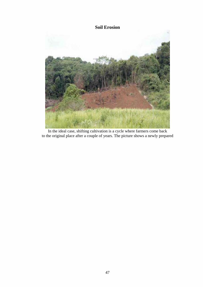
47
Soil Erosion
In the ideal case, shifting cultivation is a cycle where farmers come back
to the original place after a couple of years. The picture shows a newly prepared
48
Reference:
Academia Sinica's Editorial Committee of China's Nature Geography. 1984. China's nature geography, Sciences Press, Beijing. pp. 153.
AUSAID: 1996 Australian Agency for International Development
Bouahong Phanthanosy, (DoF) 2003: Department of Forestry Vientiane, March 2003. Boualy Phameung, (NAFES) 2003: National Agriculture and Forestry Extension Service,
Vientiane, March, 2003. Bounthay, (NAFES) 2003: National Agriculture and Forestry Extension Service,
Vientiane, March, 2003.
Bradley, David. 1975. "Lahu Dialects and Proto-loloish." Ph.D. dissertation. London University.
Castor, Nestor 1994a. Indigenous Knowledge as the Basis for Sustainable alternative Livelihood: The Case of the Hanunoo Farming System, In proceedings of the symposium /Workshop on sustainable Alternative Livelihood. Quezon City: FSDI
Conklin, Harold C. 1957. "A Report on an Integral System of Shifting Cultivation in the Philippines." Hanunóo Agriculture. Food and Agriculture Organization of the United Nations. Rome
Dagondon, G., V. Amorsolo, B. Tabaranza, and V. Saway, 1997. “Upper Manupali Watershed Biodiversity Research Conservation Program.” SANREM CRSP/Philippine Project Report, 19 pp.
DFNRV, 1992: Department of Forestry National Reconnaissance Survey in 1992
Draft Final Report Volume I, Ministry of Agriculture and Forestry of Lao People’s Democratic Republic
Dessaint 1972 Dessaint, Alain Yvon. 1972.''Economic Organization of the Lisu of the Thai Highlands." Ph.D. dissertation (Anthropology), University of Hawaii, Honolulu, Hawaii, USA.
FORI, 1982. “Hydrological and Physical Characterization of Muleta-Manupali Watershed (Bukidnon).” Terminal Report. Los Baños, Laguna: Forest Research Institute.
FAO, 1969 Community of Forest Development in the tropics (1969) Graham, 1924 W.A.1924. Siam. A. Moring, London Grandstaff, 1979''The Hmong, Opium. and the Haw: Speculations on the Origin of the Association." Journal of the Siam Society. 76 (2).
49
Geddes, 1976 Migrants of the Mountains. The Cultural Ecology of the Blue Miao (Hmong Njua) of Thailand. Clarendon Press, Oxford.
Gupta, P.C. and J.C. O’Toole. 1986. Upland Rice a Global Perspective. International Rice Research Institute. Los Banos, Philippines. Gijsman, A.J.; A. Oberson; H. Tiessen and D.K. Friessen. 1996. Limited Applicability of
the Century Model to highly weathered tropical soil. Agron. J. 88: 894-903.
Hansen, 1995: Shifting Cultivation Adaptation and Environment in a Watershed Area of Northern Thailand.
ISO, 97b information package as something that involves the precautionary approach compared to actual impacts (SC3 p 93 p7) [ISO 97b]
(IFAD, IDRC, CIIFAD, ICRF, and IIRR. 2001. Shifting Cultivation:) International Fund for Agricultural Development, International Development Research Center, International Institute For Food, Agriculture and Development, International Center for Research in Agro forestry and International Institute of Rural Reconstruction.) Jodan, C.F. 1985. Nutrient cycling in tropical forest ecosystem. John Willey and Sons, New York. Kunstadter, P. and Chapman (1978) Problems of Shifting Cultivation and Development
in northern Thailand.
Keen, F. G. B (1986): Land Use. In: Highlanders of Thailand (eds.: J. McKinnon and W. Bruksasri), p. 293-306. Oxford University Press, Singapore. 358pp.
Katutubo: Glimpses of Philippines Culture (CD-ROW) Makati: FHL
Lijima, 1970 Iijima, Shigeru. 1970.''Socio-cultural Change among the Shifting Cultivators through the Introduction of Wet Rice Culture-A Case Study of the Karens in Northern Thailand.'' Memoirs of the College of Agriculture, Kyoto University, No. 97. Agricultural Economics Series No. 3. Kyoto, Japan.
MAF: Ministry of Agriculture and Forestry: Vientiane: 1997 NEPED and IIRR. 1999 Building Upo Traditional Agriculture in Nagaland, India. Nagaland Environmental Protection and Economic development, Nagaland India and International Instituite of Rural Reconstruction, Silang, Cavite, 4118 Philippines. Phrang Roy and Ganesh Thapa of IFAD-Rome, Dennis Garrity; Chun lai and paul Burgers of ICRAF January 2001 Roder, W. 2001. Slash-and-Burn Rice Systems in the hill of Northern Lao PDR: Description Challenges and opportunities. International Rice Research Institute, 202 p.
50
Roder, W. S. Phengchanh and S. Maniphone. 1997. Dynamics of soil and vegetation during crop and fallow period in slash-and-burn field of northern Laos. Geoderma 76: 131-144.
Roder, W. S. Phengchanh and B. Keoboulapha. 1995. Relationships between soils, fallow
period, weed and rice yield in slash-and-burn system of Laos. Plant and Soil 176: 27-36.
Swammy, P.S. and P.S. Ramakrishsran. 1988. Ecological implication of traditional weeding and other imposed weeding regimes under slash-and-burn agriculture (Jhum) in northeasthern India. Weed research 28: 127-36. Singh, V. G. Belarmino, S. Bhuiyan, L. Proce, and S. Kam, 1998. “Soil and Water
Resources Management and Conservation for Sustainable Production Systems in the Manupali River Watershed Bukidnon, Philippines.” Program Highlights, May 1998. SANREM CRSP (Philippines).
Sengtaheuonghoung, O. and T. Phommasak. 2001. Management of Sloping Land in the
Lao PDR. In: Management of Sloping Land for Sustainable Agriculture. Final Report of ASIALAND, Sloping Land Project, phase 4. Edited by Frits Penning de Vries, March 2002.
Sanchez, P.A. 1987. Management of acid soil in the humid tropics of Latin America. In Management of Acid tropical, Soils for Sustainable Agriculture. Proceeding of an IBSRAM inaugural workshop, Bangkok. 63-107.
Sabhsri, Sanga 1968 Research project 27/5, Report No, Bangkhen, Bangkok: Applied Scientific Research Corporation of Thailand.
Sutthi, Chantaboon (1989): Highland Agriculture: from better to worse. In: Hill Tribes Today (eds.: J. Mckinnon and B. Vienne), p. 107-142. White Lotus – Orstom, Bangkok. 507pp.
Suderlin, W.D1997 Shifting cultivation and deforestation in Indonesia: Steps Toward Overcoming Confusion in the Debate. Mailing 21, Rural Development Forestry Network, Overseas Development Institute. STEA : Science, Technology and Environmental Agency 2000s Tulaphitak, T. C. Pailintra and K. Kyuma. 1985. Change in soil fertility and tilth under shifting cultivation. II. Change in soil nutrient status. Soil Sci. Plant Nutr. 31: 227- 238.
T.R.I, (1986): The hill tribes of Northern Thailand, Tribal Research Institute, Chiang Mai.
TRC, 1974 Tribal Research Centre, UNDP: Vientiane 1994 United Nations Development Programme
51
Van Reuler, H. and B.H. Janssen. 1993b. Nutrient fluxes in the shifting cultivation system of South-west cote d’Ivoire. II. Short-term and long-term effect of burning on yield and nutrient uptake of food crop. Plant and Soil, 154: 179-188. WRI: World Resources Institute. September 1997
Walker, Anthony R., ed. 1975. Farmers in the Hills: Up/and Peoples of North Thailand University Sains Malaysia. Penang, Malaysia.
Wang, Huihai et al. 1982. The exploitation of tropical rain forest in relation to soil and water conservation in southern Yunnan. Scientic Silvae Sinicae 8(3): 245 - 257.
Warner, K. 1991. Shifting cultivators-local technical knowledge and natural resource management in the humid tropics. Community forestry note 8. FAO, Rome. 80 p.