Achieving an Integrated Open Space Network in Detroit · Joy-Southfield Community Development...
87
Achieving an Integrated Open Space Network in Detroit April 14, 2016
Transcript of Achieving an Integrated Open Space Network in Detroit · Joy-Southfield Community Development...
Achieving an Integrated Open Space Network in DetroitApril 14, 2016

2 DETROIT FUTURE CITY - APRIL 14, 2016
ACKNOWLEDGMENTS
Detroit Future City would like to acknowledge the many organizations who provided input and feedback into this report:
Black Family DevelopmentCenter for Community ProgressCity of Detroit, General Services DepartmentCity of Detroit, Legislative Policy DivisionCity of Detroit Planning and Development DepartmentCommunity Development Advocates of DetroitDetroit Audubon SocietyDetroit Food Policy CouncilDetroit Greenways CoalitionDetroit Water and Sewerage DepartmentDetroiters Working for Environmental JusticeECN and LAND Inc on behalf of the Lower Eastside Action Plan (LEAP)Erb Family FoundationFocus: HopeFoodPlus DetroitGrandmont Rosedale Development CorporationHuron Clinton MetroparksJoy-Southfield Community Development CorporationKeep Growing DetroitMichigan Community ResourcesMSU Land Policy InstituteNortown CDCOjibway Prairie ComplexProSeeds ConsultingSoutheast Michigan Council Of Governments (SEMCOG)The Greening of DetroitThe Nature ConservancyUrban Development CorporationUSNAPBACWe Care About Van Dyke/ Seven Mile
We would also like to thank our funders, who made this work possible:
Michigan State Housing Development AuthorityThe Kresge Foundation
Document Prepared by:Detroit Future City Implementation Office2990 W Grand Blvd, Suite 2Detroit, MI 48202(313)259-4407 [email protected]
3
TABLE OF CONTENTS
TABLE OF CONTENTS
ACKNOWLEDGMENTS 2EXECUTIVE SUMMARY 5INTRODUCTION 13Overview 13Detroit Future City Strategic Framework 14Why is Open Space Important? 16Open Space Planning 22BACKGROUND 25Current Conditions 25Existing plans, policies, and organizations 28Detroit Future City Relevant Work 30STAKEHOLDER INPUT 33POTENTIAL OPEN SPACE TYPES 35Natural Areas 36Green Stormwater Infrastructure 46Productive Uses 48Parks and Recreation 56Buffers 59LAND OWNERSHIP, ASSEMBLY, AND DISPOSITION 65Ownership 65Assembly and Disposition 70FUNDING AND FINANCING 73POLICY AND LEGAL CONSIDERATIONS 77CONCLUSION 81END NOTES 83
4 DETROIT FUTURE CITY - APRIL 14, 2016
Executive Summary
5EXECUTIVE SUMMARY
EXECUTIVE SUMMARY
No other action or intervention has more potential to transform Detroit than turning the city’s vacant land liability into an open space amenity that: · Replaces costly and often overwhelmed gray infrastructure with Green Stormwater
infrastructure to manage storm water runoff; · Cleans air and soil with vegetation; · Generates food, jobs, energy, and commerce; · Stabilizes neighborhoods by reducing blight; · Connects neighborhoods and employment districts to open space through greenways; and · Provides opportunities for recreation and play.
The social, environmental, and economic benefits of transforming Detroit’s vacant land, which is currently more than 23 square miles and growing every day as the city continues in its blight remediation efforts, into an innovative open space network has the potential to create a new green and sustainable city unlike any other in the world that will improve quality of life for all Detroiters.
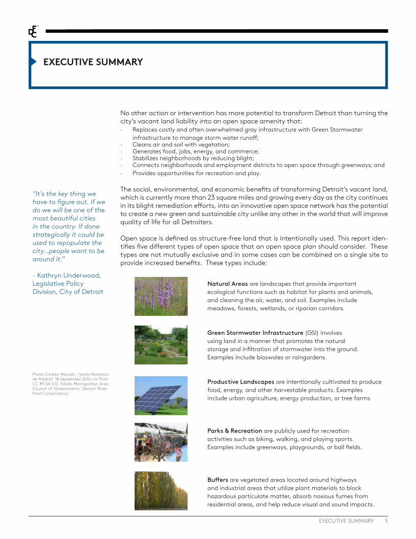
Open space is defined as structure-free land that is intentionally used. This report iden-tifies five different types of open space that an open space plan should consider. These types are not mutually exclusive and in some cases can be combined on a single site to provide increased benefits. These types include:
“It’s the key thing we have to figure out. If we do we will be one of the most beautiful cities in the country. If done strategically it could be used to repopulate the city…people want to be around it.”
- Kathryn Underwood, Legislative Policy Division, City of Detroit
Natural Areas are landscapes that provide important ecological functions such as habitat for plants and animals, and cleaning the air, water, and soil. Examples include meadows, forests, wetlands, or riparian corridors.
Green Stormwater Infrastructure (GSI) involves using land in a manner that promotes the natural storage and infiltration of stormwater into the ground. Examples include bioswales or raingardens.
Productive Landscapes are intentionally cultivated to produce food, energy, and other harvestable products. Examples include urban agriculture, energy production, or tree farms
Parks & Recreation are publicly used for recreation activities such as biking, walking, and playing sports. Examples include greenways, playgrounds, or ball fields.
Buffers are vegetated areas located around highways and industrial areas that utilize plant materials to block hazardous particulate matter, absorb noxious fumes from residential areas, and help reduce visual and sound impacts.
Photo Credits: Manuel., “jardin Botanico de Madrid” 18 September 2012 via Flickr CC BY-SA 2.0; Toledo Metropolitan Area Council of Governments; Detroit River-front Conservancy;

6 DETROIT FUTURE CITY - APRIL 14, 2016
Morton Arboretum Woodland
Photo Credit: Wikimedia
This report lays out existing conditions, stakeholder feedback, key planning consider-ations for each potential type of open space, recommendations for land ownership models, considerations for funding the open space network, and key policy, regulatory, and legal considerations.
Of all the recommendations and considerations offered in this report, the single most critical action Detroit can take to ensure the feasibility of a long-term open space network is to craft and adopt a comprehensive Open Space Plan, Master Plan of Policies, and Zoning Ordinance that detail and codify permanently designated open space areas.
DFC’s outreach to stakeholders, who are currently working in vacant land transformation, identified that there are key steps that need to be taken to further the implementation of an open space network. A key theme that was highlighted from this stakeholder en-gagement was the need for a plan for how to achieve the open space network, including clear policies and regulations to ensure implementation over time.
Stakeholders expressed that an open space plan needs to: · Designate open space in the Master Plan of Policies, a city-wide open space
plan, and integration into the Zoning Ordinance, with some flexibility to create neighborhood level decisions about types of open space.
· Permanently protect critical portions of the open space network · Ensure nature, food systems, and health are incorporated · Ensure the open space network connects throughout the city · Provide guidelines for different types of open space, including location
considerations and the amount of land that should be set aside for different types of open space.
· Allow the community to shape the plan through robust community engagement and ensure the plan addresses the concerns of people in Detroit.
Stakeholders also identified the lack of clear policy and regulation as key barriers and issues that are preventing the creation of an open space network, including the need for:
· Transparent and streamlined policies and procedures for site control and access to land. People want to know how to get access to land, either lease or purchase, and how these decisions are made. In order for people to invest in land, they need certainty around site control
· Policies and standards to ensure quality of demolition and post demolition in order to set the community up for success for transforming vacant lot.
· Resources, including money, to make sure the open space network is achieved. Communities need resources to be stewards of land, but also larger agencies and organizations need resources to manage land at a larger scale.
The range of types of open space also present a unique set of implementation consider-ations. Each type has its own set of site requirements that should be considered when planning for open space. The following pages summarize some of the key considerations in a comprehensive open space plan.

7EXECUTIVE SUMMARY
Open Space Case Studies
SOLAR STRAND, BUFFALO, NY
The Solar Strand at the University of Buffalo is a solar project that has the potential to be a model for solar projects in the urban environment. This solar project is built on 4 acres of the University of Buffalo campus. What sets the Solar Strand apart from other solar projects is that it is focused on much more than the generation of renewable energy. This project creates a multidimensional space that is used by a wide range of groups. In addition to the solar panels, the site features meadow plantings and walkways between rows that allow this solar installation to engage with the community at large.
OJIBWAY PRAIRIE COMPLEX, WINDSOR, ONTARIO
Located within the city limits of Windsor, the 600 acre Ojibway Prairie Complex preserves several rare ecosystems, such as tall grass prairie and Oak Savanah, and is home to more than 160 provincially rare plant and animal species.Located just 5 minutes from Downtown Windsor the Ojibway Prairie Complex provides easy access for Windsor Residents to a high quality natural experience.
SAGINAW FOREST, ANN ARBOR, MI
Saginaw Forest is a nearly 80-acre parcel of land comprised of roughly 55 acres of forested area, Third Sister Lake, and surrounding wetlands. The property, a gift to the University of Michigan in 1903, is used for forestry operations, research and instruction by the School of Natural Resources and Environment. The forest is located in the City of Ann Arbor, and it is open to the public for recreational purposes. Saginaw Forest is an example of how forests can be incorporated into the urban environment, providing significant ecological benefits, environmental health benefits, and recreational opportunities.
FRESH COAST CAPITAL
Fresh Coast Capital is real estate development firm that specialized in reutilizing vacant properties into working landscapes such as tree farms. The current focus is on growing hybrid poplar, which in addition to the reuse of the land may have additional benefits, including air quality, remediating soil and an increased ability to manage stormwater.Fresh Coast currently has projects underway in cities across the Midwest including, Gary IN, Elkhart IN and Flint MI.

8 DETROIT FUTURE CITY - APRIL 14, 2016
FORESTS · Expand tree planting programs to increase the overall tree canopy within the city. · Prioritize tree plantings in areas with high concentrations of vulnerable populations. · Expand and improve existing forest patches throughout the city. · Incorporate passive recreational opportunities when creating forested areas. · Consider the creation of larger scale, contiguous forested areas, which provide greater ecological benefits and
are better suited for habitat.PRAIRIES & MEADOWS
· Consider larger more contiguous areas for meadows and prairies as they have greater potential to provide habitat for many species of grassland birds.
· Consider land ownership and maintenance models that allow for the preservations of permanent open space. · Prioritize creating habitat for rare and endangered species. · Incorporate the creation of meadows and prairies into Detroit’s larger green stormwater infrastructure strategy
WETLANDS · Preserve and protect existing wetlands in Detroit · Restore wetlands where feasible · Create new wetlands as part of the open space network and as part of new development · Prioritize the creation and restoration of wetlands in riparian corridors on the Rouge River and Detroit River,
increasing the amount of Great Lakes coastal wetlands. · Incorporate wetlands as an important part of the larger stormwater management strategy for Detroit.
RIPARIAN CORRIDORS · Preserve and protect natural, vegetated riparian corridors along the Rouge River and Detroit River · Restore and re-vegetate areas along the Rouge and Detroit Rivers · Work to create a continuous vegetated riparian buffer along the Rouge · Incorporate natural riparian buffers along the Detroit River in all park and recreational areas and with all new
development · Pursue opportunities to daylight streams and creeks where appropriate · Whenever feasible, use vacant land to restore riparian corridors in Detroit.
Summary of Considerations for Potential Open Space Types
· Incorporate green stormwater infrastructure throughout all areas of the city · Utilize vacant land to implement green stormwater infrastructure, particularly in areas of transformation and
areas of stabilization. · Use green stormwater infrastructure elements that work well in high density environments in areas of growth. · Prioritize green stormwater infrastructure in locations adjacent to areas with high amounts of impervious
surface. · Incorporate green stormwater infrastructure throughout the open space network, including having standalone
GSI and incorporating it into parks, natural area, and productive areas.
URBAN AGRICULTURE · Support the existing urban agriculture ordinance by creating a review process for farms over one acre. · Create a fair and transparent process for accessing public land (through ownership and lease) for urban
agriculture. · Ensure leadership, funding, and policy facilitates and encourages urban agriculture as a permanent land use in
Detriot. · Consider proximity to supportive uses related to processing and packaging, especially for larger scale farming
activities in order to leverage the full economic opportunity of the food system.
Green Stormwater Infrastructure
Productive Uses
Natural Areas
9EXECUTIVE SUMMARY
Parks and Recreation
SOLAR ENERGY PRODUCTION · Set an overall community target for moving to renewable energy such as achieving 100% renewable energy by
2050. · Consider a mix of solar development scales, prioritizing larger areas of open space for utility-scale solar
development while examining smaller, neighborhood-scale solar development in residential areas with higher vacancy;
· Pursue regulatory changes that facilitate solar implementation within Detroit; · Promote the implementation of community net-metering programs to allow a wide range of Detroit residents
to access the benefits of solar development; · Prioritize areas with access to infrastructure for solar development; · Set clear goals for municipal purchase of renewable energy such as Grand Rapids and its target of going 100%
renewable by 2020. BIOFUEL, TREE FARMS AND OTHER PRODUCTIVE USES
· Ensure productive uses such as biofuel, cut flowers, or tree farms are integrated into the community in a way that improves quality of life.
· Ensure productive uses are not located in environmentally critical areas, where natural areas should be prioritized.
· Identify and designate areas where large scale productive uses (over 5 acres) are appropriate and desired by the community, such as transformation areas designated as Innovation Ecological or Innovation Productive
· Incorporate screening and transitions between uses as needed in siting proactive uses to ensure adjacent land uses are not negatively impacted from noises or smells.
PARKS · Incorporate recommendations and policies from the City’s Parks and Recreation Master Plan into the Open
Space Plan · Use vacant land adjacent to parks to expand parks. · Prioritize the creation of new parks in areas that are underserved by parks in Growth and Stabilization areas. · Identify and preserve land in areas experiencing development pressure to ensure residents have access to park
space. · Use parks in highly vacant areas for Green Stormwater Infrastructure or other open space projects.
GREENWAYS · Incorporate all existing greenway and non-motorized efforts into the open space plan. · Continue to expand non-motorized infrastructure to connect the open space network with other destinations. · Utilize vacant land, extra right-of-way capacity, or existing parks and open spaces to create an interconnected
greenway system · Identify vacant land within 500 feet of freeways for planting carbon buffers. · Work with all appropriate transportation agencies to begin planting carbon forests along freeways in the public
right-of-way, where feasible.
Buffers
· Identify vacant land within 500 feet of freeways for planting carbon buffers. · Identify vacant land adjacent to industry in residential neighborhoods that could be planted with forested
buffers. · Update zoning requirements for industrial development to require forested buffers for new industrial
development locating adjacent to residential property. · Incorporate evergreen and deciduous trees in all buffers to ensure the seasonal interest and environmental
benefits. · Incorporate greenways into buffers where appropriate.
Productive Uses (continued)

10 DETROIT FUTURE CITY - APRIL 14, 2016
One key question in the implementation of a larger integrated open space network is who will own and maintain each part of the network. While there is not one “right an-swer” to this question, rather there are several options that can be used in each unique situation to further the goal of reusing land within the city of Detroit. As part of this work the Center for Community Progress explored ownership options for open space in the report “Open Space in Detroit: Key Ownership and Funding Considerations to Inform a Comprehensive Open Space Planning Process” (CCP Report). This report focuses on two broad categories of ownership, public and private. The public models include city ownership, land bank, metropolitan district, or the MDNR. The CCP Report also explores private ownership options such as land trusts or land conservancies, community land trusts, land cooperatives, or private individuals or companies. There are also several legal tools that can be used to implement an open space network. These include deed restrictions, conservations easements, leases and development rights agreements.
In addition to an approach for land ownership, there is also a need for a strategic ap-proach to the assembly and disposition of this land to maximize its potential in the creation of an open space network. Key recommendations include:
· Assemble vacant land for buffers in areas adjacent to expressways and industrial corridors.
· Identify key areas for open space amenities in areas experiencing development pressure.
· Prioritize smaller scale open space types and sidelot disposition within traditional residential areas.
· Hold and assemble sites for open space uses that can be integrated into neighborhoods with moderate levels of vacancy.
· Assemble sites for large scale permeant open space in areas with high degrees of vacancy.
There is also a need for a diverse and strategic approach to funding the open space network. The CCP Report provides an overview of potential funding needs and funding sources as well as considerations to improve the financial feasibility of long-term open space broadly. It is clear that there is no one single funding source that will be needed in implementing an open space network, but rather a range of funding streams that will vary depending on the type of open space.
Photo Credit: University of Michigan

11EXECUTIVE SUMMARY
This report can be used as a platform to inform city-wide open space planning, com-munity level open space planning, as well as open space implementation projects at all scales. It can also be used as an advocacy tool with elected officials and community leaders and as a resource to support grant applications and conversations with funders to support on-the-ground implementation.
The open space network will not be achieved without action. The following actions must be taken in order to achieve an integrated open space network in Detroit: · Create an open space plan with robust community engagement · Integrate the open space vision into the Master Plan of Policies and Zoning to enable
implementation over time · Incorporate all types of open space into the network in a balanced way to achieve the
community’s overall goals and objectives based on the community’s values · Create clear policies and procedures to provide access to publicly owned land to
individuals and groups that are working to achieve the vision laid out in the open space plan
· Pursue appropriate ownership models and funding techniques that will best aid in the creation of the open space network over time
· Work to aggregate and consolidate vacant land to facilitate the creation of open space · Support pilot projects that test new ideas and work to integrate these pilot projects
into the larger open space network · Continue to support people and projects that are already working to implement vacant
land transformation
No one organization or agency can do this on their own. We must all work togeth-er to create and achieve the vision for open space in Detroit. A coordinated advocacy campaign is needed across a wide variety of organizations to educate and inspire the public and elected officials on the benefits of an integrated open space network and to advocate for citywide policy and regulatory reform that enables and supports the work of a range of groups, from citywide organizations implementing large scale projects to residents greening individual lots. Our collective action will improve quality of life for all Detroiters and create an open space legacy for generations to come, creating a green and sustainable city unlike any other in the world.
Photo Credit: M. Shaouni

Introduction1
Photo Credit: Andrew Potter
13
INTRODUCTION1
SECTION 1 : Introduction
Inside this Section
13 Types of Open Space
14 Detroit Future City Framework
16 Why is Open Space Important?
22 Open Space Planning
OVERVIEWThe scale and poor condition of Detroit’s massive vacant land portfolio – totaling more than 23 square miles – is often cited as one of Detroit’s greatest liabilities. Yet, this land has the potential to be transformed into an open space asset, establishing the city as a leader in innovative open space land uses.
Detroit’s population has declined over sixty-one percent since 1950. As a result of this population loss Detroit has been faced with large scale abandonment and vacancy. Much of Detroit’s water, air, and soil is polluted as a result of Detroit’s industrial legacy and its remaining industry. Current infrastructure systems are over-scaled and unsus-tainable, built to accommodate populations more than twice the size of the city’s cur-rent population.1 Unlike other cities pressed to find available land to provide sufficient open space, Detroit’s portfolio of vacant land can be leveraged to create a new green and sustainable city unlike any other in the world.
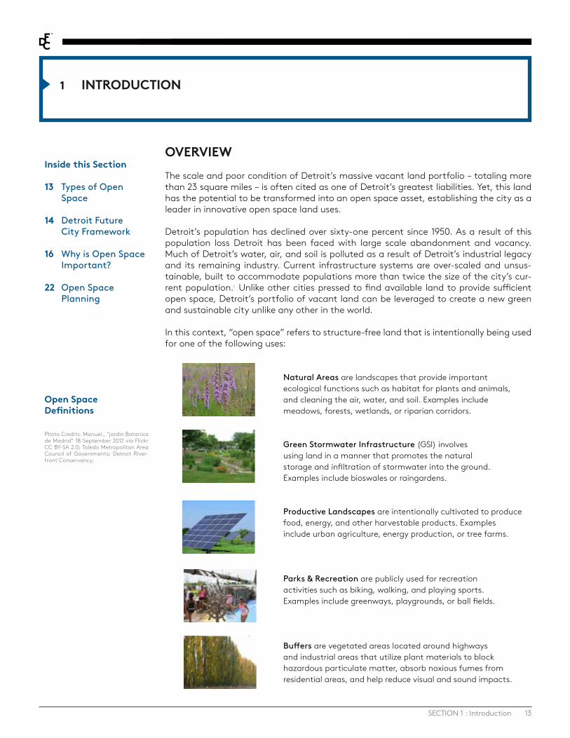
In this context, “open space” refers to structure-free land that is intentionally being used for one of the following uses:
Open Space Definitions
Photo Credits: Manuel., “jardin Botanico de Madrid” 18 September 2012 via Flickr CC BY-SA 2.0; Toledo Metropolitan Area Council of Governments; Detroit River-front Conservancy;
Natural Areas are landscapes that provide important ecological functions such as habitat for plants and animals, and cleaning the air, water, and soil. Examples include meadows, forests, wetlands, or riparian corridors.
Green Stormwater Infrastructure (GSI) involves using land in a manner that promotes the natural storage and infiltration of stormwater into the ground. Examples include bioswales or raingardens.
Productive Landscapes are intentionally cultivated to produce food, energy, and other harvestable products. Examples include urban agriculture, energy production, or tree farms.
Parks & Recreation are publicly used for recreation activities such as biking, walking, and playing sports. Examples include greenways, playgrounds, or ball fields.
Buffers are vegetated areas located around highways and industrial areas that utilize plant materials to block hazardous particulate matter, absorb noxious fumes from residential areas, and help reduce visual and sound impacts.

14 DETROIT FUTURE CITY - APRIL 14, 2016
DETROIT FUTURE CITY STRATEGIC FRAMEWORKThe need to transform Detroit’s vacant land into a new and multifaceted open space system is at the heart of the Detroit Future City: 2012 Detroit Strategic Framework Plan (DFC Strategic Framework), a city-wide plan culminating from three years of intensive community-driven research, collaboration, and analysis, which resulted in a shared vision for Detroit. The Framework establishes a set of policy directions and actions designed to improve quality of life for all Detroiters and support fiscal sustainability for the city, by strategically coordinating investments and resources related to economic growth, land use, neighborhoods, city systems, and public land and building assets. This shared vision for Detroit asserts that by 2030, the city will have a stabilized population and twice the number of jobs currently available to residents. With a stabilized population less than half the size it once was, but with the land area of the city staying the same, the city will have a new land use pattern with vacant land transformed into an open space network that serves as an amenity for all Detroiters. Economic growth will be focused in employment districts located strategically throughout the city, building on existing economic assets. Increased residential density will be focused in district and neighborhood centers, traditional neighborhoods will be stabilized, and innovative green neighborhoods will be supported. Strategic capital investment and maintenance plans in city systems and services will allow for greater residential density, more efficient use of resources, and improved ecological performance. Together, these outcomes can yield unique value proposition to residents and businesses.
The future land use vision for Detroit consists of a strategy that falls into three key areas:
· Areas of growth include employment districts located strategically throughout the city, building on existing economic assets as well as mixed-use areas designated as city center, district center, or neighborhood center, where increased residential density will be focused.
· Areas of stabilization include areas designated as traditional and green residential neighborhoods. These areas will be stabilized and continue to be the residential core of the city.
· Areas of transformation include areas designated as innovation ecological and innovation productive. With the greatest amount of vacant land, these areas will continue to support residents, but will focus on transforming vacant land into open space.
The Detroit Future Strategic Agenda can be used to inform citywide strategy to drive density and growth, stabilize neighborhoods, and transform vacant land into an open space asset.
The DFC Strategic Framework establishes a set of policy directions and actions designed to improve quality of life for all Detroiters.

15SECTION 1 : Introduction
This strategic approach to these three areas must occur simultaneously and symbiotical-ly in order to be successful. Specifically, a targeted growth strategy will not be success-ful without taking the vast vacant land liability off-line and transforming into an open space asset. At the same time, neighborhoods will not be stabilized without improving quality of life through vacant land transformation and necessary economic growth to provide jobs and commercial amenities for residents.
The future land use vision for Detroit includes an integrated open space network that transforms vacant land into an open space amenity. The network will connect all areas of the city, improving quality of life for all Detroiters. This vision for an open space plan does not mean that people will be forced to move our of their homes from a high va-cancy area. Instead, this vision is focused on improving quality of life and addressing the extreme levels of vacancy in some areas of the city.
In order to create a complete, connected network of open space in Detroit, there will be different types and different scales of open space throughout the city. While large-scale open space will be focused in areas of transformation, areas of stabilization will also include significant vacant land transformation, ranging from single lot transformations in Traditional Residential neighborhoods to larger open spaces integrated into Green Residential neighborhoods, where moderate levels of vacancy exist. Areas of Growth will also preserve and add open space, primarily in the form of parks and recreation areas, especially in mixed-use areas where open space will be critical to contribute to a high quality of life in high density residential areas. The network will connect areas of growth, transformation, and stabilization through greenways and buffers.
The DFC Strategic Framework provides a high-level, conceptual vision for open space in Detroit, but more work needs to be done to create an open space network. In order to seize the opportunity to intentionally transform vacant land into an amenity, deci-sion-makers at all levels need to understand why open space is important to Detroit and that it will not just happen on its own. An intentional, participatory process to plan for open space is needed to set policies, guide decision-making, and prioritize implemen-tation strategies. Without active planning and implementation efforts, vacant land will continue to detract from quality of life in Detroit.
Future Open Space Network
Open space strategies can be used to address 5 of the 13 Quality of Life elements in the DFC Strategic Framework.

16 DETROIT FUTURE CITY - APRIL 14, 2016
WHY IS OPEN SPACE IMPORTANT?No other action or intervention represents such enormous potential to transform Detroit with immediate and accessible opportunities than turning the city’s vacant land liability into an open space amenity that: · Replaces costly and often overwhelmed gray infrastructure with Green Stormwater
infrastructure to manage storm water runoff · Cleans air and soil with vegetation · Generates food, jobs, energy, and commerce · Stabilizes neighborhoods by reducing blight · Connects neighborhoods and employment districts to open space through
greenways · Provides opportunities for recreation and play
Many contemporary researchers have cited the benefits of having open space in urban areas that is accessible to vulnerable and dense populations. Detroiters have known this to be inherently true as they work to transform the lot next door, create community open spaces, adopt parks, or plant gardens. Of the 13 quality of life elements outlined in the DFC Strategic Framework, at least five can be improved through the creation and access to open space, including health, community, physical condition, environment, and rec-reation. Transforming vacant land into an open space amenity has the potential to also indirectly improve safety, prosperity and income, public services, mobility, and culture.
Transforming vacant land into an open space amenity will create social, economic, and environmental benefits for Detroit, creating a more sustainable and attractive city for all. As Detroit begins to rebound, now is the time to support the existing and future work of Detroiters and set aside permanent and interim open space that will serve the city for generations to come.
Social BenefitsFrom a social perspective, open space provides the opportunity to drastically improve quality of life for Detroiters. A significant portion of Detroit’s population could be con-sidered a vulnerable population, defined as minorities, elderly, youth, and those with low incomes. From a regional perspective, there are large concentrations of vulnerable populations within Detroit, particularly minority populations and those with low income. While there is a concentration of vulnerable populations within Detroit, much of the region’s open space assets are located outside the city. Open space within Detroit has the opportunity to provide key social benefits for these vulnerable populations, including health, physical condition, safety and overall sense of community.
HEALTHTransforming vacant land provides physical health benefits as well as psychological ben-efits from transforming vacant land into an open space amenity. Age, income, and mi-nority status place some residents at a disproportionately greater risk of adverse health impacts caused by environmental hazards.
Detroit has significant public health issues, including the fact that 14.8% of the children in Detroit suffer from asthma,2 69.1% of Detroiters are obese or overweight, and deaths resulting from heart disease in Detroit are 50% higher than the national average.3 An integrated open space network can begin to address some of these serious public health threats.
By incorporating trees and vegetation into vacant land transformation activities, pollu-tion can be reduced by absorbing airborne pollutants as well as helping filter pollutants
“Intentional open spaces can turn excess land into an amenity, increase property values around it, provide incredible public and mental health benefits, relieve some of the pressure on recreation centers by providing outdoor recreation, and help capture the true value of our abundant land by actually using it productively.”
-Sandra Stahl, Loveland Technologies
17SECTION 1 : Introduction
from soil and water, which will have a significant, long-term impact on asthma and other public health outcomes in Detroit. Carbon buffers along highways and industrial buffers can block particulate matter and filter pollution. Green cover and urban forests can also moderate temperatures by providing shade and cooling an area, thus helping to reduce the risk of heat island effect and heat-related illnesses in the city. 4
By using vacant land for renewable energy generation such as solar power, Detroit has the ability to address a root cause of asthma and other air-quality related health issues by providing a clean alternative to the region’s older, coal fired power plants. Michigan uses coal for 50% of its energy generation,5 and a 2011 study by the Michigan Environ-mental Council found that Michigan’s older coal-fired plants, cost Michigan residents $1.5 billion annually in health care costs. Replacing these coal plants could prevent some or all of the illness and death they cause in Michigan: 180 premature deaths, 233 hospital admissions or emergency room visits, 68,000 asthma exacerbations and 72,000 instanc-es in which children were restricted from school or some other activity.6
A large epidemiological study found a positive correlation with increased access to open space, such as parks and natural areas, and improvements in health. It also found that wealthier individuals were generally healthier than individuals with lower income, pri-marily because wealthier individuals reside in areas with more open space. The study concluded that physical environments that promote good health may be important in the fight to reduce socio-economic health inequalities. Therefore, increasing open space in Detroit provides opportunities to reduce health disparities between income levels and would also promote general health and well-being.7
The ability to grow food in Detroit will also improve health outcomes over time by pro-viding improved access to healthy, fresh, local food to Detroiters. Detroit has enough publicly owned vacant land to grow a significant portion of the fresh produce needed by the city.8
In addition to the physical health benefits of open space, numerous studies have shown the connection between psychological well-being and connection to nature and green spaces. The availability of green space impacts a range of human well-being measures,
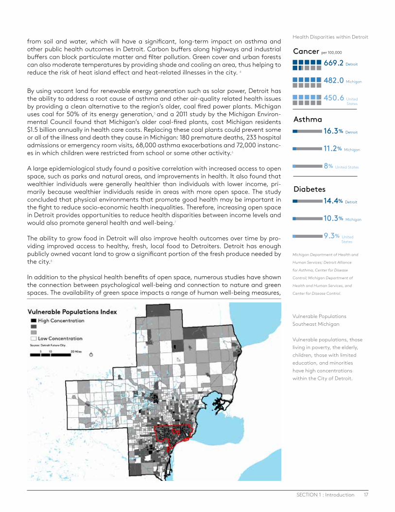
Vulnerable Populations Southeast Michigan
Vulnerable populations, those living in poverty, the elderly, children, those with limited education, and minorities have high concentrations within the City of Detroit.
Health Disparities within Detroit
Cancer per 100,000
669.2 Detroit
482.0 Michigan
450.6 United States
Asthma16.3% Detroit
11.2% Michigan
8% United States
Diabetes14.4% Detroit
10.3% Michigan
9.3% United States
Michigan Department of Health and
Human Services; Detroit Alliance
for Asthma, Center for Disease
Control; Michigan Department of
Health and Human Services, and
Center for Disease Control.

18 DETROIT FUTURE CITY - APRIL 14, 2016
including association with a positive mood, general psychological well-being, improved vitality, reduced mental fatigue, and reduced feelings of stress.8
Public open spaces can also enhance the sense of community and social fabric within the city. By providing places to gather and connect with neighbors, green spaces can increase social interaction and improve the overall sense of belonging to a place. This type of improved social fabric can reduce crime, lower levels of violence and aggression between domestic partners, and provide better capacity to cope with life’s demands, especially the stresses of living in poverty.9
Economic BenefitsTransforming vacant land into an open space amenity also has numerous economic benefits that are critical for economic recovery of Detroit.
Few activities can so profoundly and positively transform the local economy than per-manently removing vacant property from the real estate market. Such a move is in line with basic economic principles of supply and demand, addressing the current reality that the substantial disconnect between excessive supply and limited to no demand for property in Detroit suppresses property values and keeps them low. Permanently removing property from the private market decreases overall supply and will therefore help to stabilize property values.
An integrated open space plan goes beyond merely decreasing supply. It will also add value through the deliberate transformation of the city’s vacant property liability into a true open space asset. In the long term, the open space network will become an amenity that will improve the quality of life for residents and improve the attractiveness of adjacent employment districts, therefore increasing the value of those properties and demand for reinvestment. By attracting tax-paying businesses and residents to commu-nities, open space can improve the fiscal sustainability of city government.10
Permanently designating open space also allows for the opportunity to strategically realign city systems in these areas to decrease infrastructure and service costs. This reduction in cost will allow for the strategic investment in city systems in areas targeted for growth, such as employment districts, which have the potential for revenue growth
20 Year Strategic Renewal Scenario
DFC Strategic Framework, page 176
“A city’s parks system not only provides health and environmental benefits, a sense of community, and a higher quality of life, it is also good for the bottom line. Parks can significantly increase property values, attract and retain businesses, attract and retain a talented workforce, revitalize cities and communities, boost the tourism industry, create jobs, and increase tax revenues. Parks also play a major role in economic development and economic growth. In fact, numerous studies and surveys have shown that, under the umbrella of quality of life, parks have been a key component in San Francisco’s economic success.”
- Open Space San Fransisco 12
Source: Happold Consulting, Inc.
20-YEAR STRATEGIC RENEWAL SCENARIO
REPLACE, REPURPOSE, OR DECOMMISSION
REDUCE AND MAINTAIN
RENEW AND MAINTAIN
UPGRADE AND MAINTAIN

19SECTION 1 : Introduction
and significant job creation. In addition, the open space areas can be used for green stormwater infrastructure that can replace aging gray infrastructure.
The open space network can also contribute directly to economic growth, including the creation of jobs related to the green economy. With only 27 jobs per 100 residents in Detroit, the ability of the open space network to create jobs and local direct and indirect employment opportunities offers exceptional value to Detroit. Jobs can be related to productive uses such as urban agriculture, energy production, tree farms, or creation of biofuels or can relate to the design, installation, and maintenance of green infrastruc-ture.
Investments in green stormwater infrastructure have particular potential. According to the Environmental Protection Agency, the U.S. needs to invest at least $188.4 billion over the next five years just to make water systems safe and reliable. This level of investment represents an opportunity to create roughly 2 million jobs. Investments in water infra-structure would also generate an estimated $265.6 billion in economic activity. Many jobs associated with green infrastructure are accessible to traditionally under-employed and disadvantaged groups, provide decent wages, and offer career advancement op-portunities.11
The food system in Detroit also holds potential for economic growth. The food system produces significant tax revenues for the City of Detroit and the State of Michigan. It is estimated that the food system in Detroit, and the spillover impacts that result from its existence throughout the three-county region, grow various local and state tax bases such that the City of Detroit and the State of Michigan generate a combined $125 million per year in tax revenues. The largest opportunity to increase localized economic activity related to the food system is in crop production. Growing food in Detroit provides some job opportunities and there are programs set up for workforce development for farming. Even more significant job opportunities and economic growth potential exists in Detroit’s robust food processing sector, after the food is grown.13
Solar energy development provides significant opportunity to generate revenue in De-troit. With the rise of community net-metering programs, individual residents could have
In Salem, Oregon, land adjacent to a greenbelt was estimated to be worth about $1,200 an acre more than land only 1,000 feet away.
In Oakland, California, a three-mile greenbelt near the city center, was found to add $41 million to surrounding property values.
Homes bordering a 12-mile trail sold for 6 percent more than other houses of comparable size in Seattle, Washington.
Residents of Denver, Colorado surveyed in 1990 reported that they would pay more to live near a greenbelt or park.
In San Francisco, the Golden Gate Park is estimated to increase nearby property values by between $500 million and $1 billion, generating $5-$10 million in annual property taxes.
Examples of the economic benefits and impact of open space around the country.14
U.S. needs to invest at least $188.4 billion over the next five years just to make water systems safe and reliable.

20 DETROIT FUTURE CITY - APRIL 14, 2016
the opportunity to benefit economically from these developments even if they do not live adjacent to a solar development. As an industry, solar is one of the fastest growing industries in the country, adding jobs 10 times faster than the rest of the economy. This growth is projected to increase as demand for clean and renewable energy increases, with solar representing 40% of all new electric generating capacity brought online in the first half of 2015.15 This growth represents an opportunity for jobs for Detroit. As President Obama stated in his 2014 State of the Union, “every four minutes, another American home or business goes solar, every panel pounded into place by a worker whose job can’t be outsourced.” 16
In addition to the creation of jobs, putting vacant land to productive use provides the economic benefit of creating tax revenue for the City of Detroit, which provides numer-ous benefits for overall fiscal sustainability for the City.
While the economic benefits of transforming vacant land into open space are real and not insignificant, it is important to understand that this alone will not grow Detroit’s economy. This effort must be coupled with the focused, strategic employment growth in Detroit’s Employment Districts. Combined with the social benefits and environmental benefits described below, there is a clear case for open space in Detroit.
Environmental BenefitsOpen space provides numerous environmental benefits in urban areas, including improv-ing air and water quality, reducing climate impacts, and providing habitat for wildlife.
AIR QUALITY AND CLIMATE CHANGEDirect Benefits: Open space that increases tree canopy and the amount of vegetation in the city can reduce air pollution by absorbing airborne pollutants from the atmosphere. Cities have as little as 10-12% oxygen in the atmosphere compared with 20-21% in other areas, caused by both pollution and the absence of vegetation.17 Urban trees and vegeta-tion can increase or maintain levels of oxygen and reduce CO2, therefore improving local air quality. As mentioned in the public health section, buffers hold particular potential to improve air quality in Detroit as well as increasing the tree canopy overall.
Urban open space can reduce air pollutants that contribute to climate change, while also acting as carbon ‘sinks’ and help to cool the urban environment. Detroit is projected to see a dramatic increase in the number of hot days exceeding 90°F, assuming current rates of global greenhouse gas emissions increases, with projected annual heat related deaths reaching approximately 255 by 2020.18 Trees and vegetation can reduce the urban heat island effect, helping to moderate temperatures by providing shade and cooling an area through evapotranspiration.
Indirect Benefits: In addition to direct benefits to air quality and climate, open space can provide a number of indirect benefits. Researchers estimate that 5-10% of the current urban electricity demand is spent to cool buildings just to compensate for the increase in urban temperatures,19 thus planting trees in cities also has an indirect effect on CO2 by reducing the demand for energy, and thereby reducing emissions from power plants.
In addition, by providing open space in close proximity to where people live, instead of only out in rural areas, people can walk, bike, take transit, or drive short distances to access open space, reducing the number of miles traveled and reducing the associated air pollution from automobile travel. Urban agriculture provides food close to the source of demand, therefore reducing the distance food has to travel, and reducing overall carbon impact.
Opportunities to use vacant land for producing renewable energy, such as solar energy, can also have positive indirect impacts on air quality and climate change by reducing the dependence on coal fired power plants and other power sources that impact air quality, green house gases, and public health.21 Power plants are the largest source of greenhouse gas emissions in the U.S. , and by moving away from fossil fuel power plants
In a study focused on the greater Chicago region, “trees in leaf season removed an average of 1.3 tons/day of carbon monoxide (CO), 4 tons/day of sulfur dioxide (SO2), 4.6 tons/day of nitrogen dioxide (NO2), 11.9 tons/day of ozone (O3), and 9.8 tons/day of partic-ulate matter less than 10 microns (PM10).”
–McPherson, 199420

21SECTION 1 : Introduction
such as coal and natural gas, Detroit can mitigate the effects of climate change such as extreme heat waves and severe precipitation.
WATER QUALITYOpen space in urban areas can help to reduce flooding and sewer overflows by absorbing large amounts of stormwater, both replenishing the groundwater supply and preventing the need for the water to be channeled through our sewers. Storms in the midwest are increasing in severity and frequency, resulting in the increased likelihood of flood-ing and the possibility of overburdening Detroit’s combined sewer overflow system. Combined sewer overflows threaten Great Lakes water quality and can lead to harmful algae blooms, as it did in August 2014 when the water of Lake Erie was contaminated.22 Urban open space and natural areas preserve natural processes of infiltration and limit impervious surfaces, both of which are intimately linked to stormwater management and water quality.23
Green stormwater infrastructure can be incorporated throughout the open space net-work and throughout all areas of the city, which provides more natural ways to manage stormwater and improve overall water quality. Other open space types, such as natural areas like forests, wetlands, and riparian buffers, provide significant water quality bene-fits when incorporated into the open space network.
HABITATDetroit’s open space network can provide important habitat for wildlife, supporting biodiversity and providing access to wildlife and natural areas for residents. Detroit sits at a critical location along the Detroit River for fish, butterfly, raptor, neo-tropical bird, and waterfowl species migration and provides a home to numerous other species. An estimated three million ducks, geese, swans, and coots migrate annually through this region. The Michigan Department of Natural Resources and Ontario Ministry of Natural Resources recognize the Detroit River as having one of the highest diversities of wildlife and fish in all of the Great Lakes. More than 29 species of waterfowl and 65 kinds of fish make their home in the Detroit River. The Detroit Audubon Society has documented over 300 species of birds in the Detroit-Windsor area and approximately 150 bird species nest near the river.24 Detroit is an important location for providing wildlife habitat that simply cannot be provided in other areas outside of the city.
Vacant land in Detroit can be restored as a habitat for native species.
Photo Credit: Andrew Potter for DFC
22 DETROIT FUTURE CITY - APRIL 14, 2016
Transforming vacant land into an open space amenity has numerous social, economic, and environmental benefits that will improve quality of life for all Detroiters. But in order to achieve an integrated open space network, an open space plan is needed to establish and balance shared values, prioritize different types of open space in specific areas of the city, and to engage residents and stakeholders in the process.
OPEN SPACE PLANNINGAn integrated open space plan will allow Detroit to realize the vision of creating an open space network, and to serve as a catalyst that provides environmental, economic, and social benefits to all Detroiters. An integrated open space network will not just happen on its own – a plan is needed to set policies, guide decision-making, and prioritize imple-mentation strategies. Without a plan, City staff, developers, foundations, community organizations, federal and state agencies, and the general public will not be able to make informed decisions about where to invest in traditional development versus where to invest in open space. Designating areas for open space will ensure critical components of the network are preserved.
A city-wide open space plan will lay out where different types of open space are appro-priate and desired and how they connect into a cohesive network. It will balance the dif-ferent types of open space based on the needs and desires of community members, the ecological function, and economic opportunity. It will connect open space through high vacancy areas, through neighborhoods, and through high density employment districts – improving quality of life for all Detroiters. In order to make this happen, all stakeholders need to be engaged through a city-wide open space planning process to ensure we are all working to achieve a shared vision.
At a city-wide level, an open space plan should identify and protect those critical natural areas that cannot be relocated, such as wetlands, streams, rivers, and floodplains. Key connections between open spaces, such as greenways and buffers, should be identified and protected to ensure a contiguous network is created. These city-wide assets can then be incorporated into community level plans, where communities can have even greater say in the type and location of open space.
· Create a food sovereign city by growing the food we need in the city
· Use 100% renewable energy in the city
· Clean the air we breathe and improve our health by planting trees and other plants to clean the air, reducing asthma and other health impacts
· Clean our water by reducing pollution that enters our rivers and lakes
· Provide habitat for animals, insects, and plants to ensure biodiversity
· Provide places to bike, walk, run, play, and recreate
· Create a beautiful place to live and visit
· Generate jobs and economic opportunities through the green economy
· Reduce the supply of underutilized, vacant, blighted land that impacts property values and quality of life
· Stabilize neighborhoods through blight removal
· Connect neighborhoods and employment districts with greenways and trails
Values
The people of Detroit need to consider, evaluate, and refine these values around transforming the city’s vacant land into an innovative open space network to help prioritize the goals, policies, and actions of an open space plan.
An integrated open space network will not just happen on its own – a plan is needed, to balance shared values and prioritize different types of open space through the engagement residents and stakeholders.

23SECTION 1 : Introduction
A planning process will establish a vision for open space in the city as well as establish goals and objectives for the whole network. The planning process will create a deci-sion-making framework for how to achieve the vision for open space by ensuring that all decisions about vacant land transformation are made deliberately so that the different types of open space and the amount of permanent open space is achieving the vision. For example, planting all vacant land with trees would have numerous public health and environmental benefits, but could prevent the city from achieving food security or energy independence. It is critical to have a balance of open space types that work to achieve social, environmental, and economic benefits for all Detroiters.
Participatory ModelingPlanning for open space at the citywide and neighborhood scales is important to un-derstand how different types of open space can be implemented across the city. This planning process also needs to address how all of these different open space types fit together, what the benefits of each use are, and what objectives they are working to achieve. Participatory modeling can be used to show the expected outcomes from vary-ing amounts of each type of use as they are deployed within the city in varying amounts. This method includes community stakeholders in the modeling process and uses infor-mation about their goals for the community to show a range of possible future scenarios and how they can affect the community as they are implemented. This has the opportu-nity to advance the conversation in the city around the reuse of vacant land, and show how different scales of each reuse could impact the city and how that relates to the values of the community. Participatory modeling will enable participants in the planning process to determine an appropriate balance of how vacant land should be reused to create an open space network that achieves the overall values of the community.
Framework for PlanningPlanning for open space can be integrated into the City’s Master Plan of Policies plan-ning process or could be its own planning process, which could be integrated into the Master Plan through a supplement. Either way, it is critical to establish a city-wide vision for open space that shows how open space connects through areas of growth, areas of stabilization and areas of transformation. This city-wide vision, with clear policies for decision-making, should also enable and empower communities to refine open space at the community level. The plan should provide details about the different types of open space and where they are appropriate or inappropriate. It should provide policies to inform decision-making and clear implementation strategies (with time frames, funding mechanisms, and responsible parties) to ensure the open space network is achieved over time. The recommendations in this report are intended to inform this planning process, by providing considerations for decision-making, both at the city-wide level and the community level.
Key recommendations for the planning process and the plan include:
· Ensure a robust community engagement process
· Utilize a participatory systems modeling approach to balance the goals and objectives of open space
· Identify environmentally critical areas that need to be protected at a city-wide scale
· Identify and protect critical connections between open space areas
· Identify areas that need to be designated as specific type of open space versus areas that can be flexible and can be designated at the community level
· Create a process for community plans to be integrated into the city-wide open space plan
· Provide certainty for developers, investors, green entrepreneurs, farmers, and community members
“There must be neighborhood level open space plans that focus on the value and benefits of open space to individual neighborhoods”
- Mark Wyckoff, Sr. Associate Director, MSU Land Policy Institute
Participatory modeling addresses how different open space types fit together, what the benefits of each use are, and what objectives they are working to achieve.

Background2
Photo Credit: Andrew Potter
25
BACKGROUND2
SECTION 2 : Background
CURRENT CONDITIONSDetroit is currently faced with a vast amount of vacant land and buildings that are the result of fifty years of disinvestment and abandonment. This is not a new issue for the city and in recent years has been well documented. By the early 1980’s it was estimated that there were 55,000 vacant lots, which composed an area roughly equal to 15 square miles.25 Through the 1980’s, 1990’s and 2000’s this number continued to increase with continued disinvestment, abandonment and demolition. By 2010 it was estimated that 20 square miles of the city was vacant.26 With the completion of the Motor City Mapping project in 2014, which was intended to capture the full extent of blight and abandon-ment within the city of Detroit, it was found that there were more than 113,000 vacant parcels that account for 22.6 square miles of the city.27
The amount of vacant land currently within Detroit is staggering and this number con-tinues to grow. The Blight Removal Task Force found that there were more than 40,00029
parcels with a structure that could be considered blighted. While there are many inter-ventions to remediate these blighted structures, demolition has been a primary blight remediation strategy for the City of Detroit. Over the past two years, the City has ramped up an already aggressive demolition campaign, removing approximately 6,000 structures28 using available funding through the Hardest Hit Fund, fire escrow, and other programs.
With a struggling housing market in many neighborhoods within the city, the removal of these blighted structures will remain a prominent tactic for reducing blight to improve the physical and market conditions within Detroit neighborhoods. As more and more blighted structures are removed, however, the number of vacant lots within the city will continue to grow. Many factors will determine the extent to which the city will continue to use demolition or deconstruction as a tactic to remediate blight, but the continued removal of structures could result in more than 155,000 parcels without a structure, which is approximately 30 square miles.
The scale of vacant land in Detroit creates unique opportunities for reutilization, but the nature of vacant land and where it is located within the city can be a hindrance to the reuse of this land. As it currently stands, the vast majority of the vacant land within the city is small, formerly residential parcels. Even when these parcels are combined to cre-ate larger contiguous parcels, 97% of those parcels are smaller than 1 acre. Even as the city continues to demolish structures and add additional vacant lots to the inventory, only a small fraction of these properties are of substantial size, and of the properties that are greater than 5 acres, only 71 are located in areas that would be appropriate for larger scale open space uses.
While the scale of vacant land in the city is immense, only a small percentage of this is likely to be used for conventional redevelopment, such as new housing or commercial or industrial development. The majority of this vacant land is in areas of the city where it is unlikely to see redevelopment pressure in the near or medium term. These sites range from small single parcels within a relatively stable neighborhood to larger sites in areas where the predominant land use is vacancy. Currently more than 60% of Detroit’s vacant land is located in areas of the city where reuse as open space is the most appropriate.
The vast majority of the vacant land within the city is small, formerly residential parcels; 97% of these are smaller than one acre.
Inside this Section
25 Current Conditions
28 Existing Plans, Policies and Organizations
30 Detroit Future City Relevant Work
26 DETROIT FUTURE CITY - APRIL 14, 2016
In addition, even in the Traditional Residential Areas, less than half of vacant parcels are located next to an occupied house and would have the potential to become a sidelot.24
The percentage of potential sidelots is much smaller in transformation areas.
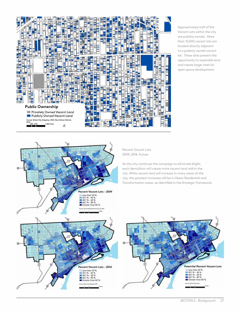
A critical aspect in transforming vacant land into open space is ownership. Often the easiest path to reuse is through the inventory of publicly owned land, but only 50% of vacant parcels are in public ownership. When the inventory of vacant land is examined for ownership by public entities such as the City of Detroit or the Detroit Land Bank Authority, the amount of large sites available for any range of reuse options declines dramatically. In addition to the decline in the total number of sites, the size and scale of these sites also declines. Of the total sites that are under public control 95% are less than .5 acres and 61% are composed of a single parcel. In Detroit, the average residential parcel is approximately 4,700 square feet.
The relatively small size of vacant publicly owned parcels can be a hindrance to the large-scale reuse of vacant land within Detroit, but these individual parcels can become part of the larger open space network, with clear policies and strategies to incorporate them into the larger reuse strategy. This includes targeted public acquisition strategies to get more contiguous vacant land in common ownership. More than 15,000 vacant parcels throughout the city are directly adjacent to a publicly owned vacant parcel. These par-cels present the opportunity for strategic acquisition by the Detroit Land Bank Authority in order to create larger sites and better facilitate the reuse of vacant land.
The DLBA has the opportunity to leverage the ownership and control of many parcels to better facilitate the productive reuse of these parcels. This should not only include the reuse of land for conventional redevelopment within growth areas but also for open space developments within areas of transformation. Chapter 5 of this report and the CCP Open Space in Detroit report provide more details on some of these ownership strategies to ensure implementation of the open space network over time.
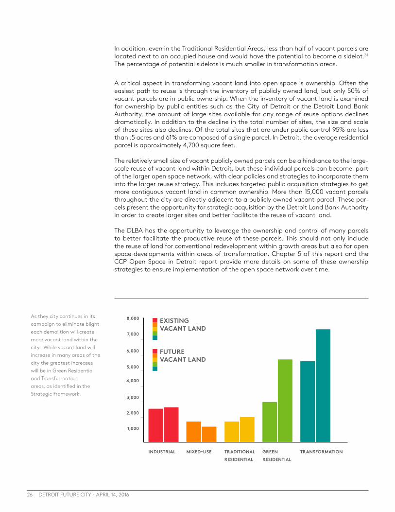
As they city continues in its campaign to eliminate blight each demolition will create more vacant land within the city. While vacant land will increase in many areas of the city the greatest increases will be in Green Residential and Transformation areas, as identified in the Strategic Framework.
1,000
2,000
3,000
4,000
5,000
6,000
7,000
8,000
INDUSTRIAL MIXED-USE TRADITIONAL RESIDENTIAL
TRANSFORMATION
FUTURE VACANT LAND
EXISTING VACANT LAND
GREEN RESIDENTIAL
27SECTION 2 : Background
Percent Vacant Lots2009, 2014, Future As the city continues the campaign to eliminate blight, each demolition will create more vacant land within the city. While vacant land will increase in many areas of the city, the greatest increases will be in Green Residential and Transformation areas, as identified in the Strategic Framework.
Approximately half of the Vacant Lots within the city are publicly owned. More than 15,000 vacant lots are located directly adjacent to a publicly owned vacant lot. These sites present the opportunity to assemble land and create larger sites for open space development.
28 DETROIT FUTURE CITY - APRIL 14, 2016
EXISTING PLANS, POLICIES, AND ORGANIZATIONSIndividuals and organizations throughout Detroit have long understood the benefits of transforming vacant land into open space. Whether it has been through maintaining the vacant lot next door, creating community gardens, creating community gathering places, growing food, or planting trees and flowers, vacant land reutilization has been occuring in communities throughout Detroit for years. In recent years, these efforts have started to make it into policies, plans, and strategies, but more work needs to be done. There are numerous existing plans and policies that relate to open space in Detroit, but a comprehensive, city-wide open space plan that addresses all types of potential open space does not exist. Each of the existing plans or policies can help to inform a larger planning process, but a city-wide open space planning process is needed to connect all the different elements and opportunities of open space in Detroit. Below are some of the relevant plans.
City of Detroit Master Plan of Policies The City’s current Master Plan of Policies generally focuses on parks and recreation facilities. The Future General Land Use Map designates Regional Parks and Recreation facilities, but does not have a land use designation for other types of open space. The city-wide policies include general policies related to parks and recreation, with only one goal related to reusing vacant land for urban agriculture. In order to achieve the poten-tial of transforming vacant land into an open space network, a land use designation for open space areas is needed and additional goals and policies related to the open space network are needed to ensure implementation over time.
City of Detroit Parks and Recreation Strategic Master PlanThis plan would be an important component of the larger open space plan, but it only provides policies and strategies related to the City of Detroit’s park and recreation facil-ities. The plan generally does not address other open space uses or recreation facilities that are not owned or maintained by the City of Detroit. This plan is in the process of being updated.
City of Detroit Zoning Ordinance The Zoning Ordinance regulates the use of land within the city of Detroit. The regulations within this section of the city code are mainly focused on conventional development and are limited in how it addresses open space. Under current Zoning Ordinance, many open space uses are not directly addressed. Amending zoning to provide for open space uses can streamline the implementation process for larger scale uses and provide long term certainty and direction to those implementing open space.
Non-Motorized PlansCITY OF DETROIT NON-MOTORIZED URBAN TRANSPORTATION MASTER PLANAdopted in June 2006, this plan set the framework for the City of Detroit to begin install-ing bike lanes and greenways throughout the city.
GREENWAY PLANNING 30
Numerous greenway planning efforts have resulted in the implementation of greenways throughout the city, including: · Conner Creek Greenway Master Plan · Detroit Riverfront Conservancy’s Riverwalk Plans · Dequindre Cut · Midtown Loop · Detroit Greenway Network Vision · Southwest Detroit Greenlink · A Vision of Greenways For the Greater Riverfront East District of Detroit. · Inner Circle Greenway

29SECTION 2 : Background
Green Infrastructure PlansSEMCOG’S GREEN INFRASTRUCTURE VISION FOR SOUTHEAST MICHIGANThis is a framework that guides preservation and future implementation of green infra-structure in Southeast Michigan. The vision benchmarks the amount of green infrastruc-ture in the region, visions future green infrastructure opportunities, and recommends strategic implementation approaches. The vision details the various benefits of green infrastructure, including economic value, water quality, air quality, and recreation. This plan sets a regional framework, but more details are needed for a complete open space vision in Detroit.31
DETROIT WATER AND SEWERAGE DEPARTMENT GREEN INFRASTRUCTURE PLANThe Green Infrastructure Plan is DWSD’s road map for implementing green infrastructure in the future for 17 specific outfalls along the Rouge River. This plan is not a comprehen-sive plan for the entire city. 32
Urban Agriculture and Food Systems Planning and PolicyNumerous studies, reports, and policies exist related to food systems and urban agricul-ture in Detroit that can help inform the urban agriculture elements of a city-wide open space plan.
A few of these reports and plans include: · A City of Detroit Policy on Food Security “Creating a Food Secure Detroit”33
· The Detroit Food System Report34
· Economic Analysis of Detroit’s Food System35
· City of Detroit Urban Agriculture Ordinance
Examples of existing open space plans, policies and organizations.
Green Infrastructure Vision for Southeast Michigan
. . . Shaping the future of Southeast MichiganSoutheast Michigan Council of Governments
Food System Report2009-2010
Prepared by Kami Pothukuchi, Ph.D., Wayne State UniversityFor the Detroit Food Policy Council
May 15, 2011
DetroitThe
30 DETROIT FUTURE CITY - APRIL 14, 2016
Community PlansA number of communities in Detroit have embraced the idea of transforming vacant land into an open space amenity and have incorporated this vision into the commu-nity plans. Using the Community Development Advocates of Detroit (CDAD) Strategic Framework, these communities have designated areas of their community for open space in categories like ‘Naturescape’, ‘Green Venture’, or ‘Urban Homestead’. The Lower Eastside Action Plan (LEAP) and ‘Restore the Moor’ are examples of these plans.
Existing OrganizationsIn addition to existing plans and policies related to different types of open space, there are also numerous organizations that focus on specific types of open space, but no organizations that focus on the full open space network. Many of these organizations provided input for this report. An open space plan could help unite all of the groups and organizations working on different types of open space to begin working towards achieving a common vision of an innovative open space network in Detroit.
DETROIT FUTURE CITY RELEVANT WORKBuilding off the recommendations in the Detroit Future City Strategic Framework, the DFC Implementation Office continues further the vision of transforming Detroit’s vacant land into an open space network. Below is a summary of DFC’s work related to open space.
CITY OF DETROIT MASTER PLAN OF POLICIES DFC made recommendations to the City of Detroit for open space land use categories and policies to be incorporated into the Master Plan of Policies in order to achieve an innovative open space network.
OPEN SPACE POLICY AND LEGAL RESEARCHDFC convened a group of legal and land use experts to make recommendations to the City of Detroit on how to implement an open space network in Detroit while reducing legal risk to the City.
CENTER FOR COMMUNITY PROGRESS REPORT: OPEN SPACE IN DETROIT: KEY OWNERSHIP AND FUNDING CONSIDERATIONS TO INFORM A COMPREHENSIVE OPEN SPACE PLANNING PROCESS DFC commissioned this report to examine the range of ownership models for open space and the funding needs and opportunities for different types of open space. The results of this research are referenced throughout this report and are summarized at the end of the report.
THE FIELD GUIDE TO WORKING WITH LOTSDFC developed a printed Field Guide to Working with Lots and robust website to provide technical resources to those interested in innovative land reutilization and neighborhood stabilization at the scale of the individual lot. This user friendly resource for residents, small groups and organizations describes a series of lot designs through step by step instructions, showcasing local best practices, and providing an action-oriented resource for a range of users. This lot by lot transformation will be an important part of the overall open space network, but it will not address areas of higher vacancy.
US DEPARTMENT OF ENERGY COORDINATIONDFC continues to coordinate with various partners to cultivate a range of renewable en-ergy and energy storage opportunities within Detroit, including Megawatt Photovoltaic, Focus: HOPE, and the Michigan National Guard.
31SECTION 2 : Background
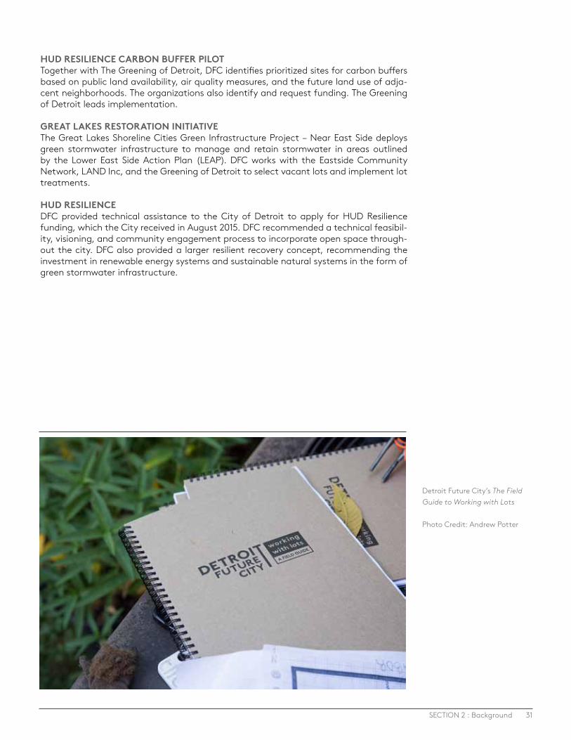
HUD RESILIENCE CARBON BUFFER PILOTTogether with The Greening of Detroit, DFC identifies prioritized sites for carbon buffers based on public land availability, air quality measures, and the future land use of adja-cent neighborhoods. The organizations also identify and request funding. The Greening of Detroit leads implementation.
GREAT LAKES RESTORATION INITIATIVE The Great Lakes Shoreline Cities Green Infrastructure Project – Near East Side deploys green stormwater infrastructure to manage and retain stormwater in areas outlined by the Lower East Side Action Plan (LEAP). DFC works with the Eastside Community Network, LAND Inc, and the Greening of Detroit to select vacant lots and implement lot treatments.
HUD RESILIENCE DFC provided technical assistance to the City of Detroit to apply for HUD Resilience funding, which the City received in August 2015. DFC recommended a technical feasibil-ity, visioning, and community engagement process to incorporate open space through-out the city. DFC also provided a larger resilient recovery concept, recommending the investment in renewable energy systems and sustainable natural systems in the form of green stormwater infrastructure.
Detroit Future City’s The Field Guide to Working with Lots
Photo Credit: Andrew Potter
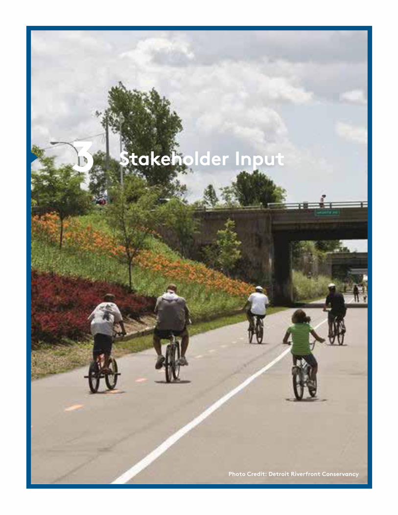
Stakeholder Input3
Photo Credit: Detroit Riverfront Conservancy

33
STAKEHOLDER INPUT3
SECTION 3 : Stakeholder Input
Over 30 stakeholders were interviewed or surveyed in order to get their feedback on open space in Detroit. The stakeholders were chosen based on their individual or orga-nizational involvement in vacant land transformation in Detroit. While the number of stakeholders involved were low, this approach was not intended to be comprehensive or to be a full engagement process, but instead it was intended to spur thoughts and ideas to help shape a robust open space planning process and to highlight some of the key opportunities and challenges facing implementation of an open space network in Detroit. The stakeholder feedback helped to shape this report and will continue to shape DFC’s work moving forward. Below is a summary of the key themes from the stakeholder feedback.
Key ThemesOpen space is the thing that could make us stand out from cities of our size in the world – it is THE opportunity for Detroit. This unique opportunity to transform vacant land into an open space network includes: · Using vacant land as part of a new infrastructure system, especially for stormwater
management · Improving quality of life for Detroiters · Connecting open spaces and the whole city with greenways and buffers
Detroit needs a plan for how to achieve the open space network, including clear policies and regulations to ensure implementation over time. The plan needs to: · Designate open space in the Master Plan of Policies, a city-wide open space plan, and
integration into the Zoning Ordinance, with some flexibility to create neighborhood level decisions about types of open space.
· Permanently protect critical portions of the open space network
· Ensure nature, food systems, and health are incorporated
· Ensure the open space network connects throughout the city
· Provide guidelines for different types of open space, including location considerations and the amount of land that should be set aside for different types of open space.
· Allow the community to shape the plan through robust community engagement and ensure the plan addresses the concerns of people in Detroit.
There are some key barriers and issues that are preventing the creation of an open space network, including the need for: · Transparent and streamlined policies and procedures for site control and access to land.
People want to know how to get access to land, either lease or purchase, and how these decisions are made. In order for people to invest in land, they need certainty around site control
· Policies and standards to ensure quality of demolition and post demolition in order to set the community up for success for transforming vacant lot.
· Resources, including money, to make sure the open space network is achieved. Communities need resources to be stewards of land, but also larger agencies and organizations need resources to manage land at a larger scale.
The following key themes emerged from the surveys and discussion.
Inside this Section
33 Stakeholder Input
Potential Open Space Types4
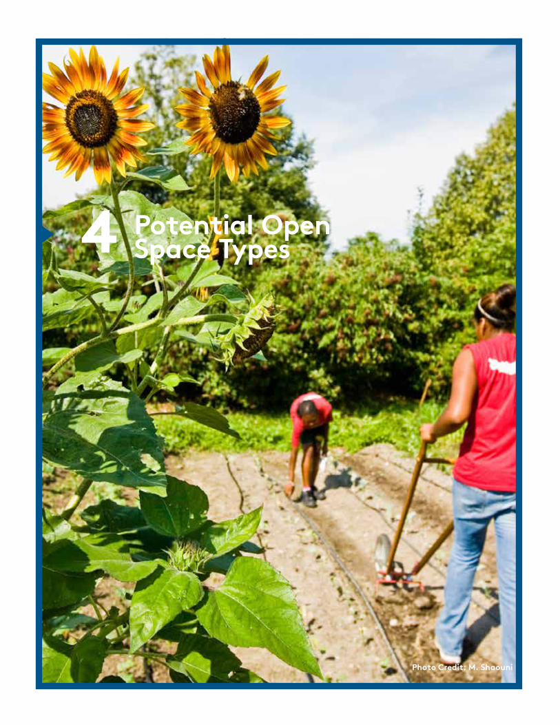
Photo Credit: M. Shaouni
35
POTENTIAL OPEN SPACE TYPES4
SECTION 4 : Potential Open Space Types
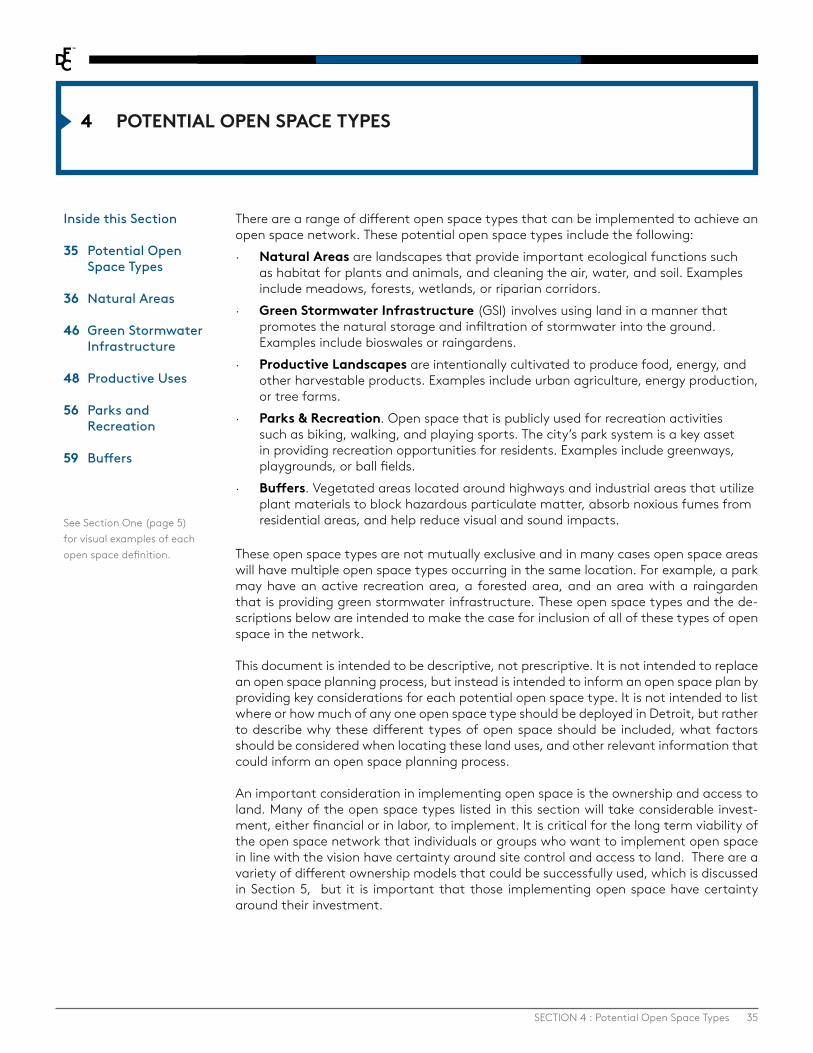
There are a range of different open space types that can be implemented to achieve an open space network. These potential open space types include the following: · Natural Areas are landscapes that provide important ecological functions such
as habitat for plants and animals, and cleaning the air, water, and soil. Examples include meadows, forests, wetlands, or riparian corridors.
· Green Stormwater Infrastructure (GSI) involves using land in a manner that promotes the natural storage and infiltration of stormwater into the ground. Examples include bioswales or raingardens.
· Productive Landscapes are intentionally cultivated to produce food, energy, and other harvestable products. Examples include urban agriculture, energy production, or tree farms.
· Parks & Recreation. Open space that is publicly used for recreation activities such as biking, walking, and playing sports. The city’s park system is a key asset in providing recreation opportunities for residents. Examples include greenways, playgrounds, or ball fields.
· Buffers. Vegetated areas located around highways and industrial areas that utilize plant materials to block hazardous particulate matter, absorb noxious fumes from residential areas, and help reduce visual and sound impacts.
These open space types are not mutually exclusive and in many cases open space areas will have multiple open space types occurring in the same location. For example, a park may have an active recreation area, a forested area, and an area with a raingarden that is providing green stormwater infrastructure. These open space types and the de-scriptions below are intended to make the case for inclusion of all of these types of open space in the network.
This document is intended to be descriptive, not prescriptive. It is not intended to replace an open space planning process, but instead is intended to inform an open space plan by providing key considerations for each potential open space type. It is not intended to list where or how much of any one open space type should be deployed in Detroit, but rather to describe why these different types of open space should be included, what factors should be considered when locating these land uses, and other relevant information that could inform an open space planning process.
An important consideration in implementing open space is the ownership and access to land. Many of the open space types listed in this section will take considerable invest-ment, either financial or in labor, to implement. It is critical for the long term viability of the open space network that individuals or groups who want to implement open space in line with the vision have certainty around site control and access to land. There are a variety of different ownership models that could be successfully used, which is discussed in Section 5, but it is important that those implementing open space have certainty around their investment.
See Section One (page 5) for visual examples of each open space definition.
Inside this Section
35 Potential Open Space Types
36 Natural Areas
46 Green Stormwater Infrastructure
48 Productive Uses 56 Parks and Recreation
59 Buffers
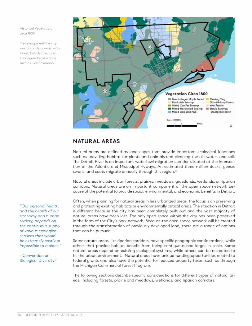
36 DETROIT FUTURE CITY - APRIL 14, 2016
NATURAL AREASNatural areas are defined as landscapes that provide important ecological functions such as providing habitat for plants and animals and cleaning the air, water, and soil. The Detroit River is an important waterfowl migration corridor situated at the intersec-tion of the Atlantic and Mississippi Flyways. An estimated three million ducks, geese, swans, and coots migrate annually through this region.36
Natural areas include urban forests, prairies, meadows, grasslands, wetlands, or riparian corridors. Natural areas are an important component of the open space network be-cause of the potential to provide social, environmental, and economic benefits in Detroit.
Often, when planning for natural areas in less urbanized areas, the focus is on preserving and protecting existing habitats or environmentally critical areas. The situation in Detroit is different because the city has been completely built out and the vast majority of natural areas have been lost. The only open space within the city has been preserved in the form of the City’s park network. Because the open space network will be created through the transformation of previously developed land, there are a range of options that can be pursued.
Some natural areas, like riparian corridors, have specific geographic considerations, while others that provide habitat benefit from being contiguous and larger in scale. Some natural areas depend on existing ecological systems, while others can be recreated to fit the urban environment. Natural areas have unique funding opportunities related to federal grants and also have the potential for reduced property taxes, such as through the Michigan Commercial Forest Program.
The following sections describe specific considerations for different types of natural ar-eas, including forests, prairie and meadows, wetlands, and riparian corridors.
“Our personal health, and the health of our economy and human society, depends on the continuous supply of various ecological services that would be extremely costly or impossible to replace.”
- Convention on Biological Diversity37
Historical Vegetation, circa 1800
Predevelopment the city was primarily covered with forest, but also featured endangered ecosystems such as Oak Savannah.

37SECTION 4 : Potential Open Space Types
Natural Areas: ForestsThe creation and expansion of the forests and other wooded natural areas within the city is an opportunity that can create many positive outcomes for the city. Trees have been shown to provide many benefits both to the environment and to the health of populations that reside in proximity to them. The city’s existing tree canopy, at just over 16%, falls below many tree canopy recommendations.38 American Forests recommends 40% tree canopy for a region, but this has been broken down to better fit into urban conditions. These recommendations vary from 50% in suburban areas, to 25% in urban neighborhoods, which make up much of Detroit’s land area, and 15% in the urban core areas such as Downtown and Midtown. Based on these recommendations, a 30% tree canopy is recommended for Detroit. This would double the number of trees in Detroit, requiring over 1 million additional trees to be planted.
Overall, the urban forest consists of a variety of trees from street trees and trees in resi-dents yards to larger natural areas found in city parks and open space areas. Increasing the city’s tree canopy will take more than just planting street trees. Trees will need to be incorporated into open space areas in the form of urban forests, woodlands, and treed buffers. There are several assets that the city can build off of, including existing parks like Rouge Park or Belle Isle, which have significant tree canopy cover and naturalized forests.
There are also small treed areas, or ‘forest patches’ that exist throughout the city, pri-marily in residential areas along property lines. These small forest patches are areas of tree cover greater than 10,000 square feet.39 While these areas remain relatively small, with intentional care and strategies to expand onto adjacent vacant land, these patches of forest have the potential to provide additional benefits to the city, including added environmental benefits from understory and habitat. Baltimore Greenspace has done significant research on the potential of forest patches and even provides a tool for citi-zens on how to take care of forest patches.
Currently, Detroit is covered by a 16% tree canopy. To increase this to 30% will require more than 1 million trees.
Baltimore Greenspace has done significant work related to forest patches and even has a citizen guide for caring for neighborhood forest patches:ForestPatch_Spreads.pdf
CREATED BY KATIE LAUTAR
Existing Tree Canopy in Detroit
While the City of Detroit has a tree canopy of 16 % it is not evenly distributed across the city. There are locations where the City should look to strategically increase canopy.

38 DETROIT FUTURE CITY - APRIL 14, 2016
Providing larger, contiguous areas in the city for urban forests can provide greater eco-system services, improved habitat for wildlife, and recreational opportunities for Detroit residents. The ecosystem services include air quality improvements and increased storm-water capture. In addition, contiguous forested areas provide increased biodiversity and provide a range of habitat for wildlife that are not found in street or backyard trees. This can lead to an increase in species that are not found elsewhere in the city. These forested areas can also provide unique recreational opportunities including hiking, biking, or bird watching that otherwise would not be accessible to many Detroit residents.
The public health benefits that an increased tree canopy will provide is particularly im-portant to vulnerable populations that reside within the city. While the amount of tree canopy needs to be increased all across the city, this transformation will take time. The Healthier, Greener Detroit Working Group, convened by the Greening of Detroit devel-oped a method to identify areas of the city that should be prioritized for tree planting based on location of the most vulnerable populations, where health impacts are great-est, and where tree canopy is the smallest.
CONSIDERATIONS FOR FORESTS: · Expand tree planting programs to increase the overall tree canopy within the city. · Prioritize tree plantings in areas with high concentrations of vulnerable
populations. · Expand and improve existing forest patches throughout the city. · Incorporate passive recreational opportunities when creating forested areas. · Consider the creation of larger scale, contiguous forested areas, which provide
greater ecological benefits and are better suited for habitat.
The Healthier Greener Detroit Working Group worked to identify places within the city to prioritize the planting of trees based on their ability to mitigate conditions such as the Urban Heat Island Effect and improve air quality which can contribute to Asthma.

39
Saginaw Forest is a nearly 80-acre parcel of land comprised of roughly 55 acres of forested area, Third Sister Lake, and surrounding wetlands. The property, a gift to the University of Michigan in 1903, is used for forestry operations, research and instruction by the School of Natural Resources and Environment. The forest is located in the City of Ann Arbor, just 3 miles from the University of Michigan on West Liberty Road. It is open to the public for recreational purposes.
Saginaw Forest is an example of how forests can be incorporated into the urban environment, providing significant ecological benefits, environmental health benefits, and recreational opportunities.
Photo Credit: University of Michigan
SECTION 4 : Potential Open Space Types
CASE STUDY: SAGINAW FOREST, ANN ARBOR, MI

40 DETROIT FUTURE CITY - APRIL 14, 2016
Natural Areas: Prairies and MeadowsOne of the natural area options for the open space network is the creation of meadows or prairies. While these would be new to the city in 2015, the city was originally covered with several types of these ecosystems, including oak savanna and wet prairie. These ecosystems were once common in the area but over time they have become increasingly rare. The loss of these ecosystems has resulted in a decline in the populations of grass-land birds that call prairies home.40
Meadows and prairies also have positive effects on stormwater. The grasses typical of a prairie or meadow provide increased stormwater benefits over the grasses that are currently growing on Detroit’s vacant land. This is due to the depth of the root system, which encourages infiltration.41 This can be a cost effective method to increasing the stormwater performance of Detroit’s vacant land and it can have stormwater benefits at the individual lot scale up to larger scale interventions. In addition to stormwater benefits, the introduction of meadows and prairies into the city can provide habitat for a range of bird species, including some rare and endangered species. When creating meadows or prairies for habitat, however, scale is important. Small dispersed plantings may not have positive impacts from a habitat perspective for all types of birds. As is generally true for the creation of habitat, the larger and more con-tiguous the area, the better suited it is to provide habitat. Some types of wildlife, such as pheasants, which already call Detroit’s vacant land home, scale may be less important.
One advantage to the creation of meadows and prairie ecosystems is that they are relatively inexpensive to create and maintain. Costing approximately $3,000 to $4,000 per acre to install, this is much less than other natural areas such as a forest which could cost $4,000 to $10,000 per acre to install. The maintenance for meadows and prairies is also modest,potentially only costing a few hundred dollars per year, depending on the amount of mowing that is desirable.
CONSIDERATIONS FOR PRAIRIES & MEADOWS · Consider larger more contiguous areas for meadows and prairies as they have greater
potential to provide habitat for many species of grassland birds.
· Consider land ownership and maintenance models that allow for the preservations of permanent open space.
· Prioritize creating habitat for rare and endangered species.
· Incorporate the creation of meadows and prairies into Detroit’s larger green stormwater infrastructure strategy

41SECTION 4 : Potential Open Space Types
CASE STUDY: OJIBWAY PRAIRIE COMPLEX, WINDSOR, ONTARIO
The Ojibway Prairie complex is a series of five natural areas totaling 604 acres located within the city limits of Windsor, Ontario. The Ojibway Prairie preserves several rare ecosystems, such as the tall grass prairie and Oak Savannah. These ecosystems were once common in Southwest Ontario but have become increasingly rare and currently make up less than .5% of SW Ontario’s prairies. The Prairie Complex is home to a large variety of plants and animals, including more than 160 provincially rare plant and animal species, such as the Eastern Massasauga Rattlesnake and the Little Brown Bat.
The site has been preserved through the purchase of land by the City of Windsor and the Province of Ontario. These purchases were made with the intent of preserving some of the last remaining examples of these endangered ecosystems. One of the most striking features of the Ojibway Prairie Complex is its location. Located just 5 miles from Downtown Windsor, the Ojibway Prairie Complex provides easy access for Windsor residents to a high quality natural experience. The Prairie Complex is accessible by bus and school children can walk to it from nearby schools.

42 DETROIT FUTURE CITY - APRIL 14, 2016
Natural Areas: WetlandsFor regulatory purposes under the Clean Water Act, the term wetlands means “those areas that are inundated or saturated by surface or groundwater at a frequency and duration sufficient to support, and that under normal circumstances do support, a prevalence of vegetation typically adapted for life in saturated soil conditions. Wetlands generally include swamps, marshes, bogs and similar areas.” 42
Wetlands can be a component of many of the other types of open space outlined in this report, including riparian corridors, forests, or green stormwater infrastructure, but they have unique characteristics that provide significant contributions to water quality and habitat, so it is important to include wetlands as a unique category.
Wetlands are an important source of biodiversity, supporting approximately 20% of all living organisms.43 Wetlands also provide important ecosystem services including help-ing to manage stormwater, retaining and filtering nutrients and pollutants, mitigating floods, modifying micro climates, and sequestering carbon.44
Great Lakes coastal wetlands are some of the most biologically diverse ecosystems in Michigan and they are crucial to the health of the Great Lakes basin as a whole. Coastal wetlands serve as spawning and nesting habitat for a variety of animals, help maintain water quality throughout the basin, aid in preventing erosion along exposed shorelines and offer recreational and tourism opportunities throughout the state.45
Over 95% of the historical coastal wetlands along the Detroit River have been lost to de-velopment.46 A majority of wetlands have been lost throughout Detroit, including along the Rouge River and in other areas that previously had been swamp. In most cases, the opportunity to preserve existing or restore degraded wetlands no longer exists because they have already been destroyed and developed. The opportunity for Detroit today is
Milliken State Park Wetland
Photo Credit: Detroit Riverfront Conservancy
Wetlands can be a component of many of the other types of open space, but they have unique characteristics of their own
43SECTION 4 : Potential Open Space Types
· Reduce flooding by absorbing runoff from rain and melting snow and slowly releasing excess water into rivers and lakes - a one acre swamp when flooded to a depth of one foot contains 330,000 gallons of water
· Filter pollutants from surface runoff, trapping fertilizers, pesticides, sediments, and other contaminants and helping to break some of them down into less harmful substances, improving water clarity and quality
· Help recharge groundwater supplies when connected to underground aquifers
· Contribute to natural nutrient and water
cycles, and produce vital atmospheric gases, including oxygen
· Provide commercial or recreational value to our human economy, by producing plants, game birds (ducks, geese) and fur bearing mammals - many fish are directly connected to wetlands, requiring shallow water areas for breeding, feeding and escaping from predators
· When wetlands occur adjacent to the Great Lakes, inland lakes or streams, they serve as nutrient traps that then enrich the larger body of water of which they are part
Wetlands
Wetlands serve the environment in many different ways. SEMCOG GI Vision
to preserve and protect the few wetlands that do exist and create new wetlands as the open space network is created and as the city redevelops. Wetlands can be incorporated into parks and other natural areas. Wetlands should be incorporated as part of Detroit’s larger stormwater management program, adding more ecosystem functions than other green stormwater infrastructure methods. Priority for wetlands should be in riparian corridors along the Detroit River and Rouge River.
CONSIDERATIONS FOR WETLANDS
· Preserve and protect existing wetlands in Detroit · Restore wetlands where feasible · Create new wetlands as part of the open space network and as part of new
development · Prioritize the creation and restoration of wetlands in riparian corridors on the
Rouge River and Detroit River, increasing the amount of Great Lakes coastal wetlands.
· Incorporate wetlands as an important part of the larger stormwater management strategy for Detroit.

44 DETROIT FUTURE CITY - APRIL 14, 2016
13 miles of the Rouge River travel through Detroit with much of its course running across public land such as Rouge and Eliza Howell Parks.
Photo Credit: Friends of the Rouge.
Natural Areas: Riparian Corridors The Rouge River and the Detroit River both play significant roles in Detroit and the region from an economic, social, and environmental perspective. Both rivers have played sig-nificant roles in trade and shipping and continue to play a role in tourism. They are both important gathering places and provide recreational opportunities for Detroiters and Michiganders, including River Rouge Park, The Riverfront, Belle Isle, and all of the other riverfront parks in Detroit.
A riparian corridor is the area where a river meets land. Providing more natural, vege-tated riparian corridors, or buffers, has numerous environmental benefits. A vegetated riparian corridor provides significant habitat for wildlife and fish. The Detroit River is an important waterfowl migration corridor situated at the intersection of the Atlantic and Mississippi Flyways. An estimated three million ducks, geese, swans, and coots mi-grate annually through this region. The Michigan Department of Natural Resources and Ontario Ministry of Natural Resources recognize the Detroit River as having one of the highest diversities of wildlife and fish in all of the Great Lakes. More than 29 species of waterfowl and 65 kinds of fish make their home in the Detroit River. The Detroit River is also a major migration corridor for hundreds of fish, butterfly, raptor, neo-tropical bird, and waterfowl species. The Detroit Audubon Society has documented over 300 species of birds in the Detroit-Windsor area. About 150 bird species nest near the river.47
In addition, naturalized riparian corridors help manage stormwater, reducing flooding and preventing pollution from entering the Great Lakes. Vegetated stream and river-banks slow down stormwater and filter it before entering the river. These vegetated buf-fers help allow the hydrological cycle to function more naturally.48
Much of the Rouge River in Detroit has vegetated, natural shorelines so the effort for this riparian corridor should be to protect and restore the existing corridor and add to it where it isn’t contiguous. Following recommendations in the Rouge River Remedial Action Plan,49 vacant land along the Rouge should be used to provide vegetated buffers along the channelized portions of the Rouge River.
A riparian corridor is the area where a river meets land.
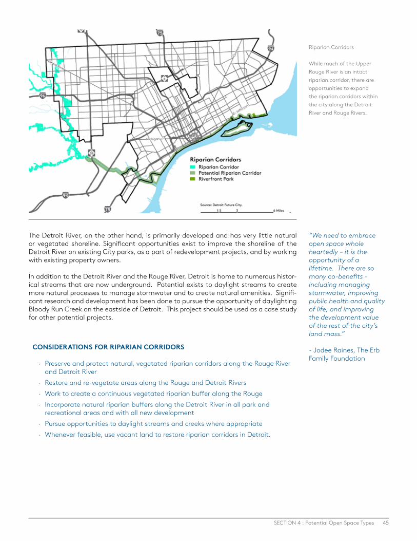
45SECTION 4 : Potential Open Space Types
The Detroit River, on the other hand, is primarily developed and has very little natural or vegetated shoreline. Significant opportunities exist to improve the shoreline of the Detroit River on existing City parks, as a part of redevelopment projects, and by working with existing property owners.
In addition to the Detroit River and the Rouge River, Detroit is home to numerous histor-ical streams that are now underground. Potential exists to daylight streams to create more natural processes to manage stormwater and to create natural amenities. Signifi-cant research and development has been done to pursue the opportunity of daylighting Bloody Run Creek on the eastside of Detroit. This project should be used as a case study for other potential projects.
“We need to embrace open space whole heartedly – it is the opportunity of a lifetime. There are so many co-benefits - including managing stormwater, improving public health and quality of life, and improving the development value of the rest of the city’s land mass.”
- Jodee Raines, The Erb Family Foundation
CONSIDERATIONS FOR RIPARIAN CORRIDORS
· Preserve and protect natural, vegetated riparian corridors along the Rouge River and Detroit River
· Restore and re-vegetate areas along the Rouge and Detroit Rivers · Work to create a continuous vegetated riparian buffer along the Rouge · Incorporate natural riparian buffers along the Detroit River in all park and
recreational areas and with all new development · Pursue opportunities to daylight streams and creeks where appropriate · Whenever feasible, use vacant land to restore riparian corridors in Detroit.
Riparian Corridors
While much of the Upper Rouge River is an intact riparian corridor, there are opportunities to expand the riparian corridors within the city along the Detroit River and Rouge Rivers.
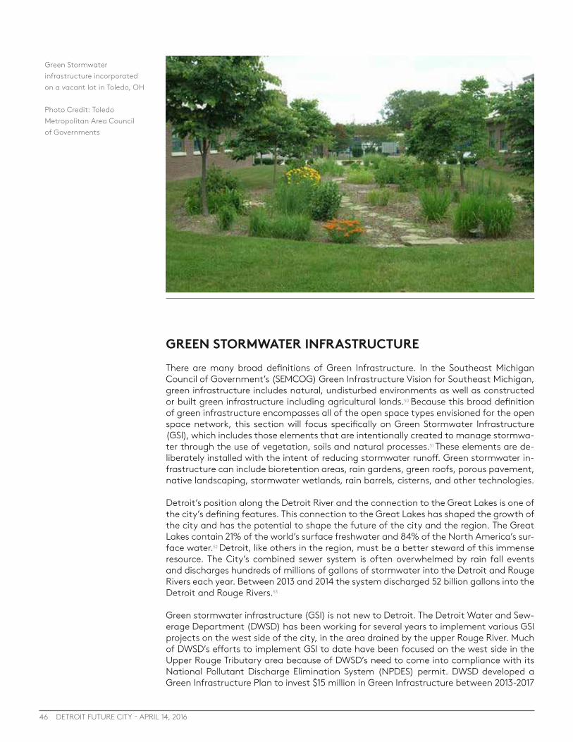
46 DETROIT FUTURE CITY - APRIL 14, 2016
GREEN STORMWATER INFRASTRUCTURE There are many broad definitions of Green Infrastructure. In the Southeast Michigan Council of Government’s (SEMCOG) Green Infrastructure Vision for Southeast Michigan, green infrastructure includes natural, undisturbed environments as well as constructed or built green infrastructure including agricultural lands.50 Because this broad definition of green infrastructure encompasses all of the open space types envisioned for the open space network, this section will focus specifically on Green Stormwater Infrastructure (GSI), which includes those elements that are intentionally created to manage stormwa-ter through the use of vegetation, soils and natural processes.51 These elements are de-liberately installed with the intent of reducing stormwater runoff. Green stormwater in-frastructure can include bioretention areas, rain gardens, green roofs, porous pavement, native landscaping, stormwater wetlands, rain barrels, cisterns, and other technologies.
Detroit’s position along the Detroit River and the connection to the Great Lakes is one of the city’s defining features. This connection to the Great Lakes has shaped the growth of the city and has the potential to shape the future of the city and the region. The Great Lakes contain 21% of the world’s surface freshwater and 84% of the North America’s sur-face water.52 Detroit, like others in the region, must be a better steward of this immense resource. The City’s combined sewer system is often overwhelmed by rain fall events and discharges hundreds of millions of gallons of stormwater into the Detroit and Rouge Rivers each year. Between 2013 and 2014 the system discharged 52 billion gallons into the Detroit and Rouge Rivers.53
Green stormwater infrastructure (GSI) is not new to Detroit. The Detroit Water and Sew-erage Department (DWSD) has been working for several years to implement various GSI projects on the west side of the city, in the area drained by the upper Rouge River. Much of DWSD’s efforts to implement GSI to date have been focused on the west side in the Upper Rouge Tributary area because of DWSD’s need to come into compliance with its National Pollutant Discharge Elimination System (NPDES) permit. DWSD developed a Green Infrastructure Plan to invest $15 million in Green Infrastructure between 2013-2017
Green Stormwater infrastructure incorporated on a vacant lot in Toledo, OH
Photo Credit: Toledo Metropolitan Area Council of Governments
47SECTION 4 : Potential Open Space Types
to reduce 2.8 million gallons of stormwater flow. The plan identifies a number of specific green infrastructure project types, including downspout disconnections, demolition and removal of vacant structures, bioswales along roadways and parking lots, tree planting and other projects.54 While the need to come into compliance with the NPDES permit along the Rouge River is important, GSI can and should be implemented throughout the city to limit the amount of stormwater and other effluent that is discharged into the Detroit River, and ultimately the Great Lakes. Communities throughout Detroit have begun to implement GSI projects, including a green alley in Midtown, a bioswale on Mack Avenue on the city’s eastside, and the Great Lakes Restoration Initiative on the lower eastside, which is using vacant land to manage stormwater through this federal program to protect and restore the Great Lakes.
GSI can be beneficial at all scales and in all locations in the city and should not be con-centrated in one or two areas of the city, but should be dispersed in order to relieve the burden on the storm sewer system. The type of GSI that can be implemented depends on the type of conditions in the area and whether it is in an area of growth, stabilization, or transformation. For example, areas of growth may focus on less land intensive GSI, such as green roofs, stormwater cisterns or rain barrels, or incorporating rain gardens into public right-of-way or existing parks. Areas of stabilization and areas of transforma-tion have more opportunities to use vacant land for GSI.
Detroit has a unique opportunity to use vacant land for GSI as a part of the larger open space network. GSI can be implemented on a single vacant side lot in a neighborhood or on multiple contiguous lots in high vacancy areas. As the primary open space func-tion, larger sites might include large bioretention areas or constructed wetlands while individual lots might incorporate stormwater designs from The Field Guide to Working with Lots. In addition, GSI can be incorporated into almost all other types of open space with varying levels of intervention. For example, the tree canopy and vegetation in nat-ural areas like buffers, forests, or prairies naturally manage stormwater and additional bioretention can be added with minor grade changes. Wetlands and riparian buffers al-ready effectively manage stormwater. GSI can also be incorporated into productive uses such as tree farms, biofuel production, or solar arrays if these areas are designed in an intentional way to manage stormwater. Rain gardens, bioretention areas, or constructed wetlands can also be incorporated into parks and recreation areas.
In locating green stormwater infrastructure throughout the open space network, priority should be given to locations adjacent to areas with large amounts of impervious surfac-es such as industrial areas, other highly developed areas, or roadways. As mentioned in the section on riparian corridors, areas adjacent to the Rouge River or the Detroit River should also be prioritized.
CONSIDERATIONS FOR GREEN STORMWATER INFRASTRUCTURE
· Incorporate green stormwater infrastructure throughout all areas of the city · Utilize vacant land to implement green stormwater infrastructure, particularly in
areas of transformation and areas of stabilization. · Use green stormwater infrastructure elements that work well in high density
environments in areas of growth. · Prioritize green stormwater infrastructure in locations adjacent to areas with high
amounts of impervious surface. · Incorporate green stormwater infrastructure throughout the open space network,
including having standalone GSI and incorporating it into parks, natural area, and productive areas.
The Great Lakes contain 21% of the world’s surface freshwater, 84% of the North America’s surface water.
“Open space could be a model for new infrastructure that plays a practical role in stormwater management while also providing an amenity to residents in the form of natural areas and recreation areas.”
- Libby Levy, Proseeds Consulting
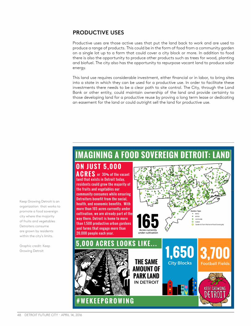
48 DETROIT FUTURE CITY - APRIL 14, 2016
PRODUCTIVE USESProductive uses are those active uses that put the land back to work and are used to produce a range of products. This could be in the form of food from a community garden on a single lot up to a farm that could cover a city block or more. In addition to food there is also the opportunity to produce other products such as trees for wood, planting and biofuel. The city also has the opportunity to repurpose vacant land to produce solar energy.
This land use requires considerable investment, either financial or in labor, to bring sites into a state in which they can be used for a productive use. In order to facilitate these investments there needs to be a clear path to site control. The City, through the Land Bank or other entity, could maintain ownership of the land and provide certainty to those developing land for a productive reuse by proving a long term lease or dedicating an easement for the land or could outright sell the land for productive use.
Keep Growing Detroit is an organization that works to promote a food sovereign city where the majority of fruits and vegetables Detroiters consume are grown by residents within the city’s limits.
Graphic credit: Keep Growing Detroit
# W E K E E P G R O W I N G
IMAGINING A FOOD SOVEREIGN DETROIT: LANDO N J U S T 5 , 0 0 0A C R E S
3,7001,650
1655 , 0 0 0 A C R E S L O O K S L I K E . . .
or 30% of the vacantland that exists in Detroit today,residents could grow the majority ofthe fruits and vegetables ourcommunity consumes while ensuringDetroiters benefit from the social,health, and economic benefits. Withmore than 165 acres currently undercultivation, we are already part of theway there. Detroit is home to morethan 1,500 productive urban gardensand farms that engage more than20,000 people each year.
THE SAMEAMOUNT OFPARK LAND
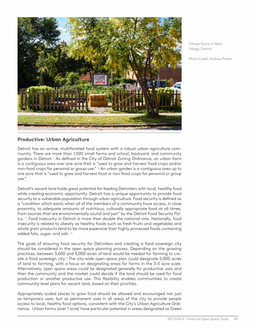
49SECTION 4 : Potential Open Space Types
Productive: Urban Agriculture
Detroit has an active, multifaceted food system with a robust urban agriculture com-munity. There are more than 1,500 small farms and school, backyard, and community gardens in Detroit.55 As defined in the City of Detroit Zoning Ordinance, an urban farm is a contiguous area over one acre that is “used to grow and harvest food crops and/or non-food crops for personal or group use.” 56 An urban garden is a contiguous area up to one acre that is “used to grow and harvest food or non-food crops for personal or group use.”
Detroit’s vacant land holds great potential for feeding Detroiters with local, healthy food while creating economic opportunity. Detroit has a unique opportunity to provide food security to a vulnerable population through urban agriculture. Food security is defined as a “condition which exists when all of the members of a community have access, in close proximity, to adequate amounts of nutritious, culturally appropriate food at all times, from sources that are environmentally sound and just” by the Detroit Food Security Pol-icy. 57 Food insecurity in Detroit is more than double the national rate. Nationally, food insecurity is related to obesity as healthy foods such as fresh fruits and vegetables and whole grain products tend to be more expensive than highly processed foods containing added fats, sugar, and salt. 58
The goals of ensuring food security for Detroiters and creating a food sovereign city should be considered in the open space planning process. Depending on the growing practices, between 3,600 and 5,000 acres of land would be needed for farming to cre-ate a food sovereign city.59 The city-wide open space plan could designate 5,000 acres of land to farming, with a focus on designating areas for farms in the 3-5 acre scale. Alternatively, open space areas could be designated generally for productive uses and then the community and the market could decide if the land should be used for food production or another productive use. This flexibility enables communities to create community-level plans for vacant land, based on their priorities. Appropriately scaled places to grow food should be allowed and encouraged not just as temporary uses, but as permanent uses in all areas of the city to provide people access to local, healthy food options, consistent with the City’s Urban Agriculture Ordi-nance. Urban farms (over 1 acre) have particular potential in areas designated as Green
Fisheye Farms in West Village, Detroit
Photo Credit: Andrew Potter

50 DETROIT FUTURE CITY - APRIL 14, 2016
Residential in the DFC Strategic Framework because these are areas where people live and where land is available. The CCP Report recommends that a majority of farming activities (especially at the 3- 5 acre scale) should be prioritized in Green Residential areas, but that some larger scale farming may be appropriate in transformation areas. Community gardens can be incorporated into mixed-use areas targeted for growth to improve quality of life and to provide access to food in higher density areas.
The open space planning process will identify environmentally critical areas, such as riparian corridors or wetlands, where ecological restoration should be prioritized and where agriculture should be avoided. In considering how urban agriculture fits into the larger open space network, the scale of agriculture and adjacent uses should be consid-ered. Urban livestock is another consideration in the location and scale of urban agriculture. The City of Detroit is currently working on an Urban Livestock Ordinance, which will pro-vide guidance on livestock in Detroit. Planning for livestock should focus on mitigating any potential nuisances with appropriate regulations including buffers and setbacks.
Indoor farming is also a part of the food system in Detroit. This can range from an accessory use like a greenhouse to a primary use like a tilapia farm. Indoor farming as a primary use will not directly be part of the open space network, but could be a consider-ation for the reutilization of vacant buildings that exist within the open space network.
With over 1,500 gardens and farms that are connected through the Garden Resource Program, Detroit’s food system community is strong and holds immense potential. In or-der to support and strengthen the work of the food system community in Detroit, there needs to be a facilitative environment that encourages and empowers local growers and food entrepreneurs. Fair and transparent policies are needed for accessing publicly owned vacant land and existing policies and regulations, such as the City’s Urban Agri-culture Ordinance, need to be reinforced and supported.
CONSIDERATIONS FOR URBAN AGRICULTURE · Support the existing urban agriculture ordinance by creating a review process for
farms over one acre. · Create a fair and transparent process for accessing public land (through
ownership and lease) for urban agriculture. · Ensure leadership, funding, and policy facilitates and encourages urban
agriculture as a permanent land use in Detroit. · Consider proximity to supportive uses related to processing and packaging,
especially for larger scale farming activities in order to leverage the full economic opportunity of the food system.
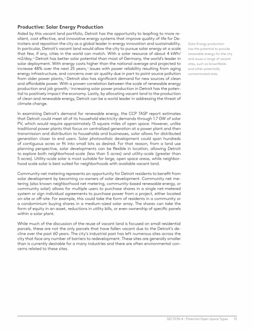
51SECTION 4 : Potential Open Space Types
Productive: Solar Energy ProductionAided by this vacant land portfolio, Detroit has the opportunity to leapfrog to more re-silient, cost effective, and innovative energy systems that improve quality of life for De-troiters and reposition the city as a global leader in energy innovation and sustainability. In particular, Detroit’s vacant land would allow the city to pursue solar energy at a scale that few, if any, cities in the world can match. With a solar resource of about 4 kWh/m2/day,60 Detroit has better solar potential than most of Germany, the world’s leader in solar deployment. With energy costs higher than the national average and projected to increase 48% over the next 25 years,61 issues with power reliability resulting from aging energy infrastructure, and concerns over air quality due in part to point source pollution from older power plants,62 Detroit also has significant demand for new sources of clean and affordable power. With a proven correlation between the scale of renewable energy production and job growth,63 increasing solar power production in Detroit has the poten-tial to positively impact the economy. Lastly, by allocating vacant land to the production of clean and renewable energy, Detroit can be a world leader in addressing the threat of climate change.
In examining Detroit’s demand for renewable energy, the CCP TASP report estimates that Detroit could meet all of its household electricity demands through 1.7 GW of solar PV, which would require approximately 13 square miles of open space. However, unlike traditional power plants that focus on centralized generation at a power plant and then transmission and distribution to households and businesses, solar allows for distributed generation closer to end users. Solar photovoltaic development could span hundreds of contiguous acres or fit into small lots as desired. For that reason, from a land use planning perspective, solar developments can be flexible in location, allowing Detroit to explore both neighborhood-scale (less than 5 acres) and utility-scale (greater than 5 acres). Utility-scale solar is most suitable for large, open space areas, while neighbor-hood scale solar is best suited for neighborhoods with available vacant land.
Community net metering represents an opportunity for Detroit residents to benefit from solar development by becoming co-owners of solar development. Community net me-tering (also known neighborhood net metering, community-based renewable energy, or community solar) allows for multiple users to purchase shares in a single net-metered system or sign individual agreements to purchase power from a project, either located on-site or off-site. For example, this could take the form of residents in a community or a condominium buying shares in a medium-sized solar array. The shares can take the form of equity in an asset, reductions in utility bills, or even ownership of specific panels within a solar plant.
While much of the discussion of the reuse of vacant land is focused on small residential parcels, these are not the only parcels that have fallen vacant due to the Detroit’s de-cline over the past 60 years. The city’s industrial past has left numerous sites across the city that face any number of barriers to redevelopment. These sites are generally smaller than is currently desirable for a many industries and there are often environmental con-cerns related to these sites.
Solar Energy production has the potential to provide renewable energy for the city and reuse a range of vacant sites, such as brownfields and other potentially contaminated sites.
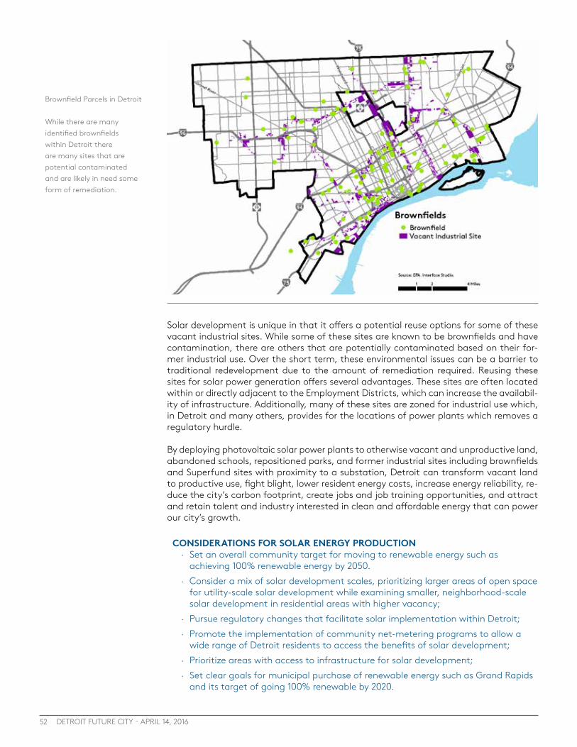
52 DETROIT FUTURE CITY - APRIL 14, 2016
CONSIDERATIONS FOR SOLAR ENERGY PRODUCTION · Set an overall community target for moving to renewable energy such as
achieving 100% renewable energy by 2050. · Consider a mix of solar development scales, prioritizing larger areas of open space
for utility-scale solar development while examining smaller, neighborhood-scale solar development in residential areas with higher vacancy;
· Pursue regulatory changes that facilitate solar implementation within Detroit; · Promote the implementation of community net-metering programs to allow a
wide range of Detroit residents to access the benefits of solar development; · Prioritize areas with access to infrastructure for solar development; · Set clear goals for municipal purchase of renewable energy such as Grand Rapids
and its target of going 100% renewable by 2020.
Solar development is unique in that it offers a potential reuse options for some of these vacant industrial sites. While some of these sites are known to be brownfields and have contamination, there are others that are potentially contaminated based on their for-mer industrial use. Over the short term, these environmental issues can be a barrier to traditional redevelopment due to the amount of remediation required. Reusing these sites for solar power generation offers several advantages. These sites are often located within or directly adjacent to the Employment Districts, which can increase the availabil-ity of infrastructure. Additionally, many of these sites are zoned for industrial use which, in Detroit and many others, provides for the locations of power plants which removes a regulatory hurdle.
By deploying photovoltaic solar power plants to otherwise vacant and unproductive land, abandoned schools, repositioned parks, and former industrial sites including brownfields and Superfund sites with proximity to a substation, Detroit can transform vacant land to productive use, fight blight, lower resident energy costs, increase energy reliability, re-duce the city’s carbon footprint, create jobs and job training opportunities, and attract and retain talent and industry interested in clean and affordable energy that can power our city’s growth.
Brownfield Parcels in Detroit
While there are many identified brownfields within Detroit there are many sites that are potential contaminated and are likely in need some form of remediation.

53SECTION 4 : Potential Open Space Types
The Solar Strand at the University of Buffalo is a solar project that has the potential to be a model for solar projects in the urban environment, particularly those that reuse vacant land. This solar project is built on 4 acres of the University of Buffalo campus. It provides 750 Kilowatts of electricity, which is enough to power approximately 700 student apartments.
What sets the Solar Strand apart from other solar projects is that it is focused on much more than the generation of renewable energy. This project creates a multidimensional space that is used by a wide range of groups. The site was designed by landscape architect Walter Hood and provides the public the opportunity to engage with the site. In addition to the solar panels, the site features meadow plantings and walkways between rows that allow this solar installation to engage with the community at large. Currently the site is being used as an educational tool to learn about solar energy.
CASE STUDY: SOLAR STRAND, BUFFALO, NY
Photo Credit: University of Buffalo:

54 DETROIT FUTURE CITY - APRIL 14, 2016
Productive: Biofuel, Tree Farms, and other Productive UsesBiofuel, tree farms, and other productive uses have potential as components of the fu-ture open space network. These uses have the potential to use land in a productive way that helps to clean the air, soil, and water but are also revenue generating with the potential to create jobs. The CCP TASP report highlights biofuel and tree farms from a fi-nancial standpoint and shows that both uses are viable uses in the open space network.
Vacant land can be used to grow biofuel, such as pennycress. The consideration for biofuel areas will depend on the type of biofuel being produced and the desires of the community. It will also depend on market forces that will make using vacant land for biofuel more economically viable.
Tree farms offer potential both for producing lumber but also for the cultivation of land-scape trees and plants. The CCP Report shows market demand for nursery trees as the city strives to plant more than a million trees to achieve a 30% canopy cover in Detroit. 64 In addition, there are few site constraints for tree farms and they can be located in areas where other open space uses are constrained. Tree farms do not necessarily need to be located on contiguous lots and do not have to be located in permanent open space areas, but could be redeveloped in 15 or more years, depending on the tree species. Tree farms also have potential for cleaning contaminated soil and managing stormwater.
The design of these productive uses provides opportunities to respond to community de-sires and to integrate into the community through intentional design of the farms. Fresh Coast Capital is an example of a tree farm that incorporates other productive crops and creates community-based designs.
CONSIDERATIONS FOR BIOFUEL, TREE FARMS AND OTHER PRODUCTIVE USES · Ensure productive uses such as biofuel, cut flowers, or tree farms are integrated
into the community in a way that improves quality of life. · Ensure productive uses are not located in environmentally critical areas, where
natural areas should be prioritized. · Identify and designate areas where large scale productive uses (over 5 acres)
are appropriate and desired by the community, such as transformation areas designated as Innovation Ecological or Innovation Productive
· Incorporate screening and transitions between uses as needed in siting proactive uses to ensure adjacent land uses are not negatively impacted from noises or smells.
Vacant land can be used to grow biofuel, such as pennycress, above. Pennycress on Mack Avenue on the eastside of Detroit.
Photo credit: Jackie Bejma, LAND, INC
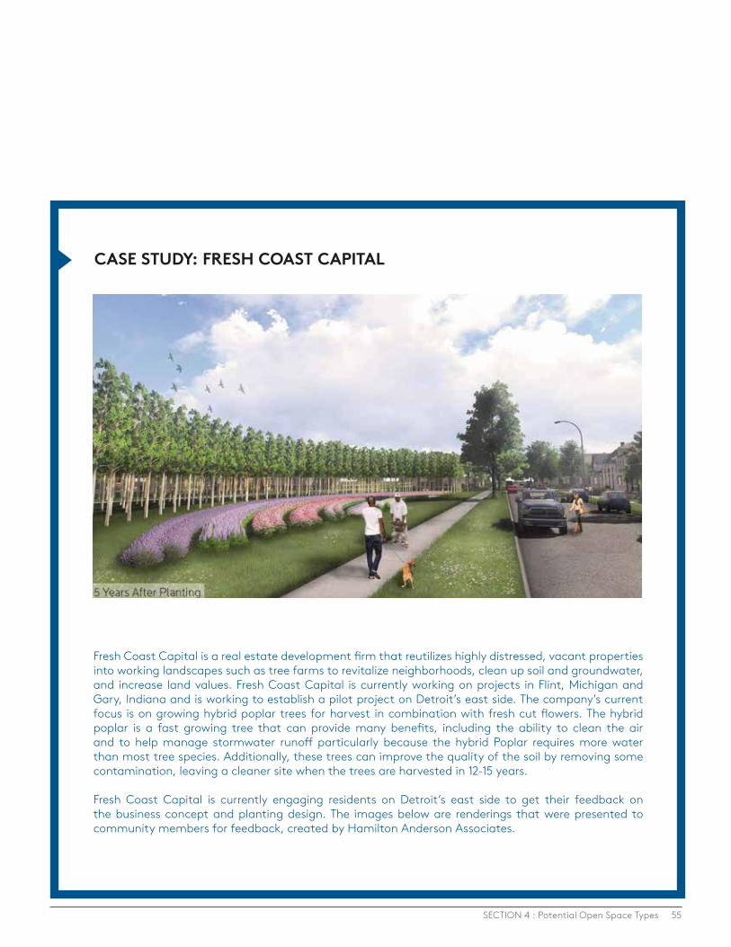
55
Fresh Coast Capital is a real estate development firm that reutilizes highly distressed, vacant properties into working landscapes such as tree farms to revitalize neighborhoods, clean up soil and groundwater, and increase land values. Fresh Coast Capital is currently working on projects in Flint, Michigan and Gary, Indiana and is working to establish a pilot project on Detroit’s east side. The company’s current focus is on growing hybrid poplar trees for harvest in combination with fresh cut flowers. The hybrid poplar is a fast growing tree that can provide many benefits, including the ability to clean the air and to help manage stormwater runoff particularly because the hybrid Poplar requires more water than most tree species. Additionally, these trees can improve the quality of the soil by removing some contamination, leaving a cleaner site when the trees are harvested in 12-15 years.
Fresh Coast Capital is currently engaging residents on Detroit’s east side to get their feedback on the business concept and planting design. The images below are renderings that were presented to community members for feedback, created by Hamilton Anderson Associates.
CASE STUDY: FRESH COAST CAPITAL
SECTION 4 : Potential Open Space Types
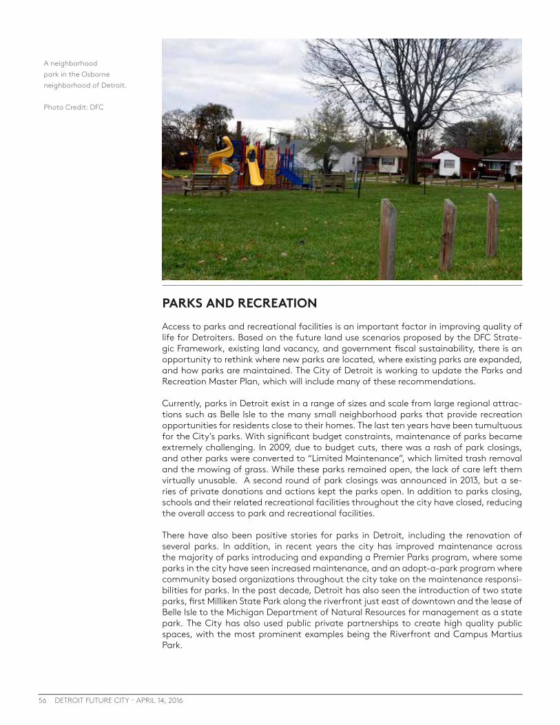
56 DETROIT FUTURE CITY - APRIL 14, 2016
PARKS AND RECREATIONAccess to parks and recreational facilities is an important factor in improving quality of life for Detroiters. Based on the future land use scenarios proposed by the DFC Strate-gic Framework, existing land vacancy, and government fiscal sustainability, there is an opportunity to rethink where new parks are located, where existing parks are expanded, and how parks are maintained. The City of Detroit is working to update the Parks and Recreation Master Plan, which will include many of these recommendations.
Currently, parks in Detroit exist in a range of sizes and scale from large regional attrac-tions such as Belle Isle to the many small neighborhood parks that provide recreation opportunities for residents close to their homes. The last ten years have been tumultuous for the City’s parks. With significant budget constraints, maintenance of parks became extremely challenging. In 2009, due to budget cuts, there was a rash of park closings, and other parks were converted to “Limited Maintenance”, which limited trash removal and the mowing of grass. While these parks remained open, the lack of care left them virtually unusable. A second round of park closings was announced in 2013, but a se-ries of private donations and actions kept the parks open. In addition to parks closing, schools and their related recreational facilities throughout the city have closed, reducing the overall access to park and recreational facilities.
There have also been positive stories for parks in Detroit, including the renovation of several parks. In addition, in recent years the city has improved maintenance across the majority of parks introducing and expanding a Premier Parks program, where some parks in the city have seen increased maintenance, and an adopt-a-park program where community based organizations throughout the city take on the maintenance responsi-bilities for parks. In the past decade, Detroit has also seen the introduction of two state parks, first Milliken State Park along the riverfront just east of downtown and the lease of Belle Isle to the Michigan Department of Natural Resources for management as a state park. The City has also used public private partnerships to create high quality public spaces, with the most prominent examples being the Riverfront and Campus Martius Park.
A neighborhood park in the Osborne neighborhood of Detroit.
Photo Credit: DFC
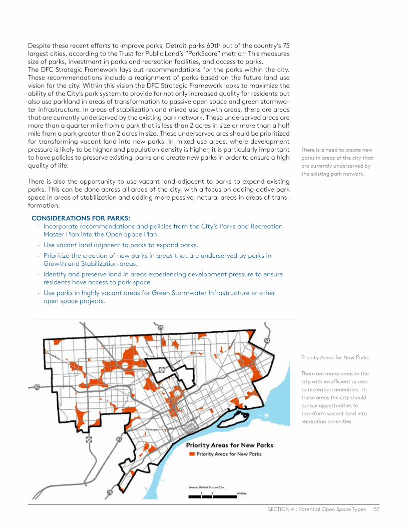
57SECTION 4 : Potential Open Space Types
Despite these recent efforts to improve parks, Detroit parks 60th out of the country’s 75 largest cities, according to the Trust for Public Land’s “ParkScore” metric.65 This measures size of parks, investment in parks and recreation facilities, and access to parks. The DFC Strategic Framework lays out recommendations for the parks within the city. These recommendations include a realignment of parks based on the future land use vision for the city. Within this vision the DFC Strategic Framework looks to maximize the ability of the City’s park system to provide for not only increased quality for residents but also use parkland in areas of transformation to passive open space and green stormwa-ter infrastructure. In areas of stabilization and mixed use growth areas, there are areas that are currently underserved by the existing park network. These underserved areas are more than a quarter mile from a park that is less than 2 acres in size or more than a half mile from a park greater than 2 acres in size. These underserved ares should be prioritized for transforming vacant land into new parks. In mixed-use areas, where development pressure is likely to be higher and population density is higher, it is particularly important to have policies to preserve existing parks and create new parks in order to ensure a high quality of life.
There is also the opportunity to use vacant land adjacent to parks to expand existing parks. This can be done across all areas of the city, with a focus on adding active park space in areas of stabilization and adding more passive, natural areas in areas of trans-formation.
CONSIDERATIONS FOR PARKS: · Incorporate recommendations and policies from the City’s Parks and Recreation
Master Plan into the Open Space Plan · Use vacant land adjacent to parks to expand parks. · Prioritize the creation of new parks in areas that are underserved by parks in
Growth and Stabilization areas. · Identify and preserve land in areas experiencing development pressure to ensure
residents have access to park space. · Use parks in highly vacant areas for Green Stormwater Infrastructure or other
open space projects.
There is a need to create new parks in areas of the city that are currently underserved by the existing park network.
Priority Areas for New Parks
There are many areas in the city with insufficient access to recreation amenities. In these areas the city should pursue opportunities to transform vacant land into recreation amenities.

58 DETROIT FUTURE CITY - APRIL 14, 2016
Parks and Recreation: GreenwaysIn addition to Detroit’s park system, greenways, trails, and bike lanes provide a unique opportunity to connect all open space areas with other areas of activities and destina-tions throughout the city, while providing recreational opportunities and important al-ternative transportation options. Over the past 10 years there have been more than 150 miles of cycling infrastructure added to roads in Detroit.66 This increase in infrastructure has led to an increase in cycling.67 There are currently plans to continue the expansion of bike lanes and greenways in Detroit, including the Inner Circle Greenway, which is a 26 mile loop much of which consists of abandoned rail right of way.
These important non-motorized connections are what will ensure the open space system is an interconnected network. Pedestrian and bike infrastructure can be added as part of the existing right-of-way on roads throughout Detroit (see the City of Detroit’s Non-Mo-torized Plan) but there is also an opportunity to utilize vacant land to create greenways through open space areas and neighborhoods. Locating greenways on vacant land that is adjacent to key streets could increase the visibility and use of the greenway while providing protected non-motorized transportation options
CONSIDERATIONS FOR GREENWAYS: · Incorporate all existing greenway and non-motorized efforts into the open space
plan. · Continue to expand non-motorized infrastructure to connect the open space
network with other destinations. · Utilize vacant land, extra right-of-way capacity, or existing parks and open spaces
to create an interconnected greenway system
The Dequindre Cut in Detroit connects the Detroit Riverfront to Eastern Market.
Photo Credit: Detroit Riverfront Conservancy
“There are benefits to having all this open space. We have the opportunity to work with communities to create off-street greenways and to use non-motorized trails to connect different areas in the city.”
- Todd Scott, Detroit Greenways Coalition

59SECTION 4 : Potential Open Space Types
BUFFERSBuffers are vegetated areas located around highways and industrial areas that utilize plant materials to block hazardous particulate matter, absorb noxious fumes, and help reduce visual and sound impacts.
The legacy of Detroit’s freeway network, which was designed to move automobile traffic quickly and efficiently throughout the city and region, has had many profound impacts on the city. This network was created well after the city had formed so the expansive stretches of road cut through neighborhoods and displaced many residents. Many more residents found themselves living directly adjacent to these new freeways, which has had a significant negative impact on public health in the city’s neighborhoods.
There are a range of air pollutants that can be found in high concentrations near the city’s freeways as a result of automobile and truck traffic, including particulate matter (PM), Carbon Monoxide (CO), Nitrogen Oxides (NOx) and others. These pollutants have been found to contribute to a range of negative health impacts including asthma and cardiovascular disease. Research has shown that elevated levels of pollution related to the auto and truck traffic associated with freeways is highest within 500 ft of these roadways.66
There are ways to mitigate the negative effects of living close to a freeway. Research indicates that vegetation, particularly trees, have positive effects on reducing the pres-ence of auto and truck related pollution adjacent to freeways. This research also indi-cates that a range of tree types including coniferous trees, which remain green all year, can have the most positive influence on air quality adjacent to roadways.67
Forested Buffers
The Strategic Framework describes two types of forested buffers: Carbon Forest which are located along expressways and buffer residents from associated pollution and Industrial Buffers which are located adjacent to industrial sites and can mitigate the effects of living adjacent to industry.

60 DETROIT FUTURE CITY - APRIL 14, 2016
In order to improve the health of residents who live near freeways, the DFC Strategic Framework recommends planting carbon forests as buffers along freeways in the city. There are different options for plantings in the creation of this network. The first is plant-ings within the right-of-way, which can be achieved on the embankment, medians, and interchanges. In addition to these plantings within the right-of-way, there are opportu-nities to expand these carbon buffers from the right-of-way and locate them on vacant land that is within 500 ft. of expressways. The carbon forest will act to absorb CO2 emissions from automobiles and prevent pollutants from reaching adjacent residents. Simultaneously, carbon forests will create a visual amenity both for passing traffic and for residents living adjacent to freeways.
In addition to carbon forests, trees can be used to buffer residents from the negative qualities of living directly adjacent to industry. As the city formed, industrial lands were located directly adjacent to the city’s neighborhoods. In addition, new industrial facili-ties have located directly adjacent to residential neighborhoods, or in some cases, have taken over residential land.
Having industry in Detroit provides numerous economic benefits and having industry in close proximity to residents provides access to jobs for Detroiters, but these bene-fits need to be balanced with preserving and enhancing quality of life for Detroiters. Depending on the type and intensity of the industry, there can be potential negative impacts to adjacent residential property, including noise, smell, air pollution, and visual impacts. Because of these negative impacts, many residential neighborhoods that are directly adjacent to industry have declined over the years.
Vegetated buffers, or Carbon Buffers, along highways buffer residents from associated pollution, noise, and visual impacts of living next to highways.

61SECTION 4 : Potential Open Space Types
CONSIDERATIONS FOR BUFFERS · Work with all appropriate transportation agencies to begin planting carbon
forests along freeways in the public right-of-way, where feasible. · Identify vacant land within 500 feet of freeways for planting carbon buffers. · Identify vacant land adjacent to industry in residential neighborhoods that could
be planted with forested buffers. · Update zoning requirements for industrial development to require forested buffers
for new industrial development locating adjacent to residential property. · Incorporate evergreen and deciduous trees in all buffers to ensure the seasonal
interest and environmental benefits. · Incorporate greenways into buffers where appropriate.
One way to protect residents who live near industrial facilities is through the imple-mentation of setbacks and forested buffers adjacent to these uses. These buffers can improve air quality, reduce noise and smells, and provide an attractive visual barrier for surrounding residential properties.
There are several ways that these buffers can be implemented. For existing industrial areas, buffers can be planted on the industrial property where there is space, on adja-cent vacant land, or a combination of the two. For new industrial development, buffers and setbacks should be required if locating adjacent to a residential area. Tools such as conservation easements or development agreement can be used to ensure buffers are retained over time.
Because buffers tend to be linear in nature, there is an opportunity to incorporate green-ways into buffers where appropriate and there is an opportunity to incorporate buffers into the planning of greenways.
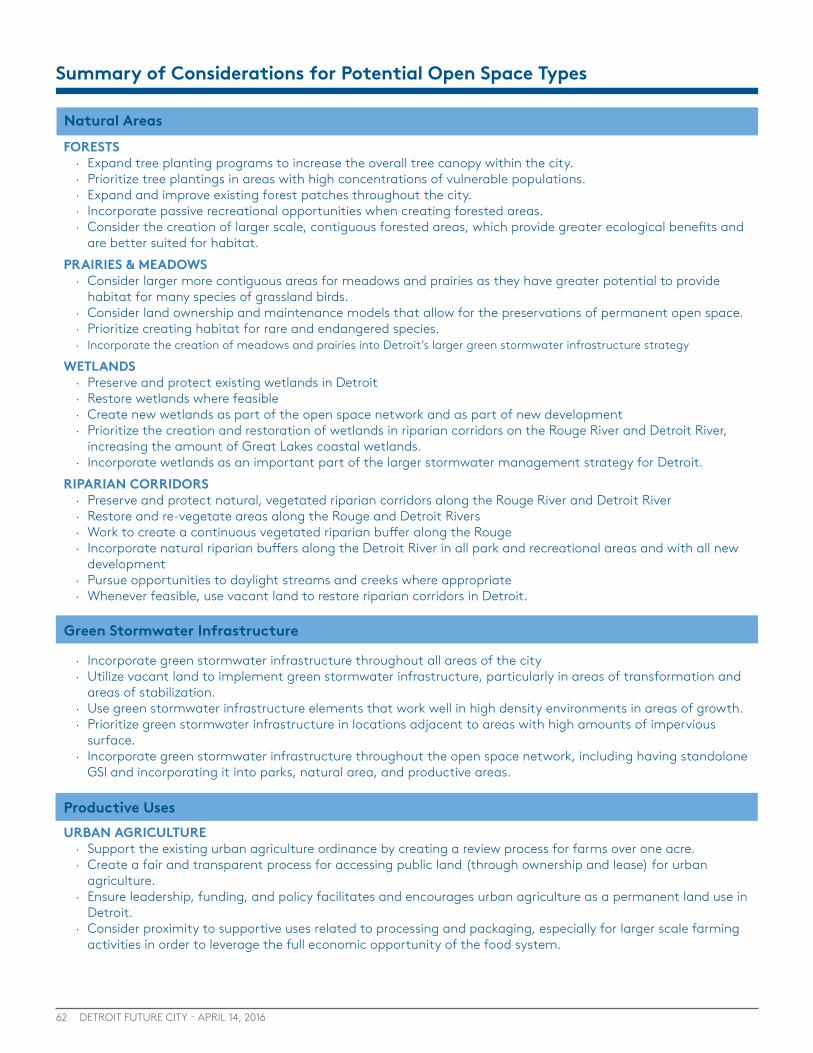
62 DETROIT FUTURE CITY - APRIL 14, 2016
FORESTS · Expand tree planting programs to increase the overall tree canopy within the city. · Prioritize tree plantings in areas with high concentrations of vulnerable populations. · Expand and improve existing forest patches throughout the city. · Incorporate passive recreational opportunities when creating forested areas. · Consider the creation of larger scale, contiguous forested areas, which provide greater ecological benefits and
are better suited for habitat.PRAIRIES & MEADOWS
· Consider larger more contiguous areas for meadows and prairies as they have greater potential to provide habitat for many species of grassland birds.
· Consider land ownership and maintenance models that allow for the preservations of permanent open space. · Prioritize creating habitat for rare and endangered species. · Incorporate the creation of meadows and prairies into Detroit’s larger green stormwater infrastructure strategy
WETLANDS · Preserve and protect existing wetlands in Detroit · Restore wetlands where feasible · Create new wetlands as part of the open space network and as part of new development · Prioritize the creation and restoration of wetlands in riparian corridors on the Rouge River and Detroit River,
increasing the amount of Great Lakes coastal wetlands. · Incorporate wetlands as an important part of the larger stormwater management strategy for Detroit.
RIPARIAN CORRIDORS · Preserve and protect natural, vegetated riparian corridors along the Rouge River and Detroit River · Restore and re-vegetate areas along the Rouge and Detroit Rivers · Work to create a continuous vegetated riparian buffer along the Rouge · Incorporate natural riparian buffers along the Detroit River in all park and recreational areas and with all new
development · Pursue opportunities to daylight streams and creeks where appropriate · Whenever feasible, use vacant land to restore riparian corridors in Detroit.
Summary of Considerations for Potential Open Space Types
· Incorporate green stormwater infrastructure throughout all areas of the city · Utilize vacant land to implement green stormwater infrastructure, particularly in areas of transformation and
areas of stabilization. · Use green stormwater infrastructure elements that work well in high density environments in areas of growth. · Prioritize green stormwater infrastructure in locations adjacent to areas with high amounts of impervious
surface. · Incorporate green stormwater infrastructure throughout the open space network, including having standalone
GSI and incorporating it into parks, natural area, and productive areas.
URBAN AGRICULTURE · Support the existing urban agriculture ordinance by creating a review process for farms over one acre. · Create a fair and transparent process for accessing public land (through ownership and lease) for urban
agriculture. · Ensure leadership, funding, and policy facilitates and encourages urban agriculture as a permanent land use in
Detroit. · Consider proximity to supportive uses related to processing and packaging, especially for larger scale farming
activities in order to leverage the full economic opportunity of the food system.
Green Stormwater Infrastructure
Productive Uses
Natural Areas

63SECTION 4 : Potential Open Space Types
Parks and Recreation
SOLAR ENERGY PRODUCTION · Set an overall community target for moving to renewable energy such as achieving 100% renewable energy by
2050. · Consider a mix of solar development scales, prioritizing larger areas of open space for utility-scale solar
development while examining smaller, neighborhood-scale solar development in residential areas with higher vacancy;
· Pursue regulatory changes that facilitate solar implementation within Detroit; · Promote the implementation of community net-metering programs to allow a wide range of Detroit residents
to access the benefits of solar development; · Prioritize areas with access to infrastructure for solar development; · Set clear goals for municipal purchase of renewable energy such as Grand Rapids and its target of going 100%
renewable by 2020. BIOFUEL, TREE FARMS AND OTHER PRODUCTIVE USES
· Ensure productive uses such as biofuel, cut flowers, or tree farms are integrated into the community in a way that improves quality of life.
· Ensure productive uses are not located in environmentally critical areas, where natural areas should be prioritized.
· Identify and designate areas where large scale productive uses (over 5 acres) are appropriate and desired by the community, such as transformation areas designated as Innovation Ecological or Innovation Productive
· Incorporate screening and transitions between uses as needed in siting proactive uses to ensure adjacent land uses are not negatively impacted from noises or smells.
PARKS · Incorporate recommendations and policies from the City’s Parks and Recreation Master Plan into the Open
Space Plan · Use vacant land adjacent to parks to expand parks. · Prioritize the creation of new parks in areas that are underserved by parks in Growth and Stabilization areas. · Identify and preserve land in areas experiencing development pressure to ensure residents have access to park
space. · Use parks in highly vacant areas for Green Stormwater Infrastructure or other open space projects.
GREENWAYS · Incorporate all existing greenway and non-motorized efforts into the open space plan. · Continue to expand non-motorized infrastructure to connect the open space network with other destinations. · Utilize vacant land, extra right-of-way capacity, or existing parks and open spaces to create an interconnected
greenway system · Identify vacant land within 500 feet of freeways for planting carbon buffers. · Work with all appropriate transportation agencies to begin planting carbon forests along freeways in the public
right-of-way, where feasible.
Buffers
· Identify vacant land within 500 feet of freeways for planting carbon buffers. · Identify vacant land adjacent to industry in residential neighborhoods that could be planted with forested
buffers. · Update zoning requirements for industrial development to require forested buffers for new industrial
development locating adjacent to residential property. · Incorporate evergreen and deciduous trees in all buffers to ensure the seasonal interest and environmental
benefits. · Incorporate greenways into buffers where appropriate.
Productive Uses (continued)
Land Ownership, Assembly, and Disposition5
Photo Credit: M. Shaouni
65
LAND OWNERSHIP, ASSEMBLY, AND DISPOSITION5
SECTION 5 : Land Ownership
In order to achieve an integrated open space network in Detroit, an open space planning process will have to consider who will own and maintain the land for different types of open space and how the land will be assembled over time. The CCP Report “Open Space in Detroit: Key Ownership and Funding Considerations to Inform a Comprehensive Open Space Planning Process” identifies several land ownership models that could be em-ployed by Detroit leaders to acquire and manage open space. The report also identifies and describes land management tools that could be employed to support long-term open space land use plans and goals. Below is a summary of the of these options, but see the CCP for full details.
OWNERSHIPThere are a range of options for the ownership of land that is part of a larger open space network. Each type of ownership structure has its own set of positive attributes and there is not necessarily one “right” model for ownership. The decision regarding which ownership structure to employ for different types and scales of open space must ultimately be guided by policy and planning considerations. The CCP report uses the following considerations to evaluate the different ownership structures: · Future authority over open space
· Land acquisition and disposition ability
· Future tax revenue/liability
· Liability
· Funding opportunities
Generally, there are two main classifications of ownership: public and private. The section that follows lists the different types of entities, both public and private, that can assist in the implementation of an integrated open space network. With any of the options described below that would transfer land from the City to another entity, the City should ensure there are legal regulations and policies in place to ensure these entities continue to implement the City’s open space vision over time. In particular, policies should be in place to ensure these other entities (like the State of Michigan or a land trust) work with the community to empower residents and build partnerships.
Public Ownership
CITY OWNERSHIPThe City of Detroit, up until recently, owned the majority of vacant land within Detroit, through the Planning and Development Department. In addition, the City of Detroit currently owns around 5,800 acres of land for the management and operation of parks and recreational space.
While the ability to hold and control land can provide the City with a greater degree of authority over the implementation of the open space network, there are constraints placed on the City, such as the requirement for the approval of City Council before disposing or acquiring land. As a result, the City may be most useful as the holder and
For more details on all of these recommendations, please see the full CCP report:
http://detroitfuturecity.com/wp-content/uploads/2015/11/151022_CommunityProgress_TASP_DFC_Report.pdf
Inside this Section
65 Ownership
70 Assembly and Disposition
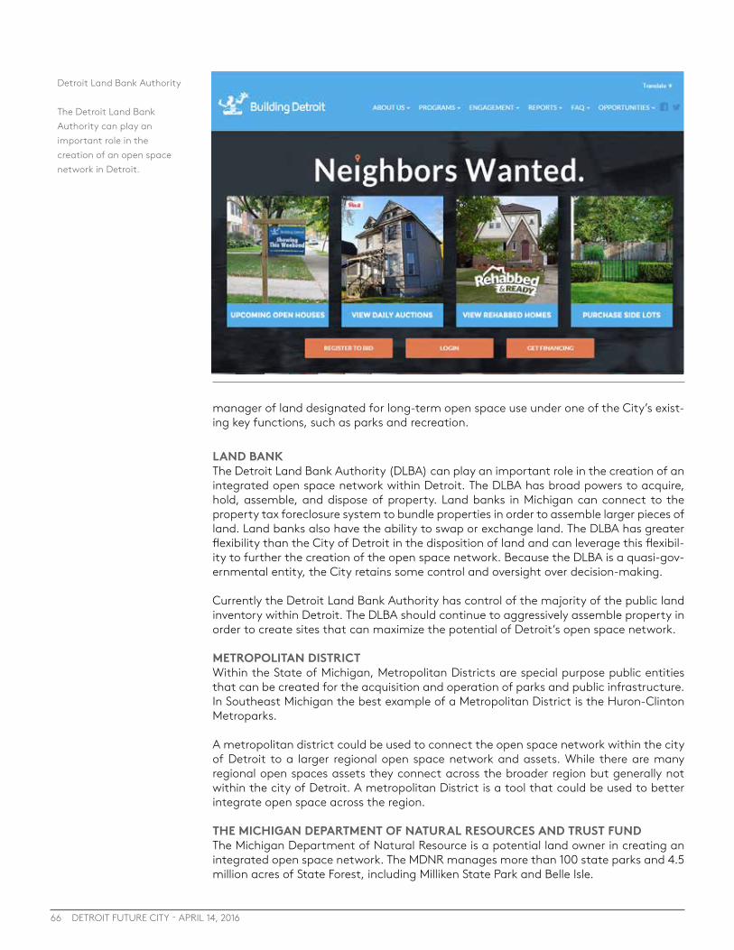
66 DETROIT FUTURE CITY - APRIL 14, 2016
manager of land designated for long-term open space use under one of the City’s exist-ing key functions, such as parks and recreation.
LAND BANKThe Detroit Land Bank Authority (DLBA) can play an important role in the creation of an integrated open space network within Detroit. The DLBA has broad powers to acquire, hold, assemble, and dispose of property. Land banks in Michigan can connect to the property tax foreclosure system to bundle properties in order to assemble larger pieces of land. Land banks also have the ability to swap or exchange land. The DLBA has greater flexibility than the City of Detroit in the disposition of land and can leverage this flexibil-ity to further the creation of the open space network. Because the DLBA is a quasi-gov-ernmental entity, the City retains some control and oversight over decision-making.
Currently the Detroit Land Bank Authority has control of the majority of the public land inventory within Detroit. The DLBA should continue to aggressively assemble property in order to create sites that can maximize the potential of Detroit’s open space network.
METROPOLITAN DISTRICTWithin the State of Michigan, Metropolitan Districts are special purpose public entities that can be created for the acquisition and operation of parks and public infrastructure. In Southeast Michigan the best example of a Metropolitan District is the Huron-Clinton Metroparks.
A metropolitan district could be used to connect the open space network within the city of Detroit to a larger regional open space network and assets. While there are many regional open spaces assets they connect across the broader region but generally not within the city of Detroit. A metropolitan District is a tool that could be used to better integrate open space across the region.
THE MICHIGAN DEPARTMENT OF NATURAL RESOURCES AND TRUST FUNDThe Michigan Department of Natural Resource is a potential land owner in creating an integrated open space network. The MDNR manages more than 100 state parks and 4.5 million acres of State Forest, including Milliken State Park and Belle Isle.
Detroit Land Bank Authority
The Detroit Land Bank Authority can play an important role in the creation of an open space network in Detroit.
67SECTION 5 : Ownership
The Michigan Department of Natural Resources also has access to a range of funding streams that could be used for the implementation of open space within the city of De-troit. These include the Natural Resource Trust Fund and several others. However, while these funding streams exist there may need to be changes in legislation to direct more of these sources of funding for the implementation of open space in Detroit. Private OwnershipIn addition to the parts of the open space network that will remain publicly owned, there are different private entities that can be used to facilitate the creation of a connected open space network. Not all parts of an open space network need to remain in public control and private entities can be powerful partners in establishing and maintaining parts of the network. A description of four different types of private entities that can help create an open space network is included below.
LAND TRUST AND LAND CONSERVANCYLand trusts and land conservancies are non-profit, private ownership structures that are used throughout Michigan and the country to own and manage large inventories of vacant land. Generally, land trusts are created to acquire and own land while land con-servancies manage and operate programs on the land. These non-profit organizations often partner with one another to further their missions. In an urban environment like Detroit, a land trust and land conservancy would not only be tasked with acquisition of land, but the creation of an open space amenity from previously developed land.
A land trust could be used in the creation and management of several parts of the open space network, but they are likely most suited for the creation and management of natural areas such as forests, riparian areas, or wetlands. Land conservancies, such as the Detroit Riverfront Conservancy, can work to manage and operate publicly owned land. Other examples of land conservancies or trusts that operate in Michigan, but not in Detroit include SEMI WILD, Heart of the Lakes, and the Michigan Nature Association.
Simply creating a land trust or conservancy does not ensure the creation of open space. These non-profits need to do significant fundraising to ensure they can fund the pur-chase of land and the legacy costs of maintaining open space over time.
A few of the land trusts and land conservancies that operate in Southeast Michigan.
68 DETROIT FUTURE CITY - APRIL 14, 2016
COMMUNITY LAND TRUSTSCommunity land trusts are another ownership model that can be adapted to contrib-ute to the creation and management of an integrated open space network. While the community land trust model has typically been used to preserve permanent affordable housing, the model can be adapted to a range of other situations, including open space development.
At the core of the community land trust model is community ownership of land and participation by the community, often with a board comprised of community members. While the community land trust owns the land, it is leased to others to make improve-ments upon that land. This could provide a model for stable ownership and allow those wishing to make open space improvements to be able to secure financing.
An example of a community land trust that preserves open space is the Southside Com-munity Land Trust, which provides long-term leases at low rates to farmers and runs community gardens all over greater Providence, RI. They also provide programmatic support by delivering supplies and technical training to gardens and farms.
LAND COOPERATIVELand cooperatives are a type of organization that can be used to reuse and manage land as part of the open space network. Under the land cooperative model, land would be owned and maintained by a group of individuals. Land cooperatives are most effective when they control a defined area and have clear goals and mission for the stewardship of open space. This model could be effective for block level interventions and maintain-ing a few parcels within a neighborhood.
PRIVATE INDIVIDUALS AND COMPANIESIn addition to the organizations listed above, private individuals and companies can own and maintain parts of the open space network. While consolidation of the open space network into fewer owners is generally recommended, there are cases where private individuals and companies may be the most appropriate to implement part of the open space network. This is particularly relevant for productive uses such as urban agriculture, energy production, or tree farms. In these cases, there is an opportunity to use legal and regulatory tools to protect the open space over time while allowing entrepreneurial private individuals or companies to own and maintain productive open space. Some of these legal tools are described in the following section.
Private Ownership Legal ToolsAs land for open space is sold to different owners, a range of legal tools should be con-sidered to ensure that land remains a permanent part of the open space network. The following tools should be considered to ensure the long term implementation of an open space network.
DEED RESTRICTIONSDeed restrictions are a powerful tool that can be used to limit the types of development that can occur on a site. These restrictions can be attached to the property and be used to regulate many aspects of development upon any piece of land. Deed restrictions may provide that land sold to a private third party may never be developed, that land may be developed for only a particular purpose related to open space, or that the use of certain kinds of materials are restricted in development on the parcel. This tool can limit conventional development and create permanent parts of the open space network. For more details, see page 26 of the CCP Open Space Report.
CONSERVATION EASEMENTSAn easement is a right to use all or a portion of an owner’s land for a specified purpose. In the creation of an open space network, conservation easements could be held on land by the City or other land owner to ensure the land is retained as open space and is not

69SECTION 5 : Ownership
developed over time. For more details on conservation easements, see page 27 of the CCP Open Space Report.
LEASESLeases can be used to provide the land holder with a large degree of control in creating the open space network. While the land holder, such as the City, DLBA, or land trust, will retain ownership, the management of the property will be shifted to a private indi-vidual or group. These can be used for temporary open space uses or where uses have the potential to expand over time. For example, the Michigan Department of Natural Resources leases land and conservation easements it owns along the Detroit river to the Detroit Riverfront Conservancy (DRFC) for the DRFC to manage and operate the Detroit Riverfront.
DEVELOPMENT RIGHTS AGREEMENTSDevelopment Rights Agreements (DRAs) are similar to conservation easement and deed restrictions, except they have a limited timeframe, between 10 and 90 years. Using a DRA, the City could sell land but retain a portion of the development rights on that land and limit what can be built. In practice, DRAs are used primarily in agriculture as a way of preserving farms and farmland in Michigan, but they may also be used to preserve open space, riverfronts, and other natural areas. For more details on DRAs, see page 28 of the CCP Open Space Report
ConclusionThe CCP report offers initial guidance on ownership considerations for the long and near term, which can serve as a starting point for future open space planning, conversations, and advocacy. As Detroit leaders consider various ownership models for large quanti-ties of land there are two important factors that should inform the overall approach to examining ownership structures. First, no particular legal structure for holding and maintaining a large inventory of land will obviate the need for funding to acquire and maintain that inventory. Different ownership structures can create efficiencies and econ-omies of scale, can have tax implications, and can minimize risk and provide confidence for potential funders, but no particular ownership structure will itself generate funding. Second, and perhaps most important, the particular legal structure of ownership and holding of currently vacant land in Detroit must be decided based on the goals and planned use for that land.
Considerations for Ownership (from the CCP Report): · Limit open space ownership fragmentation, as much as possible.
· Avoid single parcel or small-scale disposition in open space areas.
· Ensure use consistency with the overall vision as disposition or leasing occurs.
· Enable some flexibility in ownership and disposition.
· Consider property tax implications when transferring ownership of open space.
Short term considerations for Ownership: · Proactively and aggressively assemble and hold land in open space areas using Detroit Land
Bank Authority.
· Engage in shorter term leases for land uses in open space areas that are consistent with DFC’s vision.
· Do not sell land in open space areas until the Master Plan of Policies, Zoning Ordinance, and Open Space Plan are officially adopted, other than limited side lot transfers.

70 DETROIT FUTURE CITY - APRIL 14, 2016
ASSEMBLY AND DISPOSITIONMuch of Detroit’s vacant land portfolio is on scattered sites, so strategic land assembly, holding, and disposition policies and actions are needed in order to achieve a cohesive open space network over time. The Detroit Future City Strategic Framework lays out a land use framework that can be used to guide decision-making around the assembly and disposition of land within the Detroit, but an open space plan is needed to provide more specific guid-ance based on the desired open space types. Depending on the area of the city and the type of desired open space, the assembly, holding, and disposition strategies will vary.
Assembling land to create contiguous areas of open space is an important strategy to achieve the open space network, especially for those open space types that require larger, contiguous areas such as areas that provide habitat. Land swaps hold potential as a tool to assemble contiguous properties to achieve a more impactful open space network, partic-ularly for greenways or other open space types where contiguity is critical. Land assembly can take time, in some cases generations, so a holding strategy during assembly is also critical. Because the land assembly and holding strategies could take years or decades, there needs to be clear strategies for temporary uses that work to stabilize and improve quality of life for residents and businesses nearby. For example, if the open space planning process identifies an area for a permanent prairie in one area of the city to provide important habitat and stormwater management, but the area currently has a variety of uses and ownership, the interim strategy could be to hold the publicly owned vacant land and create smaller scattered meadows with a long term goal of creating a connected prairie. The scattered meadows would still have significant positive impacts on stormwater and on quality of life while working to assemble a larger site.
Land disposition should also have a similar strategic approach that works to achieve the open space vision. Land identified as part of the open space network should only be sold or leased in alignment with the open space vision. For example, areas that are identified for productive uses, such as urban agriculture or tree farms, could be sold or given a long-term lease to farmers or entrepreneurs. Sale or lease of land may include some type of develop-ment agreement or land use designation that indicates the type of open space the land is to be used for. The strategies for the assembly, holding, and disposition of land across the city will vary but should conform to the broad goals for an area. The following section details recommenda-tions for the areas of the city based on the DFC Strategic Framework, Areas of Growth, Sta-bilization and transformation. While there are many reasons the city can assemble, dispose and hold land, this section focuses on the strategies to aid in the implementation of the open space network.
Areas of GrowthIn Areas of Growth the focus is on redevelopment to expand the job base of the city and to create desirable mixed use areas that attract a range of residents. While not the primary focus in areas of growth, open space can play a critical role in improving quality of life for residents in these areas and the areas that are directly adjacent.
Near industrial areas, an open space plan should identify land that is appropriate for indus-trial buffers. In these areas land should be assembled and held to facilitate the creation of these vegetated buffers.
In mixed-use areas it is important to consider parks and other community open spaces that can improve quality of life. While the development pressure is growing in these areas, the needs of current and future residents should be considered. In areas where there is a lack of open space, sites should be assembled and preserved for the creation of parks, community gardens, or other greens space to increase quality of life for residents. After these sites are set aside, other sites can then be prioritized for redevelopment to achieve increased density. If these potential redevelopment sites do not have an immediate reuse option, the land could be leased for temporary use until a time when there is a development that is compatible with the future vision for that area.
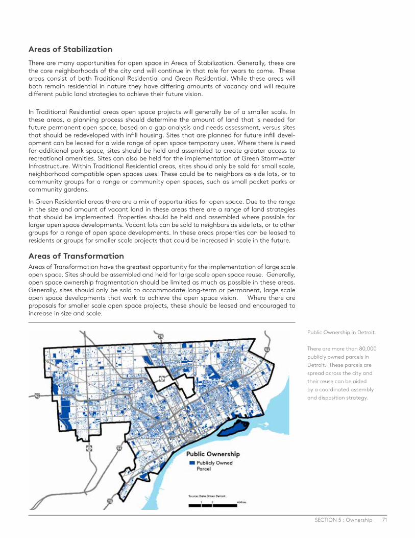
71SECTION 5 : Ownership
Areas of StabilizationThere are many opportunities for open space in Areas of Stabilization. Generally, these are the core neighborhoods of the city and will continue in that role for years to come. These areas consist of both Traditional Residential and Green Residential. While these areas will both remain residential in nature they have differing amounts of vacancy and will require different public land strategies to achieve their future vision.
In Traditional Residential areas open space projects will generally be of a smaller scale. In these areas, a planning process should determine the amount of land that is needed for future permanent open space, based on a gap analysis and needs assessment, versus sites that should be redeveloped with infill housing. Sites that are planned for future infill devel-opment can be leased for a wide range of open space temporary uses. Where there is need for additional park space, sites should be held and assembled to create greater access to recreational amenities. Sites can also be held for the implementation of Green Stormwater Infrastructure. Within Traditional Residential areas, sites should only be sold for small scale, neighborhood compatible open spaces uses. These could be to neighbors as side lots, or to community groups for a range or community open spaces, such as small pocket parks or community gardens.
In Green Residential areas there are a mix of opportunities for open space. Due to the range in the size and amount of vacant land in these areas there are a range of land strategies that should be implemented. Properties should be held and assembled where possible for larger open space developments. Vacant lots can be sold to neighbors as side lots, or to other groups for a range of open space developments. In these areas properties can be leased to residents or groups for smaller scale projects that could be increased in scale in the future.
Areas of TransformationAreas of Transformation have the greatest opportunity for the implementation of large scale open space. Sites should be assembled and held for large scale open space reuse. Generally, open space ownership fragmentation should be limited as much as possible in these areas. Generally, sites should only be sold to accommodate long-term or permanent, large scale open space developments that work to achieve the open space vision. Where there are proposals for smaller scale open space projects, these should be leased and encouraged to increase in size and scale.
Public Ownership in Detroit
There are more than 80,000 publicly owned parcels in Detroit. These parcels are spread across the city and their reuse can be aided by a coordinated assembly and disposition strategy.
Funding and Financing6
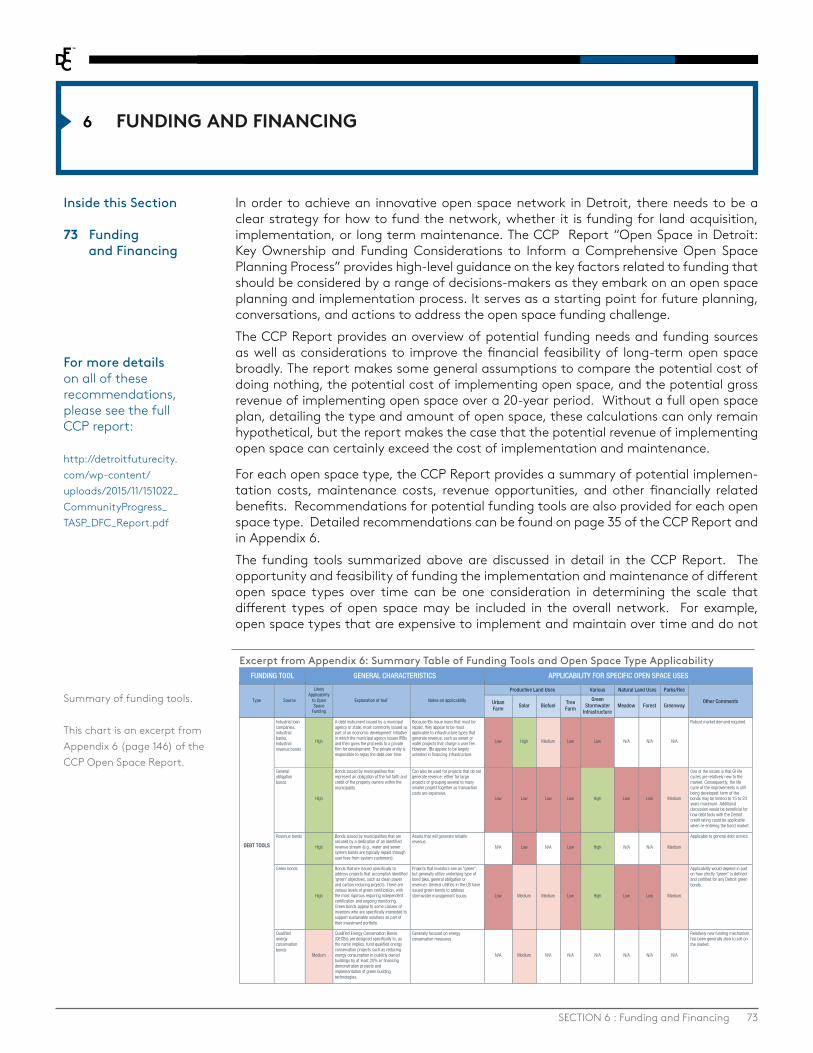
73
FUNDING AND FINANCING6
SECTION 6 : Funding and Financing
In order to achieve an innovative open space network in Detroit, there needs to be a clear strategy for how to fund the network, whether it is funding for land acquisition, implementation, or long term maintenance. The CCP Report “Open Space in Detroit: Key Ownership and Funding Considerations to Inform a Comprehensive Open Space Planning Process” provides high-level guidance on the key factors related to funding that should be considered by a range of decisions-makers as they embark on an open space planning and implementation process. It serves as a starting point for future planning, conversations, and actions to address the open space funding challenge.The CCP Report provides an overview of potential funding needs and funding sources as well as considerations to improve the financial feasibility of long-term open space broadly. The report makes some general assumptions to compare the potential cost of doing nothing, the potential cost of implementing open space, and the potential gross revenue of implementing open space over a 20-year period. Without a full open space plan, detailing the type and amount of open space, these calculations can only remain hypothetical, but the report makes the case that the potential revenue of implementing open space can certainly exceed the cost of implementation and maintenance.
For each open space type, the CCP Report provides a summary of potential implemen-tation costs, maintenance costs, revenue opportunities, and other financially related benefits. Recommendations for potential funding tools are also provided for each open space type. Detailed recommendations can be found on page 35 of the CCP Report and in Appendix 6. The funding tools summarized above are discussed in detail in the CCP Report. The opportunity and feasibility of funding the implementation and maintenance of different open space types over time can be one consideration in determining the scale that different types of open space may be included in the overall network. For example, open space types that are expensive to implement and maintain over time and do not
communityprogress.net 146
APPENDIX 6. SUMMARY TABLE: FUNDING TOOLS AND OPEN SPACE USE TYPE APPLICABILITY
FUNDING TOOL GENERAL CHARACTERISTICS APPLICABILITY FOR SPECIFIC OPEN SPACE USES
Type Source
Likely Applicability
to Open Space
Funding
Explanation of tool1 Notes on applicability
Productive Land Uses Various Natural Land Uses Parks/Rec
Other Comments Urban Farm Solar Biofuel
Tree Farm
Green Stormwater
Infrastructure Meadow Forest Greenway
DEBT TOOLS
Industrial loan companies, industrial banks, Industrial revenue bonds
High
A debt instrument issued by a municipal agency or state, most commonly issued as part of an economic development initiative in which the municipal agency issues IRBs and then gives the proceeds to a private firm for development. The private entity is responsible to repay the debt over time.
Because IBs issue loans that must be repaid, they appear to be most applicable to infrastructure types that generate revenue, such as sewer or water projects that charge a user fee. However, IBs appear to be largely untested in financing infrastructure.
Low High Medium Low Low N/A N/A N/A
Robust market demand required.
General obligation bonds
High
Bonds issued by municipalities that represent an obligation of the full faith and credit of the property owners within the municipality.
Can also be used for projects that do not generate revenue; either for large projects or grouping several to many smaller project together as transaction costs are expensive.
Low Low Low Low High Low Low Medium
One of the issues is that GI life cycles are relatively new to the market. Consequently, the life cycle of the improvements is still being developed; term of the bonds may be limited to 15 to 20 years maximum. Additional discussion would be beneficial for how debt tools with the Detroit credit rating could be applicable when re-entering the bond market.
Revenue bonds
High
Bonds issued by municipalities that are secured by a dedication of an identified revenue stream (e.g., water and sewer system bonds are typically repaid through user fees from system customers).
Assets that will generate reliable revenue.
N/A Low N/A Low High N/A N/A Medium
Applicable to general debt service.
Green bonds
High
Bonds that are issued specifically to address projects that accomplish identified 'green' objectives, such as clean power and carbon reducing projects. There are various levels of green certification, with the most rigorous requiring independent certification and ongoing monitoring. Green bonds appeal to some classes of investors who are specifically interested to support sustainable solutions as part of their investment portfolio.
Projects that investors see as "green", but generally utilize underlying type of bond (aka, general obligation or revenue). Several utilities in the US have issued green bonds to address stormwater management issues. Low Medium Medium Low High Low Low Medium
Applicability would depend in part on how strictly "green" is defined and certified for any Detroit green bonds.
Qualified energy conservation bonds
Medium
Qualified Energy Conservation Bonds (QECBs) are designed specifically to, as the name implies, fund qualified energy conservation projects such as reducing energy consumption in publicly owned buildings by at least 20% or financing demonstration projects and implementation of green building technologies.
Generally focused on energy conservation measures.
N/A Medium N/A N/A N/A N/A N/A N/A
Relatively new funding mechanism, has been generally slow to sell on the market.
Excerpt from Appendix 6: Summary Table of Funding Tools and Open Space Type Applicability
Summary of funding tools.
This chart is an excerpt from Appendix 6 (page 146) of the CCP Open Space Report.
For more details on all of these recommendations, please see the full CCP report:
http://detroitfuturecity.com/wp-content/uploads/2015/11/151022_CommunityProgress_TASP_DFC_Report.pdf
Inside this Section
73 Funding and Financing
74 DETROIT FUTURE CITY - APRIL 14, 2016
Debt Tools: · Industrial loan companies, industrial
banks, industrial revenue bonds · General obligation bonds · Revenue bonds · Green bonds · Qualified energy conservation bonds · Pooled bond financing · Private activity bonds · Certificates of participation · Revolving loan funds · Energy efficiency loans · Linked deposit programs · Property Assessed Clean
Energy (PACE) loans · Grant anticipation revenue vehicle bonds
Value Capture Mechanisms: · Developer fees and exactions
or impact fees/tap fees · Value capture · Linkage fees · Developer dedication requirements · Special districts/ improvement districts · PILOT bond · Tax increment financing · Joint development
Credit Assistance: · Credit assistance tools or loan guarantees · On-bill financing · Water infrastructure finance
and Innovation Act Program
The CCP Report provides details on the following potential funding tools and indicates applicability by open space type.
Direct Fees: · User fees and charges · Property taxes · Public benefit funds · Ground lease financing · Transfer fee fund
Equity/Private Sources: · Public-private partnership · Program-related investment (PRI) · Impact bonds/social impact bonds · Pay for success · Pooled lease-purchase · Loan loss reserve funds (LRF) · Infrastructure Investment Funds · Securitization and structured funds · Greenhouse emissions allowance auctions · Stormwater/ green stormwater
infrastructure credit trading programs · Green stromwater infrastructure bank · New market tax credits · Carbon credits · Solar investment tax credit · Individual or peer-to-peer funding
Grants: · Federal grants, · State grants, · Foundation grants
Funding Tools
have clear funding sources may need to be applied only in strategic locations, whereas open space types that are less expensive to implement and maintain or provide a clear revenue stream may have more flexibility in inclusion in the open space network. It is important to emphasize, however, that this should only be one of many considerations in determining the type, amount, and location of open space types in the network because the cheapest open space type might not achieve the overall goals of the network. For example, meadows are one of the least expensive open space types to implement and maintain, but may not achieve goals related to improving air quality or providing access to fresh, local food. Meadows can be incorporated as a part of the network because they do provide numerous benefits, but the entire network should not be made up of meadows.
Key Actions to Increase Financial FeasibilityRECOMMENDATIONS FROM THE CCP REPORTNo one single funding source nor funding tool can fully address the funding needs for open space in the city. For these reasons, Detroit must aggressively and creatively explore and employ a range of open space funding tools that will engage the public, private, and philanthropic sectors.
Investors – in the broadest sense, from the individual urban farmer to the large financial institution providing a long-term loan – will not invest their resources, whether time and/or capital, in a longer-term, larger-scale endeavor without the certainty and security provided by a clear and affirmative local planning and regulatory framework. Investors must have direction and clarity about the type of uses that will be supported by the City, at what scale, and in what areas along with a strong degree of certainty that those guidelines will be upheld in the future. Absent the supportive local planning and regu-latory framework for open space, securing the level and type of investment needed to

75SECTION 6 : Funding and Financing
The Atlanta BeltLine is a comprehensive redevelopment effort to establish an open space network consisting of trails, greenways, street car lines, ad public park space for art and other programming. The total planning area encompasses 23 square miles of the city. By 2030, the Beltline will prove 22 miles of pedestrian trails, 33 miles of multi-use trails, 1,300 acres of parks, all helping to connect 45 neighborhoods across the city.
Ownership: Atlanta Beltline, Inc (ABI) acquires land and holds land for implementation. Once developed, parkland is transferred to the City of Atlanta Parks and Recreation Department. ABI owns and maintains trailways.
Funding: The total cost of the BeltLine is estimated at $4.8 billion, with roughly $3 billion allocated to transit. A Tax Allocation District (TAD) was created to help fund a portion of the project. After a 25-year time period, the tax revenue will go back to the City, County, and Pulbic Schools. The taxable value of this area is
CASE STUDY: ATLANTA BELTLINE
communityprogress.net 127
APPENDICES
APPENDIX 1. OPEN SPACE CASE STUDY: ATLANTA, GEORGIA INTRODUCTION
Atlanta, once considered one of the nation’s most “under-parked” major cities set out to increase the amount of open green space available to its residents. In 2004, a number of studies1 were conducted to measure the feasibility of the Atlanta Beltline, a network of trails and parks
1 The studies included the Trust for Public Land’s Emerald Necklace and a financial study of the proposed Tax Allocation District commissioned by Mayor Shirley Franklin.
Figure 16: Overview Map of Atlanta BeltLine
Source: ABI
expected to increase by $20 billion because of this investment. This funding source is critical because it is used to cover general management and for required match funding for grants. Other funding sources include federal funding and private funding through the Atlants BeltLine Partnership (a privately funded non-profit organization) and the sale and lease of land.
For more information on this case study, see the CCP Report Appendix or visit http://beltline.org/.
fund open space will be impossible. The single most critical action Detroit can take to increase the financial feasibility of long-term open space is to craft and adopt a comprehensive Open Space Plan, Master Plan of Policies, and Zoning Ordinance that detail and codify permanently designated open space areas.Some of the key considerations to improve financial feasibility of implementation from the CCP report include:
· Encourage and allow for multi-functional open space. · Consider supportive uses when determining location for open space uses. · Consider the need for scaled contiguity when determining location for open space uses. · Allow for open space use flexibility, so the open space uses can shift with market conditions.
Beyond the specific land use planning considerations detailed above, the following guid-ance could be considered to improve the financial feasibility of long-term open space. Specifically:
· Support the implementation of a diverse range of pilot projects in the short term. · Invest public resources in the clearance and physical site preparation of open space uses. · Invest public resources to assemble and clear title to parcels in long-term open space areas. · Offer flexible lease and disposition terms. · Explore ways to provide flexibility in the payment of property taxes. · Encourage the creation and designation of a lead entity or position to attract or craft new,
larger-scale funding opportunities.
Investors will not invest their resources in a longer-term, larger-scale endeavor without the certainty and security provided by a clear and affirmative local planning and regulatory framework.
Policy and Legal Considerations7
Photo credit: U.S. Fish & Wildlife Service
77
POLICY AND LEGAL CONSIDERATIONS7
SECTION 7: Policy and Legal Considerations
The first step toward implementation of the open space vision is to integrate general policies for open space areas into the City of Detroit Master Plan of Policies (MPP) and designate the general location of these areas in the City’s Future General Land Use Map. While including the open space vision in the MPP is not inherently risky from a legal standpoint, how the vision is implemented through regulations could pose potential legal risk for the City. In order to reduce legal risk for the City, the Detroit Future City Im-plementation Office convened an Open Space Implementation Research Working Group in May 2014 to illustrate how the open space vision could be implemented, focusing on three areas of research: policy, regulations, and legal implications. Three task groups were formed to focus on each topic. This research and recommendations are summa-rized below.
Policy ImplementationA critical component of implementation of the open space vision is through consistent, clear policy that guides decision-making for City, State, and Federal agencies as well as philanthropic funders, private investors, and citizens. The Master Plan of Policies should be used to align policies in areas designated as Open Space in the Future General Land Use Map. The process the City uses to update the policies in the Master Plan and the Future General Land Use Map will set the framework for rezoning and establish the gov-ernmental interest being advanced. Establishing the open space vision in the Master Plan of Policies is also a critical step to reducing the legal risk for the City, because it signals to the market the intentions of the City and sets investment backed expectations for private property owners. A comprehensive update to the Master Plan and updating the Future General Land Use Map all at once will ensure that investment backed expec-tations are established all at once and will establish the ‘substantive due process’ for rezonings. The Policy Task Group proposed policies related to the following topics: · Policies for how and where redevelopment and economic growth will be targeted
(including a clear delineation on the Future General Land Use Map) · Policies for how and where vacant land will be transformed into an open space
amenity (including a clear delineation of Open Space areas on the Future General Land Use Map)
· Policies to provide incentives for residents that live in designated open space areas to move to higher density areas
· Explanation of public purpose for the open space vision in the Overview, Issue, and Goal statements of the MPP
· Updated Future General Land Use map as part of a comprehensive, one-time update to ensure that the public purpose is not singling out any group of landowners to bear the burden and to set investment backed expectations
If adopted, these proposed policies will succeed in restricting new conventional housing development in these areas by restricting the use of public funding for housing in open space areas and by restricting the disposition of publicly owned land for conventional development. Without this alignment of public policy, the open space vision cannot be realized. In addition, policies need to be included that provide incentives for residents that would like to relocate to denser, traditional residential area in order to ensure the overall success of implementation.
Inside this Section
77 Policy Implementation
78 Regulatory Implementation
79 Legal Implications
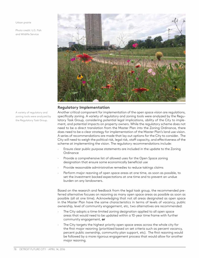
78 DETROIT FUTURE CITY - APRIL 14, 2016
Regulatory ImplementationAnother critical component for implementation of the open space vision are regulations, specifically zoning. A variety of regulatory and zoning tools were analyzed by the Regu-latory Task Group, considering potential legal implications, ability of the City to imple-ment, and potential impacts on property owners. While the regulatory scheme does not need to be a direct translation from the Master Plan into the Zoning Ordinance, there does need to be a clear strategy for implementation of the Master Plan’s land use vision. A series of recommendations are made that lay out options for the City to consider. The City will need to weigh the political risk, legal risk, staff capacity, and effectiveness of the scheme at implementing the vision. The regulatory recommendations include: · Ensure clear public purpose statements are included in the update to the Zoning
Ordinance · Provide a comprehensive list of allowed uses for the Open Space zoning
designation that ensure some economically beneficial use · Provide reasonable administrative remedies to reduce takings claims · Perform major rezoning of open space areas at one time, as soon as possible, to
set the investment backed expectations at one time and to prevent an undue burden on any landowners.
Based on the research and feedback from the legal task group, the recommended pre-ferred alternative focuses on rezoning as many open space areas as possible as soon as possible (all at one time). Acknowledging that not all areas designated as open space in the Master Plan have the same characteristics in terms of levels of vacancy, public ownership, level of community engagement, etc, two alternatives are recommended: · The City adopts a time-limited zoning designation applied to all open space
areas that would need to be updated within a 10-year time frame with further community engagement, or
· The City targets the highest priority open space areas across the whole city for the first major rezoning (prioritized based on set criteria such as percent vacancy, percent public ownership, community plan support, etc). The first rezoning would be followed by a more rigorous engagement process that would allow for another major rezoning.
A variety of regulatory and zoning tools were analyzed by the Regulatory Task Group.
Urban prairie
Photo credit: U.S. Fish and Wildlife Service
79SECTION 7: Policy and legal Considerations
Legal ImplicationsIn order to implement the open space vision, the City needs to consider and weigh po-tential legal risk with regulatory actions taken, specifically related to rezoning formerly residential or commercial land to an open space designation in the City’s Zoning Ordi-nance, including the Zoning Map. P&DD expressed concern about the legal risk associ-ated with these actions, especially related to the issue of a potential Regulatory or De Facto Taking that may result from designating areas as open space.
The Legal Task Group performed case law research and provided legal opinions based on the regulatory schemes presented by the Regulatory Task Group. The Regulatory Task Group has adjusted and updated the regulatory scheme based on the feedback of the Legal Task Group in order to reduce legal risk as much as possible for the City of Detroit, with the understanding that legal risk can never be fully eliminated, but only minimized. The Legal Task Group specifically researched whether rezoning land in the City of Detroit from residential or commercial to an Open Space zoning category would be so confis-catory as to violate substantive due process or amount to a taking. A summary of the findings of the legal task group follows:
SUBSTANTIVE DUE PROCESSThe City will need to show that the regulation advances the governmental interest in a reasonable way. Clear public purpose statements are needed to show the substantial relation to public health, safety, and welfare. Having a strong Master Plan of Policies that establishes the City’s vision for transforming blighted, vacant property into an open space amenity, provides policies, and designates lands to implement that vision will help strengthen the rationale for Open Space zoning.
REGULATORY TAKINGBased on the Penn Central Case, there are three factors that must be considered for the balancing test: · Not an Undue Burden to any Landowners
It is critical that the City can show that the Open Space designation in the Master Plan and Zoning is applied to many landowners and does not single out any owners to shoulder a burden that should be carried by everyone.
· Economically Beneficial Use If a rezoning to Open Space still allows for some economically productive uses, then the rezoning will not deprive the land of all economically beneficial uses. The land value is not the land’s productivity, but the land’s sale value. Therefore, there needs to be a market for the allowed uses (and the potential purchaser can’t just be a governmental entity).
· Investment-Backed Expectations If the landowners have not made residential improvements to the property, the court may be less likely to find that the rezoning interferes with the landowner’s investment-backed expectations. To argue a vested interest in keeping the property zoned residential, the owner must be actively investing in a particular use of the property. In addition, the court will consider the land’s historical use and the nature and use of the surrounding land. The City can argue that circumstances (real estate market, property values, etc) have changed so drastically in Detroit that even though the land is zoned residential, the landowner’s expectation for their investments could not properly extend to residential use. Land owners who purchase land after the land is zoned to Open Space can no longer argue they purchased the land with residential expectations.
In order to transform Detroit’s vacant land liability into an open space amenity, the City needs a clear open space implementation strategy. The policies, regulatory scheme, and legal research compiled in this report provide the City with a clear path toward implementation of the open space vision. These recommendations provide the City with flexibility to choose options that work best, while providing information on potential legal risk and other considerations.
The Legal Task Group specifically researched whether rezoning land in the City of Detroit from residential or commercial to an Open Space zoning category would be so confiscatory as to violate substantive due process or amount to a taking.

Conclusion8
Photo credit: University of Michigan

81
CONCLUSION8
SECTION 8: Conclusion
This report lays the groundwork for achieving an integrated open space network in De-troit in order to improve quality of life for all Detroiters. The report makes a clear case for the economic, social, and environmental benefits that will come from transforming Detroit’s vacant land liability into an open space amenity.
This report can be used as a platform to inform city-wide open space planning, com-munity level open space planning, as well as open space implementation projects at all scales. It can also be used as an advocacy tool with elected officials and community leaders and as a resource to support grant applications and conversations with funders to support on-the-ground implementation.
The open space network will not be achieved without action. The following actions must be taken in order to achieve an integrated open space network in Detroit: · Create an open space plan with robust community engagement · Integrate the open space vision into the Master Plan of Policies and Zoning to enable
implementation over time · Incorporate all types of open space into the network in a balanced way to achieve the
community’s overall goals and objectives based on the community’s values · Create clear policies and procedures to provide access to publicly owned land to
individuals and groups that are working to achieve the vision laid out in the open space plan
· Pursue appropriate ownership models and funding techniques that will best aid in the creation of the open space network over time
· Work to aggregate and consolidate vacant land to facilitate the creation of open space · Support pilot projects that test new ideas and work to integrate these pilot projects
into the larger open space network · Continue to support people and projects that are already working to implement vacant
land transformation
Detroit Future City will continue to work with our partners, open space stakeholders, elected officials, and Detroit residents to achieve an open space network. We will con-tinue to advocate for a comprehensive open space planning process and we will provide technical assistance to pilot projects and planning initiatives whenever possible.
No one organization or agency can do this on their own. We must all work togeth-er to create and achieve the vision for open space in Detroit. A coordinated advocacy campaign is needed across a wide variety of organizations to educate and inspire the public and elected officials on the benefits of an integrated open space network and to advocate for citywide policy and regulatory reform that enables and supports the work of a range of groups, from citywide organizations implementing large scale projects to residents greening individual lots. Our collective action will improve quality of life for all Detroiters and create an open space legacy for generations to come, creating a green and sustainable city unlike any other in the world.
What can you do to achieve an open space network? · Advocate for the creation an open space plan (with your District Manager, City
Council member, Mayor’s Office) · Work with your community (residents, block clubs, neighborhood associations, cdcs,
business associations) to create a plan for open space in your community · Transform a vacant lot in your neighborhood
Inside this Section
81 Conclusion

End Notes
83ENDNOTES
END NOTES 1. U.S. Census Bureau
2. Detroit Alliance for Asthma Awareness
3. Michigan Department of Community Health
4. Urban green space, public health, and environmental justice: The challenge of making cities ‘just green enough’ Jennifer R. Wolcha, , ,Jason Byrneb, Joshua P. Newellc, Landscape and Urban Planning Volume 125, May 2014, Pages 234–244 http://www.sciencedirect.com/science/article/pii/S0169204614000310 Public Health Impacts of Old Coal-Fired Power Plants in Michigan - http://environmentalcouncil.org/mecReports/PublicHealthImpactsofOldCoal-FiredPowerPlantsinMichigan.pdf
5. http://www.freep.com/story/news/local/michigan/2015/08/03/obama-clean-power-plan-carbon-climate-change-energy/31083425/
6. Public Health Impacts of Old Coal-Fired Power Plants in Michigan - http://environmentalcouncil.org/mecReports/PublicHealthImpactsofOldCoal-FiredPowerPlantsinMichigan.pdf
7. Mitchel, Rand Popham
8. Detroit Food System 2009-10 Report. Prepared by Kami Pothukuchi, Ph.D., Wayne State University For the Detroit Food Policy Council May 15, 2011; Psychological benefits of greenspace increase with biodiversity. Richard A Fuller, Katherine N Irvine, Patrick Devine-Wright, Philip H Warren, Kevin J Gaston Published 22 August 2007.DOI: 10.1098/rsbl.2007.0149; Ulrich, Kim, and Cervinka show that time in nature or scenes of nature are associated with a positive mood, and psychological wellbeing, meaningfulness, and vitality.; Ulrich, R. S. (1984). View through a window may influence recovery from surgery. Science, 224(4647), 420-421.; Cervinka, R., Röderer, K., & Hefler, E. (2012). Are nature lovers happy? On various indicators of well-being and connectedness with nature. Journal of Health Psychology, 17(3), 379-388.
9. Creating sense of community: The role of public space. Journal of Environmental Psychology Volume 32, Issue 4, December 2012, Pages 401–409, Jacinta Francis Billie Giles-Corti1, Lisa Wood Matthew Knuiman; Coley, R., Kuo, F. E., & Sullivan, W. C. (1997). Where does community grow? The social context created by nature in urban public housing. Environment and Behavior, 29(4), 468.; http://www.takingcharge.csh.umn.edu/enhance-your-wellbeing/environment/nature-and-us/how-does-nature-impact-our-wellbeing
10. The Economic Benefits of Parks and Open Space. Trust for Public Land. https://www.tpl.org/sites/default/files/cloud.tpl.org/pubs/benfits_EconBenef_Parks_OpenSpaceL.pdf
11. SEEING GREEN Green Infrastructure Maintenance Training and Workforce Development Opportunities in Northeast Ohio. Green For All, LAND Studio, and The Center for Economic Development of the Maxine Goodman Levin College of Urban Affairs at Cleveland State University. http://savetherain.us/wp-content/uploads/2011/10/GreenForAll_seeing_green_08-2013.pdf

84 DETROIT FUTURE CITY - APRIL 14, 2016
12. The Economic Value of Parks. Open Space San Francisco. http://www.openspacesf.org/node/39?phpMyAdmin=B3a%2C-cbmDK07AdsMpUGthHU0xfa]
13. Economic Analysis of Detroit Food System
14. The Economic Benefits of Open Space. The Trust for Public Land 1999
15. Fact Sheet: Continuing to Drive Growth in Solar Energy Across the Country. The White House. https://www.whitehouse.gov/the-press-office/2015/09/16/fact-sheet-continuing-drive-growth-solar-energy-across-country
16. President Barack Obama’s State of the Union Address. January 28, 2014. The White House. https://www.whitehouse.gov/the-press-office/2014/01/28/president-barack-obamas-state-union-address
17. Air pollution removal by urban trees and shrubs in the United States. Nowak et al., 2006. D.J. Nowak, D.E. Crane, J.C. Stevens. Urban Forestry and Urban Greening, 4 (2006), pp. 115–123]
18. The Potential Impacts of Climate Change on Detroit, MI. Great Lakes Integrated Sciences and Assessments in partnership with the Detroit Climate Action Collaborative. http://www.dwej.org/wp-content/uploads/2012/06/DCAC-Climate-Impacts-One-Pager.pdf
19. Cool Surfaces and Shade Trees to Reduce Energy Use and Improve Air Quality in Urban Areas. Solar Energy Vol. 70, No. 3, pp. 295–310, 2001. Akbari et al, 2001. http://www.coolrooftoolkit.org/wp-content/uploads/2012/04/20120127190624231.pdf
20. Chicago’s urban forest ecosystem: Results of the Chicago Urban Forest Climate Project. McPherson, E. Gregory; Nowak, David J.; Rowntree, Rowan A. eds. 1994. Gen. Tech. Rep. NE-186. Radnor, PA: U.S. Department of Agriculture, Forest Service, Northeastern Forest Experiment Station: 201 p http://www.nrs.fs.fed.us/pubs/gtr/gtr_ne186.pdf
21. Chicago Metropolitan Agency for Planning - http://www.cmap.illinois.gov/about/2040/supporting-materials/process-archive/strategy-papers/parks-and-open-lands/environmental-benefits; http://www.cmap.illinois.gov/documents/10180/58240/ParksWhitePaper.pdf/ad268264-545d-4e55-8e94-305a698df62a
22. Cities Impacts and Climate Adaptation Tool, University of Michigan Graham Center for Sustainability
23. Chicago Metropolitan Agency for Planning - http://www.cmap.illinois.gov/about/2040/supporting-materials/process-archive/strategy-papers/parks-and-open-lands/environmental-benefits
24. International Association for Great Lakes Research http://iaglr.org/scipolicy/issues/detroithabitat.php
25. City of Detroit, Draft Planning Report p106. 1983
26. Detroit Future City http://detroitfuturecity.com/framework/
85ENDNOTES
27. Motor City Mapping https://www.motorcitymapping.org
28. City of Detroit Open Data Portal https://data.detroitmi.gov/
29. Detroit Blight Removal Task Force http://report.timetoendblight.org/
30. Detroit Greenways Coalition http://detroitgreenways.org/history/
31. SEMCOG Green Infrastructure Vision http://semcog.org/Reports/GIVision/index.html#3/z
32. Detroit Water and Sewerage Department: Green Infrastructure http://www.dwsd.org/pages_n/green_infrastructure.html
33. Creating a Food Secure Detroit. Detroit Food Policy Council. http://detroitfoodpolicycouncil.net/sites/default/files/pdfs/Detroit_Food_Security_Policy.pdf
34. The Detroit Food System Report 2009-2010. Detroit Food Policy Council. http://detroitfoodpolicycouncil.net/sites/default/files/pdfs/DFPC%20Food%20Report%20Complete%20Version.pdf
35. Economic Analysis of Detroit’s Food System. Detroit Food & Fitness Collaborative http://d3n8a8pro7vhmx.cloudfront.net/gleaners/legacy_url/226/DETROIT_book_r6_8_29_14_lowres.pdf_docID_9962?1443223248
36. International Association for Great Lakes Research http://iaglr.org/scipolicy/issues/detroithabitat.php
37. Convention on biological diversity, 2002, p4. https://www.cbd.int/2010/about/
38. Semcog Green Infrastructure Vision. http://semcog.org/Reports/GIVision/index.html#3/z
39. Baltimore Green Space - Baltimore’s Forest Patches http://baltimoregreenspace.org/wp-content/uploads/2014/08/ForestPatchesWeb.pdf
40. Biodiversity Atlas of the Lake Huron to Lake Erie Corridor. http://www.fws.gov/uploadedFiles/Along_the_Shoreline.pdf
41. Managing Michigan’s Wildlife: A Landowner’s Guide http://www.michigandnr.com/publications/pdfs/huntingwildlifehabitat/landowners_guide/habitat_mgmt/Grassland/Prairie_Restorations.htm
42. Taken from the EPA Regulations listed at 40 CFR 230.3(t)
43. Wetland Utilization and Protection in China. Zhao, Q.G, and Song, J. (eds) 2004. http://www.sopa.nsw.gov.au/__data/assets/pdf_file/0003/804522/1.01_The_importance_of_urban_wetlands.pdf
86 DETROIT FUTURE CITY - APRIL 14, 2016
44. Michigan Department of Natural Resources http://www.michigan.gov/dnr/0,4570,7-153-10370_22664-61132--,00.html
45. Michigan Department of Environmental Quality http://www.michigan.gov/deq/0,4561,7-135-3313_3687-11177--,00.html
46. International Association for Great Lakes Research http://iaglr.org/scipolicy/issues/detroithabitat.php
47. Ibid.
48. Chicago Metropolitan Agency for Planning http://www.cmap.illinois.gov/about/2040/supporting-materials/process-archive/strategy-papers/parks-and-open-lands/environmental-benefits
49. River Rouge Advisory Council http://www.allianceofrougecommunities.com/rrac.html Bloody Run Creek Greenway Redevelopment Plan https://issuu.com/dcdc-udm/docs/bloodyrun
50. SEMCOG Green Infrastructure Vision http://semcog.org/Reports/GIVision/index.html#3/z
51. EPA Green Infrastructure http://water.epa.gov/infrastructure/greeninfrastructure/gi_what.cfm
52. EPA Great Lakes http://www.great-lakes.net/lakes/ref/lakefact.html http://www2.epa.gov/nutrient-policy-data/great-lakes
53. DEQ. http://www.deq.state.mi.us/csosso/find_event.asp
54. Detroit Water and Sewerage Department - Green Infrastructute Plan for the Upper Rouge Tunnel Area http://www.dwsd.org/downloads_n/about_dwsd/npdes/dwsd_gi_upper_rouge_tunnel_area_08-01-2014.pdf
55. Economic Analysis of Detroit’s Food System. Detroit Food & Fitness Collaborative. http://d3n8a8pro7vhmx.cloudfront.net/gleaners/legacy_url/226/DETROIT_book_r6_8_29_14_lowres.pdf_docID_9962?1443223248
56. City of Detroit Urban Agriculture Ordinance. http://detroitagriculture.net/wp-content/uploads/2013_Sharable_UA-Ordinance.pdf
57. A City of Detroit Policy on Food Security “Creating a Food Secure Detroit” http://detroitblackfoodsecurity.org/policy.html
58. Detroit Food System 2009-10 Report. Prepared by Kami Pothukuchi, Ph.D., Wayne State University For the Detroit Food Policy Council May 15, 2011
50.
87ENDNOTES
59. Growing Food In the City: The Production Potential of Detroit’s Vacant Land. June 2010. Colasanti, Litjens, Hamm. http://foodsystems.msu.edu/uploads/files/Growing_Food_in_the_City_-_Colasanti_Litjens_Hamm.pdf
60. National Renewable Energy Laboratory
61. U.S. Energy Information Administration
62. USEPA Criteria Air Pollutants in Southeast Michigan
63. Interstate Renewable Energy Council, The Solar Foundation, Meister Consultants Group
64. Center for Community Progress Report: Open Space in Detroit: Key Ownership and Funding Considerations to Inform a Comprehensive Open Space Planning Process. http://detroitfuturecity.com/wp-content/uploads/2015/11/151022_CommunityProgress_TASP_DFC_Report.pdf
65. Trust for Public Land: Parkscore http://parkscore.tpl.org/
66. Detroit Greenways Collation http://detroitgreenways.org/blog/wp-content/uploads/2015/02/MAP-Non-Motorized-Transportion-single-citymap-08-12-2015-Model_1.pdf
67. http://www.nbcnews.com/news/us-news/motor-city-bike-city-inside-detroits-bicycle-renaissance-n467316
68. http://www3.epa.gov/otaq/documents/nearroadway/420f14044.pdf
69. Baldauf, Richard, et al. Integrating Vegetation and Green Infrastructure into Sustainable Transportation Planning. 2013 http://www.fs.fed.us/psw/publications/mcpherson/psw_2013_mcpherson006_baldauf.pdf