Accuracy Assessment of Bundle Adjustment with UAV-based ... · Accuracy Assessment of Bundle...
13
Accuracy Assessment of Bundle Adjustment with UAV Based on Images of Tropical Forest Using Sparse Control (7664) Adilson Berveglieri, Raquel Oliveira, Alexandre Mainardi and Antonio Tommaselli (Brazil) FIG Working Week 2015 From the Wisdom of the Ages to the Challenges of the Modern World Sofia, Bulgaria, 17-21 May 2015 1/13 Accuracy Assessment of Bundle Adjustment with UAV-based Images of Tropical Forest Using Sparse Control Adilson BERVEGLIERI, Raquel OLIVEIRA, Antonio TOMMASELLI, Alexandre MAINARDI and Ricardo AFFONSO, Brazil Keywords: DSM, Orientation, Triangulation, Vegetation SUMMARY This work aims at performing a preliminary study on the image orientation and digital surface model (DSM) generation for forest areas using images acquired with an unmanned aerial vehicle (UAV). The coordinates of the camera perspective centres (PCs) are directly determined by a dual frequency receiver and the camera is stabilized with an active gimballed platform. A flight survey with an UAV was carried out to acquire 67 images in two flight strips over a tropical forest area. GCPs (pre-marked targets) were only surveyed at the end of the flight strips to be used in the proposed technique. Tie points were automatically determined and checked manually, and bundle adjustments (BAs) were performed with weighted constraints in PC positions and in GCPs. A DSM was also produced to check the resulting point clouds. A few checkpoints, available inside of the forest, were introduced into the BA to assess the technique. Then, the analysis of results was performed on the discrepancies obtained at checkpoints. The experiments showed that the discrepancies were compatible with the expected accuracy around 20 cm in the object space, and the generated DSM can be used to estimate canopy height.
-
Upload
phungduong -
Category
Documents
-
view
367 -
download
0
Transcript of Accuracy Assessment of Bundle Adjustment with UAV-based ... · Accuracy Assessment of Bundle...

Accuracy Assessment of Bundle Adjustment with UAV Based on Images of Tropical Forest Using Sparse Control (7664) Adilson Berveglieri, Raquel Oliveira, Alexandre Mainardi and Antonio Tommaselli (Brazil) FIG Working Week 2015 From the Wisdom of the Ages to the Challenges of the Modern World Sofia, Bulgaria, 17-21 May 2015
1/13
Accuracy Assessment of Bundle Adjustment with UAV-based Images of Tropical Forest Using Sparse Control
Adilson BERVEGLIERI, Raquel OLIVEIRA, Antonio TOMMASELLI,
Alexandre MAINARDI and Ricardo AFFONSO, Brazil Keywords: DSM, Orientation, Triangulation, Vegetation SUMMARY This work aims at performing a preliminary study on the image orientation and digital surface model (DSM) generation for forest areas using images acquired with an unmanned aerial vehicle (UAV). The coordinates of the camera perspective centres (PCs) are directly determined by a dual frequency receiver and the camera is stabilized with an active gimballed platform. A flight survey with an UAV was carried out to acquire 67 images in two flight strips over a tropical forest area. GCPs (pre-marked targets) were only surveyed at the end of the flight strips to be used in the proposed technique. Tie points were automatically determined and checked manually, and bundle adjustments (BAs) were performed with weighted constraints in PC positions and in GCPs. A DSM was also produced to check the resulting point clouds. A few checkpoints, available inside of the forest, were introduced into the BA to assess the technique. Then, the analysis of results was performed on the discrepancies obtained at checkpoints. The experiments showed that the discrepancies were compatible with the expected accuracy around 20 cm in the object space, and the generated DSM can be used to estimate canopy height.

Accuracy Assessment of Bundle Adjustment with UAV Based on Images of Tropical Forest Using Sparse Control (7664) Adilson Berveglieri, Raquel Oliveira, Alexandre Mainardi and Antonio Tommaselli (Brazil) FIG Working Week 2015 From the Wisdom of the Ages to the Challenges of the Modern World Sofia, Bulgaria, 17-21 May 2015
2/13
Accuracy Assessment of Bundle Adjustment with UAV-based Images of Tropical Forest Using Sparse Control
Adilson BERVEGLIERI, Raquel OLIVEIRA, Antonio TOMMASELLI,
Alexandre MAINARDI and Ricardo AFFONSO, Brazil
1. INTRODUCTION The conservation and recovery of native forests are global needs widely recognized and these tasks require updated maps. Although mapping techniques have significantly evolved, there is a need for high temporal update frequency for environmental monitoring. Aerial and orbital imagery can be used for large areas but the spatial resolution is limited and these techniques are not cost effective for small areas. However, for smaller areas as remaining forest fragments, the use of images collected by unmanned aerial vehicle (UAV) is feasible due to the lower costs and the feasibility of image acquisition with suitable spatial and temporal frequency. Remondino et al. (2011) presented an overview on UAV systems emphasizing photogrammetric applications. The author highlighted the ability to quickly deliver high temporal and spatial resolution image information. Eisenbeiss (2011) also performed a study on the potential of various UAV systems using a categorization of photogrammetric data acquisition platforms with respect to mapping tasks. Despite the stability and endurance of UAV platforms still need to be improved, UAV photogrammetry can provide accurate data depending on the requirements. This enables the use of UAVs in inaccessible areas, e.g. forests. Typically tropical forests have dense vegetation areas being difficult to set ground control. In addition, vegetation characteristics complicate image matching due to repetitive textures, multi-layered or moving objects (Lisein et al., 2013). However, St-Onge et al. (2008) commenting on these problems, argued that they can be at least partially solved and a canopy surface model can be produced by image matching with acceptable accuracy and resolution. According to Lisein et al. (2013), canopy height measurements are important for forest monitoring and estimation of biomass and carbon stock. Furthermore, structural forest attributes can be obtained from the canopy height model that in combination with field measurements can be used for the prediction of forest attributes, such as stand density and maturity indicators. This work performs a preliminary study on the UAV image orientation of two image strips aiming at digital surface model (DSM) generation of tropical forest areas using an unconventional sparse control. The study investigates the automatic tie point determination over forest images and also the accuracy resulting from bundle adjustment (BA) using UAV image strips for DSM generation. Because GCPs can be located only outside the forests, it is relevant to assess the resulting effects.

Accuracy Assessment of Bundle Adjustment with UAV Based on Images of Tropical Forest Using Sparse Control (7664) Adilson Berveglieri, Raquel Oliveira, Alexandre Mainardi and Antonio Tommaselli (Brazil) FIG Working Week 2015 From the Wisdom of the Ages to the Challenges of the Modern World Sofia, Bulgaria, 17-21 May 2015
3/13
Experiments with BA were performed to orientate the UAV images and to produce a DSM in a test area. Two checkpoints, available inside the forest, were also introduced into the BA for accuracy assessment. The results analysis was performed based on the discrepancies obtained from the checkpoints. In the following sections, the methodology and results will be presented and discussed, as well as the advantages and drawbacks of the proposed technique. 2. BUNDLE ADJUSTMENT USING SPARSE CONTROL FOR DSM GENERATION The methodology to produce a DSM in tropical forest using sparse control was organized with the following steps: camera calibration; pre-marked target positioning and flying survey; image orientation; and DSM generation. 2.1 Camera calibration The camera calibration procedure is needed because accurate data are required. Usually focal length, principal point coordinates and symmetric radial and decentring distortions coefficients are the interior orientation parameters (IOPs) to be determined. In this project, this task was performed in a terrestrial calibration field. The mathematical model is commonly based on the collinearity equations (Kraus, 2007) with addition of parameters of the Conrady-Brown model (Fryer and Brown, 1986). The resulting equations system can be solved by the least squares method considering some constraints imposed to the ground coordinates and observations on the exterior orientation parameters (EOPs). 2.2 Pre-marked target positioning and flying survey Ground control is needed to ensure and to assess the geometric quality of the camera EOPs and to compute photogrammetric point coordinates. Typically, forest areas are inaccessible and suitable areas to set control points are not available. Thus, a few pre-marked targets are used as a control outside the forest area, which can be easily installed before the flying survey. The targets are only positioned at the ends of each flying strip in the external side of the forest. The aerial survey is planned to acquire images for forest sampling. During the surveying, the coordinates of the camera perspective centres (PCs) are directly determined with a dual frequency receiver and the camera is stabilized with a gimbal. Although the attitude angles are not provided, accurate Global Navigation Satellite System (GNSS) data are obtained for the camera position. The initial attitude angles are based on the flight plan. 2.3 Image orientation Image frames and strips have to be connected with tie points to enable the UAV image triangulation using a minimum of GCPs and PC coordinates. However, the vegetation canopy
Accuracy Assessment of Bundle Adjustment with UAV Based on Images of Tropical Forest Using Sparse Control (7664) Adilson Berveglieri, Raquel Oliveira, Alexandre Mainardi and Antonio Tommaselli (Brazil) FIG Working Week 2015 From the Wisdom of the Ages to the Challenges of the Modern World Sofia, Bulgaria, 17-21 May 2015
4/13
is sometimes homogeneous, making troublesome tie point generation and transfer, requiring further supervision by an operator. The dual frequency GNSS system installed on board UAV allows the acquisition of PC positions during the flight. These positions are used either as initial approximations or as weighted constraints in the BA and the attitude angles are considered as unknowns. The pre-marked targets are used as GCPs considering the accuracy resulting from the GNSS positioning. 2.4 DSM generation DSMs contain information about the object heights as buildings, trees, etc. The automatic DSM generation is based on image matching techniques using two or more images simultaneously, and several approaches have been suggested for such purpose. In general, the algorithms encompass multi-image matching (e.g., Zhu et al., 2010) based on semi-global matching (Hirschmüller, 2008), patch-based methods (Furukawa and Ponce, 2010) or optimal flow techniques (Pierrot-Deseilligny and Paparoditis, 2006). For this study, the DSM is used to represent the vegetation canopy of tropical forests, and only tie points are defined as seed points to generate a DSM. If a Digital Terrestrial Model (DTM) from the interest area is available, tree heights can be obtained by calculating the difference between both DSM and DTM. For assessment, the quality of a DSM can be verified on the discrepancies calculated from checkpoints. 3. EXPERIMENTS AND ANALISYS OF RESULTS
An aerial survey was conducted to collect images with an UAV platform over a tropical forest area using the proposed technique. The procedures used to perform the trials are explained in the following sections.
3.1 Camera calibration procedure A Sony Nex-7 digital camera with a Voigtländer lens was used for image acquisition. The details about this camera are presented in Table 1. Table 1. Technical details on the digital camera used to acquire aerial images. Camera model Sony Nex-7 Image dimensions 6000 × 4000 pixels Pixel size 0.0039 mm Nominal focal length 21.0 mm (Voigtländer) The camera calibration procedure was performed in a 3D terrestrial calibration field, which is composed of targets coded with Aruco format (Garrido-Jurado et al., 2014), as shown in Figure 1. A software, adapted by Silva et al. (2014), was used for the automatic detection and

Accuracy Assessment of Bundle Adjustment with UAV Based on Images of Tropical Forest Using Sparse Control (7664) Adilson Berveglieri, Raquel Oliveira, Alexandre Mainardi and Antonio Tommaselli (Brazil) FIG Working Week 2015 From the Wisdom of the Ages to the Challenges of the Modern World Sofia, Bulgaria, 17-21 May 2015
5/13
recognition of these targets in the images, which also enabled to identify the ground coordinates of each target corner with its respective object coordinate.
Figure 1. Terrestrial calibration field composed of Aruco coded targets.
The IOPs were determined using the Calibration Multi-Camera (CMC) software, developed by Ruy et al. (2009). Table 2 presents the IOPs after calibration.
Table 2. IOPs estimated by the camera calibration procedure. Parameter Estimated value Standard deviation f (mm) 21.4351 0.0009 (± 0.23 pixels) x0 (mm) -0.0790 0.0008 (± 0.21 pixels) y0 (mm) 0.0232 0.0008 (± 0.22 pixels) K1 (mm-2) -1.13×10⁻⁴ 8.7×10⁻⁷ K2 (mm-4) -2.94×10⁻⁸ 1.82×10⁻⁸ K3 (mm-6) 7.39×10⁻¹⁰ 1.02×10⁻¹⁰ P1 (mm-1) 2.18×10⁻⁵ 7.86×10⁻⁷ P2 (mm-1) -3.44×10⁻⁶ 7.82×10⁻⁷ σ naught 0.81 (a-priori σ = 1)
3.2 Data acquisition system An UAV hexacopter multi-rotor, mounted by the Nuven.in and Sensormap Companies, was equipped with a camera and a dual frequency GNSS receiver on board to acquire images (see Figure 2). Camera triggering and event recording was performed with an on-board system which is a light version of an existing aerial acquisition system (SAAPI, Ruy et al., 2009). Originally SAAPI system was concept for direct georeferencing and designed to use up to three airborne cameras simultaneously in different configurations. To collect UAV images, this system was simplified to have less payload weight. Only the GNSS positions were acquired with a dual frequency receiver as well as the time stamps of camera events. Attitude data were not

Accuracy Assessment of Bundle Adjustment with UAV Based on Images of Tropical Forest Using Sparse Control (7664) Adilson Berveglieri, Raquel Oliveira, Alexandre Mainardi and Antonio Tommaselli (Brazil) FIG Working Week 2015 From the Wisdom of the Ages to the Challenges of the Modern World Sofia, Bulgaria, 17-21 May 2015
6/13
available, but the camera was stabilized with a gimballed platform maintaining low tilting angles.
Figure 2. Hexacopter used to acquire the tropical forest images.
3.3 Experiments in a test area for DSM generation The test area used for the experiments is located in Teodoro Sampaio/São Paulo – Brazil. It is an area with native trees forming a dense tropical forest, as shown in Figure 3, and it is part of a Federal Protected Reserve, named Estação Ecológica Mico Leão Preto. This region is protected by environmental laws and requires monitoring to guarantee the preservation of both vegetation and animals. Figure 3 also shows the exposure stations forming two strips (forward and backward) flown with an UAV to collect images from the take-off site until the sample area selected (yellow polygon), far 600 m from the GCPs.
Figure 3. Test area showing the two flight strips with 67 images (camera exposure stations) collected by an UAV over a tropical forest. The yellow polygon indicates the sample area selected to generate the DSM.

Accuracy Assessment of Bundle Adjustment with UAV Based on Images of Tropical Forest Using Sparse Control (7664) Adilson Berveglieri, Raquel Oliveira, Alexandre Mainardi and Antonio Tommaselli (Brazil) FIG Working Week 2015 From the Wisdom of the Ages to the Challenges of the Modern World Sofia, Bulgaria, 17-21 May 2015
7/13
Before carrying out the aerial survey, two pre-marked targets were installed out of the forest to be used as GCPs. Next, the flying survey was performed with the UAV at a flying height of 150 m, acquiring two strips composed of 67 images with a GSD of 3 cm. Two clearings existing in the test area were used to collect two checkpoints with GNSS receiver. Due to the lack of distinguishable features within the clearings, both checkpoints were only used to assess the altimetry. Figure 4(a) depicts the flying strip geometry with the two GCPs on a side of the strip ends and two checkpoints on the opposite side.
Figure 4. Geometry of the two flight strips with 67 images, two GCPs and two checkpoints in
(a), and automatic generated tie points in (b). The image orientation was performed in a photogrammetric project configured in the ERDAS-LPS (Leica Photogrammetric Suite) as follows: EOPs: initial values for camera position (X0, Y0, Z0) were based on the raw data collected
by an on-board GNSS receiver during the aerial survey. Five experiments were performed varying the weighted constraints in the PC coordinates, based on the standard deviations from σposition = 10 to 50 cm. The attitude angles were considered as unknowns;
IOPs were based on the values estimated in the terrestrial calibration trial; Image coordinates were set with a standard deviation of σ = 0.5 pixel; GCP coordinates with a standard deviation of σ = 5 cm; Tie points were automatically generated using 25 points per model and checked manually – outcome in Figure 4(b). The geometric robustness, provided by the tie points, also enabled to perform a BA processing without GCPs for assessment and comparison purposes. Thus, several BAs (with and without GCPs) were calculated to determine the EOPs of the UAV images, and all results will be presented in section 4.4.
Accuracy Assessment of Bundle Adjustment with UAV Based on Images of Tropical Forest Using Sparse Control (7664) Adilson Berveglieri, Raquel Oliveira, Alexandre Mainardi and Antonio Tommaselli (Brazil) FIG Working Week 2015 From the Wisdom of the Ages to the Challenges of the Modern World Sofia, Bulgaria, 17-21 May 2015
8/13
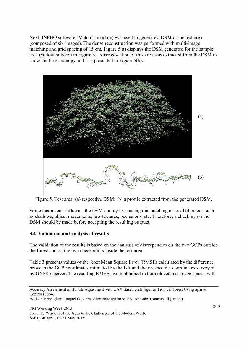
Next, INPHO software (Match-T module) was used to generate a DSM of the test area (composed of six images). The dense reconstruction was performed with multi-image matching and grid spacing of 15 cm. Figure 5(a) displays the DSM generated for the sample area (yellow polygon in Figure 3). A cross section of this area was extracted from the DSM to show the forest canopy and it is presented in Figure 5(b).
(a)
(b)
Figure 5. Test area: (a) respective DSM; (b) a profile extracted from the generated DSM. Some factors can influence the DSM quality by causing mismatching or local blunders, such as shadows, object movements, low textures, occlusions, etc. Therefore, a checking on the DSM should be made before accepting the resulting outputs. 3.4 Validation and analysis of results The validation of the results is based on the analysis of discrepancies on the two GCPs outside the forest and on the two checkpoints inside the test area. Table 3 presents values of the Root Mean Square Error (RMSE) calculated by the difference between the GCP coordinates estimated by the BA and their respective coordinates surveyed by GNSS receiver. The resulting RMSEs were obtained in both object and image spaces with

Accuracy Assessment of Bundle Adjustment with UAV Based on Images of Tropical Forest Using Sparse Control (7664) Adilson Berveglieri, Raquel Oliveira, Alexandre Mainardi and Antonio Tommaselli (Brazil) FIG Working Week 2015 From the Wisdom of the Ages to the Challenges of the Modern World Sofia, Bulgaria, 17-21 May 2015
9/13
five weighted constrains in the camera PC position, being the attitude considered as unknowns in all trials. Table 3. RMSE obtained from two GCPs in both object and image spaces considering five weighted constraints for the camera PC position. GCP Coordinate
σposition =10 cm σposition = 20 cm σposition = 30 cm σposition = 40 cm σposition = 50 cm
RMSE (m) RMSE (m) RMSE (m) RMSE (m) RMSE (m) Ground X 0.004 0.003 0.002 0.001 0.001 Ground Y 0.121 0.065 0.041 0.031 0.028 Ground Z 0.033 0.023 0.015 0.010 0.009 (pixel) (pixel) (pixel) (pixel) (pixel) Image x 0.47 0.35 0.28 0.24 0.22 Image y 0.31 0.21 0.17 0.16 0.16
By reducing the weigthed constraints imposed to σposition, the RMSEs ranged: from 4 to 1 mm in ground X; from 12.1 to 2.8 cm in ground Y, and from 3.3 to 0.9 cm in ground Z. Consequently, these values indicated more precision in X (fligth direction) in comparison with Y. In the image space, both x and y coordinates were below 0.5 pixel. Figure 6 presents results of BAs performed with the two groups (with and without GCPs) considering five different weights values for the constraints imposed to the camera PC coordinates. The resulting graph shows the RMSEs in Z coordinate obtained from two checkpoints to verify the accuracy in the test area selected to generate the DSM. The RMSEs were obtained both with and without GCPs in the BA. In this configuration, using two GCPs resulted in more accurate values in comparison with trials when GCPs were not used. Even considering this sparce control, altimetric accuracy was improved. The best result was obtained with a constraint of 20 cm in PC coordinates and using two GCPs, resulting in an accuracy of 20 cm in Z coordinates, which is suitable for the application .
10 cm 20 cm 30 cm 40 cm 50 cm
0
10
20
30
40
50
60
BA without GCPs
BA with two GCPs
Constraint for the camera position
Z c
oord
inate
- R
MS
E (
cm
)
Figure 6. RMSEs resulting from the BAs (with and without GCPs) using five different
weights values for the constraints in the PC coordinates.

Accuracy Assessment of Bundle Adjustment with UAV Based on Images of Tropical Forest Using Sparse Control (7664) Adilson Berveglieri, Raquel Oliveira, Alexandre Mainardi and Antonio Tommaselli (Brazil) FIG Working Week 2015 From the Wisdom of the Ages to the Challenges of the Modern World Sofia, Bulgaria, 17-21 May 2015
10/13
4. CONCLUSIONS This paper presents a preliminary study on the accuracy of BA using two UAV image strips acquired over a dense tropical forest. The purpose was to investigate a sparse control for image orientation considering only GCPs outside the forest to generate a DSM of the tree canopy. Since the camera PC positions were collected by a dual-frequency GNSS, five different values for the PC coordinates constraints imposed in the BAs were also tested considering two conditions: without GCPs and with two GCPs. The experiments showed that better results were obtained when using GCPs, which indicated to be relevant the use of GCPs, even with this weak configuration. The assessment was based on RMSEs resulting in Z coordinate of two checkpoints in a sample area inside the forest. The lowest RMSE was obtained with a constraint of 20 cm in the PC position, which generated a RMSEZ = 20 cm. This value represents a sufficient accuracy for the DSM generation. Although the step of tie point generation for vegetation areas is time-consuming due to manual editing by an operator, the proposed technique has demonstrated that: The sparse control can guarantee outcomes with acceptable accuracy, provided that
approximated PC positions are constrained in the BA; As few points are used, pre-marked targets can be easily installed and they can be
detected and measured automatically in the image, which improves the precision and automation level;
With this technique, it is not required to go into the forest. In future works, more experiments will be developed with the proposed technique using other configurations and number of points and with Inertial Measurement Unit (IMU) to provide attitude angles, making it a more robust technique.

Accuracy Assessment of Bundle Adjustment with UAV Based on Images of Tropical Forest Using Sparse Control (7664) Adilson Berveglieri, Raquel Oliveira, Alexandre Mainardi and Antonio Tommaselli (Brazil) FIG Working Week 2015 From the Wisdom of the Ages to the Challenges of the Modern World Sofia, Bulgaria, 17-21 May 2015
11/13
REFERENCES Eisenbeiss, H., 2011. The potential of unmanned aerial vehicles for mapping. In:
Photogrammetrische Woche 2011. Fritsch, D.(Ed.), Heidelberg: Wichmann Verlag, pp. 135–145.
Fryer, J.G., Brown, D.C., 1986. Lens distortion for close-range photogrammetry. Photogrammetric Engineering & Remote Sensing. 52(1): 51–58.
Furukawa, Y., Ponce, J., 2010. Accurate, dense, and robust multi-view stereopsis. IEEE Transaction Pattern Analysis and Machine Intelligence. 32(8): 1362–1376.
Garrido-Jurado, S., Muñoz-Salinas, R., Madrid-Cuevas, F.J., Marín-Jiménez, M.J., 2014. Automatic generation and detection of highly reliable fiducial markers under occlusion. Pattern Recognition. 47(6): 2280 – 2292.
Hirschmüller, H., 2008. Stereo processing by semiglobal matching and mutual information. IEEE Transaction Pattern Analysis and Machine Intelligence. 30(2): 328–341.
Kraus, K., 2007. Photogrammetry: geometry from images and laser scans. 2nd. Berlin: de Gruyter, 459 p.
Lisein, J., Pierrot-Deseilligny, M., Bonnet, S., Lejeune, P., 2013. A photogrammetric workflow for the creation of a forest canopy height model from small unmanned aerial system imagery. Forests. 4(4): 922–944.
Pierrot-Deseilligny, M., Paparoditis, N., 2006. A multiresolution and optimization-based image matching approach: an application to surface reconstruction from SPOT5-hrs stereo imagery. In: Proceedings of the ISPRS Conference Topographic Mapping From Space (With Special Emphasis on Small Satellites), ISPRS.
Remondino, F., Barazzetti, L., Nex, F., Scaioni, M., Sarazzi, D., 2011. UAV photogrammetry for mapping and 3D modeling - current status and future perspectives. In: Internationanl Archives of the Photogrammetry, Remote Sensing and Spatial Information Sciences. Presented at the Conference on Unmanned Aerial Vehicle in Geomatics, Zurich, Switzerland, 7 pages.
Ruy, R., Tommaselli, A.M.G., Galo, Maurício, M., Hasegawa, J.K., Reis, T.T., 2009. Evaluation of bundle block adjustment with additional parameters using images acquired by SAAPI system. In: Proceedings of 6th International Symposium on Mobile Mapping Technology. Presidente Prudente, Brazil.
Silva, S.L.A., Tommaselli, A.M.G., Artero, A.O., 2014. Utilização de alvos codificados na automação do processo de calibração de câmaras. Boletim de Ciências Geodésicas. 20(3): 636–656.
St-Onge, B., Vega, C., Fournier, R.A., Hu, Y., 2008. Mapping canopy height using a combination of digital stereo-photogrammetry and lidar. International Journal of Remote Sensing. 29(11): 3343–3364.
Zhu, Q., Zhang, Y., Wu, B., Zhang, Y., 2010. Multiple close-range image matching based on a self-adaptive triangle constraint. Photogrammetric Record. 25(132): 437–453.

Accuracy Assessment of Bundle Adjustment with UAV Based on Images of Tropical Forest Using Sparse Control (7664) Adilson Berveglieri, Raquel Oliveira, Alexandre Mainardi and Antonio Tommaselli (Brazil) FIG Working Week 2015 From the Wisdom of the Ages to the Challenges of the Modern World Sofia, Bulgaria, 17-21 May 2015
12/13
ACKNOWLEDGEMENTS The authors would like to thank São Paulo Research Foundation (FAPESP) for financial support (grants 2014/05033-7, 2013/17787-3 and 2013/50426-4), and Nuvem.in and Sensormap Companies for acquiring images with an UAV platform. BIOGRAPHICAL NOTES Adilson Berveglieri is a post-doctoral researcher fellow at Universidade Estadual Paulista – UNESP in Presidente Prudente, Brazil. He holds a BS degree in Computer Science and a PhD degree in Cartographic Sciences, both from Universidade Estadual Paulista. His works are related toPhotogrammetry and digital image processing. Raquel Oliveira is a Cartographic Engineer and PhD student in Cartographic Sciences at Universidade Estadual Paulista (UNESP) in Presidente Prudente, Brazil. Her works are related to automatic DTM generation and dense image matching. Antonio Tommaselli is full professor at Universidade Estadual Paulista – UNESP campus in Presidente Prudente, Brazil. He holds the degrees of Cartographic Engineering at UNESP, master of Geodetic Sciences and doctor in Electric Engineering, all in Brazil. His expertise areas are Photogrammetry, Remote Sensing and Computer Vision. Alexandre Mainardi is a computer system analyst from Faculdade Estadual de Tecnologia (FATEC) in Rio Claro, Brazil. He is Director of the Nuvem.in Company in Rio Claro and develops systems for mapping with UAVs Ricardo Affonso is electrical engineer with expertise in telecommunications from Pontifícia Universidade Católica de Campinas (PUCC), Brazil. He works at the Sensormap Geotecnologia developing electrical systems for UAVs.

Accuracy Assessment of Bundle Adjustment with UAV Based on Images of Tropical Forest Using Sparse Control (7664) Adilson Berveglieri, Raquel Oliveira, Alexandre Mainardi and Antonio Tommaselli (Brazil) FIG Working Week 2015 From the Wisdom of the Ages to the Challenges of the Modern World Sofia, Bulgaria, 17-21 May 2015
13/13
CONTACTS Adilson Berveglieri (corresponding author) Univ Estadual Paulista – UNESP Graduate Programa in Cartographic Sciences Rua Roberto Simonsen, 305 Presidente Prudente – São Paulo BRAZIL Tel. +55 18 3229 5510 Email: [email protected] Raquel Oliveira Univ Estadual Paulista – UNESP Graduate Programa in Cartographic Sciences Rua Roberto Simonsen, 305 Presidente Prudente – São Paulo BRAZIL Tel. +55 18 3229 5510 Email: [email protected] Antonio Tommaselli Univ Estadual Paulista – UNESP Department of Cartography Rua Roberto Simonsen, 305 Presidente Prudente – São Paulo BRAZIL Tel. +55 18 3229 5510 Email: [email protected] Alexandre Mainardi Nuvem.com Company Rua 2, 874 – sala 22 Rio Claro – São Paulo BRAZIL Tel. +55 19 3433 4005 Email: [email protected] Web site: nuvem.in Ricardo Affonso Sensormap Geotecnologia Av. Saudade, 535, sala 86 Presidente Prudente – São Paulo BRAZIL Tel. +55 18 3902 9400 Email: [email protected]