Accra Ghana: A City Vulnerable to Flooding and Drought ... · PDF fileAccra Ghana: A City...
21
David R. Rain is Associate Professor of Geography and International Affairs and Director of the Environmental Studies program at The George Washington University. Ryan Engstrom is Assistant Professor of Geography, Director of the Spatial Analysis Lab, and Co- Director for the Center for Urban Environmental Research at The George Washington University. Christianna Ludlow is a physical geographer working in remote sensing and international development issues. She received her Master’s degree in Geography from The George Washington University in May 2009. Sarah Antos is a United Nations analyst working at the World Health Organization’s Vulnerability and Risk Analysis Mapping Unit in Tunisia. Comments can be sent to the authors at [email protected] Accra Ghana: A City Vulnerable to Flooding and Drought-Induced Migration David Rain, Ryan Engstrom, Christianna Ludlow and Sarah Antos Case study prepared for Cities and Climate Change: Global Report on Human Settlements 2011 Available from http://www.unhabitat.org/grhs/2011
Transcript of Accra Ghana: A City Vulnerable to Flooding and Drought ... · PDF fileAccra Ghana: A City...
David R. Rain is Associate Professor of Geography and International Affairs and Director of the Environmental Studies program at The George Washington University. Ryan Engstrom is Assistant Professor of Geography, Director of the Spatial Analysis Lab, and Co-Director for the Center for Urban Environmental Research at The George Washington University. Christianna Ludlow is a physical geographer working in remote sensing and international development issues. She received her Master’s degree in Geography from The George Washington University in May 2009. Sarah Antos is a United Nations analyst working at the World Health Organization’s Vulnerability and Risk Analysis Mapping Unit in Tunisia. Comments can be sent to the authors at [email protected]
Accra Ghana: A City Vulnerable to Flooding and Drought-Induced Migration
David Rain, Ryan Engstrom, Christianna Ludlow and Sarah Antos
Case study prepared for Cities and Climate Change:
Global Report on Human Settlements 2011
Available from http://www.unhabitat.org/grhs/2011
Disclaimer: This case study is published as submitted by the consultant, and it has not been edited by the United Nations. The designations employed and the presentation of the material in this publication do not imply the expression of any opinion whatsoever on the part of the Secretariat of the United Nations concerning the legal status of any country, territory, city or area, or of its authorities, or concerning delimitation of its frontiers or boundaries, or regarding its economic system or degree of development. The analysis, conclusions and recommendations of the report do not necessarily reflect the views of the United Nations Human Settlements Programme, the Governing Council of the United Nations Human Settlements Programme or its Member States.
Accra Ghana: A City Vulnerable to Case study prepared for the Flooding and Drought-Induced Migration Page 3 of 21 Global Report on Human Settlements 2011
Accra Ghana: A City Vulnerable to Flooding and Drought-Induced Migration
David Rain, Ryan Engstrom, Christianna Ludlow and Sarah Antos
1. Introduction
This case study will address some expected climate-related impacts on Accra, Ghana, a rapidly developing coastal city with a population of about 3 million people on the Gulf of Guinea in West Africa. For this study, urban climate change impacts will be considered in the context of historical urban growth patterns in Accra, the influence of longstanding migration patterns from the interior and other coastal locations, and the threat of flooding from streams and other urban waterways. All of these factors will play a role in estimating Accra’s resilience in the face of climate change, although the specific contribution of each factor is in fact unknown. Considering future impacts necessarily involves consideration of population-environment interactions as they currently exist. In Accra, there are an estimated 172,000 residents at risk of a 10-year flood. Of that total, 33,000 residents are located in slums or substandard housing units.
An important impact of climate change illustrated by this case study is migration, both international and domestic, occurring over a variety of time scales. The economic and social impacts of migration are not often described in the detail that physical impacts of climate change are. Examining the impact of migration in Accra provides an important perspective on those challenges that occur in the developing world.
2. Background: Climate Change and Africa
For coastal cities in Africa south of the Sahara, impacts from climate change are understood to include sea-level rise which leads to the inundation of lagoons and seaside wetlands, increased storm surges and consequent flooding, changes in disease vectors, and drought. Many of these have implications that go far beyond the coast and sometimes threaten the fragile national economies.
The Intergovernmental Panel on Climate Change (IPCC), Fourth Assessment Report, in its summary projections of climate change impacts for Africa, deemed the continent one of the most vulnerable in the world1. This situation is aggravated by the interaction of multiple stresses built on existing development challenges such as poverty, governance failures, limited access to capital, complex humanitarian crises, livelihood fragility, and deteriorating food security—all reflecting sobering development indicators. Among the impacts is the threat to agricultural production posed by increased inter-annual variability of precipitation, which could drive increases in migration out of lower production areas to urban areas. The IPCC report did not look specifically at urban impacts per se, but it did focus on coastal population settlements.
1 Boko et al, 2007
Accra Ghana: A City Vulnerable to Case study prepared for the Flooding and Drought-Induced Migration Page 4 of 21 Global Report on Human Settlements 2011
A sensitivity analysis on Low Elevation Coastal Zones (LECZs) around the world found that globally, one in ten persons lives in a coastal area ten meters or less above sea level2. Africa’s LECZ contains a land area of 191,000 square kilometers and a population of 56 million, which represent one and seven percent of the overall totals for Africa respectively. This is less than for Asia with 13 percent of its population in LECZs, and especially specific countries such as Vietnam with 55 percent living in LECZs.
Impacts on coastal areas in Africa are difficult to assess in detail because most countries’ population data are not disaggregated below the national level, and population thresholds for urban areas vary greatly3,4,5. There are about 20 African coastal cities with populations greater than one million, and about 30 with populations of 500,000 and above6. A World Bank analysis of coastal populations for West Africa estimated that almost 40 percent of the population lives in coastal cities7.
Africa is expected to pass the threshold of being a majority of urban dwellers by 20308. African cities can be characterized by rampant and unsustainable growth, and overwhelmed physical capacity to deal with their current population. African urban growth rates have been estimated to be at around five percent from 1968-20009. Ghana’s coastal districts, which make up about 6.5 percent of total land area, are home to about 25 percent of the nation’s population10. A World Bank report from 2009 estimated that about 400 square kilometers and 137,000 people in Ghana will be at direct risk from storm surges and coastal inundation11.
These numbers may seem low and perhaps they are, but one should bear in mind that compared with other world regions such as East Asia, Southeast Asia, and Oceania, Africa’s population distribution is proportionately less coastal, and more precisely less at sea-level. This is partly a function of the geology of the continent, which can be characterized as a plateau composed largely of Precambrian rocks, without the extensive mechanical weathering and consequent coastal plains found on other continents. As a result Africa is a landmass with few natural harbors and a relatively straight coastline12,13 with substantial coastal populations living several meters or more above sea level. For this reason the continent overall appears less vulnerable to the specific physical impacts of sea level rise than other world regions.
However, a more significant impact of climate change for Africa is expected to be drought, particularly in agriculturally dependent areas in the continent’s interior. An estimated 30 percent of the population of sub-Saharan Africa lives in dry areas. Agriculture throughout the African continent, and particularly in West Africa, is heavily dependent on the seasonal characteristics of rainfall. In the Sudano-Sahelian zone, the timing of the rainy seasons is determined by the poleward movement of the intertropical convergence zone (ITCZ) during
2 McGranahan et al, 2007 3 Bocquier, 2003 4 United Nations, 2007 5 Montgomery, 2008 6 UN Human Settlements Program, 2008 7 Hewawasan, 2002 8 Montgomery, 2008 9 Tiffen, 2003 10 Hewawasan, 2002 11 Dasgupta et al, 2009 12 Mountjoy and Embleton, 1967 13 Cole and de Blij, 2006
Accra Ghana: A City Vulnerable to Case study prepared for the Flooding and Drought-Induced Migration Page 5 of 21 Global Report on Human Settlements 2011
the high sun season. Climate researchers have reported shifts and growing intra-seasonal variability in the ITCZ over West Africa14,15,16.
In the past few decades, northwestern Africa experienced large rainfall variations, for example the dramatic Sahelian droughts of the 1970s and 1980s where mean annual rainfall dropped by 30 percent17. Paleo-limnological evidence suggests much higher amplitudes of rainfall variation in the last few thousand years18. West Africa continues to experience high inter-annual variability in precipitation. Mahé and Olivry (1999) found that the runoff deficit was twice the volume of the rainfall deficit in the Senegal and Upper Niger Areas in recent decades. Runoff in the Volta basin in Ghana is similarly sensitive to precipitation19. Forty years of rainfall and runoff records from southwestern Ghana and the Volta basin show a significant reduction in rainfall and runoff in the region linked to the influence of climate change20. However, two predominant schools of thought on the contemporary trends in Sahelian rainfall exist21. One school believes the Sahelian drought continued through the end of the 20th century22, while the other contends the drought terminated in the 1990s23. If climate change increases the variability in rainfall or causes drought, this will certainly have impact on the city of Accra.
Food security in this region is heavily influenced by the seasonal characteristics of rainfall. With destabilized agricultural systems and continued dependency on food aid exacerbated by drought, both cities and rural areas in the interior will be affected through migration, both permanent and temporary (i.e., circular mobility). Quarcoopome (1993) noted the recurring threat of famine or crop failure in a list of the causes of migration of special importance in various parts of Africa south of the Sahara. This circular mobility is an age-old practice in this part of the world, but its prevalence could rise to unprecedented levels and therefore eclipse any potential mitigating factor arising from the continent’s geology24.
Of course the potential impacts of climate change are far more complicated than this simple scenario. People choose to migrate from rural to urban areas for many reasons25. Furthermore, Ghana and its neighboring countries span five vegetation zones north to south: Sudan savannah, Sahel savannah, Northern Guinea savannah, derived savannah, dry semi-evergreen rainforests, and moist evergreen rainforests26. Staple food crops of West African include maize, sorghum, rice and millet27, all of which have different climatic and edaphic requirements. The effect that climate change may have on these vegetation zones, staple crops and migration flows is uncertain.
14 Matthews 2002, 2003 15 Sultan et al., 2000 16 Sultan et al., 2005 17 Lezine, Duplessy and Cazet, 2005; Hulme, 1992 18 Lezine, Duplessy and Cazet, 2005 19 Andreini et al., 2000 20 Oppku-Ankomah and Amisigo, 1998 21 Oguntunde et al., 2006 22 L’Hóte et al., 2002 23 Ozer et al., 2003 24 Rain, 1999 25 Quarcoopome, 1993 26 Keay, 1959; Adejuwon, 2005 27 Murdock, 1960; Adejuwon, 2005
Accra Ghana: A City Vulnerable to Case study prepared for the Flooding and Drought-Induced Migration Page 6 of 21 Global Report on Human Settlements 2011
Research on environmental refugees – people who can no longer gain a secure livelihood in their homelands because of drought, soil erosion, desertification and/or other environmental problems and therefore migrate – suggests migration caused by climate change is a likely scenario. Oxford researcher Norman Myers28 estimated that 10 million people fled recent droughts in the Sahel by 1995.
Some environmental refugee research is based on observation – the European Commission-funded programme called Environmental Change and Forced Migration Scenarios (EACH-FOR) for example – and some is based on speculation. EACH-FOR found evidence of drought induced migration in Ghana, Niger, Western Sahara, Senegal and many more countries throughout the world29. Preliminary EACH-FOR assessments in Ghana indicate that environmentally linked migrations occur internally, that is within national borders. In northwestern Ghana, livelihoods are primarily based on small-scale rain-fed agricultural subsistence, including the growth of crops like millet, sorghum, maize, yams, groundnuts, rice, cassava and beans. Migration seems to be the traditional risk management strategy, with 30.8 percent of people born in northwestern Ghana now living elsewhere. Many northern Ghanaians relocated to Ghana’s middle regions because of the combination of poor agro-ecological conditions at home and easy access to fertile lands in the more humid south. Migrants to Accra also originate from nearby countries. Current migrants are from Nigeria, Niger, Mali and Burkina Faso and end up in specific neighborhoods in Accra as will be discussed later. Their vulnerability to climate change will be tied to a variety of social and economic processes already occurring in the region.
Impacts of climate change worldwide are already being felt in higher rates of migration and population displacement30. These are caused by the breakdown of ecosystem-dependent livelihoods such as rainfed agriculture. Globally, the numbers of people uprooted by environmental change are projected to reach 25.5 million by the year 2010, and reach several hundred million by 2050. Coastal cities in Africa may be flooded with drought-driven environmental refugees, and this may pose a potentially bigger problem for the cities than rising sea water.
For Accra, the specific impacts of drought and migration are difficult to estimate with much precision. Yet, we must assume with historical and geographic continuity that patterns evidenced in the human landscape are the results of long-term drivers. The main impacts appear to be drought, which focuses migration flows on cities, and flooding caused by cyclonic storms.
While the effects of climate variability are usually conceived in terms of rural life, certainly agriculture-dependent labor sectors within the city will be affected. Food security challenges caused by climate change will affect urban as well as rural dwellers. Governance will be challenged as well, though in ways that again are difficult to model with any precision.
28 Myers, 2001 29 Environmental Change and Forced Migration (EACH-FOR), 2008 30 Warner, 2009
Accra Ghana: A City Vulnerable to Case study prepared for the Flooding and Drought-Induced Migration Page 7 of 21 Global Report on Human Settlements 2011
3. Accra case study: the co-evolution of Accra’s spatial extent and climate variability
Accra is a coastal city that has been the capital of Ghana since 1877 with an estimated population of about 3 million. Its patterns of population distribution, livelihoods, and its dominant role within the national economy of Ghana make it a good representative case study for coastal West Africa. This case study will consider the historical context for continued urban growth and assess potential future impacts of climate change on existing settlement patterns. As the potential impacts are difficult to gauge without historical context, we posit that only a site-specific study can reveal the patterns to assess future scenarios.
Since its early history, Accra has grown rapidly and in concert with national and regional political-economic trends. Arguably it was the cocoa trade in the 19th Century that brought relative prosperity and certainly affected patterns of commercial land use within the city and the emerging urban system31. During the 1870s, Accra occupied a land area of less than 10 square kilometers32. After 1877, Accra hosted the British colonial headquarters which had been relocated from Cape Coast. Along with colonial administration came commerce, with African merchants occupying a growing “Native Town” to the north of the market and to the west of Ridge area which hosted the British. The higher elevation land of the Ridge was kept exclusively European through a rigid policy of residential segregation. The expatriate areas of the Ridge and Cantonments were separated from the rest of the city through a cordon sanitaire of vacant land. The native population, and particularly the Ga people who are considered the original inhabitants of Accra, lived in crowded, disorganized areas near the market and the sea coast—i.e., on areas of lower elevation and higher flood risk, a pattern that continues to today.
Into the 1920s the townscape of Accra clearly displayed the impact of the cocoa trade33, also benefiting from trade in palm kernels and oil after the end of World War I. The indigenous Ga areas continued to experience crowding. The neighborhood of Korle Bu was founded between 1919 and 192734. The big downtown market, Makola, was constructed in 1924. By 1927, areas such as Tudu, Adabraka, Korle Gonno, Mamprobi, Sabon Zongo, and extensions to Christiansborg and Victoriaborg were founded. Sabon Zongo was founded in the 1920s as a Muslim enclave and settled by migrants from the Sahel and other coastal countries with Muslim populations. Sabon Zongo has been the subject of previous studies, examining the communities’ infrastructure, market, and centripetal socio-spatial structures as residents adapt to a mixing of cultures35.
After displacements caused by an earthquake in 1939, new neighborhoods were built in Christiansborg, South Labadi, Kaneshi, Sabon Zongo, and Abossey Okai. After World War II, the Muslim enclave of Nima in central Accra began to be occupied, along with the elite Airport Residential Area. By 1954, new neighborhoods including Kokomlemle, Tesano,
31 Brand, 1972a 32 Grant and Yankson, 2003 33 Grant and Yankson, 2003 34 Acquah, 1958 35 Pellow, 2000
Accra Ghana: A City Vulnerable to Case study prepared for the Flooding and Drought-Induced Migration Page 8 of 21 Global Report on Human Settlements 2011
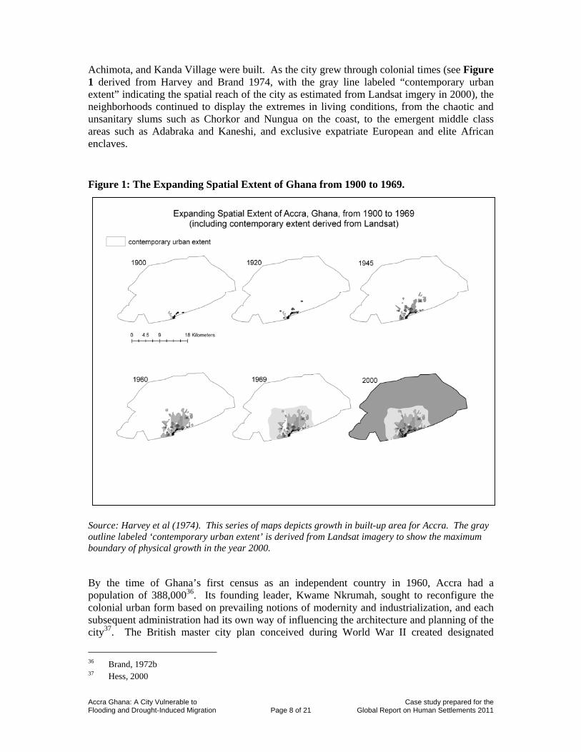
Achimota, and Kanda Village were built. As the city grew through colonial times (see Figure 1 derived from Harvey and Brand 1974, with the gray line labeled “contemporary urban extent” indicating the spatial reach of the city as estimated from Landsat imgery in 2000), the neighborhoods continued to display the extremes in living conditions, from the chaotic and unsanitary slums such as Chorkor and Nungua on the coast, to the emergent middle class areas such as Adabraka and Kaneshi, and exclusive expatriate European and elite African enclaves.
Figure 1: The Expanding Spatial Extent of Ghana from 1900 to 1969.
Source: Harvey et al (1974). This series of maps depicts growth in built-up area for Accra. The gray outline labeled ‘contemporary urban extent’ is derived from Landsat imagery to show the maximum boundary of physical growth in the year 2000.
By the time of Ghana’s first census as an independent country in 1960, Accra had a population of 388,00036. Its founding leader, Kwame Nkrumah, sought to reconfigure the colonial urban form based on prevailing notions of modernity and industrialization, and each subsequent administration had its own way of influencing the architecture and planning of the city37. The British master city plan conceived during World War II created designated
36 Brand, 1972b 37 Hess, 2000
Accra Ghana: A City Vulnerable to Case study prepared for the Flooding and Drought-Induced Migration Page 9 of 21 Global Report on Human Settlements 2011
separate spaces for inner urban squatter settlements, commercial areas, and a new middle class. But this plan was pushed aside by Nkrumah in favor of a more all encompassing plan drawn up by international architects to encourage national rather than tribal identity. Evidence of this attempt is most apparent along Accra’s water front where a large community center was built near a symbolic black star square. The beach was no longer reserved for only large European houses, but was open for the entire nation. Streets were also renamed and occasionally rerouted through once inaccessible poor neighborhoods.
Despite attempts to unify the built landscape of the city, a principal components analysis of data from 268 enumeration areas from the 1960 census discovered striking patterns of religious and ethnic segregation in Accra, principally among three groups38. The native Ga people were concentrated in the Jamestown-Usshertown core and in other settlements along the coast. The foreign-born and largely Muslim population from the north was primarily concentrated in neighborhoods such as the commercial core, Sabon Zongo, and Nima, while the non-African population are concentrated in the Ridge area, Cantonments, and the Airport Residential Area.
Researchers using census and survey data to examine what they termed the ‘uncontrolled expansion’ of Accra during the 1960s found that central Accra attracted a small amount of immigration39. More importantly the great majority of newcomers were settling in the periphery where rent was less expensive and construction of housing uncontrolled.
The housing situation in Accra as examined between 1950 and 1990 worsened40. In their macro-economic development, the rulers of newly independent Ghana continued urban-biased policies which favored Accra over other cities and regions in Ghana, which enhanced the city’s ability to “pull” migrants from other parts of the country and the greater region. By 1984, the year after a serious drought in Ghana, the city’s population had reached 970,000, an estimate which is widely believed to be an undercount. Since the late 1980s, the city has experienced an average annual growth rate of 4.3 percent as compared with a national rate of 2.8 percent. This has put tremendous pressure on housing stock and infrastructure as the city filled with new residents.
More than 50 years after Independence, these contrasting patterns between core and outlying areas persist41, although there is considerably more mixing especially in the new suburbs that ring the city, some extending many kilometers to the north and east. This has implications for predicting migration flows – and subsequent vulnerability to climate change – in the future.
A survey conducted in 199742 in the deteriorating neighborhoods of Ussher Town, James Town and other indigenous neighborhoods found a high level of dissatisfaction among urban residents, citing lack of privacy, lack of adequate facilities and facility-sharing, poor sanitation, and harassment from landlords as their basic concerns. It found that that 72-75 percent of all households in these areas shared toilet, kitchen and bathroom facilities with their landlords and/or co-tenants. In the neighborhood of Nima/Maamobi, the average number of persons per house was found to be 9.3 with each household containing 5.3 persons. Residential mobility in these areas was very low, with 67 percent of all renting households living on the same premises for seven years or more.
38 Brand, 1972b 39 Harvey and Brand, 1974 40 Konadu-Agyemang, 2001 41 Agyei-Mensah and Owusu, 2009 42 Konadu-Agyemang, 2001
Accra Ghana: A City Vulnerable to Case study prepared for the Flooding and Drought-Induced Migration Page 10 of 21 Global Report on Human Settlements 2011
A study completed in 2000 provides empirical evidence of the link between structural adjustment, economic liberalization, and the urban form of Accra, characterizing Accra’s growth as residential sprawl with unicentric tendencies, rather than either a deconcentration of urban functions or a fusion of urban and rural functions43. For Accra, globalization and economic growth have helped contribute to the city’s expansion, as depicted in Figure 1, in all directions but particularly to the north and east of the city.
Urban sprawl and traffic choked streets represent modern day Accra. An examination of Accra’s physical development from the strategic standpoint of spatial planning at both the national and local levels concluded that the fragmented pattern of Accra is the result of a planning system that is unable to sustain development44. In particular, short-sighted planning is to blame for urban sprawl in Accra.
Neighborhoods to the extreme north of Accra’s central core such as Madina, Kasuwa, and New Fadama, are satellites from the inner city neighborhoods of Nima, Sabon Zongo, and Tudu. Formed through an intra-urban process of chain migration, these new satellite areas serve as gateway neighborhoods for both recent migrants from northern Ghana, Nigeria, Niger, Mali, and Burkina as well as spillovers from the core areas45. Residents are attracted to these farther out satellite areas because they are able to afford flats in relatively clean and safe areas. Continued urban expansion overruns rural and agricultural land surrounding the city and without regard to infrastructure or planning. This leads to an over-exploitation of natural resources to satisfy various demands46.
The current urban area extent measured using Landsat Thematic Mapper satellite images for the year 2002 using a texture-based classification method, and compared to similar information for the years 1985 and 1991, indicates that urbanization of the fringe areas of Accra is occurring at a quickening pace47. This expansion in the fringe areas is occurring in a largely unplanned and uncontrolled manner, creating sprawling low-density development that is uneconomic in terms of land use48. As the city grows by filling in areas between older neighborhoods that lack roads, sewers and other infrastructure, problems are created that may prove costly to resolve down the road49. Currently, people face long, traffic filled commutes on poorly maintained roads. This situation is not currently sustainable, and promises to be less so if migration rates increase in the future.
This summary of Accra’s settlement history sets the context for assessing contemporary vulnerability to climate change. One must ask what impact a city’s particular socio-spatial conditions have on residents’ ability to withstand periodic climatic shocks including both flooding and drought. With a very long residency rate, dwellers in the oldest neighborhoods of Accra could be thought to possess social capital related to disaster preparedness that awaits additional exploration. In other, more recently settled areas of the city, urban residents may lack the roots but compensate by having a fuller stock of migration capital, having arrived in Accra from one or more other places, either other cities or rural areas.
43 Yehboah, 2000 44 Larbi, 1996 45 Agyei-Mensah and Owusu, 2009 46 Kufogbe, 1996 47 Yankson, et al., 2004 48 Moller-Jensen et al., 2005 49 Moller-Jensen et al., 2005
Accra Ghana: A City Vulnerable to Case study prepared for the Flooding and Drought-Induced Migration Page 11 of 21 Global Report on Human Settlements 2011
Vulnerability can thus be thought of as determined by a mixture of biophysical factors related to the actual location in the city, as well as socio-demographic factors50 such as dependency ratios and access to transportation. Those in poorer and more marginal lands will be more at a risk of flooding, and their plight will not be helped by their relative lack of social capital.
3.1. Locating neighborhoods vulnerable to climate change: slum index, elevation, and greenness in Accra
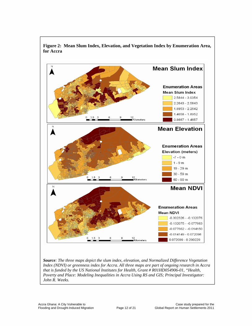
It is possible to locate neighborhoods in Accra which may be more vulnerable to the anticipated impacts of climate change such as sea level rise and flooding. Figure 2 below shows three maps of Accra divided into enumeration areas (census tracts) classified according to UN-Habitat slum index, mean elevation and a measure of greenness. All three maps are part of ongoing research in Accra that is funded by the US National Institutes for Health and led by Principal Investigator Professor John Weeks.
The slum index is the traditional one used by UN-Habitat and is composed of the following elements: inadequate access to safe water; inadequate access to sanitation and other infrastructure; poor structural quality of housing; overcrowding; and insecure residential status. Note the areas with higher slum indexes depicted by the yellow and lighter brown colors. Predictably the clusters of enumeration areas displaying the highest values for slum index were located in the old Ga neighborhoods on the coast, in the neighborhoods of Nima, Maamobi, and Sabon Zongo, and in some of the newer satellite areas on the outskirts of town.
The elevation data depicted in the next map derive from the Shuttle Radar Topography Mission, with a resolution of 90 meters. Enumeration areas with mean elevations depicted in yellow are closest to sea level, meaning they will be the first to feel the effects of a sea level rise. Those enumeration areas falling in the one to nine meter elevation class are primarily close to streams and nearer the coast, which make them more susceptible to flooding. These enumeration areas display a variety of slum conditions.
The third map depicts a Normalized Difference Vegetation Index (NDVI) or greenness index for Accra. Preliminary work by Weeks51 suggests that the amount of vegetation is associated with tree-planting efforts begun in British colonial times in Accra. Creating impervious surface through cementing outdoor living areas is a locally understood strategy to reduce flooding; however it does so by passing the problem on to those downstream. The subject of flooding will be covered next.
50 Azar and Rain, 2007 51 Weeks et al., 2007
Accra Ghana: A City Vulnerable to Case study prepared for the Flooding and Drought-Induced Migration Page 12 of 21 Global Report on Human Settlements 2011
Figure 2: Mean Slum Index, Elevation, and Vegetation Index by Enumeration Area, for Accra
Source: The three maps depict the slum index, elevation, and Normalized Difference Vegetation Index (NDVI) or greenness index for Accra. All three maps are part of ongoing research in Accra that is funded by the US National Institutes for Health, Grant # R01HD054906-01, “Health, Poverty and Place: Modeling Inequalities in Accra Using RS and GIS; Principal Investigator: John R. Weeks.
Accra Ghana: A City Vulnerable to Case study prepared for the Flooding and Drought-Induced Migration Page 13 of 21 Global Report on Human Settlements 2011
3.2. Flood modeling analysis and estimated populations at risk from flooding
Flooding is a serious environmental issue affecting Accra, and with rising sea levels it may become an even greater problem. It is expected that an increased level of cyclonic storms to a great extent and storm surges to a lesser extent will be associated with future climate change and may increase flood occurrence in spatial patterns similar to those of the present. Floods currently are usually of short duration and are caused by heavy rains that generally occur in June and July. Significant flood events have been recorded in 1973, 1986, 1995, 1999, 2001, and 2002. Along with property damage, the ability of flood waters to spread pollution from solid waste, industrial waste, and sewage is an important health and environmental issue particularly in poor areas.
The Odaw River is the major stream draining central Accra, with its outlet into the Korle Lagoon, while smaller streams lead into lagoons to the east and west of central Accra. Much of the Odaw catchment area is built up and many of the streams are channelized. Rainfall in Accra occurs in the form of intensive storm events, which cause local flooding52,53,54.
Several factors contribute to the flooding problem. First, the massive growth of the city of Accra55 has increased the extent of impervious surfaces. Impervious surfaces are materials that prevent infiltration of water into the soils, and include roads, rooftops, sidewalks, bedrock outcrops and compacted soil56. This leads to increased discharge that overloads drainage channels. Associated with this rapid urbanization are flaws in the drainage network such as undersized, unconnected or improperly channeled drains. In addition, poor development controls, limited garbage collection and disposal block channels and sewers, which slow drainage through the city57. In addition, field reconnaissance has indicated substantial uncontrolled development occurs in low-lying or unsafe areas – often immediately adjacent to and even directly over drainage channels.
Satellite data and GIS were used to develop a simple flood model to understand the impacts and possible property damage and pollutant spread in Accra. Modeled water flow volumes were compared with estimates of channel capacities to predict which drainage channels would overflow given a certain amount of rainfall. Figure 3 below illustrates the estimated amounts of overflow for each channel resulting from a 10-year 24-hour rainfall total (167.6 mm). This water would overflow the stream channels and affect the immediately adjacent areas.
The populations at risk to flooding in Accra were identified using a simple assumption that only the census enumeration areas (EAs) from the 2000 Ghana Census nearest the stream channels would be affected. The total population of EAs that border the Odaw and its tributary streams is roughly 172,000 people based on the 2000 census. This is a very conservative estimate of the number of people impacted due to current data limitations. In addition, the map displays the slum areas in Accra with the darker grays represent a higher slum index. Approximately 33,000 people live in EAs with the highest slum index. This indicates that a large portion of the population that would be impacted by flooding tend to be
52 BGR-GSD, 2006 53 Masiyandima et al., 2003 54 Hayward and Oguntoyinbo, 1987 55 Afeku, 2005 56 Arnold et al., 1996 57 Afeku, 2005

Accra Ghana: A City Vulnerable to Case study prepared for the Flooding and Drought-Induced Migration Page 14 of 21 Global Report on Human Settlements 2011
the slum dwellers who are often the poorest. With the infilling that may occur as new migrants move into the city core, there is a potential for many more people to be exposed to floods.
3.3. Water supply impacts of climate change in Accra The municipal water supply is mainly from Weija reservoir to the west of Accra, although some of the supply comes from the Akosombo Dam (Lake Volta) to the northeast. Both water sources are surface water and rely on rainfall for replenishment. Currently large portions of Accra do not have access to piped water in their dwellings. Much of Accra’s population purchases drinking water in small plastic bags, which are sold on the street corners for a few cents. This water is tested by a government agency, and results are used in the licensing procedures for water companies, ensuring a relatively consistent quality.
In addition to affecting surface water, climate change in Accra may deteriorate groundwater resources due to saltwater intrusion. The level of salt in the ground water has been mapped
Figure 3: Slum Areas in Accra at Risk from Channel Overflow
Source: Ludlow C (2009)
Accra Ghana: A City Vulnerable to Case study prepared for the Flooding and Drought-Induced Migration Page 15 of 21 Global Report on Human Settlements 2011
by the Ghana-Germany Technical Cooperation Project58. According to its report, many areas around Accra already show saltwater intrusion along with surface contamination in some areas because of inadequate cover rock. Variation in salinity depends on rock strata characteristics more than proximity to the ocean. The BGR-GSD map shows two lines of salinity – the first where salinity levels affect taste but water quality is suitable for livestock and poultry, and the second where salinity levels are too high for any sort of use.
The dwindling water supply from Lake Volta is a topic of concern among environmental planners and others in Ghana59, but as yet the concern is more over the future of power generation than the loss of water.
The concern in the climate change literature about loss of coastal mangrove forests is irrelevant in Accra, since the mangroves are already gone. But silt is a serious issue, since a clogged lagoon means more storm water backing up the system and causing flooding upstream60. Erosion along shorelines has been identified as vulnerable to human encroachment61. Beaches are composed of fluvial lagoonal sands and are highly unstable, and planners are advised to prevent any kind of construction on sand or any land surface below ten meters in elevation. Among related concerns are toxins and bacterial agents in storm water runoff, which are impounded in the lagoon for indefinite periods62.
3.4. The prognosis for Accra With an estimated 555 square kilometers in 200263, Accra continues to consume an ever-greater swath of territory in southern Ghana, with growth patterns expanding far from the formal central business district and downtown areas, and without any formal planning to speak of64 . Although no precise figures are available, the dynamic of temporary and seasonal mobility from the Sahelian countries, itself a long-term pattern, is likely to increase as climate change-related drought worsens and agricultural workers are directly affected. It is important to emphasis that the pattern of sustained migration puts more people at risk of adverse weather events and also possible sea-level rise.
A 2009 study by Ghana’s Environmental Protection Agency (EPA) under the Netherlands Climate Assistance Programme predicts Ghana’s cocoa production will be jeopardized by drought in the near future65. The EPA research estimated that over 800,000 families, including farm owners, sharecroppers and their dependents, who are directly engaged in cocoa production and whose livelihoods directly depend on cocoa would lose their livelihoods by the year 2020.
This will create an increasingly desperate situation for the internally displaced in the city, with few if any job opportunities and high transportation and living expense costs. Looking on the bright side, additional people will create additional market demand, but this is weighed
58 BGR-GSD, 2006 59 Gyau-Boakye, 2001 60 The Statesman, June 13th 2009 61 BGR-GSD, 2006 62 Boadi and Kuitunen, 2002 63 Moller-Jensen et al., 2005 64 Grant and Yankson, 2003 65 Darko, 2009
Accra Ghana: A City Vulnerable to Case study prepared for the Flooding and Drought-Induced Migration Page 16 of 21 Global Report on Human Settlements 2011
against numerous negative consequences of continued growth, including additional stress on limited resources such as water, food, farmland, and electric power.
Evidence from the past, most notably the 1968-74 and 1982-85 droughts in the Sahel, suggests that many so-called environmental refugees did eventually return to their lands with the onset of regular rainfall. With any number of climate change scenarios66 this supposition of ‘a return to normalcy’ may not be realistic. Drought will continue to focus migration flows from the interior to cities on the coast, thus amplifying long-term trends, but in a housing and infrastructural context that may not permit additional entrants without severe consequences.
66 Warner et al, 2009
Accra Ghana: A City Vulnerable to Case study prepared for the Flooding and Drought-Induced Migration Page 17 of 21 Global Report on Human Settlements 2011
References Acquah, I. (1958) “Accra Survey: A Social Survey of the Capital of Ghana, formerly called the Gold
Coast, undertaken for the West African Institute of Social and Economic Research, 1953-1956” Warwick Square, London: University of London Press
Adejuwon, J. (2005) Assessing the suitability of the epic crop model for use in the study of impacts of
climate variability and climate change in West Africa, Singapore Journal of Tropical Geography 26(1): 44-60
Afeku, K. (2005) Urbanization and Flooding in Accra, Ghana, Master’s Thesis, Department of
Geography, Miami University Agyei-Mensah, S. and O. George (2009) ‘Segregated by neighbourhoods? A portrait of ethnic
diversity in the neighbourhoods of the Accra Metropolitan Area, Ghana’, Population, Space and Place, in press
Andreini, M., N.C. van de Giesen., A. van Edig, M. Fosu and W. Andah, (2000) Volta Basin water
balance, ZEF-Discussion Papers on Development Policy, Number 21, Center for Development Research, ZEF, Bonn, Germany
Arnold, J., L. Chester and C. Gibbons (1996) ‘Impervious Surface Coverage: The Emergence of a Key
Environmental Indicator’ Journal of the American Planning Association, 62(2): 243-258 Azar, D. and D. Rain (2007) ‘Identifying Population Vulnerable to Hydrological Hazards in San Juan,
Puerto Rico’ GeoJournal 69: 23-43 BGR-GSD, (2006) ‘Ghana-Germany Technical Cooperation: Environmental and Engineering Geology
for Urban Planning in the Accra-Tema Area, 2003-2006.’ Technical Reports and Maps, CD-ROM, Bundesanstalt für Geowissenschaften und Rohstoffe (BGR) and Ghana Survey Department (GSD)
Boadi, K. O. and K. Markku, (2002) ‘Urban Waste Pollution in the Korle Lagoon, Accra, Ghana,’ The
Environmentalist, 22(4): 1573-2991 Boko, M., Niang, I., Nyong, A., Vogel, C., Githeko, A., Medany, M., Osman-Elsha, B., Tabo, R., and
P. Yanda, (2007) Climate Change 2007: Impacts, Adaptation and Vulnerability, Contribution of Working Group II to the Fourth Assessment Report of the Intergovernmental Panel of Climate Change, Cambridge, UK: Cambridge University Press
Boquier, P. (2003) ‘Analyzing urbanization in sub-Saharan Africa,’ in Champion, Tony and Graeme
Hugo, eds, New Forms of Urbanization, London: Ashgate, pp 133-52 Brand, R., (1972a) ‘A geographical interpretation of the European influence on Accra, Ghana.’
Unpublished Dissertation, Columbia University, New York
Accra Ghana: A City Vulnerable to Case study prepared for the Flooding and Drought-Induced Migration Page 18 of 21 Global Report on Human Settlements 2011
Brand, R., (1972b) ‘The spatial organization of residential areas in Accra, Ghana with particular reference to aspects of modernization’ Economic Geography, 48(3): 284-298
Brand, R., (1972c) ‘The Role of Cocoa in Growth and Spatial Organization of Accra (Ghana) Prior to
1921’, African Studies Review, 1972, Vol. 15, No. 2, 271-282 Cole, R. and H. de Blij (2006) Survey of Sub-Saharan Africa, Oxford University Press, New York Darko, S (2009) ‘Danger Looms: Bleak Future Awaits Ghana’s Cocoa,’ The Ghanaian Journal, June
8, 2009, http://www.theghanaianjournal.com/2009/06/08/danger-looms-bleak-future-awaits-ghana%E2%80%99s-cocoa/ Access date: 6-26-09
Dasgupta, S., L. Benoit, M. Biobhan, and W. David (2009) Se-Level Rise and Storm Surges: A
Comparative Analysis of Impacts in Developing Countries. Policy Research Working Paper 4901, World Bank Development Research Group, Environment and Energy Team, April 2009
Environmental Change and Forced Migration (EACH-FOR) Preliminary Findings from the EACH-
FOR project on Environmentally Induced Migration. 1 September 2008 Grant, R. and P. Yankson, (2003) ‘City Profile: Accra.’ Cities, 20(1): 65-74 Gyau-Boakye, P. (2001) ‘Environmental Impacts of the Akosombo Dam and Effects of Climate
change on the Lake Levels’ Environment, Development and Sustainability, 3(1): 17-29 Harvey, M. and R. Brand (1974) ‘The Spatial Allocation of Migrants in Accra, Ghana’ Geographical
Review, Vol. 64, No. 1, pp. 1-30 Hayward, D.F and J.S. Oguntoyinbo (1987) ‘Climatology of West Africa,’ HarperCollins Publishers
Ltd Hess, J. B. (2000) ‘Imaging Architecture: The Structure of Nationalism in Accra, Ghana.’ Africa
Today 47 (2) 35-58 Hewawasam, I. (2002) Managing the Marine and coastal Environment of Sub-Saharan Africa:
Strategic Directions for Sustainable Development, World Bank Report Number 24634, July 2002
Hulme, M. (1992) Rainfall changes in Africa: 1931-1960 to 1961-1990, International Journal of
Climatology, 12: 685-699 Keah, R.W.J (1959) An Outline of Nigerian Vegetation, Government Printer, Lagos Konadu-Agyemang, K, (2001) ‘A survey of housing conditions and characteristics in Accra, an
African city,’ Habitat International, 25: 15-34 Kufogbe, S., (1996) ‘Urbanization and changing patterns of land-use in the peri-urban zone along the
Airport-Ayimensah transect of Accra, Ghana,’ London: Royal Institute of Chartered Surveyors
Accra Ghana: A City Vulnerable to Case study prepared for the Flooding and Drought-Induced Migration Page 19 of 21 Global Report on Human Settlements 2011
L’Hóte, Y., G. Mahé., B. Some and J.P. Triboulet, (2002) Analysis of a Sahelian annual rainfall index
from 1896 to 2000; the drought continues; Hydrological Science Journal, 48(3): 489-496 Larbi, W.O., (1996) ‘Spatial planning and urban fragmentation in Accra’, Third World Planning
Review, 18, 2: 193-215 Lezine, A.M., J. Duplessy and J. Cazet (2005) West African monsoon variability during the last
deglaciation and the Holocene: Evidence from fresh water algae, pollen and isotope data from core KW31, Gulf of Guinea, Palaeogeography, Palaeoclimatology, Palaeoecology, 219: 225-237
Ludlow, C. (2009) “Flood Modeling in a Data-Poor Region: A Satellite Data-Supported Flood Model
for Accra, Ghana” Paper presented at the annual meeting of the Association for American Geographers in Las Vegas, Nevada
Mahé, G. and J.C. Olivry (1999) Assessment of freshwater yields to the ocean along the intertropical
Atlantic coast of Africa, Comptes Rendus de l’Académie des Sciences, Paris, 328: 328-621 Masiyandima, M.C., N. van de Giesen, D. Sitapha, P.N. Windmeijer and T.S. Steenhuis (2003) ‘The
hydrology of inland valleys in the sub-humid zone of West Africa: rainfall-runoff processes in the M’be experimental watershed’ Hydrological Processes, 17: 1213-1225
Matthews, A.J. (2002) Intra-seasonal variability over West Africa, In: Proceedings of the 25th
Conference on Hurricanes and Tropical Meteorology, San Diego, pp. 652-653 Matthews, A.J. (2003) ‘Intra-seasonal variability over tropical Africa during northern summer’
Climate, 17: 2427-2440 McGranahan, G., D. Balk, and B. Anderson (2007) ‘The rising tide: assessing the risks of climate
change and human settlements in low elevation coastal zones’ Environment and Urbanization 19, 1: 17-37
Moller-Jensen, L., R. Kofie and P. Yankson, (2005) ‘Large-area urban growth observations – a
hierarchical kernel approach based on image texture.’ Geografisk Tidsskrift, Danish Journal of Geography 105(2):39-47
Montgomery, M. (2008) ‘The urban transformation of the developing world’, Science 319: 761-764 Mountjoy, A.B and E. Clifford, (1967) Africa: A New Geographical Survey, Praeger, New York Muff, R., R. Okla, Y.M. Anokwa, E. Brakohiapa, R.Brown, D.R. Edifor, E. Efa, T. Abel and G.
Leydecker, (2006) Geoinformation for Land Use Planning and Urban Development in the Greater Accra Metropolitan Area with Schematic Map of Suggested Land Use 1:100 000 and Geohazards Map 1:100 000, Ghana-Germany Technical Cooperation: Environmental and Engineering Geology for Urban Planning in the Accra-Tema Area, 2003-2006. Bundesanstalt für Geowissenschaften und Rohstoffe (BGR) and Ghana Survey Department (GSD), Accra/Hannover, July 2006
Accra Ghana: A City Vulnerable to Case study prepared for the Flooding and Drought-Induced Migration Page 20 of 21 Global Report on Human Settlements 2011
Murdock, G.P. (1960) ‘Staple subsistence crops of Africa’, The Geographical Review, 50: 523-540 Myers, N. (2001) ‘Environmental refugees: a growing phenomenon of the 21st century’, Philosophical
Transactions of the Royal Society London B. 357: 609-613 Oguntunde, P.G., F. J. van de Giesen, and Savenije, H.G. Hubert., (2006) Hydroclimatology of the
Volta River Basin in West Africa: Trends and variability from 1901 to 2002. Physics and Chemistry of the Earth, 31: 1180-1188
Oppku-Ankomah, P.G. and B.A. Amisigo (1998) Rainfall and runoff variability in the southwestern
river system of Ghana, In: Servat, E., D. Hughes, J.M.Fritsch and M. Hulm, M. (Eds.), Water Resources Variability in African during the XXth Century (Proceedings of the Abijan ’98 Conference heal and Abijan, Côte d’Ivoire, November 1998), IAHS Publication, vol. 252, IAHS Press, INST. Hyd., Wallingford, UK, pp. 307-314
Ozer, P., M. Erpicum, M. Demaree and M. Vandiepenbeeck (2003) Discussion of “analysis of a
Sahelian annual rainfall index from 1896 to 2000; the drought continues” The drought may have ended during the 1990s, Hydrological Science Journal, 47(4): 563-572
Pellow, D. (2000) ‘Cultural Differences and Urban Spatial Forms: Elements of Boundedness in an
Accra Community.’ Department of Anthropology Syracuse University Quarcoopome, S.S. (1993) A History of the Urban Development of Accra: 1877 – 1957, Research
Review (NS), 9(1&2): 20-32 Rain, D. (1999) Eaters of the Dry Season, Boulder: Westview Press. Sultan, B and S. Janicot (2000) ‘Abrupt shift of the ITCS over West Africa and intra-seasonal
variability,’ Geophys, Res. Lett.27: 3353-3356 Sultan, B., B. Christian, D. Michael, S. Benoit and J. Serge (2005) ‘Agricultural impacts of large-scale
variability of the West African monsoon,’ Agricultural and Forest Meteorology, 128: 93-110 The Statesman (2009) A silted Korle Lagoon means more flooding’, June 13th 2009,
(http://www.thestatesmanonline.com/pages/archive_detail.php?newsid=3737) Tiffen, M. (2003) Transition in Sub-Saharan Africa: Agriculture, Urbanization and Income Growth,
World Development, 31(8): 1343-1366 United Nations (2008) World Urbanization Prospects, the 2007 Revision, Department of Economic
and Social Affairs, Population Division, New York: The United Nations United Nations Human Settlements Programme (UN Habitat) (2008) ‘African cities at risk due to sea-
level rise’ (http://www.preventionweb.net/english/professional/maps/v.php?id=5645) Accessed 25 June 2009
Accra Ghana: A City Vulnerable to Case study prepared for the Flooding and Drought-Induced Migration Page 21 of 21 Global Report on Human Settlements 2011
Warner, K. (2009) In Search of Shelter: Mapping the Effects of Climate Change on Human Migration and Displacement. United Nations University Institute for Environment and Human Security (UNU-EHS), CARE International, and Columbia University’s Center for International Earth Science Information Network (CIESIN)
Weeks, J.R., H. Allan, S. Douglas, G. Arthur, and D. Fugate (2007) Can We Spot a Neighborhood
from the Air? Defining Neighborhood Structure in Accra, Ghana, GeoJournal 69: 9-22 Yankson, P.W., R.Y. Kofie and L. Moller-Jensen (2004) Monitoring Urban Growth: Urbanization of
the Fringe Areas of Accra, Bulletin of the Ghana Geographical Association Yehboah, I. E.A (2000) ‘Structural Adjustment and Emerging Urban Form in Accra, Ghana’, Africa
Today, 47(2): 61-89