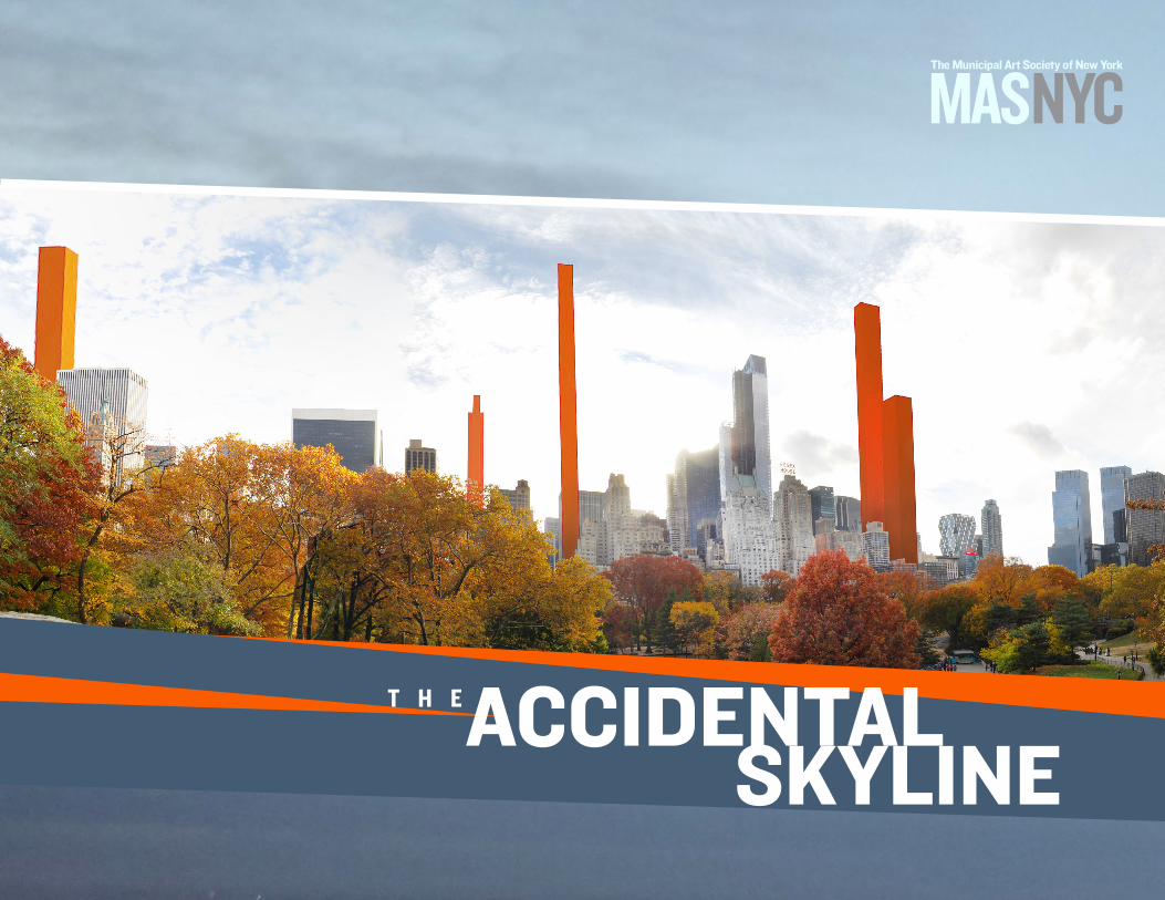
Accidental Skyline
42
T H E
-
Upload
the-municipal-art-society-of-new-york -
Category
Documents
-
view
7.539 -
download
6
description
A report addressing the issues surrounding tall buildings and their influence on the scarce open spaces in New York – particularly West 57th Street and Central Park.
Transcript of Accidental Skyline
1
T H E
THE ACCIDENTAL SKYLINE2
Letter from MAS
Executive Summary
MAS and Central Park
A Brief History of New York’s Skyline
Why So Tall?
Projects Now Underway
Case Study: 217 West 57th St.
What’s the Issue?
Potential Solutions
Appendix A: How Do TDR’s Work?
Appendix B: Active Projects Summary Table
Sources
Acknowledgments
4
6
10
12
16
18
20
22
30
34
37
38
40
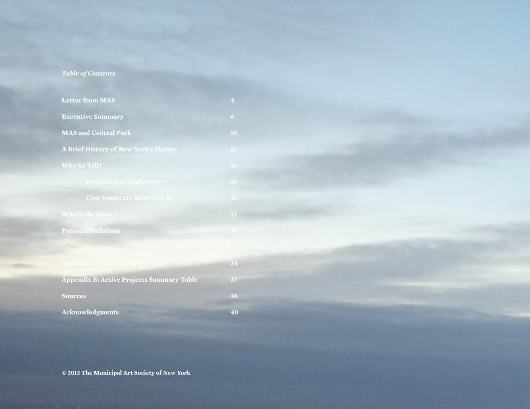
Table of Contents
© 2013 The Municipal Art Society of New York
3
A REPORT BY
DECEMBER 2013
T H E
THE ACCIDENTAL SKYLINE4
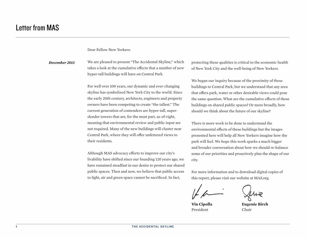
Dear Fellow New Yorkers:
We are pleased to present “The Accidental Skyline,” which takes a look at the cumulative effects that a number of new hyper-tall buildings will have on Central Park.
For well over 100 years, our dynamic and ever-changing skyline has symbolized New York City to the world. Since the early 20th century, architects, engineers and property owners have been competing to create “the tallest.” The current generation of contenders are hyper-tall, super-slender towers that are, for the most part, as-of-right, meaning that environmental review and public input are not required. Many of the new buildings will cluster near Central Park, where they will offer unfettered views to their residents.
Although MAS advocacy efforts to improve our city’s livability have shifted since our founding 120 years ago, we have remained steadfast in our desire to protect our shared public spaces. Then and now, we believe that public access to light, air and green space cannot be sacrificed. In fact,
protecting these qualities is critical to the economic health of New York City and the well-being of New Yorkers.
We began our inquiry because of the proximity of these buildings to Central Park, but we understand that any area that offers park, water or other desirable views could pose the same question: What are the cumulative effects of these buildings on shared public spaces? Or more broadly, how should we think about the future of our skyline?
There is more work to be done to understand the environmental effects of these buildings but the images presented here will help all New Yorkers imagine how the park will feel. We hope this work sparks a much bigger and broader conversation about how we should re-balance some of our priorities and proactively plan the shape of our city.
For more information and to download digital copies of this report, please visit our website at MAS.org.
Vin CipollaPresident
Eugenie BirchChair
Letter from MAS
December 2013
THE ACCIDENTAL SKYLINE 5
Eugenie BirchChair
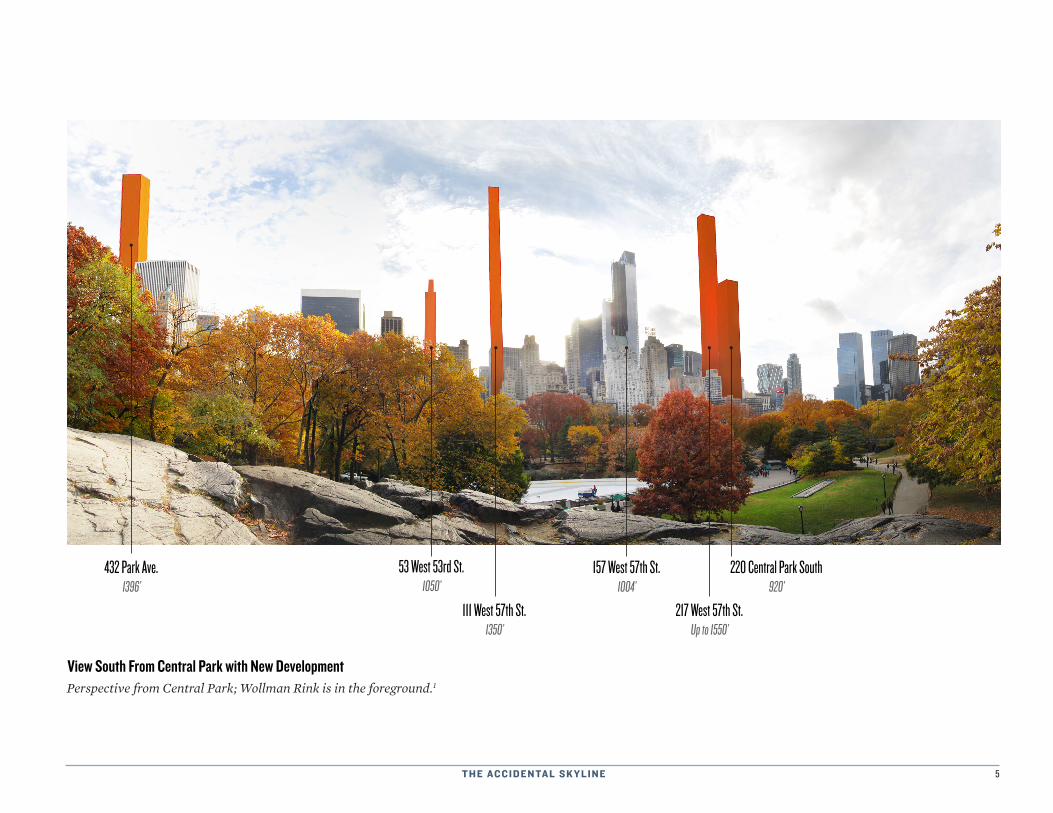
View South From Central Park with New DevelopmentPerspective from Central Park; Wollman Rink is in the foreground.1
111 West 57th St.1350’
217 West 57th St.Up to 1550’
220 Central Park South920’
157 West 57th St.1004’
432 Park Ave.1396’
53 West 53rd St.1050’
THE ACCIDENTAL SKYLINE6
Executive Summary
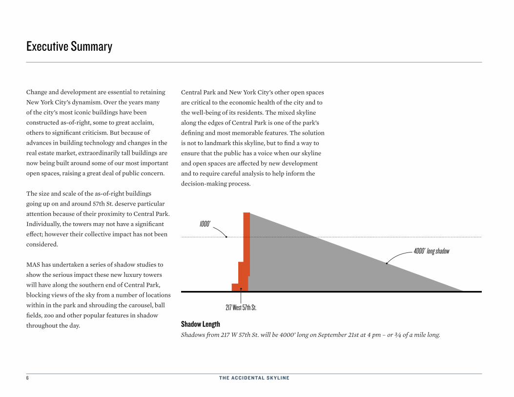
Change and development are essential to retaining New York City’s dynamism. Over the years many of the city’s most iconic buildings have been constructed as-of-right, some to great acclaim, others to significant criticism. But because of advances in building technology and changes in the real estate market, extraordinarily tall buildings are now being built around some of our most important open spaces, raising a great deal of public concern.
The size and scale of the as-of-right buildings going up on and around 57th St. deserve particular attention because of their proximity to Central Park. Individually, the towers may not have a significant effect; however their collective impact has not been considered.
MAS has undertaken a series of shadow studies to show the serious impact these new luxury towers will have along the southern end of Central Park, blocking views of the sky from a number of locations within in the park and shrouding the carousel, ball fields, zoo and other popular features in shadow throughout the day.
Central Park and New York City’s other open spaces are critical to the economic health of the city and to the well-being of its residents. The mixed skyline along the edges of Central Park is one of the park’s defining and most memorable features. The solution is not to landmark this skyline, but to find a way to ensure that the public has a voice when our skyline and open spaces are affected by new development and to require careful analysis to help inform the decision-making process.
Shadow LengthShadows from 217 W 57th St. will be 4000’ long on September 21st at 4 pm – or ¾ of a mile long.
217 West 57th St.
4000’ long shadow
1000’
THE ACCIDENTAL SKYLINE 7
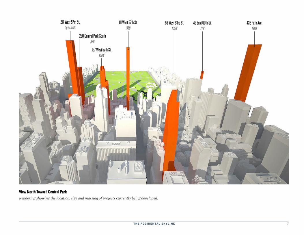
View North Toward Central ParkRendering showing the location, size and massing of projects currently being developed.
111 West 57th St.1350’
217 West 57th St.Up to 1500’
220 Central Park South920’
43 East 60th St.779’
157 West 57th St.1004’
432 Park Ave.1396’
53 West 53rd St.1050’
THE ACCIDENTAL SKYLINE8
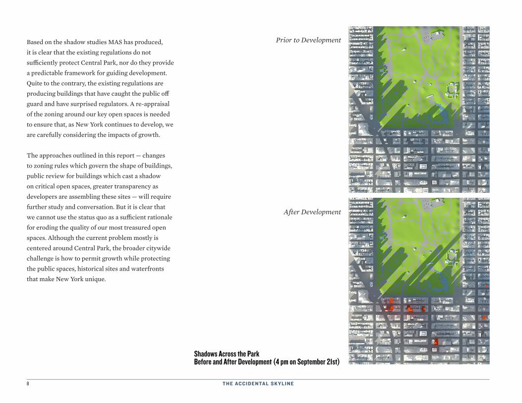
Shadows Across the Park Before and After Development (4 pm on September 21st)
Prior to Development
After Development
Based on the shadow studies MAS has produced, it is clear that the existing regulations do not sufficiently protect Central Park, nor do they provide a predictable framework for guiding development. Quite to the contrary, the existing regulations are producing buildings that have caught the public off guard and have surprised regulators. A re-appraisal of the zoning around our key open spaces is needed to ensure that, as New York continues to develop, we are carefully considering the impacts of growth.
The approaches outlined in this report — changes to zoning rules which govern the shape of buildings, public review for buildings which cast a shadow on critical open spaces, greater transparency as developers are assembling these sites — will require further study and conversation. But it is clear that we cannot use the status quo as a sufficient rationale for eroding the quality of our most treasured open spaces. Although the current problem mostly is centered around Central Park, the broader citywide challenge is how to permit growth while protecting the public spaces, historical sites and waterfronts that make New York unique.
THE ACCIDENTAL SKYLINE 9
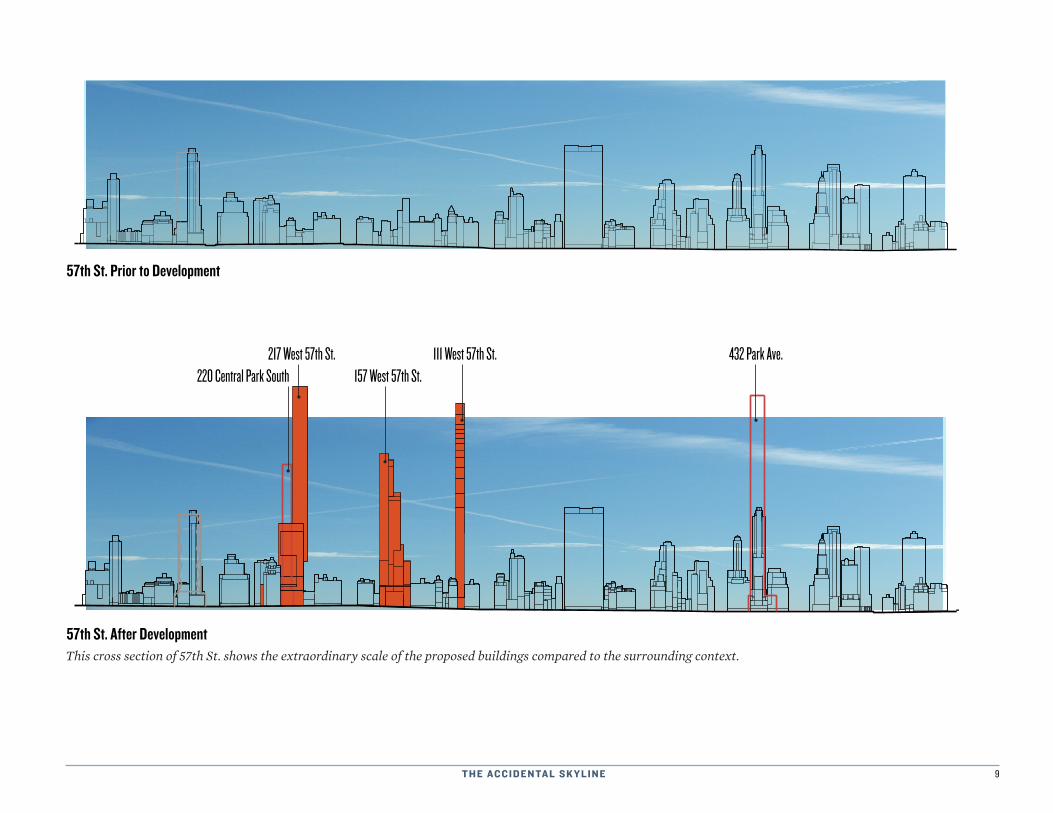
57th St. After Development
57th St. Prior to Development
217 West 57th St. 111 West 57th St. 432 Park Ave.157 West 57th St.220 Central Park South
This cross section of 57th St. shows the extraordinary scale of the proposed buildings compared to the surrounding context.
THE ACCIDENTAL SKYLINE10
Even a hundred years ago, New York City’s skyline
was called, “the most stupendous unbelievable
manmade spectacle since the hanging gardens
of Babylon.”2 For over a century, the demand for
land, advancing technology and intense ambition
to create the tallest building in the world has
transformed New York City’s skyline. However,
what began as a utilitarian response to urbanization
in downtown Manhattan has increasingly become
an extravagant way to offer a small number of
people their own private aeries.
For the most part, today’s buildings are being
constructed as-of-right, meaning without any kind
of public review or decision-maker discretion.
As-of-right buildings require no environmental
assessment or meaningful public input.
Consequently, many people are unaware that the
cluster of buildings described in this report will
be some of North America’s tallest and that no
city agency is examining how these buildings will
affect the environment. The views from across New
York City are being remade without the level of
discussion which should be required for changes of
this scale to take place.
Since the Municipal Art Society’s (MAS) founding
120 years ago, we have advocated for the protection
and enhancement of New York’s greatest assets,
including the city’s shared public spaces. From
defending Central Park against encroaching
development to advocating for the country’s first
zoning resolution, MAS has supported the aspects
essential to New York City’s livability. Throughout
our history, we’ve maintained that access to light,
air, and green space in urban areas are indispensable
because they underlie the very factors that
encourage growth. Central Park provides all of these
elements in abundance and any new development
surrounding the park should continue to support
the health and vitality it affords the public.
MAS has fought some hard-won battles over the
years, many of them about Central Park. These
include: opposing signage, the construction of the
subway along the western edge and overcoming
Robert Moses’ plan to build a recreation center
in Central Park’s deteriorated woodlands — and
instead facilitating the restoration of the cherished
Ramble between 73rd and 78th St.3
Most of the early issues facing Central Park were
about activities and architecture within the park.
That changed in the 1980s. The southwestern
corner of Central Park was a jumble of haphazard
architecture and disastrous traffic patterns. The
Coliseum, a utilitarian convention hall, was set to
be demolished and redeveloped as a mixed use site
through a Request for Proposals process overseen
by the MTA.4 The winning bid was a development
of two towers 58 and 68 stories tall containing
approximately 2.7 million square ft. MAS filed
a lawsuit arguing that the City essentially sold a
zoning bonus to the developer.5
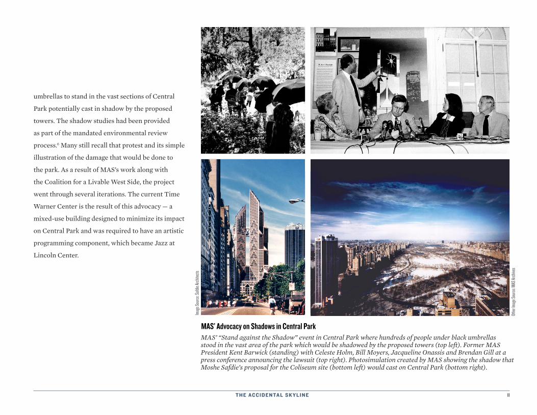
In 1987, as part of its advocacy campaign against
oversized development around Central Park, MAS
staged a “Stand Against the Shadow,” event which
organized hundreds of protestors wielding black
MAS and Central Park
THE ACCIDENTAL SKYLINE 11
MAS’ Advocacy on Shadows in Central ParkMAS’ “Stand against the Shadow” event in Central Park where hundreds of people under black umbrellas stood in the vast area of the park which would be shadowed by the proposed towers (top left). Former MAS President Kent Barwick (standing) with Celeste Holm, Bill Moyers, Jacqueline Onassis and Brendan Gill at a press conference announcing the lawsuit (top right). Photosimulation created by MAS showing the shadow that Moshe Safdie’s proposal for the Coliseum site (bottom left) would cast on Central Park (bottom right).
umbrellas to stand in the vast sections of Central
Park potentially cast in shadow by the proposed
towers. The shadow studies had been provided
as part of the mandated environmental review
process.6 Many still recall that protest and its simple
illustration of the damage that would be done to
the park. As a result of MAS’s work along with
the Coalition for a Livable West Side, the project
went through several iterations. The current Time
Warner Center is the result of this advocacy — a
mixed-use building designed to minimize its impact
on Central Park and was required to have an artistic
programming component, which became Jazz at
Lincoln Center.
Imag
e Sou
rce: S
afdie
Archit
ects
Othe
r Imag
e Sou
rce: M
AS Ar
chive
s
THE ACCIDENTAL SKYLINE12
Skyscrapers are pervasive in New York City. Viewed
individually, they stand as emblems of some of
New York’s most defining architectural styles and
moments of historical significance. Collectively, they
comprise New York’s famous, frequently-changing
skyline.
Early History
The impulse for taller buildings dates back to
the mid-19th century. Revolutions in industry,
commerce and communication drew vast numbers
of people to the city, driving up the demand and
cost of land. The need to accommodate the swell
in population inspired a new strategy for building
taller. Technological advances facilitating the
quest for height included the invention of steel
framing, elevators, fireproofing, and amenities such
as telephones and sanitary facilities.7 By the early
20th century, tall commercial buildings began to
dominate the Lower Manhattan skyline previously
shaped by church steeples and bridges.
Among the first to recognize the advertising value
of taller buildings were the media moguls clustered
along Park Row, at the time called Newspaper Row.8
Prominently situated across from City Hall, Joseph
Pulitzer’s 1890 World Building was the first to be
taller than Trinity Church’s 284 ft. tall spire, with its
golden dome topping out at 309 ft. (20 stories).9 The
World Building set the record for tallest building
for almost a decade. Each subsequent record-holder
was similarly short lived until Cass Gilbert’s 1913
Woolworth Building which rose to 792 ft. tall (58
stories) and prevailed as the tallest “Cathedral of
Commerce” until after World War I.10
At the same time these towers were competing,
the 1915 Equitable Building, though not the tallest,
became the world’s most massive office building
with over 1,200,000 square ft. of rentable office
space. The 38-story building rose straight up from
the sidewalk, blocking sunlight to surrounding
offices. The building became an impetus for the 1916
Zoning Resolution’s requirements for new buildings
A Brief History of New York’s Skyline
to setback in order to allow light and air to reach
neighboring properties and the street.11
Post-War, Post-Zoning Development
The 1920s post-war period was characterized
by an economic boom driven by the financial
and corporate sectors. New soaring wedding-
cake skyscrapers responded to the 1916 Zoning
Resolution, and served as corporate calling cards for
headquarters in the financial district and Midtown.
In 1930, the Manhattan Company Building at 40
Wall St. (927 ft. tall; 70 stories) was the first to
challenge the Woolworth’s Building’s record height
but was stymied immediately following construction
by the clandestine addition of a towering spire to
its midtown rival, the Chrysler Building (1,046 ft.
tall, 102 stories).12 The competition continued, as
Chrysler’s status was quickly eclipsed by the Empire
State Building, which swept the title away, rising
1,250 ft. (102 stories).
THE ACCIDENTAL SKYLINE 13
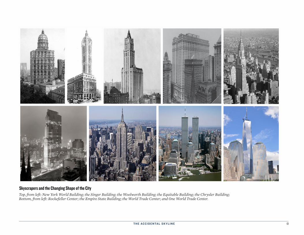
Skyscrapers and the Changing Shape of the CityTop, from left: New York World Building; the Singer Building; the Woolworth Building; the Equitable Building; the Chrysler Building; Bottom, from left: Rockefeller Center; the Empire State Building; the World Trade Center; and One World Trade Center.
THE ACCIDENTAL SKYLINE14
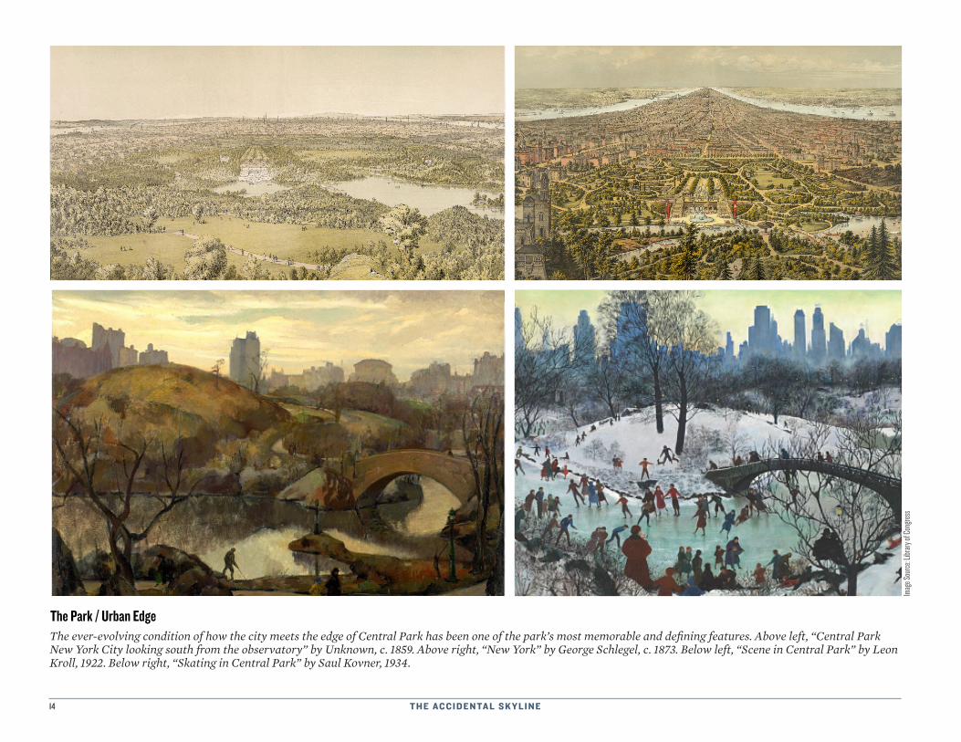
The Park / Urban EdgeThe ever-evolving condition of how the city meets the edge of Central Park has been one of the park’s most memorable and defining features. Above left, “Central Park New York City looking south from the observatory” by Unknown, c. 1859. Above right, “New York” by George Schlegel, c. 1873. Below left, “Scene in Central Park” by Leon Kroll, 1922. Below right, “Skating in Central Park” by Saul Kovner, 1934.
Imag
e Sou
rce: L
ibrary
of Co
ngres
s
THE ACCIDENTAL SKYLINE 15
These and other skyscrapers became national icons.
The buildings served thousands of workers and
often included well-designed subway connections,
commercial and retail uses for tenants and the
public. Historically, these structures shared the
thrill of their extraordinary heights with the broader
public by maintaining upper floor observation decks
in commercial buildings (Woolworth Building,
the original Madison Square Garden, Chrysler
Building, Rockefeller Center), restaurants (90
West St. Building, Rainbow Room, Top of the
Sixes, Gulf & Western, Panhellenic Hotel) private
clubs (Downtown Athletic Club, Cloud Club), and
panoramas from public plazas (Chase Manhattan
Plaza, Rockefeller Center). Following tradition, the
World Trade Center broke the world height record
in 1970 and offered both an observation deck and
the Windows to the World restaurant on its top
floors.
Today: Billionaire’s Row
Over the last 30 years the skyscraper has evolved
from a symbol of the city’s commercial power.
Today’s tall towers are no longer concentrated in
industry-specific locations but simply on sites that
offer unrestricted views. As the Skyscraper museum
has documented in an on-going exhibition, these
thin buildings represent a new type of skyscraper in
a city where tall and slender buildings have a long
history.
Residential skyscrapers have become increasingly
widespread and access to unrestricted views is
now a highly desired commodity for the world’s
richest patrons. Technological advances have also
allowed buildings of greater heights on smaller lots,
making it easier for tall buildings to locate anywhere
regulations permit. These unprecedented buildings
result from negotiations made between property
owners who have creatively worked around zoning
constraints by purchasing development rights from
neighboring properties.
Image Source: The Skyscraper Museum
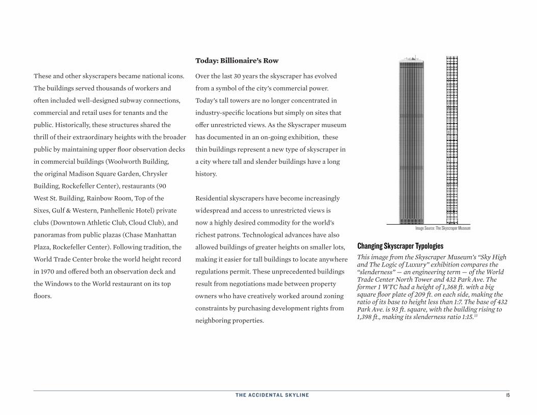
Changing Skyscraper TypologiesThis image from the Skyscraper Museum’s “Sky High and The Logic of Luxury” exhibition compares the “slenderness” — an engineering term — of the World Trade Center North Tower and 432 Park Ave. The former 1 WTC had a height of 1,368 ft. with a big square floor plate of 209 ft. on each side, making the ratio of its base to height less than 1:7. The base of 432 Park Ave. is 93 ft. square, with the building rising to 1,398 ft., making its slenderness ratio 1:15.13
THE ACCIDENTAL SKYLINE16
Luxury housing development is booming in
Manhattan. According to CityRealty the number
of condominium buildings in Manhattan with
apartments selling for more than $15 million has
risen 48% since 2009.14 Developers are catering to
the global elite and ultra-rich who will pay premium
prices for apartments with lavish interiors, private
wine cellars and, above all, spectacular views.
Located just two blocks south of Central Park,
the stretch of 57th St. between Park and Eighth
avenues has some of New York City’s best views.
The street’s width and location in an area zoned
to accommodate higher density also permits the
construction of super-tall towers.
To be able to build these tall luxury towers, savvy
developers have spent a great deal of time and money
assembling zoning lots in order to take advantage of
multiple sources of what are known as “air rights.”
Primarily through zoning lot mergers — private
agreements between adjacent property owners —
developers have accumulated enough additional
Why So Tall?
air rights to build extraordinarily tall towers on
relatively small sites as-of-right. With the addition
of these buildings, many of these blocks will have
exhausted their development potential — but
undoubtedly there are other developers working
across the City to assemble development rights to
create new skyscrapers.
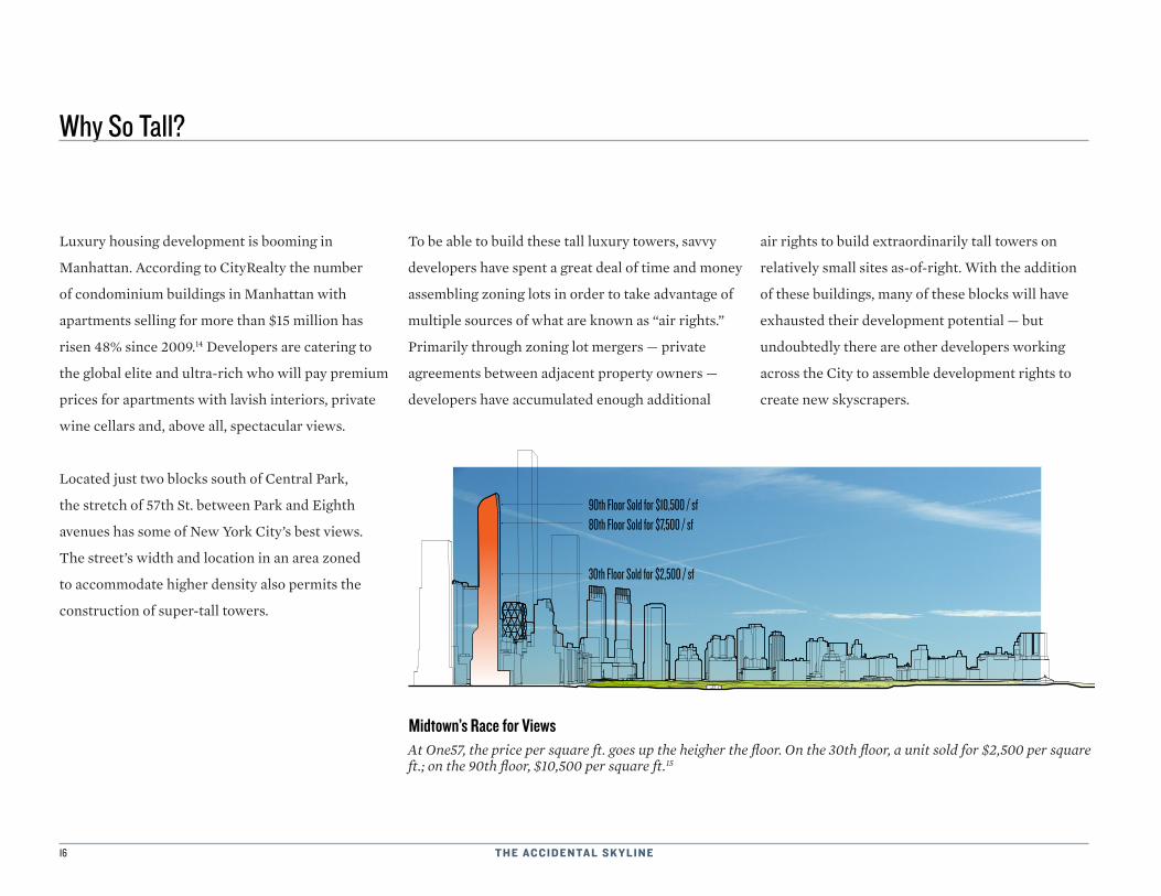
Midtown’s Race for ViewsAt One57, the price per square ft. goes up the heigher the floor. On the 30th floor, a unit sold for $2,500 per square ft.; on the 90th floor, $10,500 per square ft.15
90th Floor Sold for $10,500 / sf80th Floor Sold for $7,500 / sf
30th Floor Sold for $2,500 / sf
THE ACCIDENTAL SKYLINE 17
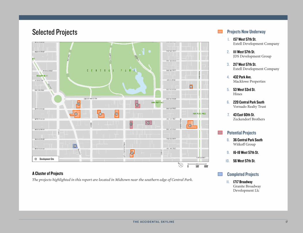
Selected Projects
1000’
0 500’ 1000’
N
1 2
5
8
910
11
3
4
6
7
Development Site#
157 West 57th St.Extell Development Company
111 West 57th St.JDS Development Group
217 West 57th St.Extell Development Company
432 Park Ave.Macklowe Properties
53 West 53rd St. Hines
220 Central Park South Vornado Realty Trust
43 East 60th St.Zeckendorf Brothers
36 Central Park SouthWitkoff Group
16-18 West 57th St.
56 West 57th St.
1717 Broadway Granite Broadway Development Llc
1.
2.
3.
4.
5.
6.
7.
8.
9.
10.
11.
A Cluster of Projects The projects highlighted in this report are located in Midtown near the southern edge of Central Park.
Projects Now Underway
Potential Projects
Completed Projects
THE ACCIDENTAL SKYLINE18
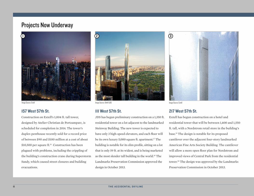
157 West 57th St.Construction on Extell’s 1,004 ft. tall tower,
designed by Atelier Christian de Portzamparc, is
scheduled for completion in 2014. The tower’s
duplex penthouse recently sold for a record price
of between $90 and $100 million at a cost of about
$10,500 per square ft.16 Construction has been
plagued with problems, including the crippling of
the building’s construction crane during Superstorm
Sandy, which caused street closures and building
evacuations.
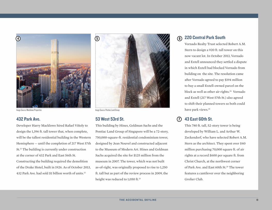
111 West 57th St.JDS has begun preliminary construction on a 1,350 ft.
residential tower on a lot adjacent to the landmarked
Steinway Building. The new tower is expected to
have only 3 high-speed elevators, and each floor will
be its own luxury 5,000 square ft. apartment.17 The
building is notable for its slim profile, sitting on a lot
that is only 59 ft. at its widest, and is being marketed
as the most slender tall building in the world.18 The
Landmarks Preservation Commission approved the
design in October 2013.
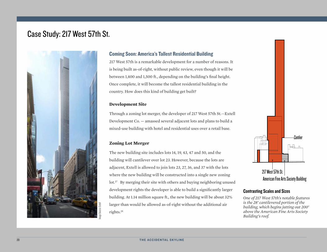
217 West 57th St.Extell has begun construction on a hotel and
residential tower that will be between 1,400 and 1,550
ft. tall, with a Nordstrom retail store in the building’s
base.19 The design is notable for its proposed
cantilever over the adjacent four-story landmarked
American Fine Arts Society Building. The cantilever
will allow a more open floor plan for Nordstrom and
improved views of Central Park from the residential
tower.20 The design was approved by the Landmarks
Preservation Commission in October 2013.
TOWER MASSING //
21 3
Projects Now Underway
Image Source: SHoP/JDSImage Source: Extell Image Source: Extell
THE ACCIDENTAL SKYLINE 19
432 Park Ave.Developer Harry Macklowe hired Rafael Viñoly to
design the 1,396 ft. tall tower that, when complete,
will be the tallest residential building in the Western
Hemisphere — until the completion of 217 West 57th
St.21 The building is currently under construction
at the corner of 432 Park and East 56th St.
Constructing the building required the demolition
of the Drake Hotel, built in 1926. As of October 2013,
432 Park Ave. had sold $1 billion worth of units.22
53 West 53rd St.This building by Hines, Goldman Sachs and the
Pontiac Land Group of Singapore will be a 72-story,
750,000-square-ft. residential condominium tower,
designed by Jean Nouvel and constructed adjacent
to the Museum of Modern Art. Hines and Goldman
Sachs acquired the site for $125 million from the
museum in 2007. The tower, which was not built
as-of-right, was originally proposed to rise to 1,250
ft. tall but as part of the review process in 2009, the
height was reduced to 1,050 ft.23
43 East 60th St.This 780 ft. tall, 52-story tower is being
developed by William L. and Arthur W.
Zeckendorf, who have selected Robert A.M.
Stern as the architect. They spent over $40
million purchasing 70,000 square ft. of air
rights at a record $600 per square ft. from
Christ Church, at the northwest corner
of Park Ave. and East 60th St.26 The tower
features a cantilever over the neighboring
Grolier Club.
220 Central Park SouthVornado Realty Trust selected Robert A.M.
Stern to design a 920 ft. tall tower on this
now vacant lot. In October 2013, Vornado
and Extell announced they settled a dispute
in which Extell had blocked Vornado from
building on the site. The resolution came
after Vornado agreed to pay $194 million
to buy a small Extell-owned parcel on the
block as well as other air rights.24 Vornado
and Extell (217 West 57th St.) also agreed
to shift their planned towers so both could
have park views.25
4 5 6
Image Source: Macklowe Properties Image Source: Pontiac Land Group
7
THE ACCIDENTAL SKYLINE20
Case Study: 217 West 57th St.
Coming Soon: America’s Tallest Residential Building217 West 57th is a remarkable development for a number of reasons. It
is being built as-of-right, without public review, even though it will be
between 1,400 and 1,500 ft., depending on the building’s final height.
Once complete, it will become the tallest residential building in the
country. How does this kind of building get built?
Development Site
Through a zoning lot merger, the developer of 217 West 57th St.—Extell
Development Co. — amassed several adjacent lots and plans to build a
mixed-use building with hotel and residential uses over a retail base.
Zoning Lot Merger
The new building site includes lots 14, 19, 43, 47 and 50, and the
building will cantilever over lot 23. However, because the lots are
adjacent, Extell is allowed to join lots 23, 27, 36, and 37 with the lots
where the new building will be constructed into a single new zoning
lot.27 By merging their site with others and buying neighboring unused
development rights the developer is able to build a significantly larger
building. At 1.14 million square ft., the new building will be about 32%
larger than would be allowed as-of-right without the additional air
rights.28
217 West 57th St.
Cantilver
American Fine Arts Society Building
Imag
e Sou
rce: E
xtell
Contrasting Scales and SizesOne of 217 West 57th’s notable features is the 28’ cantilevered portion of the building, which begins jutting out 200’ above the American Fine Arts Society Building’s roof.
THE ACCIDENTAL SKYLINE 21
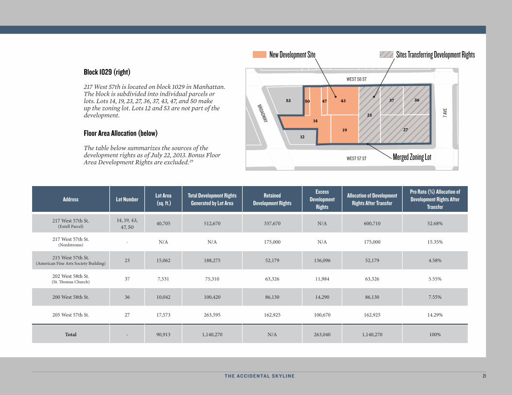
Address Lot NumberLot Area (sq. ft.)
Total Development Rights Generated by Lot Area
Retained Development Rights
Excess Development
Rights
Allocation of Development Rights After Transfer
Pro Rata (%) Allocation of Development Rights After
Transfer
217 West 57th St. (Extell Parcel)
14, 19, 43, 47, 50
40,705 512,670 337,670 N/A 600,710 52.68%
217 West 57th St.(Nordstroms) - N/A N/A 175,000 N/A 175,000 15.35%
215 West 57th St. (American Fine Arts Society Building) 23 15,062 188,275 52,179 136,096 52,179 4.58%
202 West 58th St. (St. Thomas Church) 37 7,531 75,310 63,326 11,984 63,326 5.55%
200 West 58th St. 36 10,042 100,420 86,130 14,290 86,130 7.55%
205 West 57th St. 27 17,573 263,595 162,925 100,670 162,925 14.29%
Total - 90,913 1,140,270 N/A 263,040 1,140,270 100%
Block 1029 (right)
Floor Area Allocation (below)
217 West 57th is located on block 1029 in Manhattan. The block is subdivided into individual parcels or lots. Lots 14, 19, 23, 27, 36, 37, 43, 47, and 50 make up the zoning lot. Lots 12 and 53 are not part of the development.
The table below summarizes the sources of the development rights as of July 22, 2013. Bonus Floor Area Development Rights are excluded.29
1
27
2314
4353 36
19
37
12
50 47
C E N T R A L P A R K
WEST 57 ST
WEST 56 STREET
WEST 58 ST
8 AVE
NUE
BROADWAY
CENTRAL PARK SOUTH
7 AVE
New Development Site Sites Transferring Development Rights
Merged Zoning Lot
1
27
2314
4353 36
19
37
12
50 47
C E N T R A L P A R K
WEST 57 ST
WEST 56 STREET
WEST 58 ST
8 AVE
NUE
BROADWAY
CENTRAL PARK SOUTH
7 AVE
1
27
2314
4353 36
19
37
12
50 47
C E N T R A L P A R K
WEST 57 ST
WEST 56 STREET
WEST 58 ST
8 AVE
NUE
BROADWAY
CENTRAL PARK SOUTH
7 AVE
THE ACCIDENTAL SKYLINE22 THE ACCIDENTAL SKYLINE
Over the years many of New York’s most iconic
buildings have gone up as-of-right, some to great
acclaim, others to a fair amount of criticism
and disdain. But because advances in building
technology allow extraordinarily tall buildings to
be built on very small sites and the demand for
luxury apartments make these buildings desirable
investments, it is now important to consider how
and where we — New Yorkers — want our skyline to
continue to develop and grow.
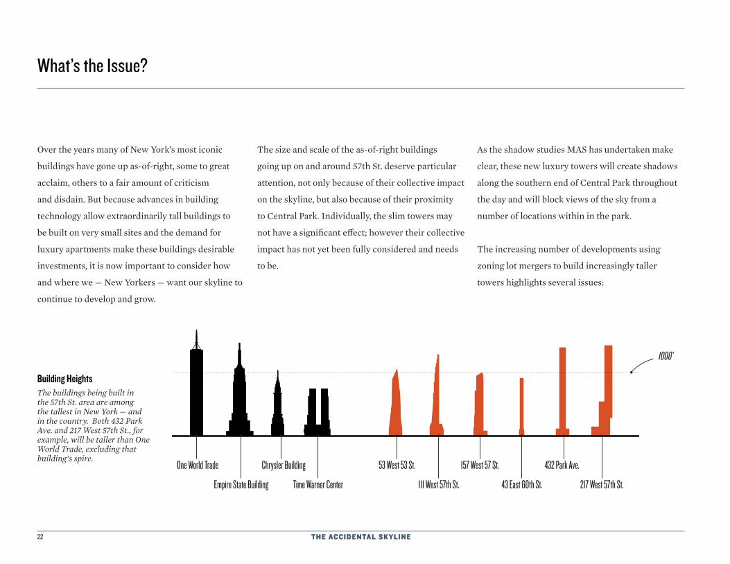
The size and scale of the as-of-right buildings
going up on and around 57th St. deserve particular
attention, not only because of their collective impact
on the skyline, but also because of their proximity
to Central Park. Individually, the slim towers may
not have a significant effect; however their collective
impact has not yet been fully considered and needs
to be.
What’s the Issue?
Building HeightsThe buildings being built in the 57th St. area are among the tallest in New York — and in the country. Both 432 Park Ave. and 217 West 57th St., for example, will be taller than One World Trade, excluding that building’s spire.
Empire State Building
Chrysler Building
Time Warner Center 111 West 57th St.
53 West 53 St.One World Trade
43 East 60th St. 217 West 57th St.
157 West 57 St. 432 Park Ave.
1000’
As the shadow studies MAS has undertaken make
clear, these new luxury towers will create shadows
along the southern end of Central Park throughout
the day and will block views of the sky from a
number of locations within in the park.
The increasing number of developments using
zoning lot mergers to build increasingly taller
towers highlights several issues:
THE ACCIDENTAL SKYLINE 23
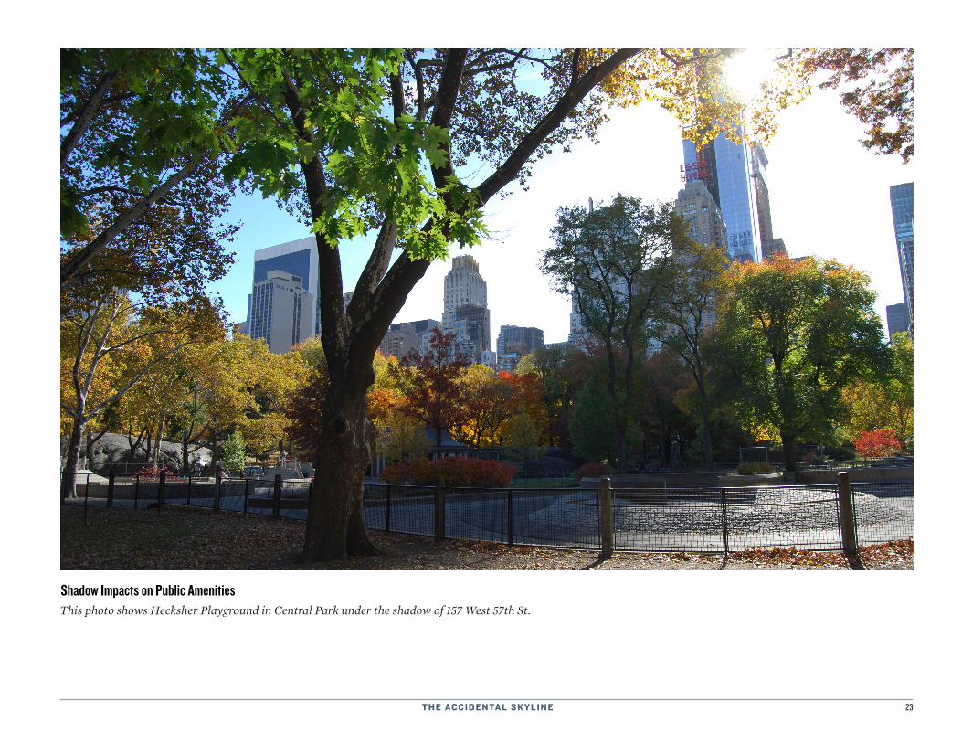
Shadow Impacts on Public AmenitiesThis photo shows Hecksher Playground in Central Park under the shadow of 157 West 57th St.
THE ACCIDENTAL SKYLINE24
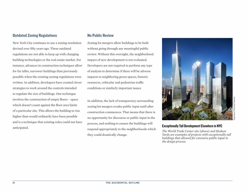
Exceptionally Tall Development Elsewhere in NYCThe World Trade Center site (above) and Hudson Yards are examples of projects with exceptionally tall buildings that allowed for extensive public input in the design process.
Outdated Zoning Regulations
New York City continues to use a zoning resolution
devised over fifty years ago. These outdated
regulations are not able to keep up with changing
building technologies or the real estate market. For
instance, advances in construction techniques allow
for far taller, narrower buildings than previously
possible when the existing zoning regulations were
written. In addition, developers have created clever
strategies to work around the controls intended
to regulate the size of buildings. One technique
involves the construction of empty floors – space
which doesn’t count against the floor area limits
of a particular site. This allows the building to rise
higher than would ordinarily have been possible
and is a technique that existing rules could not have
anticipated.
No Public Review
Zoning lot mergers allow buildings to be built
without going through any meaningful public
review. Without this oversight, the neighborhood
impact of new development is not evaluated.
Developers are not required to perform any type
of analysis to determine if there will be adverse
impacts to neighboring green spaces, historic
resources, vehicular and pedestrian traffic
conditions or similarly important issues.
In addition, the lack of transparency surrounding
zoning lot mergers evades public input until after
construction commences. That means that there is
no opportunity for discourse or public input in the
process, and nothing to ensure the buildings will
respond appropriately to the neighborhoods which
they could drastically change.
Imag
e Sou
rce: S
ilvers
tein P
ropert
ies
THE ACCIDENTAL SKYLINE 25
Unintended Consequences
Without regulatory requirements and a
comprehensive review of construction impacts,
view corridors, shadows, and other effects, the
community is left to live with the unknown
consequences of development.
Often during the City’s public review process, issues
regarding view corridors or height come up as areas
of concern and efforts to mitigate adverse impacts
may be negotiated with the developer. For instance,
when 53 West 53rd St. was evaluated by the City
Planning Commission, it was decided that “…the
applicant has not made a convincing argument that
the design of the tower’s top ... merits being in the
zone of the Empire State Building’s iconic spire,
making the building the second tallest building in
New York City.” The Commission then mandated
that the design be reduced 200 ft., resulting in a
tower of 1,050, instead of the 1,250 ft. originally
proposed.30 However, without public review,
extraordinarily tall buildings will go up unchecked
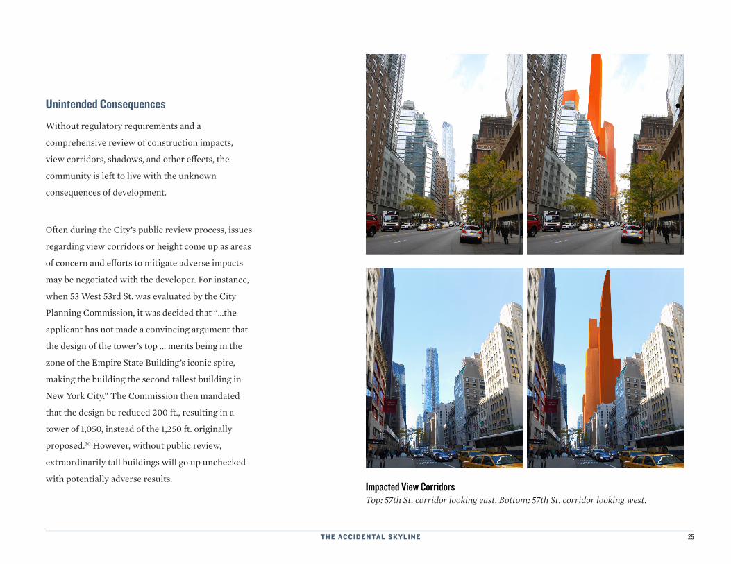
with potentially adverse results. Impacted View CorridorsTop: 57th St. corridor looking east. Bottom: 57th St. corridor looking west.
THE ACCIDENTAL SKYLINE26
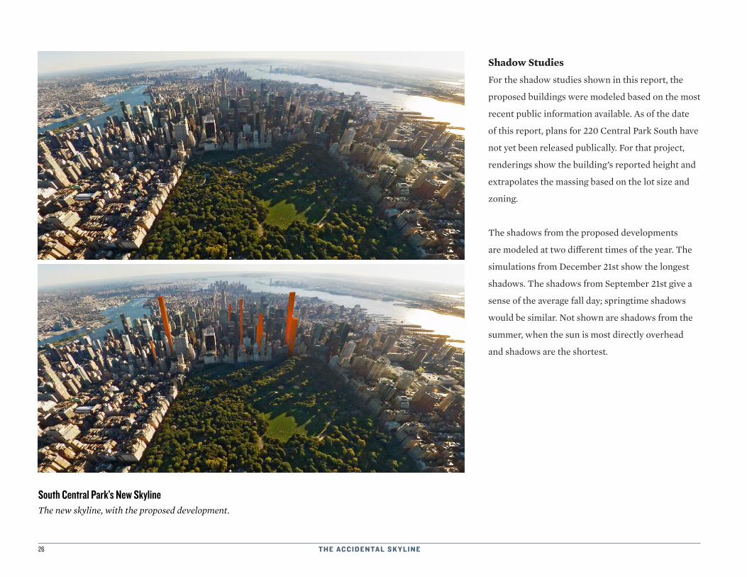
South Central Park’s New SkylineThe new skyline, with the proposed development.
Shadow Studies
For the shadow studies shown in this report, the
proposed buildings were modeled based on the most
recent public information available. As of the date
of this report, plans for 220 Central Park South have
not yet been released publically. For that project,
renderings show the building’s reported height and
extrapolates the massing based on the lot size and
zoning.
The shadows from the proposed developments
are modeled at two different times of the year. The
simulations from December 21st show the longest
shadows. The shadows from September 21st give a
sense of the average fall day; springtime shadows
would be similar. Not shown are shadows from the
summer, when the sun is most directly overhead
and shadows are the shortest.
THE ACCIDENTAL SKYLINE 27
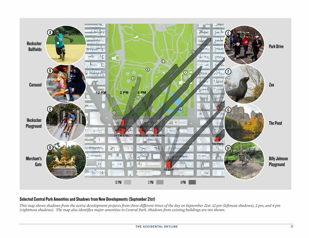
Selected Central Park Amenities and Shadows from New Developments (September 21st)This map shows shadows from the active development projects from three different times of the day on September 21st: 12 pm (leftmost shadows), 2 pm, and 4 pm (rightmost shadows). The map also identifies major amenities in Central Park. Shadows from existing buildings are not shown.
HeckscherBallfields Park Drive
Merchant’s Gate
Billy Johnson Playground
HeckscherPlayground The Pond
Carousel Zoo
D H
H
C G
B F
A
D
A
C
B
E
F
G
12 PM 2 PM 4 PM
WEST 60TH ST. EAST 60TH ST.
WEST 55TH ST. EAST 55TH ST.
5TH
AVE.
8TH
AVE.
WEST 65TH ST. EAST 65TH ST.
WEST 70TH ST. EAST 70TH ST.
E
THE ACCIDENTAL SKYLINE28
12 PM 2 PM 4 PM
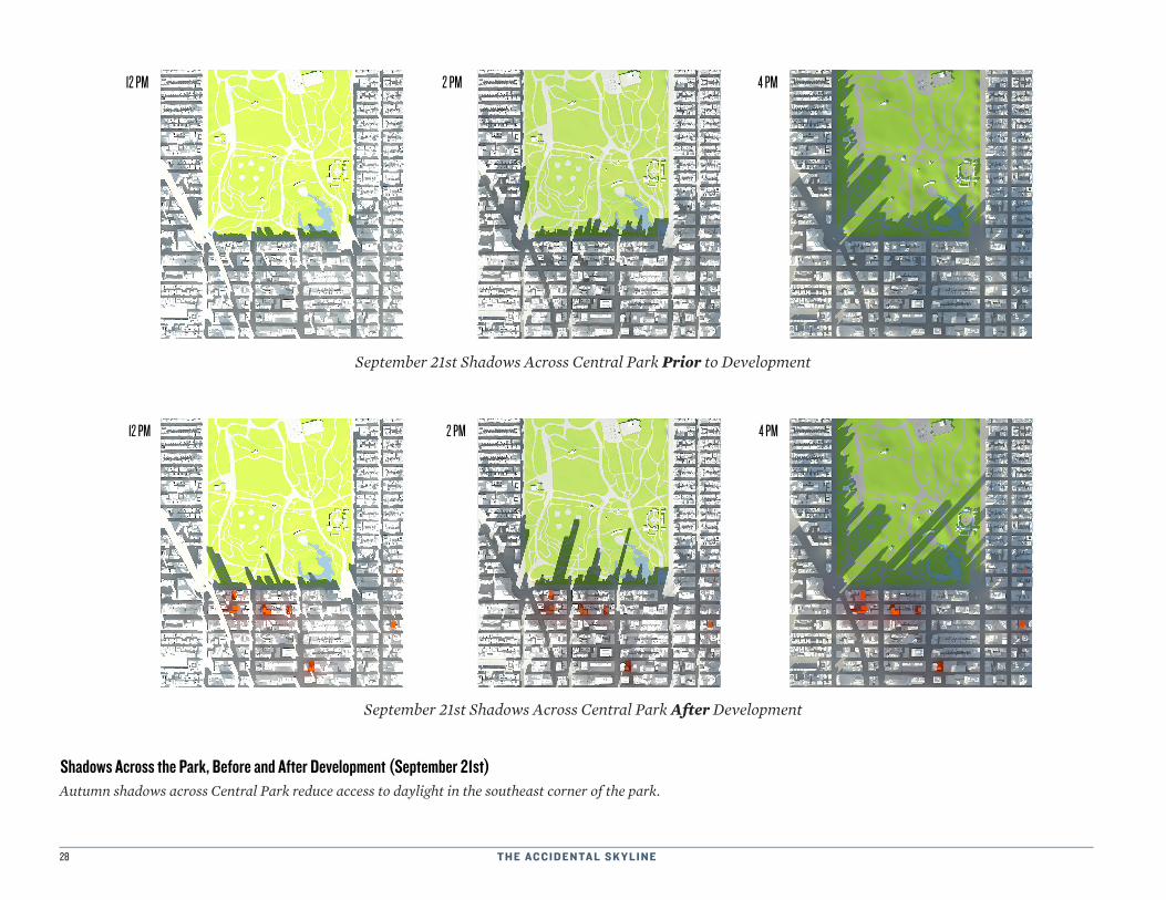
Towers Reduce Central Park’s Access to DaylightUNINTENDED CONSEQUENCES
Shadows Across the Park Prior to Development
AUTUMN SHADOWS Autumn shadows across central park reduce access to daylight in the South-East corner of the Park.September 21st is used for the purpose of this study.
Shadows Across the Park, Before and After Development (September 21st)Autumn shadows across Central Park reduce access to daylight in the southeast corner of the park.
2 PM
12 PM 2 PM 4 PM
Towers Reduce Central Park’s Access to DaylightUNINTENDED CONSEQUENCES
Shadows Across the Park After Development
AUTUMN SHADOWS Autumn shadows across central park reduce access to daylight in the South-East corner of the Park.September 21st is used for the purpose of this study.
2 PM 4 PM
4 PM
September 21st Shadows Across Central Park Prior to Development
September 21st Shadows Across Central Park After Development
12 PM
12 PM
THE ACCIDENTAL SKYLINE 29
Towers Reduce Central Park’s Access to DaylightUNINTENDED CONSEQUENCES
Shadows Across the Park Prior to Development
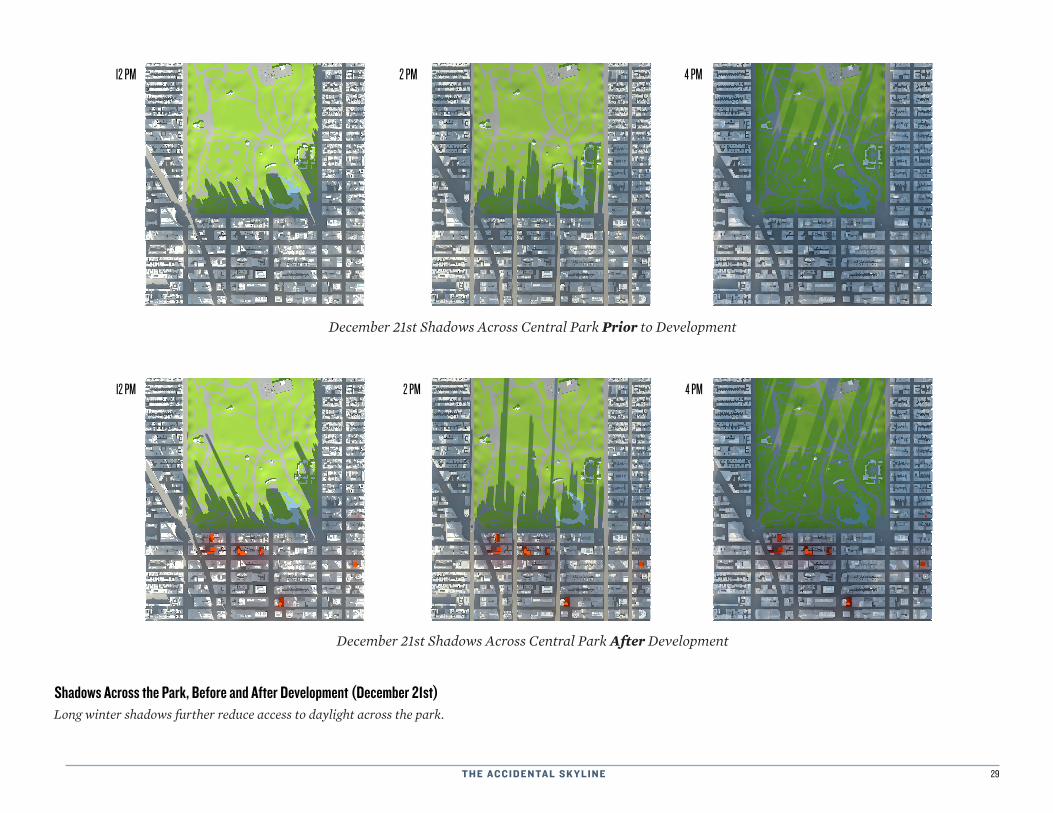
December 12 PM December 2 PM December 3 PM
WINTER SHADOWS Long winter shadows further reduce access to daylight across the Park. December 21st is used for the purpose of this study.
Shadows Across the Park, Before and After Development (December 21st)
December 21st Shadows Across Central Park Prior to Development
December 21st Shadows Across Central Park After Development
Long winter shadows further reduce access to daylight across the park.
2 PM12 PM
WINTER SHADOWS
December 12 PM December 2 PM
Towers Reduce Central Park’s Access to DaylightUNINTENDED CONSEQUENCES
Shadows Across the Park After Development
Long winter shadows further reduce access to daylight across the Park. December 21st is used for the purpose of this study.
December 3 PM
2 PM12 PM 4 PM
4 PM
THE ACCIDENTAL SKYLINE30
The solution is not to landmark or preserve the
jagged silhouette of buildings along the southern
edge of Central Park, but to find a way to ensure that
the park is protected and the best possible buildings
are built. A re-thinking of our regulations and a re-
balancing of priorities is needed in order to protect
the experience of the park for millions of visitors
over the views of a handful.
Central Park, and the city’s other open spaces, are
critical to the economic health of New York City
and to the well-being of its residents. The value of
protecting these open spaces over the long term
far exceeds the value a handful of new buildings
will bring to the city. The Special West Chelsea
District was created to support the development
of the High Line and is an example of an urban
design framework where the size and shape of
buildings are designed in response to an open space.
A re-appraisal of our zoning today around our key
open spaces is needed to ensure that we carefully
consider the impacts of New York’s growth.
Based on the shadow studies MAS has produced, it
is clear that the existing regulations do not
sufficiently protect Central Park nor do they provide
a predictable framework for guiding development.
The existing regulations are producing buildings
that have caught the public off guard and have
surprised regulators. Many other cities such as
Boston and San Francisco have developed zoning
rules which more carefully consider the impact of
development on open space. New York City could
follow suit.
A variety of different approaches require further
study and investigation but it is clear that the status
quo is eroding the quality of one of the world’s most
treasured open spaces. Although the problem today
centers around Central Park, the challenge should
be understood as a citywide question of how to
permit growth while protecting the qualities that
make New York unique.
Starting a Conversation
We hope this study initiates a broad conversation,
involving developers, City officials, and community
stakeholders, that will generate creative and
collaborative solutions to New York’s development
issues.
The Departments of Buildings and City Planning
should also establish a process to ensure that if
any new super-tall building permits are filed, these
applications can be evaluated more carefully and
quickly. This will help inform decision making
about needed zoning changes.
The City should also explore any legal measures
which would allow it more time to study these
issues in greater depth.
Potential Solutions
THE ACCIDENTAL SKYLINE 31
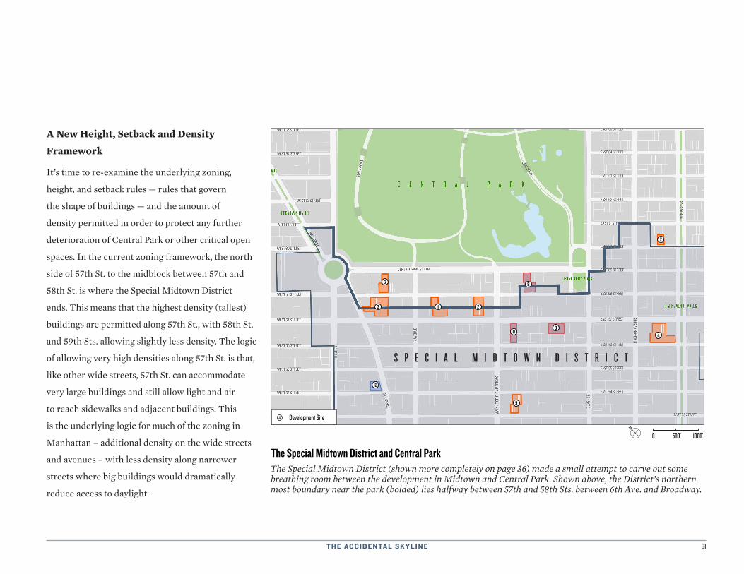
A New Height, Setback and Density
Framework
It’s time to re-examine the underlying zoning,
height, and setback rules — rules that govern
the shape of buildings — and the amount of
density permitted in order to protect any further
deterioration of Central Park or other critical open
spaces. In the current zoning framework, the north
side of 57th St. to the midblock between 57th and
58th St. is where the Special Midtown District
ends. This means that the highest density (tallest)
buildings are permitted along 57th St., with 58th St.
and 59th Sts. allowing slightly less density. The logic
of allowing very high densities along 57th St. is that,
like other wide streets, 57th St. can accommodate
very large buildings and still allow light and air
to reach sidewalks and adjacent buildings. This
is the underlying logic for much of the zoning in
Manhattan – additional density on the wide streets
and avenues – with less density along narrower
streets where big buildings would dramatically
reduce access to daylight.
1000’
0 500’ 1000’
N
1 2
5
8
911
12
3
4
6
7
Development Site#
The Special Midtown District and Central ParkThe Special Midtown District (shown more completely on page 36) made a small attempt to carve out some breathing room between the development in Midtown and Central Park. Shown above, the District’s northern most boundary near the park (bolded) lies halfway between 57th and 58th Sts. between 6th Ave. and Broadway.
S P E C I A L M I D T O W N D I S T R I C T
THE ACCIDENTAL SKYLINE32
Unfortunately this framework that permits very
high densities on 57th St. does not do enough
to protect Central Park. A height and setback
framework which seeks to minimize any impact
on the park needs to be more carefully examined.
Instead of a simple height limit, a performance-
based approach should be used to evaluate how
much a particular building or collection of buildings
will impact the park.
Public Review
Applications for new buildings which will cast a
shadow on the park should be submitted to the
affected community boards and require the City
Planning Commission to conduct a hearing with
input from the Parks Department. The Commission
should be given the power to disapprove the
issuance of a permit if it finds that the proposed
project will have any significant impact on the use of
the park because of the shading or shadowing that
it will cause. There should also be an opportunity
to consider mitigation measures which might help
offset the loss of sunlight and improve the park.
Similarly, some level of design review for a building
which seeks to break through the forest of buildings
and enter the skyline should be considered. This
height trigger should be carefully calibrated to
respond to the neighborhood context.
In addition, if a developer is assembling more than
20% above what the development footprint allows,
this could also trigger a form of public review. For
instance, if a particular site can accommodate a
building of 100,000 square ft. based on the zoning
for that site and the developer purchases more than
20,000 square ft. of air rights (more than 20%) from
surrounding sites, then that building could trigger
public review to evaluate the appropriateness of
additional density.
Improving Transparency
Many of these developments have been assembled
over the years through the purchase of development
rights from adjacent buildings. As has been pointed
out by the Furman Center’s report, Buying Sky:
The Market for Transferable Development Rights in
New York City, the challenge for the public and for
regulators is that these transactions are very difficult
to track. Zoning lot mergers and the purchase of
air rights should be filed with the Department of
Finance, in addition to the Department of City
Planning and Department of Buildings, and be
referred to the relevant community board and
elected officials. This will allow the public, elected
officials and regulators the opportunity to track
development and to make more timely policy
decisions in response to development trends.
THE ACCIDENTAL SKYLINE 33
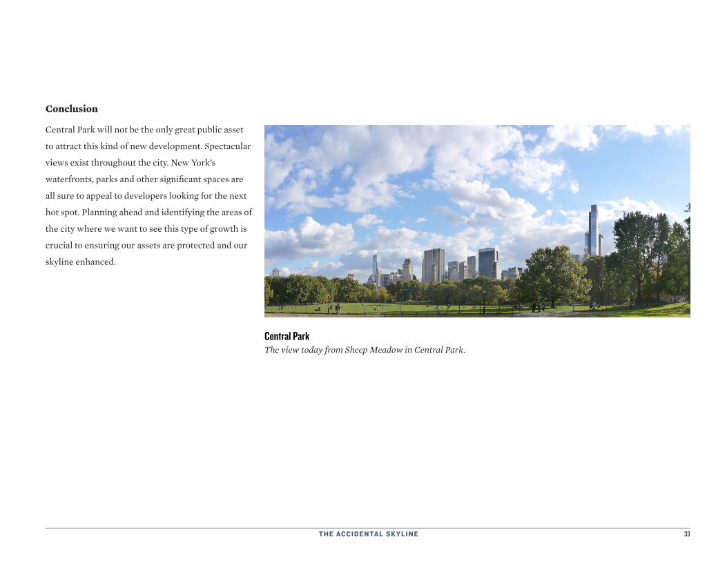
Conclusion
Central Park will not be the only great public asset
to attract this kind of new development. Spectacular
views exist throughout the city. New York’s
waterfronts, parks and other significant spaces are
all sure to appeal to developers looking for the next
hot spot. Planning ahead and identifying the areas of
the city where we want to see this type of growth is
crucial to ensuring our assets are protected and our
skyline enhanced.
Central ParkThe view today from Sheep Meadow in Central Park.
THE ACCIDENTAL SKYLINE34
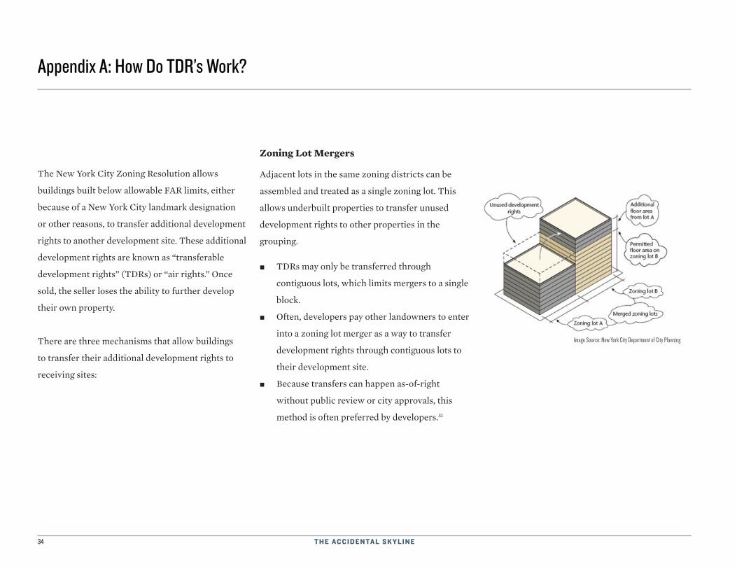
The New York City Zoning Resolution allows
buildings built below allowable FAR limits, either
because of a New York City landmark designation
or other reasons, to transfer additional development
rights to another development site. These additional
development rights are known as “transferable
development rights” (TDRs) or “air rights.” Once
sold, the seller loses the ability to further develop
their own property.
There are three mechanisms that allow buildings
to transfer their additional development rights to
receiving sites:
Zoning Lot Mergers
Adjacent lots in the same zoning districts can be
assembled and treated as a single zoning lot. This
allows underbuilt properties to transfer unused
development rights to other properties in the
grouping.
ȕ TDRs may only be transferred through
contiguous lots, which limits mergers to a single
block.
ȕ Often, developers pay other landowners to enter
into a zoning lot merger as a way to transfer
development rights through contiguous lots to
their development site.
ȕ Because transfers can happen as-of-right
without public review or city approvals, this
method is often preferred by developers.31
Image Source: New York City Department of City Planning
Appendix A: How Do TDR’s Work?
THE ACCIDENTAL SKYLINE 35
Image Source: New York City Department of City Planning
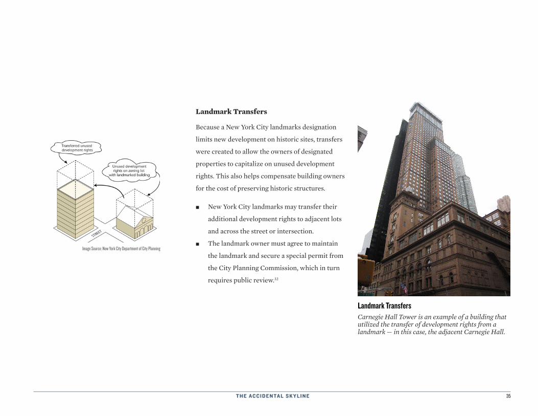
Landmark Transfers
Because a New York City landmarks designation
limits new development on historic sites, transfers
were created to allow the owners of designated
properties to capitalize on unused development
rights. This also helps compensate building owners
for the cost of preserving historic structures.
ȕ New York City landmarks may transfer their
additional development rights to adjacent lots
and across the street or intersection.
ȕ The landmark owner must agree to maintain
the landmark and secure a special permit from
the City Planning Commission, which in turn
requires public review.32
Landmark TransfersCarnegie Hall Tower is an example of a building that utilized the transfer of development rights from a landmark — in this case, the adjacent Carnegie Hall.
THE ACCIDENTAL SKYLINE36
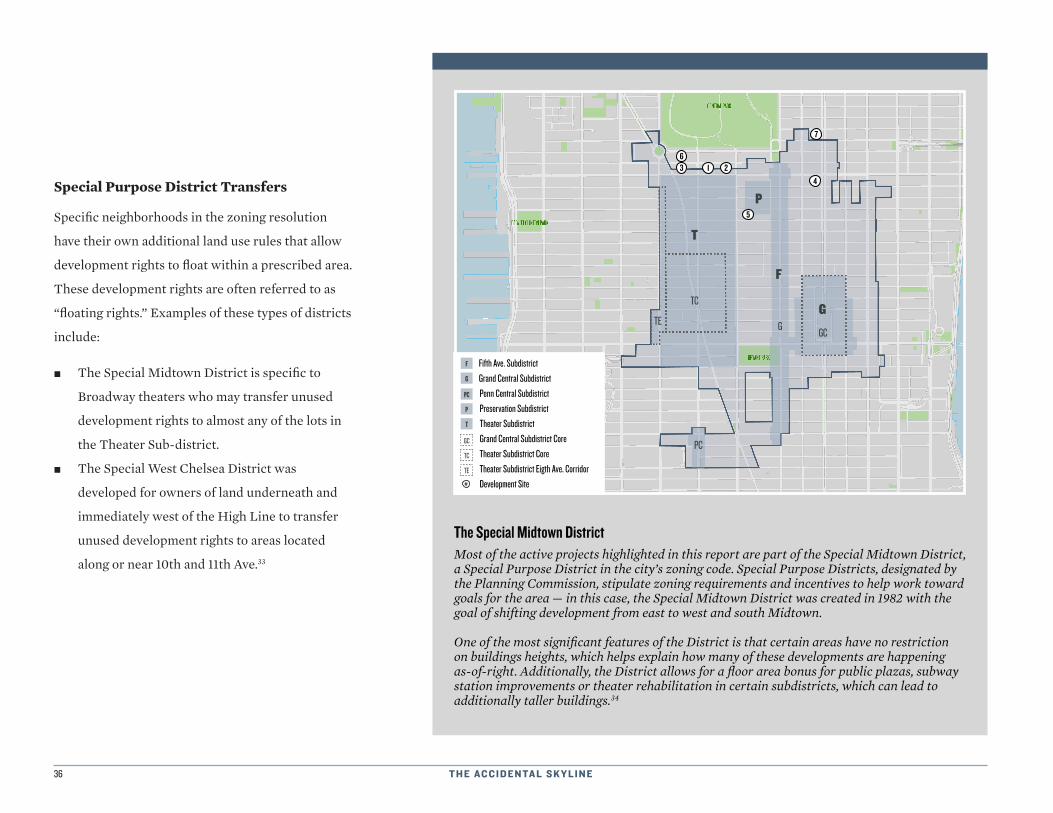
The Special Midtown DistrictMost of the active projects highlighted in this report are part of the Special Midtown District, a Special Purpose District in the city’s zoning code. Special Purpose Districts, designated by the Planning Commission, stipulate zoning requirements and incentives to help work toward goals for the area — in this case, the Special Midtown District was created in 1982 with the goal of shifting development from east to west and south Midtown.
One of the most significant features of the District is that certain areas have no restriction on buildings heights, which helps explain how many of these developments are happening as-of-right. Additionally, the District allows for a floor area bonus for public plazas, subway station improvements or theater rehabilitation in certain subdistricts, which can lead to additionally taller buildings.34
1 2
5
34
6
7
Special Purpose District Transfers
Specific neighborhoods in the zoning resolution
have their own additional land use rules that allow
development rights to float within a prescribed area.
These development rights are often referred to as
“floating rights.” Examples of these types of districts
include:
ȕ The Special Midtown District is specific to
Broadway theaters who may transfer unused
development rights to almost any of the lots in
the Theater Sub-district.
ȕ The Special West Chelsea District was
developed for owners of land underneath and
immediately west of the High Line to transfer
unused development rights to areas located
along or near 10th and 11th Ave.33
PC
TC
TE
Development SiteTheater Subdistrict Eigth Ave. CorridorTheater Subdistrict CoreGrand Central Subdistrict Core
Preservation SubdistrictTheater Subdistrict
Penn Central SubdistrictGrand Central SubdistrictFifth Ave. Subdistrict
#
TE
T
G
TC
P
F
GC
PC
P
T
F
G
GCG
THE ACCIDENTAL SKYLINE 37
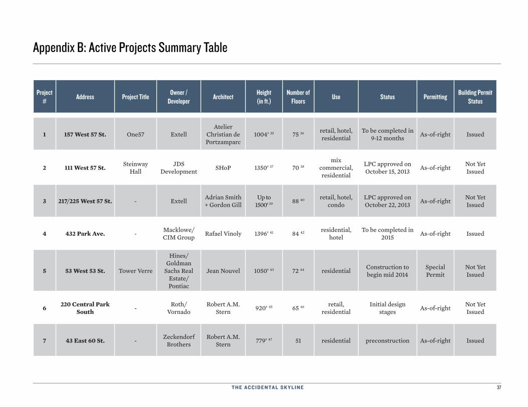
Project #
Address Project TitleOwner /
DeveloperArchitect
Height(in ft.)
Number of Floors
Use Status PermittingBuilding Permit
Status
1 157 West 57 St. One57 ExtellAtelier
Christian de Portzamparc
1004’ 35 75 36 retail, hotel, residential
To be completed in 9-12 months As-of-right Issued
2 111 West 57 St. Steinway Hall
JDS Development SHoP 1350’ 37 70 38
mix commercial, residential
LPC approved on October 15, 2013 As-of-right Not Yet
Issued
3 217/225 West 57 St. - Extell Adrian Smith + Gordon Gill
Up to 1500’ 39 88 40 retail, hotel,
condoLPC approved on October 22, 2013 As-of-right Not Yet
Issued
4 432 Park Ave. - Macklowe/CIM Group Rafael Vinoly 1396’ 41 84 42 residential,
hotelTo be completed in
2015 As-of-right Issued
5 53 West 53 St. Tower Verre
Hines/Goldman
Sachs Real Estate/Pontiac
Jean Nouvel 1050’ 43 72 44 residential Construction to begin mid 2014
Special Permit
Not Yet Issued
6 220 Central Park South - Roth/
VornadoRobert A.M.
Stern 920’ 45 65 46 retail, residential
Initial design stages As-of-right Not Yet
Issued
7 43 East 60 St. - Zeckendorf Brothers
Robert A.M. Stern 779’ 47 51 residential preconstruction As-of-right Issued
Appendix B: Active Projects Summary Table
THE ACCIDENTAL SKYLINE38
Endnotes
1. For a complete list of sources on the height of the buildings shown in this image, see the sources for the table on page 37.
2. Jackson, Kenneth (Ed.). The Encyclopedia of New York City. New Haven: Yale University Press. 1995.
3. Stern, R., Mellins, T. & Fishman, D. New York 1960: Architecture and Urbanism Between the Second World War and the Bicentennial. New York: The Monacelli Press. 1995.
4. Stern, R., Fishman, D. & Tilove, J. New York 2000. New York: The Monacelli Press. 2006.
5. Stern, R., Mellins, T. & Fishman, D. New York 1960: Architecture and Urbanism Between the Second World War and the Bicentennial. New York: The Monacelli Press. 1995.
6. Gilmartin, Gregory. Shaping the City: New York and the Municipal Art Society. New York: Clarkson Potter. 1995. p. 464; Stern. 2006.
7. Kaufman, Edgar. (Ed.). The Rise of an American Architecture. New York: Praeger Publishers. 1970.
8. Stern, R., Mellins, T. & Fishman, D. New York 1880: Architecture and Urbanism in the Gilded Age. New York: The Monacelli Press. 1999.
9. Matlins, Melissa. “World Building.” Retrieved from http://www.skyscraper.org/TALLEST_TOWERS/t_world.htm.
10. The New York City Landmarks Preservation Commission. Designation Report of The Woolworth Building. New York. April 12, 1983.
11. Jackson, K. (Ed.). (1995). The Encyclopedia of New York City. New Haven: Yale University Press.
Sources
12. The New York City Landmarks Preservation Commission. Designation Report of The Chrysler Building. New York. September 12, 1978.
13. The Skyscraper Museum. “Tall But Not Slender.” http://www.skyscraper.org/EXHIBITIONS/SKY_HIGH/nw_00intro.php. Accessed on December 7, 2013.
14. Bagli, Charles. “Sky High and Going Up Fast: Luxury Towers Take New York.” The New York Times. May 18, 2013.
15. Pincus, Adam. “More One57 buyers revealed — several are apparel magnates.” The Real Deal. July 24, 2013. http://therealdeal.com/blog/2013/07/24/more-one57-buyers-revealed-and-several-are-apparel-magnates/ Direct link to source: http://therealdeal.com/wp-content/uploads/2013/07/157W57-Sch-A-chart_4.pdf.
16. Ibid.17. Dharmarajan, Sheila. “Tall And Slender: The
World’s Skinniest Skyscraper.” Yahoo News. November 4, 2013.
18. Ibid.19. “1,440 or 1,500 ft.” is listed in Bagli, Charles.
“Developers End Fight Blocking 2 More Luxury Towers in Midtown.” The New York Times. October 15, 2013. The New York City Department of Buildings files lists the building at 1550 ft..
20. Brown, Eliot. “Deal Settles Dispute Between Extell, Vornado: Developers to Proceed With Condo Towers Overlooking Central Park.” The Wall Street Journal. October 15, 2013.
21. “432 Park Avenue.” The Skyscraper Center: The Global Tall Building Database of the CTBUH. http://www.skyscrapercenter.com/building.php?building_id=13227.
22. Karmin, Craig. “Park Avenue Condo Tower Approaches $1 Billion in Sales.” The Wall Street Journal. October 4, 2013.
23. Hines. “Hines and Goldman Sachs Partner with Pontiac Land on High-Profile Residential Project Including MoMA Expansion.” Press release. October 30, 2013. http://www.hines.com/press/releases/10-30-13.aspx
24. Brown, E. October 15, 2013.25. Ibid.26. Bagli, Charles. “$40 Million in Air Rights Will
Let East Side Tower Soar.” The New York Times. February 25, 2013.
27. New York Department of Finance. “Zoning Lot Development and Reciprocal Easements Agreement by and between Broadway Trio, LLC and Broadway 57th/58th Retail Investor, LLC.” July 22, 2013.
28. Ibid.29. Ibid (for all numbers in table).30. New York City Department of City Planning. “53
West 53rd Street/MoMA, ‘lead’ report.” September 9, 2009. http://www.nyc.gov/html/dcp/pdf/cpc/090432.pdf.
31. Furman Center for Real Estate and Urban Policy. Buying Sky: The Market for Transferable Development Rights in New York City. New York University School of Law and the Robert F. Wagner Graduate School of
THE ACCIDENTAL SKYLINE 39
Central Park Amenities Images (page 27):Hecksher Ballfields: Flickr user aherrero. Original: http://
www.flickr.com/photos/10414027@N02/6158556913/Carousel: Flickr user comedy_nose. Original: http://www.
flickr.com/photos/23408922@N07/4162853637/Heckscher Playground: Flickr user Elton lin. Original: http://
www.flickr.com/photos/96545415@N00/Merchant’s Gate: Flickr user rbglasson. Original: http://www.
flickr.com/photos/37835538@N00/4290637618/Park Drive: Flickr user smith_cl9. Original: http://www.flickr.
com/photos/24415055@N00/5565688278/Zoo: Flickr user -JvL-. Original: http://www.flickr.com/
photos/-jvl-/6074646303/The Pond: Flickr user Ed Yourdon. Original: http://www.
flickr.com/photos/72098626@N00/4085346513/Billy Johnson Playground: The Cultural Landscape
Foundation. Original: http://tclf.org/landscapes/east-67th-street-playground-billy-johnson-playground/
Landmark Transfer (page 35): Flickr user thisisjohndevon. Original: http://www.flickr.
com/photos/8900930@N06/1296075098/
Public Service. October 2013.32. Ibid.33. Ibid.34. New York City Department of City Planning. “Zoning
Districts: Special Districts.” http://www.nyc.gov/html/dcp/html/zone/zh_special_purp_mn.shtml.
35. New York City Department of Finance. July 2013.36. Extell and Adrian Smith+Gordon Gill. “Certificate of
Appropriateness Application.” October 1, 2013. 37. SHoP Architects. “Steinway Building and West 57th
Street.” Presentation to the Landmarks Preservation Commission. Septmber 2013.
38. Ibid.39. Bagli. February 25, 2013.40. New York City Department of Buildings.41. Macklowe. http://www.432parkavenue.com/42. Ibid.43. Hines. October 2013.44. Hines. October 2013.45. Brown. October 2013.46. Brown. October 2013.47. New York City Department of Buildings.
Maps and Data Sources
NYC Open Data. Department of Information Technology and Telecommuncations. https://nycopendata.socrata.com
New York City Department of City Planning. Bytes of the Big Apple. http://www.nyc.gov/html/dcp/html/bytes/applbyte.shtml. Access August 2013. Main data source: MapPluto 13v1.
Additional Photo and Image Sources
Skyscrapers and the Changing Shape of the City (pages 13):New York World Building: Wikimedia Commons. Original:
http://commons.wikimedia.org/wiki/File:Newspaper_Row,_1906.JPG
The Singer Building: Library of Congress. Original: http://www.loc.gov/pictures/item/ny0428/
The Woolworth Building: Library of Congress. Original: http://www.loc.gov/pictures/resource/cph.3c27214/
The Equitable Building: Library of Congress. Original: http://www.loc.gov/pictures/resource/cph.3b11747/
The Chrysler Building: Library of Congress. Original: http://www.loc.gov/pictures/resource/ppmsca.05841/
Rockefeller Center: Libary of Congress. Original: http://www.loc.gov/pictures/resource/ppmsca.05853/
The Empire State Building: Library of Congress. Original: http://www.loc.gov/pictures/resource/highsm.16898/
The World Trade Center: Library of Congress. Original: http://hdl.loc.gov/loc.pnp/highsm.12368
One World Trade Center: Flickr user Joe Mabel. Original: http://www.flickr.com/photos/7943225@N02/9440051011/
South Central Park’s New Skyline (page 26): AirPano.com
THE ACCIDENTAL SKYLINE40
Richard Bass
Jerome Deutsch
William Donohoe
Kenneth Fisher
John Fontillas
Ellen Joseph
Eric Lee
Lois Mazzitelli
Stuart Pertz
Zevilla J. Preston
Nicholas Quennell
Stephen M. Raphael
Brendan Sexton
Ethel Sheffer
John Shapiro
John West
Angel Ayon
Norma Barbacci
Laurie Beckelman
Francis Booth
Ward S. Dennis
Mary B. Dierickx
Andrew S. Dolkart
Franny Eberhart
Renee C. Epps
Scott Francisco
Harold Fredenburgh
Joan H. Geismar
Michael George
Isabel Hill
Diane S. Kaese
Sophia Koven
Jeffrey Kroessler
Roberta Lane
Ken Lustbader
Jonathan Marvel
Christopher Neville
Richard Olcott
Otis Pratt Pearsall, Esq.
Jean Parker Phifer
Chair
Eugenie L. Birch
President
Vin Cipolla
Vice Chair
Susan K. Freedman
Treasurer
James M. Clark, Jr.
Secretary
Frances A. Resheske
General Counsel
Earl D. Weiner, Esq.
Enid L. Beal
Vicki Been
Paul R. Beirne
Elizabeth Belfer
Serena Boardman
Gabriel Calatrava
Lisa Smith Cashin
Kathryn C. Chenault, Esq.
Michael P. Donovan
Kitty Hawks
Daniel Hernandez
Michael B. Hoffman
Frederick Iseman
Sophia Koven
David W. Levinson
Julie Menin
Gregory Morey
Julio Peterson
Carlos Pujol
Janet C. Ross
David F. Solomon
Jerry I. Speyer
Kent M. Swig
Yeohlee Teng
Alison Tocci
Thomas Vecchione
Thomas L. Woltz
William H. Wright, II
Gary J. Zarr
Charles Platt
Nina Rappaport
Roxanne Ryce-Paul
Judith Saltzman
Frank Sanchis
Roy Strickland
Susan Tunick
Kevin Wolfe
Gwendolyn Wright
J. Mike Zee
MAS Preservation Committee MAS Planning CommitteeMAS Board of Directors
Acknowledgments
Ronda Wist
Raju Mann
Mike Ernst
Aileen Gorsuch
Lakan Cole
Mark Hendricks
MAS Staff
41
The Municipal Art Society of New York has
led New York City’s livability movement
since 1893. MAS’s mission is to advocate
for public policies, private sector practices,
individual agency and community
engagement for a resilient built environment
that encourages our city’s economic
vitality, cultural vibrancy, environmental
sustainability, livability and social diversity.
For more information, visit mas.org.