Buck Regulator Architectures 4.3 Hysteretic Buck Regulators.
Indiana Department of Transportation
Access Management Guide
Prepared by:AECOM Transportation
In association with:Bernardin Lochmueller and Associates, Inc.
August 2006Revised: September 2009
G:\207075 (INDOT Access Management 2)\500 - Deliverables\FINAL DELIVERABLES\Access Management Guide - revised\SourceDocuments\INDOT Access Management Guide_FINAL - Revised Sept 2009.doc

September 2009INDOT Access Management Guide – REVISED Indiana Department of Transportation
AECOM Transportation New York, New Yorki
ACKNOWLEDGEMENTS
The following individuals were instrumental in the development, review, and refinement of materialsincluded in this Guide. We greatly appreciate the time and contributions of the following Study AdvisoryCommittee members, particularly those who provided supplemental information.
INDOT Project Manager
Stephen C. SmithIndiana Department of Transportation
Long-Range Transportation Planning SectionIndianapolis, IN
Advisory Committee: Phase 2 (2007-2009)
Kent AndersonColumbus Area Metropolitan Planning Organization
Columbus, IN
Randy ArcherIndiana Department of Transportation
Vincennes District OfficeIndianapolis, IN
Dan AveryNortheastern Indiana Regional Coordinating Council
Allen County, IN
Glen BoiseKokomo/Howard County Planning Commission
Kokomo, IN
Jerry BridgesMadison County Council of Governments
Anderson, IN
Daniel G. BuckIndiana Department of Transportation
Long-Range Transportation Planning SectionIndianapolis, IN
Carolyn CoffinIndiana Department of Transportation
Greenfield District OfficeIndianapolis, IN
Bob DemuthIndiana Department of Transportation
Indianapolis, IN
Bill DittrichIndiana Department of Transportation
Indianapolis, IN
September 2009INDOT Access Management Guide – REVISED Indiana Department of Transportation
AECOM Transportation New York, New Yorkii
George DremonasIndiana Department of Transportation
Indianapolis, IN
Khalil DughaishIndiana Department of Transportation
Vincennes District OfficeIndianapolis, IN
Bill FloraIndiana Department of Transportation
Long-Range Transportation Planning SectionIndianapolis, IN
Brian HarveyIndiana Department of Transportation
Standards SectionIndianapolis, IN
Mike HolowatyIndiana Department of Transportation
Indianapolis, IN
David HoltzIndiana Department of Transportation
Indianapolis, IN
Karl LeetIndiana Department of Transportation
Indianapolis, IN
Travis MankinIndiana Department of Transportation
Indianapolis, IN
Jay MitchellIndiana Department of Transportation
Long-Range Transportation Planning SectionIndianapolis, IN
Dwane E. MyersIndiana Department of Transportation
Greenfield District OfficeGreenfield, IN
Roy NunnallyIndiana Department of Transportation
Modeling SectionIndianapolis, IN
Jim OlsonJefferson County Highway Department
Madison, IN

September 2009INDOT Access Management Guide – REVISED Indiana Department of Transportation
AECOM Transportation New York, New Yorkiii
Ryan SmithMadison County Council of Governments
Anderson, IN
Richard VanCleaveIndiana Department of Transportation
Standards SectionIndianapolis, IN
Advisory Committee: Phase 1 (2004-2006)
Kent AndersonColumbus Area Metropolitan Planning Organization
Columbus, IN
Glen BoiseKokomo/Howard County Planning Commission
Kokomo, IN
Jerry BridgesMadison County Council of Governments
Anderson, IN
Daniel G. BuckIndiana Department of Transportation
Long-Range Transportation Planning SectionIndianapolis, IN
Brian HarveyIndiana Department of Transportation
Standards SectionIndianapolis, IN
Eryn HaysIndiana Department of Transportation
Long-Range Transportation Planning SectionIndianapolis, IN
Deborah LuzierWilbur Smith Associates
Indianapolis, IN
Dwane E. MyersIndiana Department of Transportation
Greenfield District OfficeGreenfield, IN
John NagleIndiana Department of Transportation
Management Systems SectionIndianapolis, IN
Jim OlsonJefferson County Highway Department
Madison, IN

September 2009INDOT Access Management Guide – REVISED Indiana Department of Transportation
AECOM Transportation New York, New Yorkiv
Steve PenturfIndiana Department of Transportation
Office of Real EstateIndianapolis, IN
Ed RatulowskiFederal Highway Administration
Indianapolis, IN
Robert ReblingIndiana Department of Transportation
Greenfield District OfficeGreenfield, IN
Greg RichardsIndiana Department of Transportation
Engineering Assessment SectionIndianapolis, IN
Brad StecklerIndiana Department of Transportation
Engineering Assessment SectionIndianapolis, IN
Ken WoodruffFederal Highway Administration
Indianapolis, IN
Report Authors
Jerome GluckAECOM Transportation
New York, NY
Matthew LorenzAECOM Transportation
New York, NY
Consultant Team Members
David RippleBernardin Lochmueller & Associates, Inc.
Evansville, IN
Frank KoepkeS/K Transportation Consultants
Hillsborough, NC
David RoseDye Management Group
Bellevue, WA
Herbert S. LevinsonNew Haven, CT

September 2009INDOT Access Management Guide – REVISED Indiana Department of Transportation
AECOM Transportation New York, New Yorkv
Debra M. Simmons-WilsonEngaging Solutions
Indianapolis, IN
James MosleyEnviroKineticsNewburgh, IN
September 2009INDOT Access Management Guide – REVISED Indiana Department of Transportation
AECOM Transportation New York, New Yorkvi
PREFACE
This Guide presents and explains how and when to use a wide-range of access management techniques toaddress common traffic and access-related problems. Access management is a set of proven techniquesthat can help reduce traffic congestion, reduce the frequency of crashes, maintain the existing roadwaycapacity, and preserve investment in roads by managing the location, design and type of access toproperty. By preserving the flow of traffic and improving traffic safety, access management helps toencourage economic growth.
Purposes of the Guide
This Guide is intended as both a reference manual for INDOT District and Central Office Permits staff, aswell as an informational resource for elected and appointed local government officials, planners, and roadauthority personnel. The Guide is based on the growing recognition that many transportation operationsand safety benefits are achieved through local, county, regional, and state cooperation in solving existingtransportation problems, and preventing future ones. By raising awareness of the planning, design, andregulatory techniques applied in effective access management among local, county, regional and stateofficials, better communication and success in the pursuit of common transportation and land useobjectives could be achieved. Chief among these common objectives is the prevention of needless deathsand injury caused by poor access design. Good access design also prevents traffic crashes, improvesroadway performance, and preserves the public investment in our roadways.
There are six principal purposes of this Guide:
1. Identify and explain the role and benefits of access management in contributing to solutions tocommon traffic problems.
2. Present a set of access management principles to serve as a foundation for effective accessmanagement techniques on both developed and developing corridors.
3. Provide a description of effective access management techniques for a wide variety ofsituations.
4. Identify the steps to prepare an access management plan and access management regulationsby local governments in Indiana.
5. Describe the desired relationship between the Indiana Department of Transportation (INDOT)and local governments on access management issues.
6. Describe how Guide readers can make a difference on common access management issues intheir own communities.
Organization of the Guide
This Guide presents access management techniques designed to help address common traffic problems.These techniques are organized around 15 access management principles listed in Section 1.3. Fewaccess-related traffic problems can be solved with a simple “quick fix”. Typically, many techniques mustbe used together as part of a coordinated set of long range initiatives to achieve the desired result.Similarly, most principles and many techniques are interrelated. This interrelationship is evident with thereferences to multiple techniques for nearly every question presented at the start of Section 1.1 and themultiple cross-references throughout the Guide.

September 2009INDOT Access Management Guide – REVISED Indiana Department of Transportation
AECOM Transportation New York, New Yorkvii
Contacting INDOT regarding the Guide
As noted in the Acknowledgements, the materials in this Guide were prepared with considerable guidancefrom a large number of local, state, and other stakeholders. The Guide is intended to meet a wide rangeof user needs. Research regularly contributes to refining various access management techniques. Stateand national guidelines sometimes change. Local officials unfamiliar with the access managementtechniques in this guidebook may require more information or clarification. Please contact INDOT if youwish to get more information, to suggest an improvement to the Guide or to order additional copies.

September 2009INDOT Access Management Guide – REVISED Indiana Department of Transportation
AECOM Transportation New York, New Yorkviii
TABLE OF CONTENTS
1.0 INTRODUCTION ............................................................................................................................................ 11.1 Common Access-Related Problems ......................................................................................................... 11.2 What is Access Management? ................................................................................................................. 21.3 Access Management Objectives............................................................................................................... 31.4 Basic Access Management Principles ...................................................................................................... 41.4 Benefits of Access Management .............................................................................................................. 8
1.4.1 System Preservation Benefits ........................................................................................................... 91.4.2 Economic Benefits ........................................................................................................................... 91.4.3 Environmental Benefits ................................................................................................................. 101.4.4 Roadway Safety Benefits ............................................................................................................... 101.4.5 Traffic Operations Benefits ............................................................................................................ 151.4.6 Aesthetic Benefits .......................................................................................................................... 19
2.0 INDOT DRIVEWAY PERMIT PROGRAM ................................................................................................... 202.1 Driveway Permit Process ....................................................................................................................... 20
2.1.1 Legal Authority for Access Permitting ........................................................................................... 202.1.2 Permit Application Forms and Related Documentation ................................................................... 202.1.3 Rules and Guidelines ..................................................................................................................... 222.1.4 Processing and Issuance of Permits ................................................................................................ 262.1.5 Access Permit Enforcement ........................................................................................................... 26
2.2 Grandfathering of Existing Access Driveways ....................................................................................... 273.0 INDOT ACCESS CLASSIFICATION SYSTEM AND DESIGN CRITERIA .................................................. 28
3.1 Access Classification System ................................................................................................................ 283.2 Design Criteria ...................................................................................................................................... 32
3.2.1 Tier 1A – Statewide Mobility Corridors (Multi-Lane)..................................................................... 323.2.2 Tier 1B – Statewide Mobility Corridors (Two-Lane) ...................................................................... 323.2.3 Tier 2A – Regional Corridors (Multi-Lane) .................................................................................... 333.2.4 Tier 2B – Regional Corridors (Two-Lane) ...................................................................................... 333.2.5 Tier 3A – Sub-Regional Corridors (Multi-Lane) ............................................................................. 343.2.6 Tier 3B – Sub-Regional Corridors (Two-Lane)............................................................................... 35
3.3 Other Design Considerations ................................................................................................................. 423.3.1 Guidelines for Crossroad Access Control ....................................................................................... 423.3.2 Median Length on Intersection Approaches .................................................................................... 423.3.3 Locations for New Breaks in Controlled Access ............................................................................. 44
4.0 ACCESS MANAGEMENT TECHNIQUES ................................................................................................... 464.1 Retrofit Techniques ............................................................................................................................... 46
4.1.1 When and where should retrofit apply? .......................................................................................... 464.2.1 Basic Principles for Improving Access Management in Retrofit Projects......................................... 46
4.2 Access Management Plans .................................................................................................................... 474.2.1 Features of an Access Management Plan ........................................................................................ 474.2.2 Major Steps in Preparation of an Access Management Plan ............................................................ 474.2.3 Issues to Address in an Access Management Plan........................................................................... 48
5.0 INTER-GOVERNMENTAL COORDINATION ............................................................................................. 505.1 Current Practices and the Need for Coordination .................................................................................... 505.2 Opportunities for Coordinated Access Management ............................................................................... 52
5.2.1 Benefits of Coordinated Decision-making ...................................................................................... 525.2.2 Basic Elements of Coordinated Decision-making ........................................................................... 52
5.3 Access Management Assistance for Local Agencies............................................................................... 545.4 Memorandum of Understanding for Intergovernmental Cooperation ...................................................... 54
6.0 REFERENCES ............................................................................................................................................... 567.0 BIBLIOGRAPHY .......................................................................................................................................... 57
September 2009INDOT Access Management Guide – REVISED Indiana Department of Transportation
AECOM Transportation New York, New Yorkix
Appendix “A” – Sample Access Management OrdinancesAppendix A-1: KentuckyAppendix A-2: Michigan
Appendix “B” – Access Management Retrofit Toolbox
Appendix “C” – Covenant Limiting Land Uses
Appendix “D” – Future Traffic Signal Commitment
Appendix “E” – MOU for Intergovernmental Cooperation in Access Management

September 2009INDOT Access Management Guide – REVISED Indiana Department of Transportation
AECOM Transportation New York, New Yorkx
LIST OF FIGURES
Figure 1-1: Movement versus Access balance by Functional Classification.............................................................. 3
Figure 1-2: Intersection Physical Area versus Functional Area ................................................................................ 5
Figure 1-3: Conflicts at Four-Leg Full-Movement Intersection ................................................................................ 6
Figure 1-4: Reduced Conflict Points at Median-Controlled Intersection ................................................................... 6
Figure 1-5: Effects of Travel Time on Market Area ............................................................................................... 10
Figure 1-6: Effect of Signal Density and Unsignalized Access Density on Average Crash Rates ............................ 11
Figure 1-7: Estimated Crash Rates by Median Type, Urban and Suburban Areas ................................................... 12
Figure 1-8: Estimated Crash Rates by Median Type, Rural Areas .......................................................................... 13
Figure 2-1: Table of Contents from Driveway Permit Manual ............................................................................... 24
Figure 2-2: INDOT District Map and Contact Information .................................................................................... 27
Figure 3-1: Crossroad Access Control Guidelines based on Intersection Functional Area ....................................... 43
Figure 5-1: Relationships between State and Local Agencies in Land Use/Transportation Planning Process ........... 51
Figure 5-2: State and Local Review and Approval Processes – Separate versus Coordinated .................................. 53
September 2009INDOT Access Management Guide – REVISED Indiana Department of Transportation
AECOM Transportation New York, New Yorkxi
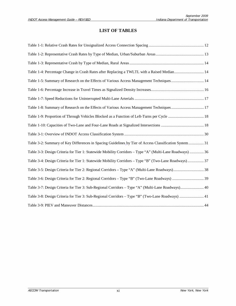
LIST OF TABLES
Table 1-1: Relative Crash Rates for Unsignalized Access Connection Spacing ...................................................... 12
Table 1-2: Representative Crash Rates by Type of Median, Urban/Suburban Areas ............................................... 13
Table 1-3: Representative Crash by Type of Median, Rural Areas ......................................................................... 14
Table 1-4: Percentage Change in Crash Rates after Replacing a TWLTL with a Raised Median ............................. 14
Table 1-5: Summary of Research on the Effects of Various Access Management Techniques ................................ 14
Table 1-6: Percentage Increase in Travel Times as Signalized Density Increases.................................................... 16
Table 1-7: Speed Reductions for Uninterrupted Multi-Lane Arterials .................................................................... 17
Table 1-8: Summary of Research on the Effects of Various Access Management Techniques ................................ 17
Table 1-9: Proportion of Through Vehicles Blocked as a Function of Left-Turns per Cycle ................................... 18
Table 1-10: Capacities of Two-Lane and Four-Lane Roads at Signalized Intersections .......................................... 18
Table 3-1: Overview of INDOT Access Classification System .............................................................................. 30
Table 3-2: Summary of Key Differences in Spacing Guidelines by Tier of Access Classification System ............... 31
Table 3-3: Design Criteria for Tier 1: Statewide Mobility Corridors – Type “A” (Multi-Lane Roadways) .............. 36
Table 3-4: Design Criteria for Tier 1: Statewide Mobility Corridors – Type “B” (Two-Lane Roadways) ................ 37
Table 3-5: Design Criteria for Tier 2: Regional Corridors – Type “A” (Multi-Lane Roadways) .............................. 38
Table 3-6: Design Criteria for Tier 2: Regional Corridors – Type “B” (Two-Lane Roadways) ............................... 39
Table 3-7: Design Criteria for Tier 3: Sub-Regional Corridors – Type “A” (Multi-Lane Roadways) ....................... 40
Table 3-8: Design Criteria for Tier 3: Sub-Regional Corridors – Type “B” (Two-Lane Roadways) ........................ 41
Table 3-9: PIEV and Maneuver Distances ............................................................................................................. 44

September 2009INDOT Access Management Guide – REVISED Indiana Department of Transportation
AECOM Transportation New York, New York1
1.0 INTRODUCTION
1.1 Common Access-Related Problems
At one time or another, virtually all motorists experience frustrations while driving. Congestion, delays,accidents, and wasted fuel while waiting in traffic are all too often some of the more common experiencesencountered by motorists as they navigate our nation’s roadways. As indicated in Reducing TrafficCongestion and Improving Traffic Safety in Michigan Communities: The Access Management Guidebook,prepared by Planning & Zoning Center, Inc. (Reference 1) the following are some typical complaints andquestions often voiced by motorists in regard to transportation, land use, and property access:
Why do I have to wait through two or three light changes at the intersection? Why does it take 10minutes to travel only 1 mile?
Why must I drive on the highway to travel between two stores located relatively close together onthe same side of the road? Is there a way to connect the two properties more directly? Orconstruct a sidewalk between them so I can just walk?
Why are there so many driveways along this road? All the turning traffic is unsafe forpedestrians and cyclists, and it is confusing for motorists as well.
Why are there so many accidents on this roadway? There are so many vehicles turning into andout of all these driveways that it slows down the through traffic and increases the chances of anaccident.
How come my competitor across the street has more business than I do, but yet fewer driveways?
My customers have difficulty exiting my property and turning onto the highway. There is toomuch conflicting traffic and congestion, both inside and outside my property. Will anotherdriveway help?
How can we improve the appearance of this roadway? All the driveways, signs, and other clutterare ugly.
We spend a lot of money to improve our roads, yet we cannot build our way out of congestion.How can we protect our highway investment?
What can we do at the local government level to alleviate traffic congestion through our town?
How can we plan to prevent these problems before they arise in the future?
The complaints above are very often reflective of poor access management practices along our roadwaysand highways, which result in the following:
High accident rates;Poor traffic flow and congestion;Frequent braking by drivers in the through lanes in response to turning vehicles;Unsightly strip development;Neighborhoods disrupted by cut-through traffic;

September 2009INDOT Access Management Guide – REVISED Indiana Department of Transportation
AECOM Transportation New York, New York2
Pressures to widen existing roadways, build bypasses, or incorporate a parallel local street tocreate a one-way couplet;Bypass routes that are as congested as the routes they were intended to relieve;A decrease in property values; andWasted investment in the transportation system.
The good news is that many of the questions and complaints above can be addressed with a change inhow abutting properties access the adjacent roadways, while others can be addressed by improvements tothe design of the roadway. Some improvements can be made quickly, while others requireimplementation over a period of time. In addition, many existing problems along roadways in developedareas can be avoided altogether along other roadways in developing areas if the Indiana Department ofTransportation (INDOT), metropolitan planning organizations (MPOs), counties, and local governmentswork cooperatively and proactively to apply the access management techniques described in this Guide.The techniques and processes used to fix or prevent these traffic problems are commonly referred to as“Access Management.”
1.2 What is Access Management?
In short, access management is the process of balancing the competing needs of traffic movement andland access. Over the last several decades, numerous transportation studies and research efforts havedemonstrated a fundamental relationship between the level of direct property access permitted along aroadway and the roadway’s corresponding operational and safety performance. The introduction ofvehicle conflict points associated with unrestricted vehicular property access has been shown to result inincreases in delays, crash rates, and vehicle emissions. However, most roadways must provide some levelof vehicular access to abutting properties, in addition to providing a mobility function. The basicprinciples of access management involve achieving a balance between mobility and access by limiting thenumber of conflict points, separating the conflict points, and reducing the impediments to through trafficcaused by turning and queued vehicles.
The Access Management Manual (Reference 2), published in 2003 by the Transportation Research Boardof the National Academy of Sciences, is a comprehensive resource that summarizes the results of accessmanagement research conducted over the last several decades. The Access Management Manual definesaccess management, and its purpose, as follows:
Access management is the systematic control of the location, spacing, design, andoperation of driveways, median openings, interchanges, and street connections to aroadway. It also involves roadway design applications, such as median treatments andauxiliary lanes, and the appropriate spacing of traffic signals. The purpose of accessmanagement is to provide vehicular access to land development in a manner thatpreserves the safety and efficiency of the transportation system.
As indicated above, roadways serve two primary functions: 1) moving vehicles, and 2) providing directaccess to property. The primary objective of access management is to protect the functional integrity ofthe roadway system by ensuring that each roadway maintains its intended balance between the movementand access functions.
Figure 1-1 illustrates the balance between movement and access functions for roadways of variousfunctional classifications. Higher-order roadways—such as freeways, expressways, and arterials—have ahigher degree of access control to preserve their movement function. On the other hand, local streets

September 2009INDOT Access Management Guide – REVISED Indiana Department of Transportation
AECOM Transportation New York, New York3
have less restrictive access control because they are intended primarily to provide access to abuttingproperties.
Figure 1-1: Movement versus Access balance by Functional Classification
CompleteAccessControl
Functional Classification
Freeway
ExpresswayStrategic ArterialPrincipal Arterial
Collector
Local StreetUnresticted
Access Cul-de-sac
No access-relatedtraffic
Nothroughtraffic
Incr
easi
ng M
ovem
ent
Increasing Access
Movement
Access
Contemporary practice applies the concept of access management to all roadways in the transportationsystem, not just limited-access freeways and expressways. In fact, access management is criticallyimportant along arterials, collectors, and other high-level to mid-level roadways that are expected toaccommodate both the safe and efficient movement of through traffic, as well as provide access toadjacent properties. The appropriate degree of access control to apply to a particular roadway variesbased on:
The functional role of the roadway in the overall transportation system;The nature of the abutting land uses;The traffic characteristics of the roadway; andThe roadway’s long-term planning objectives.
Because access management involves trade-offs between these often competing objectives, the level ofaccess control established for a particular roadway is usually decided as a matter of policy by thegoverning agency. Each agency must decide what level of performance and operational efficiency it iswilling to accept in exchange for more frequent and direct property access.
1.3 Access Management Objectives
In order to accommodate access to existing and future development in a safe and efficient manner,INDOT seeks to manage the location, design, and type of property access in order to:

September 2009INDOT Access Management Guide – REVISED Indiana Department of Transportation
AECOM Transportation New York, New York4
Reduce traffic congestion;Preserve the flow of traffic;Improve traffic safety and reduce the frequency of crashes;Preserve existing road capacity;Support economic growth;Improve access to businesses and homes;Maintain or improve property values; andPreserve the public investment in the transportation infrastructure.
These objectives can be achieved through the application of the following access management techniquesdescribed in this Guide:
Consolidate and limit (where necessary) access along the State highway system;Promote a supporting local street system;Promote the sharing of site-access to the State highway system; andPromote efficient on-site circulation.
The primary goal is to create an interconnected system of State highways that function safely andefficiently for their useful life. Proper application of access management techniques also assuresbusinesses and drivers of safe and convenient access, and taxpayers of more cost-effective use of theirmoney spent on roads. In addition, access management practices quite often result in more attractivecorridors.
1.4 Basic Access Management Principles
The objectives described above are accomplished by applying the following access managementprinciples:
1. Provide a Specialized Roadway System
As described in the previous section, different types of roadways serve different functions relative toaccess and mobility. It is important to design and manage roadways according to the primary functionsthat they are expected to serve. Roadway operations can be improved by achieving the proper balancebetween traffic flow and access to abutting property.
2. Limit Direct Access to State Highways and Other Major Roadways
State highways and other roadways that serve higher volumes of regional through traffic need a greaterlevel of access control to preserve their traffic movement function. On the other hand, frequent and directproperty access is more compatible with the function of local and collector roadways. “Reasonableaccess” to property abutting a state highway or county road is protected by Indiana State law. However,direct access is not required if other access options are available.
3. Promote Intersection Hierarchy
An efficient transportation network provides appropriate transitions from one classification of roadway toanother. For example, freeways connect to arterials through an interchange that is designed appropriatelyfor the transition. This concept is also extended to surface streets, resulting in a series of intersectiontypes that range from the junction of two major arterial roadways to a residential driveway connecting to
September 2009INDOT Access Management Guide – REVISED Indiana Department of Transportation
AECOM Transportation New York, New York5
a local street. The more important the roadway (i.e. the higher its functional classification) the higher thedegree of access management that should be applied so that the roadway continues to perform accordingto the function it was designed to serve.
4. Locate Signals to Favor Through Movements
Long, uniform spacing of intersections and signals on major roadways enhances the ability to coordinatesignals and ensure continuous movement of traffic at the desired speed. Failure to carefully locate accessconnections or median openings that may later become signalized can cause substantial increases inarterial travel times. In addition, poor signal placement may lead to delays that cannot be overcome bycomputerized signal-timing systems.
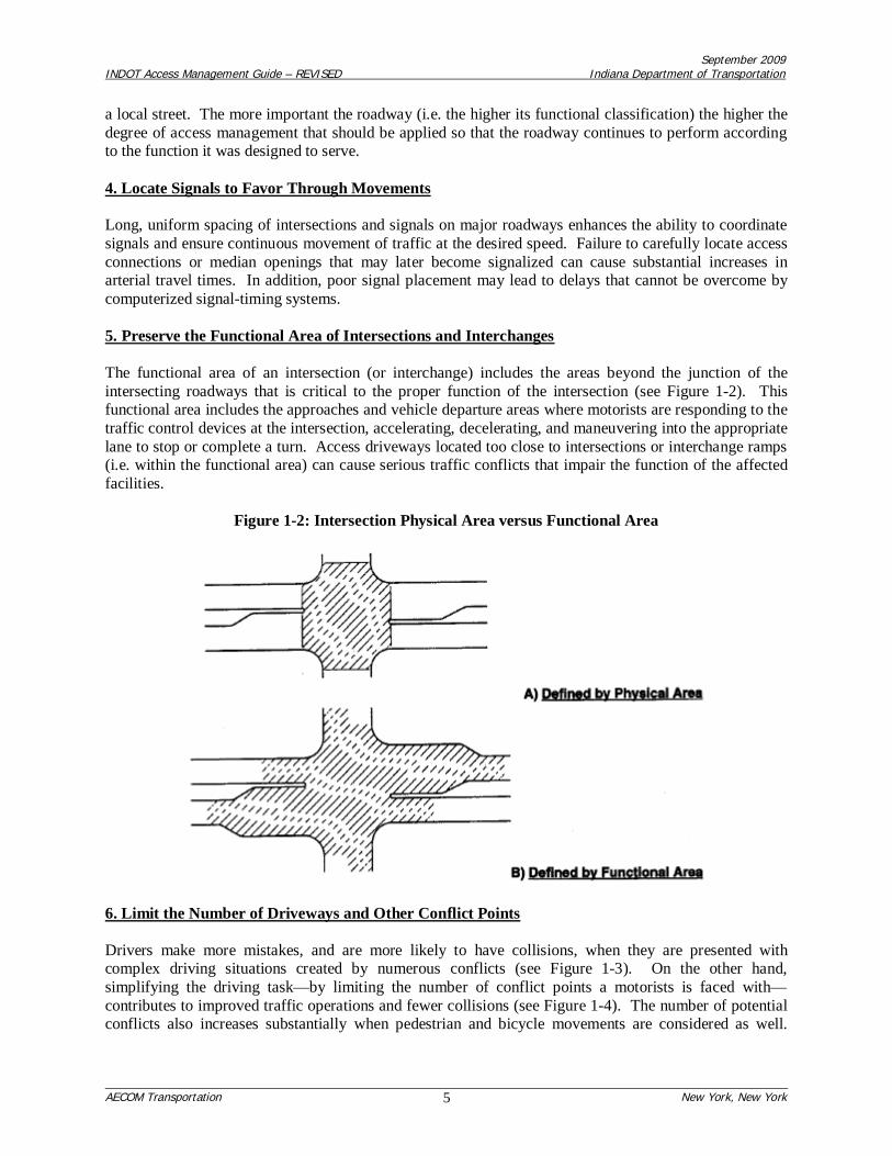
5. Preserve the Functional Area of Intersections and Interchanges
The functional area of an intersection (or interchange) includes the areas beyond the junction of theintersecting roadways that is critical to the proper function of the intersection (see Figure 1-2). Thisfunctional area includes the approaches and vehicle departure areas where motorists are responding to thetraffic control devices at the intersection, accelerating, decelerating, and maneuvering into the appropriatelane to stop or complete a turn. Access driveways located too close to intersections or interchange ramps(i.e. within the functional area) can cause serious traffic conflicts that impair the function of the affectedfacilities.
Figure 1-2: Intersection Physical Area versus Functional Area
6. Limit the Number of Driveways and Other Conflict Points
Drivers make more mistakes, and are more likely to have collisions, when they are presented withcomplex driving situations created by numerous conflicts (see Figure 1-3). On the other hand,simplifying the driving task—by limiting the number of conflict points a motorists is faced with—contributes to improved traffic operations and fewer collisions (see Figure 1-4). The number of potentialconflicts also increases substantially when pedestrian and bicycle movements are considered as well.

September 2009INDOT Access Management Guide – REVISED Indiana Department of Transportation
AECOM Transportation New York, New York6
Therefore, a less complex driving environment is accomplished by also limiting the number and type ofconflicts between vehicles, vehicles and pedestrians, and vehicles and bicyclists.
Figure 1-3: Conflicts at Four-Leg Full-Movement Intersection
Figure 1-4: Reduced Conflict Points at Median-Controlled Intersection

September 2009INDOT Access Management Guide – REVISED Indiana Department of Transportation
AECOM Transportation New York, New York7
7. Separate Driveways and Other Conflict Points
Drivers need sufficient time to address one potential set of conflicts before facing another. The necessaryspacing between conflict areas increases as travel speed increases, in order to provide drivers adequateperception and reaction time. Separating conflict areas helps to simplify the driving task and contributesto improved traffic operations and safety.
8. Remove Turning Vehicles from Through Traffic Lanes
Turning lanes allow drivers to decelerate gradually out of the through lane and wait in a protected area foran opportunity to complete a turn, thereby reducing the severity and duration of conflict between turningvehicles and through traffic. Similarly, acceleration and deceleration lanes allow drivers to transitiontheir travel speeds gradually to enter or leave the through traffic stream. The physical separation ofturning and through traffic improves the safety and efficiency of roadways and intersections.A9. Use Non-Traversable Medians to Manage Left-Turn Movements
Medians channel turning movements on major roadways to designated locations. Non-traversablemedians and other techniques that minimize left-turns or reduce the driver workload can be especiallyeffective in improving roadway safety. Full median openings—that allow left-turns from eitherdirection—are more appropriately reserved for signalized intersections and unsignalized junctions ofarterial and collector streets. Full median openings at other unsignalized locations can adversely affectsafety and traffic flow, but may be appropriate in some areas where analysis indicates that trafficoperations and safety would be improved.
10. Provide a Supporting Local Street System and On-Site Circulation Systems
Interconnections between adjacent developments—as well as connections to the existing local streetsystem—are important in maintaining safe and efficient traffic flow. Well-planned communities providea supporting network of local and collector streets to accommodate development, as well as unifiedproperty access and circulation systems. Interconnected local street systems and on-site circulationsystems provide alternative routes for bicyclists, pedestrians, and drivers alike.
Alternatively, commercial strip development with separate driveways for each business forces even shorttrips to occur on the major roadway, thereby impeding safety and mobility along that roadway.Connectivity can be maintained, while advancing access management objectives, for arterial roadways byensuring that local street connections to the arterial conform with the adopted connection spacing interval.
11. Match Driveway Design with Operational and Safety Needs
Driveways accommodate a wide range of vehicle types, traffic volumes, and vehicle turning speeds. Forexample, a short curb-return radius cannot efficiently accommodate large trucks or the high-speed trafficexpected on a rural arterial, but may be an acceptable design treatment for lower-speed urban areas whereonly passenger cars and single-unit trucks may be expected. Consequently, driveway design should betailored to meet the needs of the vehicles using the driveway.
12. Coordinate Actively with Other Agencies regarding Transportation and Land Use
Effective access management is rarely accomplished by one agency independently. To optimize thebenefits of access management, coordination and cooperation with all the appropriate transportationagencies is essential when introducing design techniques along a roadway or preparing an Access

September 2009INDOT Access Management Guide – REVISED Indiana Department of Transportation
AECOM Transportation New York, New York8
Management Plan. In addition, multi-jurisdictional coordination is essential when applying accessmanagement standards relative to lot split, subdivision, site plan, zoning, and other local land useapplication reviews.
13. Consider Preparing an Access Management Plan or Corridor Management Plan
An Access Management Plan (sometimes referred to as a “Corridor Management Plan”) is acomprehensive study of existing and planned transportation infrastructure and land use within a definedstudy area that establishes a plan for providing reasonable access to all properties, while restoring orpreserving the integrity of the transportation system, through careful consideration of the other principlesdescribed above. The primary benefit of having such a plan is that it lays the foundation for correctingexisting access management problems and preventing others from occurring in the future. An AccessManagement Plan may be formally adopted into a local comprehensive plan.
14. Educate and Involve Others
The effective application of access management is greatly enhanced by on-going education activities toinform planners, engineers, highway designers, and law-makers at the State, county, MPO, and locallevels about the benefits of access management, the principles and techniques for successful application,and current implementation activities.
1.4 Benefits of Access Management
This section outlines the benefits of improving access management policy and practices in Indiana. Thewide-ranging benefits of access management extend to a host of users and affected parties including:
Motorists – who face fewer conflicts and decision points, simplifying the driving task andimproving safety;
Cyclists and Pedestrians – who face fewer conflicts with traffic, and are afforded safe refugelocations such as medians;
Transit riders – who experience reduced delays and travel times, and benefit from an improvedwalking environment;
Business persons – who are served by a more efficient transportation system that captures abroader market area, and benefit from stable property values and a predictable and consistentdevelopment environment;
Freight delivery carriers – who experience reduced delays and improved safety, resulting inshorter transportation times and lower delivery costs;
Government agencies – who benefit from the lower cost of delivering a safe and efficienttransportation system; and
Communities – who benefit from a safer and more attractive transportation system and fromreduced disruptions associated with road widening and construction.
Considerable research and experience from other states has demonstrated the traffic safety andoperational benefits to the motoring public. However, access management extends beyond these to

September 2009INDOT Access Management Guide – REVISED Indiana Department of Transportation
AECOM Transportation New York, New York9
include economic, environmental, system preservation, and aesthetic benefits. This section draws uponnational research and associated literature presented in the Access Management Manual (Reference 2) andNCHRP Report 420: Impacts of Access Management Techniques (Reference 3) to describe these benefitsas they relate to the various access management techniques that are recommended for Indiana. Theaccess management benefits described in this section focus on the following major areas:
System preservation benefitsEconomic benefitsEnvironmental benefitsRoadway safety benefitsTraffic operations benefitsAesthetic benefits
1.4.1 System Preservation Benefits
Access management is asset management. Roads are an important public resource, and are costly tobuild, improve, and replace. Because access management preserves the functional integrity of theroadway system, it is an essential tool for maximizing the return on this investment in publicinfrastructure. Roadways with closely-spaced driveways, irregularly-spaced traffic signals, numerousmedian openings, and inefficient traffic signal progression, suffer the deteriorating effects of increasedtraffic congestion, and degraded safety performance. However, by managing access, Indiana can extendthe life of its highways by providing for more safe and efficient traffic operations, largely within existingrights-of-way.
1.4.2 Economic Benefits
Access management does not only improve the transportation function of the roadway, but it also helpspreserve long-term property values and the viability of abutting development. Poor access managementresults in greater average travel delays and increased travel times. Market area analysis demonstrates thatgreater delays and the associated increases in travel times lead to a corresponding decrease in the marketareas that can be served by businesses. Although the sizes of market areas for each business are different,the proportionate decrease in the size of the market area remains the same. This relationship is illustratedin Figure 1-5.

September 2009INDOT Access Management Guide – REVISED Indiana Department of Transportation
AECOM Transportation New York, New York10
Figure 1-5: Effects of Travel Time on Market Area
Source: Figure 2-4, Access Management Manual, 2003.
1.4.3 Environmental Benefits
Maximum fuel efficiency occurs at constant speeds between 35 and 50 mph. Similarly, minimumemissions for carbon monoxide and organic compounds occur at speeds between 35 and 55 mph. Accessmanagement helps to save fuel and reduce vehicle emissions by helping to ensure the efficientprogression of through vehicles along major roadways, maintaining desired progression speeds, andreducing the propensity for start-and-stop traffic operations due to vehicle turning conflicts. In addition,as described above, access management protects the capacity and efficiency of existing roadways,reducing the need for the construction of new major roadways and bypass roadways, and the associatedenvironmental impacts of these actions.
1.4.4 Roadway Safety Benefits
This section summarizes the roadway safety benefits associated with the following major accessmanagement techniques:
Traffic Signal Spacing;Unsignalized Access Spacing;Median Installations; andLeft-Turn Lanes.
Traffic Signal Spacing
Several studies have found that the number of crashes, and crash rates (i.e. crashes per million vehiclemiles), increase as traffic signal density increases. The effect of signal density on crash rates is illustratedin Figure 1-6.

September 2009INDOT Access Management Guide – REVISED Indiana Department of Transportation
AECOM Transportation New York, New York11
Figure 1-6: Effect of Signal Density and Unsignalized Access Density onAverage Crash Rates in Urban and Suburban Areas
Source: Figure 26, NCHRP Report 420: Impacts of Access Management Techniques, 1999.Also shown in Figure 9-3 in Access Management Manual, 2003 and Exhibit 2-37 in AASHTO Green Book, 2004.
For example, at a density of 20 unsignalized access points per mile, an increase in signal density from2.0 signals per mile to 2.1 to 4.0 signals per mile can result in an estimated 70 percent increase in crash
rate (from approximately 2.8 to 4.8 crashes per million vehicle miles). The average crash rate more thandoubles—from 3.6 crashes to 7.6 crashes per million vehicle miles—at 60 unsignalized access points permile.
Unsignalized Access Spacing
Unsignalized access points introduce conflicts and friction into the traffic stream as vehicles enter andleave the highway. As stated in the 2004 AASHTO “Green Book” (A Policy on Geometric Design ofHighways and Streets, Reference 4):
Driveways are, in effect, intersections… The number of crashes is disproportionatelyhigher at driveways than at other intersections; thus, their design and location meritspecial consideration.
The separation of conflict areas is commonly recognized as an effective way to improve safety formotorists, pedestrians, and bicyclists. Drivers need sufficient time to address one set of potential conflictsbefore facing another. Sufficient spacing between unsignalized access points also permits the design ofauxiliary lanes that reduce the interference on through traffic caused by turning vehicles. Studies haveshown that crash rates rise with increasing frequency of driveways and intersections. Each additionaldriveway increases the number of conflict points, as well as the crash potential. The crash rate indicesshown in Table 1-1 were derived using 10 access points per mile as a base.
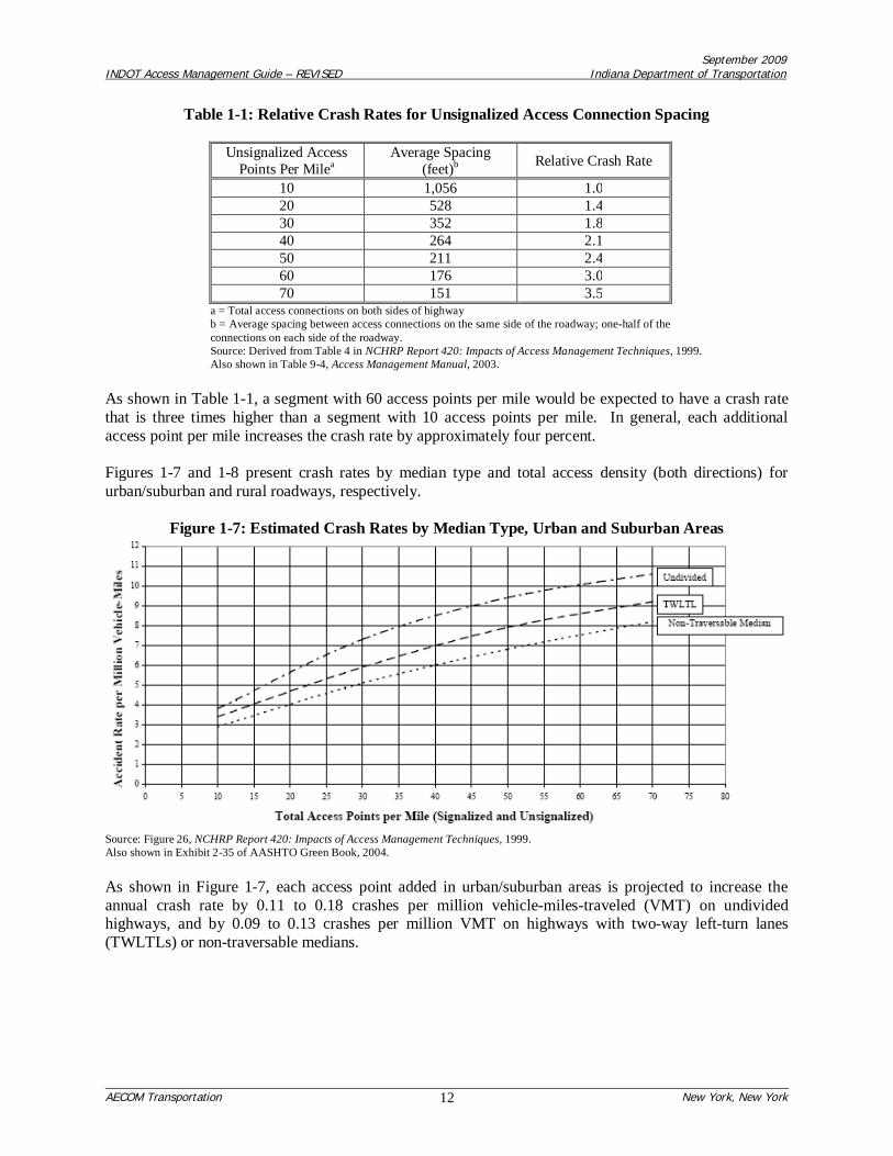
September 2009INDOT Access Management Guide – REVISED Indiana Department of Transportation
AECOM Transportation New York, New York12
Table 1-1: Relative Crash Rates for Unsignalized Access Connection Spacing
Unsignalized AccessPoints Per Milea
Average Spacing(feet)b Relative Crash Rate
10 1,056 1.020 528 1.430 352 1.840 264 2.150 211 2.460 176 3.070 151 3.5
a = Total access connections on both sides of highwayb = Average spacing between access connections on the same side of the roadway; one-half of theconnections on each side of the roadway.Source: Derived from Table 4 in NCHRP Report 420: Impacts of Access Management Techniques, 1999.Also shown in Table 9-4, Access Management Manual, 2003.
As shown in Table 1-1, a segment with 60 access points per mile would be expected to have a crash ratethat is three times higher than a segment with 10 access points per mile. In general, each additionalaccess point per mile increases the crash rate by approximately four percent.
Figures 1-7 and 1-8 present crash rates by median type and total access density (both directions) forurban/suburban and rural roadways, respectively.
Figure 1-7: Estimated Crash Rates by Median Type, Urban and Suburban Areas
Source: Figure 26, NCHRP Report 420: Impacts of Access Management Techniques, 1999.Also shown in Exhibit 2-35 of AASHTO Green Book, 2004.
As shown in Figure 1-7, each access point added in urban/suburban areas is projected to increase theannual crash rate by 0.11 to 0.18 crashes per million vehicle-miles-traveled (VMT) on undividedhighways, and by 0.09 to 0.13 crashes per million VMT on highways with two-way left-turn lanes(TWLTLs) or non-traversable medians.

September 2009INDOT Access Management Guide – REVISED Indiana Department of Transportation
AECOM Transportation New York, New York13
Figure 1-8: Estimated Crash Rates by Median Type, Rural Areas
Source: Figure 25, NCHRP Report 420: Impacts of Access Management Techniques, 1999.Also shown in Exhibit 2-36 of AASHTO Green Book, 2004.
As shown in Figure 1-8, each access point (or driveway) added in rural areas is projected to increase theannual crash rate by 0.07 crashes per million VMT on undivided highways, and 0.02 crashes per millionVMT on highways with TWLTLs or non-traversable medians.
Median Installations
A synthesis of research on the safety effects of alternative median treatments concluded that roadwayswith non-traversable medians are safer than both undivided roadways and those with continuous two-wayleft-turn lanes (TWLTL). Tables 1-2 and 1-3 compare crash rates of various access densities by mediantype for urban/suburban areas, and rural areas, respectively.
Table 1-2: Representative Crash Rates by Type of Median, Urban/Suburban Areas(crashes per million vehicle-miles traveled)
Total Access PointsPer Milea
Median TypeUndivided TWLTL Non-traversable Median
20 3.8 3.4 2.920.01 – 40 7.3 5.9 5.140.01 – 60 9.4 7.9 6.8
> 60 10.6 9.2 8.2All 9.0 6.9 5.6
a = Includes both signalized and unsignalized access points.Source: Table 6 in NCHRP Report 420: Impacts of Access Management Techniques, 1999.

September 2009INDOT Access Management Guide – REVISED Indiana Department of Transportation
AECOM Transportation New York, New York14
Also shown in Table 2-2, Access Management Manual, 2003.
Table 1-3: Representative Crash by Type of Median, Rural Areas(crashes per million vehicle-miles traveled)
Total Access PointsPer Milea
Median TypeUndivided TWLTL Non-traversable Median
15 2.5 1.0 0.915.01 – 30 3.6 1.3 1.2
> 30 4.6 1.7 1.5All 3.0 1.4 1.2
a = Includes both signalized and unsignalized access points.Source: Table 7 in NCHRP Report 420: Impacts of Access Management Techniques, 1999.Also shown in Table 2-2, Access Management Manual, 2003.
Table 1-2 indicates that in urban and suburban areas, undivided highways were found overall toexperience 9.0 crashes per million vehicle miles, as compared with rates of 6.9 for TWLTLs and 5.6 fornontraversable medians. As Table 1-3 shows, in rural areas, undivided highways were found overall toexperience 3.0 crashes per million vehicle miles, as compared with rates of 1.4 for TWLTLs and 1.2 fornon-traversable medians.
Table 1-4 illustrates the findings of a before-and-after study of crash rates along Memorial Drive inAtlanta, Georgia. A raised median was installed along this roadway, which previously was striped for acontinuous TWLTL.
Table 1-4: Percentage Change in Crash Rates after Replacing a TWLTL with a Raised Median
Location Total Crash Rate Injury RateMid-block -55 -59
Intersections -24 -40TOTAL -37 -48
Source: Table 2-4, Access Management Manual, 2003.
As shown in Table 1-4, conversion from a TWLTL configuration to a raised median configurationreduced the total crash rate for the roadway by 37 percent and reduced the injury rate by 48 percent.
Table 1-5 provides a summary of the results of research efforts on the operational and safety effects ofvarious median treatments.
Table 1-5: Summary of Research on the Effects of Various Access Management Techniques
Treatment Effect1. Add continuous TWLTL 35% reduction in total crashes2. Add non-traversable median 35% reduction in total crashes
3. Replace TWLTL with a non-traversable median 15%-57% reduction in crashes on 4-lane roads25%-50% reduction in crashes on 6-lane roads
TWLTL = Two-Way Left-Turn LaneSource: Excerpt from Table 2-5, Access Management Manual, 2003.
Selecting a median alternative—whether retaining an undivided cross-section, installing a two-way left-turn lane, or providing a non-traversable median barrier—is a major decision that will influence the
September 2009INDOT Access Management Guide – REVISED Indiana Department of Transportation
AECOM Transportation New York, New York15
operational and safety characteristics of a roadway. Roadway agencies in Indiana must consider thefollowing in deciding the best median type, or if medians are the preferred method of access management:
Roadway function;Adjacent land use;Supporting street system;Existing access spacing, design, and traffic control features;Traffic speeds;Crash history and future crash potential; andCosts.
Left-Turn Lanes
A synthesis of safety experience indicates that the removal of left-turns from through traffic lanes via anexclusive left-turn bay reduced crash rates between 25 and 50 percent on four-lane roadways.
1.4.5 Traffic Operations Benefits
This section summarizes the traffic operations benefits associated with the following major accessmanagement techniques:
Traffic Signal Spacing;Unsignalized Access Spacing;Median Installations; andLeft-Turn Lanes.
Traffic Signal Spacing
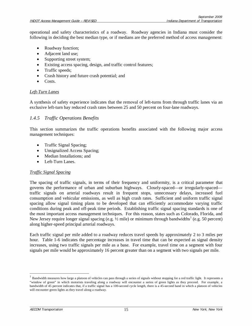
The spacing of traffic signals, in terms of their frequency and uniformity, is a critical parameter thatgoverns the performance of urban and suburban highways. Closely-spaced—or irregularly-spaced—traffic signals on arterial roadways result in frequent stops, unnecessary delays, increased fuelconsumption and vehicular emissions, as well as high crash rates. Sufficient and uniform traffic signalspacing allow signal timing plans to be developed that can efficiently accommodate varying trafficconditions during peak and off-peak time periods. Establishing traffic signal spacing standards is one ofthe most important access management techniques. For this reason, states such as Colorado, Florida, andNew Jersey require longer signal spacing (e.g. ½ mile) or minimum through bandwidths1 (e.g. 50 percent)along higher-speed principal arterial roadways.
Each traffic signal per mile added to a roadway reduces travel speeds by approximately 2 to 3 miles perhour. Table 1-6 indicates the percentage increases in travel time that can be expected as signal densityincreases, using two traffic signals per mile as a base. For example, travel time on a segment with foursignals per mile would be approximately 16 percent greater than on a segment with two signals per mile.
1 Bandwidth measures how large a platoon of vehicles can pass through a series of signals without stopping for a red traffic light. It represents a“window of green” in which motorists traveling along a roadway will encounter a series of green lights as they proceed. For example, abandwidth of 45 percent indicates that, if a traffic signal has a 100-second cycle length, there is a 45-second band in which a platoon of vehicleswill encounter green lights as they travel along a roadway.

September 2009INDOT Access Management Guide – REVISED Indiana Department of Transportation
AECOM Transportation New York, New York16
Table 1-6: Percentage Increase in Travel Times as Signalized Density Increases
Signals Per Mile Percent Increase in Travel Time(compared to 2 signals per mile)
2 03 94 165 236 297 348 39
Source: Derived from Table 3 in NCHRP Report 420: Impacts of Access Management Techniques, 1999.Also shown in Table 2-7 in Access Management Manual, 2003
The Colorado Access Demonstration Project concluded that ½-mile signal spacing could reduce vehicle-hours of delay by more than 60 percent, and vehicle-hours of travel by more than 50 percent, comparedwith signals spaced at ¼-mile intervals with full median openings between signals.
Traffic signals account for most of the delay that motorists experience on arterials and also maycontribute to certain types of crashes. The planning, design, and operation of traffic signals in Indiananeed to achieve a balance among capacity, property access, and progression requirements. Restrictingsignals to those locations where effective progression can be achieved will result in both safety andoperational benefits to the users of the Indiana roadway system.
Unsignalized Access Spacing
Travel times along unsignalized multi-lane divided highways can be estimated using procedures set forthin the Highway Capacity Manual (HCM, Reference 5). Speeds are estimated to be reduced by 0.25 mphfor every access point up to a 10 mph reduction for 40 access points per mile. The HCM procedure iskeyed to access points on one side of a highway, but access points on the opposite side of a highway maybe included where they have a significant effect on traffic flow.
More detailed analysis used for the development of the Highway Capacity Manual showed a speedreduction of 0.15 mph per access point and 0.005 mph per right-turning movement per mile of road (seeTable 1-7). Thus, for 40 access points per mile and 400 right-turns per mile, the speed reduction wouldbe 8.0 mph. If the right-turn volume were to increase to 600, the corresponding speed reduction would be9.0 mph. The HCM value in both cases is 10 mph.

September 2009INDOT Access Management Guide – REVISED Indiana Department of Transportation
AECOM Transportation New York, New York17
Table 1-7: Speed Reductions for Uninterrupted Multi-Lane Arterials
AccessPoints
per Mile
SpeedLoss perAccessPoint(mph)
Hourly Right-Turn Volume Per Mile HCM @0.25mphspeed
loss peraccess
100 200 300 400 500 600 900Speed Loss (mph)
0.5b 1.0 1.5 2.0 2.5 3.0 4.5Combined Speed Loss (mph)
1 0.15a 0.65c 1.15 1.65 2.15 2.65 3.15 4.65 1.255 0.75 1.25 1.75 2.25 2.75 3.25 3.75 5.25 1.2510 1.50 2.00 2.50 3.00 3.50 4.00 4.50 6.00 2.5015 2.25 2.75 3.25 3.75 4.25 4.75 5.25 6.75 3.7520 3.00 3.50 4.00 4.50 5.00 5.50 6.00 7.50 5.0030 4.50 5.00 5.50 6.00 6.50 7.00 7.50 9.00 7.5040 6.00 6.50 7.00 7.50 8.00 8.50 9.00 10.50 10.00
Note: Numbers within box represent sum of marginal totals (i.e. c = a + b).Source: Table 42, NCHRP Report 420: Impacts of Access Management Techniques, 1999.
The research clearly indicates that increasing the spacing between access points improves roadway safetyand the quality of traffic flow. Indiana motorists will experience operational and safety benefits byincreasing the spacing distance between access points, which provides for reduced vehicular travel times,fewer vehicular conflicts and reduced crash potential, and opportunities for the installation of turn lanesand auxiliary lanes.
Median Installations
The basic choices for designing the roadway median are whether to install a continuous TWLTL or a non-traversable median on an undivided roadway, or to replace a two-way left-turn lane with a non-traversablemedian. Two-way left-turn lanes provide greater access and maximize operational flexibility. A non-traversable median design involves the provision of either a raised or depressed median that cannot becrossed or discourages crossing. Such treatments improve traffic safety and operations by removing left-turn movements from the through travel lanes. Medians physically separate opposing traffic, limit access,clearly define conflicts, and provide better pedestrian refuge. Median design requires adequate provisionsfor left-turns and “U”-turns to avoid concentrating these movements at signalized intersections.
Table 1-8 provides a summary of the results of research efforts on the operational effects of variousmedian treatments.
Table 1-8: Summary of Research on the Effects of Various Access Management Techniques
Treatment Effect
1. Add continuous TWLTL 30% decrease in delay30% increase in capacity
2. Add non-traversable median 30% decrease in delay30% increase in capacity
TWLTL = Two-Way Left-Turn LaneSource: Excerpt from Table 2-5, Access Management Manual, 2003.
Selecting a median alternative—whether retaining an undivided cross-section, installing a two-way left-turn lane, or providing a non-traversable median barrier—is a major decision that will influence theoperational and safety characteristics of a roadway. Roadway agencies in Indiana must consider thefollowing in deciding the best median type, or if medians are the preferred method of access management:

September 2009INDOT Access Management Guide – REVISED Indiana Department of Transportation
AECOM Transportation New York, New York18
Roadway functionAdjacent land useSupporting street systemExisting access spacing, design, and traffic control featuresTraffic speedsCrash history and future crash potentialCosts
Left-Turn Lanes
The treatment of left-turns is a major access management strategy. Left-turns at driveways and streetintersections may be accommodated, prohibited, diverted, or separated depending upon specificcircumstances. Left-turn movements made from shared lanes can block through vehicles. The proportionof through vehicles blocked on an approach to a signalized intersection is a function of the number of left-turns per signal cycle, as shown in Table 1-9.
Table 1-9: Proportion of Through Vehicles Blocked as a Function of Left-Turns per Cycle
Left-Turns Per Cycle Proportion of Through Vehicles Blocked1 25%2 40%3 60%
Source: Table 14, NCHRP Report 420: Impacts of Access Management Techniques, 1999.
As shown in Table 1-9, even with only a few left-turns each cycle, the capacity of a shared through/left-turn lane may be 40 to 60 percent that of a standard through-only lane under typical urban or suburbanconditions. Thus, providing left-turn lanes along a four-lane arterial has the potential to increase thenumber of effective travel lanes from approximately 1.5 to 2.0 lanes in each direction—a 33 percentincrease in capacity. Table 1-10 provides the following illustrative capacities for two- and four-lane roadsat signalized intersections, based on application of Highway Capacity Manual methodologies.
Table 1-10: Capacities of Two-Lane and Four-Lane Roads at Signalized Intersections
Approach Configuration Approach Capacity (Vehicles per Hour per Approach)Two-Lane Roads Four-Lane Roads
Shared lane only (50 to 150 left-turns per hour) 425-650 900-1,000With exclusive left-turn lane 750-960 1,100-1,460
Source: Table 15, NCHRP Report 420: Impacts of Access Management Techniques, 1999.
As shown in Table 1-10, the addition of a left-turn lane on the approach results in a capacity increase ofapproximately 50 to 75 percent on two-lane roadways, and approximately 20 to 50 percent on four-laneroadways.
Due to the operational and safety implications associated with allowing left-turns to occur from sharedthrough lanes, left-turns should be removed from the travel lanes whenever possible by providing separateleft-turn lanes. Therefore, provisions for left-turns have widespread implications in Indiana, particularlyalong arterials and collector roads, and are essential to improve safety and preserve capacity.

September 2009INDOT Access Management Guide – REVISED Indiana Department of Transportation
AECOM Transportation New York, New York19
1.4.6 Aesthetic Benefits
By minimizing the number of driveways, consolidating driveways, and constructing medians, accessmanagement techniques provide more landscaping opportunities that can result in more visually pleasingcorridors. These aesthetic benefits can, in turn, help attract new businesses.

September 2009INDOT Access Management Guide – REVISED Indiana Department of Transportation
AECOM Transportation New York, New York20
2.0 INDOT DRIVEWAY PERMIT PROGRAM
2.1 Driveway Permit Process
Indiana State law requires the public to obtain permission from the governmental unit having jurisdictionover a street or highway to construct inside of the right-of-way (ROW) line. INDOT has jurisdiction overthe State highway system and has established a driveway permit process to be followed by all applicants.This section summarizes that process.
2.1.1 Legal Authority for Access Permitting
The administrative requirements associated with the driveway access permit application process for allState highways are governed by the promulgated rules of Title 105, Article 7 of the IndianaAdministrative Code (IAC): Permits for Highways (Reference 6).
2.1.2 Permit Application Forms and Related Documentation
Any business or private party wishing to construct an access driveway onto the State highway right-of-way is required to apply for, and obtain, a permit from INDOT prior to beginning any construction. Apermit is also required for any proposed relocation or alteration of an access, approach, or cross-over andis governed by the same regulations and standards as for a new access driveway.
The appropriate INDOT application form, entitled “Driveway Permit” [Form 1945(RS/3-00)], is used forall routine requests by individuals and corporations for residential and commercial driveways along Statehighways. The form can be obtained on-line via the INDOT website(http://www.in.gov/dot/div/permits/forms/1945.pdf) or from the appropriate INDOT district offices. Thepermit application must be accompanied by drawings, plans, and other documentation sufficient todescribe in detail the specific access proposal to INDOT review staff. Drainage and sub-grade design isalso an integral part of the driveway design and, therefore, must be addressed as part of the drivewaypermit application.
Key items to be provided by the applicant on (or attached to) the driveway permit form include thefollowing:
1) Type of permit (described below);2) Specific driveway location, including INDOT district, sub-district, and reference point number;3) Legal description of the parcel;4) 20-year Certified Title Search or Title Insurance (for commercial driveway permits only);5) Present and proposed use of the parcel(s);6) Bond amount and number (if a bond is required);7) Name, contact information, and signature of applicant; and8) Application fee payable to INDOT.
Types of Driveway Permits
All driveway permits fall into one of the following four (4) types, one of which must be specified on thepermit application form:
September 2009INDOT Access Management Guide – REVISED Indiana Department of Transportation
AECOM Transportation New York, New York21
1) Major Commercial Driveway – Serves a private property used for commercial purposes, or apublic property, that generates enough traffic to require auxiliary lanes. The driveway can belocated in an urban or rural area.
2) Minor Commercial Driveway -- Serves a private property used for commercial purposes, or apublic property, that does not generate enough traffic to require auxiliary lanes. The drivewaycan be located in an urban or rural area.
3) Sub-Minor Commercial Driveway – Serves a private property used for commercial purposes thatdoes not generate more than 25 vehicles per day. The driveway can be located in an urban orrural area.
4) Private Driveway – Serves a private residence, barn, or private garage in improved orunimproved condition in an urban or rural area. The driveway is used by the owner or occupantof the premises, guests, and necessary service vehicles.
Types of Driveways
In addition, all driveways fall into one of the following seven (7) classes, one of which must be specifiedon the permit application form:
Class I – Private residential approach, urban areaClass II – Private residential approach, rural areaClass III – Commercial approach, urban areaClass IV – Commercial approach, rural areaClass V – Field approach (i.e. serving vacant lot, field, or unimproved property), urban and ruralareasClasses VI and VII – Heavy industrial/truck stop approaches, urban and rural areas.
In addition to the driveway permit form, the following supplemental information may be required of theapplicant depending on site-specific circumstances:
1) Additional Disclosure Form – A document used for the purposes of identifying and notifyingother parties (persons, organizations, companies, agencies, etc.) that are, or will be, served by thesubject driveway approach. A separate, notarized disclosure form is required for each party.
2) Permit Bond – Should the applicant/permittee fail to perform properly, this notarized document isused to guarantee that the work performed on the right-of-way by the applicant/permittee will becompleted as required in the conditions and provisions of the permit.
3) Traffic Impact Analysis (TIA) – A technical study, prepared by a registered professional engineer,may be required to evaluate the impact of present and future traffic generated by the proposeddevelopment. The TIA should be prepared in accordance with the Applicant’s Guide to TrafficImpact Studies (Reference 7), an INDOT publication.
4) Agreement to Execute an Access Control Document – In consideration for INDOT granting adriveway permit, the applicant may be required to sign an agreement to execute an access controldocument conveying the access rights for the balance of property frontage owned by theapplicant. This agreement allows INDOT to issue a permit to begin driveway construction beforethe actual deed relinquishing the remaining access rights is prepared and recorded on the

September 2009INDOT Access Management Guide – REVISED Indiana Department of Transportation
AECOM Transportation New York, New York22
property. This document is required for most developments with over 400 feet of frontage alonga State controlled highway.
In addition, INDOT has developed two documents—the “Covenant Limiting Land Uses” (shown inAppendix “C”) and the “Future Traffic Signal Commitment” (shown in Appendix “D”)—that may beused to establish legally-binding agreements with property owners for specific access managementpurposes.
5) Covenant Limiting Land Uses – This document serves as a formal agreement between INDOTand the subject property that, in exchange for an access permit, development density thresholdsfor specific land uses on a subject site cannot be exceeded, unless a Traffic Impact Study isprepared to identify any additional traffic impacts. This agreement is signed by both INDOT andthe property owner and is bound to the deed on the property. The intent of this document is toavoid the potential for additional site traffic generation that would degrade traffic operationsand/or safety on the State highway system and generate the need for improvements (such asauxiliary lanes) that would need to be paid at taxpayer’s expense.
6) Future Traffic Signal Commitment – This document serves as a formal agreement betweenINDOT and the subject property owner that, in exchange for an access permit, obligates theproperty owner to pay for future design and construction of a traffic signal at a specific location(provided traffic signal warrants are met). INDOT agrees to assume the signal maintenance costsfollowing construction. This agreement is signed by both INDOT and the property owner, and isbinding for 10 years from the date of its execution. The intent of this document is to provideINDOT with the opportunity to ensure that a traffic signal would be installed at a location whereit may be needed at some future date (as traffic volumes increase over time), but is not needed atthe present time.
2.1.3 Rules and Guidelines
INDOT encourages applicants to use its Driveway Permit Manual (Reference 8), which explains the Statehighway access permit rules and procedures to be followed when applying for a permit, and also outlinesdesign guidelines associated with locating and constructing the access driveway on the State right-of-way.The guidelines outlined in the Manual are also used by INDOT in reviewing the access permitapplication. The most recent (1996) version of this document can be found on-line via the INDOTwebsite: http://www.in.gov/dot/business/permits/pdf/driveway.pdf
Figure 2-1 shows the table of contents from the INDOT Driveway Permit Manual. The manual contains avariety of design criteria for access driveways on State highways such as:
Number and location of driveways;Driveway separation and clearance distances;Required sight distance;Specific driveway design features (number of lanes, driveway width, return radii, etc.);Drainage and curb design; andChannelization features.
In addition, Section 32 of the Driveway Permit Manual includes general guidelines for when a TrafficImpact Study (TIA) is required of an applicant, based on the size of the proposed land uses. If a TIA isdetermined to be necessary, the Applicant’s Guide to Traffic Impact Studies establishes the methodologyfor, and scope of, the required traffic impact study.

September 2009INDOT Access Management Guide – REVISED Indiana Department of Transportation
AECOM Transportation New York, New York23
It should be noted that the regulations contained in INDOT’s Driveway Permit Manual give considerationto access management principles. The Manual recognizes the need to manage access by specifying theresponsibility of INDOT:
…to regulate and control the location, design, and operation of access driveways and toreconcile, to the extent feasible, the needs and rights of both (land owners and road users).
and that
…driveway design in accordance with these parameters should assure a reasonably good level ofservice to the driveway users and at the same time minimize the interference to highway traffic.
The policies and procedures set forth in the Driveway Permit Manual are supported by the promulgatedrules in the Indiana Administrative Code (Title 105, Article 7: Permits for Highways). However, becausethe Driveway Permit Manual is administered by six district offices, and because is sets forth guidelines(i.e. not standards), its actual application sometimes varies throughout the State, depending on specificcircumstances.

September 2009INDOT Access Management Guide – REVISED Indiana Department of Transportation
AECOM Transportation New York, New York24
Figure 2-1: Table of Contents from Driveway Permit Manual

September 2009INDOT Access Management Guide – REVISED Indiana Department of Transportation
AECOM Transportation New York, New York25
Figure 2-1 (cont’d): Table of Contents from Driveway Permit Manual

September 2009INDOT Access Management Guide – REVISED Indiana Department of Transportation
AECOM Transportation New York, New York26
2.1.4 Processing and Issuance of Permits
Construction of a new driveway or reconstruction of an existing driveway connecting to a State highwayis allowed only after an access permit has been issued by INDOT. INDOT’s review process is dependentupon the type of permit requested and the nature of the permit request. More complicated applicationsusually take longer to review and process, and may involve the Central office in Indianapolis.
As shown in Figure 2-2, INDOT has six (6) district offices throughout the State, each with numerous sub-districts. The sub-district offices are responsible for accepting and reviewing the access permitapplication form and other supporting documentation included in the submittal package prepared by theapplicant. Submittal packages deemed complete by the sub-district office are forwarded to the respectivedistrict office where they are reviewed for compliance with current INDOT guidelines and specifications(including the Roadway Design Manual and the Driveway Permit Manual).
If the permit application and supporting materials are determined to be in accordance with all establishedrequirements and regulations—and the applicant is not seeking access within a limited access right-of-way corridor—an access permit is granted by the district office subject to appropriate conditions andprovisions. However, if the applicant is seeking access within a limited access corridor, the district officeeither: 1) denies the permit, or 2) forwards it to the Central office in Indianapolis with associatedrecommendations. Approvals for any break in the limited access right-of-way can only be granted by theChief Engineer in the Central office. For development projects that are not within a limited access right-of-way corridor, but require an access control document to prohibit out-lot access to the State highwaysystem, the district office coordinates preparation of the appropriate documentation that is then recordedon the subject property.
In practice, INDOT staff typically does not deny applications outright. Rather, staff typically works withthe developer or property owner to help ensure that key site and access design issues are resolved.
2.1.5 Access Permit Enforcement
Permit enforcement, while typically the responsibility of the sub-district and district offices, may alsorequire the involvement of the State Attorney General’s office. All construction work by the applicantwithin State right-of-way must proceed in accordance with the conditions and provisions specified in theissued access permit. INDOT may halt any activity if the permit conditions and provisions are notsatisfied (or if an individual fails to obtain the appropriate permit). In instances where a driveway isconstructed illegally or without a permit, INDOT will request an application be filed and a permit issuedretroactively if the driveway is acceptably designed and located. If not, differences are typically resolvedbefore legal activity commences. In rare instances, when there is no cooperation from the propertyowner, INDOT files for court orders through the Attorney General’s Office. The Attorney General’sOffice determines which cases to take to court and the best means of addressing violations. Any costsincurred by INDOT in correcting a failure to comply with the terms and conditions of a permit, or afailure to obtain a permit, are borne by the property owner.
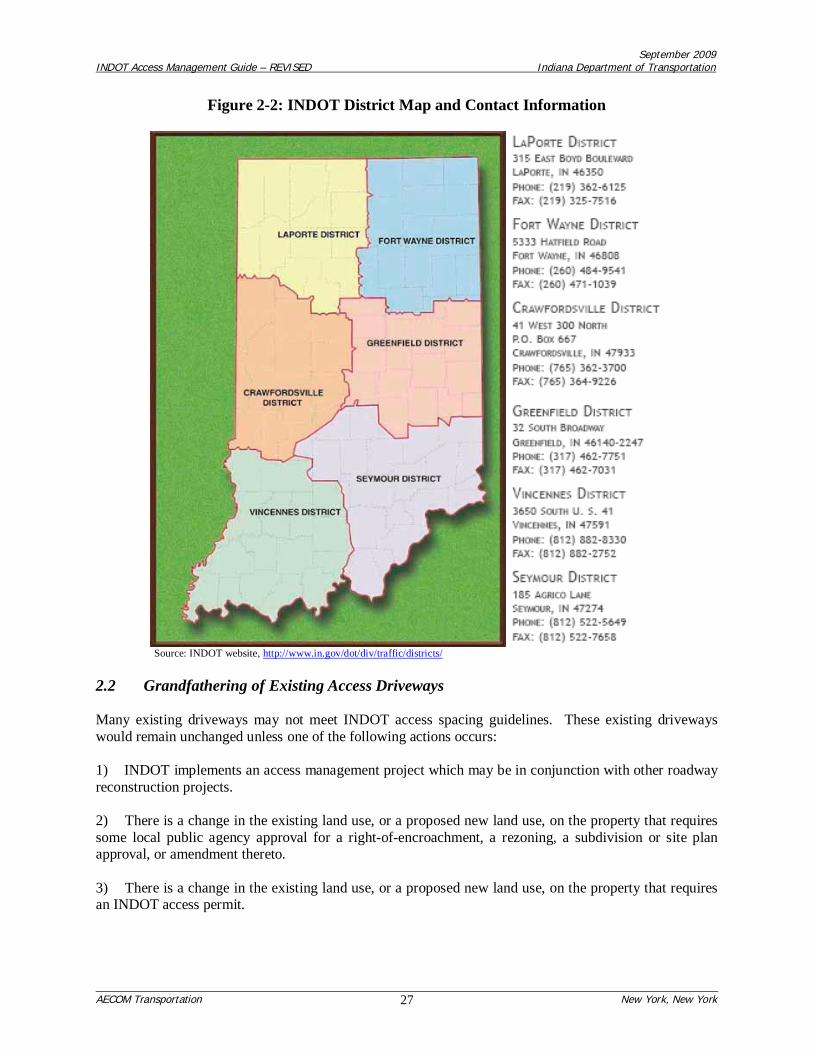
September 2009INDOT Access Management Guide – REVISED Indiana Department of Transportation
AECOM Transportation New York, New York27
Figure 2-2: INDOT District Map and Contact Information
Source: INDOT website, http://www.in.gov/dot/div/traffic/districts/
2.2 Grandfathering of Existing Access Driveways
Many existing driveways may not meet INDOT access spacing guidelines. These existing drivewayswould remain unchanged unless one of the following actions occurs:
1) INDOT implements an access management project which may be in conjunction with other roadwayreconstruction projects.
2) There is a change in the existing land use, or a proposed new land use, on the property that requiressome local public agency approval for a right-of-encroachment, a rezoning, a subdivision or site planapproval, or amendment thereto.
3) There is a change in the existing land use, or a proposed new land use, on the property that requiresan INDOT access permit.

September 2009INDOT Access Management Guide – REVISED Indiana Department of Transportation
AECOM Transportation New York, New York28
3.0 INDOT ACCESS CLASSIFICATION SYSTEM AND DESIGN CRITERIA
As stated previously, INDOT’s access management program seeks to:
Reduce traffic congestion;Preserve the flow of traffic;Improve traffic safety and reduce the frequency of crashes;Preserve existing road capacity;Support economic growth;Improve access to businesses and homes;Maintain or improve property values; andPreserve the public investment in the transportation infrastructure.
These objectives are accomplished by:
Establishing appropriate levels of allowable access for each State highway through theimplementation of a statewide Access Classification System;
Managing the driveway permitting process to ensure that new driveways proposed in conjunctionwith private development are properly located and designed;
Enforcing identified permit violations;
Working cooperatively and proactively with other government agencies, property owners, and thepublic when access and land use decisions affecting State highways must be made;
Incorporating access management techniques into design plans for new State highways andimprovement plans for existing State highways;
Educating INDOT staff and others regarding INDOT’s specific access management-relatedpolicies and procedures.
3.1 Access Classification System
An Access Classification System is typically used to establish the level of allowable access for roadwaysof varying levels of importance in the State highway system. In essence, an Access Classification Systemis a hierarchy of access categories that forms the basis for the application of access management. Eachaccess category sets forth criteria governing the access-related standards and characteristics forcorresponding roadways. These access categories ultimately define where access can be allowed betweenprivate developments and the roadway system, and where it should be denied or discouraged. Theydefine spacing standards for signalized intersections, and where a driveway should be restricted to right-in/right-out operation. Defining access categories involves consideration of the following factors:
1) Roadway Functional Classification System – As alluded to above, the foundation of an accessclassification system is the functional classification system (arterial, collector, etc.) that reflectsthe general purpose of each roadway within the transportation system.
2) Roadway Design Characteristics – In addition, roadway characteristics associated with geometricdesign (such as the number of lanes, shoulder widths, design speed, and particularly mediantreatments) should be considered in defining access categories.

September 2009INDOT Access Management Guide – REVISED Indiana Department of Transportation
AECOM Transportation New York, New York29
3) Degree of Urbanization – Factors (such as intersection frequency, development intensity, trafficvolume, and speed conditions) can be used to help define the degree of urbanization, and could beconsidered in defining access categories.
Typically, direct property access is prohibited from freeways and expressways. Direct property access isalso typically denied (or highly restricted) for higher-level arterial class roadways, although access maybe provided where no reasonable alternative access is available. Direct property access is often permittedfor lower level arterials and collectors, although there may be limitations on the number and location ofaccess points. Direct property access is typically allowed on local roadways and frontage roads, subjectto safety considerations (such as maintaining proper sight distances).
Table 3-1 provides an overview of the INDOT Access Classification System. As shown in Table 3-1, theaccess classification system uses the Planning Level Corridor Hierarchy as the primary basis for a tieredsystem of access categories. Because interstate highways and freeways are of the highest level ofimportance and are fully access-controlled, they represent the highest category within the accessclassification system. However, spacing criteria for these roadways are already established in othersources such as the INDOT Roadway Design Manual and AASHTO’s A Policy on Geometric Design ofHighway and Streets (the “Green Book”).
Tiers 1 and 2 of the Access Classification System include all “Statewide Mobility Corridors” and“Regional Corridors,” respectively, on the INDOT highway system. Tier 3 of the Access ClassificationSystem includes all “Local Access Corridors” on the INDOT highway system. However, because LocalAccess Corridors serve a mobility function and accommodate some through traffic volume, the term“Sub-Regional Corridors” has been used instead for Tier 3 roadways in the Access Classification System.
As shown in Table 3-1, Statewide Mobility Corridors (Tier 1), Regional Corridors (Tier 2), and Sub-Regional Corridors (Tier 3) are each subdivided into two subcategories (Type “A” and Type “B”) thatreflect distinct variations within each of these Tiers. For all three tiers, the Type “A” distinction appliesexclusively to multi-lane roadways, and the Type “B” distinction applies exclusively to two-laneroadways. The purpose for this distinction was to reflect the different characteristics associated with two-lane roadways.

Level of Importance /Access Category Type Traffic Function Design Standards
Interstate Highways andFreeways
Accommodates high-speed, high-volume, and long-distancethrough traffic for interstate, intrastate, or intercity travel. Also canprovide a major connection between suburban areas andmetropolitan centers.
Multi-lane roadways with full access-control. Access via intechanges only (no direct private access to abuttingproperties allowed). All roadways are multi-lane and median-controlled/divided. At-grade intersections andaccess driveways not permitted under any circumstances. Interchange spacing is in accordance with theINDOT Roadway Design Manual .
A
Provides connections to major metropolitan areas within the Stateand to neighboring states. Provides accessibility to cities andregions around the state. Accommodates high-speed and long-distance trips. Can accommodate heavy commercial vehicle traffic.Includes most rural non-Interstate routes on the Principal ArterialSystem.
Includes all multi-lane roadways. Access generally occurs only at interchanges or at-grade public streetintersections. Some movements at public street intersections may need to be restricted based on existing andprojected operating conditions and intersection spacing. Private access to abutting properties is not allowed,unless property has no reasonable alternative access (via joint-use driveways or frontage roads) or opportunityto obtain such access.
B Same traffic function as Tier 1, Type A. Generally provides keyrural connections between metropolitan areas.
Includes only 2-lane roadways. Access generally only occurs via at-grade public street intersections. Somemovements at public street intersections may need to be restricted based on existing and projected operatingconditions and intersection spacing. Private access to abutting properties is not allowed, unless property hasno reasonable alternative access (via joint-use driveways or frontage roads) or opportunity to obtain suchaccess.
A
Provides connections to smaller cities and regions, feeds traffic tothe Statewide Mobility Corridors, and provides for regionalaccessibility. Accommodates moderate to high-speed traffic,medium distance trips, and moderate volumes of through traffic andcommercial vehicle traffic. Can accommodate local heavy trafficvolumes.
Includes all multi-lane roadways. Generally median-controlled/divided. Public street connections occur at-grade. Private access to abutting properties is allowed. Full movements and signalization are allowed forpublic steet connections and "commercial major" driveways only. All other private driveways are limited tounsignalized, right-in/right-out (median-controlled) access, with left-turns allowed conditionally subject to INDOTreview and approval.
B Same traffic function as Tier 2, Type A.
Includes only 2-lane roadways. Public street connections occur at-grade. Private access to abutting propertiesis allowed. Full movements are allowed at all private driveways, with the exception of access drivewayslocated within 300 feet of an existing (or potential future) signalized intersection which must be right-in/right-out(with left-turn access allowed conditionally subject to INDOT review and approval). Signalization is allowed forpublic street intersections and "commercial major" driveways only.
ATypically provides access to local residences and businesses inrural areas and small towns. Accommodates moderate to lowspeed traffic, short distance trips, and moderate local trafficvolumes.
Includes all multi-lane roadways. Public street connections occur at-grade and may be signalized."Commercial major" driveways may also be signalized. Full movements are allowed at public streetintersections and all private access driveways.
B Same traffic function as Tier 3, Type A.Includes ony 2-lane roadways. Public street connections occur at-grade and may be signalized. "Commercialmajor" driveways may also be signalized. Full movements are allowed at public street intersections and allprivate access driveways.
Tier 3: Sub-RegionalCorridors
Tier 1: Statewide MobilityCorridor
Tier 2: Regional Corridors
Table 3-1Overview of INDOT Access Classification System

September 2009INDOT Access Management Guide – REVISED Indiana Department of Transportation
AECOM Transportation New York, New York31
A summary of the key differences in spacing guidelines for the three tiers is shown in Table 3-2:
Table 3-2: Summary of Key Differences in Spacing Guidelinesby Tier of Access Classification System
Tier Ideal Signalized IntersectionSpacing Guideline*
Minimum Acceptable Bandwidth for Deviationfrom Ideal Signalized Intersection Spacing
Urban Rural1A and 1B ½ mile 45% 50%
2A and 2B ½ mile 40% 45%
3A and 3B ½ mile 35% 40%* A ¼-mile spacing guideline applies to all State highways with speeds 40 mph located within a built-up urban area, regardless of tier.
As shown above, the ideal spacing guideline for signalized intersections on all tiers of the State highwaysystem is ½ mile in most cases. The ½ mile spacing typically accommodates progression speeds rangingbetween approximately 30 mph and 60 mph, depending on the length of the signal cycle that is selected.
As noted in the table above, for State highways with posted speeds of 40 mph or less that are located inbuilt-up urban areas, a ¼ mile spacing guideline applies. Currently, these conditions would apply to atotal of approximately 6.8 miles of the INDOT highway system under Tiers 3A and 3B. The ¼ milespacing typically accommodates progression speeds ranging between approximately 15 mph and 30 mph,depending on the length of the signal cycle that is selected.
Where the ideal signal spacing guidelines cannot be met, a deviation may be allowed, provided aminimum acceptable bandwidth criterion can be met. As shown above, this minimum acceptablebandwidth criterion varies depending on the tier of the State highway system, and the location of thehighway in either an urban or rural area.
Bandwidth measures how large a platoon of vehicles can pass through a series of signals without stoppingfor a red traffic light. It represents a “window of green” in which motorists traveling along a roadwaywill encounter a series of green lights as they proceed. For Tier 1 State highways, the minimumbandwidth is defined to be 45-percent in urban areas and 50-percent in rural areas. This means that if atraffic signal has a 100-second cycle length, there is a 45-second band in which a platoon of vehicles willencounter green lights as they travel along a State highway in urban areas, and a 50-second band for ruralareas. In addition to minimum bandwidth, the signal spacing for a particular roadway is also a function ofthe cycle length of the signals and the desired progression speed for that roadway.
The spacing guidelines for unsignalized intersections and driveways are based on speed as specified inTable 8.1 of INDOT’s Driveway Permit Manual, irrespective of tier. The decision-making process withrespect to the application of the access spacing guidelines may also consider existing and projected futuretraffic volumes and the type of environment (built-up, intermediate, suburban, and rural). In general,greater flexibility is needed for lower speed roadways in built-up areas.
Driveways should not be situated within the longitudinal length of an auxiliary lane from an adjacentintersection along any State highway. It should be noted that auxiliary lane criteria are not defined as partof the access classification system described above. The criteria for various types of auxiliary lanes aredefined in the Roadway Design Manual and the Driveway Permit Manual, based on the roadway cross-section, traffic volume, and speed.

September 2009INDOT Access Management Guide – REVISED Indiana Department of Transportation
AECOM Transportation New York, New York32
Tables 3-3 through 3-8 at the end of this section provide the following details for Tiers 1, 2 and 3:
Type of access permitted (at-grade intersection, private driveway)Traffic movements allowed (full movements, right-in/right-out only, etc.)Traffic control devices permitted (traffic signal, STOP sign)Spacing criteria for public intersections and driveways
Detailed descriptions of the design criteria for each access category, corresponding to Tables 3-2 through3-8, are provided in the following sections.
3.2 Design Criteria
3.2.1 Tier 1A – Statewide Mobility Corridors (Multi-Lane)
Tier 1A is comprised of all multi-lane Statewide Mobility Corridors on the INDOT system. At-grade,public street intersections are permitted along these roadways and may be signalized contingent upon theintersection meeting the warrant criteria set forth in the Manual on Uniform Traffic Control Devices(MUTCD) and provided INDOT concurs with the signal installation based on spacing and otherconsiderations. Full turning movements may be allowed for public street intersections, although INDOTmay require some movements be restricted based on intersection spacing requirements, and existing andprojected operating conditions.
Access driveways are restricted under Tier 1A, and may be allowed by INDOT only if the property ownerhas no reasonable alternative access (or opportunity to obtain such access), and joint-use driveways andfrontage roads are infeasible. Full turning movements may be allowed for Commercial Major driveways(i.e. those requiring an auxiliary lane), although INDOT may require some movements be restricted basedon intersection spacing requirements, and existing and projected operating conditions. Commercial Majordriveways may also be signalized contingent upon the intersection meeting the warrant criteria set forth inthe MUTCD and provided INDOT concurs with the signal installation. All other driveways are restrictedto Right-In/Right-Out (RIRO) movements, with left-turn access allowed contingent upon INDOT reviewand approval.
The spacing criteria for all signalized intersections and driveways on Tier 1A State highways are based onan ideal signalized intersection spacing of ½ mile. Where this ideal signal spacing cannot be met, aminimum green bandwidth of 45-percent in urban areas and 50-percent in rural areas is required.
The spacing criteria for all unsignalized intersections and driveways is based on speed as indicated in theDriveway Permit Manual, except for locations where future development may trigger the need for asignal, in which case the signalized spacing distance is to be applied instead.
3.2.2 Tier 1B – Statewide Mobility Corridors (Two-Lane)
Tier 1B is comprised of all two-lane Statewide Mobility Corridors on the INDOT system. At-grade,public street intersections are permitted along these roadways and may be signalized contingent upon theintersection meeting the warrant criteria set forth in the MUTCD and provided INDOT concurs with thesignal installation. Full turning movements are generally allowed for public street intersections.
Access driveways are restricted under Tier 1B, and may be allowed by INDOT only if the property ownerhas no reasonable alternative access (or opportunity to obtain such access), and joint-use driveways andfrontage roads are infeasible. Full turning movements may be allowed for driveways permitted on Tier

September 2009INDOT Access Management Guide – REVISED Indiana Department of Transportation
AECOM Transportation New York, New York33
1B roadways, with the exception of those located within the functional area of an existing (or potentialfuture) signalized intersection, in which case the driveway is restricted to RIRO movements only (left-turn access may be allowed conditionally upon INDOT review and approval). Commercial Majordriveways may be signalized contingent upon the intersection meeting the warrant criteria set forth in theMUTCD and provided INDOT concurs with the signal installation.
The spacing criteria for all signalized intersections and driveways on Tier 1B State highways are based onan ideal signalized intersection spacing of ½ mile. Where this ideal signal spacing cannot be met, aminimum green bandwidth of 45-percent in urban areas and 50-percent in rural areas is required (samecriteria as Tier 1A).
The spacing criteria for all unsignalized intersections and driveways is based on speed as indicated in theDriveway Permit Manual, except for locations where future development may trigger the need for asignal, in which case the signalized spacing distance is to be applied instead.
3.2.3 Tier 2A – Regional Corridors (Multi-Lane)
Tier 2A is comprised of all multi-lane Regional Corridors on the INDOT system. At-grade, public streetintersections are permitted along these roadways and may be signalized contingent upon the intersectionmeeting the warrant criteria set forth in the MUTCD and provided INDOT concurs with the signalinstallation. Full turning movements generally are allowed for public street intersections.
Access driveways are allowed under Tier 2A subject to certain restrictions. Full turning movementsgenerally may be allowed for all Commercial Major driveways, with the exception of those located withinthe functional area of an existing (or potential future) signalized intersection, in which case the drivewayis restricted to RIRO movements only (left-turn access may be allowed conditionally upon INDOT reviewand approval). Commercial Major driveways may be signalized contingent upon the intersection meetingthe warrant criteria set forth in the MUTCD and provided INDOT concurs with the signal installation.All other driveways are restricted to RIRO movements, with left-turn access allowed contingent uponINDOT review and approval.
The spacing criteria for all signalized intersections and driveways on Tier 2A State highways are based onan ideal signalized intersection spacing of ½ mile. Where this ideal signal spacing cannot be met, aminimum green bandwidth of 40-percent in urban areas and 45-percent in rural areas is required.
The spacing criteria for all unsignalized intersections and driveways is based on speed as indicated in theDriveway Permit Manual, except for locations where future development may trigger the need for asignal, in which case the signalized spacing distance is to be applied instead.
3.2.4 Tier 2B – Regional Corridors (Two-Lane)
Tier 2B is comprised of all two-lane Regional Corridors on the INDOT system. At-grade, public streetintersections are permitted along these roadways and may be signalized contingent upon the intersectionmeeting the warrant criteria set forth in the MUTCD and provided INDOT concurs with the signalinstallation. Full turning movements generally are allowed for public street intersections.
Access driveways are allowed under Tier 2B subject to certain restrictions. Full turning movementsgenerally may be allowed for all driveways, with the exception of those located within the functional areaof an existing (or potential future) signalized intersection, in which case the driveway is restricted toRIRO movements only (left-turn access may be allowed conditionally upon INDOT review and

September 2009INDOT Access Management Guide – REVISED Indiana Department of Transportation
AECOM Transportation New York, New York34
approval). Commercial Major driveways may be signalized contingent upon the intersection meeting thewarrant criteria set forth in the MUTCD and provided INDOT concurs with the signal installation.
The spacing criteria for all signalized intersections and driveways on Tier 2B State highways are based onan ideal signalized intersection spacing of ½ mile. Where this ideal signal spacing cannot be met, aminimum green bandwidth of 40-percent in urban areas and 45-percent in rural areas is required (same asTier 2A).
The spacing criteria for all unsignalized intersections and driveways are based on speed as indicated in theDriveway Permit Manual, except for locations where future development may trigger the need for asignal, in which case the signalized spacing distance is to be applied instead.
3.2.5 Tier 3A – Sub-Regional Corridors (Multi-Lane)
Tier 3A is comprised of all multi-lane Local Access Corridors on the INDOT system. At-grade, publicstreet intersections are permitted along these roadways and may be signalized contingent upon theintersection meeting the warrant criteria set forth in the MUTCD and provided INDOT concurs with thesignal installation. Full turning movements generally are allowed for public street intersections.
Access driveways are allowed under Tier 3A subject to certain restrictions. Full turning movements maybe allowed for driveways permitted, with the exception of those located within the functional area of anexisting (or potential future) signalized intersection, in which case the driveway is restricted to RIROmovements only (left-turn access may be allowed conditionally upon INDOT review and approval).Commercial Major driveways may be signalized contingent upon the intersection meeting the warrantcriteria set forth in the MUTCD and provided INDOT concurs with the signal installation.
The spacing criteria for all signalized intersections and driveways on Tier 3A State highways are based onan ideal signalized intersection spacing of ½ mile. Where this ideal signal spacing cannot be met, aminimum green bandwidth of 35-percent in urban areas and 40-percent in rural areas is required.
For Tier 3A State highways with posted speeds of 40 mph or less that are located in built-up urban areas,a ¼ mile spacing guideline applies. Currently, these criteria would apply to a total of approximately 2.9miles of the INDOT highway system under Tier 3A. The ¼ mile spacing typically accommodatesprogression speeds ranging between approximately 15 mph and 30 mph, depending on the length of thesignal cycle that is selected.
The spacing criteria for all unsignalized intersections and driveways is based on speed as indicated in theDriveway Permit Manual, except for locations where future development may trigger the need for asignal, in which case the signalized spacing distance is to be applied instead.
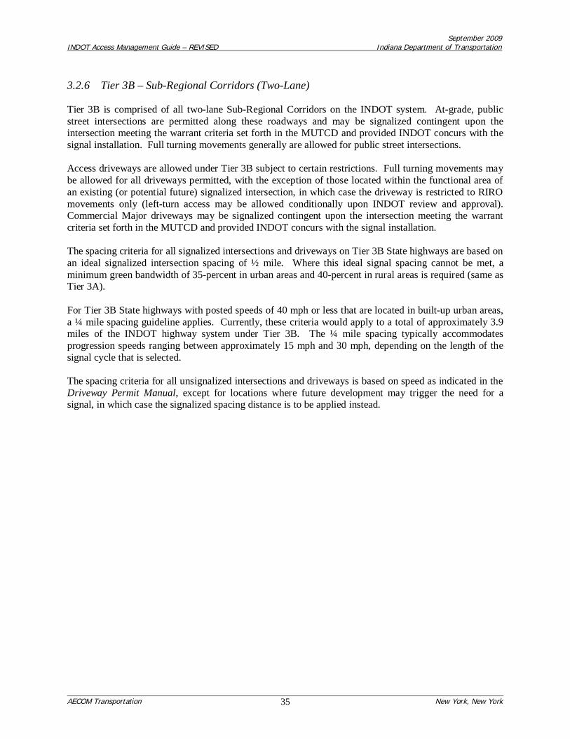
September 2009INDOT Access Management Guide – REVISED Indiana Department of Transportation
AECOM Transportation New York, New York35
3.2.6 Tier 3B – Sub-Regional Corridors (Two-Lane)
Tier 3B is comprised of all two-lane Sub-Regional Corridors on the INDOT system. At-grade, publicstreet intersections are permitted along these roadways and may be signalized contingent upon theintersection meeting the warrant criteria set forth in the MUTCD and provided INDOT concurs with thesignal installation. Full turning movements generally are allowed for public street intersections.
Access driveways are allowed under Tier 3B subject to certain restrictions. Full turning movements maybe allowed for all driveways permitted, with the exception of those located within the functional area ofan existing (or potential future) signalized intersection, in which case the driveway is restricted to RIROmovements only (left-turn access may be allowed conditionally upon INDOT review and approval).Commercial Major driveways may be signalized contingent upon the intersection meeting the warrantcriteria set forth in the MUTCD and provided INDOT concurs with the signal installation.
The spacing criteria for all signalized intersections and driveways on Tier 3B State highways are based onan ideal signalized intersection spacing of ½ mile. Where this ideal signal spacing cannot be met, aminimum green bandwidth of 35-percent in urban areas and 40-percent in rural areas is required (same asTier 3A).
For Tier 3B State highways with posted speeds of 40 mph or less that are located in built-up urban areas,a ¼ mile spacing guideline applies. Currently, these criteria would apply to a total of approximately 3.9miles of the INDOT highway system under Tier 3B. The ¼ mile spacing typically accommodatesprogression speeds ranging between approximately 15 mph and 30 mph, depending on the length of thesignal cycle that is selected.
The spacing criteria for all unsignalized intersections and driveways is based on speed as indicated in theDriveway Permit Manual, except for locations where future development may trigger the need for asignal, in which case the signalized spacing distance is to be applied instead.

Commercial Major All other driveways
Yes Restricted Restricted
Full movements3 Full movements3 RIRO4
Traffic signal5 Traffic signal5 STOP6
Unsignalized spacing per Driveway PermitManual 7
Unsignalized spacing per Driveway PermitManual
Ideal signalized spacing = 1/2 mile8,9 Ideal signalized spacing = 1/2 mile8,9
Unsignalized spacing per Driveway PermitManual 7
Unsignalized spacing per Driveway PermitManual
Ideal signalized spacing = 1/2 mile10 Ideal signalized spacing = 1/2 mile10
Notes:
Table 3-3Design Criteria for Tier 1: Statewide Mobility Corridors - Type "A" (Multi-Lane Roadways)
Spacing criteria
At-Grade Public Street IntersectionsAccess Driveways1,2
Permitted?
Traffic movements allowed
Traffic control devices
Spacing per Driveway Permit Manual
9: Where signalized intersection spacing guideline can not be met, minimum bandwidth must equal 45%. Bandwidth will apply to progression in both directions along a two-way state highway for length of the signal system segment defined by INDOT. Where the existing signal bandwidth on the State highway is less than or equal to theminimum bandwidth guidelines stated in the ACS, no further deterioration in the existing bandwidth will be allowed without a waiver.
3: Some movements may need to be restricted based on intersection spacing, and existing and projected operating conditions. Limited to Right-In/Right-Out (RIRO)movements for driveways within the functional area of an existing (or potential future) signalized intersection. A median may be required to reinforce RIRO movements. Left-turn access may be allowed conditionally subject to INDOT review and approval.
5: Traffic signal installation subject to traffic signal warrant criteria per MUTCD and additional assessment by INDOT, including signal criteria. Where a signal is to beinstalled, the new approach should be situated opposite an existing 3-leg intersection, if present.
7: Except where future development may trigger the need for a signal, in which case the signalized spacing distance is to be applied.6: STOP control applies to the access driveway and not to the State highway.
10: Where signalized intersection spacing guideline can not be met, minimum bandwidth must equal 50%. Bandwidth will apply to progression in both directions along a two-way state highway for length of the signal system segment defined by INDOT. Where the existing signal bandwidth on the State highway is less than or equal to the minimumbandwidth guidelines stated in the ACS, no further deterioration in the existing bandwidth will be allowed without a waiver.
8: Signal spacing = 1/4 mile for roadways 40 mph in built-up urban areas.
4: RIRO driveways are allowed if property owner has no reasonable alternative access (or opportunity to obtain such access) and joint-use driveways and frontage roads areinfeasible. Left-turn access may be allowed conditionally subject to INDOT review and approval. A median may be required to reinforce RIRO movements in high-accidentlocations. At INDOT's discretion, driveways may be restricted to RIRO movements through installation of a section of median where a two-way left-turn lane currently exists.
Urban areas
Rural areas
1: Driveways should be avoided within the functional area of an existing (or potential future) signalized intersection.2: Driveways are allowed if property owner has no reasonable alternative access (or opportunity to obtain such access) and joint-use driveways and frontage roads areinfeasible.
Spacing per Driveway Permit Manual

Commercial Major All other driveways
Yes Restricted Restricted
Full movements Full movements3 Full movements3
Traffic signal4 Traffic signal4 STOP5
Unsignalized spacing per Driveway PermitManual 7
Unsignalized spacing per Driveway PermitManual
Ideal signalized spacing = 1/2 mile7,8 Ideal signalized spacing = 1/2 mile7,8
Unsignalized spacing per Driveway PermitManual 7
Unsignalized spacing per Driveway PermitManual
Ideal signalized spacing = 1/2 mile9 Ideal signalized spacing = 1/2 mile9
Notes:
Table 3-4Design Criteria for Tier 1: Statewide Mobility Corridors - Type "B" (Two-Lane Roadways)
At-Grade Public Street IntersectionsAccess Driveways1,2
Permitted?
Traffic movements allowed
Spacing criteria
7: Signal spacing = 1/4 mile for roadways 40 mph in built-up urban areas.
3: Limited to Right-In/Right-Out (RIRO) movements for driveways within the functional area of an existing (or potential future) signalized intersection. Left-turn access may beallowed conditionally subject to INDOT review and approval. A median may be required to reinforce RIRO movements. At INDOT's discretion, driveways may be restricted toRIRO movements through installation of a section of median where a two-way left-turn lane currently exists.
8: Where signalized intersection spacing guideline can not be met, minimum bandwidth must equal 45%. Bandwidth will apply to progression in both directions along a two-way state highway for length of the signal system segment defined by INDOT. Where the existing signal bandwidth on the State highway is less than or equal to theminimum bandwidth guidelines stated in the ACS, no further deterioration in the existing bandwidth will be allowed without a waiver.9: Where signalized intersection spacing guideline can not be met, minimum bandwidth must equal 50%. Bandwidth will apply to progression in both directions along a two-way state highway for length of the signal system segment defined by INDOT. Where the existing signal bandwidth on the State highway is less than or equal to the minimumbandwidth guidelines stated in the ACS, no further deterioration in the existing bandwidth will be allowed without a waiver.
5: STOP control applies to the access driveway and not to the State highway.
2: Driveways are allowed if property owner has no reasonable alternative access (or opportunity to obtain such access) and joint-use driveways and frontage roads areinfeasible.
1: Driveways should be avoided within the functional area of an existing (or potential future) signalized intersection.
Traffic control devices
6: Except where future development may trigger the need for a signal, in which case the signalized spacing distance is to be applied.
Spacing per Driveway Permit Manual
Rural areas Spacing per Driveway Permit Manual
4: Traffic signal installation subject to traffic signal warrant criteria per MUTCD and additional assessment by INDOT, including signal criteria. Where a signal is to beinstalled, the new approach should be situated opposite an existing 3-leg intersection, if present.
Urban areas

Commercial Major All other driveways
Yes Yes Yes
Full movements Full movements2 RIRO3
Traffic signal4 Traffic signal4 STOP5
Unsignalized spacing per Driveway PermitManual 7
Unsignalized spacing per Driveway PermitManual
Ideal signalized spacing = 1/2 mile7,8 Ideal signalized spacing = 1/2 mile7,8
Unsignalized spacing per Driveway PermitManual 7
Unsignalized spacing per Driveway PermitManual
Ideal signalized spacing = 1/2 mile9 Ideal signalized spacing = 1/2 mile9
Notes:
8: Where signalized intersection spacing guideline can not be met, minimum bandwidth must equal 40%. Bandwidth will apply to progression in both directions along a two-way state highway for length of the signal system segment defined by INDOT. Where the existing signal bandwidth on the State highway is less than or equal to theminimum bandwidth guidelines stated in the ACS, no further deterioration in the existing bandwidth will be allowed without a waiver.9: Where signalized intersection spacing guideline can not be met, minimum bandwidth must equal 45%. Bandwidth will apply to progression in both directions along a two-way state highway for length of the signal system segment defined by INDOT. Where the existing signal bandwidth on the State highway is less than or equal to the minimumbandwidth guidelines stated in the ACS, no further deterioration in the existing bandwidth will be allowed without a waiver.
1: Driveways should be avoided within the functional area of an existing (or potential future) signalized intersection.
Table 3-5Design Criteria for Tier 2: Regional Corridors - Type "A" (Multi-Lane Roadways)
Permitted?
Access Driveways1
At-Grade Public Street Intersections
Traffic control devices
Traffic movements allowed
7: Signal spacing = 1/4 mile for roadways 40 mph in built-up urban areas.6: Except where future development may trigger the need for a signal, in which case the signalized spacing distance is to be applied.
4: Traffic signal installation subject to traffic signal warrant criteria per MUTCD and additional assessment by INDOT, including signal criteria. Where a signal is to beinstalled, the new approach should be situated opposite an existing 3-leg intersection, if present.
Urban areas Spacing per Driveway Permit Manual
Rural areas
5: STOP control applies to the access driveway and not to the State highway.
3: Limited to RIRO movements. Left-turn access may be allowed conditionally subject to INDOT review and approval. A median may be required to reinforce RIROmovements. At INDOT's discretion, driveways may be restricted to RIRO movements through installation of a section of median where a two-way left-turn lane currentlyexists.
Spacing criteria
Spacing per Driveway Permit Manual
2: Limited to Right-In/Right-Out (RIRO) movements for driveways within the functional area of an existing (or potential future) signalized intersection. A median may berequired to reinforce RIRO movements in high-accident locations. Left-turn access may be allowed conditionally subject to INDOT review and approval.

Commercial Major All other driveways
Yes Yes Yes
Full movements Full movements2 Full movements2
Traffic signal3 Traffic signal3 STOP4
Unsignalized spacing per Driveway PermitManual 7
Unsignalized spacing per Driveway PermitManual
Ideal signalized spacing = 1/2 mile6,7 Ideal signalized spacing = 1/2 mile6,7
Unsignalized spacing per Driveway PermitManual 7
Unsignalized spacing per Driveway PermitManual
Ideal signalized spacing = 1/2 mile8 Ideal signalized spacing = 1/2 mile8
Notes:
4: STOP control applies to the access driveway and not to the State highway.
Traffic control devices
6: Signal spacing = 1/4 mile for roadways 40 mph in built-up urban areas.5: Except where future development may trigger the need for a signal, in which case the signalized spacing distance is to be applied.
1: Driveways should be avoided within the functional area of an existing (or potential future) signalized intersection.2: Limited to Right-In/Right-Out (RIRO) movements for driveways within the functional area of an existing (or potential future) signalized intersection. Left-turn access may beallowed conditionally subject to INDOT review and approval. A median may be required to reinforce RIRO movements. At INDOT's discretion, driveways may be restricted toRIRO movements through installation of a section of median where a two-way left-turn lane currently exists.
Spacing criteria
Urban areas Spacing per Driveway Permit Manual
Rural areas Spacing per Driveway Permit Manual
7: Where signalized intersection spacing guideline can not be met, minimum bandwidth must equal 40%. Bandwidth will apply to progression in both directions along a two-way state highway for length of the signal system segment defined by INDOT. Where the existing signal bandwidth on the State highway is less than or equal to theminimum bandwidth guidelines stated in the ACS, no further deterioration in the existing bandwidth will be allowed without a waiver.8: Where signalized intersection spacing guideline can not be met, minimum bandwidth must equal 45%. Bandwidth will apply to progression in both directions along a two-way state highway for length of the signal system segment defined by INDOT. Where the existing signal bandwidth on the State highway is less than or equal to the minimumbandwidth guidelines stated in the ACS, no further deterioration in the existing bandwidth will be allowed without a waiver.
Table 3-6Design Criteria for Tier 2: Regional Corridors - Type "B" (Two-Lane Roadways)
Traffic movements allowed
Permitted?
At-Grade Public Street Intersections
3: Traffic signal installation subject to traffic signal warrant criteria per MUTCD and additional assessment by INDOT, including signal criteria. Where a signal is to beinstalled, the new approach should be situated opposite an existing 3-leg intersection, if present.
Access Driveways1
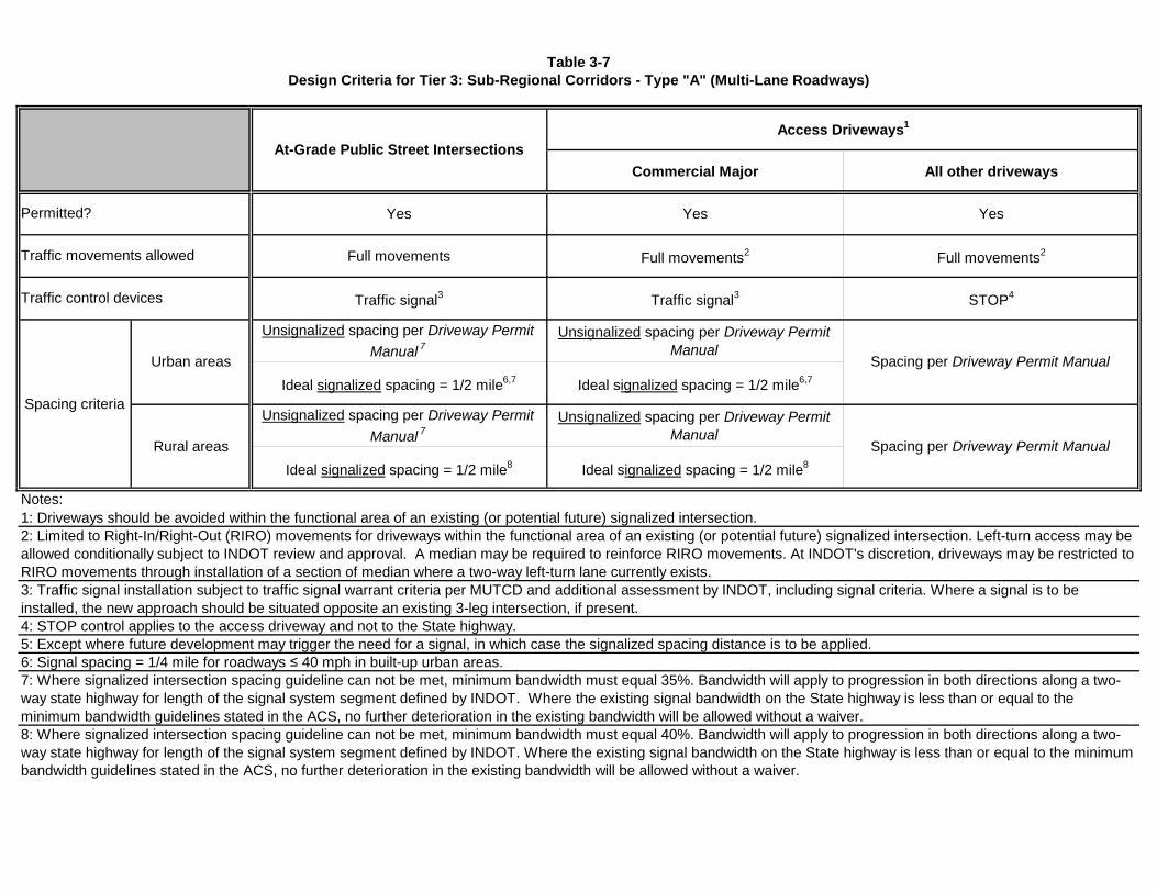
Commercial Major All other driveways
Yes Yes Yes
Full movements Full movements2 Full movements2
Traffic signal3 Traffic signal3 STOP4
Unsignalized spacing per Driveway PermitManual 7
Unsignalized spacing per Driveway PermitManual
Ideal signalized spacing = 1/2 mile6,7 Ideal signalized spacing = 1/2 mile6,7
Unsignalized spacing per Driveway PermitManual 7
Unsignalized spacing per Driveway PermitManual
Ideal signalized spacing = 1/2 mile8 Ideal signalized spacing = 1/2 mile8
Notes:
Traffic movements allowed
Spacing criteria
Rural areas Spacing per Driveway Permit Manual
Traffic control devices
Urban areas Spacing per Driveway Permit Manual
Table 3-7Design Criteria for Tier 3: Sub-Regional Corridors - Type "A" (Multi-Lane Roadways)
Permitted?
At-Grade Public Street IntersectionsAccess Driveways1
7: Where signalized intersection spacing guideline can not be met, minimum bandwidth must equal 35%. Bandwidth will apply to progression in both directions along a two-way state highway for length of the signal system segment defined by INDOT. Where the existing signal bandwidth on the State highway is less than or equal to theminimum bandwidth guidelines stated in the ACS, no further deterioration in the existing bandwidth will be allowed without a waiver.8: Where signalized intersection spacing guideline can not be met, minimum bandwidth must equal 40%. Bandwidth will apply to progression in both directions along a two-way state highway for length of the signal system segment defined by INDOT. Where the existing signal bandwidth on the State highway is less than or equal to the minimumbandwidth guidelines stated in the ACS, no further deterioration in the existing bandwidth will be allowed without a waiver.
5: Except where future development may trigger the need for a signal, in which case the signalized spacing distance is to be applied.4: STOP control applies to the access driveway and not to the State highway.
3: Traffic signal installation subject to traffic signal warrant criteria per MUTCD and additional assessment by INDOT, including signal criteria. Where a signal is to beinstalled, the new approach should be situated opposite an existing 3-leg intersection, if present.
1: Driveways should be avoided within the functional area of an existing (or potential future) signalized intersection.2: Limited to Right-In/Right-Out (RIRO) movements for driveways within the functional area of an existing (or potential future) signalized intersection. Left-turn access may beallowed conditionally subject to INDOT review and approval. A median may be required to reinforce RIRO movements. At INDOT's discretion, driveways may be restricted toRIRO movements through installation of a section of median where a two-way left-turn lane currently exists.
6: Signal spacing = 1/4 mile for roadways 40 mph in built-up urban areas.

Commercial Major All other driveways
Yes Yes Yes
Full movements Full movements2 Full movements2
Traffic signal3 Traffic signal3 STOP4
Unsignalized spacing per Driveway PermitManual 7
Unsignalized spacing per Driveway PermitManual
Ideal signalized spacing = 1/2 mile6,7 Ideal signalized spacing = 1/2 mile6,7
Unsignalized spacing per Driveway PermitManual 7
Unsignalized spacing per Driveway PermitManual
Ideal signalized spacing = 1/2 mile8 Ideal signalized spacing = 1/2 mile8
Notes:
Traffic control devices
Urban areas
Traffic movements allowed
Spacing per Driveway Permit Manual
7: Where signalized intersection spacing guideline can not be met, minimum bandwidth must equal 35%. Bandwidth will apply to progression in both directions along a two-way state highway for length of the signal system segment defined by INDOT. Where the existing signal bandwidth on the State highway is less than or equal to theminimum bandwidth guidelines stated in the ACS, no further deterioration in the existing bandwidth will be allowed without a waiver.8: Where signalized intersection spacing guideline can not be met, minimum bandwidth must equal 40%. Bandwidth will apply to progression in both directions along a two-way state highway for length of the signal system segment defined by INDOT. Where the existing signal bandwidth on the State highway is less than or equal to the minimumbandwidth guidelines stated in the ACS, no further deterioration in the existing bandwidth will be allowed without a waiver.
6: Signal spacing = 1/4 mile for roadways 40 mph in built-up urban areas.
Table 3-8Design Criteria for Tier 3: Sub-Regional Corridors - Type "B" (Two-Lane Roadways)
At-Grade Public Street IntersectionsAccess Driveways1
Permitted?
Spacing criteria
4: STOP control applies to the access driveway and not to the State highway.
1: Driveways should be avoided within the functional area of an existing (or potential future) signalized intersection.
3: Traffic signal installation subject to traffic signal warrant criteria per MUTCD and additional assessment by INDOT, including signal criteria. Where a signal is to beinstalled, the new approach should be situated opposite an existing 3-leg intersection, if present.
5: Except where future development may trigger the need for a signal, in which case the signalized spacing distance is to be applied.
Rural areas Spacing per Driveway Permit Manual
2: Limited to Right-In/Right-Out (RIRO) movements for driveways within the functional area of an existing (or potential future) signalized intersection. Left-turn access may beallowed conditionally subject to INDOT review and approval. A median may be required to reinforce RIRO movements. At INDOT's discretion, driveways may be restricted toRIRO movements through installation of a section of median where a two-way left-turn lane currently exists.

September 2009INDOT Access Management Guide – REVISED Indiana Department of Transportation
AECOM Transportation New York, New York42
3.3 Other Design Considerations
3.3.1 Guidelines for Crossroad Access Control
It is particularly important to protect the functional integrity of major crossroad intersections along Statehighways (e.g., intersections of State highways with either other State highways, or with major localstreet intersections). This can be accomplished by managing driveway access within the functional areaof such intersections. The functional area extends beyond the physical intersection of the State highwayand the crossroad to include the upstream approaches on the State highway and the crossroad (wheredeceleration, maneuvering and queuing takes place), as well as the downstream departure area beyond theintersection (where potential driveway conflicts occur that could generate queues backing up through themajor intersection).
Figure 3-1 and Table 3-9 provide guidance for determining the functional distances (i.e., distances “A”through “D”, as shown in Figure 3-1) both upstream and downstream of major intersections on both theState highway and the crossroad.
Table 3-9 identifies PIEV + Maneuver distances as a function of speed. The queue length should beadded to the distances shown in Table 3-9 to calculate the total functional length on State highwayapproaches at major intersections.
3.3.2 Median Length on Intersection Approaches
INDOT may choose to install non-traversable medians on State highway approaches at majorintersections, to reduce conflicts associated with left-turns into and out of adjacent driveways and protectthe functional integrity of these key intersections. The following guideline—based on the intersectionfunctional area calculations (see Figure 3-1 and Table 3-9)—is recommended for calculating the requiredlength of a non-traversable median on an intersection approach along a State highway:
Median Length = (PIEV distance + Maneuver distance) + Queue
Where:o PIEV distance = Distance traveled during Perception-Identification-Evaluation-Volition
(commonly referred to as “Perception-Reaction distance)
o Maneuver distance = Distance traveled while maneuvering and decelerating to a stop.
o Queue:For existing and planned future traffic signals = 95th percentile back-of-queuelength for the approach lane group with the longest queueFor unsignalized intersections = 200 feet
The queue length, described above, should be added to the PIEV + Maneuver distances in Table 3-9 tocalculate the total length of the median on State highway approaches at major intersections.

September 2009INDOT Access Management Guide – REVISED Indiana Department of Transportation
AECOM Transportation New York, New York43
Figure 3-1: Crossroad Access Control Guidelines based on Intersection Functional Area
“A” = (PIEV + Maneuver distance)* + QueueWhere:
PIEV distance = Distance traveled during Perception-Reaction-Evaluation-Volition(commonly referred to as “perception-reaction distance”)Maneuver distance = Distance traveled while maneuvering and decelerating to a stop.Queue = For existing and future traffic signals: 95th percentile back-of-queue for longestlane group queue
= For unsignalized intersections: 200 feet
“B” = For roadways where a non-traversable median is present, or access is restricted to right-in/right-out:
“B” = unsignalized spacing distance (based on AASHTO stopping sight distance)For all other roadways:
“B” = “A”
“C” = Greater of:95th percentile back-of-queue for longest lane group queueORUnsignalized spacing distance (based on AASHTO stopping sight distance)
“D” = Unsignalized spacing distance (based on AASHTO stopping sight distance)
*See Table 3-9
Note: Lot depth may prevent driveway spacing on the crossroad from being achieved. In these cases, thespacing of the driveway on the State highway should be maximized.

September 2009INDOT Access Management Guide – REVISED Indiana Department of Transportation
AECOM Transportation New York, New York44
Table 3-9: PIEV and Maneuver Distances
(mph)25303540455055606570 980
(feet)200230280330
550680780880
PIEV + ManeuverDistanceSpeed
430
Source: Adapted from INDOT Design Manual, Figure 46-4J: Deceleration Distance for Turn Lane
3.3.3 Locations for New Breaks in Controlled Access
INDOT is requested at times to allow new breaks in limited access rights-of-way along State highways.Although a break in access may be justifiable at certain key locations to relieve traffic congestion andincrease capacity at nearby intersections, there is a long-term opportunity cost associated with breakingthe limited access right-of-way.
Any breaks in limited access rights-of-way along State highways must be approved by the FederalHighway Administration (FHWA) where the right-of-way has been acquired using Federal funds.
The following are recommended provisions for identifying under what conditions breaks in controlledaccess should be allowed. The intent is that all of the provisions described below would apply to aparticular site. In addition, these provisions are intended to apply to all Tiers of the State highway accessclassification system (excluding limited-access facilities). These provisions apply only to new breaks,and do not apply to alterations (e.g., shifting of, or consolidation of) existing breaks.
Site / Property ConditionsThe property was landlocked (i.e. no alternative access) as a result of actions taken beyondINDOT’s control (as a result, the local agency involved would need to provide accommodationsfor access); andThe property was not subdivided, following INDOT’s purchase of access rights, to create a parcelthat would be landlocked.
Access Driveway ConditionsThe proposed access location is outside of the functional area2 of the upstream and downstreamintersections, based on a future (e.g. 10 year) traffic projection;Only right-in/right-out (RIRO) movements will be allowed at the access, and acceleration anddeceleration lanes will be provided.There are no provisions for future signalization, or allowances for additional movements (i.e. left-turns);
2 See functional area description in Figure 3-1 and Table 3-9.

September 2009INDOT Access Management Guide – REVISED Indiana Department of Transportation
AECOM Transportation New York, New York45
The access may be temporary until a supporting street system can be developed that providesalternative access; andINDOT determines that providing the access will result in traffic operations or safety benefitsfrom an overall system perspective.
September 2009INDOT Access Management Guide – REVISED Indiana Department of Transportation
AECOM Transportation New York, New York46
4.0 ACCESS MANAGEMENT TECHNIQUES
This section of the Guide describes various techniques to help implement access management withinIndiana, including the use of retrofit techniques and the preparation of Access Management Plans.
4.1 Retrofit Techniques
Access management improves traffic safety and protects the public’s investment in the road system bypreserving its functional integrity. Its focus is to minimize disruptions to the through traffic that wouldreduce the highway’s safety and efficiency. Access management is best implemented by applying criteriabased on established traffic engineering and roadway design principles. However, there may beconstraints in built-up areas that would limit the application of the access management criteria. Thissection provides guidance on access management techniques that can be used in situations where it is notpossible to achieve the desired access criteria. These are commonly referred to as “retrofit” situations.
4.1.1 When and where should retrofit apply?
The design criteria described in this Guide identify the desired outcome for access connections to theState highway system. However, in areas that are fully developed, it may not be possible to achieve thesedesired conditions. For example, block widths and mid-block alleys in some urban areas may rule outachieving the spacing standards. Elsewhere, there may be many pre-existing driveways and patterns ofland ownership that make it difficult to achieve the desired access location criteria. In these cases, retrofittechniques should be used to the maximum extent feasible to accomplish INDOT’s access policy goals.
4.2.1 Basic Principles for Improving Access Management in Retrofit Projects
The basic principles of access management described previously in this Guide apply to retrofit situationsas well, with an emphasis on the following:
Limiting direct access to State highways and other major roadways.Preserving the functional area of intersections and interchanges.Limiting the number of driveways and other conflict points.Separating driveways and other conflict points.Removing turning vehicles from through lanes.Using non-traversable medians to manage left-turn movements.Provide a supporting local street system and on-site circulation systems.Providing sufficient spacing between at-grade intersections.Providing adequate on-site storage areas.Encouraging access to street with the lowest functional classification where this option exists.
Appendix “B” of this Guide summarizes various retrofit techniques and provides illustrations of theirapplication. The retrofit techniques in Appendix “B” are divided into two categories:
1) Access/Driveway Location and Operation2) Roadway Design
To the extent feasible, the retrofit techniques under both categories should be applied by INDOT as partof driveway permit review and roadway reconstruction projects.

September 2009INDOT Access Management Guide – REVISED Indiana Department of Transportation
AECOM Transportation New York, New York47
4.2 Access Management Plans
An access management plan (AMP) is useful for dealing with areas that are undeveloped or areas whereredevelopment is possible. An AMP may be a stand-alone document, or prepared as part of sub-area orcorridor plan. The agency lead in preparing an AMP may be INDOT, an MPO, or a local government.The plan essentially focuses on a specific area, of smaller geographic scale than a statewide or MPO plan.It may address, for example, several communities or areas with roadways that are projected to be or are inneed of improvement. An AMP is prepared as an integral component of area-wide plans or as anindependent effort, and should incorporate provisions for coordination of area growth with developmentof the roadway network and any required traffic mitigation. An AMP relates to both comprehensive (thatis, area-wide) transportation planning and to detailed construction plans.
4.2.1 Features of an Access Management Plan
As stated in NCHRP 548: A Guidebook for Including Access Management in Transportation Planning, apublication of the National Cooperative Highway Research Program of the Transportation ResearchBoard (Reference 9), an AMP has several important features:
It is designed to achieve better long-range planning for highway access. It enables the State,MPO, county and/or local jurisdictions to specify, in advance, where access in a given area oralong a given stretch of highway can be provided. It also enables these agencies to identifycurrent access problems and to work toward their alleviation.
It provides a coherent frame of reference for developers and local governments. It provides apredictable and consistent basis by which to plan and locate access points, thereby introducingaccess considerations into the local planning process. It gives property owners guidance forsharing access between two adjacent lots, consolidating access for contiguous lots, and obtainingalternative access via collector streets, local streets, or frontage roads.
It can lead to a higher density of development from the improved road capacity resulting frombetter traffic management. This translates into higher land values.
It can facilitate the administration of access regulations and the issuance of driveway permits. Itassists municipalities and developers by defining the conditions under which driveway permitswill be issued. A developer can use the plan to establish permissible access points and can beassured that access permits will be forthcoming where access conforms to the plan.
The AMP should be a clear and concise document. It should include a map and an accompanying reportshowing where and how access can be provided, specifying how development and associated roadwaynetwork changes should be implemented, and indicating who is to be responsible for which elements.
4.2.2 Major Steps in Preparation of an Access Management Plan
As stated in NCHRP 548 (Reference 9), the major steps involved in preparing an Access ManagementPlan are the following:
Identify the study area and participating agencies/stakeholders.

September 2009INDOT Access Management Guide – REVISED Indiana Department of Transportation
AECOM Transportation New York, New York48
Develop a public involvement plan that will engage interested parties and consider differentopinions for the future of the corridor to shape a realistic plan.
Establish a vision and supporting goals and objectives to provide a basis for weighing variousoptions.
Perform policy, land use, and traffic analyses to provide a basis for the development of alternativeoptions and the selection of the components to include in the access management plan. Thefollowing questions should be explored:
o What problems need to be resolved?o What methods of access management may be used to help resolve these problems?o Are auxiliary lanes needed in certain locations?o Are there problems with traffic signal locations and traffic progression?o Does an existing median need to be improved or should a non-traversable median be
incorporated into the roadway design?o Is there a supporting street network?o Are there opportunities for shared access or inter-parcel circulation?o How can the supporting street and circulation system be modified or developed to
improve corridor safety and operations?
Evaluate options based on potential social, economic, and environmental impacts as well asspecific impacts on the following:
o Roadway safety;o Roadway efficiency and operation;o The supporting road network;o Accessibility of neighborhoods and commercial areas; ando Diversion of non-local trips through an existing residential area.
Establish the responsibilities of each of the participants for the improvements contemplated bythe plan.
Identify the manner in which the timing and sequence of construction of the improvements are tobe implemented.
Provide, if necessary, for temporary access pending completion of the improvements.
Identify expected future mitigation measures, including traffic limitations and lots with“nonconforming” access (as in Florida and New Jersey).
4.2.3 Issues to Address in an Access Management Plan
As stated in NCHRP 548 (Reference 9), the following issues should be addressed in an AccessManagement Plan:
Inter-governmental collaboration. The defining characteristic of a successful AMP is the level ofcooperation achieved among affected property owners and agencies involved in carrying out theplan.
September 2009INDOT Access Management Guide – REVISED Indiana Department of Transportation
AECOM Transportation New York, New York49
Access plans can also be incorporated into the project through the National EnvironmentalProtection Act, road design, and public involvement processes and documents.
Providing incentives that encourage local governments to initiate and develop plans. Incentivescould include state and local sharing of costs and facilitation of the permit review process.
Requires supporting land use actions by local jurisdictions.
Phasing in new access approaches. The issuance of temporary access permits is one strategy forphasing and adjusting access as an area develops or is redeveloped. A temporary permit canspecify when a temporary driveway is to be removed and a permanent driveway installed. Thisrequires careful planning and coordination and a clear understanding of who pays for what.

September 2009INDOT Access Management Guide – REVISED Indiana Department of Transportation
AECOM Transportation New York, New York50
5.0 INTER-GOVERNMENTAL COORDINATION
The need for coordination between INDOT and local governments with respect to land use andtransportation decisions cannot be understated. This section of the Guide addresses the role of localjurisdictions, their relationship to INDOT, and the need for coordinated decision-making with respect toaccess management.
5.1 Current Practices and the Need for Coordination
In Indiana, access management is a prerogative of local government that varies in the level of exercisefrom no access control requirements, to access management standards that may, on occasion, be morerestrictive than INDOT. Under general enabling legislation for municipalities (IC 36-9-2 and 36-9-6),counties (IC 8-17-1 and 8-20) and all levels of government (IC 9-21), local governments may requirepermits for private access to public roadways. A secondary means of access management by localjurisdictions is through land use controls (zoning per IC 36-7-4-600 series, subdivisions per IC 36-7-4-700 series and site plan review per IC 36-7-4-1400 series) where requested permission to expand a landuse right may trigger a review of roadway access to the subject property. Historically, the relationshipsbetween State and local jurisdictions regarding access management have been informal and found to varywidely throughout Indiana.
Although the review and approval of applications for driveway access to abutting State roadways isprimarily the responsibility of INDOT (as described in Section 2.0), site plan review and approval are theresponsibility of local governmental agencies. Although in some cases the permit review and site planreview processes are well-coordinated between INDOT and the local jurisdiction, the more frequent lackof coordination jeopardizes the ability of both agencies to manage access properly, which can havedetrimental effects on the operations and safety of the highway system.
Sometimes problems begin with the local agency responsible for local land use planning, zoning, and siteplan review. Site plans are approved without the county or municipality requesting an independentreview by INDOT. As a result, the number and spacing of driveways, and the placement of buildings andparking areas, essentially become fixed, leaving INDOT with little or no opportunity for recourse.
It is not uncommon for developers and property owners to use this lack of inter-agency coordination totheir advantage, pressuring one agency to take action only after approvals have been issued by the otheragency. In addition, the INDOT driveway permit process can be avoided by the developer in cases whereno direct site-access to a State highway is proposed. Although much of the traffic associated with thedevelopment may use the State highway, INDOT is limited in its ability to require mitigating measures tocompensate for this additional traffic.
The conflict between vehicle movement and land access increases as development continues in bothurban and rural areas. The challenge is how best to coordinate vehicular access with land development ina way that encourages economic activity while simultaneously preserving mobility and providingadequate property access. The principles of access management, described in Section 1.3 of this Guide,address these competing needs.
Land use planning and development review all take place at the local level where the authority resides. Akey objective of the transportation process, therefore, is to coordinate transportation and land use. This isespecially important for access management and corridor preservation. The actions of local jurisdictionsin planning, reviewing, and approving land development can significantly impact the ability of otheragencies to implement their transportation plans. A key feature of successful access management iscoordination with land use decisions made by local jurisdictions. As illustrated in Figure 5-1, successful

September 2009INDOT Access Management Guide – REVISED Indiana Department of Transportation
AECOM Transportation New York, New York51
land use planning and traffic management requires integrated planning efforts and other related actions atboth the State and local levels.
Figure 5-1: Relationships between State and Local Agenciesin Land Use/Transportation Planning Process
Source: Exhibit 3-1 from NCHRP 548: A Guidebook for Including Access Management in Transportation Planning, 2005.
A critical element of access management is the land use authority of Indiana’s local units of government.While INDOT is responsible for state highways, land use decisions for adjacent and nearby properties aremost often made by the local governments. Local planning, zoning, and elected officials are thecommunity land use decision-makers. They ensure new development is consistent with local land use (ormaster) plans, compatible with other land uses in the community, and in compliance with localregulations. These local officials are responsible for assessing the affects of land use decisions withintheir community’s borders, but not beyond. Consequently, the local development review process is oftensegregated. In other words, local officials often review development plans without consulting theappropriate road agency (city, county or INDOT) responsible for managing access in their area. Throughzoning, subdivision regulations, condominium regulations, private road regulations, and building codes,local governments can approve new developments with, or without, considering the impact on access.
Many local governments may not be well informed of INDOT’s driveway permitting requirements. Theyalso may know little about how development decisions affect the safety and function of state highwaysand other roads. Moreover, the process of access permitting often does not occur until after land usedecisions are made. As a result, INDOT and other road agencies often have little, if any, input regardingland use decisions. This can result in frustration among all participants if project design changes areneeded to obtain a driveway permit. If access problems are identified too late in the decision process,some solutions that may have worked earlier in the design stage may no longer be options. Simplyinvolving INDOT or the local road agency early in the process of planning and reviewing a developmentcan produce many benefits, because access-related issues can be raised earlier and solutions more easilyidentified.

September 2009INDOT Access Management Guide – REVISED Indiana Department of Transportation
AECOM Transportation New York, New York52
No laws or regulations in Indiana require local planning, zoning and building permitting agencies tocoordinate their efforts with INDOT. However, some local governments have worked out informalprocedures with INDOT district offices. In these instances, it is usually because the local government hasprofessional staff or consultants able and available to coordinate the process.
5.2 Opportunities for Coordinated Access Management
Better project review coordination between INDOT and local governments leads to better accessmanagement. Better access management allows motorists to conveniently and safely access their homesand local businesses with fewer delays. If local permit procedures are coordinated with INDOT drivewaypermit procedures, many access-related conflicts and issues can be avoided.
5.2.1 Benefits of Coordinated Decision-making
Coordinated land use and access management decision-making can:
Prevent conflicts involving the community, developer, and INDOT created because:
1) A driveway permit was issued by INDOT before local site plan review has been completed.
2) The community approved a site plan or building permit before determining if a drivewaypermit has been issued by INDOT.
Build professional relationships based on a common understanding of local road issues, which inturn can improve cooperation and mutual support on future maintenance, remedial and/orimprovement projects.
Prevent unnecessary redesign, which typically results in higher development costs.
5.2.2 Basic Elements of Coordinated Decision-making
The key elements of coordinated decision making are:
All relevant government agencies reviewing proposed projects at the same time,
Compatible standards, and
Conditioning approval of each permit upon the receipt of required permits issued by otherapproving authorities.
Figure 5-2 shows the typical segregated project review procedures used by many local governments androad agencies, as well as an alternative procedure used in some communities to coordinate developmentreviews with INDOT and other appropriate road authorities.
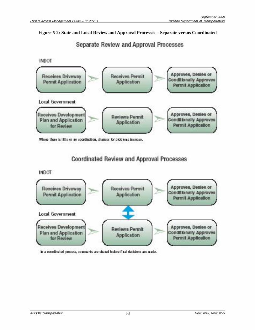
September 2009INDOT Access Management Guide – REVISED Indiana Department of Transportation
AECOM Transportation New York, New York53
Figure 5-2: State and Local Review and Approval Processes – Separate versus Coordinated
September 2009INDOT Access Management Guide – REVISED Indiana Department of Transportation
AECOM Transportation New York, New York54
Coordinated decision-making requires that INDOT and other road agencies review proposed site plans formost projects at the same time they are being reviewed by local authorities. Very large projects should gothrough a two-step review process, where the developer meets with INDOT (and other road authorities)and local government officials early in the project design process. At the discretion of local officials,these preliminary site plan review meetings should be conducted together with the appropriate roadauthorities.
If local zoning authorities have no access management standards, compatibility of standards is not anissue. But if there are local access management regulations, and they conflict with INDOT’s standards,then in most cases, the developer must comply with the most stringent regulations. If INDOT or theresponsible road authority is not aware of local standards, they could issue a driveway permit that isinconsistent with local requirements.
By conditioning local site plan approval on receipt of required permits from the responsible roadauthority, the local government will assure compliance of the project with INDOT standards and/or thoseof other road agencies. Similarly, INDOT and local agencies that condition approval of their permits withlocal land use standards will help assure new development does not violate local zoning and relatedrequirements.
Coordination between road authorities and local land use authorities is the best way to ensure that futureland use decisions protect motorists and the public’s investment in Indiana’s highways. Coordinatedaccess management reduces traffic crashes and congestion, provides people with easy access to and fromhomes and businesses, allows roads to carry the volume of traffic they were designed for, and helpscommunities grow and prosper.
5.3 Access Management Assistance for Local Agencies
Appendix “A” of this Guide provides two model access management ordinances for use by localgovernments. These model ordinances are intended to help guide efforts to implement accessmanagement techniques that are best enacted through a local ordinance adopted by the local legislativebody (city or town council or board of county commissioners), implemented through the city/town publicworks department (office of the city engineer) or the county highway department (office of countyengineer) and reinforced through local land use controls such as zoning, subdivision and site plan reviewregulations.
5.4 Memorandum of Understanding for Intergovernmental Cooperation
It is generally in the mutual interest of INDOT and local governments to coordinate the approval of thelocation and design of access driveways serving properties abutting, and in proximity to, the Statehighway system, with the review and approval of developments and the subdivision of land. To this end,language for a Memorandum of Understanding (MOU) has been drafted to help formally establish anddocument agreements between INDOT and local governments with respect to access management andlocal land use controls. The draft language for the MOU document is included as Appendix “E”.
As part of the MOU, INDOT agrees to:
Notify the local public agency of applications for driveway or right-of-way encroachment permitsfrom developers, to ensure the developer has, or will, comply with local land use regulationsrelative to local development review and approval. This is intended to coordinate the review of

September 2009INDOT Access Management Guide – REVISED Indiana Department of Transportation
AECOM Transportation New York, New York55
INDOT and the local public agency to ensure the approval of one party does not occur withoutthe knowledge and input of the other.
Notify the local public agency of agreements with developers concerning future signalization,roadway improvements, and access control restrictions. This will enable the local public agencyto help INDOT with agreement enforcement.
Notify the local public agency about planned roadway improvements prior to the execution ofdesign contracts, so that existing and planned crossroad improvements, and access managementto abutting properties, may be addressed in the scope of design.
Involve the local public agency in design plan review before the roadway design is finalized, andprior to any public meetings or hearings, so that the treatment of existing and planned crossroadimprovements and access management to abutting properties may be reviewed.
As part of the MOU, the local public agency agrees to:
Notify INDOT in the event of any of the following land use actions:
o Proposed major residential subdivisions or land use re-zonings of properties abutting theState right-of-way, or with access via a local crossroad that has property with accesswithin a ¼-mile of the State right-of-way, and meeting INDOT warrants for a TrafficImpact Study.
o New land use approvals (including special exceptions, special uses, contingent uses,conditional uses or use variances) before the local board of zoning appeals whenproperties abut the State right-of-way.
o Proposals for minor residential subdivisions with direct access to State roadways.
Notify INDOT in the event of:
o Any local site plan reviews, and
o Any local review actions concerning commercial developments (apartments, retail,office, industrial or institutional) if the site abuts the State right-of-way, or if the siteaccess is via a local crossroad that has property with access within a ¼-mile of the Stateright-of-way and the site trip generation meets INDOT warrants for a Traffic ImpactStudy.
For all new buildings abutting State right-of-way (as well as expansions and changes to existingcommercial uses), coordinate the local building permit process with INDOT to ensure the existingdriveways can accommodate or be improved to accommodate additional site traffic.
Notify INDOT of dimensional variances (such as structure setbacks and height standards) oncorner properties of State/crossroad intersections to ensure preservation of corner sight trianglesand to avoid conflicts with traffic control devices.

September 2009INDOT Access Management Guide – REVISED Indiana Department of Transportation
AECOM Transportation New York, New York56
6.0 REFERENCES
1. Reducing Traffic Congestion and Improving Traffic Safety in Michigan Communities: The AccessManagement Guidebook, Planning & Zoning Center, Inc., October 2001.
2. Access Management Manual, Transportation Research Board, National Academy of Sciences,2003.
3. NCHRP 420: Impacts of Access Management Techniques, National Cooperative HighwayResearch Program, Transportation Research Board, 1999.
4. A Policy on Geometric Design of Highways and Streets, American Association of State Highwayand Transportation Officials (AASHTO), 2004.
5. Highway Capacity Manual, Committee on Highway Capacity and Quality of Service,Transportation Research Board, National Research Council, 1994.
6. Title 105, Article 7: Permits for Highways, Indiana Administrative Code.
7. Applicant’s Guide to Traffic Impact Studies, S. Dey and J. Fricker, Purdue University JointHighway Research Project in cooperation with the Indiana Department of Transportation and theU.S. Department of Transportation – Federal Highway Administration, June 1993.
8. Driveway Permit Manual, Indiana Department of Transportation, 1996.
9. NCHRP 548: A Guidebook for Including Access Management in Transportation Planning,National Cooperative Highway Research Program, Transportation Research Board, 2005.
September 2009INDOT Access Management Guide – REVISED Indiana Department of Transportation
AECOM Transportation New York, New York57
7.0 BIBLIOGRAPHY
1. NCHRP Synthesis 351: Access Rights, National Cooperative Highway Research Program,Transportation Research Board, 2005.
2. Review of SDDOT’s Highway Access Control Process, Study SD99-01: Final Report, DyeManagement Group, Inc., February 2000.
3. Roadway Design Manual, Indiana Department of Transportation, June 2003.

Appendix “A” – Sample Access Management Ordinances September 2009INDOT Access Management Guide – REVISED Indiana Department of Transportation
AECOM Transportation New York, New York
APPENDIX “A”SAMPLE ACCESS MANAGEMENT ORDINANCES
This appendix contains the following two model ordinances:
Kentucky Model Access Management Ordinance (Version 1.1, dated October 2004) from theKentucky Transportation Cabinet
Chapter 8, Sample Access Management Ordinances from the Michigan Access ManagementGuidebook (October 2001) from the Michigan DOT
These model ordinances are intended to help guide efforts to implement access management techniquesthat are best enacted through a local ordinance adopted by the local legislative body (city or town councilor board of county commissioners), implemented through the city/town public works department (officeof the city engineer) or the county highway department (office of county engineer) and reinforced throughlocal land use controls such as zoning, subdivision and site plan review regulations.

Appendix “A” – Sample Access Management Ordinances September 2009INDOT Access Management Guide – REVISED Indiana Department of Transportation
AECOM Transportation New York, New York
Appendix A-1Kentucky Model Access Management Ordinance
KentuckyModel Access Management
Ordinance
Version 1.1
October 2004
Developed by Brent A. SwegerDivision of Multimodal ProgramsKentucky Transportation Cabinet

Appendix “A” – Sample Access Management Ordinances September 2009INDOT Access Management Guide – REVISED Indiana Department of Transportation
AECOM Transportation New York, New York
Part 1Overview
Introduction
The Kentucky Model Access Management Ordinance has been adapted from the Florida Model LandDevelopment & Subdivision Regulations That Support Access Management, developed by the Center forUrban Transportation Research and the Florida DOT. This model ordinance is provided to assistKentucky cities and counties in developing access management ordinances to further improve safety andtraffic flow efficiency of Kentucky’s roadways. Although the ordinance does not cover all accesstreatments, it does cover the most-used treatments. Municipalities are urged to tailor the ordinance tomeet local needs and develop additional language as necessary.
Overview
Effective local access management requires planning as well as regulatory solutions. Where applicable,communities should establish a policy framework that supports access management in the localcomprehensive plan, prepare corridor or access management plans for specific problem areas, andencourage good site planning techniques. Land development and subdivision regulations should beamended accordingly. Communities may also consider a separate access management ordinance. Accessmanagement programs should address commercial development along thoroughfares, as well as flag lots,residential strips, and other issues related to the division and subdivision of land. Comprehensive and sub-area plans provide the rationale for access management programs and can serve as the legal basis forpublic policy decisions.
Communities are increasingly concerned about the effects of development on service costs, communitycharacter, and overall quality of life. Yet conventional regulatory practice has played a role inperpetuating land development problems. Nowhere is this more apparent than the cycle of functionalobsolescence created by strip commercial development along major arterials. The practice of strip zoningmajor corridors for commercial use is widespread across Kentucky. The primary reasons are accessibilityand the expedience of rezoning highway frontage for commercial use as additional land is needed.Extension of utilities along highway rights-of-way promotes this linear land use pattern, and commercialbusinesses favor corridor locations because of the ready supply of customers.
Yet as development intensifies along a roadway, the growing number of curb cuts and turning movementsconflict with the intended function of arterials: to move people and goods safely, quickly, and efficiently.Unlike urban downtowns or activity centers, commercial strips are rarely designed for pedestrians ortransit. Commercial corridors, residential areas, and office parks are frequently sealed off from each otherwith walls, ditches, loading docks and a host of other barriers—including the heavily traveled arterialsthat serve them.
Poorly coordinated access systems force more trips onto the arterial, traffic conflicts multiply, andcongestion increases. As the level of service declines, additional lanes, controlled medians, and otherexpensive retrofitting measures are needed to maintain the capacity of the corridor for regional traffic.Businesses also suffer as accessibility deteriorates. Heavy traffic, difficult left turns, and poor sightclearance at corners deter customers. Businesses may relocate to areas where accessibility is lessimpaired, causing increased vacancies and declined property values in the area from where they moved.Eventually the corridor is transformed into an unattractive and confusing jumble of signs, curb cuts,
Appendix “A” – Sample Access Management Ordinances September 2009INDOT Access Management Guide – REVISED Indiana Department of Transportation
Urbitran Associates, Inc. New York, New York
utility lines, and asphalt.
These are not inevitable results of development and growth. Rather, they relate to the lack of adequateland division and access controls and problems inherent in current planning and regulatory practice. Thisreport examines the role of the comprehensive plan in developing an access management program,aspects of current regulatory practice that contribute to access problems, and regulatory techniques thatsupport access management principles.
The Comprehensive Plan
The local comprehensive plan is the policy and decision making guide for future development and capitalimprovements in the municipality or county. It analyzes development trends; identifies key planningissues; provides the policy framework; and specifies strategies for carrying out the plan. Purposes of theplan are to:
promote orderly and efficient development;protect property values;preserve community character, natural resources, and the environment;promote economic vitality; andincrease public awareness of the forces of community change.
Local comprehensive plans should establish how the community will balance mobility with access,identify the desired access management approach, and designate corridors that will receive specialtreatment. This may be supplemented through functional plans, such as an access management orthoroughfare plan, or through sub-area plans, such as an interchange or corridor plan.
The comprehensive planning process is an opportunity to increase community awareness of the forces ofchange and determine a strategic course of action. What level of growth can the community expect? Whatare the future land use and capital improvement needs? And what type of land development patterns docitizens prefer? Public opinion surveys, town meetings, and visioning workshops may be used to identifycitizen concerns and build political support for regulatory change. Citizen dissatisfaction with commercialstrips, for example, can be translated into policies for joint access, shared parking, and sign regulation.When evaluating future land use needs, communities should account for vacancies and surplus landalready available for that use. Many communities set aside far more land than required to accommodatereasonable estimates of growth, thereby encouraging scattered development patterns and stripdevelopment. It is not uncommon for communities to strip zone the majority of their highway frontage forcommercial use. Additional highway frontage should not be planned or rezoned for commercial usewhere vacant or surplus commercial space is already available. This encourages reuse of existingcommercial sites, increases property values in those areas, and is a long term economic developmentstrategy.Some cities have incorporated these planning and access management principles into their comprehensiveplan. Examples of these principles include:
designated mixed-use corridors, rather than commercial strips;mandatory mixed use with transit access in activity centers;limiting the supply of commercial areas to encourage reuse;designated cross access corridors with joint access requirements;comprehensive access classification and driveway spacing;policies and standards relating to bicycle and pedestrian access.
Appendix “A” – Sample Access Management Ordinances September 2009INDOT Access Management Guide – REVISED Indiana Department of Transportation
Urbitran Associates, Inc. New York, New York
Subdivision Regulations
Subdivision regulations help ensure:
proper street layout in relation to existing or planned roadways;
adequate space for emergency access and utilities;
adequate water, drainage, and sanitary sewer facilities;
appropriate site design.
The subdivision ordinance establishes:
the administrative review and evaluation procedure for processing conceptual, preliminary, andfinal plats
information that must be included on the plat
design principles and standards for lots, blocks, streets, public places, pedestrian ways, andutilities
required improvements, including streets, sidewalks, water, sewer, and curbs and gutters;
financing and maintenance responsibilities.
The subdivision review process should address a variety of issues, including these transportationrelated issues:
Is the road system designed to meet the projected traffic demand and does the road networkconsist of hierarchy of roads designed according to function?
Is access properly placed in relation to sight distance, driveway spacing, and other relatedconsiderations?
Do units front on residential access streets rather than major roadways?
Does the project avoid areas unsuitable for development?
Does the pedestrian path system link buildings with parking areas, entrances to the development,open space, and recreational and other community facilities?
Have utilities been properly placed?
State subdivision statutes grant local governments authority to regulate subdivision of land and establishminimum requirements for subdividing and platting. Subdivision is defined as the division of land intotwo or more parcels and provides exceptions only in special circumstances.
Yet many local subdivision statutes exempt division of land into larger parcels or creation of a smallnumber of lots from review and conformance with subdivision. These plans evaluate long term trends;

Appendix “A” – Sample Access Management Ordinances September 2009INDOT Access Management Guide – REVISED Indiana Department of Transportation
Urbitran Associates, Inc. New York, New York
provide data on traffic accidents and related considerations; and establish the relationship between accessmanagement and other community objectives, such as congestion management and transportation level ofservice. By establishing the relationship between regulatory strategies and public health, safety, andwelfare, these plans can serve as the legal basis for access controls.
Corridor Overlay Zones
Overlay zones are a method for managing access along commercial corridors. The technique is used tooverlay a special set of requirements onto an exiting zoning district, while retaining the underlying zoningand its associated requirements. Text that specifies standards for the access management overlay districtis included in the land development (or zoning) code and then corridors are designated on the zoning map.Overlay requirements may address any issues of concern such as joint access, parking lot cross access,reverse frontage, driveway spacing and limitation on new driveways. See Section 14 of the ModelRegulations for corridor overlay standards.
Model Ordinance
Features of the model ordinance include classification of roadways by function and requirements for sightdistance, driveway spacing, maximum driveways per lot, corner lot access, corner clearance, shared (jointand cross) access, turn radius, driveway width, driveway throat length, and parking/loading. The modelordinance contains commentary to establish the logic behind the ordinance and assist the planner in thetailoring of the local ordinance. These commentaries should be stricken from the actual local ordinance.In addition, there are several areas within the ordinance marked in blue that should be replaced with theappropriate name of local agencies, documents, etc.
Conclusion
Access management, if implemented locally, addresses a broad array of quality of life issues fundamentalto promoting livable, prospering communities. Land division and access controls:
Foster well designed circulation systems that improve the safety and character of commercialcorridors;
Discourage subdivision practices that destroy the rural character of the landscape or essentialnatural resources;
Advance economic development goals by promoting more efficient use of land and transportationsystems;
Help control public service costs and the substantial public investment in infrastructure andservices.

Appendix “A” – Sample Access Management Ordinances September 2009INDOT Access Management Guide – REVISED Indiana Department of Transportation
Urbitran Associates, Inc. New York, New York
Part 2Model Regulations
Adapted for Indiana
Table of Contents
Section 1: Intent and PurposeSection 2: ApplicabilitySection 3: Conformance with Plans, Regulations, and StatutesSection 4: DefinitionsSection 5: Access Management Classification System and StandardsSection 6: Corner ClearanceSection 7: Joint and Cross AccessSection 8: Interchange AreasSection 9: Access Connection and Driveway DesignSection 10: Requirements for4 Outparcels and Phased Development PlansSection 11: Emergency AccessSection 12: Transit AccessSection 13: Nonconforming Access FeaturesSection 14: Corridor Access Management OverlaySection 15: Reverse FrontageSection 16: Flag Lot StandardsSection 17: Lot Width-to-Depth RatiosSection 18: Shared AccessSection 19: ConnectivitySection 20: Minor SubdivisionsSection 21: Private RoadsSection 22: Regulatory FlexibilitySection 23: Site Plan Review ProceduresSection 24: Variance Standards
Section 1: Intent and Purpose
The intent of this ordinance is to provide and manage access to land development, while preserving theregional flow of traffic in terms of safety, capacity, and speed. Major thoroughfares, including highwaysand other arterials, serve as the primary network for moving people and goods. These transportationcorridors also provide access to businesses and homes and have served as the focus for commercial andresidential development. If access systems are not properly designed, these thoroughfares will be unableto accommodate the access needs of development and retain their primary transportation function. Thisordinance balances the right of reasonable access to private property, with the right of the citizens of the(city/county) and the State of Indiana to safe and efficient travel.
To achieve this policy intent, state and local thoroughfares have been categorized by function andclassified for access purposes based upon their level of importance. Regulations have been applied tothese thoroughfares for the purpose of reducing traffic accidents, personal injury, and property damageattributable to poorly designed access systems, and to thereby improve the safety and operation of theroadway network. This will protect the substantial public investment in the existing transportation systemand reduce the need for expensive remedial measures. These regulations also further the orderly layout

Appendix “A” – Sample Access Management Ordinances September 2009INDOT Access Management Guide – REVISED Indiana Department of Transportation
Urbitran Associates, Inc. New York, New York
and use of land, protect community character, and conserve natural resources by promoting well-designedroad and access systems and discouraging the unplanned subdivision of land.
Section 2: Applicability
This ordinance shall apply to all arterials and selected collectors within (city/county) and to all propertiesthat abut these roadways. The access classification system and standards of the Indiana Department ofTransportation (INDOT) shall apply to all roadways on the state highway system.
Section 3: Conformance with Plans, Regulations, and Statutes
This ordinance is adopted to implement (cite specific policies) of the (city/county) as set forth in the(name local comprehensive plan). In addition, this ordinance conforms with (cite specific policies) of the(name of Metropolitan Planning Organization – if applicable) as specified in the (name of long rangetransportation plan – if applicable), and the planning policies set forth in the INDOT Long Range Plan.The ordinance also conforms to the access classification system and standards of INDOT, and policy andplanning directives of the Federal Highway Administration.
Commentary: The link between regulations and public policy has undergone intense legal scrutiny inrecent years. To establish this link, local governments should clearly identify the intent and purpose of theregulatory program, and specify any plans, state and federal regulations, or statutes that will be carriedout through the regulatory standards. It is also important to cite specific planning policies that are beingadvanced through these regulations. Local governments in designated transportation management areasmay also cite access management as a congestion management measure in accordance with the federaltransportation planning regulations. Communities that do not lie within the planning area boundaries ofa Metropolitan Planning Organization (MPO) would simply leave out the reference to MPOs in thissection. Demonstrating conformance with state and federal law, and with the local comprehensive plan,is important in strengthening the legal basis for any local regulatory program.
Section 4: Definitions
Access - A way or means of approach to provide vehicular or pedestrian entrance or exit to aproperty.
Access Classification - A ranking system for roadways used to determine the appropriate degreeof access management. Factors considered include functional classification, the appropriate localgovernment's adopted plan for the roadway, subdivision of abutting properties, and existing levelof access control.
Access Connection - Any driveway, street, turnout or other means of providing for themovement of vehicles to or from the public roadway system.
Access Management - The process of providing and managing access to land development whilepreserving the regional flow of traffic in terms of safety, capacity, and speed.
Access Management Plan (Corridor) - A plan illustrating the design of access for lots on ahighway segment or an interchange area that is developed jointly by the state, the metropolitanplanning organization, and the affected jurisdiction(s).
Cartway -That area of road surface from curb line to curb line or between the edges of the paved

Appendix “A” – Sample Access Management Ordinances September 2009INDOT Access Management Guide – REVISED Indiana Department of Transportation
Urbitran Associates, Inc. New York, New York
or hard surface of the roadway, which may include travel lanes, parking lanes, and deceleration oracceleration lanes.
Connection Spacing -The distance between connections, measured from the closest edge ofpavement of the first connection to the closest edge of pavement of the second connection alongthe edge of the traveled way.
Corner Clearance - The distance from an intersection of a public or private road to the nearestaccess connection, measured from the closest edge of the pavement of the intersecting road to theclosest edge of the pavement of the connection along the traveled way (see Figure A1-1)
Figure A1-1: Corner Clearance and Driveway Spacing
Corridor Overlay Zone - Special requirements added onto existing land developmentrequirements along designated portions of a public thoroughfare.
Cross Access - A service drive providing vehicular access between two or more contiguous sitesso the driver need not enter the public street system (see Figure A1-4)
Deed - A legal document conveying ownership of real property.
Directional Median Opening - An opening in a restrictive median which provides for specificmovements and physically restricts other movements. Directional median openings for twoopposing left or "U-turn" movements along a road segment are considered one directional medianopening.
Easement - A grant of one or more property rights by a property owner to or for use by thepublic, or another person or entity.
Frontage Road - A public or private drive which generally parallels a public street between theright-of-way and the front building setback line. The frontage road provides access to privateproperties while separating them from the arterial street. (see also Service Roads)

Appendix “A” – Sample Access Management Ordinances September 2009INDOT Access Management Guide – REVISED Indiana Department of Transportation
Urbitran Associates, Inc. New York, New York
Full Median Opening - An opening in a restrictive median that allows all turning movementsfrom the roadway and the intersecting road or access connection.
Functional Area (Intersection) - That area beyond the physical intersection of two controlledaccess facilities that comprises decision and maneuver distance, plus any required vehicle storagelength, and is protected through corner clearance standards and driveway connection spacingstandards (see Figure A1-2).
Figure A1-2: Functional Area of Intersection
Functional Classification - A system used to group public roadways into classes according totheir purpose in moving vehicles and providing access.
Joint Access (or Shared Access) - A driveway connecting two or more contiguous sites to thepublic street system.
Lot - A parcel, tract, or area of land whose boundaries have been established by some legalinstrument, which is recognized as a separate legal entity for purposes of transfer of title, hasfrontage upon a public or private street, and complies with the dimensional requirements of thiscode.
Lot, Corner - Any lot having at least two (2) contiguous sides abutting upon one or more streets,provided that the interior angle at the intersection of such two sides is less than one hundredthirty-five (135) degrees.

Appendix “A” – Sample Access Management Ordinances September 2009INDOT Access Management Guide – REVISED Indiana Department of Transportation
Urbitran Associates, Inc. New York, New York
Commentary: Corner lots can create confusion in relation to dimensional requirements. Therecommended approach is to designate one frontage as the "front" and the rear lot line would be thatopposite the designated frontage. Both portions of the lot with street frontage should still be required tomeet the required front yard setback to ensure adequate sight distance and consistency of setback withabutting properties. A lot abutting a curved street(s) is typically considered a corner lot if the arc has aradius less than one hundred and fifty (150) feet.
Lot Depth - The average distance measured from the front lot line to the rear lot line.
Lot, Flag - A large lot not meeting minimum frontage requirements and where access to thepublic road is by a narrow, private right-of-way or driveway.
Lot, Nonconforming - A lot that does not meet the dimensional requirements of the district inwhich it is located and that existed before these requirements became effective.
Lot, Through (also called a double frontage lot) - A lot that fronts upon two parallel streets orthat fronts upon two streets that do not intersect at the boundaries of the lot.
Lot Frontage - That portion of a lot extending along a street right-of-way line.
Lot of Record - A lot or parcel that exists as shown or described on a plat or deed in the recordsof the Clerk of the County Court.
Lot Width - The horizontal distance between side lot lines measured parallel to the front lot lineat the minimum required front setback line.
Manual of Uniform Traffic Control Devices (MUTCD) - A Federal document adopted by theKentucky Transportation Cabinet that provides standards for traffic control devices.
Minor Subdivision - A subdivision of land into not more than two (2) lots where there are noroadways, drainage, or other required improvements.
Nonconforming Access Features - Features of the access system of a property that existed priorto the date of ordinance adoption and do not conform to the requirements of this code.
Nonrestrictive Median - A median or painted centerline that does not provide a physical barrierbetween traffic traveling in opposite directions or turning left, including continuous center turnlanes and undivided roads.
Outparcel - A parcel of land abutting and external to the larger, main parcel, which is underseparate ownership and has roadway frontage.
Parcel - A division of land comprised of one or more lots in contiguous ownership.
Plat - An exact and detailed map of the subdivision of land.
Private Road - Any road or thoroughfare for vehicular travel which is privately owned andmaintained and which provides the principal means of access to abutting properties.

Appendix “A” – Sample Access Management Ordinances September 2009INDOT Access Management Guide – REVISED Indiana Department of Transportation
Urbitran Associates, Inc. New York, New York
Public Road - A road under the jurisdiction of a public body that provides the principal means ofaccess to an abutting property.
Reasonable Access: The minimum number of access connections, direct or indirect, necessary toprovide safe access to and from the thoroughfare, as consistent with the purpose and intent of thiscode and any applicable plans and policies of the (city/county).
Restrictive Median - A physical barrier in the roadway that separates traffic traveling in oppositedirections, such as a concrete barrier or landscaped island.
Right-of-Way - Land reserved, used, or to be used for a highway, street, alley, walkway,drainage facility, or other public purpose.
Service Road - A public or private street or road, auxiliary to and normally located parallel to acontrolled access facility, that maintains local road continuity and provides access to parcelsadjacent to the controlled access facility.
Significant Change in Trip Generation - A change in the use of the property, including land,structures or facilities, or an expansion of the size of the structures or facilities causing anincrease in the trip generation of the property.
State Primary Road System - The network of limited access and controlled access highwaysthat have been functionally classified and are under the jurisdiction of the Commonwealth ofKentucky.
Stub-out (Stub-street) - A portion of a street or cross access drive used as an extension to anabutting property that may be developed in the future.
Subdivision - Is the process and the result of any of the following:
a. The platting of land into lots, building sites, blocks, open space, public areas, or any otherdivision of land;
b. Establishment or dedication of a road, highway, street or alley through a tract of land, bythe owner thereof, regardless of area;
c. The re-subdivision of land heretofore subdivided (however, the sale or exchange of smallparcels of land to or between adjoining property owners, where such sale or exchange doesnot create additional lots and does not result in a nonconforming lot, building, structure orlandscape area, shall not be considered a subdivision of land);
d. The platting of the boundaries of a previously unplatted parcel or parcels.
Substantial Enlargements or Improvements - A 10% increase in existing square footage or50% increase in assessed valuation of the structure.
Commentary: This standard is typical of many standards used to address nonconforming situations.Check these standards related to nonconforming situations against those of your code to assureconsistency.

Appendix “A” – Sample Access Management Ordinances September 2009INDOT Access Management Guide – REVISED Indiana Department of Transportation
Urbitran Associates, Inc. New York, New York
Temporary Access - Provision of direct access to the controlled access facility until that timewhen adjacent properties develop, in accordance with a joint access agreement or frontage roadplan.
Section 5: Access Management Classification System and Standards
1. Roadways within the (city/county) that are not on the state highway system are classified by thefollowing functional categories (roadways on the state highway system are classified based on the INDOTaccess classification system):
Principal (Major) Arterials – High volume roadways that provide priority to mobility over access.They often provide service to traffic entering and exiting the city and between major activity centerswithin the city.
Minor Arterials – Moderate volume roadways that provide priority to mobility over access. Theyoften feed the major arterial system, support moderate length trips, and serve activity centers.
Collectors – Roads with moderate to low volumes that provide a balance between mobility andaccess. They often link Local Streets with the Arterials.
Local Streets – Low volume streets that provide immediate access to individual residential,commercial, industrial and institutional properties not classified in the above three classes. Accessand frontage roads are also considered local streets.
Commentary: Major arterial, minor arterial, and collector streets should be indicated in a thoroughfareplan that maps roadways by their classification. Additional classes may be designated based on variousland-use conditions or projected land-use changes.
2. All connections on facility segments that have been assigned an access classification shall meet orexceed the minimum connection spacing requirements of that access classification as specified in TableA1-1.
Table A1-1: Minimum Driveway and Signal Spacing
AccessCategory
Unsignalized Intersectionand Driveway Spacing Ideal
SignalSpacing
MinimumAcceptable
Bandwidth forDeviation from Ideal
Signal Spacing30
mph35
mph40
mph45
mph50
mph55
mph
Tier 1 200 250 305 360 425 495 ½ mile Urban areas = 45%Rural areas = 50%
Tier 2 200 250 305 360 425 495 ½ mile Urban areas = 40 %Rural areas = 45%
Tier 3 200 250 305 360 425 495 ½ mile Urban areas = 35%Rural areas = 40%
Commentary: The spacing within this table reflects the draft criteria identified for the state highwaysystem. The standards are to provide a starting point for other government agencies to use in developingacceptable local standards. Spacing for state roads must be equal to or greater than the INDOT criteria.

Appendix “A” – Sample Access Management Ordinances September 2009INDOT Access Management Guide – REVISED Indiana Department of Transportation
Urbitran Associates, Inc. New York, New York
3. Driveway spacing shall be measured from the closest edge of the pavement to the next closest edge ofthe pavement (see Definition section and Figure A1-1). The projected future edge of the pavement of theintersecting road shall be used in measuring corner clearance, where widening, relocation, or otherimprovement is indicated in an adopted transportation plan.
4. The (local permitting department) may reduce the connection spacing requirements in situations wherethey prove impractical, but in no case shall the permitted spacing be less than 85%of the applicablestandard, except as provided in Section 24.
5. If the connection spacing of this code cannot be achieved, then a system of joint use driveways andcross access easements may be required in accordance with Section 7.
6. Variation from these standards shall be permitted at the discretion of the Planning Commission wherethe effect would be to enhance the safety or operation of the roadway.
Examples might include a pair of one-way driveways in lieu of a two-way driveway, or alignment ofmedian openings with existing access connections. Applicants may be required to submit a study preparedby a registered engineer to assist the (city/county) in determining whether the proposed change wouldexceed roadway safety or operational benefits of the prescribed standard.
Commentary: Driveway spacing standards limit the number of driveways on a roadway by mandating aminimum separation distance between driveways. This reduces the potential for collisions as travelersenter or exit the roadway and encourages sharing of access, where appropriate. Driveway spacing atintersections and corners should provide adequate sight distance and response times and permit adequatestacking space. Driveway spacing on non-classified arterials and collectors may be tied to the postedspeed limit, as shown here, with the minimum distance between driveways greater as speed limitsincrease. The method used to regulate driveway spacing does, however, vary widely across localgovernments. Some jurisdictions tie driveway spacing to functional classification rather than speed limit,and others provide variable spacing depending upon the land use intensity of the site served and that ofadjacent sites. The standards above fall within the recommended range and are compatible withconnection spacing standards in Table A1-1.
Section 6: Corner Clearance
1. Corner clearance for connections shall meet or exceed the minimum connection spacing requirementsfor that roadway.
2. New connections shall not be permitted within the functional area of an intersection or interchange asdefined by the connection spacing standards of this code, unless:
a. No other reasonable access to the property is available, and
b. The (permitting department) determines that the connection does not create a safety or operationalproblem upon review of a site-specific study of the proposed connection prepared by a registeredengineer and submitted by the applicant.
3. Where no other alternatives exist, the (permitting department) may allow construction of an accessconnection along the property line farthest from the intersection. In such cases, directional connections(i.e. right in/out, right in only, or right out only) may be required.
4. In addition to the required minimum lot size, all corner lots shall be of adequate size to provide for

Appendix “A” – Sample Access Management Ordinances September 2009INDOT Access Management Guide – REVISED Indiana Department of Transportation
Urbitran Associates, Inc. New York, New York
required front yard setbacks and corner clearance on street frontage.
Figure A1-3: Downstream Corner Clearance
Section 7: Joint and Cross Access
1. Adjacent commercial or office properties classified as major traffic generators (i.e. shopping plazas,office parks), shall provide a cross access drive and pedestrian access to allow circulation between sites.
Commentary: Adjacent shopping centers or office parks are often not connected by a service drive andsidewalk. As a result, customers who wish to shop in both centers, or visit both sites, must exit the parkinglot of one, travel a short distance on a major thoroughfare, and then access the next site. A cross accessdrive reduces traffic on the major thoroughfare and reduces safety hazards. As a result, this can havepositive business benefits by providing easy access to one site from another.
2. A system of joint use driveways and cross access easements as shown in Figures A1-4 and A1-5 shallbe established wherever feasible along (name affected corridors or refer to a list) and the building siteshall incorporate the following:
a. A continuous service drive or cross access corridor extending the entire length of each block servedto provide for driveway separation consistent with the access management classification system andstandards.
b. A design speed of 10 mph and sufficient width to accommodate two-way travel aisles designed toaccommodate automobiles, service vehicles, and loading vehicles;
c. Stub-outs and other design features to make it visually obvious that the abutting properties may betied in to provide cross-access via a service drive;

Appendix “A” – Sample Access Management Ordinances September 2009INDOT Access Management Guide – REVISED Indiana Department of Transportation
Urbitran Associates, Inc. New York, New York
d. A unified access and circulation system plan that includes coordinated or shared parking areas isencouraged wherever feasible.
Figure A1-4: Examples of Cross Access Corridor Design
Note: This illustration shows that sufficient separation is needed between side street access to theproperty and the major road.
3. Shared parking areas shall be permitted a reduction in required parking spaces if peak demand periodsfor proposed land uses do not occur at the same time periods.
Commentary: For example, a bank and a movie theater need parking for their patrons at two distinctlydifferent times.
4. Pursuant to this section, property owners shall:
a. Record an easement with the deed allowing cross access to and from other properties served by thejoint use driveways and cross access or service drive;
b. Record an agreement with the deed that remaining access rights along the thoroughfare will bededicated to the (city/county) and pre-existing driveways will be closed and eliminated afterconstruction of the joint-use driveway;
c. Record a joint maintenance agreement with the deed defining maintenance responsibilities ofproperty owners.
Commentary: See Appendix A-3 for a sample cross access agreement from the City of Orlando. Theseagreements must be prepared with the assistance of an attorney. Another option is that used by the City ofOrlando, who ties joint access requirements to specific zoning districts.

Appendix “A” – Sample Access Management Ordinances September 2009INDOT Access Management Guide – REVISED Indiana Department of Transportation
Urbitran Associates, Inc. New York, New York
Figure A1-5: Joint and Cross Access
5. The (permitting department) may reduce required separation distance of access points where theyprove impractical, provided all of the following requirements are met:
a. Joint access driveways and cross access easements are provided wherever feasible in accordancewith this section.
b. The site plan incorporates a unified access and circulation system in accordance with this section.
c. The property owner shall enter a written agreement with the (city/county), recorded with the deed,that pre-existing connections on the site will be closed and eliminated after construction of each sideof the joint use driveway.
6. The (permitting department) may modify or waive the requirements of this section where thecharacteristics or layout of abutting properties would make development of a unified or shared access andcirculation system impractical.
Commentary: This model provides that where properties are unable to meet driveway spacingrequirements, then the planning or pubic works official may provide for less restrictive spacing, based onthe conditions that joint use driveways and cross access easements must be established wherever feasible.A variance is provided only where joint and cross access is not practical. Variances and other remedialactions such as those described above are necessary to prevent unusual hardship on property owners andother situations that could incur a regulatory taking. (Note: Variances and special conditions, likestandards for nonconforming features, must be consistently and rigorously applied.) These standards arealso applied to phased development in the same ownership and leasing situations. Where abuttingproperties are in different ownership, cooperation is encouraged but not required. But the building siteunder consideration is subject to the requirements, which are recorded as a Binding Agreement prior toissuing a building permit. Abutting properties will be brought into compliance as they are developed orinitiate retrofitting requirements, as provided in Section 13. In the meantime, the property owner will be

Appendix “A” – Sample Access Management Ordinances September 2009INDOT Access Management Guide – REVISED Indiana Department of Transportation
Urbitran Associates, Inc. New York, New York
permitted a temporary curb cut and driveway that will be closed upon development of the joint usedriveway.
Section 8: Interchange Areas
1. New interchanges or significant modification of an existing interchange will be subject to specialaccess management requirements to protect the safety and operational efficiency of the limited accessfacility and the interchange area, pursuant to the preparation and adoption of an access management plan.The plan shall address current and future connections and median openings within 1/4 mile of aninterchange area (measured from the end of the taper of the ramp furthest from the interchange) or up tothe first intersection with an arterial road, whichever is less.
2. The distance to the first connection shall comply with the minimum driveway spacing standards.However, no connection will be less than 30 meters in an urban area, or 90 meters in a rural area(distances of 60 meters for urban areas and 150 meters or more in urban areas are preferred). Thisdistance shall be measured from the end of the taper for that quadrant of the interchange.
Commentary: New highway interchanges can have substantial impacts on land development patternsaround the interchange area. In turn, if land development is not properly planned it can create safetyhazards and interfere with the flow of traffic onto and off of the interchange. An access management planwould identify the appropriate access system around the interchange area, in accordance with a desiredland development plan. Such a plan would also incorporate minimum spacing requirements for newinterchanges required by INDOT. These standards are provided above for incorporation into the localcode.
Section 9: Access Connection and Driveway Design
1. Driveway grades on the state highway system shall conform to INDOT requirements. Driveway gradeson non-state roads shall conform to the criteria established by the governing agency involved. .
2. Driveway approaches must be designed and located to provide an exiting vehicle with an unobstructedview.
3. Construction of driveways along acceleration or deceleration lanes and tapers is discouraged due to thepotential for vehicular weaving conflicts (see Figure A1-6).
4. Driveways with more than one entry and one exit lane shall incorporate channelization features toseparate the entry and exit sides of the driveway. Double yellow lines may be considered instead ofmedians where truck off-tracking is a problem.
5. Driveways across from median openings shall be consolidated wherever feasible to coordinate accessat the median opening.
6. Driveway width and flair shall be adequate to serve the volume of traffic and provide for rapidmovement of vehicles off of the major thoroughfare, but standards shall not be so excessive as to posesafety hazards for pedestrians, bicycles, or other vehicles.
(Sample criteria appear in Table A1-2.)

Appendix “A” – Sample Access Management Ordinances September 2009INDOT Access Management Guide – REVISED Indiana Department of Transportation
Urbitran Associates, Inc. New York, New York
Figure A1-6: Driveway Location
Table A1-2: Suggested Access Connection Design
Trips/Day 1-20 21-600 601-4,000*Trips/Hour Or 1-5 Or 6-60 Or 61-400
Urban Rural Urban Rural Urban RuralConnection Width
(2-way)12’ min24’ max
12’ min24’ max
24’ min36’ max
24’ min36’ max
24’ min36’ max
24’ min36’ max
Flare 10’ min N/A 10’ min N/A N/A N/A
Returns (Radius) N/A15’ min25’ std
50’ max
Small radiimay be
used
25’ min50’ std
75’ max
25’ min50’ std
75’ max
25’ min50’ std
75’ maxAngle of Drive 60-90 60-90 60-90 60-90
Divisional Island 4-22’ wide 4-22’ wide 4-22’ wide 4-22’ wide
*Note: These standards are not intended for major access connections carrying over 4,000 vehicles per day.
Commentary: Local governments need to adhere to certain minimum design standards in the design andlocation of access connections or other traffic control features. These standards are contained in threeseparate but related technical documents: the INDOT Driveway Permit Manual; the AASHTO GreenBook (Policy on Geometric Design of Highways and Streets); and the MUTCD (Manual of UniformTraffic Control Devices).
1. The length of driveways or "Throat Length" (see Figure A1-7) shall be designed in accordance with theanticipated storage length for entering and exiting vehicles to prevent vehicles from backing into the flowof traffic on the public street or causing unsafe conflicts with on-site circulation. General standards appearin Table A1-3 but these requirements will vary according to the projected volume of the individual
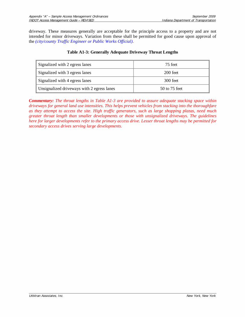
Appendix “A” – Sample Access Management Ordinances September 2009INDOT Access Management Guide – REVISED Indiana Department of Transportation
Urbitran Associates, Inc. New York, New York
driveway. These measures generally are acceptable for the principle access to a property and are notintended for minor driveways. Variation from these shall be permitted for good cause upon approval ofthe (city/county Traffic Engineer or Public Works Official).
Table A1-3: Generally Adequate Driveway Throat Lengths
Signalized with 2 egress lanes 75 feet
Signalized with 3 egress lanes 200 feet
Signalized with 4 egress lanes 300 feet
Unsignalized driveways with 2 egress lanes 50 to 75 feet
Commentary: The throat lengths in Table A1-3 are provided to assure adequate stacking space withindriveways for general land use intensities. This helps prevent vehicles from stacking into the thoroughfareas they attempt to access the site. High traffic generators, such as large shopping plazas, need muchgreater throat length than smaller developments or those with unsignalized driveways. The guidelineshere for larger developments refer to the primary access drive. Lesser throat lengths may be permitted forsecondary access drives serving large developments.

Appendix “A” – Sample Access Management Ordinances September 2009INDOT Access Management Guide – REVISED Indiana Department of Transportation
Urbitran Associates, Inc. New York, New York
Figure A1-7: Driveway Throat Length
Section 10: Requirements for Outparcels and Phased Development Plans
1. In the interest of promoting unified access and circulation systems, development sites under the sameownership or consolidated for the purposes of development and comprised of more than one building siteshall not be considered separate properties in relation to the access standards of this code. The number ofconnections permitted shall be the minimum number necessary to provide reasonable access to theseproperties, not the maximum available for that frontage. All necessary easements, agreements, andstipulations required under Section 7 shall be met. This shall also apply to phased development plans. Theowner and all lessees within the affected area are responsible for compliance with the requirements of thiscode and both shall be cited for any violation.
2. All access to the outparcel must be internalized using the shared circulation system of the principledevelopment or retail center. Access to outparcels shall be designed to avoid excessive movement acrossparking aisles and queuing across surrounding parking and driving aisles.
3. The number of outparcels shall not exceed one per ten acres of site area, with a minimum linealfrontage of 300 feet per outparcel or greater where access spacing standards for that roadway require.This frontage requirement may be waived where access is internalized using the shared circulation systemof the principle development or retail center. In such cases the right of direct access to the roadway shallbe dedicated to the (city/county) and recorded with the deed.

Appendix “A” – Sample Access Management Ordinances September 2009INDOT Access Management Guide – REVISED Indiana Department of Transportation
Urbitran Associates, Inc. New York, New York
Section 11: Emergency Access
In addition to minimum side, front, and rear yard setback and building spacing requirementsspecified in this code, all buildings and other development activities such as landscaping, shall bearranged on site so as to provide safe and convenient access for emergency vehicles.
Section 12: Transit Access
In commercial or office zoning districts where transit service is available or is planned to be availablewithin five years, provisions shall be made for adequate transit access, in the form of turn around loops orturnout bays. At a minimum, in the case of a loop or cul-de-sac, entrance curves shall have a radius of 35feet, and the internal circle shall have an inside radius of 30 feet and an outside radius of 52.5 feet. In thecase of turnout bays, the curve radius shall be 35 feet the distance from the roadside edge to the insideedge of the outside radius shall be 52.5 feet (see Figure A1-8).
Commentary: The bus turnaround standards in Figure A1-8 are provided for transit access along majorcommercial and office corridors to assure safe and convenient transit access. Bus turnarounds are usefulin circumstances where circulation via the internal street system of a development would be impracticalbased on cost, design constraints, or the need to maintain timely service. These bus turnarounds arebased upon the turning radius of a standard 40 foot bus.
Figure A1-8: Turnout Bay Turning Radii

Appendix “A” – Sample Access Management Ordinances September 2009INDOT Access Management Guide – REVISED Indiana Department of Transportation
Urbitran Associates, Inc. New York, New York
Section 13: Nonconforming Access Features
1. Permitted access connections in place as of (date of adoption) that do not conform with the standardsherein shall be designated as nonconforming features and shall be brought into compliance withapplicable standards under the following conditions:
a. When new access connection permits are requested;
b. Substantial enlargements or improvements;
c. Significant change in trip generation; or
d. As roadway improvements allow.
Commentary: Nonconforming access features may continue in the same manner after adoption of landdevelopment regulations--a process known as "grandfathering." This protects the substantial investmentof property owners and recognizes the expense of bringing those properties into conformance. Yet thenegative impacts of nonconforming properties may be substantial, depending upon the degree ofnonconformity. Nonconforming properties may pose safety hazards, increase traffic congestion, reduceproperty values, degrade the environment, and undermine community character. To address the publicinterest in these matters, land development regulations include conditions or circumstances wherenonconforming features must be brought into conformance. Opportunities to bring nonconformingfeatures into compliance typically occur after a change of ownership when the costs of requiredimprovements may be amortized in the business loan or mortgage, thereby minimizing financial hardship.It is essential that these standards be consistently and rigorously applied and enforced and that data andother information supporting these decisions be well documented, or the community could be open tolegal challenges regarding due process considerations.
2. If the principal activity on a property with nonconforming access features is discontinued for aconsecutive period of (180 or 365) days or discontinued for any period of time without a present intentionof resuming that activity, then that property must thereafter be brought into conformity with all applicableconnection spacing and design requirements, unless otherwise exempted by the permitting authority. Foruses that are vacant or discontinued upon the effective date of this code, the (180 or 365) day periodbegins on the effective date of this code.
Section 14: Corridor Access Management Overlay
1. The minimum lot frontage for all parcels with frontage on (name affected segments of thoroughfareshere or refer to a list) shall not be less than the minimum connection spacing standards of thatthoroughfare, except as otherwise provided in this Section. Flag lots shall not be permitted directaccess to the thoroughfare and interior parcels shall be required to obtain access via a public orprivate access road in accordance with the requirements of this Code.
Commentary: Overlay zones are an effective method for managing access along commercial corridors.The technique is used to add a special set of requirements to those of an existing zoning district ordistricts. Section 14(1) is for those major thoroughfares or portions of major thoroughfares under state orlocal jurisdiction that are not already extensively subdivided and are not planned for commercial orintensive development in the near future. This approach requires that any lot fronting designatedthoroughfares (usually those with an assigned access classification) have a minimum lot frontage thatmeets or exceeds the minimum connection spacing standard for those thoroughfares. Existing lots with

Appendix “A” – Sample Access Management Ordinances September 2009INDOT Access Management Guide – REVISED Indiana Department of Transportation
Urbitran Associates, Inc. New York, New York
less frontage would continue as nonconforming lots. Section 14(1) standards impose large minimum lotfrontage requirements to coordinate with desired connection spacing. Such requirements could dispersedevelopment and should not be applied in areas intended for intensive development. They are designedfor rural and semi-rural stretches of the state (or county) highway system.
2. The following requirements shall apply to segments of designated thoroughfares that are planned forcommercial or intensive development. All land in a parcel having a single tax code number, as of (date ofadoption), fronting on (define segment of affected thoroughfare or refer to a Table defining affectedsegments), shall be entitled one (1) driveway/connection per parcel as of right on said publicthoroughfare(s). When subsequently subdivided, either as metes and bounds parcels or as a recorded plat,parcels designated herein shall provide access to all newly created lots via the permitted accessconnection. This may be achieved through subdivision roads, joint and cross access, service drives, andother reasonable means of ingress and egress in accordance with the requirements of this Code. Thefollowing standards shall also apply:
a. Parcels with large frontages may be permitted additional driveways at the time of adoption ofthese requirements provided they are consistent with the applicable driveway spacing standards.
b. Existing parcels with frontage less than the minimum connection spacing for that corridor maynot be permitted a direct connection to the thoroughfare under this Section where the PlanningCommission determines alternative reasonable access is available to the site.
[Note: The Planning Commission could allow for a temporary driveway as provided in Section 7with the stipulation that joint and cross access be established as adjacent properties develop.]
c. Additional access connections may be allowed where the property owner demonstrates thatsafety and efficiency of travel on the thoroughfare will be improved by providing more than oneaccess to the site.
d. No parking or structure other than signs shall be permitted within (10- 50) feet of the roadwayright-of-way. The (10-50) foot buffer shall be landscaped with plants suitable to the soil and in amanner that provides adequate sight visibility for vehicles exiting the site. Property owners shallbe permitted to landscape the right-of-way, pursuant to an approved landscaping plan.
e. Permitted connections shall be identified on a map that shall be adopted by reference and thatportion of a corridor affected by these overlay requirements shall be delineated on the(city/county) zoning map with hatch marks.
Commentary: The regulations in Section 14(2) are intended for corridors that are planned forcommercial or intensive development and have not already been extensively subdivided into small lotfrontages. Such corridors may or may not be currently zoned for commercial or mixed use development,but may already be experiencing development pressure. This approach focuses, rather than disperses,development along corridors while maintaining regional mobility through access management. TheSection 14(2) overlay "freezes" allowable access to one connection by right per existing lot or parcel atthe time of adoption. Lots or parcels may be extensively subdivided, but all future lots must obtain accessvia the access connections permitted at the time of overlay adoption. This overlay approach allows forcontinued subdivision and development of land while stimulating joint access, local roads, and otheralternatives to direct thoroughfare access in the site design process (see Figure A1-9). These permittedconnections must be designated on a map and adopted with the overlay requirements. For flexibility,additional driveways may be permitted for large parcels that meet or exceed the minimum access spacingstandards for that thoroughfare, or where safety would be increased. Parcels with small frontages at the

Appendix “A” – Sample Access Management Ordinances September 2009INDOT Access Management Guide – REVISED Indiana Department of Transportation
Urbitran Associates, Inc. New York, New York
time of adoption are not permitted a driveway on the thoroughfare where this would create a safetyhazard or where alternative reasonable access is available. In such cases a temporary driveway could bepermitted under joint access requirements.
Figure A1-9: Corridor Access Management Overlay
Commentary: Local governments are also encouraged to apply design guidelines that enhancecommunity character, including standards for pedestrian access and landscaping. Section 14(2)(d) aboveis one potential standard for improving the visual quality of commercial corridors through landscapingand setbacks. The setback between the right-of-way and the parking area or structure should at aminimum be 10 feet. Some communities require as much as 50 feet. The appropriate standard will varyaccording to local preferences and existing right-of-way. If the existing right-of-way is very small, forexample, then the buffer should be increased and vice versa. Some communities are also promoting sideand rear parking, or shared parking areas, to reduce the appearance of asphalt from the street andprovide for a more pleasing site design.
Section 15: Reverse Frontage
1. Access to double frontage lots shall be required on the street with the lower functional classification.

Appendix “A” – Sample Access Management Ordinances September 2009INDOT Access Management Guide – REVISED Indiana Department of Transportation
Urbitran Associates, Inc. New York, New York
2. When a residential subdivision is proposed that would abut an arterial, it shall be designed to providethrough lots along the arterial with access from a frontage road or interior local road (see Figure A1-10).Access rights of these lots to the arterial shall be dedicated to the (city/county) and recorded with thedeed. A berm or buffer yard may be required at the rear of through lots to buffer residences from trafficon the arterial. The berm or buffer yard shall not be located within the public right-of-way.
Figure A1-10: Reverse Frontage
Commentary: If your community lacks any standards governing reverse frontage, it is essential thatsuch standards be adopted. These standards are currently applied by many communities and are highlyeffective in preventing safety hazards caused by direct residential access to high-speed roadways.
Section 16: Flag Lot Standards
1. Flag lots shall not be permitted when their effect would be to increase the number of propertiesrequiring direct and individual access connections to the State Primary Road System or other majorthoroughfares.
2. Flag lots may be permitted for residential development, when deemed necessary to achieve planningobjectives, such as reducing direct access to thoroughfares, providing internal platted lots with access to a

Appendix “A” – Sample Access Management Ordinances September 2009INDOT Access Management Guide – REVISED Indiana Department of Transportation
Urbitran Associates, Inc. New York, New York
residential street, or preserving natural or historic resources, under the following conditions:
a. Flag lot driveways shall be separated by at least twice the minimum frontage requirement ofthat zoning district.
b. The flag driveway shall have a minimum width of 20 feet and maximum width of 50 feet
c. In no instance shall flag lots constitute more than 10% of the total number of building sites in arecorded or unrecorded plat, or three lots or more, whichever is greater.
d. The lot area occupied by the flag driveway shall not be counted as part of the requiredminimum lot area of that zoning district.
e. No more than one flag lot shall be permitted per private right-of-way or access easement.

Appendix “A” – Sample Access Management Ordinances September 2009INDOT Access Management Guide – REVISED Indiana Department of Transportation
Urbitran Associates, Inc. New York, New York
Figure A1-11: Flag Lots and Alternative Access
Commentary: Local plat maps often reveal lots shaped like flags with long narrow access "poles". Flaglots are especially prevalent along lakes, rivers, cul-de-sacs, and rural highways. Although they can beuseful where natural features or land division patterns create access problems, they are subject to abuses.Flag lots proliferate in some areas where property owners use the technique to avoid plat review andfurther subdivide land. The result is a subdivision that lacks adequate access and creates long termproblems for the community and those who purchase the lots. Where the narrow frontages abut athoroughfare, they afford inadequate spacing between driveways and increase safety hazards fromvehicles turning on and off the high speed roadway. Because flag lots often violate driveway spacingstandards on the state highway system, they also create problems for the buyer who later attempts tobuild on the property and obtain a driveway permit. Under these standards existing flag lots would benonconforming and allowed to continue. In areas where flag lots proliferate on a state or countythoroughfare, property owners should be contacted and strongly encouraged to consolidate access withadjacent properties--especially in the case of abutting flag lots.
Section 17: Lot Width-to-Depth Ratios
1. To provide for proper site design and prevent the creation of irregularly shaped parcels, the depth ofany lot or parcel shall not exceed 3 times its width (or 4 times it width in rural areas).

Appendix “A” – Sample Access Management Ordinances September 2009INDOT Access Management Guide – REVISED Indiana Department of Transportation
Urbitran Associates, Inc. New York, New York
Commentary: Minimum lot frontage and maximum lot width-to-depth ratios prevent the creation of longand narrow or irregularly shaped lots that can lead to access and circulation problems. This standard isespecially useful in rural areas, to govern the dimensions of newly created lots and parcels. Note: Ruralareas may adopt a maximum width-to-depth ratio of 1:4, meaning that parcels with 100 feet of frontagemay not be deeper than 400 feet. Urban or suburban areas may use maximum ratios of 1:2.5 or 1:3.Width-to-depth ratios that are somewhat deeper may be permitted along arterials to provide for berms orbuffer yards in reverse frontage situations.
Section 18: Shared Access
1. Subdivisions with frontage on the state highway system shall be designed into shared access points toand from the highway. Normally a maximum of two accesses shall be allowed regardless of the numberof lots or businesses served (see Figure A1-12).
2. Subdivisions on a single residential access street ending in a cul-de-sac shall not exceed 25 lots ordwelling units, and the cul-de-sac shall have a minimum cartway radius of 30 feet.
Figure A1-12: Shared Access on Major Thoroughfares
Commentary: Subdivisions served by a single access street ending in a cul-de-sac may inhibit emergencyaccess and increase traffic congestion during peak hours by providing only one point of ingress andegress. Single access problems may also result in phased subdivisions where additional access isproposed for future phases. If future phases are not built, the remaining subdivision may have insufficient

Appendix “A” – Sample Access Management Ordinances September 2009INDOT Access Management Guide – REVISED Indiana Department of Transportation
Urbitran Associates, Inc. New York, New York
access. Although this is not a problem where only a few dwelling units are served, how many lots is toomany? Average daily trips for residential streets provide a baseline for access and cul-de-sac standards.Listokin and Walker (1989) recommend that when a subdivision on a single access residential accessstreet exceeds 25 lots (or 25 dwelling units), it should have at least two access points. A minimum turningradius that accommodates emergency vehicles should be required for cul-de-sacs.
The above provisions for shared access are intended to prevent a proliferation of driveways on the statehighway system--a common problem in some semi-rural and rural areas. Provisions for shared accessalso promote land development patterns that are more compatible with the rural character of thelandscape.
Section 19: Connectivity
1. The street system of a proposed subdivision shall be designed to coordinate with existing, proposed,and planned streets outside of the subdivision as provided in this Section.
2. Wherever a proposed development abuts unplatted land or a future development phase of the samedevelopment, street stubs shall be provided as deemed necessary by the (city/county) to provide access toabutting properties or to logically extend the street system into the surrounding area. All street stubs shallbe provided with temporary turn-around or cul-de-sacs unless specifically exempted by the Public WorksDirector, and the restoration and extension of the street shall be the responsibility of any future developerof the abutting land.
3. Collector streets shall intersect with collector or arterial streets at safe and convenient locations.
4. Sub-collector and local residential access streets shall connect with surrounding streets to permit theconvenient movement of traffic between residential neighborhoods or facilitate emergency access andevacuation, but such connections shall not be permitted where the effect would be to encourage the use ofsuch streets by substantial through traffic.
5. Pedestrian connections should be provided between adjacent properties in addition to roadwayconnections. These pedestrian connections should provide for safe pedestrian travel along roadways andacross parking areas to the buildings.
Commentary: Local governments must maintain a tenuous balance between enhancing accessibility andlimiting excessive through traffic in residential areas. These standards strive to address bothconsiderations. Properly used traffic calming measures are another means of minimizing through-trafficin residential areas.
Section 20: Minor Subdivisions
1. The (approving Department) may approve a Minor Subdivision that conforms to the followingstandards:
a. Each proposed lot must be buildable in conformance with the requirements of this Code and allother applicable regulations.
b. Each lot shall abut a public or private street for the required minimum lot frontage for thezoning district where the lots are located.

Appendix “A” – Sample Access Management Ordinances September 2009INDOT Access Management Guide – REVISED Indiana Department of Transportation
Urbitran Associates, Inc. New York, New York
c. If any lot abuts a street right-of-way that does not conform to the design specifications of thisCode, the owner may be required to dedicate one-half the right-of-way width necessary to meetminimum design requirements.
2. Further subdivision of the property shall be prohibited unless applicants submit a plat or developmentplan in accordance with requirements for major subdivisions in this Code.
Commentary: This standard prohibits property owners from incrementally subdividing land to avoidreview.
3. The (approving Department) shall consider a proposed Minor Subdivision upon the submittal of thefollowing materials:
a. An application form provided by the (city/county);
b. ( ) copies of the proposed Minor Subdivision plat;
[Note: The number of copies required should be based on number of entities that will review theplan under adopted procedures.]
c. A statement indicating whether water and/or sanitary sewer service is available to the property;and
d. Land descriptions and acreage or square footage of the original and proposed lots and a scaleddrawing showing the intended divisions shall be prepared by a professional land surveyorregistered in the Commonwealth of Kentucky. In the event a lot contains any principal oraccessory structures, a survey showing the structures on the lot shall accompany the application.
4. Review Procedure
a. The (approving official) shall transmit a copy of the proposed Minor Subdivision to theappropriate (departments or officials) for review and comment.
b. If the proposed Minor Subdivision meets the conditions of this section and otherwise complieswith all applicable laws and ordinances, the (approving official) shall approve the MinorSubdivision by signing the application form.
c. Upon approval of the Minor Subdivision, the (approving official) shall record the plat on theappropriate maps and documents, and shall, at the applicant's expense, record the plat in theofficial county records.
Commentary: These requirements for minor subdivisions are provided here to emphasize the importanceof adequate land division controls in access management. They provide for local review of divisions ofland or "lot splits" that would otherwise be exempted from subdivision review and platting requirements.A review process for lot splits prevents creation of lots that are not in conformance with landdevelopment regulations and thus could be rendered unbuildable. It further prevents creation of lots withinadequate or inappropriate access to a public road. This allows local governments to prevent accessproblems attributable to flag lots, through lots, and corner lots. This review process is streamlined andplatting requirements are less costly than those of a major subdivision, so as not to create a hardship forproperty owners engaged in only minor subdivision activity. Local governments are strongly advised notto provide exemptions from public review of land division activity based on lot size or number of lots,

Appendix “A” – Sample Access Management Ordinances September 2009INDOT Access Management Guide – REVISED Indiana Department of Transportation
Urbitran Associates, Inc. New York, New York
because this creates long term problems that can seriously undermine the local planning and regulatoryprogram.
Section 21: Private Roads
1. Private roads may be permitted in accordance with the requirements of this Section and the followinggeneral standards shall apply:
a. All (city/county) roads shall be constructed to public specifications and have an easement of aminimum of sixty-six feet in width, except as otherwise provided in Section 21 (2).
b. Private roads that by their existence invite the public in shall have all traffic control features, suchas striping or markers, in conformance with the Manual of Uniform Traffic Control Devices.
c. The minimum distance between private road outlets on a single side of a public road shall be 600feet, or less where provided by access classification and standards for state roads and localthoroughfares.
d. All properties served by the private road shall provide adequate access for emergency vehicles andshall conform to the approved local street numbering system.
e. All private roads shall be designated as such and will be required to have adequate signageindicating the road is a private road and not publicly maintained.
f. All private roads shall have a posted speed limit not to exceed twenty miles an hour.
g. All private roads shall have adequate provisions for drainage and stormwater runoff as provided inSection (refer to appropriate section of the local subdivision regulations).
h. A second access connection to a public road shall be required for private roads greater than 2000feet in length.
2. Private roads in rural and semi-rural areas may be permitted reductions in easement and roadway widthand pavement standards to provide for adequate access while retaining the rural character of the landscapeand design flexibility. At a minimum, the private road shall meet the (city/county) specifications forgravel roadway construction. Other standards shall apply in accordance with the following schedule:
a. A private road serving up to two lots shall have a minimum right-of-way easement of 30 feet and aroadbed of at least 12 feet.
b. A private road intended to serve no more than three to six lots shall have a minimum right-of-wayeasement of 30 feet and a roadbed of at least 16 feet.
c. A private road intended to serve no more than seven to twelve lots shall have a minimum right-of-way easement of 66 feet and a roadbed of at least 20 feet. Paving shall be required for all areas withgrades of greater than three (3%) percent. Such pavement shall be a minimum of 18 feet in width.
d. A private road intended to serve no more than 13 to 24 lots shall have a minimum right-of-wayeasement of 66 feet, a roadbed of at least 20 feet and shall be paved.
e. A private road intended to serve 25 or more lots or parcels shall provide at least two access
Appendix “A” – Sample Access Management Ordinances September 2009INDOT Access Management Guide – REVISED Indiana Department of Transportation
Urbitran Associates, Inc. New York, New York
connections to a public road and shall meet the minimum design requirements for public roads.
Commentary: This section provides a sliding scale approach, allowing gravel roads of about 12 feet to18 feet wide for 2-4 parcels and requiring higher design specifications for larger developments. Thestandards are intended to provide flexibility and to preserve the character of rural areas. Communitiesconsidering a sliding scale approach to private roads should also adopt a site plan review process aimedat encouraging creative site design and landscape preservation.
1. Applications for subdivision approval that contain private roads shall include a drainage plan and roadconstruction plan, prepared by a registered engineer. The (city/county) Public Works Official shall reviewprivate road plans for conformance with this Code.
2. Construction permits are required for connection to public roads. Application for road constructionshall be made concurrent with the creation of a lot that does not have frontage on a public road. A roadconstruction permit shall be issued after approval of the private road plan and the entire length of the roadshall be inspected during construction and upon completion. If found to be in conformance, a final usepermit shall be issued.
3. No building permit shall be issued for any lot served by a private road until the private road has beenconstructed and approved, so that all lots to be served by the private road have access to a public road.
4. A road maintenance agreement, prepared by the (city/county) attorney shall be recorded with the deedof each property to be served by a common private road. The agreement shall provide for:
a. A method to initiate and finance a private road and maintain that road in good condition;
b. A method of apportioning maintenance costs to current and future users;
c. A provision that the (city/county) may inspect, and if necessary, require that repairs be made tothe private road to ensure that safe access is maintained for emergency vehicles. If requiredrepairs are not made within six months of date of notice, the (city/county) may make thenecessary repairs and assess owners of parcels on the road for the cost of all improvements plusan administrative fee, not to exceed 25% of total costs;
d. A provision that the majority vote of all property owners on the road shall determine how theroad is maintained except in the case of emergency repairs as outlined above;
e. A statement that no public funds shall be used to construct repair or maintain the road;
f. A provision requiring mandatory upgrading of the roadway if additional parcels are added toreach the specified thresholds; and
g. A provision that property owners along that road are prohibited from restricting or in anymanner interfering with normal ingress and egress by any other owners or persons needing toaccess properties with frontage on that road.
5. No private road shall be incorporated into the public road system unless it is built to public roadspecifications of the (city/county). The property owners shall be responsible for bringing the road intoconformance.
6. All private roads shall have a sign and name meeting (city/county) standards and shall include the
Appendix “A” – Sample Access Management Ordinances September 2009INDOT Access Management Guide – REVISED Indiana Department of Transportation
Urbitran Associates, Inc. New York, New York
following notice: "Private Road" "Not maintained by the (city/county)".
7. An application fee will be established by the Director of Public Works to cover administrative,processing, and inspection costs.
8. All purchasers of property served by a private road shall, prior to final sale, be notified that the propertyreceives access from a private road that shall be maintained collectively by all property owners along thatroad; that the (city/county) shall not be held responsible for maintaining or improving the private road;and that a right-of way easement to provide the only access to that property has been recorded in the deedfor that property.
9. The United States postal service and the local school (board/district) is not required to use the privateroad for access to the parcels abutting the private road and may require that service be provided only atthe closest public access point.
Commentary: These private road standards were adapted from sample regulations prepared for theGrand Traverse Bay Region (Planning & Zoning Center, Inc., Lansing, Michigan, September 1992).Some communities prohibit private roads altogether or require all private roads serving more than onedwelling unit to be built to public specifications and paved. This is because of problems associated withprivate roads, such as pressure to adopt the private road into the public road system in the future. Yet ifproperly regulated, private roads can offer an effective means of access to small subdivisions in ruralareas. In the absence of private road regulations, common practice is the creation of multiple lots servedby a common lot, easement, or multiple easements as in the example of stacked flag lots. The easementthen becomes a private unpaved road serving several properties.
Unregulated private roads raise several problems. They may be inaccessible to emergency vehicles orlarge delivery trucks, placing public safety and private property at risk. Substandard roads deterioratequickly and without a maintenance agreement, the local government may be called upon to maintain it.Buyers may not be aware of the maintenance issues associated with the road until after purchasing theproperty. Narrow rights-of-way may impede placement of utilities, and private roads can exacerbateinefficient land development patterns. These problems can be avoided through private road regulationsthat address design, construction, joint maintenance agreements, signage, and review. Private roadsshould be permitted for residential uses only and standards should be tied to lot split (minor replat) orsubdivision regulations. Limitations should be placed upon the number of residences that may be servedby a single access to a public road.
As in other land development regulations, private road provisions must be made for grandfatheringexisting nonconforming situations. Some ordinances address the situation by providing a different set ofstandards for nonconforming private access or by providing for expansion of existing substandard privateroads or easements pursuant to the special use permit process.
Section 22: Regulatory Flexibility
1. The Planning Commission may permit departure from dimensional lot, yard, and bulk requirements ofthe zoning district where a subdivision or other development plan is proposed to encourage creativity insite design, protect natural resources, and advance the access objectives of this Code. Such regulatorymodifications under this section are not subject to variance approval by the Board of Adjustment.

Appendix “A” – Sample Access Management Ordinances September 2009INDOT Access Management Guide – REVISED Indiana Department of Transportation
Urbitran Associates, Inc. New York, New York
Section 23: Site Plan Review Procedures
1. Applicants shall submit a preliminary site plan for review by (name of department responsible forconducting review). At a minimum, the site plan shall show:
a. Location of access point(s) on both sides of the road where applicable;
b. Distances to neighboring constructed access points, median openings, traffic signals,intersections, and other transportation features on both sides of the property;
c. Number and direction of lanes to be constructed on the driveway plus striping plans;
d. All planned transportation features (such as auxiliary lanes, signals, etc.);
e. Trip generation data or appropriate traffic studies;
f. Parking and internal circulation plans;
g. Plat map showing property lines, right-of-way, and ownership of abutting properties; and
h. A detailed description of any requested variance and the reason the variance is requested.
2. Subdivision and site plan review shall address the following access considerations:
a. Is the road system designed to meet the projected traffic demand and does the road networkconsist of hierarchy of roads designed according to function?
b. Does the road network follow the natural topography and preserve natural features of the siteas much as possible? Have alignments been planned so grading requirements are minimized?
c. Is access properly placed in relation to sight distance, driveway spacing, and other relatedconsiderations, including opportunities for joint and cross access? Are entry roads clearly visiblefrom the major arterials?
d. Do units front on residential access streets rather than major roadways?
e. Is automobile movement within the site provided without having to use the peripheral roadnetwork?
f. Does the road system provide adequate access to buildings for residents, visitors, deliveries,emergency vehicles, and garbage collection?
g. Have the edges of the roadways been landscaped? If sidewalks are provided alongside the road,have they been set back sufficiently from the road, and has a landscaped planting strip betweenthe road and the sidewalk been provided?
h. Does the pedestrian path system link buildings with parking areas, entrances to thedevelopment, open space, and recreational and other community facilities?
Commentary: The subdivision and site plan review process provides local governments with the mosteffective opportunity for addressing access considerations and preventing access problems before they

Appendix “A” – Sample Access Management Ordinances September 2009INDOT Access Management Guide – REVISED Indiana Department of Transportation
Urbitran Associates, Inc. New York, New York
occur. This should be done as early as possible in the process. Developers will be far less amenable torevising the access plan later in the process or after the site plan or plat has been approved.
3. The (city/county) reserves the right to require traffic and safety analysis where safety is an issue orwhere significant problems already exist.
4. After 30 days from filing the application, applicants must be notified by the (permitting department) ifany additional information is needed to complete the application.
5. Upon review of the access application, the (permitting department) may approve the access application,approve with conditions, or deny the application. This must be done within 90 days of receiving thecomplete application.
6. Any application that involves access to the State Primary Road System shall be reviewed by theKentucky Transportation Cabinet for conformance with state access management standards. Where theapplicant requires access to the State Primary Road System, and a zoning change, or subdivision or siteplan review is also required, development review shall be coordinated with the Kentucky TransportationCabinet, as follows:
a. An access management/site plan review committee, that includes representatives of localKYTC District Office and the local government, shall simultaneously review the application. Thecommittee shall inform the developer what information will be required for access review.Information required of the applicant may vary depending upon the size and timing of thedevelopment, but shall at a minimum meet the requirements of this section.
b. Upon review of the application, the access management review committee shall advise the(local permitting department) whether to approve the access application, approve with conditions,or deny the application.
7. If the application is approved with conditions, the applicant shall resubmit the plan with the conditionalchanges made. The plan, with submitted changes, will be reviewed within 10 working days and approvedor rejected. Second applications may only be rejected if conditional changes are not made.
8. If the access permit is denied, the (city/county) shall provide an itemized letter detailing why theapplication has been rejected.
9. All applicants whose application is approved, or approved with conditions, have thirty days to acceptthe permit. Applicants whose permits are rejected or approved with conditions have 60 days to appeal.
Commentary: Effective coordination with INDOT, the local traffic engineer, transportation planner,and/or public works official is essential to ensure conformance with land division and accessrequirements. One method of improving coordination is to establish the building permit as the leadpermit during development review. In this way, property owners would be required to submit thenecessary permits or certificates of approval from regulatory agencies involved in development reviewbefore issuing a building permit. This should include a notice of intent to approve the proposed accessconnection from INDOT where the state highway system is involved to assure conformance with accessmanagement policies and regulations. The above review process would be incorporated into thecommunity's overall subdivision and site plan review process. A conceptual review, before submission ofthe preliminary site plan or plat, is highly recommended. Communities should also set fees and developthe necessary forms to carry out the provisions of this code.

Appendix “A” – Sample Access Management Ordinances September 2009INDOT Access Management Guide – REVISED Indiana Department of Transportation
Urbitran Associates, Inc. New York, New York
Section 24: Variance Standards
1. The granting of the variation shall be in harmony with the purpose and intent of these regulations andshall not be considered until every feasible option for meeting access standards is explored.
2. Applicants for a variance from these standards must provide proof of unique or special conditions thatmake strict application of the provisions impractical. This shall include proof that:
a. indirect or restricted access cannot be obtained;
b. no engineering or construction solutions can be applied to mitigate the condition; and
c. no alternative access is available from a street with a lower functional classification than theprimary roadway.
3. Under no circumstances shall a variance be granted, unless not granting the variance would deny allreasonable access, endanger public health, welfare or safety, or cause an exceptional and undue hardshipon the applicant. No variance shall be granted where such hardship is self-created.
Commentary: Each local government has its own process for handling appeals and variances. Thestandards above should be incorporated to this process. Providing for variances and other remedialmeasures is crucial to avoiding a takings claim by providing due process to the property owner andavoiding unreasonable hardship that may arise in relation to the regulatory framework. Federal case lawhas established that property owners should first exhaust available administrative remedies, includingappeals to the local board of adjustment, before the case may be heard in a court of law. If local appealprocedures exist and the property owner sues before first pursuing a variance or other remedial action,the case may be invalidated on this basis.

Appendix “A” – Sample Access Management Ordinances September 2009INDOT Access Management Guide – REVISED Indiana Department of Transportation
Urbitran Associates, Inc. New York, New York
Appendix A-2Sample Access Management Ordinances from the Michigan Access Management Guidebook
This appendix presents sample access management ordinances that were adapted for Indiana from theMichigan Access Management Guidebook to fit three common local situations:
Option 1: Best suited for a slowly growing rural community with one or two state highways ormajor county roads.
Option 2: Best suited for a rural community in the path of growth or a growing suburb withsignificant undeveloped land along major arterials.
Option 3: Best suited for an urban community with little undeveloped land and many retrofit orredevelopment opportunities.
Not all communities will neatly fit into one of the three situations described above. As a result, it may benecessary to pull elements from two or three of the options to fit the unique situation of an individualcommunity. The commentary in italics and [BRACKETED TEXT] shown in the sample ordinances inthis appendix is designed to help a community decide which parts of which sample ordinance to use andhow to adapt it. It is imperative that a community obtains qualified professional planning and legalassistance and coordinate closely with INDOT and local roadway engineering staff when adapting any ofthese sample regulations to fit a local situation. Because the administration of access managementregulations has some strong technical dimensions, it may also be necessary for a community to hire aqualified professional traffic engineer or transportation planner to assist them with this task, if it does nothave this expertise already.
Sample ordinance language to enable the collection of escrow fees for a professional review of a proposedsite plan is provided at the front of this Chapter under "Supplementary Ordinance Language". Thislanguage should be adopted along with one of the three access management regulatory options in thisChapter. This language ensures that communities, without professional planning and/or engineering staff,still have access to qualified professionals when reviewing site plans. Even if a community has suchstaff, a particular project may require unique skills or the staff may be overloaded with work and outsideassistance is needed. The costs of such professional reviews should be charged to the applicant. This canbe achieved by collecting and holding a fee from the applicant in escrow to pay for this cost. Any unusedfee must be returned to the applicant.
Also, in "Supplementary Ordinance Language" are definitions of terms used in the sample ordinances thatmay be unique. These definitions should also be added to the local ordinance. They will need to beadapted to fit each community. Note the term "access point" is very broad, but the term "driveway" isnarrow.
These three sample access management ordinance options are substantially adapted from the growthmanagement controls in Indiana and Florida, and model ordinances prepared for Michigan, New Yorkand Iowa communities. In Indiana, most access management has been implemented through the localdriveway permit process. Many of the broader access management polices implemented in Indianareflect the guidelines described in the INDOT Driveway Permit Manual. It is important that the samplelanguage that follows be properly adapted to fit the needs of your community.

Appendix “A” – Sample Access Management Ordinances September 2009INDOT Access Management Guide – REVISED Indiana Department of Transportation
Urbitran Associates, Inc. New York, New York
Site Plan Review Desirable
All of the following ordinance options (except Option 1a) assume that the community using them hasalready adopted zoning and subdivision regulations, so that approval processes are incorporated in thelocal zoning and subdivision approval processes. Site plan review is also desirable in conjunction withthe zoning approval process because site development plans may not be required for rezoning approval orfor the issuance of a permit for any structure verifying conformity with the local zoning ordinance). Itmay be desirable to reference the access management ordinance in existing zoning, subdivisionregulations and other land use controls (e.g., site plan review when established by a separate ordinance),particularly when a site plan review procedure does not currently exist
The following ordinance options also assume that decisions on local improvement permits (reviews ofuses allowed by right without any special review process or without site plan review) are made by theZoning Administrator and that decisions on site plans are made by the Planning Commission. If that isnot the case in your community, the sample language will need to be adapted to fit your situation.
For Additional Information
For additional information on access management regulations, or for other sample access managementordinances, consult the following publications:
• Model Land Development & Subdivision Regulations that Support Access Management, CUTR,1994.
• Best Practices in Arterial Management and Sample Access Management Ordinance, New YorkDepartment of Transportation, 1998.
• Access Management Handbook, Iowa DOT, 1999.
• National Access Management Manual, TRB, 2002.
• National Cooperative Highway Research Program (NCHRP), “Access Management Guidelines toActivity Centers” Report 348 and “Impacts of Access Management Techniques” Report 420.
• AASHTO “Green Book”, A Policy on Geometric Design of Highways and Streets.

Appendix “A” – Sample Access Management Ordinances September 2009INDOT Access Management Guide – REVISED Indiana Department of Transportation
Urbitran Associates, Inc. New York, New York
SUPPLEMENTARY ORDINANCE LANGUAGE
The following language is intended to accompany each of the sample Options in this Chapter. It isusually inserted in the "General Provisions" or "Supplementary Provisions" section of the Ordinance. Thefirst section covers escrow fees for professional reviews.
Fees in Escrow for Professional Reviews
Section ____: Fees in Escrow for Professional Reviews
Any application for rezoning, subdivision approval, location improvement permit, site plan approval, aSpecial Use Permit, Planned Unit Development, variance, or other use or activity requiring a permit underthis Ordinance above the following threshold, may also require the deposit of fees to be held in escrow inthe name of the applicant. An escrow fee shall be required by either the Zoning Administrator or thePlanning Commission for any project which requires a traffic impact study under Section _________, orwhich has more than _________ (e.g., twenty (20)) dwelling units, or more than _____________ (e.g.,fifteen thousand (15,000)) square feet of enclosed space, or which requires more than __________ (e.g.twenty (20)) parking spaces. [THRESHOLD COULD ALSO BE ANY PROPERTY ALONG THECORRIDOR IN THE OVERLAY DISTRICT, OR ANY USE REQUIRING SITE PLAN REVIEW.] Anescrow fee may be required to obtain a professional review of any other project which may, in the opinionof the Zoning Administrator or Planning Commission, create an identifiable and potentially negativeimpact on public roads, other infrastructure or services, or on adjacent properties, and because of which,professional input is desired before a decision to approve, deny or approve with conditions is made.
1) The escrow shall be used to pay professional review expenses of engineers, community planners, andany other professionals whose expertise the _______ (name of community) values to review theproposed application and/or site plan of an applicant. Professional review will result in a report to the__________ (name of community) indicating the extent of conformance or nonconformance with thisOrdinance and to identify any problems that may create a threat to the health, safety or generalwelfare of the public. Mitigation measures or alterations to a proposed design may be identifiedwhere they would serve to lessen or eliminate identified impacts. The applicant will receive a copyof any professional review hired by the _________ (name of community) and a copy of the statementof expenses for the professional services rendered, if requested.
2) No application for which an escrow fee is required will be processed until the escrow fee is depositedwith the _______ (name of community) Clerk. The amount of the escrow fee shall be establishedbased on an estimate of the cost of the services to be rendered by the professionals contacted by theZoning Administrator. The applicant is entitled to a refund of any unused escrow fees at the time apermit is either issued or denied in response to the applicant's request.
3) If actual professional review costs exceed the amount of an escrow, the applicant shall pay thebalance due prior to receipt of any land use or other permit issued by the _________ (name ofcommunity) in response to the applicant's request. Any unused fee collected in escrow shall bepromptly returned to the applicant once a final determination on an application has been made or theapplicant withdraws the request and expenses have not yet been incurred.
4) Disputes on the costs of professional reviews may be resolved by an arbitrator mutually satisfactoryto both parties.

Appendix “A” – Sample Access Management Ordinances September 2009INDOT Access Management Guide – REVISED Indiana Department of Transportation
Urbitran Associates, Inc. New York, New York
Definitions
The definitions that follow do not include those that are generally already included in local zoning andsubdivision ordinances. Accordingly, they must be compared with the definitions within local land usecontrol documents and any differences need to be reconciled. Not all of these definitions will be neededwith every adaptation of the sample ordinance. For example, very few of the definitions apply to Options1a or 1b. Please select only definitions for terms that are actually used. Note: Many of the defined termsthat follow are used in other definitions, but not in the sample ordinance language itself.
Access – A way or means of approach to provide vehicular or pedestrian entrance or exit to a propertyfrom an abutting property or a public roadway.
Access Connection – Any driveway, street, road, turnout or other means of providing for the movementof vehicles to or from the public road system or between abutting sites.
Access Management – The process of providing and managing reasonable access to land developmentwhile preserving the flow of traffic on the abutting roadway system in terms of safety, capacity, andspeed.
Access Management Plan – A plan establishing the preferred location and design of access for propertiesalong a roadway or the roadways in a community. It may be a freestanding document, or a part of acomprehensive plan, or a part of a corridor management plan.
Access Point – a) The connection of a driveway at the right-of-way line to a road, or b) A new road,driveway, shared access, or service drive.
Acceleration Lane – A speed-changing lane, including taper, for the purpose of enabling a vehicleentering the roadway to increase its speed to a rate at which it can safely merge with through traffic.
ADT – The annual average two-way daily traffic volume. It represents the total annual traffic for theyear, divided by 365. (Where annual data is not available, data from a shorter period may sometimes beused).
Alternative Means of Access – A shared driveway, frontage road, rear service drive, or connected parkinglot.
Arterial – See “Road Classification.”
AASHTO – Abbreviation of the American Association of State Highway and Transportation Officials,which conducts research and publishes many national road and non-motorized standards.
Boulevard – See “Divided Driveway”
Channelized or Channelizing Island – An area within the roadway or a driveway not for vehicularmovement; designed to control and direct specific movements of traffic to definite channels. The islandmay be defined by paint, raised bars, curbs, or other devices.
Classification of Roads – See “Road Classification.”
Collector – See “Road Classification.”

Appendix “A” – Sample Access Management Ordinances September 2009INDOT Access Management Guide – REVISED Indiana Department of Transportation
Urbitran Associates, Inc. New York, New York
Conflict – A traffic event that causes evasive action by a driver to avoid collision with another vehicle,bicycle, or pedestrian.
Conflict Point – An area where intersecting traffic either merges, diverges, or crosses.
Connected Parking Lot – Two or more parking lots that are connected by cross-access.
Corner Clearance – The distance from an intersection of a public or private road or street to the nearestaccess connection, measured from the closest edge of the driveway pavement to the closest edge of theroad pavement. [SOME COMMUNITIES MEASURE FROM THE CENTER OF THE DRIVEWAY.]
Corridor Overlay Zone – A zoning district that provides special requirements which apply to the propertyin addition to those of the underlying district regulations along portions of a public roadway.
Cross Access – A service road or driveway providing vehicular access between two or more contiguoussites so the driver need not enter the public road system.
Cross Street – The adjacent intersecting street or road.
Deceleration Lane – A speed-changing lane, including taper, for the purpose of enabling a vehicle toleave the through traffic lane at a speed equal to or slightly less than the speed of traffic in the throughlane and to decelerate to a stop or to execute a slow-speed turn.
Divided Driveway – A driveway with a raised median between ingress and egress lanes.
Divided Roadway – A roadway in which the opposite directions of travel are separated by a median,excluding a continuous two-way left-turn lane.
Driveway – Any entrance or exit used by vehicular traffic to or from land or buildings abutting a road.
Driveway Flare – A triangular pavement surface at the intersection of a driveway with a public street orroad that facilitates turning movements and is used to replicate the turning radius in areas with curb andgutter construction.
Driveway Offset – The distance between the inside edges of two driveways [OR COULD BEMEASURED FROM THE CENTERLINE OF EACH DRIVEWAY] on opposite sides of an undividedroadway.
Driveway Return Radius – A circular pavement transition at the intersection of a driveway with a street orroad that facilitates turning movements to and from the driveway.
Driveway, Shared – A driveway connecting two or more contiguous properties to the public road system.
Driveway Spacing – The distance between driveways as measured from the centerline of one driveway tothe centerline of the second driveway along the same side of the street or road. [SOME COMMUNITIESMEASURE FROM THE EDGE OF DRIVEWAY PAVEMENT TO EDGE OF THE PAVEMENT OFTHE SECOND DRIVEWAY.]
Driveway Width – Narrowest width of driveway measured perpendicular to the centerline of thedriveway.

Appendix “A” – Sample Access Management Ordinances September 2009INDOT Access Management Guide – REVISED Indiana Department of Transportation
Urbitran Associates, Inc. New York, New York
Egress – The exit of vehicular traffic from abutting properties to a street or road.
Frontage Road or Front Service Drive – A local street/road or private road typically located in front ofprincipal buildings, and parallel to an arterial, for service to abutting properties for the purpose ofcontrolling access to the arterial.
Functional Classification – A system used to group public roads into classes according to their purpose inmoving vehicles and providing access to abutting properties. See “Road Classification.”
Grade – The rate or percent of change in slope, either ascending or descending, from or along theroadway. It is to be measured along the centerline of the roadway or access connection.
Ingress – The entrance of vehicular traffic to abutting properties from a roadway.
Interchange – A facility that grade-separates intersecting roadways and provides directional ramps foraccess movements between the roadways. The structure, ramps, and right-of-way are considered part ofthe interchange.
Intersection – The location where two or more roadways cross at-grade without a bridge.
Intersection Sight Distance – The sight distance provided at intersections to allow the drivers of stoppedvehicles a sufficient view of the intersecting roadways to decide when to enter the intersecting roadway orto cross it. The time required is the sum of the perception/reaction time, plus the time to accelerate andcross or enter the major roadway traffic stream.
ITE – Abbreviation of the Institute of Transportation Engineers, which conducts research and publishesmany national road standards.
Lane – The portion of a roadway for the movement of a single line of vehicles that does not include thegutter or shoulder of the roadway.
Local Road or Street – See “Road Classification.”
Median – The portion of a divided roadway or divided entrance separating the traveled ways fromopposing traffic. Medians may be depressed, painted, or raised with a physical barrier or may belandscaped. A continuous two-way left-turn lane does not constitute a median.
Median Opening – A gap in a median provided for crossing and turning traffic.
Nonconforming Access – Features of the access system of a property that existed prior to the effectivedate of Article ___ and that do not conform with the requirements of this Ordinance; or in some cases,elements of approved access that are allowed by means of a temporary permit or on a conditional basis,until alternative access meeting the terms of this Ordinance becomes available.
Passing Sight Distance – The length of roadway ahead necessary for one vehicle to pass another beforemeeting an opposing vehicle that might appear after the passing maneuver began. [THIS TYPE OFSIGHT DISTANCE IS NOT AN ISSUE IN ACCESS MANAGEMENT.]
Peak Hour Trips (PHT) – A weighted-average vehicle trip generation rate during the hour of highestvolume of traffic entering and exiting the site in the morning (a.m.) or the afternoon (p.m.). [OR] The

Appendix “A” – Sample Access Management Ordinances September 2009INDOT Access Management Guide – REVISED Indiana Department of Transportation
Urbitran Associates, Inc. New York, New York
highest number of vehicles found to be passing over a segment of a roadway or lane during any 60consecutive minutes. [CHOOSE ONE.]
Principal Arterial – A major arterial. See “Road Classification.”
Reasonable Access – The minimum number of access connections, direct or indirect, necessary to providesafe access to and from a public road consistent with the purpose and intent of this Ordinance, with anyother applicable plans of the _______ (insert name of jurisdiction). Reasonable access does notnecessarily mean direct access.
Rear Service Drive – A local street/road or private road typically located behind principal buildings, andparallel to an arterial, for service to abutting properties for the purpose of controlling access to the arterial.
Right-of-Way – A general term denoting land, property, or interest therein, usually in a strip, acquired foror devoted to transportation purposes.
Road – A way for vehicular traffic, whether designated as a “street”, “highway”, “thoroughfare”,“parkway”, “through-way”, “avenue”, “boulevard”, “lane”, “cul-de-sac”, “place”, or otherwisedesignated, and includes the entire area within the right-of-way.
Roadway – That portion of a street, road, or highway improved, designed, or ordinarily used for vehiculartravel, exclusive of the curb-and-gutter or shoulder and side ditch. In the event a highway includes two ormore separate roadways, "roadway" refers to any such roadway separately, but not to all such roadwayscollectively. See also “Travel Way.”
Road Classification – Roadways are classified by the following categories and are indicated on Map ____by their functional classification. [NOTE: NOT EVERY COMMUNITY USES ALL SIXCLASSIFICATIONS (FOR EXAMPLE IT IS COMMON TO ONLY HAVE ONE TYPE OFCOLLECTOR), AND SOME COMMUNITIES USE A SLIGHTLY DIFFERENT FUNCTIONALCLASSIFICATION. BE SURE TO ADAPT THE CLASSIFICATIONS BELOW TO FIT THE LOCALSITUATION.]
1. Limited Access Highway – Major highways providing no direct property access that are designedprimarily for through traffic.
2. Major Arterial – Arterials are roadways of regional importance intended to serve moderate to highvolumes of traffic traveling relatively long distances. A major arterial is intended primarily to servethrough traffic where access is carefully controlled. Some major arterials are referred to as "principalarterials". [SOME COMMUNITIES REFER TO MAJOR ARTERIALS AS “MAJORTHOROUGHFARES.”]
3. Minor Arterial – A roadway that is similar in function to major arterials, but operates under lowertraffic volumes, over shorter distances, and provides a higher degree of property access than majorarterials. [SOME COMMUNITIES REFER TO THESE AS “MINOR THOROUGHFARES.”]
4. Major Collector – A roadway that provides for traffic movement between arterials and local streetsand carries moderate traffic volumes over moderate distances. Collectors may also provide directaccess to abutting properties.

Appendix “A” – Sample Access Management Ordinances September 2009INDOT Access Management Guide – REVISED Indiana Department of Transportation
Urbitran Associates, Inc. New York, New York
5. Minor Collector – A roadway similar in function to a major collector, but which carries lower trafficvolumes over shorter distances and provides a higher degree of property access than a majorcollector.
6. Local Street – A street or road intended to provide access to abutting properties, that tends toaccommodate lower traffic volumes and serves to provide mobility within that neighborhood.
Secondary Street or Side Street – A street or road with a lower functional classification than theintersecting street or road (e.g., a local street is a side or secondary street when intersecting with acollector or arterial).
Service Drive – See “Frontage Road” or “Rear Service Drive.”
Shared Driveway or Common Driveway – See “Driveway, Shared.”
Shoulder – The portion of a public road contiguous to the traveled way for the accommodation ofdisabled vehicles and for emergency use.
Sight Distance – The distance of unobstructed view for the driver of a vehicle, as measured along thenormal travel path of a roadway to a specified height above the roadway.
Standard – A definite rule or measure establishing a minimum level of quantity or quality that must becomplied with or satisfied in order to obtain development approval, such as (but not limited to) a height,setback, bulk, lot area, location or spacing requirement.
Stopping Sight Distance – The sum of the perception-reaction distance and the braking distance. Theavailable sight distance should be sufficiently long to enable a vehicle traveling at or near the designspeed to stop before reaching a stationary object in its path.
Street – See “Road.”
Taper – A triangular pavement surface that transitions the roadway pavement to accommodate anauxiliary lane.
Temporary Access – Provision of direct access to a road until that time when adjacent properties developin accordance with a joint access agreement, service road, or other shared access arrangement.
Thoroughfare – A public roadway, the principal use or function of which is to provide an arterial route forthrough traffic, with its secondary function the provision of access to abutting property, and that isclassified as a “limited access highway" or "major arterial” or “minor arterial” on the Street and HighwayClassification Map (see Map ____).
Throat Length – The distance parallel to the centerline of a driveway to the first on-site location at whicha driver can make a right-turn or a left-turn. On roadways with curb and gutter, the throat length shall bemeasured from the face of the curb. On roadways without a curb and gutter, the throat length shall bemeasured from the edge of the paved shoulder.
Throat Width – The edge-to-edge width of a driveway measured at the right-of-way line.
Travel Way – The portion of the roadway for the movement of vehicles, exclusive of shoulders andauxiliary lanes.

Appendix “A” – Sample Access Management Ordinances September 2009INDOT Access Management Guide – REVISED Indiana Department of Transportation
Urbitran Associates, Inc. New York, New York
TRB – Abbreviation of the Transportation Research Board, which conducts research and publishestransportation research, findings and policy.
Trip Generation – The estimated total number of vehicle trip ends produced by a specific land use oractivity. A trip end is the total number of trips entering or leaving a specific land use or site over adesignated period of time. Trip generation is estimated through the use of trip rates that are based uponthe type and intensity of development.
Undivided Roadway – A roadway having access on both sides of the direction of travel, includingroadways having center two-way left-turn lanes.

Appendix “A” – Sample Access Management Ordinances September 2009INDOT Access Management Guide – REVISED Indiana Department of Transportation
Urbitran Associates, Inc. New York, New York
ACCESS MANAGEMENT ORDINANCE OPTIONS
The commentary in italics and [BRACKETED TEXT] shown in the sample ordinances in this appendix isdesigned to help a community decide which parts of which sample ordinance to use and how to adapt it.
ORDINANCE OPTION 1 – BEST SUITED FOR A SLOWLY GROWING RURALCOMMUNITY WITH ONE OR TWO STATE HIGHWAYS
[TWO OPTIONS (OPTIONS 1A AND 1B) ARE PRESENTED TO MEET THE NEEDS OF A RURALCOMMUNITY WITH LITTLE LAND USE CHANGE, AND/OR LITTLE PROFESSIONAL STAFFOR CONSULTANT ASSISTANCE. OPTION 1A MERELY "LOCKS IN" EXISTING ACCESS SOTHAT AS LAND IS DIVIDED, ADDITIONAL ACCESS POINTS ARE NOT CREATED. THISAPPROACH LEAVES ALL DRIVEWAY PERMITS TO THE INDIANA DEPARTMENT OFTRANSPORTATION ON STATE HIGHWAYS AND TO THE BOARD OF COUNTYCOMMISSIONERS ON COUNTY ROADS. IT ALSO ESTABLISHES A SIMPLE COORDINATIONMECHANISM FOR REVIEW OF DEVELOPMENT PROPOSALS BEFORE THE APPROPRIATEROAD AUTHORITY MAKES A DRIVEWAY PERMIT DECISION. THE COMMUNITY MAY NOTEVEN HAVE A SITE PLAN REVIEW PROCESS IN THE ZONING ORDINANCE AND IT WOULDNOT BE NEEDED UNLESS THEY CHOOSE TO REGULATE SERVICE DRIVES.
OPTION 1B ALSO LEAVES ALL THE ACCESS MANAGEMENT DECISIONS TO THE INDIANADEPARTMENT OF TRANSPORTATION ON STATE HIGHWAYS AND TO THE BOARD OFCOUNTY COMMISSIONERS ON COUNTY ROADS, BUT INSTEAD OF "LOCKING IN ACCESS"IT TARGETS ONE OR TWO ARTERIALS (AS IDENTIFIED IN A "CORRIDOR OVERLAY ZONE")FOR COORDINATED REVIEW AND APPROVAL OF A PROPOSED SITE PLAN WITH THEDRIVEWAY PERMIT REQUIREMENTS OF THESE TWO ROAD AUTHORITIES. THISAPPROACH WOULD NEED SUBSTANTIAL MODIFICATION IN SECTION 0.3 TO ADAPT ITSUSE IN A CITY OR TOWN THAT CONTROLLED ALL THE STREETS WITHIN THECOMMUNITY. COORDINATION WOULD THEN BE BETWEEN THE CITY OR TOWN ROADAUTHORITY AND THE PLANNING COMMISSION.
OPTIONS 1A AND 1B CAN BE MOST EFFECTIVE IF THE COMMUNITY HAS DEVELOPMENTPLAN REVIEW, SITE PLAN REVIEW OR PLANNED UNIT DEVELOPMENT REVIEW, BECAUSETHE INDIANA STATE PLANNING ENABLING ACT (IC 36-7-4-1400 SERIES AND IC 36-7-4-1500SERIES) PERMITS A COMMUNITY TO IMPOSE CONDITIONS IN THE APPROVAL OF ADEVELOPMENT PLAN OR SITE PLAN OR PLANNED UNIT DEVELOPMENT BASED ON THEREQUIREMENTS OF OTHER COUNTY AND STATE AGENCIES. A COMMUNITY MAY ALSOIMPOSE “USE OR DEVELOPMENT COMMITMENTS” OR “LAND USE RESTRICTION” IF THEPROPERTY IS SUBJECT TO A CHANGE IN ZONING (IC 36-7-4-615). HOWEVER, EVENWITHOUT SITE PLAN REVIEW OR THE SUBJECT PROPERTY BEING SUBJECT TO A CHANGEIN ZONING, COORDINATION ALONE MAY PREVENT A COMMUNITY FROM APPROVING ASITE PLAN WITH ACCESS THAT DOES NOT MEET A ROAD AUTHORITY'S STANDARDS ANDVICE VERSA.
OPTIONS 1A AND 1B WILL WORK BEST WITH PROFESSIONAL PLANNING ASSISTANCE INREVIEW OF PROPOSED SITE PLANS FOR LARGE DEVELOPMENT PROPOSALS. IT ISIMPORTANT THAT THE COMPANION SAMPLE ORDINANCE LANGUAGE FOUND AT THEBEGINNING OF THIS APPENDIX UNDER “SUPPLEMENTARY ORDINANCE LANGUAGE”ALSO BE ADOPTED. THIS LANGUAGE PERMITS A COMMUNITY TO CHARGE ANAPPLICANT FOR THE COST OF A PROFESSIONAL REVIEW OF A SITE PLAN BYCOLLECTING AN ESCROW FEE ALONG WITH THE APPLICATION.

Appendix “A” – Sample Access Management Ordinances September 2009INDOT Access Management Guide – REVISED Indiana Department of Transportation
Urbitran Associates, Inc. New York, New York
OPTION 1A OR OPTION 1B COULD BE INSERTED AS A SEPARATE SECTION IN THEGENERAL PROVISIONS OR SUPPLEMENTARY PROVISIONS ARTICLE (OR CHAPTER) OFTHE ORDINANCE, OR CAN BE A SEPARATE ARTICLE (OR CHAPTER).
SECTION 0.3 IN OPTION 1A AND SECTION 1.3 IN OPTION 1B SET FORTH INFORMATION TOBE SUBMITTED BY AN APPLICANT AND A COORDINATION PROCESS FOR REVIEW OF ASITE PLAN. MOST LOCAL SITE PLAN REVIEW PROCEDURES ALREADY ADDRESS THESEISSUES; HOWEVER, THE COORDINATION FUNCTION MAY NOT BE AS CLEAR. BE SURE TOADAPT THIS LANGUAGE TO FIT THE LOCAL CIRCUMSTANCES. SECTION 0.4 IN OPTION 1AAND SECTION 1.4 IN OPTION 1B ADDRESS SERVICE DRIVES. SINCE THESE ARE USUALLYOUTSIDE THE RIGHT-OF-WAY OF A ROAD AUTHORITY, THERE MUST BE STANDARDS INTHE ORDINANCE IF THIS TECHNIQUE IS USED. STANDARDS SHOULD BE DERIVED FROMSECTION 2.3 IN OPTION 2 AND ADAPTED TO FIT THE LOCAL SITUATION.
_______________________________________
Note: The italic text in the following sample ordinances are directions (such as what to insert in a blankspace) or limited commentary and are NOT to be included as part of the adopted ordinance. Text inregular type is proposed ordinance language. Text in [BRACKETS AND LARGE CAPS] areexplanatory notes and are NOT to be included as part of the adopted ordinance.

Appendix “A” – Sample Access Management Ordinances September 2009INDOT Access Management Guide – REVISED Indiana Department of Transportation
Urbitran Associates, Inc. New York, New York
Option 1a - "Lock-In Access" Approach
[THIS APPROACH COULD BE:ADOPTED ALONE AND APPLIED TO A SINGLE CORRIDOR EXPECTED TO EXPERIENCEPRESSURE FOR LAND SPLITTING, ORIT COULD BE USED WITH OPTION 1B, ORIT COULD BE ADAPTED TO APPLY TO ALL ROADS IN THE COMMUNITY EXCEPT THOSESUBJECT TO THE CORRIDOR OVERLAY ZONE LANGUAGE IN OPTION 1B.
OPTION 1A SHOULD BE ADAPTED TO FIT THE LOCAL CIRCUMSTANCE. IN PARTICULAR, IFTHE COMMUNITY DOES NOT PERMIT PRIVATE ROADS, OR IF IT DOES NOT WISH TO ALLOWFRONT OR REAR SERVICE DRIVES, THE REFERENCES TO THEM WOULD NEED TO BEDELETED. ]
Section 0.1 – Intent
The provisions of this Article (or Chapter) are intended to promote safe and efficient travel withinthe________ (name of jurisdiction); minimize disruptive and potentially hazardous traffic conflicts;ensure safe access by emergency vehicles; protect the substantial public investment in the street systemby preserving capacity and avoiding the need for unnecessary and costly reconstruction which disruptsbusiness and traffic flow; separate traffic conflict areas by reducing the number of driveways; providesafe spacing standards between driveways, and between driveways and intersections; provide for sharedaccess between abutting properties; implement the _______ (name of jurisdiction) Comprehensive Planand the ________ Corridor ((insert name of Plan if there is one or use route name and/or number)(change “Corridor” to “Access”, if this is intended to be an access management plan) Management Planrecommendations; ensure reasonable access to properties, though not always by the most direct access;and to coordinate access decisions with the Indiana Department of Transportation and/or the _____Boardof County Commissioners, as applicable.
Section 0.2 – One Access Per Parcel
A. All land in a parcel or lot having a single tax code number, as of the effective date of the amendmentadding this provision to the Ordinance (hereafter referred to as "the parent parcel"), that shares a lot linefor less than _________ feet [AT LEAST 330 FEET, BETTER IS 660 FEET] with right-of-way on apublic road or highway [OR SPECIFICALLY DEFINE THE BEGINNING AND ENDING POINTS OFONE OR TWO CORRIDORS IF THE COMMUNITY DOES NOT WANT THIS PROVISION TOAPPLY TO ALL PUBLIC ROADS IN THE COMMUNIT]) shall be entitled to one (1) driveway or roadaccess per parcel from said public road or highway.
1. All subsequent land divisions of a parent parcel shall not increase the number of driveways orroad accesses beyond those entitled to the parent parcel on the effective date of this amendment.
2. Parcels subsequently divided from the parent parcel, either by metes and bounds descriptions,or as a plat under the applicable provisions of the Indiana Code regarding subdivision control (IC36-7-4-700 series, as amended) shall have access by a platted subdivision road, by another publicroad, by a private road that meets the requirements of Section ____, or by a service drive meetingthe requirements of Section 0.40.
B. Parent parcels with more than ______ feet [AT LEAST 330 FEET, BETTER IS 660 FEET] offrontage on a public road or highway shall also meet the requirements of A.1 and A.2 above, except thatwhether subsequently divided or not, they are entitled to not more than one driveway for each ________

Appendix “A” – Sample Access Management Ordinances September 2009INDOT Access Management Guide – REVISED Indiana Department of Transportation
Urbitran Associates, Inc. New York, New York
feet [AT LEAST 330 FEET, BETTER IS 660 FEET] of public road frontage thereafter, unless aregistered traffic engineer determines that topographic conditions on the site, curvature on the road, orsight distance limitations demonstrate a second driveway within a lesser distance is safer or the nature ofthe land use to be served requires a second driveway for safety. If the parcel is a corner lot and a seconddriveway is warranted, the second driveway shall have access from the abutting street unless that street isof a higher functional classification.
Section 0.3 – Application Review, Approval, and Coordination Process
A. Standards of Road Authorities Apply – All standards of the applicable road authority (specify eitherthe Indiana Department of Transportation or the ______ Board of County Commissioners, or both] shallbe met prior to approval of an access application under this Article.
B. Application, Review, and Approval Process – Applications for driveway or access approval shall bemade on a form prescribed by and available at _____________ (insert name of jurisdiction) and/or the________ Board of County Commissioners and Indiana Department of Transportation as applicable. [IFTHE COMMUNITY ALREADY HAS A SITE PLAN REVIEW PROCESS OR DRIVEWAY PERMITROCESS, THE FOLLOWING ITEMS CAN BE ADDED TO THE EXISTING LIST OF SUBMITTALREQUIREMENTS, IF THEY ARE NOT ALREADY INCLUDED.]
1. Applications shall be accompanied by clear, scaled drawings (minimum of 1’’=20’) intriplicate showing the following items:
a. Location and size of all structures proposed on the site.b. Size and arrangement of parking stalls on aisles.c. Proposed plan of routing vehicles entering and leaving the site (if passenger vehiclesare to be separated from delivery trucks indicate such on drawing).d. Driveway placement.e. Property lines.f. Right-of-way lines.g. Intersecting roads, streets and driveways within 300’ of either side of the property onboth sides of the street.h. Width of right-of-way.i. Width of road surface.j. Type of surface and dimensions of driveways.k. Proposed inside and outside turning radii.l. Show all existing and proposed landscaping, signs, and other structures or treatmentswithin and adjacent to the right-of-way.m. Traffic analysis and trip generation survey results, obtained from a licensed trafficengineer for all developments with over 100 directional vehicle trips per peak hour.n. Design dimensions and justification for any alternative or innovative access design.o. Dumpsters or other garbage containers.
2. Applications are strongly encouraged to rely on the following sources for access designs:
The National Access Management Manual, TRB, 2002;National Cooperative Highway Research Program (NCHRP), “Access ManagementGuidelines to Activity Centers” Report 348;“Impacts of Access Management Techniques” Report 420; andThe AASHTO “Green Book” (A Policy on Geometric Design of Highways and Streets)

Appendix “A” – Sample Access Management Ordinances September 2009INDOT Access Management Guide – REVISED Indiana Department of Transportation
Urbitran Associates, Inc. New York, New York
The following techniques are addressed in these guidebooks and are strongly encouraged to beused when designing access:
a. Not more than one driveway access per abutting roadb. Shared drivewaysc. Service drives: front, rear and perpendiculard. Parking lot connections with adjacent propertye. Other appropriate designs to limit access points on an arterial or collector
3. Applications shall be accompanied by an escrow fee for professional review per therequirements of Section _______. [BE SURE TO INCLUDE THIS SECTION IN THE ZONINGORDINANCE. SAMPLE LANGUAGE IS FOUND AT THE BEGINNING OF THISAPPENDIX UNDER "SUPPLEMENTARY REGULATIONS".]
C. Review and Approval Process – The following process shall be completed to obtain access approval:[THE FOLLOWING PROCESS COULD BE INCORPORATED INTO THE SITE PLAN REVIEWPROCESS OF THE ZONING ORDINANCE IF THERE IS ONE, INSTEAD OF BEING LISTEDSEPARATELY HERE.]
1. An Access Application meeting the requirements of Section 0.3.B.1 shall be submitted to theZoning Administrator and on the same day to the _____ Board of County Commissioners and/orthe Indiana Department of Transportation, as applicable.
2. The completed application must be received by the ____________ Zoning Administrator atleast ____ days (insert number, typically 14-30 days) prior to the Planning Commission meetingwhere the application will be reviewed.
3. The applicant, the Zoning Administrator and representatives of the _______ Board of CountyCommissioners, the Indiana Department of Transportation, and the Planning Commission maymeet prior to the Planning Commission meeting to review the application and proposed accessdesign. [SOME COMMUNITIES AND/OR ROAD AUTHORITIES MAY WANT THESEMEETINGS EVERY TIME, IF SO, CHANGE “MAY” TO “SHALL”.]
4. The Planning Commission shall review and recommend approval, or denial, or requestadditional information. They shall also forward the Access Application (and other relevantproject information) to the _______ Board of County Commissioners and/or Indiana Departmentof Transportation for their review as applicable.
5. The _______ Board of County Commissioners and/or the Indiana Department ofTransportation, as applicable, shall review the access application and conclusions of the PlanningCommission. One of three actions may result:
a. If the Planning Commission and the Board of County Commissioners, and/or theIndiana Department of Transportation, as applicable, approve the application assubmitted, the access application shall be approved.
b. If both the Planning Commission and the Board of County Commissioners, and/or theIndiana Department of Transportation, as applicable, deny the application, the applicationshall not be approved.

Appendix “A” – Sample Access Management Ordinances September 2009INDOT Access Management Guide – REVISED Indiana Department of Transportation
Urbitran Associates, Inc. New York, New York
c. If either the Planning Commission, the Board of County Commissioners, and/orIndiana Department of Transportation, as applicable, requests additional information,approval with conditions, or does not concur in approval or denial, there shall be a jointmeeting of the Zoning Administrator, a representative of the Planning Commission andstaff of the _______ County Board of Commissioners, and/or the Indiana Department ofTransportation, as applicable, and the applicants. The purpose of this meeting will be toreview the application to obtain concurrence between the Planning Commission and theapplicable road authorities regarding approval or denial and the terms and conditions ofany permit approval.
No application will be considered approved, nor will any permit be considered valid, unless allthe above-mentioned agencies have indicated approval, unless approval by any of the above-mentioned agencies would clearly violate adopted regulations of the agency. In this case, theapplication shall be denied by that agency and the requested driveway(s) shall not be constructed.Conditions may be imposed by the Planning Commission to ensure conformance with the termsof any driveway permit approved by a road authority.
6. The Zoning Administrator shall keep a record of each application that has been submitted,including the disposition of each one. This record shall be a public record.
7. Approval of an application remains valid for a period of one year from the date it wasauthorized. If authorized construction is not initiated by the end of one (1) year, the authorizationis automatically null and void. Any additional approvals that have been granted by the PlanningCommission or the Zoning Board of Appeals, such as Special Use Permits, or variances, alsoexpire at the end of one year.
8. An approval may be extended for a period not to exceed _______ [TYPICALLY 6 MONTHSTO ONE YEAR]. The extension must be requested in writing by the applicant before theexpiration of the initial approval. The Zoning Administrator may approve extension of anauthorization provided there are no deviations from the original approval present on the site, andthere are no violations of applicable ordinances and no development on abutting property hasoccurred with a driveway location that creates an unsafe condition. If there is any deviation orcause for question, the Zoning Administrator shall consult a representative of the _______ Boardof County Commissioners and/or the Indiana Department of Transportation, as applicable, forinput.
9. Re-issuance of an authorization that has expired requires a new Access Application form to befilled out and processed independently of any previous action.
10. The applicant shall assume all responsibility for all maintenance of such driveway approachesfrom the right-of-way line to the edge of the traveled roadway.
11. Where authorization has been granted for entrances to a parking facility, said facility shall notbe altered or the plan of operation changed until a revised Access Application has been submittedand approved as specified in this Section.
12. Application to construct or reconstruct any driveway entrance and approach to a site shall alsocover the reconstruction or closing of all nonconforming or unused entrances and approaches tothe same site at the expense of the property owner.
Appendix “A” – Sample Access Management Ordinances September 2009INDOT Access Management Guide – REVISED Indiana Department of Transportation
Urbitran Associates, Inc. New York, New York
13. When a building permit is sought for the reconstruction, rehabilitation, or expansion of anexisting site or a local improvement permit is sought for use or change of use for any land,buildings, or structures, all of the existing, as well as proposed driveway approaches and parkingfacilities shall comply, or be brought into compliance, with all design standards as set forth in thisOrdinance prior to the issuance of a location improvement permit, and pursuant to the proceduresof this section.
14. ___________ (insert name of jurisdiction) and the _______ Board of County Commissionersand/or the Indiana Department of Transportation, as applicable, may require a irrevocable letterof credit, performance bond [SOME JURISDICTIONS NO LONGER ACCEPTPERFORMANCE BONDS], or cash deposit in any sum not to exceed $5,000 for each suchapproach or entrance to ensure compliance with an approved application. Such financialinstrument shall terminate and any deposit shall be returned to the applicant when the terms of theapproval have been met or when the authorization is cancelled or terminated.
Section 0.4 – Service Drives
[ADAPT FROM SECTION 2.3 IN ORDINANCE OPTION 2 TO FIT LOCAL CIRCUMSTANCES, IFTHE COMMUNITY WISHES TO PERMIT SERVICE DRIVES.]
Option 1b - Rural Corridor Overlay Zone
[OPTION 1B IS INTENDED FOR USE IN A RURAL AREA WITHOUT PLANNING STAFF OR ASOPHISTICATED PLANNING COMMISSION. IT IS ESSENTIALLY THE SAME AS OPTION 1AWITHOUT THE "LOCK IN ACCESS" PROVISIONS AND IT TARGETS ONE OR TWOCORRIDORS. IF THE COMMUNITY IS IN THE PATH OF DEVELOPMENT, OR ANTICIPATESSIGNIFICANT DEVELOPMENT ALONG A PARTICULAR CORRIDOR IN THE NEXT FEWYEARS, IT WOULD BE BETTER TO ADOPT THE MORE ROBUST APPROACH PRESENTED INOPTION 2. HOWEVER, IF A COMMUNITY WAS UNPREPARED TO ADOPT ALL OF THEPROVISIONS IN OPTION 2, BUT WANTED MORE THAN THIS OPTION OFFERS, IT COULDADD ANOTHER SECTION 1.5 THAT WAS A "SLIMMED DOWN" VERSION OF THESTANDARDS IN SECTION 2.2 IN OPTION 2]
Section 1.1 – Intent
The provisions of this Article (or Chapter) are intended to promote safe and efficient travel withinthe________ (name of jurisdiction); minimize disruptive and potentially hazardous traffic conflicts;ensure safe access by emergency vehicles; protect the substantial public investment in the street systemby preserving capacity and avoiding the need for unnecessary and costly reconstruction which disruptsbusiness and traffic flow; separate traffic conflict areas by reducing the number of driveways; providesafe spacing standards between driveways, and between driveways and intersections; provide for sharedaccess between abutting properties; implement the _______ (name of jurisdiction) Comprehensive Planand the ________ Corridor (or Access) Management Plan (insert name of Plan if there is one)recommendations; ensure reasonable access to properties, though not always by the most direct access;and to coordinate access decisions with the Indiana Department of Transportation and/or the _____ Boardof County Commissioners, as applicable.

Appendix “A” – Sample Access Management Ordinances September 2009INDOT Access Management Guide – REVISED Indiana Department of Transportation
Urbitran Associates, Inc. New York, New York
Section 1.2 Identification of the Corridor Overlay Zone
The ______ (insert name of road here) corridor is defined as those properties that abut the highway right-of-way on either side of ________ (insert name of road here) in _____ (insert name of community here)between _____ (location A – usually an intersection) and ______ (location B – usually an intersection).[AS AN ALTERNATIVE, A MAP COULD BE ATTACHED AND SPECIFICALLY REFERRED TO.THIS IS A PREFERRED APPROACH IF PROPERTY DEEPER THAN THE ONE LOT ABUTTINGTHE ROAD IS PROPOSED FOR INCLUSION IN THE OVERLAY ZONE.] The following regulationsapply in addition to the applicable regulations of the specific districts beneath the overlay zone:
Section 1.3 – Application Review, Approval, and Coordination Process
[ADAPT FROM SECTION 0.3 IN OPTION 1A TO FIT LOCAL CIRCUMSTANCES.]
Section 1.4 – Standards for Service Drives
[ADAPT FROM SECTION 2.3 IN OPTION 2 TO FIT LOCAL CIRCUMSTANCES, IF THECOMMUNITY WISHES TO PERMIT SERVICE DRIVES.]
Section 1.5 – Driveway and Related Access Standards
[ADAPT FROM SECTION 2.2 IN OPTION 2 TO FIT LOCAL CIRCUMSTANCES, IF THECOMMUNITY WISHES TO REGULATE DRIVEWAY SPACING, LOCATION ANDCONSTRUCTION.]

Appendix “A” – Sample Access Management Ordinances September 2009INDOT Access Management Guide – REVISED Indiana Department of Transportation
Urbitran Associates, Inc. New York, New York
ORDINANCE OPTION 2 – BEST SUITED FOR A RURAL COMMUNITY IN THE PATH OFGROWTH OR A GROWING SUBURB WITH SIGNIFICANT UNDEVELOPED LAND ALONGMAJOR ARTERIALS
[OPTION 2 IS A COMPREHENSIVE ACCESS MANAGEMENT REGULATION. IT IS DIVIDEDINTO MAJOR TOPIC CATEGORIES WITH MANY SPECIFIC REGULATIONS WITHIN EACHCATEGORY. THE PERTINENT PROVISIONS FROM EVERY MAJOR TOPIC CATEGORYSHOULD BE REVIEWED AND ADAPTED TO FIT LOCAL CIRCUMSTANCES INCOOPERATION WITH APPROPRIATE BOARD OF COUNTY COMMISSIONERS AND INDOTSTAFF. ALTERNATIVE LANGUAGE IS OFFERED TO APPLY OPTION 2 TO ALL COLLECTORSAND ARTERIALS IN A COMMUNITY (NOT MERELY TO STATE HIGHWAYS AND KEY CITYOR COUNTY ROADS). BE SURE TO INSERT THE PROPER NAME OF THE COMMUNITY ANDTHE PERTINENT ROAD AUTHORITY NAMES IN THE PLACES INDICATED. MANY TASKSARE ASSIGNED TO THE ZONING ADMINISTRATOR. IF IT IS MORE APPROPRIATE TOASSIGN THESE TASKS TO SOMEONE ELSE, LIKE THE PLANNING DIRECTOR, BE SURE TOCHANGE THE TEXT ACCORDINGLY. OPTION 2 ASSUMES A COMPLETE LOCAL SITE PLANREVIEW PROCESS AND THAT REVIEWS ARE CAREFULLY COMPLETED IN COOPERATIONWITH THE APPROPRIATE ROAD AUTHORITY. A MEMORANDUM OF UNDERSTANDING(MOU) IS THE BEST WAY TO PROCEED. SOME COMMUNITIES MAY WANT TO ADD THEKEY PARTS OF THE MOU REVIEW PROCESS IN THE SITE PLAN REVIEW SECTION OF THEZONING ORDINANCE. IF SO, LANGUAGE IN OPTION 1A, SECTION 0.3 COULD BE USED ASA STARTING POINT. THE REST WOULD COME FROM THE MOU ITSELF. IF THISLANGUAGE IS PROPOSED FOR USE IN A CITY OR TOWN, WHICH CONTROLS ALL THESTREETS WITHIN THE COMMUNITY, THEN COORDINATION BETWEEN THE CITY ORTOWN ROAD AUTHORITY AND THE PLANNING COMMISSION (RATHER THAN WITHINDOT OR THE BOARD OF COUNTY COMMISSIONERS) WOULD BE THE FOCUS.]
CHAPTER ___ ACCESS MANAGEMENT REGULATIONS
Section 2.0 – Purpose, Intent and Application
A. The purpose of this Article (or Chapter) is to establish minimum regulations for access to property.Standards are established for new roads, driveways, shared access, parking lot cross access, and serviceroads. The standards of this Article (or Chapter) are intended to promote safe and efficient travel withinthe________ (name of jurisdiction); minimize disruptive and potentially hazardous traffic conflicts;ensure safe access by emergency vehicles; protect the substantial public investment in the street systemby preserving capacity and avoiding the need for unnecessary and costly reconstruction which disruptsbusiness and traffic flow; separate traffic conflict areas by reducing the number of driveways; providesafe spacing standards between driveways, and between driveways and intersections; provide for sharedaccess between abutting properties; implement the _______(name of jurisdiction) Comprehensive Planand the ________ Corridor (or Access) Management Plan (insert name of Plan) recommendations; ensurereasonable access to properties, though not always by the most direct access; and to coordinate accessdecisions with the Indiana Department of Transportation and/or the _____ Board of CountyCommissioners, as applicable.
B. The standards in this Article (or Chapter) are based on extensive traffic analysis of this corridor by the________ (name of jurisdiction), the _______ Board of County Commissioners, and the IndianaDepartment of Transportation (INDOT) as applicable. This analysis demonstrates that the combination ofroadway design, traffic speeds, traffic volumes, traffic crashes and other characteristics necessitate specialaccess standards. [INSERT THE TWO SENTENCES ABOVE IF TRUE, AND MODIFY TO FITSITUATION. OTHERWISE DELETE THEM.] The standards in this Article (or Chapter) apply to

Appendix “A” – Sample Access Management Ordinances September 2009INDOT Access Management Guide – REVISED Indiana Department of Transportation
Urbitran Associates, Inc. New York, New York
private and public land along road rights-of-way that are under the jurisdiction of the ________ (city ortown street department), the _______ Board of County Commissioners, or the Indiana Department ofTransportation (INDOT). [SELECT APPLICABLE ENTITIES ABOVE.] The requirements andstandards of this Article (or Chapter) shall be applied in addition to, and where permissible shallsupersede, the requirements of the Indiana Department of Transportation, ________ Board of CountyCommissioners, or other Articles (or Chapters) of this (zoning) Ordinance. [ADAPT PARAGRAPH TOFIT LOCAL CIRCUMSTANCES. IT IS ADVISABLE TO LIST SPECIFIC FINDINGS OF ANACCESS MANAGEMENT PLAN OR CORRIDOR MANAGEMENT PLAN HERE WHERE THEYSUPPORT THE PURPOSE OF THE REGULATIONS.]
C. The standards of this Article (or Chapter) shall be applied by the Zoning Administrator during platplan review and by the Planning Commission during site plan review, as is appropriate to the application.The Planning Commission shall make written findings of nonconformance, conformance, or conformanceif certain conditions are met, with the standards of this Article (or Chapter) prior to disapproving orapproving a site plan per the requirements of Section ______ (the site plan review section of this or otherOrdinance). The ________ (name of jurisdiction) shall coordinate its review of the access elements of aplot plan or site plan with the appropriate road authority prior to making a decision on an application (seeD. below). The approval of a plot plan or site plan does not negate the responsibility of an applicant tosubsequently secure driveway permits from the appropriate road authority, either the ________ (city ortown street department), the _________ Board of County Commissioners, or the Indiana Department ofTransportation (depending on the roadway). Any driveway permit obtained by an applicant prior toreview and approval of a plat or site plan that is required under this Ordinance will be ignored. [THISREVIEW PROCESS WILL BE EXPEDITED BY A FORMAL MEMORANDUM OFUNDERSTANDING BETWEEN THE COMMUNITY AND THE INDIANA DEPARTMENT OFTRANSPORTATION, AND/OR THE _______ BOARD OF COUNTY COMMISSIONERS.]
D. Neither the Zoning Administrator nor the Planning Commission shall take action on a request for anew road, driveway, shared access, or a service drive that connects to a public road without firstconsulting the ________ (name of city or town street department, when on a city or town street), the______ Board of County Commissioners (when on a county road), or the Indiana Department ofTransportation (when on a state highway). To ensure coordination, applicants are required to submit aplat, site plan, or a preliminary plat concurrently to both the ______ (name of jurisdiction), the ____Board of County Commissioners, and the Indiana Department of Transportation [BASED ON THEJURISDICTION RESPONSIBLE FOR REVIEW OF DEVELOPMENT ALONG SHARED PROPERTYLINES], as applicable. Complete applications shall be received at least ____ days (insert number ofdays—typically 14-30 days as established in the site plan review section of the Ordinance or by a staffprocedure manual) before the Planning Commission meeting at which action is to be taken. If the initialreview of the application by the Zoning Administrator reveals noncompliance with the standards of thisArticle (or Chapter), or if the proposed land use exceeds the traffic generation thresholds in Section______, then the Zoning Administrator shall require submittal of a Traffic Impact Study as describedbelow prior to consideration of the application by either the Zoning Administrator or the PlanningCommission.
1. At a minimum the Traffic Impact Study shall contain the following:
a. Analysis of existing traffic conditions and/or site restrictions using current data.
b. Projected trip generation at the subject site or along the subject service drive based onthe most recent edition of the Institute of Transportation Engineers Trip Generationmanual. The _____ (name of jurisdiction) may approve use of other trip generation data

Appendix “A” – Sample Access Management Ordinances September 2009INDOT Access Management Guide – REVISED Indiana Department of Transportation
Urbitran Associates, Inc. New York, New York
if based on recent studies of at least three (3) similar uses within similar locations inIndiana.
c. Illustrations of current and projected turning movements at access points. Includeidentification of the impact of the development and its proposed access on the operationof the abutting streets. Capacity analysis shall be completed based on the most recentversion of the Highway Capacity Manual published by Transportation Research Board,and shall be provided in an appendix to the Traffic Impact Study.
d. Description of the internal vehicular circulation and parking system for passengervehicles and delivery trucks, as well as the circulation system for pedestrians, bicyclesand transit users.
e. Justification of need, including statements describing how the additional access willmeet the intent of this Section, will be consistent with the _____ Corridor or AccessManagement Plan (insert name of Plan) and the _____ (name of jurisdiction)Comprehensive Plan, will not compromise public safety and will not reduce capacity ortraffic operations along the roadway.
f. Qualifications and documented experience of the author, describing experience inpreparing Traffic Impact Studies in Indiana. The preparer shall be either a registeredtraffic engineer (P.E.) or transportation planner with at least three (3) years of experiencepreparing Traffic Impact Studies in Indiana [OR OTHER QUALIFIED INDIVIDUAL—SEE LATER DISCUSSION ON EVALUATING TRAFFIC IMPACT STUDIES]. If theTraffic Impact Study involves geometric design, the study shall be prepared or supervisedby a registered engineer with a strong background in traffic engineering.
2. The ______ (name of jurisdiction) may utilize its own traffic consultant to review theapplicant's Traffic Impact Study, with the cost of the review being borne by the applicant perSection _____. [ADD SUPPLEMENTARY ORDINANCE LANGUAGE PRESENTED ATTHE START OF THE CHAPTER IN THE APPROPRIATE PLACE OF THE ORDINANCE.]
E. Failure by the applicant to begin construction of an approved road, driveway, shared access, servicedrive, or other access arrangement within twelve (12) months from the date of approval, shall void theapproval and a new application is required. [THIS SUBSECTION MAY ALREADY BEADEQUATELY COVERED ELSEWHERE IN THE ORDINANCE. IF SO, DELETE HERE.]
F. The Zoning Administrator (or city engineer or other authorized person) shall inspect the driveway asconstructed for conformance with the standards of this Ordinance and any approval granted under it, priorto issuing an occupancy permit. (Insert proper name of permit if different than "occupancy permit". Thissubsection "F" may already be adequately covered elsewhere in the Ordinance. Also, the community maywant to explore a formal agreement process to coordinate inspection with INDOT or the Board of CountyCommissioners so that dual inspections are avoided.)
Section 2.1 – Identification of Corridor Overlay Zone
The ______ (insert name of road here) corridor is defined as those properties that abut the highway right-of-way either side of ________ (insert name of road here) in _____ (insert name of community here)between _____ (location A – usually an intersection) and ______ (location B – usually an intersection).The following regulations supersede otherwise applicable regulations of the specific districts beneath theoverlay zone:

Appendix “A” – Sample Access Management Ordinances September 2009INDOT Access Management Guide – REVISED Indiana Department of Transportation
Urbitran Associates, Inc. New York, New York
[OR INSERT THE FOLLOWING ALTERNATIVE LANGUAGE WHICH WOULD MAKE THISARTICLE APPLY TO ALL STREETS AND ROADS IN THE COMMUNITY, NOT TO JUST A FEWMAJOR ARTERIALS. USE ONE OR THE OTHER, BUT NOT BOTH.]
Section 2.1 – Roadways Subject to Access Management Regulations
The access management regulations of this Article (or Chapter) apply to all property according to theroadway classification of the abutting public streets and roads within _______ (name of community) asdescribed below and as illustrated on Map ____. [THE COMMUNITY MAY OR MAY NOT ALSOWISH TO USE THE TEXT IN “A” AND “B” BELOW, WHICH FOLLOWS THE MAP FORGREATER CLARITY.]
A. Application of the access location and design standards of this Article (or Chapter) requiresidentification of the functional classification of the street on which access is requested and then applyingthe appropriate spacing requirements. The streets and roads of ________ (insert name of community) areclassified as follows and are as defined in Section _______:
1. Local Street or Road;2. Minor Collector;3. Major Collector;4. Minor Arterial;5. Major Arterial; and6. Limited Access Highway.
B. Major arterial, minor arterial, and collector streets are indicated on the Thoroughfare Map (Map ___).All unclassified public streets are local streets principally providing access to single-family residences.[ADD THIS NEXT SENTENCE ONLY IF LOCAL STREETS ARE NOT CLASSIFIED ON THE MAPOR USE THE FOLLOWING LANGUAGE.] The functional classification of any street in ______ (insertname of jurisdiction) not indicated as an arterial or collector on this Map shall be determined using thefunctional street classification defined by the AASHTO "Green Book", A Policy on Geometric Design ofHighways and Streets.)
Section 2.2 – Driveway and Related Access Standards
All lots hereafter created, and all structures hereafter created, altered, or moved on property with frontageon, or access to, a public road or street that is subject to regulation per Section 2.1, shall conform to thefollowing requirements:
A. General Standards [GREAT CARE SHOULD BE TAKEN TO CAREFULLY INTEGRATE THISSECTION WITH EXISTING ZONING DISTRICT REGULATIONS AND PROVISIONS IN THESCHEDULE OF REGULATIONS.]
1. Access Approval Required – No road, driveway, shared access, parking lot cross access,service road, or other access arrangement shall be established, reconstructed or removed withoutfirst meeting the requirements of this Section.
2. Frontage on a Public Road or Street – Any lot created after the effective date of this Ordinanceshall have frontage upon a public street right-of-way or private road or access easement recordedwith the County Recorder of Deeds that meets the requirements of this Article (or Chapter).

Appendix “A” – Sample Access Management Ordinances September 2009INDOT Access Management Guide – REVISED Indiana Department of Transportation
Urbitran Associates, Inc. New York, New York
Contiguous properties under one ownership or consolidated for unified development will beconsidered one parcel for purposes of this Article.
3. Minimum Lot Width – Except for existing lots of record, all lots fronting on a major arterial,arterial, or collector subject to this Article shall not be less than ______ feet in width (at least 300feet; 400 feet is better), unless served by shared access or a service drive that meets therequirements of Section 2.3, in which case minimum lot width may be reduced per therequirements of Section 2.6. [THIS CAN BE AN IMPORTANT INCENTIVE TO MOVE TOSHARED ACCESS.]
4. Structure Setback – No structure other than signs, as allowed in Section ___, telephone polesand other utility structures that are not buildings, transfer stations or substations, shall bepermitted within ______ feet of the roadway right-of-way. [THIS SHOULD BE DEEPENOUGH (USUALLY 75-100 FEET) TO PERMIT EXPANSION OF THE RIGHT-OF-WAYAT A FUTURE TIME WITHOUT PREVENTING EFFECTIVE USE OF THE STRUCTUREAT THAT TIME, IF CAPACITY IMPROVEMENTS LIKE THE ADDITION OF LANES OR AMEDIAN ON THE ROADWAY ARE LIKELY].
5. Parking Setback and Landscaped Area – No parking or display of vehicles, goods, or othermaterials for sale, shall be located within ____(often 50) feet of the roadway right-of-way. Thissetback shall be planted in grass and landscaped with small clusters of salt tolerant trees andshrubs suitable to the underlying soils unless another design is approved under the landscapeprovisions of Section _______. [THIS PROVISION IMPROVES THE AESTHETICAPPEARANCE ALONG A ROADWAY, AND IMPROVES THE CONTRAST BETWEEN AVEHICLE AND THE PAVEMENT, IMPROVING EASE OF VISIBILITY. IT ALSO SERVESAS A SNOW STORAGE ZONE. HOWEVER, THE ZONING ORDINANCE MAY VARYSETBACKS BY ZONING DISTRICT.]
6. Clear Vision – All access points shall maintain clear vision as illustrated in Figure ___. [SEEEXAMPLE IN FIGURE A2-1.]
7. Street Structures – No driveway shall interfere with municipal facilities such as street light ortraffic signal poles, signs, fire hydrants, cross walks, bus loading zones, utility poles, fire alarmsupports, drainage structures, or other necessary street structures. The Zoning Administrator isauthorized to order and effect the removal or reconstruction of any driveway that is constructed inconflict with street structures. The cost of reconstructing or relocating such driveways shall be atthe expense of the abutting property owner.

Appendix “A” – Sample Access Management Ordinances September 2009INDOT Access Management Guide – REVISED Indiana Department of Transportation
Urbitran Associates, Inc. New York, New York
Appendix “A” – Sample Access Management Ordinances September 2009INDOT Access Management Guide – REVISED Indiana Department of Transportation
Urbitran Associates, Inc. New York, New York
B. Access Location Standards
1. Access Point Approval - No access point shall connect to a public street or road without firstreceiving approval of the location and cross-section specifications from the ________ (name ofcity or town street department), when on a city or village street, ______ Board of CountyCommissioners (when on a county road) or the Indiana Department of Transportation (when on astate highway). No access point shall connect to a private road unless approved by the PlanningCommission and by the parties with an ownership interest in the private road. [INSERT THISSENTENCE ONLY IF PRIVATE ROADS ARE ALLOWED].
2. Factors on Location of Driveway Access – At a minimum, the following factors shall beconsidered prior to making a decision on the location of a driveway or other access point: [IFTHE COMMUNITY PREPARES A PROPERTY-SPECIFIC ACCESS MANAGEMENT PLAN,THESE FACTORS MAY BE ABLE TO BE REPLACED WITH A SPECIFIC REFERENCETO THE APPLICABLE PART OF THE ACCESS MANAGEMENT PLAN.]
a. The characteristics of the proposed land use;b. The existing traffic flow conditions and the future traffic demand anticipated by theproposed development on the adjacent street system;c. The location of the property;d. The size of the property;e. The orientation of structures on the site;f. The minimum number of driveways or other access points needed to accommodateanticipated traffic based on a traffic analysis, as determined by the community and roadagency. Such finding shall demonstrate traffic operations and safety along the publicstreet would be improved (or at least not negatively affected), and not merely that anotheraccess point is desired for convenience;g. The number and location of driveways on existing adjacent and opposite properties;h. The location and functional classification of abutting streets or roads and the carryingcapacity of nearby intersections;i. The proper geometric design of driveways;j. The spacing between opposite and adjacent driveways and from any nearbyintersection;k. The internal circulation between driveways and through parking areas;l. The size, location and configuration of parking areas relative to the driveways; andm. The speed of the adjacent roadway.
3. Access Point Location – Each access point location shall conform to access management plansor corridor improvement plans that have been adopted by the ________ (name of community), the_____ Board of County Commissioners, and/or the Indiana Department of Transportation.
4. Access Points within Right-of-Way – Driveways including the radii, but not including right-turn lanes, passing lanes and tapers, shall be located entirely within the right-of-way frontage,unless otherwise approved by the road agency and upon written certification from the adjacentland owner agreeing to such encroachment.
5. Backing-up from Parking or Loading Area onto a Public Street or Service Drive – Drivewayaccess to arterials shall not be permitted for any parking or loading areas that require backingmaneuvers in a public street or road right-of-way. Driveway access to collector streets, localstreets, or service drives for commercial, office, industrial, or multi-family developments shall not

Appendix “A” – Sample Access Management Ordinances September 2009INDOT Access Management Guide – REVISED Indiana Department of Transportation
Urbitran Associates, Inc. New York, New York
be permitted for parking or loading areas that require backing maneuvers in a public street right-of-way or onto a public or private service drive.
6. Relationship to Lot Line – No part of a driveway shall be located closer than ______ feet(typical range 4-15 feet) from a lot line unless it is a common or shared driveway as provided inSection 2.2 F. This separation is intended to help control stormwater runoff, permit snow storageon site, and provide adequate area for any necessary on-site landscaping.
7. Existing Driveways – Except for shared driveways, existing driveways that do not comply withthe requirements of this Article (or Chapter) shall be closed when an application for a change ofuse requiring a zoning permit or a site plan requiring approval under Section ____ is submittedand once approval of a new means of access under this Article (or Chapter) is granted. A closeddriveway shall be graded and landscaped to conform to adjacent land, and any curb cut shall befilled in with curb and gutter per the standards of the applicable road authority. See also Section2.5.
8. Intersection Sight Distance – Driveways shall be located so as not to interfere with safeintersection sight distance as determined by the appropriate road authority.
9. Adequate Corner Clearance – Driveways shall be located so as not to interfere with safe trafficoperations at an intersection as determined by Table A2-3 as long as that distance is beyond anyclear vision area owned by a road authority.
10. Traffic Signals – Access points on arterial and collector streets may be required to besignalized in order to provide safe and efficient traffic flow. Any signal shall meet the spacingrequirements of the applicable road authority. A development may be responsible for all or partof any right-of-way, design, hardware, and construction costs of a traffic signal if it is determinedthat the signal is warranted by the traffic generated from the development. The procedures forsignal installation and the percent of financial participation required of the development in theinstallation of the signal shall be in accordance with criteria of the road authority withjurisdiction. [MAKING THE “LAST GUY IN” PAY THE TOTAL COST OF A TRAFFICSIGNAL COULD BE UNREASONABLE IF HIS DEVELOPMENT ONLY GENERATED ASMALL PORTION OF THE TRAFFIC. FINANCIAL PARTICIPATION IN THE COST OF ASIGNAL NEEDS TO CONSIDER THE SHARE OF TRAFFIC GENERATED.]
C. Number of Driveways Permitted
1. Access for an individual parcel, lot, or building site (or for contiguous parcels, lots, or buildingsites under the same ownership) shall consist of either a single two-way driveway or a pairedsystem wherein one driveway is designed, and appropriately marked, to accommodate ingresstraffic and the other egress traffic.
2. One driveway shall be permitted for each single-family and two-family residential lot or parcel.
3. A temporary access permit may be issued for field entrances per Section 2.4, for cultivatedland, timber land, or undeveloped land, as well as for uses at which no one resides or works suchas cellular towers, water wells, pumping stations, utility transformers, billboards, and similaruses. Field-entrance and utility-structure driveways will be reviewed on a case-by-case basis.The review shall take into account the proximity of the adjacent driveways and intersectingstreets, as well as traffic volumes along the roadway.

Appendix “A” – Sample Access Management Ordinances September 2009INDOT Access Management Guide – REVISED Indiana Department of Transportation
Urbitran Associates, Inc. New York, New York
4. For a parcel, lot, or building site with frontage exceeding ____ feet (typically over 600 feet), orwhere a parcel, lot, or building site has frontage on at least two streets, an additional drivewaymay be allowed, provided that a Traffic Impact Study is submitted by the applicant showing thatconditions warrant an additional driveway and that all driveways meet the spacing requirements.
5. Certain developments generate enough traffic to warrant consideration of an additionaldriveway to reduce delays for exiting motorists. Where possible, these second access pointsshould be located on a side street or service drive, or shared with adjacent uses, or designed forright-turn-in, right-turn-out only movements, and shall meet the spacing requirements of thisordinance. In order to be considered for a second driveway on an arterial or collector street,combined approach volumes (entering and exiting) of a proposed development shall exceed 100directional trips during the peak hour of traffic and a Traffic Impact Study shall be performed.Uses where a second driveway could be considered are influenced by the trip generationcharacteristics of the uses and the volumes of the adjacent roadway. [SEE THE ITE TRIPGENERATION MANUAL FOR PEAK HOUR TRIP GENERATION COUNTS FORDRIVEWAYS BY TYPE OF LAND USE.] Table A2-1 lists land uses that may warrantconsideration of an additional driveway. [A COMMUNITY MAY NOT WISH TO PUBLISH ALIST AND INSTEAD LEAVE THE DETERMINATION UP TO TRAFFIC ENGINEERSFOLLOWING A TRAFFIC IMPACT STUDY. IF SO, DELETE THIS TABLE ANDRENUMBER THE REST OF THE TABLES ACCORDINGLY.] [NOTE: WHERE THEDEVELOPMENT HAS ACCESS TO A SIGNALIZED ARTERIAL OR COLLECTOR, THEAPPROACH VOLUME OF DRIVEWAY TRAFFIC SHOULD BE DOUBLE THAT OFUNSIGNALIZED LOCATIONS TO WARRANT CONSIDERATION OF A SECONDACCESS. SEE SECTION 2.2D.1.a.] [NOTE: IF RESIDENTIAL USES PREDOMINATE ONTHE SIDE STREET, THERE MAY BE OPPOSITION TO A COMMERCIAL DRIVEWAY.THE POTENTIAL NEGATIVE IMPACTS, AND HENCE OPPOSITION, MAY BEMITIGATED BY USE OF A DIRECTIONAL DRIVEWAY.]
Table A2-1Developments That May Warrant Consideration of an Additional Driveway
Multi-family developments with over 250 units;A grocery store of over 30,000 square feet gross floor area (GFA);A shopping center with over 40,000 square feet GFAA hotel or motel with over 400 rooms;Industrial developments with over 300,000 square feet GFA or 350 employees(although a secondary entrance for trucks should be allowed);Warehouses of over 750,000 square feet GFA or 350 employees;A mobile home park with over 300 units;General office building of 150,000 square feet GFA or 500 employees;Medical office building of 60,000 square feet GFA or 200 employees;Fast-food restaurant of over 6,000 square feet GFA;Sit-down restaurant of over 20,000 square feet GFA.
6. When alternatives to a single, two-way driveway are necessary to provide reasonable drivewayaccess to property fronting on an arterial street, and shared access or a service drive are not aviable option, the following progression of alternatives should be used:
a. One (1) standard, two-way driveway;b. Additional ingress/egress lanes on one (1) standard, two-way driveway;

Appendix “A” – Sample Access Management Ordinances September 2009INDOT Access Management Guide – REVISED Indiana Department of Transportation
Urbitran Associates, Inc. New York, New York
c. Two (2) one-way driveways;d. Additional ingress/egress lanes on two (2), one-way driveways;e. Additional driveway(s) on an abutting street with a lower functional classification;f. Additional driveway on an arterial street. Note: Restricted turns and roadwaymodifications will be considered in conjunction with alternative driveway designs.
D. Access Point Spacing Standards
1. Separation from Other Driveways
a. The minimum spacing between unsignalized driveways and other access points shallbe determined based upon posted speed limits along the parcel frontage unless theappropriate road authority approves less based on the land use and restricted turns in thedriveway design. The minimum spacings indicated below are measured from thecenterline of one driveway to the centerline of another driveway. [SOMECOMMUNITIES MEASURE FROM NEAREST EDGE OF PAVEMENT TONEAREST EDGE OF PAVEMENT.] For sites with insufficient road frontage to meetthe table below, the Planning Commission shall require one of the following:construction of the driveway along a side street, a shared driveway with an adjacentproperty, construction of a driveway along the property line farthest from the intersection,or a service drive as described in Section 2.3. The Planning Commission may granttemporary access approval (see Section 2.4) until such time that minimum spacingrequirements can be met, or alternative access meeting the requirements of this ordinanceis approved.
Table A2-2Minimum Access Spacing Between Adjacent Access Points
Posted Speed Limit (MPH) Minimum Access Spacing between AdjacentAccess Points (feet)
25 13030 18535 24540 30045 35050 455
Note: The values in Table A2-2 above are considered minimums, based on the distancesrequired to avoid conflicts between vehicles turning right or left from adjacent driveways.[THESE STANDARDS ARE SIGNIFICANTLY LESS THAN IN VARIOUSNATIONAL PUBLICATIONS. GREATER SPACING MAY BE ESPECIALLYAPPROPRIATE IN RURAL AREAS. LESSER SPACING MAY BE APPROPRIATEON NON-ARTERIAL ROADS THAT ARE ALREADY LARGELY DEVELOPED.]
b. In the case of expansion, alteration, or redesign of an existing development where itcan be demonstrated that pre-existing conditions prohibit adherence to the minimumdriveway spacing standards, the Planning Commission shall have the authority to modifythe driveway spacing requirements or grant temporary access approval until such timethat minimum spacing requirements can be met, or alternative access meeting therequirements of this ordinance is approved. Such modifications shall be the minimum

Appendix “A” – Sample Access Management Ordinances September 2009INDOT Access Management Guide – REVISED Indiana Department of Transportation
Urbitran Associates, Inc. New York, New York
amount necessary, but in no case shall driveway spacing of less than ___ feet [typically60-75 feet, depending on the common lot size in the area] be permitted by the PlanningCommission. [THIS SUBSECTION COULD BE REMOVED AND THECOMMUNITY COULD RELY ON SECTION 2.7 WAIVERS. IF THE WAIVERSSECTION IS NOT INCLUDED IN THE ORDINANCE, THAN THIS SECTIONNEEDS TO STAY HERE.]
2. Access Point Separation from Intersections – All single-family and two-family driveways shallbe separated from the nearest right-of-way of an intersecting street by at least ______ feet[USUALLY AT LEAST 50 FEET, MORE IF LOT SIZES ARE LARGE]. Driveways for allother land uses shall be separated from the nearest right-of-way of an intersecting street,according to Table A2-3 below:
Table A2-3Minimum Access Point Spacing from Street and Other Intersections*
Location of Access PointMinimum Spacing for a FullMovement Driveway or other
Access Point
Minimum Spacing for a DrivewayRestricting Left-turns (channelized forright-turn-in and right-turn-out only)
Along Arterial or from • Expressway Ramps • Railroad crossings
• Bridges• Median openings
300 feet [600 FEET ISBETTER] Contact INDOT for asite specific determination 100
feet 75 feet
300 feet [600 FEET IS BETTER] ContactINDOT for a site specific determination 100
feet 75 feet
Along Arterial or fromanother Intersecting Arterial 300 feet 125 feet
Along Arterial Intersectinga Collector or Local Street 200 feet 125 feet
Along a Collector 125 feet 75 feetAlong a Local Street or
Private Road 75 feet 50 feet
* Arterials and Collectors are as classified in the _______Comprehensive Plan (Thoroughfare Plan or on Map ____ in this Ordinance).
a. Access point spacing from intersections shall be measured from the centerline of thedriveway to the extended edge of the travel lane on the intersecting street, as shown inFigure A2-2 unless otherwise noted. [SOME COMMUNITIES CHOOSE TOMEASURE FROM THE EDGE OF THE DRIVEWAY, INSTEAD OF FROM THECENTER. SEPARATION DISTANCES NEED TO BE ADJUSTEDACCORDINGLY.]
b. The minimum distance between an access point and an intersecting street shall bebased on Figure A2-2 and the following: [ADAPT FIGURE A2-2 TO FIT TABLEDIMENSIONS DECIDED UPON IN A PARTICULAR UNIT OF LOCALGOVERNMENT.]

Appendix “A” – Sample Access Management Ordinances September 2009INDOT Access Management Guide – REVISED Indiana Department of Transportation
Urbitran Associates, Inc. New York, New York
[SOME COMMUNITIES MAY REQUIRE LESS RESTRICTIVE STANDARDSWHEN LOCATING A DRIVEWAY AWAY FROM A NON-SIGNALIZEDINTERSECTION THAN A SIGNALIZED ONE. IF SO, ADAPT THESESTANDARDS TO FIT THE LOCAL SITUATION. ALSO, THE APPROACH INDOTUSES IS MORE DIRECTLY TIED TO THE SPEED OF THE ARTERIAL, RATHERTHAN THE FUNCTIONAL CLASS OF THE ROAD. IT MAY BE A MORE USEFULAPPROACH IN SOME JURISDICTIONS.]
c. If the amount of lot frontage is not sufficient to meet the above criterion, the drivewayshall be constructed along the property line farthest from the intersection to encouragefuture shared use, and/or a frontage road or rear service drive shall be developed asdescribed in Section 2.3.
d. For parcels on which an alternative means of access (shared driveway, frontage road,service drive or connected parking lots) is not feasible due to parcel size or existingadjacent development, the Planning Commission may allow a non-channelized, fullmovement driveway provided that:
1. The driveway is spaced no closer to the intersection than the minimum spacingallowed for a right-turn-in, right-turn-out driveway; and

Appendix “A” – Sample Access Management Ordinances September 2009INDOT Access Management Guide – REVISED Indiana Department of Transportation
Urbitran Associates, Inc. New York, New York
2. A traffic study conducted by a registered traffic engineer shows a right-turn-in,right-turn-out driveway does not provide reasonable access or desired safety; and
3. A traffic study, conducted by a registered traffic engineer, provides substantialjustification that the driveway operation will not create safety problems at theadjacent intersection.
3. Access Alignment – In order to prevent left-turn conflicts, two-way driveways shall not beacross from an expressway ramp and shall be either:
a. Offset in accordance with the minimum spacing standards in Table A2-3, or
b. Perpendicular to the existing public street or an approved private road and shall line upwith existing or planned driveways on the opposite side of the road wherever facing lotsare not separated by a median, unless doing so in a particular case is substantiallydemonstrated by a registered traffic engineer to be unsafe.
E. Driveway Design and Construction Standards
1. Driveway or Throat Width
a. No single-family or two-family driveway shall have a width neither less than nine (9)feet nor more than sixteen (16) feet at the public road right-of-way. The drivewayopening, including flares, shall not be more than 1.5 times the width of the driveway atthe right-of-way line.
b. The typical commercial driveway design shall include one ingress lane and one egresslane with a combined maximum throat width of thirty (30) feet, measured from face toface of curb (see Figure A2-3a).
c. Where exiting traffic volumes are expected to exceed 100 directional trips per peakhour, or in areas where congestion along the arterial may create significant delays, asdetermined by the Planning Commission, two exit lanes shall be required. The totalwidth of such a driveway shall be between 37 and 39 feet, with one 15 foot wide ingresslane and two 11-12 foot wide egress lanes (See Figure A2-3b).
d. For access systems, which include a pair of one-way driveways, each driveway shallbe a minimum of sixteen (16) feet wide, measured perpendicularly (See Figure A2-3c).
e. As an alternative to (d) above, the driveway may be designed with a fully curbedmedian dividing the ingress and egress driveways, with a maximum median width of tenfeet. The radii forming the edges on the median shall be designed to accommodate thelargest vehicle that will normally use the driveway. Where median or boulevarddriveways are located across the street from each other, the left-turn egress lanes shall bealigned directly across from one another to minimize left-turn conflicts (see Figure A2-3d). Boulevard driveways should not be constructed at existing or future traffic signallocations unless there is a left-turn lane where the boulevard meets the road right-of-way.Ground or monument signs shall not be permitted in boulevards if they would blockmotorist vision or otherwise create an unsafe condition. The Planning Commission mayrequire landscaping on the portion of the boulevard outside the public right-of-way. Suchlandscaping shall use salt tolerant species.
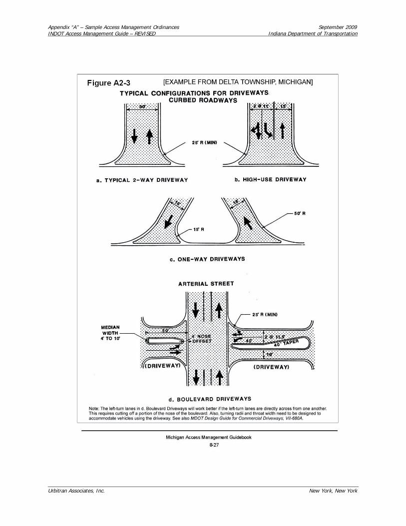
Appendix “A” – Sample Access Management Ordinances September 2009INDOT Access Management Guide – REVISED Indiana Department of Transportation
Urbitran Associates, Inc. New York, New York
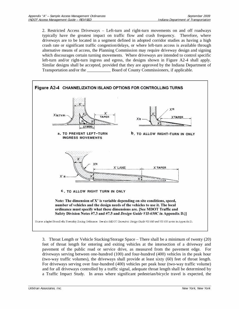
Appendix “A” – Sample Access Management Ordinances September 2009INDOT Access Management Guide – REVISED Indiana Department of Transportation
Urbitran Associates, Inc. New York, New York
2. Restricted Access Driveways – Left-turn and right-turn movements on and off roadwaystypically have the greatest impact on traffic flow and crash frequency. Therefore, wheredriveways are to be located in a segment defined in adopted corridor studies as having a highcrash rate or significant traffic congestion/delays, or where left-turn access is available throughalternative means of access, the Planning Commission may require driveway design and signingwhich discourages certain turning movements. Where driveways are intended to control specificleft-turn and/or right-turn ingress and egress, the designs shown in Figure A2-4 shall apply.Similar designs shall be accepted, provided that they are approved by the Indiana Department ofTransportation and/or the ___________ Board of County Commissioners, if applicable.
3. Throat Length or Vehicle Stacking/Storage Space – There shall be a minimum of twenty (20)feet of throat length for entering and exiting vehicles at the intersection of a driveway andpavement of the public road or service drive, as measured from the pavement edge. Fordriveways serving between one-hundred (100) and four-hundred (400) vehicles in the peak hour(two-way traffic volumes), the driveways shall provide at least sixty (60) feet of throat length.For driveways serving over four-hundred (400) vehicles per peak hour (two-way traffic volume)and for all driveways controlled by a traffic signal, adequate throat length shall be determined bya Traffic Impact Study. In areas where significant pedestrian/bicycle travel is expected, the

Appendix “A” – Sample Access Management Ordinances September 2009INDOT Access Management Guide – REVISED Indiana Department of Transportation
Urbitran Associates, Inc. New York, New York
ingress and egress lanes should be separated by a 4-10 feet wide median with pedestrian refugearea. In the absence of adequate traffic volume data, application of the commonly used values inTable A2-4 is appropriate.
Table A2-4Minimum Driveway Throat Length

Appendix “A” – Sample Access Management Ordinances September 2009INDOT Access Management Guide – REVISED Indiana Department of Transportation
Urbitran Associates, Inc. New York, New York
4. Construction Standards
a. Curb radii:
1. Driveways shall be designed with minimum 25-foot radii where primarilypassenger vehicle traffic is expected.
2. For sites where truck traffic is expected, the driveways shall be designed witha minimum 30 foot radii unless a traffic analysis by a qualified traffic engineerreveals another radii is more appropriate for the vehicles expected to use thedriveway.
b. Deceleration lanes and tapers:
1. Where it can be demonstrated that driveway volumes are expected to exceed100 peak hour directional trips per hour, a right-turn taper, deceleration laneand/or left-turn bypass lane may be required.
2. Where site frontage allows and a right-turn lane is warranted, a taper between50 and 225 feet may be required. See example in Figure A2-5a.

Appendix “A” – Sample Access Management Ordinances September 2009INDOT Access Management Guide – REVISED Indiana Department of Transportation
Urbitran Associates, Inc. New York, New York
3. Where the amount of frontage precludes the construction of a deceleration laneand taper combination entirely within the property lines of a parcel, a requestshall be made to the owner of the parcel to allow the installation of a right-turn

Appendix “A” – Sample Access Management Ordinances September 2009INDOT Access Management Guide – REVISED Indiana Department of Transportation
Urbitran Associates, Inc. New York, New York
bay and taper which extends beyond the property line. If permission cannot beobtained from the adjacent property owner for an extension onto that parcel, ataper of at least 75 feet shall be constructed as shown in Figure A2-5b.
4. A continuous right-turn lane, as shown in Figure A2-5c may be required wheredriveway spacing requirements restrict the use of consecutive turn bays andtapers, and a traffic engineer concludes it can be constructed without being usedas a through lane.
5. For driveways located along streets without an exclusive left-turn lane, abypass lane may be required. Such a lane shall be designed to the standards inthe Indiana Department of Transportation.
c. Acceleration lanes:
1. Generally, acceleration lanes are not permitted. However, where site frontageallows, and large semi-trucks and other slow moving vehicles routinely access anarterial, an acceleration lane may be required in consultation with the applicableroad authority.
2. The acceleration lane shall be designed by a traffic engineer to meet the needsof vehicles using it, topography, sight distance, and other relevant factors.
3. Driveways shall not be permitted within an acceleration lane.
d. Grades and drainage:
1. Driveways shall be constructed such that the grade for the 25 feet nearest thepavement edge or shoulder does not exceed 1.5% (one and one-half foot verticalrise in one-hundred feet of horizontal distance) wherever feasible. Where notfeasible, grades shall conform to Figure A2-6.

Appendix “A” – Sample Access Management Ordinances September 2009INDOT Access Management Guide – REVISED Indiana Department of Transportation
Urbitran Associates, Inc. New York, New York
2. Vertical curves with a minimum length of 15 feet shall be provided ondriveway approaches at a change in grade of 4% or more.
3. Driveways shall be constructed such that drainage from impervious areaslocated outside of the public right-of-way, which are determined to be in excessof existing drainage from these areas, shall not be discharged into the roadwaydrainage system absent the approval of the responsible agency. Storm drains orculverts, if required, shall be of a size adequate to carry the anticipated stormflow and be constructed and installed pursuant to the specifications of theresponsible road authority.
e. Surface and Curb Construction – Commercial and all other nonresidential drivewaysshall be constructed of a permanent asphalt or concrete material sufficient to provide thebearing capacity needed to carry the anticipated traffic loads as determined by theappropriate road authority unless the road authority approves use of another material.Where a driveway connects with a curbed road, it shall be paved and curbed from theedge of pavement to either the right-of-way line or point of curvature of the radiusreturns. All soil erosion and sedimentation requirements shall be met.
f. Directional Signs and Pavement Markings – In order to ensure smooth trafficcirculation on the site, direction signs and pavement markings shall be installed at thedriveway(s) in a clearly visible location as required by the ________ (name ofjurisdiction) as part of the site plan review process and approved by the IndianaDepartment of Transportation and ___________ Board of County Commissioners (asappropriate), and shall be maintained on a permanent basis by the property owner.Directional signs and pavement markings shall conform to the standards in the IndianaManual of Uniform Traffic Control Devices. [BE SURE TO COORDINATE THISWITH EXISTING SIGN STANDARDS IN THE ZONING ORDINANCE WHICHMAY REFER TO A DIFFERENT TYPE OF DIRECTIONAL SIGN.]
F. Shared Access – Shared access is strongly encouraged, and in some cases may be required. Whenrequired, one or more of the following options, and the standards of Section 2.3, apply:
1. Shared Driveways – Sharing or joint use of a driveway by two or more property owners shallbe encouraged. In cases where access is restricted by the spacing requirements of Section 2.2.D,“Access Point Spacing Standards”, a shared driveway may be the only access design allowed.The shared driveway shall be constructed along the midpoint between the two properties unless awritten easement is provided which allows traffic to travel across one parcel to access another,and/or access the public street.
2. Frontage Roads – In cases where a frontage road exists, is recommended either in the___________ (insert name of jurisdiction) Comprehensive Plan or in an adopted corridor study,and/or is proposed in an approved site plan for an adjoining lot or parcel, access shall be providedvia such frontage road, rather than by direct connection to the abutting arterial street.
3. Rear Service Drives – Rear service drives shall be encouraged, especially for locations where aconnection to a side street is available. In addition to access along the rear service drive, directconnection(s) to the arterial street may be allowed, provided that the driveways meet therequirements of Section 2.2.C, "Number of Driveways", and 2.2.D, "Access Point SpacingStandards."

Appendix “A” – Sample Access Management Ordinances September 2009INDOT Access Management Guide – REVISED Indiana Department of Transportation
Urbitran Associates, Inc. New York, New York
G. Parking Lot Connections – Where a proposed parking lot is adjacent to an existing parking lot of asimilar use, there shall be a vehicular connection between the two parking lots where physically feasible,as determined by the Planning Commission. For developments adjacent to vacant properties, the siteshall be designed to provide for a future connection. A written access easement signed by bothlandowners shall be presented as evidence of the parking lot connection prior to the issuance of any finalzoning approval. [SOME COMMUNITIES PROVIDE AN INCENTIVE FOR PARKING LOTCONNECTIONS BY ALLOWING A REDUCTION OF 5-10% OF REQUIRED PARKING SPACESFOR EACH USE IF THERE IS A PARKING LOT CONNECTION. SEE SECTION 2.6 FOR ANEXAMPLE.]
H. Access Easements – Shared driveways, cross access driveways, connected parking lots, and servicedrives shall be recorded as an access easement and shall constitute a covenant running with the land.Operating and maintenance agreements for these facilities should be recorded with the deed.
I. Medians and Median Openings:
1. The type, location and length of medians on public roads shall be determined by the entityhaving jurisdiction over such roads. This determination will be made in consultation with thePlanning Commission and will be based on existing and projected traffic conditions; the type,size, and extent of existing and projected development and traffic generated by development;traffic control needs; and other factors.
2. The minimum spacing between median openings shall be as shown in Table A2-5: [INSERTLOCAL NUMBERS IF BEING APPLIED ON A ROAD NOT UNDER INDOT CONTROL.]
Table A2-5Minimum Directional Median Opening Spacing
Location Directional crossover spacingUrban 660 feetRural 1,320 feet
3. Median openings intended to serve development must meet or exceed the minimum medianopening spacing standards and must also be justified by a Traffic Impact Analysis approved bythe entity having jurisdiction over such roads, in consultation with the Planning Commission (addas appropriate: or by the Planning Commission where driveways are proposed to connect to cityroads). The cost for preparation of the Traffic Impact Analysis and construction of the medianopening or openings, including installation and operation of signals and other improvements,where warranted, shall be borne by the applicant.
Section 2.3 – Service Drives and Other Shared Access Standards
A. The use of shared access, parking lot connections, and service drives—in conjunction with drivewayspacing—is intended to preserve traffic flow along major thoroughfares and minimize traffic conflicts,while retaining reasonable access to the property. Where noted above, or where the PlanningCommission determines that restricting new access points or reducing the number of existing accesspoints may have a beneficial impact on traffic operations and safety while preserving the property owner'sright to reasonable access, then access from a side street, a shared driveway, a parking lot connection, orservice drive connecting two or more properties or uses may be required instead of more directconnection to the arterial or collector street. However, where traffic safety would be improved, and the

Appendix “A” – Sample Access Management Ordinances September 2009INDOT Access Management Guide – REVISED Indiana Department of Transportation
Urbitran Associates, Inc. New York, New York
driveway spacing requirements of this ordinance can be met, then direct connection to the arterial orcollector street may be allowed in addition to a required service drive.
1. In particular, shared access, service drives, or at least a connection between abutting land usesmay be required in the following cases:
a. Where the driveway spacing standards of this section cannot be met.
b. Where recommended in the _____ Corridor Plan (or Access Management Plan) and/orother corridor or sub-area plans of the _____ (name of jurisdiction) Comprehensive Plan.
c. When the driveway could potentially interfere with traffic operations at an existing orplanned traffic signal location.
d. The site is along a collector or arterial with high traffic volumes, or along segmentsexperiencing congestion or a relatively high number of crashes.
e. The property frontage has limited sight distance.
f. The fire (or emergency services) department recommends a second means ofemergency access.
2. In areas where frontage roads or rear service drives are recommended, but adjacent propertieshave not yet developed, the site shall be designed to accommodate a future road/facility designedaccording to the standards of this Section. The Planning Commission may approve temporaryaccess points where a continuous service drive is not yet available and a irrevocable letter ofcredit, performance bond [NOT PERMITTED IN SOME JURISDICTIONS], or escrow isaccepted to assure elimination of temporary access when the service road is constructed. (SeeSection 2.4 Temporary Access Permits).
B. Notwithstanding the requirements of the _________ (community name and Ordinance Number)Subdivision Ordinance, the standards for all service drives shall be as follows:
1. Site Plan Review – The Planning Commission shall review and approve all service drives toensure safe and adequate continuity of the service drive between contiguous parcels as part of thesite plan review process in Section ______.
2. Front and Rear Service Drives – A front or rear service drive may be established on propertythat abuts only one public road. The design of a service road shall conform with national designguidelines such as those identified in the National Access Management Manual by TRB, theAASHTO “Green Book”, and National Cooperative Highway Research Program (NCHRP),“Access Management Guidelines to Activity Centers” Report 348 and “Impacts of AccessManagement Techniques” Report 420.
3. Location – Service roads shall generally be parallel to the front property line and may belocated either in front of, or behind, principal buildings and may be placed in required yards. Inconsidering the most appropriate alignment for a service road, the Planning Commission shallconsider the setbacks of existing and/or proposed buildings and anticipated traffic flow for thesite.

Appendix “A” – Sample Access Management Ordinances September 2009INDOT Access Management Guide – REVISED Indiana Department of Transportation
Urbitran Associates, Inc. New York, New York
4. Width and Construction Materials – A service drive shall be within an access easementpermitting traffic circulation between properties. The easement shall be recorded with the CountyRegister of Deeds. This easement shall be at least forty (40) feet wide. A service drive shall havea minimum pavement width of ____ [TYPICALLY 26-36)]feet, measured face to face of curbwith an approach width of _______ feet [TYPICALLY 36-39 FEET] at intersections. Theservice drive shall be constructed of a paved surface material that is resistant to erosion and shallmeet ________ (city or town, Board of County Commissioners, or INDOT – depending on whatroad the service drive parallels) standards for base and thickness of asphalt or concrete, unlessthe community has more restrictive standards.
5. Snow Storage and Landscaping Area – A minimum of fifteen (15) feet of snowstorage/landscaping area shall be reserved along both sides of the service drive. Frontage roadsshall have a minimum setback of 30 feet from the right-of-way, with a minimum of 60 feet ofstorage at the intersection for entering and exiting vehicles as measured from the pavement edge(See Figure A2-7a).

Appendix “A” – Sample Access Management Ordinances September 2009INDOT Access Management Guide – REVISED Indiana Department of Transportation
Urbitran Associates, Inc. New York, New York
6. Distance from Intersection on Service Drives – Frontage road and service drive intersections atthe collector or arterial street shall be designed according to the same minimum standards asdescribed for driveways in Section 2.2.D.2.

Appendix “A” – Sample Access Management Ordinances September 2009INDOT Access Management Guide – REVISED Indiana Department of Transportation
Urbitran Associates, Inc. New York, New York
7. Driveway Entrance – The Planning Commission shall approve the location of all accesses tothe service drive, based on the driveway spacing standards of this Article (or Chapter). Access tothe service drive shall be located so that there is no undue interference with the free movement ofservice drive and emergency vehicle traffic, where there is safe sight distance, and where there isa safe driveway grade as established by the applicable road authority.
8. Driveway Radii – All driveway radii shall be concrete curbs and conform to the requirementsof Section 2.2.E.4.
9. Acceleration Lanes and Tapers – The design of the driveway, acceleration, deceleration ortaper shall conform to the requirements of Section 2.2.E.4.
10. Elevation – The elevation of a service drive shall be uniform or gently sloping betweenadjacent properties.
11. Service Drive Maintenance – No service drive shall be established on existing public right-of-way. The service drive shall be a public street (if dedicated to and accepted by the public), or aprivate road maintained by the adjoining property owners it serves who shall enter into a formalagreement for the joint maintenance of the service drive. The agreement shall also specify who isresponsible for enforcing speed limits, parking and related vehicular activity on the service drive.This agreement shall be approved by the ______ (municipality) attorney and recorded with thedeed for each property it serves by the County Recorder of Deeds. If the service drive is a privateroad, the local government shall reserve the right to make repairs or improvements to the servicedrive and charge back the costs directly or by special assessment to the benefiting landowners ifthey fail to properly maintain a service drive.
12. Landscaping – Landscaping along the service drive shall conform to the requirements ofSection ____ (reference applicable landscaping standards). Installation and maintenance oflandscaping shall be the responsibility of the developer or a property owners association.
13. Parking Areas – All separate parking areas (i.e. those that do not use joint parking crossaccess) shall have no more than one (1) access point or driveway to the service drive.
14. Parking – The service road is intended to be used exclusively for circulation, not as a parking,loading, or unloading aisle. Parking shall be prohibited along two-way frontage roads and servicedrives that are constructed at the minimum width (see B.4. above). One-way roads or two-wayroads designed with additional width for parallel parking may be allowed if it can bedemonstrated through traffic studies that on-street parking will not significantly affect thecapacity, safety, or operation of the frontage road or service drive. Perpendicular or angleparking along either side of a designated frontage road or service drive is prohibited. ThePlanning Commission may require the posting of "no parking" signs along the service road. As acondition to site plan approval, the Planning Commission may permit temporary parking in theeasement area where a continuous service road is not yet available, provided that the layoutallows removal of the parking in the future to allow extension of the service road. Temporaryparking spaces permitted within the service drive shall be in excess of the minimum requiredunder Article____, Parking and Loading Standards.
15. Directional Signs and Pavement Markings – Pavement markings may be required to helppromote safety and efficient circulation. The property owner shall be required to maintain all

Appendix “A” – Sample Access Management Ordinances September 2009INDOT Access Management Guide – REVISED Indiana Department of Transportation
Urbitran Associates, Inc. New York, New York
pavement markings. All directional signs and pavement markings along the service drive shallconform to the current Indiana Manual of Uniform Traffic Control Devices.
16. Assumed Width of Pre-existing Service Drives – Where a service drive in existence prior tothe effective date of this provision has no recorded width, the width will be considered to be_______ [TYPICALLY 40-66] feet for the purposes of establishing setbacks and measured anequal distance from the midpoint of the road surface.
17. Pedestrian and Bicycle Access – Separate, safe access for pedestrians and bicycles shall beprovided on a sidewalk or paved path that generally parallels the service drive unless alternateand comparable facilities are approved by the Planning Commission.
18. Number of Lots or Dwellings Served – No more than twenty-five (25) lots or dwelling unitsmay gain access from a service drive to a single public street.
20. Service Drive Signs – All new public and private service drives shall have a designated nameon a sign meeting the standards on file in the office of the Zoning Administrator.
21. In the case of expansion, alteration or redesign of existing development where it can bedemonstrated that pre-existing conditions prohibit installation of a frontage road or service drivein accordance with the aforementioned standards, the Planning Commission shall have theauthority to allow and/or require alternative cross access between adjacent parking areas throughthe interconnection of main circulation aisles. Under these conditions, the aisles serving theparking stalls shall be aligned perpendicularly to the access aisle, as shown in Figure A2-7c, withislands, curbing and/or signage to further delineate the edges of the route to be used by throughtraffic.
Section 2.4 – Temporary Access Permits
A. A temporary access permit may be conditionally issued to a property included in an adopted corridoror access management plan that programs road improvements and installation of service drives and shareddriveways that would eliminate the need for the temporary driveway.
B. Conditions may be included in the temporary access permit including but not limited to, a limitation ondevelopment intensity on the site until adjoining parcels develop which can provide a shared driveway,shared access via a service drive, and/or cross parking lot connection consistent with the requirements ofSection 2.3.
C. A temporary access permit shall expire when the use of the site for which the temporary access permitwas granted has ceased for twelve (12) months or more, or the use of the site or the driveway has changedsuch that the use of the driveway has increased from its initial use level at least __________ percent.
D. A site plan for property that cannot meet the access requirements of Section 2.3, nor the waiverstandards in Section 2.7, and has no alternative means of reasonable access to the public road system maybe issued a temporary access permit. When adjoining parcels develop which can provide a shareddriveway, shared access via a service drive or a cross parking lot connection, the temporary access permitshall be rescinded and an application for an access permit consistent with the requirements of Section 2.3shall be required.

Appendix “A” – Sample Access Management Ordinances September 2009INDOT Access Management Guide – REVISED Indiana Department of Transportation
Urbitran Associates, Inc. New York, New York
Section 2.5 – Nonconforming Driveways
A. Driveways that do not conform to the regulations in this Article (or Chapter), and were constructedbefore the effective date of this Article (or Chapter), shall be considered legal nonconforming driveways.Existing driveways granted a temporary access permit are legal nonconforming driveways until such timeas the temporary access permit expires.
B. Loss of legal nonconforming status results when a nonconforming driveway ceases to be used for itsintended purpose, as shown on the approved site plan, or a plot plan, for a period of twelve (12) months ormore. Any reuse of the driveway may only take place after the driveway conforms to all aspects of thisArticle (or Chapter).
C. Legal nonconforming driveways may remain in use until such time as the use of the driveway orproperty is changed or expanded in number of vehicle trips per day or in the type of vehicles using thedriveway (such as many more trucks) in such a way that impact the design of the driveway. At this time,the driveway shall be required to conform to all aspects of the Ordinance.
D. When the owner of a property with an existing, nonconforming driveway or driveways applies for apermit to upgrade or change the use of the property, the Planning Commission will determine whether itis necessary and appropriate to retrofit the existing driveway or driveways.
1. The property owner may be required to establish a retrofit plan. The objectives of the retrofitplan will be to minimize the traffic and safety impacts of development by bringing the number,spacing, location, and design of driveways into conformance with the standards and requirementsof this Article (or Chapter), to the extent possible without imposing unnecessary hardship on theproperty owner. The retrofit plan may include:
a. Elimination of driveways,b. Realignment or relocation of driveways,c. Provision of shared driveways and/or cross parking lot connection,d. Access by means of a service drive,e. Restriction of vehicle movements (e.g. elimination of left-turns in and out),f. Relocation of parking,g. Traffic demand management (e.g. a reduction in peak hour trips),h. Signalization, ori. Such other changes as may enhance traffic safety.
2. The requirements of the retrofit plan shall be incorporated as conditions to the permit for thechange or upgrade of use and the property owner shall be responsible for the retrofit.
E. Driveways that do not conform to the regulations in this Ordinance and have been constructed afteradoption of this Ordinance shall be considered illegal driveways.
F. Illegal driveways are a violation of this Ordinance. The property owner shall be issued a violationnotice that may include closing off the driveway until any nonconforming aspects of the driveway arecorrected. Driveways constructed in illegal locations shall be immediately closed upon detection and allevidence of the driveway removed from the right-of-way and site on which it is located. The costs ofsuch removal shall be borne by the property owner.
Appendix “A” – Sample Access Management Ordinances September 2009INDOT Access Management Guide – REVISED Indiana Department of Transportation
Urbitran Associates, Inc. New York, New York
G. Nothing in this Ordinance shall prohibit the repair, improvement, or modernization of lawfulnonconforming driveways, provided it is done consistent with the requirements of this Article (orChapter).
Section 2.6 – Incentives
A. In order to ensure the safe and efficient movement of traffic along a road and between the road andproperties abutting the road, shared driveways, service roads, and interconnected parking lots areencouraged.
B. The Planning Commission may waive the required bulk, area and coverage requirements including lotwidth, setbacks, density, area, height, parking, or open space otherwise required in the zoning district byup to ____ % [TYPICALLY 5-10%] when such property owner elects to provide and maintain shareddriveways, service roads, or interconnected parking lots. [MOST COMMUNITIES DO NOT ALLOWANY WAIVERS. SOME MAY WISH TO ONLY ALLOW A WAIVER ON ONE OR TWO ITEMS UPTO THE MAXIMUM AMOUNT. NOT ALL OF THESE ITEMS NEED BE INCLUDED, IF THERE ISA SENTIMENT IN FAVOR OF WAIVERS. THE TWO ITEMS OF GREATEST INCENTIVE VALUEARE OFTEN LOT WIDTH AND PARKING. INCENTIVES ARE MOST USEFUL AT IMPROVINGACCESS IN EXISTING DEVELOPED AREAS, TRANSITION AREAS AND OTHER AREASWHERE A RETROFIT PLAN WOULD BE BENEFICIAL.]
C. The Planning Commission reserves the authority to determine, in its discretion, the adequacy of theaccess management amenities to be accepted and the particular incentive to be provided to a propertyowner. [NOTE: MANY COMMUNITIES BELIEVE NO INCENTIVES ARE NECESSARY ORDESIRABLE, IN LIGHT OF CONCERN ABOUT EQUAL TREATMENT OF ALL PROPERTYOWNERS. SOME COMMUNITIES BELIEVE THE NEXT SECTION ON "WAIVERS ANDVARIANCES" IS ALL THAT IS NEEDED.]
Section 2.7 – Waivers and Variances
A. Any applicant for access approval under the provisions of this Article (or Chapter) may apply for awaiver of standards in Section 2.3 if the applicant cannot meet one or more of the standards according tothe procedures provided below:
1. For waivers on properties involving land uses with less than 500 vehicle trips per day (based onrates published in the Trip Generation manual of the Institute of Transportation Engineers):
Where the standards in this Article (or Chapter) cannot be met, suitable alternatives, documentedby a registered traffic engineer and substantially achieving the intent of the Article (or Chapter)may be accepted by the Zoning Administrator, provided that all of the following apply:
a. The use has insufficient size to meet the dimensional standards.b. Adjacent development renders adherence to these standards economically unfeasible.c. There is no other reasonable access due to topographic or other considerations.d. The standards in this Article (or Chapter) shall be applied to the maximum extentfeasible.
2. For waivers on properties involving land uses with more than 500 vehicle trips per day (basedon rates published in the Trip Generation Manual of the Institute of Transportation Engineers):

Appendix “A” – Sample Access Management Ordinances September 2009INDOT Access Management Guide – REVISED Indiana Department of Transportation
Urbitran Associates, Inc. New York, New York
During site plan review the Planning Commission shall have the authority to waive or otherwisemodify the standards of Section 2.3 following an analysis of suitable alternatives documented bya registered traffic engineer and substantially achieving the intent of this Article (or Chapter),provided all of the following apply:
a. Access via a shared driveway or front or rear service drive is not possible due to thepresence of existing buildings or topographic conditions.
b. Roadway improvements (such as the addition of a traffic signal, a center turn lane orbypass lane) will be made to improve overall traffic operations prior to projectcompletion, or occupancy of the building.
c. The use involves the redesign of an existing development or a new use that willgenerate less traffic than the previous use.
d. The proposed location and design is supported by the ______ Board of CountyCommissioners and/or the Indiana Department of Transportation, as applicable, as anacceptable design under the circumstances.
B. Variance Standards – The following standards shall apply when the Board of Zoning Appealsconsiders a request for a variance from the standards of this Article:
1. The granting of a variance shall not be considered until a waiver under Section 2.7.A or atemporary access permit under Section 2.4.D. has been considered and rejected. [SOMECOMMUNITIES MAY DECIDE A VARIANCE OPTION IS NOT NEEDED BECAUSE OFTHE FLEXIBILITY OFFERED IN SECTION 2.7.A AND 2.4.D. IF SO, DROP THISSUBSECTION B. AND DROP “AND VARIANCES” FROM THE TITLE IN SECTION 2.7. ITIS NOT APPROPRIATE TO DROP EITHER SECTION 2.7 OR SECTION 2.4.D AND ONLYKEEP THE VARIANCE SECTION IN 2.7.B. ZONING BOARD OF APPEALS MEMBERSARE NOT ADEQUATELY TRAINED TO CONSIDER DRIVEWAY OR OTHER ACCESSVARIANCES.]
2. Applicants for a variance must provide proof of practical difficulties unique to the parcel (suchas wetlands, steep slopes, an odd parcel shape or narrow frontage, or location relative to otherbuildings, driveways or an intersection or interchange) that make strict application of theprovisions of this Article (or Chapter) impractical. This shall include proof that:
a. Indirect or restricted access cannot be obtained; and,
b. No reasonable engineering or construction solution can be applied to mitigate thecondition; and,
c. No reasonable alternative access is available from a road with a lower functionalclassification than the primary road; and,
d. Without the variance, there is no reasonable access to the site.
3. The Board of Zoning Appeals shall make a finding that the applicant for a variance met theirburden of proof under B.2. above, that a variance is consistent with the intent and purpose of thisArticle, and is the minimum necessary to provide reasonable access.

Appendix “A” – Sample Access Management Ordinances September 2009INDOT Access Management Guide – REVISED Indiana Department of Transportation
Urbitran Associates, Inc. New York, New York
4. Under no circumstances shall a variance be granted unless not granting the variance woulddeny all reasonable access, endanger public health, welfare or safety, or cause an unnecessaryhardship on the applicant. No variance shall be granted where such hardship is self-created.
Appendix “A” – Sample Access Management Ordinances September 2009INDOT Access Management Guide – REVISED Indiana Department of Transportation
Urbitran Associates, Inc. New York, New York
ORDINANCE OPTION 3 – BEST SUITED FOR AN URBAN COMMUNITY WITH LITTLEUNDEVELOPED LAND AND MANY RETROFIT OR REDEVELOPMENT OPPORTUNITIES
[OPTION 3 IS OPTION 2 MODIFIED TO MEET THE NEEDS OF A PARTICULAR URBANSITUATION. USUALLY THE LOTS ARE NARROWER ALONG MAJOR ARTERIALS IN AN OLDCITY OR TOWN. IN ADDITION, THE NATURE OF LAND USE CHANGE INCLUDES MUCHMORE ADAPTIVE REUSE AND REDEVELOPMENT ALONG MAJOR ARTERIALS IN A BUILT-OUT CITY, THAN IN A SUBURBANIZING TOWNSHIP OR RURAL AREA. IT MAY ALSO BENECESSARY TO EITHER EXEMPT THE DOWNTOWN FROM THE ACCESS MANAGEMENTSTANDARDS, OR TO ADOPT A DIFFERENT SET OF ACCESS MANAGEMENT STANDARDS INTHE DOWNTOWN BECAUSE:
LOTS ARE OFTEN MUCH NARROWER,SPEED LIMITS AND TRAFFIC IS MUCH SLOWER,THERE ARE MANY MORE SIGNALIZED INTERSECTIONS AND THEY ARE OFTENCLOSER TOGETHER,THERE ARE MANY MORE PEDESTRIANS AND BICYCLES,MANY DELIVERY TRUCKS DOUBLE PARK BECAUSE THERE ARE INADEQUATEPLACES FOR LOADING AND UNLOADING,MANY BLOCKS WITH ON-STREET PARKING AND NO DRIVEWAYS,VACANT LAND IS NOT AVAILABLE FOR SERVICE DRIVES,BUILDING SETBACKS ARE TYPICALLY MUCH LESS THAN IN SUBURBAN AREAS,ORPARKING MAY BE PROVIDED OFF-SITE OR PARKING MAY BE IN A RAMP INSTEADOF AT GROUND LEVEL.
CONSEQUENTLY, THE SAMPLE LANGUAGE IN OPTION 2 WOULD NEED TO BE MODIFIEDIN THE FOLLOWING WAYS TO BEST FIT EACH INDIVIDUAL URBAN SITUATION:
THE DRIVEWAY AND INTERSECTION SPACING STANDARDS IN SECTION 2.2.D.MAY NEED TO BE REDUCED BECAUSE OF PREEXISTING NARROWER ANDSHALLOWER LOTS THAT DO NOT PERMIT MANY OPPORTUNITIES FOR SHAREDDRIVEWAYS, FRONTAGE ROADS OR REAR SERVICE DRIVES.
SOME OF THE TECHNICAL CONSTRUCTION STANDARDS MAY NEED TO BEREDUCED (LIKE DRIVEWAY WIDTH) IN KEEPING WITH REDUCED SPACE (NARROWLOTS) AND SLOWER SPEEDS.
ALTERNATIVE ACCESS OPTIONS IN SECTION 2.3 MAY BE LESS FEASIBLE BECAUSEOF NARROW LOT WIDTH, SHALLOW LOT DEPTH, AND A LARGE NUMBER OFSHALLOW SETBACK BUILDINGS.
PEDESTRIAN AND SERVICE VEHICLE CONSIDERATIONS MAY HAVE A HIGHERSTATUS THAT MAY AFFECT THE ABILITY TO APPLY SOME STANDARDS.
PARKING FACILITY DESIGN WILL HAVE DIFFERENT IMPORTANCE AND RAMPSWILL IMPOSE NEW CONSIDERATIONS.
SIGNAL SPACING WILL BE DETERMINED BY EXISTING BLOCKS.

Appendix “A” – Sample Access Management Ordinances September 2009INDOT Access Management Guide – REVISED Indiana Department of Transportation
Urbitran Associates, Inc. New York, New York
MEDIANS BECOME LANDSCAPING OPPORTUNITIES AS WELL AS TRAFFICCONTROL DEVICES.
THE INCENTIVES IN SECTION 2.6 MAY NEED TO BE RELIED UPON MOREFREQUENTLY, BUT WILL PROBABLY NEED TO BE MODIFIED AS LOT WIDTH ISUSUALLY ESTABLISHED AND PARKING MAY BE PROVIDED BY THE COMMUNITY.
THE PROCESS AND STANDARDS FOR WAIVERS AND VARIANCES IN SECTION 2.7MAY NEED TO BE REFINED.

Appendix “B” – Access Management Retrofit Toolbox September 2009INDOT Access Management Guide – REVISED Indiana Department of Transportation
AECOM Transportation New York, New Yorki
APPENDIX “B”ACCESS MANAGEMENT RETROFIT TOOLBOX
1.0 Retrofit Techniques: Access/Driveway Location and Operation
The following retrofit techniques are described below:1) Consolidate and/or relocate driveways.2) Encourage adjacent properties to share access.3) Coordinate driveway locations on both sides of the roadway.4) Maximize corner clearance by locating access as far from the intersection as possible (i.e. near
the property line).5) Provide separate left-turn entrances and exits at major traffic generators.6) Install barrier to prevent uncontrolled access along property frontage.7) Install driveway channelizing island to discourage left-turn maneuvers.
1.1 Consolidate and/or relocate driveways
Description
Access connections are eliminated or relocated to reduce the number of conflict points and increase thespacing between conflict points. Access connections are located on lower-function roadways whenconditions allow.
Applications
1) Site specific, on roadways intended to serve through travel, where there are a high number of accessconnections per mile.
2) The traffic related to access connections has a significant adverse impact on roadway safety andoperations.
Implications
Less driver confusion.Improved safety.
Figure B-1: Driveway Consolidation and/or Relocation

Appendix “B” – Access Management Retrofit Toolbox September 2009INDOT Access Management Guide – REVISED Indiana Department of Transportation
AECOM Transportation New York, New Yorkii
1.2 Encourage adjacent properties to share access
Description
The provision of a shared, or joint-use, access connection onto a roadway to minimize the number ofconflict points.
Application
Site specific, where the elevations and nature of the land uses are compatible and local conditionswarrant.
Implications
Adjacent land uses should not require separate access connections.Reduces roadway conflicts and improves safety.
Figure B-2: Shared Driveways
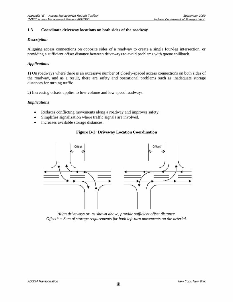
Appendix “B” – Access Management Retrofit Toolbox September 2009INDOT Access Management Guide – REVISED Indiana Department of Transportation
AECOM Transportation New York, New Yorkiii
1.3 Coordinate driveway locations on both sides of the roadway
Description
Aligning access connections on opposite sides of a roadway to create a single four-leg intersection, orproviding a sufficient offset distance between driveways to avoid problems with queue spillback.
Applications
1) On roadways where there is an excessive number of closely-spaced access connections on both sides ofthe roadway, and as a result, there are safety and operational problems such as inadequate storagedistances for turning traffic.
2) Increasing offsets applies to low-volume and low-speed roadways.
Implications
Reduces conflicting movements along a roadway and improves safety.Simplifies signalization where traffic signals are involved.Increases available storage distances.
Figure B-3: Driveway Location Coordination
Align driveways or, as shown above, provide sufficient offset distance.Offset* = Sum of storage requirements for both left-turn movements on the arterial.
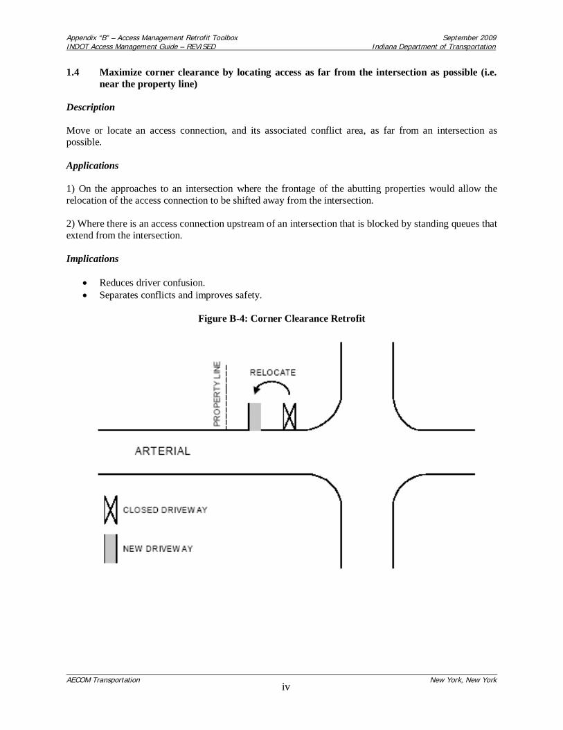
Appendix “B” – Access Management Retrofit Toolbox September 2009INDOT Access Management Guide – REVISED Indiana Department of Transportation
AECOM Transportation New York, New Yorkiv
1.4 Maximize corner clearance by locating access as far from the intersection as possible (i.e.near the property line)
Description
Move or locate an access connection, and its associated conflict area, as far from an intersection aspossible.
Applications
1) On the approaches to an intersection where the frontage of the abutting properties would allow therelocation of the access connection to be shifted away from the intersection.
2) Where there is an access connection upstream of an intersection that is blocked by standing queues thatextend from the intersection.
Implications
Reduces driver confusion.Separates conflicts and improves safety.
Figure B-4: Corner Clearance Retrofit

Appendix “B” – Access Management Retrofit Toolbox September 2009INDOT Access Management Guide – REVISED Indiana Department of Transportation
AECOM Transportation New York, New Yorkv
1.5 Provide separate left-turn entrances and exits at major traffic generators
Description
Replaces either one or two full-movement access connections with two limited-turn connections toseparate the left-turn movements to and from the site.
Applications
1) Mainly applicable on divided roadways at regional shopping centers or major traffic-generators withsignificant left-turn volumes and sufficient frontage to provide for adequate separation distances betweenthe two connections.
2) Where there is insufficient storage distance for the turning movements at the two or more existing full-movement driveways.
Implications
Reduces conflicts at each location.Where driveways are signalized, allows for two-phase signal operation.Disperses entering and exiting traffic within the development site.
Figure B-5: Left-turn Entrances and Exits at Major Traffic Generators
* = Median opening should be designed to physically prohibit the left-turn exit from the development.

Appendix “B” – Access Management Retrofit Toolbox September 2009INDOT Access Management Guide – REVISED Indiana Department of Transportation
AECOM Transportation New York, New Yorkvi
1.6 Install barriers to prevent uncontrolled access along property frontage
Description
The installation of a barrier (i.e. a guide rail or curbing) between the edge of a roadway and the parkingarea to narrow the access connection and reduce the conflict area.
Application
Strip commercial developments where the parking areas are not physically separated from the adjacentroadway, and as a result, the driveway openings are not defined.
Implications
Defines driveways and improves driveway visibility.Reduces number of conflicting movement locations and improves safety.Makes walking easier and safer for pedestrians, and allows for sidewalks.
Figure B-6: Installation of Barriers

Appendix “B” – Access Management Retrofit Toolbox September 2009INDOT Access Management Guide – REVISED Indiana Department of Transportation
AECOM Transportation New York, New Yorkvii
1.7 Install driveway channelizing island to discourage left-turn maneuvers
Description
A channelizing island is used in a driveway throat at its intersection with a roadway to restrict selectedleft-turn movements and limit the basic crossing conflicts.
Applications
1) Where left-turns are undesirable, and there is a need to restrict driveway movements to right-in/right-out on undivided roadways.
2) Where there is a high accident rate or frequency related to left-turn movements.
Implications
Eliminates left-turn conflicts where these movements are problems.Provides pedestrian refuge at high-volume driveways.May need enforcement to prevent wrong-way moves.
Figure B-7: Driveway Channelizing to Restrict Left-Turns

Appendix “B” – Access Management Retrofit Toolbox September 2009INDOT Access Management Guide – REVISED Indiana Department of Transportation
AECOM Transportation New York, New Yorkviii
2.0 Retrofit Techniques: Roadway Design
The following techniques are considered:
1) Construct or modify median to allow only left turns from a major roadway.2) Install two-way left-turn lane.3) Provide left-turn deceleration lane.4) Provide right-turn deceleration lane.5) Install right-turn deceleration lane to serve several driveways.6) Install non-traversable median with left-turn deceleration lane.
2.1 Construct or modify median to allow only left-turns from a major roadway
Description
A median opening is reconfigured to eliminate the left-turn movement from an abutting property onto theroadway.
Application
Where there are safety or operational problems caused by the left-turn egress movement from adevelopment and the re-routing of traffic that would occur as a result of the left-turn restriction could besatisfactorily accommodated.
Implications
Reduces conflicts and delays.Where only one direction of travel is signalized, signals can be installed without adverselyaffecting progression.Adequate provisions are needed for the U-turns that will be made instead of direct left-turn exits.
Figure B-8: Median Modification

Appendix “B” – Access Management Retrofit Toolbox September 2009INDOT Access Management Guide – REVISED Indiana Department of Transportation
AECOM Transportation New York, New Yorkix
2.2 Install two-way left-turn lane
Description
A flush, painted median lane for making left-turns from a roadway.
Applications
1) Roadway sections where numerous, closely-spaced, low-volume access connections exist andprojected traffic volume is less than 24,000 vehicles per day.
2) Minor urban roadways that are intended to provide access to small commercial parcels.
Implications
Removes left-turns from through travel lanes.Reduces accident rates relative to undivided cross-section.Permits use of center lane for left-turns exiting from abutting property.
Figure B-9: Installation of Two-Way Left-Turn Lane (TWLTL)

Appendix “B” – Access Management Retrofit Toolbox September 2009INDOT Access Management Guide – REVISED Indiana Department of Transportation
AECOM Transportation New York, New Yorkx
2.3 Provide left-turn deceleration lane
Description
An auxiliary left-turn lane on the roadway to remove the left-turning vehicles from the through travellanes.
Applications
1) Where it is desirable to provide a protected area for left-turning vehicles.
2) To improve traffic safety where there is a pattern of rear-end collisions or collisions involving left-turns.
Implications
Lanes may be provided by widening roadway, by placing lane within a median, or by re-stripingroadway with narrower lanes, depending upon physical conditions.Improves traffic operations and safety by removing turning vehicles from through lane.Increases capacity at signalized intersections.
Figure B-10: Left-Turn Deceleration Lane

Appendix “B” – Access Management Retrofit Toolbox September 2009INDOT Access Management Guide – REVISED Indiana Department of Transportation
AECOM Transportation New York, New Yorkxi
2.4 Provide right-turn deceleration lane
Description
An auxiliary right-turn lane on the roadway to remove the right-turning vehicles from the through travellanes.
Application
Where it is desirable to provide a protected area for right-turning vehicles. To improve traffic safetywhere there is a pattern of rear-end collisions or collisions involving right turns.
Implications
Increases capacity at signalized intersections.May not be desirable along multi-lane roads where a high volume of pedestrians are present (i.e.to avoid excessive width).
Figure B-11: Right-Turn Deceleration Lane

Appendix “B” – Access Management Retrofit Toolbox September 2009INDOT Access Management Guide – REVISED Indiana Department of Transportation
AECOM Transportation New York, New Yorkxii
2.5 Install right-turn deceleration lane to serve several driveways
Description
An auxiliary lane that removes right-turning vehicles for a series of driveways from the through travellanes.
Applications
1) Sections of roadway where the spacing of direct access connections makes the construction of separateright-turn lanes impractical.
2) Where it is desirable to remove the right-turn movements from the through travel lane to reduce delaysto the through traffic.
3) Where there has been a problem with rear-end conflicts caused by right-turning vehicles along aroadway section with numerous access connections.
Implications
Reduces speed differential between through and right-turning vehicles.Reduces delay to through vehicles.Length should be limited to discourage use by through traffic.Allows for right-in and right-out.
Figure B-12: Right-Turn Deceleration Lane Serving Several Driveways
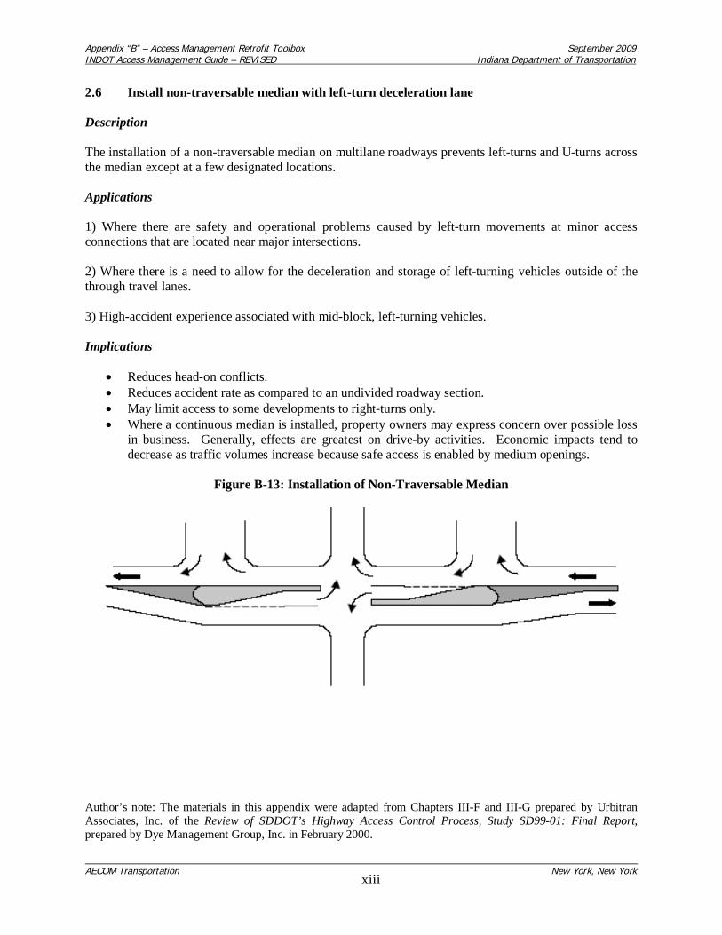
Appendix “B” – Access Management Retrofit Toolbox September 2009INDOT Access Management Guide – REVISED Indiana Department of Transportation
AECOM Transportation New York, New Yorkxiii
2.6 Install non-traversable median with left-turn deceleration lane
Description
The installation of a non-traversable median on multilane roadways prevents left-turns and U-turns acrossthe median except at a few designated locations.
Applications
1) Where there are safety and operational problems caused by left-turn movements at minor accessconnections that are located near major intersections.
2) Where there is a need to allow for the deceleration and storage of left-turning vehicles outside of thethrough travel lanes.
3) High-accident experience associated with mid-block, left-turning vehicles.
Implications
Reduces head-on conflicts.Reduces accident rate as compared to an undivided roadway section.May limit access to some developments to right-turns only.Where a continuous median is installed, property owners may express concern over possible lossin business. Generally, effects are greatest on drive-by activities. Economic impacts tend todecrease as traffic volumes increase because safe access is enabled by medium openings.
Figure B-13: Installation of Non-Traversable Median
Author’s note: The materials in this appendix were adapted from Chapters III-F and III-G prepared by UrbitranAssociates, Inc. of the Review of SDDOT’s Highway Access Control Process, Study SD99-01: Final Report,prepared by Dye Management Group, Inc. in February 2000.

Appendix “C” – Covenant Limiting Land Uses September 2009INDOT Access Management Guide – REVISED Indiana Department of Transportation
AECOM Transportation New York, New Yorki
APPENDIX “C”COVENANT LIMITING LAND USES

Covenant Limiting Land Uses
This covenant is made and entered into this______ day of___________, 20__,by______________________________ (hereinafter referred to as OWNER) and the State of Indiana,acting by and through the Indiana Department of Transportation (hereinafter referred to as INDOT).
In consideration for INDOT granting commercial driveway permit #_____________________ for theconstruction of an approach from the property described in Attachment ____ onto State Highway ______at reference post____________, the property owner hereby warrants that there will not be anydevelopment of the site that would generate traffic in excess of that which would result in the following:________________________________________________________________________________________________________________________________________________________________________________________________________________________________________________________________________________________________________________________________________________
Based on the submitted Traffic Analysis dated________________, the following land use densities arepermitted:
Land Use Size ______________________________________ _____________________________ ______________________________________ _____________________________ ______________________________________ _____________________________ ______________________________________ _____________________________ ______________________________________ _____________________________ ______________________________________ _____________________________
This covenant does not limit the owner from a change in land uses, subject to a new Traffic Analysis thatwould support that the total traffic volumes of the proposed changes do not exceed the total trafficvolumes identified in the original Traffic Analysis dated ______________.
The OWNER further covenants that no access will be granted to adjacent parcels.
These commitments may be enforced by INDOT, and INDOT may seek any legal or equitable remedy,including specific performance available under Indiana law. Any dispute with respect to thesecommitments shall be litigated in Indiana.
It is understood and agreed that this covenant shall run with the land and shall be binding upon theparties and all persons claiming under them.
____________________________________ _____________________________________ District Regulatory Supervisor Name of OWNER – Print or Type
____________________________________ _____________________________________ District Deputy Commissioner Signature of OWNER
_____________________________________Address (number and street)
_____________________________________City, State, Zip Code
_____________________________________Phone number
ACKNOWLEDGEMENT
State of Indiana, County of __________________ SS:
Before me, the undersigned Notary Public in and for the said County personally appeared
____________________________________________________________________________________ Name of Signer (print or type)
and acknowledge the execution of the foregoing contract this _____ day of _______, 20__.
Witness my hand seal the said last named date.
______________________________________My Commission Expires:
________________________________Notary Public
________________________________County of Residence
This Instrument reviewed by: __________________________________ INDOT Attorney

Appendix “D” – Future Traffic Signal Commitment September 2009INDOT Access Management Guide – REVISED Indiana Department of Transportation
AECOM Transportation New York, New Yorki
APPENDIX “D”FUTURE TRAFFIC SIGNAL COMMITMENT
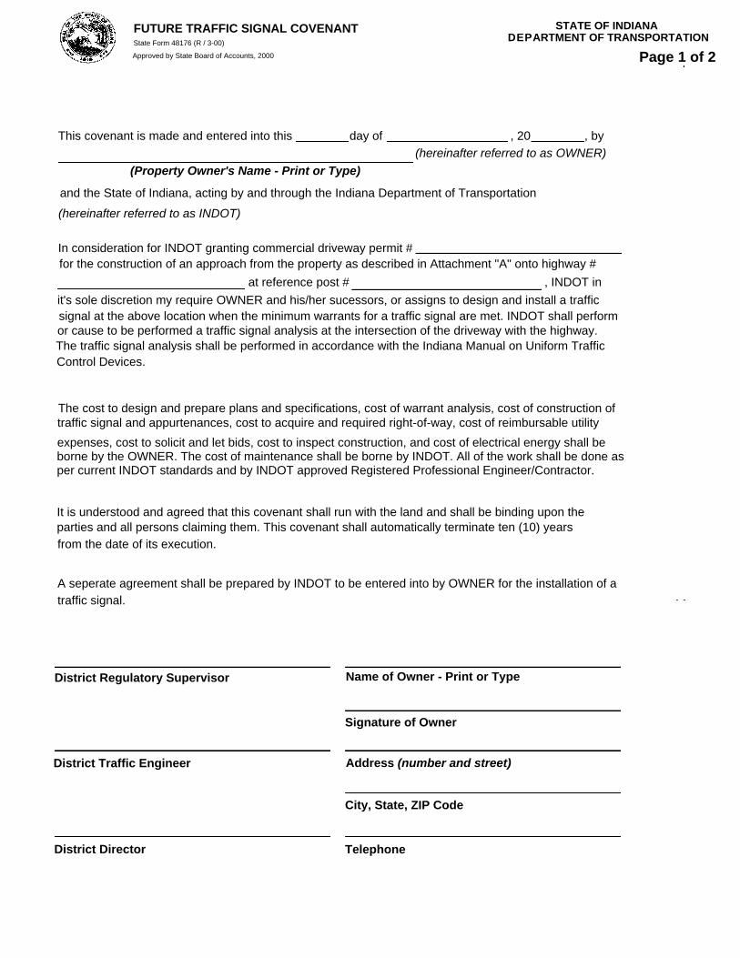
FUTURE TRAFFIC SIGNAL COVENANT STATE OF INDIANA DEPARTMENT OF TRANSPORTATIONState Form 48176 (R / 3-00)
Approved by State Board of Accounts, 2000 Page 1 of 2
This covenant is made and entered into this day of , 20 , by (hereinafter referred to as OWNER)
(Property Owner's Name - Print or Type)
and the State of Indiana, acting by and through the Indiana Department of Transportation
(hereinafter referred to as INDOT)
In consideration for INDOT granting commercial driveway permit #for the construction of an approach from the property as described in Attachment "A" onto highway # at reference post # , INDOT in
it's sole discretion my require OWNER and his/her sucessors, or assigns to design and install a trafficsignal at the above location when the minimum warrants for a traffic signal are met. INDOT shall performor cause to be performed a traffic signal analysis at the intersection of the driveway with the highway.The traffic signal analysis shall be performed in accordance with the Indiana Manual on Uniform TrafficControl Devices.
The cost to design and prepare plans and specifications, cost of warrant analysis, cost of construction oftraffic signal and appurtenances, cost to acquire and required right-of-way, cost of reimbursable utilityexpenses, cost to solicit and let bids, cost to inspect construction, and cost of electrical energy shall beborne by the OWNER. The cost of maintenance shall be borne by INDOT. All of the work shall be done asper current INDOT standards and by INDOT approved Registered Professional Engineer/Contractor.
It is understood and agreed that this covenant shall run with the land and shall be binding upon theparties and all persons claiming them. This covenant shall automatically terminate ten (10) yearsfrom the date of its execution.
A seperate agreement shall be prepared by INDOT to be entered into by OWNER for the installation of atraffic signal.
District Regulatory Supervisor
District Traffic Engineer
District Director
Name of Owner - Print or Type
Signature of Owner
Address (number and street)
City, State, ZIP Code
Telephone

STATE OF INDIANA DEPARTMENT OF TRANSPORTATION FUTURE TRAFFIC SIGNAL COVENANT
State Form 48176 (R / 3-00)
Approved by State Board of Accounts, 2000 Page 2 of 2
ACKNOWLEDGMENT
State of , County of , SS:Before me, the undersigned Notary Public in and for the said County personally appeared
(Name of Signer)and acknowledged the execution of the foregoing contract this day of ,20 . Witness my hand seal the said last named date.
My commission expires
Notary Public
County of Residence
This Instrument Reviewed by:
INDOT - ATTORNEY

Appendix “E” – MOU for Intergovernmental Cooperation in Access Management September 2009INDOT Access Management Guide – REVISED Indiana Department of Transportation
AECOM Transportation New York, New Yorki
APPENDIX “E”MEMORANDUM OF UNDERSTANDING FOR
INTERGOVERNMENTAL COOPERATION IN ACCESS MANAGEMENT

1
MEMORANDUM OF UNDERSTANDINGFOR INTERGOVERNMENTAL COOPERATION
IN ACCESS MANAGEMENT
BETWEENTHE INDIANA DEPARTMENT OF TRANSPORTATION
AND(insert of name of LOCAL PUBLIC AGENCY)
This MEMORANDUM OF UNDERSTANDING (“MOU”) is entered into this ______________day of _______________________, 2009, by and between the Indiana Department ofTransportation (“INDOT”) and the insert name (hereafter referred to asthe LOCAL PUBLIC AGENCY), and collectively referred to herein as “Party” or “Parties”.
RECITALS
WHEREAS, INDOT is responsible for building, maintaining and operating a superiorState transportation system for enhancing safety, mobility and economic growth; is responsiblefor access management on the State Highway System to preserve transportation carryingcapacity and to improve safety; and is responsible for issuing driveway or right-of-wayencroachment permits affecting access to the State Highway System; AND
WHEREAS, the LOCAL PUBLIC AGENCY is responsible for the review and approvalof the subdivision and development of lands abutting and in proximity to the State HighwaySystem; AND
WHEREAS, INDOT and the LOCAL PUBLIC AGENCY find that it is in the mutualinterest of both parties to coordinate the approval of the location, manner and design of access toand from properties abutting and in proximity to the State Highway System with the review andapproval of development and subdivision of land;
NOW, THEREFORE, the parties agree as follows:
1. INDOT’s Agreements.
a. INDOT agrees to notify the LOCAL PUBLIC AGENCY of applications fordriveway or right-of-way encroachment permits from developers to ensure thedeveloper has or will comply with local land use regulations relative to localdevelopment review and approval. (Note: This is intended to coordinate thereview of INDOT and the LOCAL PUBLIC AGENCY to ensure the approval ofone Party does not occur without the knowledge and input of the other.)
b. INDOT agrees to notify the LOCAL PUBLIC AGENCY of agreements withdevelopers concerning future signalization, roadway improvements and accesscontrol restrictions. (Note: This will enable the LOCAL PUBLIC AGNECY tohelp INDOT with agreement enforcement.)

2
c. INDOT agrees to notify the LOCAL PUBLIC AGENCY about planned roadwayimprovements prior to the execution of design contracts so that existing andplanned crossroad improvements, and access management to abutting properties,may be addressed in the scope of design.
d. INDOT agrees to involve the LOCAL PUBLIC AGENCY in design plan reviewbefore the roadway design is finalized, and prior to any public meetings orhearings, so that the treatment of existing and planned crossroad improvementsand access management to abutting properties may be reviewed.
2. LOCAL PUBLIC AGENCY Agreements.
a. The LOCAL PUBLIC AGENCY agrees to notify INDOT in the event of any ofthe following land use actions:
i. Proposed major residential subdivisions or land use re-zonings ofproperties --
1. abutting the State right-of-way, or2. with access via a local crossroad that has property with access
within a ¼-mile of the State right-of-way, and meeting INDOTwarrants for a Traffic Impact Study.
ii. New land use approvals (including special exceptions, special uses,contingent uses, conditional uses or use variances) before the local boardof zoning appeals when properties abut the State right-of-way.
iii. Proposals for minor residential subdivisions with direct access to Stateroadways. (Note: INDOT needs to verify adequate sight distance anddriveway spacing. If the road is limited access, INDOT must verifyentrance location is permitted and may require joint-use driveways orfrontage roads if proposed entrance is not permitted or violates spacingrequirements.)
b. The LOCAL PUBLIC AGENCY agrees to notify INDOT ofi. any local site plan reviews, and
ii. any local review actions concerning commercial developments(apartments, retail, office, industrial or institutional)
1. if the site abuts the State right-of-way, or2. if the site access is via a local crossroad that has property with
access within a ¼-mile of the State right-of-way and the site tripgeneration meets INDOT warrants for a Traffic Impact Study.
c. For all new buildings abutting State right-of-way (as well as expansions andchanges to existing commercial uses), the LOCAL PUBLIC AGENCY agrees tocoordinate the local building permit process with INDOT to ensure the existingdriveways can accommodate or be improved to accommodate additional sitetraffic. (Note: Sometimes, commercial drives cannot be improved toaccommodate additional site traffic.)
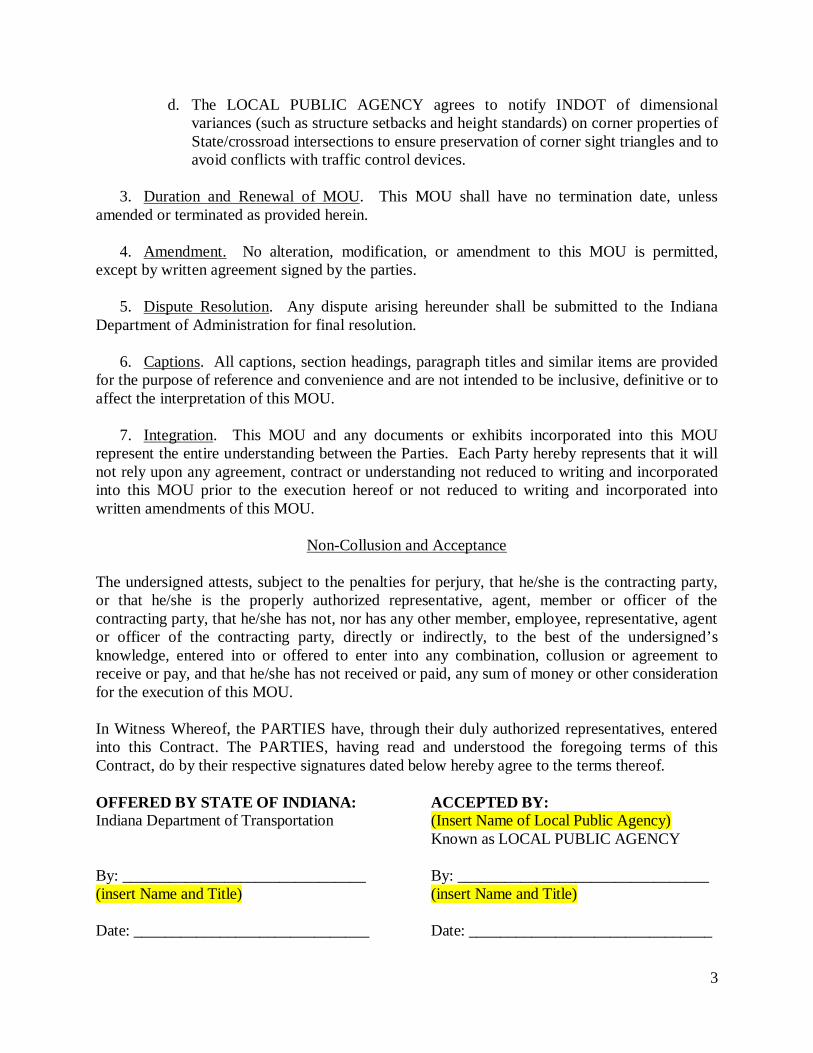
3
d. The LOCAL PUBLIC AGENCY agrees to notify INDOT of dimensionalvariances (such as structure setbacks and height standards) on corner properties ofState/crossroad intersections to ensure preservation of corner sight triangles and toavoid conflicts with traffic control devices.
3. Duration and Renewal of MOU. This MOU shall have no termination date, unlessamended or terminated as provided herein.
4. Amendment. No alteration, modification, or amendment to this MOU is permitted,except by written agreement signed by the parties.
5. Dispute Resolution. Any dispute arising hereunder shall be submitted to the IndianaDepartment of Administration for final resolution.
6. Captions. All captions, section headings, paragraph titles and similar items are providedfor the purpose of reference and convenience and are not intended to be inclusive, definitive or toaffect the interpretation of this MOU.
7. Integration. This MOU and any documents or exhibits incorporated into this MOUrepresent the entire understanding between the Parties. Each Party hereby represents that it willnot rely upon any agreement, contract or understanding not reduced to writing and incorporatedinto this MOU prior to the execution hereof or not reduced to writing and incorporated intowritten amendments of this MOU.
Non-Collusion and Acceptance
The undersigned attests, subject to the penalties for perjury, that he/she is the contracting party,or that he/she is the properly authorized representative, agent, member or officer of thecontracting party, that he/she has not, nor has any other member, employee, representative, agentor officer of the contracting party, directly or indirectly, to the best of the undersigned’sknowledge, entered into or offered to enter into any combination, collusion or agreement toreceive or pay, and that he/she has not received or paid, any sum of money or other considerationfor the execution of this MOU.
In Witness Whereof, the PARTIES have, through their duly authorized representatives, enteredinto this Contract. The PARTIES, having read and understood the foregoing terms of thisContract, do by their respective signatures dated below hereby agree to the terms thereof.
OFFERED BY STATE OF INDIANA: ACCEPTED BY:Indiana Department of Transportation (Insert Name of Local Public Agency)
Known as LOCAL PUBLIC AGENCY
By: _______________________________ By: ________________________________(insert Name and Title) (insert Name and Title)
Date: ______________________________ Date: _______________________________