Abrolhos Island map - Department of Fisheries and graphs/abrolhos_Isla… · APPENDIX 2 THE HOUTMAN...
1
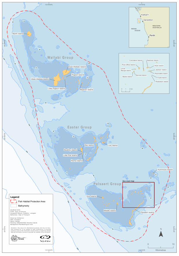
! ! ! ! ! ! ! ! ! ! ! ! ! ! ! ! ! ! ! ! ! ! ! ! ! ! ! ! ! ! ! ! ! ! ! ! ! ! ! ! ! ! ! ! ! ! ! ! ! ! ! ! ! ! ! ! ! ! ! ! ! ! ! ! ! ! ! ! ! ! ! ! ! ! ! ! ! ! ! ! ! ! ! ! ! ! ! ! ! ! ! ! ! ! ! ! ! ! ! ! ! ! ! ! ! ! ! ! ! ! ! ! ! ! ! ! ! ! ! ! ! ! ! ! ! ! ! ! ! ! ! ! ! ! ! ! ! ! ! ! ! ! ! ! ! ! ! ! ! ! ! ! ! ! ! ! ! ! ! ! ! ! ! ! ! ! ! ! ! ! ! ! ! ! ! ! ! ! ! ! ! ! ! ! ! ! ! ! ! ! ! ! ! ! ! ! ! ! ! ! ! ! ! ! ! ! 10 50 20 50 100 10 50 100 20 10 50 50 10 200 50 100 500 50 20 20 20 10 20 20 10 200 10 20 Wallabi Group Easter Group Pelsaert Group Rat Island Leo Island Gun Island Roma Island North Island Bushby Island Pigeon Island Middle Island Beacon Island Hummock Island Pelsaert Island Little Rat Island West Wallabi Island East Wallabi Island Little Pigeon Island 114°0'0"E 114°0'0"E 113°40'0"E 113°40'0"E 28°20'0"S 28°20'0"S 28°40'0"S 28°40'0"S 29°0'0"S 29°0'0"S Disclaimer: This map is for informational purposes and may not have been prepared for, or be suitable for legal, engineering, or surveying purposes. Users of this information should review or consult the primary data and information sources to ascertain the usability of the information. SOURCE DATA FHPA: Dept. of Fisheries Geographic Names, Coastline: Landgate Bathymetry: Dept. of Transport Drawn by: N.Shannon Date: 12/10/2011 Datum: GDA94 Filestring: 20602003\0001-Abrolhos Islands Management Plan\Mxd\Figure1.mxd Legend ! ! ! ! Fish Habitat Protection Area Bathymetry 0 10 Kilometres ¯ " " " INDIAN OCEAN WESTERN AUSTRALIA Perth Geraldton Kalbarri Nook Island Foale Island Newman Island Basile Island Jackson Island Robertson Island Post Office Island Burnett Island Rotondella Island Coronation Island Uncle Margie Island See inset map 0 2 1 km
Transcript of Abrolhos Island map - Department of Fisheries and graphs/abrolhos_Isla… · APPENDIX 2 THE HOUTMAN...
20 Fisheries Management Paper No.260
APPENDIX 2 THE HOUTMAN ABROLHOS ISLAND GROUPS
!
!
!
!
!
!
!
!
!
!
!
!
!
!
!
!
!
!
!
!
!
!
!
!
!
!
!
!
!
!
!
!
!
!
!
!
!
!
!
!
!
!
!
!
!
!
!
!
!
!
!
!
!
!
!
!
!
!
!
!
!
!!
!
!
!
!
!
!
!
!
!
!
!
!
!
!
!
!
!
!
!
!
!
!
!
!
!
!!
!
!
!
!
!
!
!
!
!
!
!
!
!
!
!
!
!
!
!
!
!
!
!
!
!
!
!!
!
!
!
!
!
!!
!
!
!
!
!
!
!
!!
!!
!
!!
!
!
!
!
!
!
!
!
!
!
!
!
!
!
!
!
!
!
!
!
!
!
!
!
! !
!
!
!
!
!
!
!
!
!
!
!
!
!
!
!
!
!
!
!
!
!
!
!
!
!
!
!
!
!
!
!
!
!
!
!
!
!
!
!
!
!
10
50
20
50
100
10
50
100
20
10
50
50
10200
50
100
500
50
20
20
20
10
20
20
10200
10
20
Wa l l a b i G r o u p
E a s t e r G r o u p
P e l s a e r t G r o u p
Rat Island Leo Island
Gun Island
Roma Island
North Island
Bushby Island
Pigeon Island
Middle Island
Beacon Island
Hummock Island
Pelsaert Island
Little Rat Island
West Wallabi Island
East Wallabi Island
Little Pigeon Island
114°0'0"E
114°0'0"E
113°40'0"E
113°40'0"E28
°20'
0"S
28°2
0'0"
S
28°4
0'0"
S
28°4
0'0"
S
29°0
'0"S
29°0
'0"SDisclaimer: This map is for informational purposes and may not have
been prepared for, or be suitable for legal, engineering, or surveyingpurposes. Users of this information should review or consult the primarydata and information sources to ascertain the usability of the information.
SOURCE DATAFHPA: Dept. of FisheriesGeographic Names, Coastline: LandgateBathymetry: Dept. of Transport
Drawn by: N.ShannonDate: 12/10/2011Datum: GDA94Filestring: 20602003\0001-Abrolhos Islands Management Plan\Mxd\Figure1.mxd
Legend
!
! !
!
Fish Habitat Protection Area
Bathymetry
0 10
Kilometres
¯
"
"
"
INDIAN OCEAN
WESTERN AUSTRALIA
Perth
Geraldton
Kalbarri
Nook Island
Foale Island
Newman Island
Basile Island
Jackson Island
Robertson Island
Post Office Island
Burnett IslandRotondella Island
Coronation Island
Uncle Margie Island
See inset map
0 21 km