ABoVE Standard Projection and Reference Grid v2 20170621
6
ABoVE Standard Projection and Reference Grid Justification The ABoVE field campaign will provide the opportunity to expand and coordinate a set of focused, interdisciplinary research activities designed to further understand the causes and consequences of change in the social-ecological systems of the Arctic and boreal regions of western North America. The campaign is expected to result in the development of multiple geospatial datasets. To facilitate data interoperability, a standard projection and reference grid have been proposed to cover the ABoVE study domain. The domain for the study area is over 6.3 x 10 6 km 2 as shown in the red and purple outlines in Figure 1. Thematic data products will be generated from field measurements, flux towers, airborne remote sensors and satellite remote sensing data. The datasets will range considerably in resolution, format, geographic extent, projection and/or reference system. This variability in ABoVE datasets is likely to place a considerable burden on individual researchers as they will need to standardize the incoming datasets to support geospatial analysis, thus leading to duplicated effort across research groups utilizing these products. This duplication of effort will continue to propagate as outcomes of scientific analysis from individual research groups will require subsequent standardization to support their further inclusion in ABoVE science projects. Implementing a standard projection and grid would enable the producers of the data to align and subdivide data products in order to ease archiving and distribution of datasets (both for long-term archiving of the data and near-term use throughout the campaign’s duration), and would simplify data standardization for scientific analysis within ABoVE. This compatibility across multiple datasets will facilitate interoperability of the datasets in scientific analysis, and is an important benefit of the standardized projection and reference grid. Additionally, it is expected that many data products will be generated with medium to fine resolution (30m spatial resolution or less) imagery and hence would be too large to distribute to users as single files covering the entire study region. Where the projection provides a mechanism to ensure that the products are geometrically compatible, the reference grid provides a standardized way to break the files up into units that are easy to download and manipulate by the researchers. The approach taken here is modeled after the MODIS standard products. Below is a list of assumptions that were used when determining the projection and grid: 1. While the projection would be applicable to multiple data types, the grid would primarily be used for raster products produced over the study domain (not including circumpolar datasets). 2. To provide areal calculations from the data products we need to have the data in an equal area projection. 3. The products could range from fine spatial resolution (1 – 5m) to coarse spatial resolution (250m or more). 4. 30m will be a central spatial resolution. 5. Users of raster data can easily download files that are 300MB in size.
Transcript of ABoVE Standard Projection and Reference Grid v2 20170621

ABoVE Standard Projection and Reference Grid Justification The ABoVE field campaign will provide the opportunity to expand and coordinate a set of focused,interdisciplinary research activities designed to further understand the causes and consequences ofchangeinthesocial-ecologicalsystemsoftheArcticandborealregionsofwesternNorthAmerica.Thecampaign is expected to result in thedevelopmentofmultiple geospatial datasets. To facilitatedatainteroperability,astandardprojectionandreferencegridhavebeenproposedtocovertheABoVEstudydomain.
Thedomainforthestudyareaisover6.3x106km2asshownintheredandpurpleoutlinesinFigure1.Thematic data products will be generated from field measurements, flux towers, airborne remotesensorsandsatellite remotesensingdata. Thedatasetswill rangeconsiderably in resolution, format,geographic extent, projection and/or reference system. This variability in ABoVE datasets is likely toplace a considerable burden on individual researchers as theywill need to standardize the incomingdatasetstosupportgeospatialanalysis,thusleadingtoduplicatedeffortacrossresearchgroupsutilizingtheseproducts.Thisduplicationofeffortwill continue topropagateasoutcomesof scientificanalysisfrom individual research groups will require subsequent standardization to support their furtherinclusion in ABoVE science projects. Implementing a standard projection and grid would enable theproducersofthedatatoalignandsubdividedataproductsinordertoeasearchivinganddistributionofdatasets (both for long-term archiving of the data and near-term use throughout the campaign’sduration), and would simplify data standardization for scientific analysis within ABoVE. Thiscompatibilityacrossmultipledatasetswillfacilitateinteroperabilityofthedatasetsinscientificanalysis,andisanimportantbenefitofthestandardizedprojectionandreferencegrid.
Additionally, it isexpectedthatmanydataproductswillbegeneratedwithmediumto fineresolution(30mspatial resolutionor less) imageryandhencewouldbe too large todistribute tousersas singlefilescoveringtheentirestudyregion. Wheretheprojectionprovidesamechanismtoensurethattheproductsaregeometricallycompatible,thereferencegridprovidesastandardizedwaytobreakthefilesupintounitsthatareeasytodownloadandmanipulatebytheresearchers.
TheapproachtakenhereismodeledaftertheMODISstandardproducts.Belowisalistofassumptionsthatwereusedwhendeterminingtheprojectionandgrid:
1. While the projectionwould be applicable tomultiple data types, the gridwould primarily beusedforrasterproductsproducedoverthestudydomain(notincludingcircumpolardatasets).
2. Toprovidearealcalculationsfromthedataproductsweneedtohavethedatainanequalareaprojection.
3. Theproductscouldrangefromfinespatialresolution(1–5m)tocoarsespatialresolution(250mormore).
4. 30mwillbeacentralspatialresolution.5. Usersofrasterdatacaneasilydownloadfilesthatare300MBinsize.
Standard Projection The projection for use and archiving of geospatial data products for the ABoVE study domain is theCanadaAlbersEqualAreaprojection.Thisprojectionhasbeenselectedbecauseitisequalarea,iswidelysupported in geospatial software (ESRI, ENVI, gdal, etc), is commonly used for data products in thisregion,andhascentralmeridianandparallelswithinthehighnorthernlatitudeareasthatarethefocusoftheABoVEcampaign.
Projection Specifications: Canada_Albers_Equal_Area_ConicWKID(EPSG):102001Authority:ESRIProjection: AlbersFalse_Easting:0.0False_Northing:0.0Central_Meridian:-96.0Standard_Parallel_1:50.0Standard_Parallel_2:70.0Latitude_Of_Origin:40.0LinearUnit:Meter(1.0)GeographicCoordinateSystem:GCS_North_American_1983AngularUnit:Degree(0.0174532925199433)PrimeMeridian:Greenwich(0.0)Datum:North_American_1983Spheroid:GRS_1980SemimajorAxis:6378137.0SemiminorAxis:6356752.314140356InverseFlattening:298.257222101
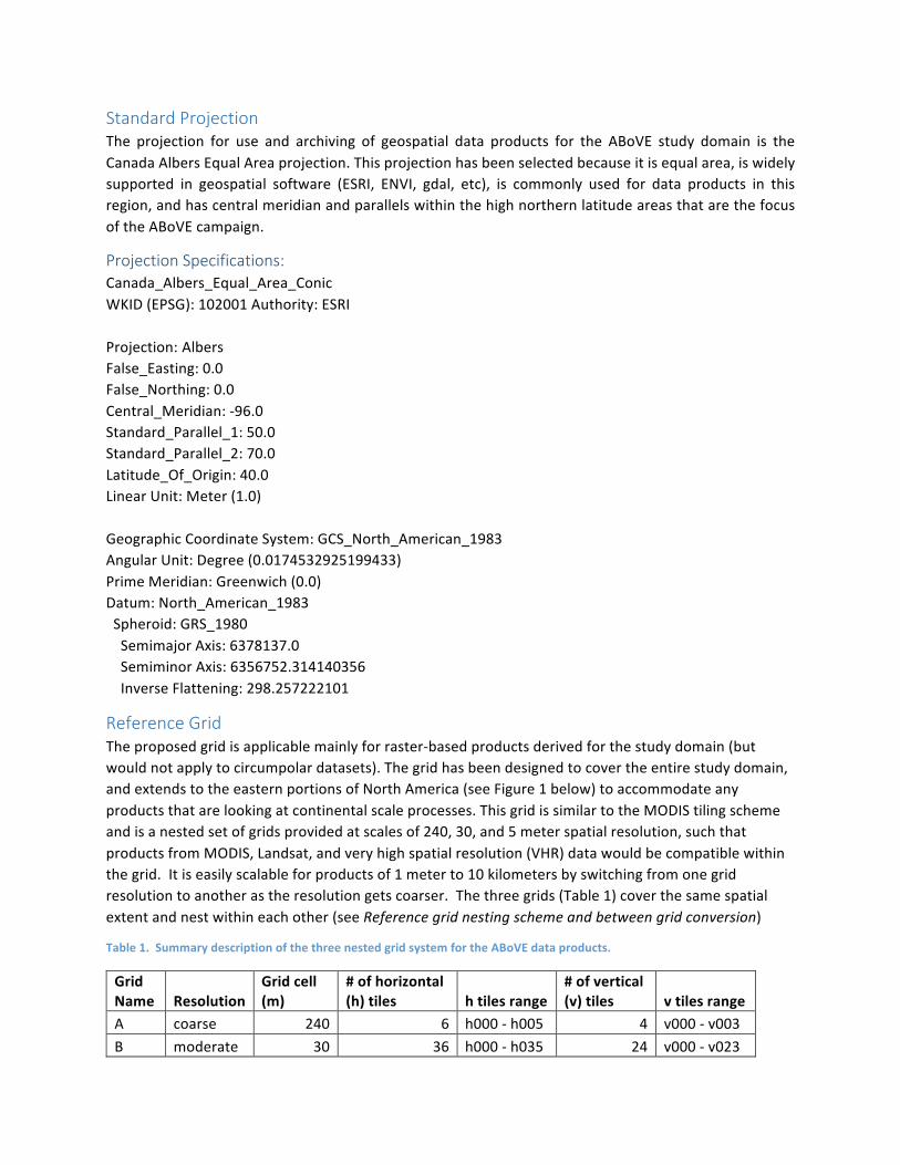
Reference Grid Theproposedgridisapplicablemainlyforraster-basedproductsderivedforthestudydomain(butwouldnotapplytocircumpolardatasets).Thegridhasbeendesignedtocovertheentirestudydomain,andextendstotheeasternportionsofNorthAmerica(seeFigure1below)toaccommodateanyproductsthatarelookingatcontinentalscaleprocesses.ThisgridissimilartotheMODIStilingschemeandisanestedsetofgridsprovidedatscalesof240,30,and5meterspatialresolution,suchthatproductsfromMODIS,Landsat,andveryhighspatialresolution(VHR)datawouldbecompatiblewithinthegrid.Itiseasilyscalableforproductsof1meterto10kilometersbyswitchingfromonegridresolutiontoanotherastheresolutiongetscoarser.Thethreegrids(Table1)coverthesamespatialextentandnestwithineachother(seeReferencegridnestingschemeandbetweengridconversion)
Table1.SummarydescriptionofthethreenestedgridsystemfortheABoVEdataproducts.
GridName Resolution
Gridcell(m)
#ofhorizontal(h)tiles htilesrange
#ofvertical(v)tiles vtilesrange
A coarse 240 6 h000-h005 4 v000-v003B moderate 30 36 h000-h035 24 v000-v023
C fine 5 216 h000-h215 144 v000-v143
Figure1TheABoVEreferencegridandstudydomain.a)The240mreferencegrid(4500X4500gridcellspertile)withassociatedAhandAvvaluesandb)The30mreferencegrid(6000X6000gridcellspertile)superimposedonthe“A”grid.
GriddedABoVEdatasetsoftheextentlargerthan100X100km2aretobeproducedinthisgridandprojection(thisisroughlyaLandsattile).Also,werecognizethatatveryhighresolution,reprojectionof
originaldatacanresultinsubstantialspatialshiftsinorientation,location,andshapeofsmallobjects;therefore,scienceteammembersareencouragedtosubmittheirfine-scaledatasetsintheoriginalprojectioninadditiontotheABoVEgridformat(iftheextentoftheirdatasetisgreaterorequalto10,000km2)oronlyintheoriginalprojectionifitissmallerthanthatsize.
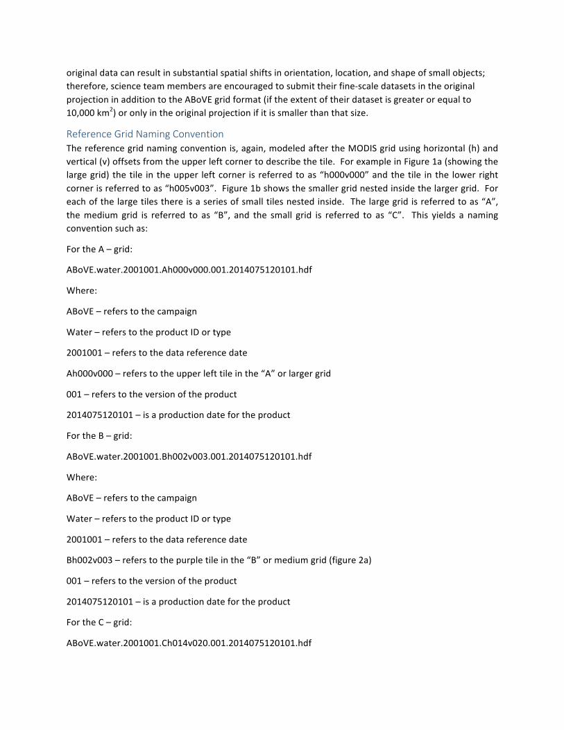
Reference Grid Naming Convention Thereferencegridnamingconventionis,again,modeledaftertheMODISgridusinghorizontal(h)andvertical(v)offsetsfromtheupperleftcornertodescribethetile.ForexampleinFigure1a(showingthelargegrid) thetile intheupper leftcorner is referredtoas“h000v000”andthetile inthe lowerrightcornerisreferredtoas“h005v003”.Figure1bshowsthesmallergridnestedinsidethelargergrid.Foreachofthelargetilesthereisaseriesofsmalltilesnestedinside.Thelargegridisreferredtoas“A”,themedium grid is referred to as “B”, and the small grid is referred to as “C”. This yields a namingconventionsuchas:
FortheA–grid:
ABoVE.water.2001001.Ah000v000.001.2014075120101.hdf
Where:
ABoVE–referstothecampaign
Water–referstotheproductIDortype
2001001–referstothedatareferencedate
Ah000v000–referstotheupperlefttileinthe“A”orlargergrid
001–referstotheversionoftheproduct
2014075120101–isaproductiondatefortheproduct
FortheB–grid:
ABoVE.water.2001001.Bh002v003.001.2014075120101.hdf
Where:
ABoVE–referstothecampaign
Water–referstotheproductIDortype
2001001–referstothedatareferencedate
Bh002v003–referstothepurpletileinthe“B”ormediumgrid(figure2a)
001–referstotheversionoftheproduct
2014075120101–isaproductiondatefortheproduct
FortheC–grid:
ABoVE.water.2001001.Ch014v020.001.2014075120101.hdf
Where:
ABoVE–referstothecampaign
Water–referstotheproductIDortype
2001001–referstothedatareferencedate
Ch014v020–referstothegreentileinthe“C”orfinegrid(figure2b)
001–referstotheversionoftheproduct
2014075120101–isaproductiondatefortheproduct
Figure2A)ThelocationofsampletileBh002v003(inpurple)withinboththelarger“A”grid(inbold)andthesmaller“B”grid.B)thelocationofsampletileCh014v020withinthelargertwogridsisshown.
Tosimplifydownstreamprocessingitisrecommendedthatallproductsusethreedigitidentifiersforallgridtileidentifiers(i.e.Ch014v020insteadofh14v20)tofacilitatescriptinginanalyseslateron.
Reference grid nesting scheme and between grid conversion Thenestingschemeprovidesastandardizedandstraightforwardtilingpatternwhereeachofthelargertilesiscomposedfrom6X6(36)smallertilesofthesmallergridsystem.Forexample,asingletileforthecoarseresolutionA-gridiscontains6X6(36)tilesofB-grid.Similarly,eachsingletileofB-gridcontains6X6(36)tilesofC-grid.Simplecalculationscanbeusedtotranslatebetweenresolutions.Forexample:
TofindthelocationofagiventheC-gridtileCh036v012withinB-grid,thehorizontal(h036)andvertical(v012)componentsofthetilenumberingshouldbedividedby6:
floor(36/6)=6andfloor(12/6=2) (“floor”isamathfunctionthattruncatesfloatingpointvaluestointegerswithoutrounding)
HenceCh036v012isfoundinBh006v002.ThepositionofaC-gridtilewithintheA-gridcanbedeterminedinasimilarwaybydividinghandvcomponentsby36:
floor(36/36)=1andfloor(12/36)=0

HenceCh036v012isinAh001v000.TranslatingfromtheB-gridtotheA-gridisthesameastranslatingfromC-gridtoB-grid,simplydividehandvby6.
GivenBh010v008:
floor(10/6)=1andfloor(8/6)=1
HenceBh010v008isinAh001v001.Thissimpletranslationmethodcanfacilitateanalysisthatrequiresusingmultipleproductsatvaryingspatialresolutions.AusercanalsosimplyquerytheassociatedshapefilesusingGISsoftwaretofindwhereafinerresolutiontilenestswithinthecoarserresolutiongrids.AshapefileforeachofthethreegridsisavailablefromtheOakRidgeNationalLaboratoryDAACorfromtheABoVEwebsite.Forfurtherinformationorquestionsregardingtheprojectionorgridpleasecontactsupport@cce.nasa.gov.