Aboriginal memories of inundation of the Australian … memories of inundation of the Australian...
37
Aboriginal memories of inundation of the Australian coast dating from more than 7000 years ago Nicholas Reid Northern Institute, Charles Darwin University 01.09.15
Transcript of Aboriginal memories of inundation of the Australian … memories of inundation of the Australian...
Aboriginal memories of inundation of the
Australian coast dating from more than 7000 years ago
Nicholas Reid Northern Institute, Charles Darwin University
01.09.15

Oral Traditions and Sea-Level Change
Academically oriented history, as conceived of within literate cultures, once drew a clean line between ‘documented facts’ and ‘oral traditions’, and viewed the latter as having dubious worth over any significant time depth.
Most scientists hold a fairly sceptical view of ‘deep’ oral histories (Henige 2009), others regard that as unduly cautious (Echo-Hawk 2000).
In recent decades however, the idea that oral traditions might contribute to an understanding of natural phenomena has begun to gain increasing acceptance (Vitaliano, 1973; Piccardi & Masse, 2007).

Oral Traditions and Sea-Level Change
Klamath traditions about the eruption of Mt Mazama in Oregon, USA, which appear to have endured in recognisable form for more than 7000 years.
Other traditions concerning now-extinct animals and extra-terrestrial objects are increasingly being considered as candidates for phenomena based on genuine observation.
Flooding events are good candidates to enter the oral tradition canon precisely because of their cataclysmic nature and great, and usually negative, impacts on the lives of people.
Sea level rise traditions … surprisingly distributed.
Oral Traditions and Sea-Level Change
Changes in post-glacial sea levels around the Australian coast are now well established.
Marine geographers can now point to specific parts of the Australian coast and say with considerable confidence that ‘Given known bathymetry, the sea here was X metres lower than present levels at Y time depth before the present day (BP)’.
However, there has been scant attention paid by the scientific community to how Indigenous oral traditions compare with these new scientifically informed sea-level change chronologies, despite the fact that Australia provides a surprisingly large number of relevant traditions.
Postglacial Australia: People and Sea Level
People arrived in Australia at least 50,000–40,000 years BP (O’Connell & Allen, 1998), certainly before the Last Glacial Maximum (26,000 to 20,000 BP) when sea level reached its lowest point (120m below present).
After the end of the Last Glacial Maximum, through the period 20,000–7,000 BP, the sea level rose (not always steadily) until about 7,000–6,000 years BP when it reached a maximum around most parts of Australia.
Over the last 6,000 years sea levels have been stable or trending downwards slightly (by about a metre).
Prior to the sea-level high, say 20,000–7,000 BP, Aboriginal people occupied coastal environments which have since been covered by the sea, and in many cases buried by sediment. Such sites represent a part of the prehistoric record that is lost forever (Allen & Kershaw, 1996).
Postglacial Australia: People and Sea Level
“25% of greater Australia was drowned, almost 2.5 million square kilometres of land was lost over a 13,000-year period. The average loss was over 190 square kilometres of land each year … The Bassian plain was inundated …the seas invaded Lake Carpentaria … the sea rushed across the Pilbara and Nullarbor plains” (Cane, 2013, p195-6)
Lots of interesting questions about the social/political/cultural consequences of people adapting to 13,000 years of semi-steady sea-level rise. Generation after generation must have had to renegotiate land tenure arrangements with inland neighbours, and make stay-or-go decisions about island/lowland clan estates.
So while the noteworthiness of slow inexorable sea-level rise might appear to pale against sudden flooding events, Australian Aborigines must have lived with high levels of awareness that inundation was taking place, and had been so for a long time.
We might have an expectation that such high-impact climatic change would emerge in oral tradition, but is that possible across 7,000+ yr time-depth?

Stories about Aboriginal peoples’ interactions with the coast
Oral traditions describing coastal change and the associated disruptions of coastal livelihoods. Such traditions tend to come in one of two forms: 1. stories of narrated historical fact without obvious
embellishment 2. or as myths in which observed changes are attributed to the
acts of ancestral beings
As presented here, these traditions are from written records of orally-transmitted knowledge that date from early in the post-European contact history of Australia after 1788 when “curious, observant, and relatively unprejudiced individuals in all parts of Australia wrote down descriptions of Aboriginal ceremonies, recorded versions of Aboriginal myths and tales and sometimes gave the texts and even occasionally the musical scores of songs” (Clunies Ross, 1986: 233).
Stories about Aboriginal people’s interactions with the coast
The Australian coastal traditions are generally of two thematic types:
1. stories about how a prior single landmass came to be two landmasses separated by a water gap. Here we discuss Fitzroy Island (Queensland) as such an example.
2. stories about how people could once cross a water gap by wading or swimming where such a feat would be impossible today. Here we discuss Rottnest Island (Western Australia) as such an example.
This larger project has unearthed a considerable number (21) of such traditions. For this talk I’ll discuss just the two listed above in some detail, and list in truncated form the assumed sea levels and dates for four others: Spencer Gulf, Bathurst and Melville Islands, Kangaroo Island, and Port Phillip Bay.
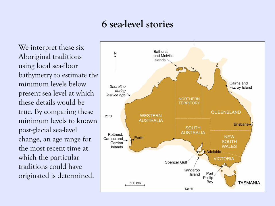
6 sea-level stories
We interpret these six Aboriginal traditions using local sea-floor bathymetry to estimate the minimum levels below present sea level at which these details would be true. By comparing these minimum levels to known post-glacial sea-level change, an age range for the most recent time at which the particular traditions could have originated is determined.
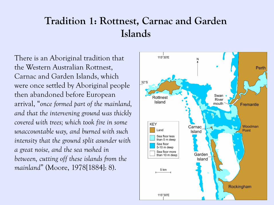
Tradition 1: Rottnest, Carnac and Garden Islands
There is an Aboriginal tradition that the Western Australian Rottnest, Carnac and Garden Islands, which were once settled by Aboriginal people then abandoned before European arrival, “once formed part of the mainland, and that the intervening ground was thickly covered with trees; which took fire in some unaccountable way, and burned with such intensity that the ground split asunder with a great noise, and the sea rushed in between, cutting off these islands from the mainland” (Moore, 1978[1884]: 8).

Tradition 1: Rottnest, Carnac and Garden Islands
For Rottnest island, the sea level would have to have been 7–8m lower than present if walkers kept to the (now-shallower) middle parts of the routes. Both Carnac and Garden Islands could have been reached when the sea level was 5m shallower than present. Assuming that the tradition derives from an observation during a time when sea level was at least 7–8m below present, then this tradition must date from at least 8,900 –7,500 years BP.
Tradition 2: Fitzroy Island
Off the coast of northern Queensland lies the Great Barrier Reef. In the Cairns region, where the edge of the Great Barrier Reef is 50km from shore, an early report states that “the Googanji natives … say that before the flood the Barrier Reef was the original coastline, and that a river entered the sea near what is known as Fitzroy Island” (Gribble, 1933: 7). More details come from a later story collected from the Yidindji people –
“A theme running through all the coastal Yidinj myths is that the coastline was once where the barrier reef now stands … but the sea then rose and the shore retreated to its present position. … The proper name of Fitzroy Island is gabar ‘lower arm’, so called because most of this geographical feature [a promontory of the mainland] was submerged and only one extension remains above water. Note also that there was a place half-way between Fitzroy Island and King Beach that was called mudaga (‘pencil cedar’) after the trees which grew there; it is now completely submerged. Again Green Island is said to have been at one time four times as big as it is now – only the northwest portion remains above water. (Dixon, 1977: 14-15)
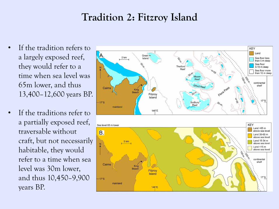
Tradition 2: Fitzroy Island
• If the tradition refers to a largely exposed reef, they would refer to a time when sea level was 65m lower, and thus 13,400–12,600 years BP.
• If the traditions refer to
a partially exposed reef, traversable without craft, but not necessarily habitable, they would refer to a time when sea level was 30m lower, and thus 10,450–9,900 years BP.
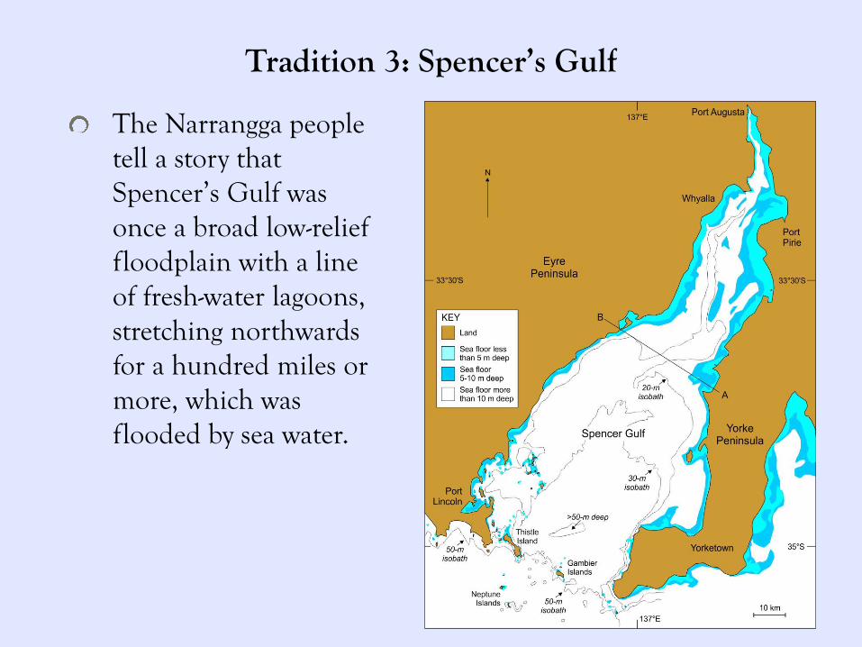
Tradition 3: Spencer’s Gulf
The Narrangga people tell a story that Spencer’s Gulf was once a broad low-relief floodplain with a line of fresh-water lagoons, stretching northwards for a hundred miles or more, which was flooded by sea water.
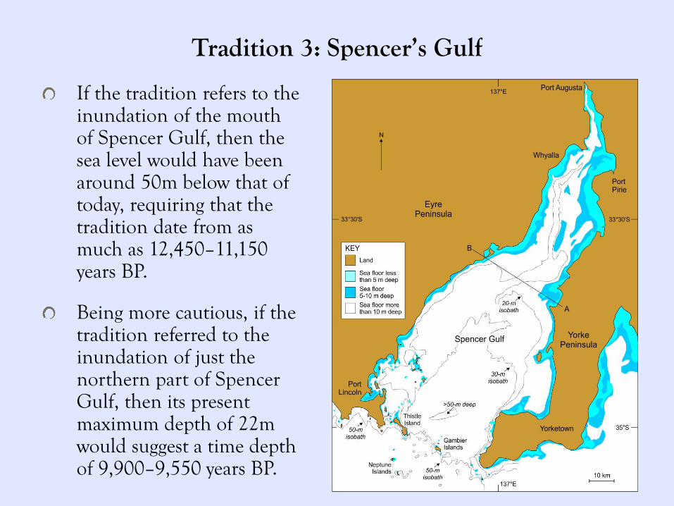
Tradition 3: Spencer’s Gulf
If the tradition refers to the inundation of the mouth of Spencer Gulf, then the sea level would have been around 50m below that of today, requiring that the tradition date from as much as 12,450–11,150 years BP.
Being more cautious, if the tradition referred to the inundation of just the northern part of Spencer Gulf, then its present maximum depth of 22m would suggest a time depth of 9,900–9,550 years BP.
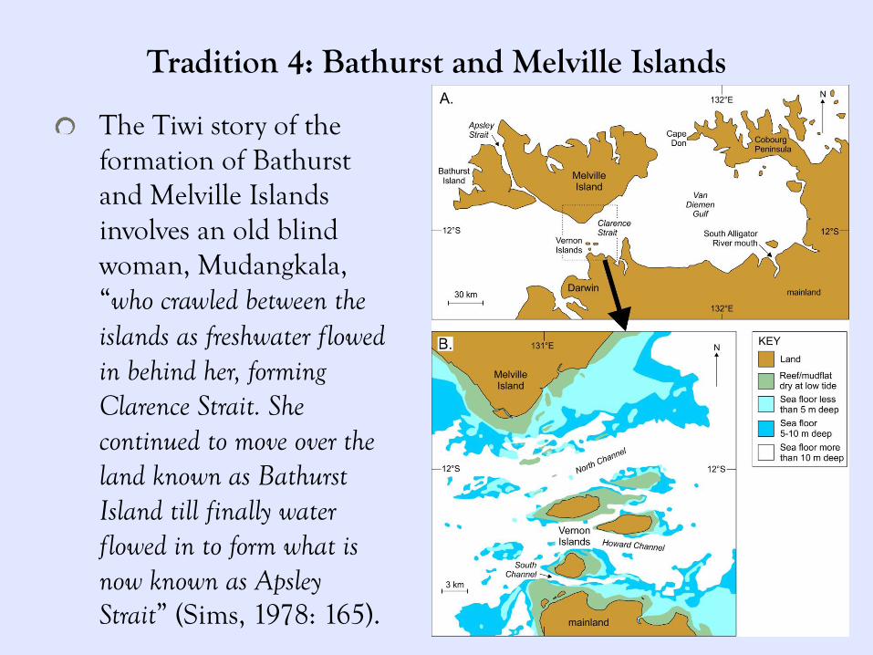
Tradition 4: Bathurst and Melville Islands
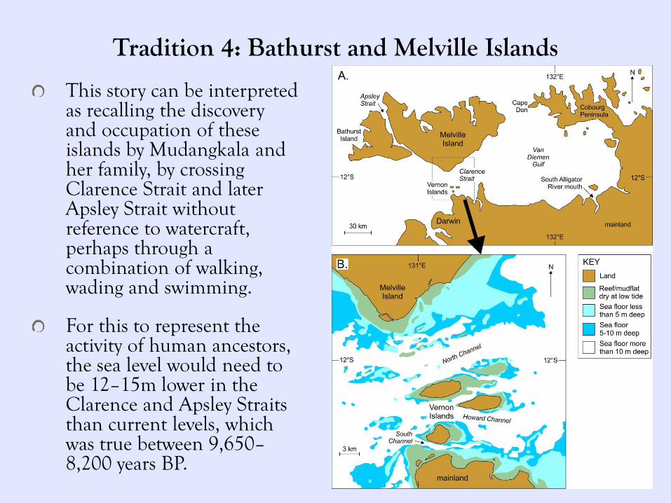
The Tiwi story of the formation of Bathurst and Melville Islands involves an old blind woman, Mudangkala, “who crawled between the islands as freshwater flowed in behind her, forming Clarence Strait. She continued to move over the land known as Bathurst Island till finally water flowed in to form what is now known as Apsley Strait” (Sims, 1978: 165).
Tradition 4: Bathurst and Melville Islands
This story can be interpreted as recalling the discovery and occupation of these islands by Mudangkala and her family, by crossing Clarence Strait and later Apsley Strait without reference to watercraft, perhaps through a combination of walking, wading and swimming.
For this to represent the activity of human ancestors, the sea level would need to be 12–15m lower in the Clarence and Apsley Straits than current levels, which was true between 9,650–8,200 years BP.
Tradition 5: Kangaroo Island
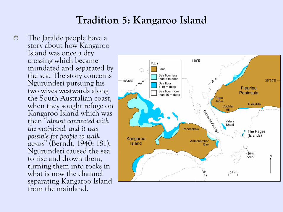
The Jaralde people have a story about how Kangaroo Island was once a dry crossing which became inundated and separated by the sea. The story concerns Ngurunderi pursuing his two wives westwards along the South Australian coast, when they sought refuge on Kangaroo Island which was then “almost connected with the mainland, and it was possible for people to walk across” (Berndt, 1940: 181). Ngurunderi caused the sea to rise and drown them, turning them into rocks in what is now the channel separating Kangaroo Island from the mainland.
Tradition 5: Kangaroo Island
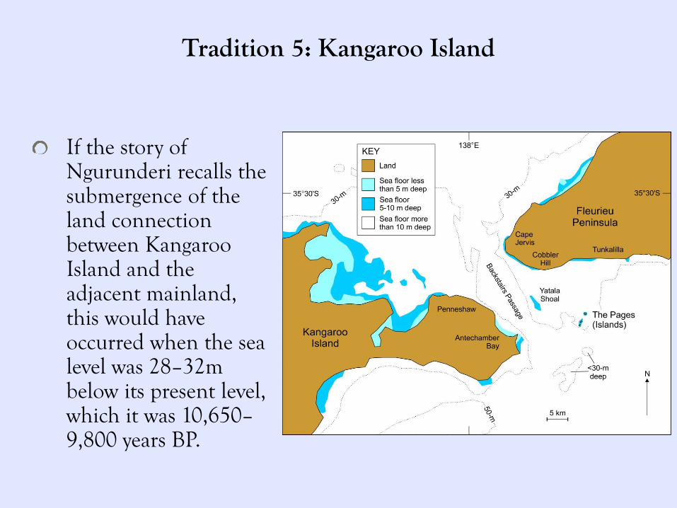
If the story of Ngurunderi recalls the submergence of the land connection between Kangaroo Island and the adjacent mainland, this would have occurred when the sea level was 28–32m below its present level, which it was 10,650–9,800 years BP.
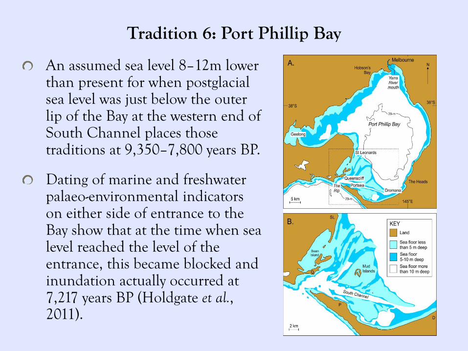
Tradition 6: Port Phillip Bay
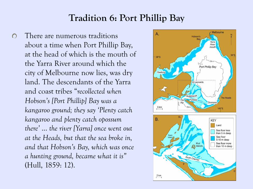
There are numerous traditions about a time when Port Phillip Bay, at the head of which is the mouth of the Yarra River around which the city of Melbourne now lies, was dry land. The descendants of the Yarra and coast tribes “recollected when Hobson’s [Port Phillip] Bay was a kangaroo ground; they say ‘Plenty catch kangaroo and plenty catch opossum there’ … the river [Yarra] once went out at the Heads, but that the sea broke in, and that Hobson’s Bay, which was once a hunting ground, became what it is” (Hull, 1859: 12).
Tradition 6: Port Phillip Bay
An assumed sea level 8–12m lower than present for when postglacial sea level was just below the outer lip of the Bay at the western end of South Channel places those traditions at 9,350–7,800 years BP.
Dating of marine and freshwater palaeo-environmental indicators on either side of entrance to the Bay show that at the time when sea level reached the level of the entrance, this became blocked and inundation actually occurred at 7,217 years BP (Holdgate et al., 2011).
Tradition 6: Port Phillip Bay
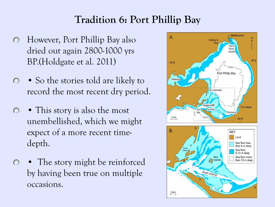
However, Port Phillip Bay also dried out again 2800-1000 yrs BP.(Holdgate et al. 2011)
• So the stories told are likely to record the most recent dry period.
• This story is also the most unembellished, which we might expect of a more recent time-depth.
• The story might be reinforced by having been true on multiple occasions.

Depth variations of the 21 stories
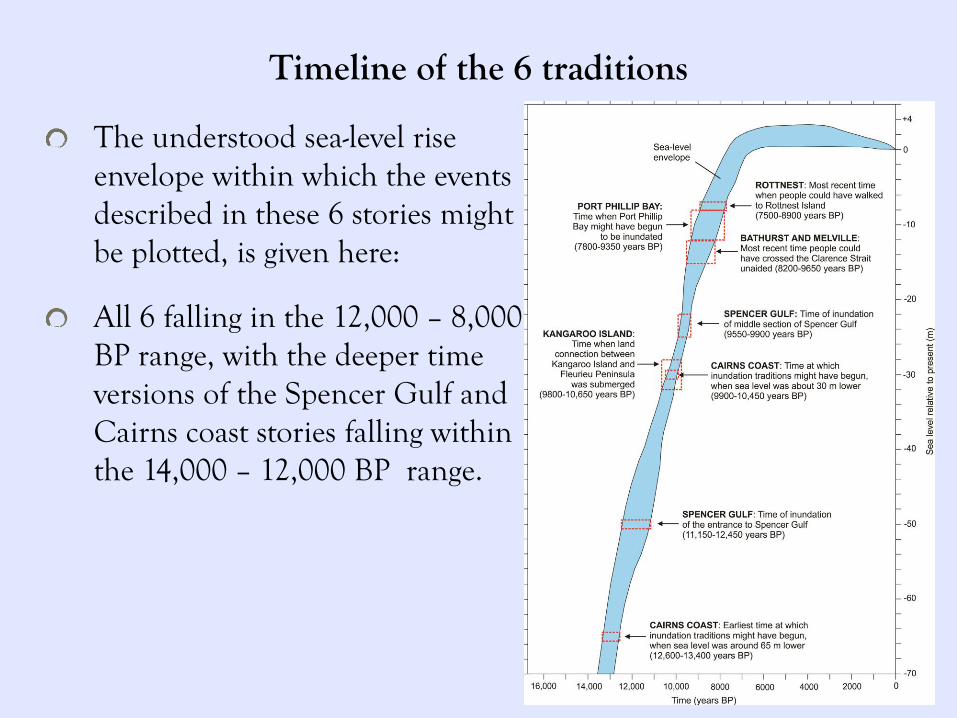
Timeline of the 6 traditions
The understood sea-level rise envelope within which the events described in these 6 stories might be plotted, is given here:
All 6 falling in the 12,000 – 8,000 BP range, with the deeper time versions of the Spencer Gulf and Cairns coast stories falling within the 14,000 – 12,000 BP range.
Setting out the uncertainties
• Imprecise geographical information: “the shore-line was once some miles further out … where the barrier reef now stands” (Dixon, 1980:46)
• Modern bathymetry is not always a reliable guide to past bathymetry: inundation doesn’t just fill a coastline, but erodes it and shifts sediments around.
•About 14% of the stories aren’t directly attributed to specific Aboriginal people: despite Clunies Ross’s confidence, we can’t rule out recorder bias or non-Indigenous innovation in a small number of cases.

Setting out the uncertainties
•Another uncertainty is the potential for stories to be 'read back into the landscape', where geographical features might obviously suggest an event that might then be recounted as though witnessed.
There are such cases with meteorites, where observed meteors become linked through story with meteor-strike craters, but those craters turn out to be hundreds of thousands of years old, predating human occupation (Hamacher 2014).
With respect to sea level changes, this seems to be a more likely problem where sea levels fall, exposing visible evidence of a previous submarine environment, rather than sea level rise which does not. Given the complexities of any coastline, it is not clear that any environment would be retrospectively read as 'breached or inundated' in the absence of any actual sea level change.
Consistency of theme
The 6 stories touched on here, and the fuller set of 21, all point in a remarkably uniform way to sea-level changes that occurred in the few thousand years preceding the sea level high of 7,000 years BP.
Two compelling measures of their authenticity:
1. They come from all around the Australian coast
2. There is a general lack of stories involving sea levels dropping and exposing land that was once under the sea.
While there is understandably some uncertainty about the likely/possible ages of traditions from particular sites, there seems little doubt that they do actually recall the time when rising postglacial sea-level attained the level of the continental shelf locally and rapidly inundated coastal lowlands.
How sceptical should we be?
The lack of any systematic analysis of these traditions, may be due to the scepticism with which most scientists might instinctively regard the attribution of scientific credibility to oral traditions that date back several thousand years. That scepticism still runs deep.
“It is one thing to use folklore and oral tradition as a means of ascertaining or demonstrating what the members of an ethnic group believe (or once believed) about the world and their collective past. It is another thing entirely to use folklore and oral tradition as proof of the truth of what the group believes. As a general rule, folklore and oral tradition are not stable enough to be taken as inherently accurate witnesses of events from the remote past… As a general rule, unwritten legends that refer to events more than 1,000 years in the past contain little, if any, historical truth…” (Simic, 2002)
Reappraising scepticism
The extraordinary care with which Aboriginal people have passed down these stories over previously unimaginable time depths forces a rethink of the ways in which such oral traditions have previously been dismissed.
While these examples should not be regarded as a licence for the incautious interpretation of the antiquity of oral traditions, or indeed for the belief all such stories have empirical foundations, it does allow for some traditions in some cultures to have survived far longer than it was once thought any such traditions could.
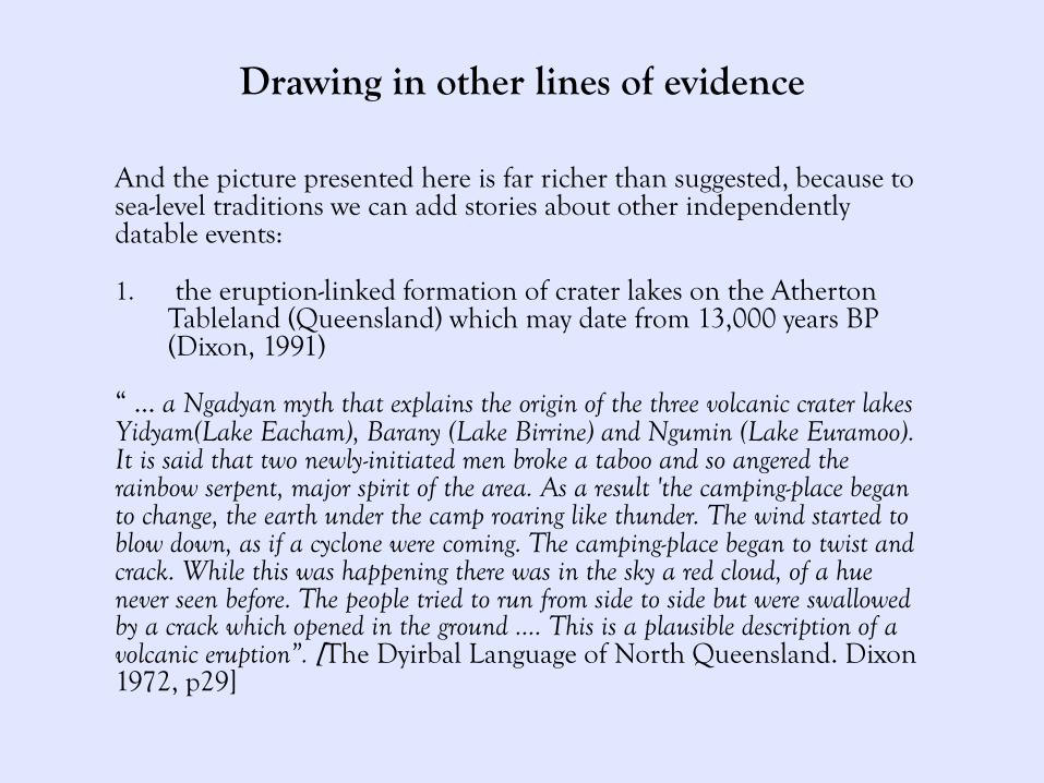
Drawing in other lines of evidence
And the picture presented here is far richer than suggested, because to sea-level traditions we can add stories about other independently datable events:
1. the eruption-linked formation of crater lakes on the Atherton Tableland (Queensland) which may date from 13,000 years BP (Dixon, 1991)
“ … a Ngadyan myth that explains the origin of the three volcanic crater lakes Yidyam(Lake Eacham), Barany (Lake Birrine) and Ngumin (Lake Euramoo). It is said that two newly-initiated men broke a taboo and so angered the rainbow serpent, major spirit of the area. As a result 'the camping-place began to change, the earth under the camp roaring like thunder. The wind started to blow down, as if a cyclone were coming. The camping-place began to twist and crack. While this was happening there was in the sky a red cloud, of a hue never seen before. The people tried to run from side to side but were swallowed by a crack which opened in the ground …. This is a plausible description of a volcanic eruption”. [The Dyirbal Language of North Queensland. Dixon 1972, p29]
Drawing in other lines of evidence And the picture presented here is far richer than suggested, because to sea-level traditions we can add stories about other independently datable events:
2. After telling the previous Ngadyan myth the storyteller explained that “when this happened the country around the lakes was 'not jungle - just open scrub'. In 1968, a dated pollen diagram from the organic sediments of Lake Euramoo by Peter Kershaw [1970] showed, rather surprisingly, that the rain forest in that area is only about 7,600 years old”. . [The Dyirbal Language of North Queensland. Dixon 1972, p29]
3. the eruption of Mt Gambier (South Australia) 4,300–4,600 years BP (Smith, 1880; Sutherland, 1995)
4. Aboriginal oral traditions about encounters with extinct megafauna several thousand years ago (Flood, 1989; Vickers-Rich & Archbold, 1991; Sharpe & Tunbridge, 1997).
5. Aboriginal oral traditions about meteorites (Duane Hamacher, Finding meteorite impacts in Aboriginal oral tradition at 4,700 years BP, http://theconversation.com/finding-meteorite-impacts-in-aboriginal-oral-tradition-38052) 04.03.2015

Cultural continuity
The concept of cultural continuity is a hotly contested arena: back to Kennewick man (US), and native title claims (Australia).
“If human remains are found on federal lands and their cultural affiliation to a Native American tribe can be established, the affiliated tribe may claim them. The Umatilla tribe requested custody of the remains, wanting to bury them according to tribal tradition. Their claim was contested by researchers hoping to study the remains. The Umatilla argued that their oral history goes back 10,000 years and say that their people have been present on their historical territory since the dawn of time, so a government statement that Kennewick Man is not Native American is detrimental to their religious beliefs”. [http://en.wikipedia.org/wiki/Kennewick_Man]
The Australian canon of sea-level rise stories speaks of careful unbroken transmission of cultural information across (perhaps 400-500?) generations. Indeed continuity so strong that it survived seismic linguistic shifts…
Cultural continuity: Implications for the PamaNyungan expansion?
The spread of Pama-Nyungan languages, which we believe happened around 4,000 yrs BPish:
If we accept that these stories originate from the pre-7000 yrs BP period, it follows that they must have originally been told in nonPama-Nyungan languages, and then come to be told in PN.
This may be the first direct evidence we have that, whatever the mechanism, nonPN -> PN linguistic change in Australia was of a type that left cultural transmission intact.
The uniqueness of this canon
Australian Aboriginal people's wealth of such deep time-depth stories stands out as exceptional among the corpus of such traditions globally.
What kind of cultural attributes might have fostered the accurate carrying of information in this way? 1. The practice and nature of Aboriginal storytelling, particularly
the ways in which it was ritually embedded in cultural practice, and the explicit teaching of 'Law', the deliberate ‘owner-manager’ tracking of teaching responsibilities, coupled with high evaluation of unchangedness as a doctrinal principle, which encouraged the learning and onward transmission of particular traditions by successive generations (Berndt & Berndt, 1989).
2. ‘Conservation over deep time is achieved by inter-generational transmission processes that maximize precision of replication. These formalized strategies are built on a necessary foundation of human language and culture, the potential for inter-generational replication fidelity’ (Rose, 2006).
3. The comparative isolation of Australia compared with other continents.
The uniqueness of this canon
We’ve sourced Aboriginal stories about coastal drowning from 21 locations in mainland Australia that we think likely recall the effects of postglacial sea-level rise more than 7000 years ago. Given earlier views on the probable longevity of oral traditions, which doubt they could be sustained in recognisable form more than 500-800 years, this conclusion is somewhat radical, even allowing for its mentions by earlier authors (Dixon 1980, Sharpe & Tunbridge 1999) and the possibility that at least one oral tradition from elsewhere in the world might be of comparable age (Deur 2002).
In a global context, this raises the possibility that stories of comparable antiquity both in Australia and elsewhere in the world exist and may yield information that is likewise of interest and significance to a range of questions. Yet more parochially, the fact that stories with a similar narrative are known from 21 locations in Australia raises the possibilities that both more details/versions of these stories are known and that comparable unreported stories referring to other places in Australia also exist. Given the range of current threats to oral traditions, globally as well as in Aboriginal Australia, it would seem to be a priority to rediscover these stories, given that those presented in this paper may be some of earliest extant human memories.

The full set of 21 traditions
Spencer Gulf Cape Don
Kangaroo Island Bathurst & Melville Islands
MacDonnell Bay Brue Reef
Gippsland Rottnest, Carnac & Garden Islands
Botany Bay Cape Chatham
Moreton & Stradbroke Islands Oyster Harbour
Hinchinbrook & Palm Islands Bremer Bay
Cairns – Great Barrier Reef Nullabour near Eucla
Wellesley Islands Fowler’s Bay
Elcho Island Port Phillip Bay
Goulburn Islands [email protected]
Acknowledgement •
I acknowledge joint authorship of the wider research project with my colleague:
Patrick D. Nunn
Sustainability Research Centre,
University of the Sunshine Coast,
Queensland 4556, Australia
Email: [email protected]