ABM RESOURCES NL CONCEPTUAL MINE CLOSURE PLAN
88
ABM RESOURCES NL CONCEPTUAL MINE CLOSURE PLAN TWIN BONANZA PROJECT / MINE SITE
Transcript of ABM RESOURCES NL CONCEPTUAL MINE CLOSURE PLAN

ABM RESOURCES NL CONCEPTUAL MINE CLOSURE PLAN TWIN BONANZA PROJECT / MINE SITE

TABLE OF CONTENTS 1. Scope and purpose ..................................................................................................................................................... 1 2. Project overview ........................................................................................................................................................ 1 3. Identification of closure obligations and commitments ............................................................................................ 7
3.1 Legal obligations register ....................................................................................................................................... 7
4. Collection and analysis of closure data .................................................................................................................... 11 4.1 Regional environment ......................................................................................................................................... 12
4.1.1 Topography, geomorphology and vegetation ...................................................................................................... 12
4.1.2 Climate ................................................................................................................................................................. 14
4.1.3 Topsoil and subsoil ............................................................................................................................................... 15
4.1.4 Geology ................................................................................................................................................................ 16
4.1.5 Groundwater and surface water .......................................................................................................................... 16
4.2 Environment of the Twin Bonanza mine site ....................................................................................................... 17
4.2.1 Topography and geology ...................................................................................................................................... 17
4.2.2 Topsoil and subsoil ............................................................................................................................................... 19
4.2.3 Hydrology ............................................................................................................................................................. 19
4.2.4 Hydrogeology ....................................................................................................................................................... 20
4.2.5 Flora and fauna studies ........................................................................................................................................ 21
4.3 Social-economic environment ............................................................................................................................. 23
4.3.1 Historical, Aboriginal and heritage sites ............................................................................................................... 24
4.3.2 Current land use ................................................................................................................................................... 24
4.4 Other .................................................................................................................................................................... 24
4.4.1 Design and construction of waste dumps and tailings dams ............................................................................... 24
4.4.2 Volumes of key rehabilitation materials .............................................................................................................. 25
4.4.3 Learnings from closure experience from other mines ......................................................................................... 26
5. Rehabilitation of the Twin Bonanza mine site ......................................................................................................... 26 5.1 General ................................................................................................................................................................ 28
5.2 Processing plant ................................................................................................................................................... 29
5.3 Accommodation village ....................................................................................................................................... 30
5.4 Workshop areas and hydrocarbon storage areas (including explosive magazine).............................................. 30
5.5 Airstrip ................................................................................................................................................................. 30
5.6 Haul and access roads (including roads to water bores and firebreaks) ............................................................. 31
5.7 Bores and pipelines.............................................................................................................................................. 31
5.8 Pits ....................................................................................................................................................................... 32
5.9 Water storage dam .............................................................................................................................................. 32
5.10 Tailings dams ....................................................................................................................................................... 35
5.11 Concentrate residual dam ................................................................................................................................... 36

5.12 Waste rock dumps. .............................................................................................................................................. 39
5.13 ROM areas and low grade stockpile .................................................................................................................... 42
5.14 Borrow pit ............................................................................................................................................................ 42
6. Rehabilitation materials balance ............................................................................................................................. 42 7. Analysis of data / knowledge gaps ........................................................................................................................... 46 8. Stakeholder consultation ......................................................................................................................................... 47 9. Post-mining land use and closure objectives ........................................................................................................... 48
9.1 Post-mining land use ........................................................................................................................................... 48
9.2 Closure objectives ................................................................................................................................................ 49
9.2.1 Compliance .......................................................................................................................................................... 49
9.2.2 Infrastructure and rubbish clean-up .................................................................................................................... 50
9.2.3 Physical safety ...................................................................................................................................................... 50
9.2.4 Stability of landforms and landscape (including visual amenity) ......................................................................... 50
9.2.5 Revegetated or otherwise improved ................................................................................................................... 51
9.2.6 Low risk to biota ................................................................................................................................................... 51
10. Identification and management of closure issues ................................................................................................... 51 11. Development of completion criteria ........................................................................................................................ 57 12. Financial provisioning for closure ............................................................................................................................ 60 13. Closure implementation .......................................................................................................................................... 62
13.1 Research, investigation and trials ........................................................................................................................ 62
13.2 Progressive rehabilitation .................................................................................................................................... 62
13.3 Unexpected closure or temporary closure .......................................................................................................... 62
13.4 Decommissioning ................................................................................................................................................. 63
14. Closure monitoring and maintenance...................................................................................................................... 63 14.1 EFA monitoring .................................................................................................................................................... 64
14.2 Erosion monitoring .............................................................................................................................................. 65
14.3 Surface water and groundwater monitoring ....................................................................................................... 65
14.4 Rehabilitation/compliance audit ......................................................................................................................... 66
15. Management of information and data .................................................................................................................... 66 16. References ............................................................................................................................................................... 67 17. CONTROL AND REVISION HISTORY .......................................................................................................................... 68
17.1 Document information ........................................................................................................................................ 68
17.2 Revisions .............................................................................................................................................................. 68
17.3 Read by ................................................................................................................................................................ 68
Appendix A: Preliminary Groundwater Resource Assessment – Earth Systems ................................................................... 69 Appendix B: Waste Characterisation ..................................................................................................................................... 70 Appendix C: Tailings Characterisation ................................................................................................................................... 71 Appendix D: Geochemical Review (tailings and waste materials) – Soilwater Group .......................................................... 72 Appendix E: Erosion and Soil Testing – Soilwater Group ...................................................................................................... 73 Appendix F:Old Pirate Groundwater Memo ......................................................................................................................... 74 Appendix G: EcOz Early Dry Season Flora and Fauna Report 2013 ....................................................................................... 75

Appendix H: 4DG Tailings Storage Facility Conceptual Geotechnical Design report ............................................................. 76 Appendix I: Erosion and Sediment Control Plan ................................................................................................................... 77 Appendix J: Letter from CLC regarding rehabilitation of Water Dam ................................................................................... 78 Appendix K: CSIRO EFA monitoring datasheets .................................................................................................................... 79 Appendix M: CSIRO rill assessment data sheet ..................................................................................................................... 82 Appendix N: Preliminary Example of a Rehabilitation/Compliance Audit datasheet ........................................................... 83
LIST OF FIGURES
Figure 1.Project location map. ............................................................................................................................... 2 Figure 2. Site plan of the Twin Bonanza mine site. ................................................................................................ 8 Figure 3. Map of all disturbed areas at Twin Bonanza project within ML 29822 ................................................... 9 Figure 4. Topography close to Old Pirate. ........................................................................................................... 14 Figure 5. Summary of weather from Rabbit Flat weather station ........................................................................ 15 Figure 6. Speed rose of wind direction versus wind speed in km/h at Rabbit Flat .............................................. 16 Figure 7. Location of trunk and major palaeochannels in bedrock ...................................................................... 17 Figure 8. 3D view of water table - Old Pirate……………………………… .. ………………………………………...20 Figure 9. Long section of water table (looking from the east towards Old Pirate…………………………………21 Figure 10. Closure domains for Twin Bonanza project…………………………………… .. ………………………..26 Figure 11. Schematic of rehabilitated water storage dam……………………………… .. ………………………….31 Figure 12. Cross-section of rehabilitated water storage dam…………………………… . …………………………32 Figure 13. Cross-section of concentrate residual dam (CRD) design…………………… .. ……………………….35 Figure 14. Northern waste rock dump cross-section……………………………………… ... ……………………….37 Figure 15. Southern waste rock dump cross-section……………………………………… .. ……………………….38 Figure 16. Risk assessment management matrix fo rthe assessment of potential issues for closure of Twin
Bonanza………………………………………………………………………………………………………..48 Figure 17. Development of a completion criteria framework………………………………… .. …………………….53 Figure 18. The bank and trough system characteristic of a newly rehabilitated landscape…… .. ……………….59
LIST OF TABLES Table 1. Legal obligations register for Twin Bonanza mine ................................................................................... 7 Table 2. Rehabilitation materials balance ............................................................................................................ 43 Table 3. Knowledge gaps ..................................................................................................................................... 46 Table 4. Stakeholder consultation register ........................................................................................................... 48 Table 5. : Assessment of potential issues for closure of the Twin Bonanza and management strategies to reduce potential risks. .......................................................................................................................................... 54 Table 6. Completion criteria for closure of the Twin Bonanza project. ................................................................ 58 Table 7. Closure activities of the Twin Bonanza mine ......................................................................................... 60

Page 1 of 84 Conceptual Mine Closure Plan Status: Active Effective: 05/12/2013 Twin Bonanza Project Version: 1.0 Review: 05/12/2014
1. Scope and purpose
The Conceptual Mine Closure Plan (CMCP) for the Twin Bonanza mine site (within ML 29822 and the Section 19 areas granted under the Aboriginal Land Rights(Northern Territory) Act 1976 (Cth) owned by ABM Resources NL (ABM) is being submitted as a requirement of the Environmental Impact Statement (EIS) under the Environmental Assessment Act 1982 (NT) . The purpose of the CMCP is to:
• provide an overview of the Twin Bonanza mine site
• identify the closure obligations and commitments (determined in conjunction with relevant stakeholders)
• describe the proposed post-mining land use and closure objectives
• develop completion criteria for closure of the Twin Bonanza mine site
• document the method of financial provisioning for mine closure
• describe how the CMCP will be implemented at the Twin Bonanza mine site
• describe monitoring and maintenance programs of the Twin Bonanza mine site.
ABM in the course of establishing this CMCP has followed the principles and objectives identified in the Strategic Framework for Mine Closure (ANZMEC, 2000). In addition, the following documents were also used to guide the development of the methodology for the delivery of the project:
1. Leading Practice Sustainable Development in Mining Handbooks
a. A Guide to Leading Practice Sustainable Development in Mining
b. Evaluating Performance: Monitoring and Auditing
c. Mine Closure and Completion
d. Mine Rehabilitation
e. Risk Management
f. Tailings Management
2. Planning for Integrated Mine Closure: Toolkit (ICMM 2008)
3. Guidelines for Preparing Mine Closure Plans (Department of Mines and Petroleum Western Australia/EPA, 2011).
4. Mine Close out Objectives, Life of Mine Planning Objectives, Advisory Note (Department of Mines and Energy 2008)
2. Project overview
The Twin Bonanza mine site (located on ML 29822) and the approved Section 19 areas are held by ABM which operates from a Head Office located at Level 1, 141 Broadway Nedlands Western

Page 2 of 84
Conceptual Mine Closure Plan Status: Active Effective: 05/12/2013 Twin Bonanza Project Version: 1.0 Review: 05/12/2014
Australia 6009. The Twin Bonanza mine site is located approximately 625km NW of Alice Springs (Figure 1) and approximately 16km east of the Northern Territory and Western Australian border. The site is located approximately 33km south of the Tanami Road, which runs North West from Alice Springs to the Northern Territory and Western Australian border (Figure 1).
Figure 1.Project location map.
The Twin Bonanza Mineral Lease is still under application.
The Twin Bonanza gold project is a major asset of ABM and is one of the last known surficial out-cropping gold deposits in Australia that has not been mined. ABM has spent in excess of $14 million on this ground since acquiring the Twin Bonanza tenement from Newmont Asia Pacific (Newmont) in March 2010.
Since acquisition ABM has completed a number of close spaced drilling programs along with extensive surface sampling which has led to a maiden resource at the Old Pirate deposit within the Twin Bonanza project area in April 2012. The April 2012 JORC Compliant Resource estimation for the Old Pirate deposit was completed in April 2012 and was updated in the first quarter of 2013.

Page 3 of 84
Conceptual Mine Closure Plan Status: Active Effective: 05/12/2013 Twin Bonanza Project Version: 1.0 Review: 05/12/2014
In 2013, a 10,000 tonne bulk sample of ore is being excavated for onsite testing to evaluate the variations in ore grade and metallurgic characteristics. The infrastructure onsite for the bulk sample includes a fully lined below ground tailings/water storage dam, processing plant, small accommodation camp and pits along the ore body.
The Twin Bonanza project is currently at an approval stage. In the initial stage ABM seeks approval for an open pit mining operation of 140,000-240,000 tonnes of ore per annum over an initial pit life of 3-4 years. The scope of this conceptual closure plan is to cover the initial open pit mining stage. If economically viable potential underground mining of the deposit will follow. However for this to occur further approvals are to be sought and the closure plan updated to reflect the next stages of the project. For the proposed 3-4 year operation infrastructure will include the establishment of:
• open cut pits to access the ore body
• a crushing circuit, gravity separation circuit including a Knelson concentrator
• a small Acacia cyanide reactor for selective leaching of small ore samples
• power generating facilities
• bulk fuel storage and refueling bay
• storage of processed material in the tailings dam
• storage of processed gravity concentrate and lab tailings material in a small tailings dam
• storage of waste rock in a waste rock dump
• a mining camp to accommodate 68 staff
• a water storage dam
• development of workshops and offices (including washdown bays)
• haul roads
• minor modification to existing access roads
• water bores and installation of water pipelines
• potential upgrade of the existing airstrip.
Processing of ore will primarily involve crushing, milling and gravity separation to concentrate ore minerals containing gold. Groundwater will be used in gravity separation techniques with minimal chemicals or hazardous materials being used in the process. A total area of 223.3 ha will be disturbed above the existing bulk sample and exploration disturbance of 32.5 ha. The disturbed areas of the Twin Bonanza mine site are detailed in Figure 2.
Twin Bonanza project covers Buccaneer and Old Pirate deposits. Initial mining is to be focused at the Old Pirate deposit. The Buccaneer area has the potential to provide materials (including clay) that

Page 4 of 84
Conceptual Mine Closure Plan Status: Active Effective: 05/12/2013 Twin Bonanza Project Version: 1.0 Review: 05/12/2014
may be required in the construction of the infrastructure to mine and process the Old Pirate deposit and surrounding prospects. At a later stage, once Buccaneer has undergone further assessment an additional proposal to facilitate the mining and processing of Buccaneer may be submitted.

Page 5 of 84
Conceptual Mine Closure Plan Status: Active Effective: 05/12/2013 Twin Bonanza Project Version: 1.0 Review: 05/12/2014
Figure 2: Site plan of the Twin Bonanza mine site

Page 6 of 84
Conceptual Mine Closure Plan Status: Active Effective: 05/12/2013 Twin Bonanza Project Version: 1.0 Review: 05/12/2014
Figure 3: Map of all disturbed areas at Twin Bonanza project within ML 29822. Left: Disturbed areas prior to mining, including bulk sample infrastructure. Right: Proposed disturbance area for mining.

Page 7 of 84
Conceptual Mine Closure Plan Status: Active Effective: 05/12/2013 Twin Bonanza Project Version: 1.0 Review: 05/12/2014
3. Identification of closure obligations and commitments
3.1 Legal obligations register
The Twin Bonanza environmental commitments and conditions will be finalised once the assessment of the project is complete and all commitments are acceptable under the EIS and subsequent Mining Management Plan (MMP). ABM will comply with the legal requirements both of the Northern Territory and the Commonwealth of Australia.
In addition, a mining agreement has been negotiated with Traditional Owners and environmental commitments have been set under the agreement as facilitated through the Central Land Council (CLC). The mining agreement details ABM’s environmental commitments made to protect Traditional Owners and traditional land use. The details of the mining agreement with the Traditional Owners are confidential and cannot be disclosed in this document. However, ABM can state that it has had open and honest dialogue with the Traditional Owners and this conceptual closure plan attempts to reflect the environmental terms and conditions of the agreement. Additionally, the Central Land Council has negotiated an agreement to protect the land and provide strong economic benefits to the Traditional Owners.
Accordingly, the overall objective of closure is to create stable final landforms, returning as much of the project area as practicable to a similar landscape and ecosystem to what was the pre-existing land use.
The rehabilitation strategy will remain flexible and can be amended as operations evolve, new rehabilitation techniques are developed, and environmental investigations progress.
As the project is under permitting only the commitments in the closure plan have been added to the legal obligations register, however ABM will fill in the legal obligations register for all other approval commitments (Table 1) as the application progresses. Internally a legal obligations register has been established that currently contains the confidential commitments.
Table 1. Legal obligations register for Twin Bonanza mine
Twin Bonanza mine
CLOSURE PLAN
Page No. Closure Commitment
Section 7 Over the life of the project it is intended to undertake further geochemical testing to refine the current geochemical understanding
Section 4.4.1 Formation of a low permeability layer in the tailings dam to limit seepage
Section 4.4.1 The outer tailings dam and concentrate residual embankments designed with 14 degree (1(V):4(V)) walls to limit erosion.

Page 8 of 84
Conceptual Mine Closure Plan Status: Active Effective: 05/12/2013 Twin Bonanza Project Version: 1.0 Review: 05/12/2014
Twin Bonanza mine
CLOSURE PLAN
Page No. Closure Commitment
Section 4.4.1, 5.10, 5.11 At closure the capping of the tailings dam and concentrate residual dam with a 1.6m store and release cover to limit water egress into the tailings.
Section 4.4.1, 5.12 Encapsulating physical and geochemically adverse material within the waste dump to limit erosion and potential for chemical reactions
Section 4.4.1, 5.12 Design of the outer batters to 15 degrees as determined by modelling and testing of the competent and inert sandstone to be used on the external of the waste dump.
Section 4.4.1, 5.12 Designing the top of the waste dump to be water harvesting to prevent water cascading from the top surface down the outer slopes and outer batters to prevent water shedding.
Section 4.4.2
Top 800 to 1000mm of the transported pisolite/gravelly profile across the pits will be selectively handled and used as part of the tailings dam and top surface of the waste rock dump capping layer to create a soil profile similar to the surrounding environs.
Section 4.4.2 Rehabilitation materials (pisolite/gravel, siltstone and sandstone) to be stockpiled in close proximity to their intended end use.
Section 4.4.2 Where practicable rehabilitation will be implemented progressively.
Section 5.1 Prior to topsoil recovery, if present vegetation will be cleared and stored in windrows.
Section 5.1 Top soil stripping will involve the top 100mm of material.
Section 5.1 The topsoil will be stored in stockpiles no greater than 2m high proximal to disturbance areas for future use in rehabilitation and decommissioning.
Section 5.1 All dams will be filled in order to prevent feral animals from using these areas as water sources.
Section 5.1 Closure of tailings dam will adhere to the closure principles outlined in the ANCOLD Guidelines on Tailings Dams 2012.
Section 5.1 Water diversion structures left at closure will be designed in consideration of a 1:1000yr peak flow event.
Section 5.1
At closure the project area will be surveyed by an accredited auditor to ascertain the presence and extend of any contamination. If any areas are identify a plan will be put in place to remove this material and if possible treat on site or dispose of appropriately in accordance to the current legislative requirements and in agreement with the relevant regulators.
Section 5.2 Where practicable steel will be recycled and removed from site.
Section 5.2 Once the plant has been removed any residual ore or spilt tailings material will be graded into windrows and placed in the tailings dam.
Section 5.2 Flat areas will be re-contoured into the surrounding landscape, ripped and covered with topsoil to ensure water infiltration, establish a soil profile and vegetation.
Section 5.3
Once the camp has been removed any below ground services (i.e. electrical cabling) within 0.5 metre of the surface are to be removed, other deeper services will be cut 0.5 metre below the ground surface and backfilled.

Page 9 of 84
Conceptual Mine Closure Plan Status: Active Effective: 05/12/2013 Twin Bonanza Project Version: 1.0 Review: 05/12/2014
Twin Bonanza mine
CLOSURE PLAN
Page No. Closure Commitment
Section 5.3 Any ponds, landfills and below ground septic systems will be decommissioned and backfilled.
Section 5.3 Once ripping has been completed any cabling, pipework of other camp items that have been bought to the surface will be collected for disposal.
Section 5.7
If not transferred to Traditional Owners both groundwater and monitoring bores will be decommissioned in accordance to the Departments of Mines and Energy advisory note titled “Construction and Rehabilitation of Exploration Drill Sites” and the document titled “Minimum Construction Requirements for Water Bores in Australian, Edition 3”.
Section 5.7
If Traditional Owners request that a track or road remain open then ABM will ensure that the road or track is left in a suitable condition with the width of the road reduced where practicable to reflect the ongoing purpose of the road.
Section 5.8
An abandonment bund will be constructed around the perimeter of the pit void (In accordance to the current Western Australia guideline titled Safety Bund Walls Around Abandoned Open Pit Mines (DOIR 1997)).
Section 5.8 Potential backfilling of the pits will be evaluated by ABM to reduce the operations footprint and manage waste rock and/or tailings.
Section 5.11
Dense tailings concentrate that has undergone cyanide leaching will report to the concentrate residual dam. Leached tailings will have the cyanide removed prior to deposition. As a conservative measure the material will not be deposited in the larger tails dam rather it will be managed in the concentrate residual dam that will be lined.
Section 5.13
If practicable, low grade stockpiles will be processed with the majority of the material reporting to the tailings dam. However, if this is not possible the southern end of the northern waste dump will be used to encapsulate the material.
Section 7 Establish onsite rehabilitation trials.
Section 8 Stakeholder engagement will be an ongoing process during the life of the operation.
Section 9
• Achieve compatibility with agreed post-mining land use. • Ensure the health and well-being of people and fauna. • Remove all infrastructure and any removable non
mining wastes from the site. • Create safe, stable, non-polluting and sustainable
landforms. • Achieve successful rehabilitation and demonstrate a
return of ecosystem functions. • Ensure establishment of vegetation that is self-
sustaining, including the integration into the predicted fire regime.
• Undertake progressive rehabilitation of available disturbed areas.
• Maintain water quality and flows. • Minimise long-term visual impact by creating

Page 10 of 84
Conceptual Mine Closure Plan Status: Active Effective: 05/12/2013 Twin Bonanza Project Version: 1.0 Review: 05/12/2014
Twin Bonanza mine
CLOSURE PLAN
Page No. Closure Commitment
acceptable landforms, compatible with the adjacent landscape.
Section 12 Ensure resourcing and the provision of adequate funds for closure.
Section 13 Continual development and review of mine closure plan.
Section 13.2 Where practical undertake progressive rehabilitation of the Twin Bonanza mine site.
Section 13.3 Care and maintenance plan that will be updated as the project develops.
Section 14.4 Following all the rehabilitation work a rehabilitation/compliance audit will be conducted. The audit will focus on identifying any areas where rehabilitation requirements have not been met.
ENVIRONMENTAL PROTECTION AND BIODIVERSITY ACT 1999 :
Condition No. Date Aspect related to closure
Mining Agreement with Traditional Owners
Tenement Closure Commitments (Confidential only used internally)
NOI/Mining Management Plan
Page No. Closure Commitment
EIS (NT EPA)
Page No. Closure Commitment
Non-legally binding commitments and promises ( letters, references, records and documents)
Documents Name – No.

Page 11 of 84
Conceptual Mine Closure Plan Status: Active Effective: 05/12/2013 Twin Bonanza Project Version: 1.0 Review: 05/12/2014
Twin Bonanza mine
CLOSURE PLAN
Page No. Closure Commitment
Page No. Closure Commitment
Environmental commitments associated with the CLC through mining agreement and Section 19 leases
Mining and lease agreements have been formulated between ABM and the CLC for the purposes of meeting the criteria of the mineral lease grant and to secure land tenure over areas that contain support infrastructure (i.e. airstrip and borefield). The intent of the agreements is to advance and respect the interest of both parties and properly manage the environmental impacts. To this end a number of environment commitments have been made, the details of which are confidential (refer to section 3.1).
ABM will comply with the commitments made under the mining agreement before, during and after operations. As the terms and conditions of the agreements for mining and support infrastructure align with good mining industry practice
4. Collection and analysis of closure data
Data presented throughout this CMCP is based on existing information available from applicable site studies and investigations, legislative and policy needs. This data and information has been collected:
• using recognised and accepted industry methodologies and standards
• incorporating appropriate quality assurance testing and data management
• considering the interaction between the receiving environment, receptors and the exposure pathways.
This section provides an overview of data relevant to the closure of the site.

Page 12 of 84
Conceptual Mine Closure Plan Status: Active Effective: 05/12/2013 Twin Bonanza Project Version: 1.0 Review: 05/12/2014
4.1 Regional environment
4.1.1 Topography, geomorphology and vegetation
The majority of the area is dominated by various thicknesses of colluvial cover, the depth of which is greatest within palaeodrainage systems. Hills and ridges are common in the northern and central parts of the region and range in height from less than 30m to more than 200m above the surrounding plains. They are often steeply incised by narrow channels and creeks, which pass into outwash fans before disappearing into the surrounding sand plains. Topography of the area is outlined in Figure 4.
Vegetation is generally sparse, because of the arid climate and predominantly sandy soils, and consists mainly of spinifex with scattered low trees (mostly species of eucalyptus and acacia), shrubs and herbaceous plants. Few trees are taller than 8m with relatively large trees present only along creeks. There are no permanent watercourses in the region; however water can persist in seasonal flow paths for at least a few months following seasonal rains.

Page 13 of 84
Conceptual Mine Closure Plan Status: Active Effective: 05/12/2013 Twin Bonanza Project Version: 1.0 Review: 05/12/2014
Figure 4. Topography close to Old Pirate.

Page 14 of 84
Conceptual Mine Closure Plan Status: Active Effective: 05/12/2013 Twin Bonanza Project Version: 1.0 Review: 05/12/2014
4.1.2 Climate
The Tanami region has a typical Northern Australian climate with most of the average 290mm of annual rainfall occurring during a ‘wet season’ between November and April. The summers are hot with temperatures in excess of 40ºC and winters are usually mild although nights are cold with occasional overnight minimum temperatures below 0 ºC. The closest weather station is located at Rabbit Flat, less than 90km to the east. Average annual maximum temperature is 33.6 ºC, average annual minimum temperature is 16.6 ºC. Average annual rainfall is 430.7mm.
Figure 5. Summary of weather from Rabbit Flat weather station

Page 15 of 84
Conceptual Mine Closure Plan Status: Active Effective: 05/12/2013 Twin Bonanza Project Version: 1.0 Review: 05/12/2014
Average pan evaporation for this region is between 2400 and 2800mm per annum, far exceeding the average rainfall (BOM, 2012).
Winds are calm year round, particularly during the dry season and generally in an easterly direction, tending northeast during the wet season (Figure 6). Wind speeds average 14.9km/hour in the morning to 15.5km/hour in the afternoon (BOM, 2012).
Figure 6. Speed rose of wind direction versus wind speed in km/h (15 Nov 1996 to 30 Sep 2010) at Rabbit Flat. Rabbit Flat is the nearest weather station with most accurate weather observations for the Twin Bonanza project (National Climate Centre of the Bureau of Meteorology, 2012).
4.1.3 Topsoil and subsoil
The project occurs within the Tanami sand plains region, characteristics include sand plain with minor longitudinal dunes in the south, floodplains and floodouts on the margins. The geomorphology generally consists of saprock (>50%), colluvial sediments (20-50%) and saprolite (<20%). Broad scale soils are sand, loamy sand or clayey sand (<10%) with a pH of less than 4.3.

Page 16 of 84
Conceptual Mine Closure Plan Status: Active Effective: 05/12/2013 Twin Bonanza Project Version: 1.0 Review: 05/12/2014
4.1.4 Geology
The regional geology of the project is almost exclusively on deep marine turbidite sediments, of the Dead Bullock Group and Killi Killi formations (Boucher, 2011), and punctuated by the Buccaneer Monzogranite to the northwest of the project area. To the east, the turbidites are contained in a geological formation known as the Dead Bullock Group. Air-photo interpretations and field mapping show none of the formations outcrop. The Dead Bullock Formation in the region is distinguished from the Killi Killi Formation by a significantly elevated magnetic response.
4.1.5 Groundwater and surface water
The water table is generally between 90 –150m with an average of around 100m over the deposit area, this varies due to changing rock types and fractures. Earth Systems conducted a desktop survey of the groundwater resources for ABM, in June 2013 (Earth Systems 2013 -Appendix A). The initial environmental study identified that the surface water flows are intermittent and cannot supply the site’s water needs but this study has identified two potential groundwater sources that may be suitable. These are hard rock fractured bedrock aquifers and unconsolidated sedimentary aquifers hosted within tertiary to recent palaeochannels.
Surficial deposits of aeolian sand, alluvial sand/silt/clay, gravel, calcrete, silcrete and minor evaporite are widespread and form relatively thick sequences in the Cenozoic-filled palaeodrainage network that are located to the east and west of the project area. Palaeochannels are considered to be unconfined with variable depths to water of 3-6m in calcrete aquifers and 5-10m in alluvial systems (seasonally variable).
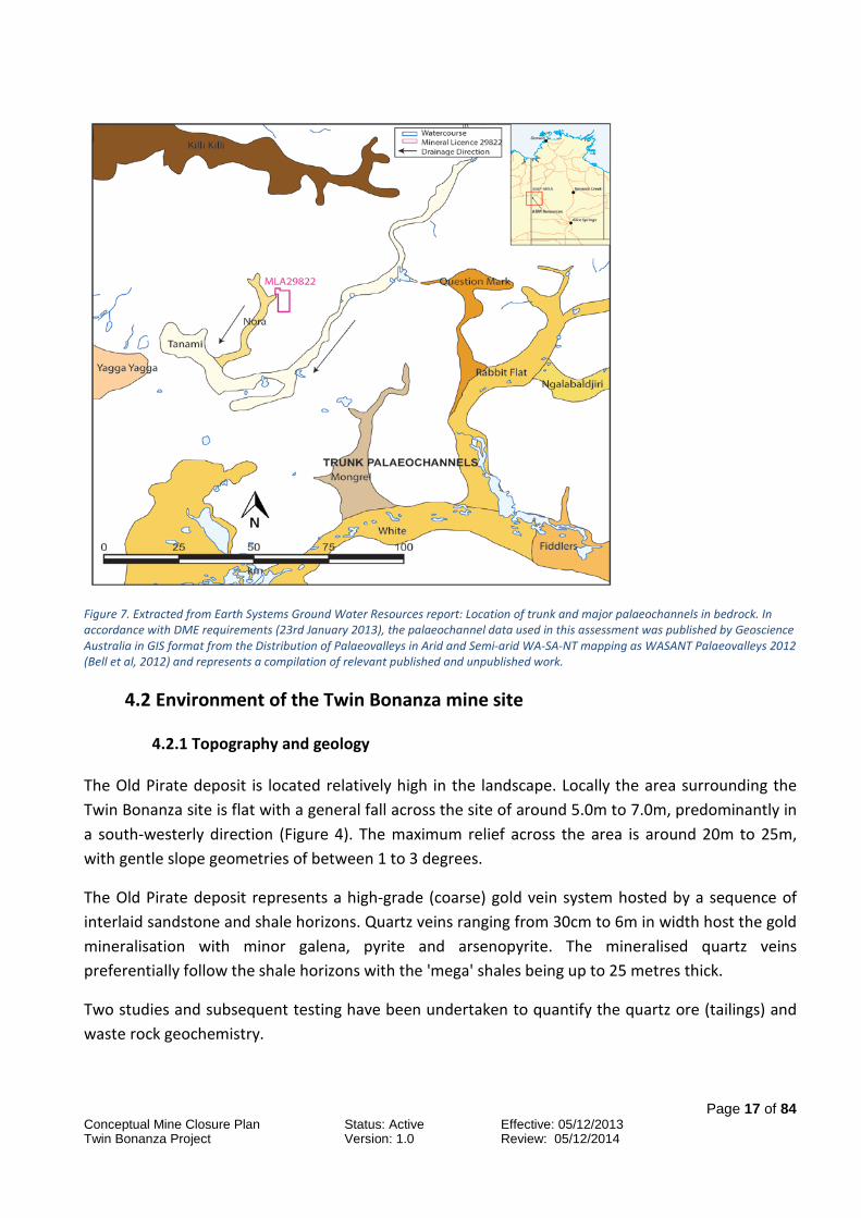
The Cenozoic palaeodrainage system in the Tanami region forms a network of topographic depressions with broad trunk palaeochannels and narrow higher-order palaeochannels, with evidence for significant tectonic disruption and diversion. Domahidy (1990) identified two large Cenozoic palaeochannels (hereafter referred to as palaeochannels) in the region, one west-trending and the other south-trending, which converge between Rabbit Flat and Tanami Downs and then head southwards towards Lake Mackay, incorporating additional tributaries on the way. Detailed mapping by Wilford (2000) identified and delineated an extensive and higher-order palaeodrainage network using surface flow modeling. These palaeochannels have been interpreted by Bell et al (2012).
The location of the main palaeochannels is shown in Figure 7. Two main channels are present to the east and west of the Twin Bonanza project and are respectively known as Tanami and Nora.
Page 17 of 84
Conceptual Mine Closure Plan Status: Active Effective: 05/12/2013 Twin Bonanza Project Version: 1.0 Review: 05/12/2014
Figure 7. Extracted from Earth Systems Ground Water Resources report: Location of trunk and major palaeochannels in bedrock. In accordance with DME requirements (23rd January 2013), the palaeochannel data used in this assessment was published by Geoscience Australia in GIS format from the Distribution of Palaeovalleys in Arid and Semi-arid WA-SA-NT mapping as WASANT Palaeovalleys 2012 (Bell et al, 2012) and represents a compilation of relevant published and unpublished work.
4.2 Environment of the Twin Bonanza mine site
4.2.1 Topography and geology
The Old Pirate deposit is located relatively high in the landscape. Locally the area surrounding the Twin Bonanza site is flat with a general fall across the site of around 5.0m to 7.0m, predominantly in a south-westerly direction (Figure 4). The maximum relief across the area is around 20m to 25m, with gentle slope geometries of between 1 to 3 degrees.
The Old Pirate deposit represents a high-grade (coarse) gold vein system hosted by a sequence of interlaid sandstone and shale horizons. Quartz veins ranging from 30cm to 6m in width host the gold mineralisation with minor galena, pyrite and arsenopyrite. The mineralised quartz veins preferentially follow the shale horizons with the 'mega' shales being up to 25 metres thick.
Two studies and subsequent testing have been undertaken to quantify the quartz ore (tailings) and waste rock geochemistry.

Page 18 of 84
Conceptual Mine Closure Plan Status: Active Effective: 05/12/2013 Twin Bonanza Project Version: 1.0 Review: 05/12/2014
The area surrounding the Old Pirate deposit is naturally anomalous in arsenic and lead; Old Pirate was discovered as a result of the local arsenic anomalism and contains multiple narrow high grade veins which don’t tend to outcrop as well as the bucky exposed and barren quartz in the region. Local arsenic values vary from <10 ppm to <4000 ppm in soil and rock chip samples. Rock samples and soil samples around Old Pirate report readings in excess of 1ppm Bismuth (natural crustal abundance 0.17ppm) and an average of 1.5ppm Uranium (average crustal abundance 2.7 ppm).
Tailings produced during operations will contain minor volumes of pyrite, galena and arsenopyrite with the samples having a low potential to produce acid mine drainage. Some tailings samples are elevated in arsenic and lead due to the presence of galena and arsenopyrite.
Geological logging of the waste rock has defined three lithological units that can be detailed as siltstone, sandstone and, intercalated sandstone and siltstone. The units have varying degrees of oxidation down to 60 metres. Within the units pyrite and arsenopyrite occur along veins with decreasing sulphides away from the ore body (EIS Appendix L: ABM Tailings Characterisation). Acid Based Accounting and Net Acid Generation indicated the units are unlikely to generate acid mine and metalliferous drainage.
Elemental enrichment of arsenic is present in the oxidised units and in close proximity to the mineralised quartz ore. The arsenic enriched zone close to the mineralised quartz veins contains various amounts of quartz, pyrite and arsenopyrite, and has the potential to contain recoverable gold. Due to the presence of arsenic, the altered material that occurs in a 5 metre halo has been classified as a separate unit known as “Intercalated – Anomalous Arsenic” this unit will be selective handled as a low grade ore due to its gold potential. Further detail of waste rock characterisation is contained in the EIS Appendices M: ABM Waste Dump Characterisation and N: Geochemical Review – tailings and waste materials.
Over the life of the project it is intended to undertake further geochemical testing to refine the current geochemical understanding.
Laboratory-scale erosion testing was conducted on a 300kg sample of the proposed sandstone unit to be used on the external batters of the post-mine landforms. A laboratory-scale rainfall simulator was used to measure the interrill (raindrop impact) erodibility (Ki) and effective hydraulic conductivity (Keff) of each material, and a rill erosion test was conducted to measure the rill erodibility (Kr) and critical shear stress (TC) of the materials under overland flow conditions. These parameters were then used within the Watershed Erosion Prediction Project (WEPP) model to determine expected average sediment yields on a range of land surface configurations (refer to Appendix E: Erosion and soil testing).
In general the predicted erosion rates for the unit are low due to the armouring effects of the large rock/gravel fraction and high infiltration rate.

Page 19 of 84
Conceptual Mine Closure Plan Status: Active Effective: 05/12/2013 Twin Bonanza Project Version: 1.0 Review: 05/12/2014
4.2.2 Topsoil and subsoil
To characterise the soils, three surficial soil samples and 8 samples spaced every 10cm from a single soil profile were collected. The three soil samples and profiles samples were analysed for particle size, gravel content, erosion characteristics, pH, electrical conductivity, nutrients and exchangeable cations.
The soil profile is characterised as a shallow sandy loam, consisting of surficial red sandy loam cover (i.e. upper 30 – 50 cm), overlying a partially to completely weathered sandstone (i.e. reflects a saprock or transition material). Plant roots were present throughout the sampled profile. The surficial cover material contains a significant residual gravel fraction (15 – 40 % gravel), with generally fewer gravels present in the underlying weathered transition zone (5 – 25 %). The underlying in situ sandstone is considered to be well cemented, but a high proportion of gravel (55 – 65 %) was measured in the laboratory sample, which is thought to be representative of the properties of this material once broken up during excavation.
The surficial cover material is strongly acidic (pH = 4.0 – 4.9), while the underlying sandstone is moderately alkaline (pH = 8.2 at 135 cm depth). The majority of salts appear to have been leached from the measured profile, and the surface soils are subsequently considered non‐saline and non-sodic. The soils are generally low in nutrients and organic carbon highlighting their low chemical fertility and lack of pedogenic development. Cation exchange capacity of the surface soils was low, with the exchange complex dominated by calcium and magnesium cations. This low CEC implies that kaolinite is the dominant clay mineral, and thus these materials are likely to be macro-structurally unstable, with the individual clay plates wanting to separate and mobilise (Note: this is different from micro-structural dispersion caused by elevated Na levels).
An analysis of dispersion showed that most of the topsoils are potentially dispersive after mechanical disturbance of the soil structure (i.e. after excavation and stockpiling). This classification is mainly attributed to the lack of salts within the soil solution to facilitate aggregation and flocculation of clays. Thus, soils containing the largest fractions of clay (i.e. the weathered “transition” layer) are at the greatest risk of dispersion. Conversely, soils containing larger fractions of gravel will be at the least risk of the effects of dispersion. The topsoils (0 – 30 cm depth) and sandstone (> 100 cm depth) are therefore expected to be the least affected by dispersion because of the moderate clay content and significant gravel content in these soil horizons (Appendix 5).
4.2.3 Hydrology
No permanent surface water is located in the region. Seasonal creeks and ephemeral lakes exist over parts of the project area. The Lake Mackay system in the Western Arunta is the largest lake system in the region.

Page 20 of 84
Conceptual Mine Closure Plan Status: Active Effective: 05/12/2013 Twin Bonanza Project Version: 1.0 Review: 05/12/2014
Where there is topographic relief, seasonal creeks typically drain into lowland lacustrine systems. In low relief sand plain country surface flooding often occurs following heavy rain. This sometimes forms flood ways along low lying drainage channels which drain towards ephemeral lacustrine systems; elsewhere surface water subsequently seeps into porous sandy soils or evaporates.
4.2.4 Hydrogeology
Regional groundwater flows towards low topography associated with palaeochannels. A basic model using recorded drilling data at Old Pirate and surrounds shows the water table clearly. The water table is generally between 90 –150m below ground level with an average of around 100m over the project area, this varies due to changing rock types and fractures (see Figures 9 and 10). From drilling data geological logging and field observation it was concluded that minor amounts of water could be encountered in perched systems, however the bulk of the water would be encountered at depths greater than 100 metres (Appendix F: Old Pirate Groundwater Memo).
Figure 8. 3D view of water table - Old Pirate.

Page 21 of 84
Conceptual Mine Closure Plan Status: Active Effective: 05/12/2013 Twin Bonanza Project Version: 1.0 Review: 05/12/2014
Figure 9. Long section of water table (looking from the east towards Old Pirate).
To accommodate water needs of 11.1 L/s, ABM will seek to utilise bores located within the Mineral Lease and also water resources adjacent to the south western corner of the Mineral Lease where a borefield and connecting pipeline are anticipated. These areas have been secured for access by the grant of an interest in the land pursuant to s.19 of Aboriginal Land Rights (Northern Territory) Act 1976 (ALR Act) by the relevant Land Trust. Two large paleochannels encircle the project area; these have been identified as the most logical place to find further water in good quantities if required. Additional bores may need to be established for mining and processing and further hydrological work and assessment will be conducted on the project as the project progresses.
ABM will not take, direct, or use surface water without first notifying all relevant stakeholders. No rivers or creeks will be diverted as part of the project. The proposed pits for the Twin Bonanza project are not expected to intersect groundwater, however ABM will monitor groundwater throughout the life of the mine to mitigate any issues.
4.2.5 Flora and fauna studies
Three flora and fauna surveys covering both dry and wet condition were conducted over the project area between 2012 and 2013 (EIS Appendix C: Early dry season Flora and Fauna Report 2013).
The combined field studies yielded 180 flora species, none of which were classified as threatened under Northern Territory or Commonwealth legislation. Survey findings were supported by a

Page 22 of 84
Conceptual Mine Closure Plan Status: Active Effective: 05/12/2013 Twin Bonanza Project Version: 1.0 Review: 05/12/2014
desktop assessment that indicated it was unlikely that threatened flora species would be supported within the project area.
Surveys identified two flora species endemic to the Tanami Desert (Acacia abbreviata and A. minutifolia) and two species of regional significance due to their restricted ranges in the Northern Territory (Dampiera candicans and Sclerolaena muelleri).
No individuals of the native walnut (Owenia reticulata) (of cultural significance to the local Aboriginal people) were identified in the study area.
Five vegetation types were described within the project area, including:
• Vegetation type 1: Low Eucalyptus brevifolia isolated trees ± mid high Acacia lysiphloia or low A. hilliana isolated shrubs over Triodia basedowii open hummock grassland; occurs on rocky outcropping.
• Vegetation type 2: Triodia basedowii and T. intermedia mid open hummock grassland with Acacia minutifolia and A. adoxa var. adoxa low open shrubland; occurs on gravel flat to gentle relief.
• Vegetation type 3: Open Triodia spp. hummock grassland ± low Eucalyptus brevifolia or Hakea lorea isolated trees with tall ± Grevillea wickhamii or Acacia spp. open shrubland; occurs in sand plains.
• Vegetation type 4: Low Corymbia opaca or Eucalyptus victrix ± Eucalyptus brevifolia open woodland with tall Acacia sericophylla open shrubland over Triodia pungens open hummock grassland; occurs in palaeochannels.
• Vegetation type 5: Acacia aneura woodland over mixed tussock grass; occurs within a variety of landform, however always present on heavy soils with high clay content.
No threatened ecological communities were identified by desktop review or on ground studies. Vegetation condition within the project area was described as largely intact native vegetation, with only minor impacts from fire and weeds.
Two weed species are known to be present in the general area, including buffel grass (Pennisetum (Cenchrus) ciliaris) and purple-top Chloris (Chloris barbata), both of which were recorded in the vicinity of ‘Wilson’s Camp and bore’. Buffel grass has been identified as a species capable of changing ecosystems by modifying fire regimes. It is likely that these weeds can be controlled as they only occur in an isolated patch and ABM has been active in recent times with local eradication efforts. The on-going control of weeds will be carried out by ABM. The palaeodrainage channels were highlighted as a sensitive habitat type, as palaeochannels in the Tanami Desert are known to support a high level of biodiversity (including threatened species refuge).

Page 23 of 84
Conceptual Mine Closure Plan Status: Active Effective: 05/12/2013 Twin Bonanza Project Version: 1.0 Review: 05/12/2014
The three fauna survey results for the project area generated a total of 112 species, including 30 reptiles, 58 birds and 24 mammals. Two of the recorded species are threatened under Northern Territory and Commonwealth legislation and will require specific management measures:
• Brush-tailed mulgara (Dasycercus blythi) – vulnerable under the Territory Parks and Wildlife Conservation Act.
• Greater bilby (Macrotis lagotis) – vulnerable under the Territory Parks and Wildlife Conservation Act and Environment Protection and Biodiversity Conservation Act 1999.
The desktop assessment indicated that an additional threatened fauna species may be supported in habitat types within the project area (but were not identified during surveys) this species was:
• Great desert skink (Liopholis kintorei).
The crest-tailed mulgara (Dasycercus cristicauda) was highlighted as potentially present however further investigations of distribution, ecology, and known records discounted this species as a potential to occur within the project area. Reasons for confusion are associated with this species and D. blythi which have only recently been split into separate species.
Two introduced species, feral cat (Felis catus) and one-humped camel (Camelus dromedarius), were recorded during the fauna survey. ‘Predation by feral cats’ is listed as a key threatening process under the EPBC Act due to the role of cats in the decline of several species of native fauna in the arid zone, including the greater bilby. One-humped camels are likely to impact vegetation and wetlands.
4.3 Social-economic environment
The project area is located on Aboriginal freehold land (Mt Frederick No. 2 Aboriginal Land Trust). ABM updates its digital data from the Aboriginal Areas Protection Authority (AAPA) to ensure any recorded sites are included within the Tanami-Arunta GIS database. Details and locations of heritage sites are also obtained from the Northern Territory Heritage Register website for inclusion within the database.
The CLC conducts anthropological/cultural heritage surveys across the project area based on the impact/intensity of planned activities, the CLC subsequently notifies ABM of any “sacred sites” that are within or nearby a work area. These sacred sites are of significant cultural importance and are to remain confidential. Under the provisions of both deeds for exploration and mining agreement, should any areas of possible Aboriginal significance be found which are not recorded, ABM is required to avoid disturbing the feature and advise the CLC of the nature / location of the site.

Page 24 of 84
Conceptual Mine Closure Plan Status: Active Effective: 05/12/2013 Twin Bonanza Project Version: 1.0 Review: 05/12/2014
4.3.1 Historical, Aboriginal and heritage sites
Two recent sacred site clearances were performed within EL28322 which includes the area of the current bulk sample and proposed mine. All sacred sites were identified clearly by qualified anthropologists, with none being present in the project work area.
Public circulation of sacred site information is forbidden under agreements with the CLC. If this information is required the government departments must consult directly with the CLC.
An archaeological survey across the proposed mine area highlighted the presence of six archaeological sites in proximity to the mine area; it is proposed that these sites will be avoided during operations or if disturbance is required further approvals will be sought.
4.3.2 Current land use
All of project falls under Aboriginal Land (Mount Fredrick Land Trust No. 2) and is held as inalienable freehold title under the ALR Act. Aboriginal rights and interests in land are also recognised under the Native Title Act 1993 (Cth). The Native Title Act gives Aboriginal people the right to negotiate in regard to ‘future acts’ on their land and the ALR Act gives Aboriginal people a right of veto for mining projects.
ABM recognises and respects the rights of the Traditional Owners and before any activity is carried out on-ground consults with and submits work programs to the CLC for sacred site clearances and their approval. Environmental documents including this one, the EIS and Mining Management Plans are first sent to the CLC for their overview and instruction. The CLC has been made aware of our intention to carry out mining upon completion of the bulk sample and the mining agreement is already in place.
4.4 Other
4.4.1 Design and construction of waste dumps and tailings dams
Design of the tailings dams and waste rock dumps are documented in Appendix H. The design of both landforms is to ensure they are safe, stable and non-polluting, thus enabling integration into the ecosystem and future land use. Measures adopted to achieve this outcome for the tailings dam are:
• Formation of a low permeability layer in the tailings dam to limit seepage.
• Operation of the decant pond in the centre of tailings dam to limit seepage through the embankments.
• Geochemical testing of the tailings material indicates that it has a limited potential to create acid mine drainage.

Page 25 of 84
Conceptual Mine Closure Plan Status: Active Effective: 05/12/2013 Twin Bonanza Project Version: 1.0 Review: 05/12/2014
• Monitoring and if required water recovery along structural influences.
• The outer embankments designed with 14 degree (1(V):4(V)) walls to limit erosion.
• Separation of tails into two dams—
o residual cyanide leached material for the lined evaporative dam (referred to as the concentrate residual dam); cyanide removed prior to deposition
o standard tailings (no cyanide) standard treatment as discussed above with standard lining.
• At closure the capping of the tailings dam with a store and release cover to limit water egress into the tailings.
• Locating the facility on a mineralised soil with a similar geochemical signature (i.e. elevated in arsenic) to the tailings to reduce the effect of the tailings.
The following measures are to be adopted for the waste rock dumps:
• Characterisation of the waste rock units using drilling data, petrology, visual observations, geochemical and erosion testing.
• Encapsulating physical and geochemically adverse material within the waste dump to limit erosion and potential for chemical reactions.
• Design of the outer batters determined by modelling and testing of the competent and inert sandstone to be used on the external of the waste dump.
• Designing the top of the waste dump to be water harvesting to prevent water cascading from the top surface down the outer slopes and outer batters to prevent water shedding.
• Locating the waste dump on a mineralised soil with a similar geochemical signature (i.e. elevated in arsenic) to the most enriched waste rock units to minimise the geochemical contrast.
4.4.2 Volumes of key rehabilitation materials
A comparison between the required rehabilitation volumes and the recovered topsoil, subsoil and inert competent waste (Section 6) has highlighted sufficient material will be available. In addition, the top 800 to 1000mm of the transported gravelly profile across the pits will be selectively handled and used as part of the tailings dam and top surface of the waste rock dump capping layer to create a soil profile similar to the surrounding environs. Rehabilitation materials are to be stockpiled in close proximity to their intended end use to reduce rehandling at closure and where practicable this rehabilitation will be implemented progressively.

Page 26 of 84
Conceptual Mine Closure Plan Status: Active Effective: 05/12/2013 Twin Bonanza Project Version: 1.0 Review: 05/12/2014
4.4.3 Learnings from closure experience from other mines
During operations ABM intends to visit other mine sites in the Tanami Region to observe the success of rehabilitation efforts in the region and where applicable apply those findings to refine the proposed rehabilitation strategies. Additionally the continuing evolution of closure literature and regulatory guidance will help provide further learning opportunities to the site.
The environment of the Twin Bonanza mine site post mining will be discussed below. The nature of the operations and the progression of the project will determine the final environment of the mine site, however as the project is being run with a staged approach there is the potential to reduce environmental impact if at any stage the project becomes no longer feasible and the mine is closed prematurely.
5. Rehabilitation of the Twin Bonanza mine site
For the purposes of rehabilitation, the Twin Bonanza site has been divided into a number of rehabilitation domains that represent separate mining features which require differing rehabilitation treatments. A list of the closure domains are as follows with details of each proposed rehabilitation domain outlined in the following sections. The location of each domain is illustrated in Figure 10.
• waste rock dumps
• tailings dam
• concentrate residual dam
• water storage dam
• pits
• processing plant
• ROM areas and low grade stockpile
• borrow pit
• haul and access roads
• accommodation village
• workshop areas and hydrocarbon areas (including explosive magazine)
• bores and pipelines
• airstrip

Page 27 of 84
Conceptual Mine Closure Plan Status: Active Effective: 05/12/2013 Twin Bonanza Project Version: 1.0 Review: 05/12/2014
Figure 10. Closure domains for Twin Bonanza project. Left: Mine site closure domains within ML 2982. Right: Airstrip closure domain within the Section 19 lease.

Page 28 of 84
Conceptual Mine Closure Plan Status: Active Effective: 05/12/2013 Twin Bonanza Project Version: 1.0 Review: 05/12/2014
5.1 General
All historical exploration (including costeans, sumps, access tracks, drill pads etc.) will be filled to the natural surface (where necessary) and ripped. All rubbish/wastes will be removed from site and/or disposed of appropriately on site. Closure planning is an evolving process, the management and rehabilitation treatments for each domain will be updated due to further stakeholder consultation and as more information becomes available.
Clearing will be undertaken progressively to reduce the effects of soil degradation and erosion. The vegetation material may be retained for fauna habitat and later rehabilitation.
Depending on its constituents, topsoil can serve a number of important functions, such as (DITR 2006):
• the supply of seed and other propagules
• contribution of beneficial micro-organisms
• supply of natural nutrients
• rapid development of groundcover
• amelioration of adverse constituents in the underlying mine waste.
Where possible, the timing of topsoil removal would be coordinated with rehabilitation operations to ensure minimal handling and storage. In general, this method helps ensure that the reserve of indigenous plant seeds and soil microflora are maintained and assist with the preservation of local genetic material and the reestablishment of a similar range and mix of species to that of the original vegetation in rehabilitation areas.
ABM is committed to retaining the topsoil as a viable resource to use for rehabilitation purposes at a later date. Topsoil stripping will involve the top 100mm of material. The topsoil will be stored in stockpiles no greater than 2m high proximal to disturbance areas for future use in rehabilitation and decommissioning. Designated topsoil stockpiling areas will be prepared to minimise topsoil losses (Figure 3). Topsoil stockpiling heights and storage time will be minimised as deterioration of soil chemical, physical and biological properties can occur during storage. Topsoil stockpile areas will be signposted to prevent inadvertent use.
The total area to be cleared over the life of the project is 255.8 hectares. This total includes topsoil and rehabilitation material stockpiles.
Progressive rehabilitation will be undertaken during the life of the mine, to optimise topsoil properties. Topsoil stockpiles that are retained for longer periods will be paddock dumped to increase the surface to volume ratio to encourage natural re-vegetation.

Page 29 of 84
Conceptual Mine Closure Plan Status: Active Effective: 05/12/2013 Twin Bonanza Project Version: 1.0 Review: 05/12/2014
Areas contoured back to original ground level will be covered by 100mm of topsoil. Areas above grade including the waste dump and tailings storage will have 100mm of topsoil covering the top surface of the landforms and the outer batters will have a rock mulch consisting of blended topsoil and inert sandstone. If required, areas will be seeded with locally collected material with the aid of traditional owners. Once rehabilitated, areas will have signage and access will be restricted with bunds to prevent disturbance to the rehabilitation.
Inert stockpiles on site will be flattened and spread across the surface of cleared areas to integrate with natural surfaces of surrounding slopes. In the case of the tailings dam the closure principles outlined in the ANCOLD Guidelines on Tailings Dams 2012 will be adhered to. Due to the small scale catchments any water diversion structures left at closure will be designed in consideration of a 1:1000yr peak flow event (Appendix I: Erosion and Sediment Control Plan).
Prior to decommissioning unused chemicals, hydrocarbons and explosives are to be removed from site. At closure the project area will be surveyed by an accredited auditor to ascertain the presence and extend of any contamination. If any areas are identify a plan will be put in place to remove this material and if possible treat on site or dispose of appropriately in accordance to the current legislative requirements and in agreement with the relevant regulators.
5.2 Processing plant
The processing plant will cover a total area of 2.8 hectares and consists of stockpile area, crusher, ball mill, Knelson concentrators, Acacia Reactor and associated conveyors. Prior to decommissioning the processing circuit will be emptied of any reagents and fluids. ABM proposes to either retain the plant for future projects within the region, on sell the plant or commission a demolition/salvage company to dismantle the processing plant and associated steel work. Where practicable this material will be recycled and removed from site. When there are no other options uncontaminated and inert material such as concrete will be encapsulated in the waste dump or placed in a purpose approved costean. Any disposal on site will ensure that:
• the disposed material does not compromise the rehabilitation of any other domains e.g. waste dump
• material will be crushed and compacted to minimize void space to thus prevent subsidence of the disposal area.
Once the plant has been removed any residual ore or spilt tailings material will be graded into windrows and placed in the tailings dam. The area will then be re-contoured into the surrounding landscape, ripped and covered with topsoil to ensure water infiltration, establish a soil profile and vegetation.

Page 30 of 84
Conceptual Mine Closure Plan Status: Active Effective: 05/12/2013 Twin Bonanza Project Version: 1.0 Review: 05/12/2014
5.3 Accommodation village
The accommodation village will cover a total area of 8.8 hectares and consists of a car park, workshop, accommodation units, dry mess, offices, landfill and sewage system. It is proposed to retain the accommodation village for relocation to future projects in the region, sell or donate the dongas and transportable buildings to external parties, or commission a demolition/salvage company to dismantle the village and associated infrastructure. Where practicable this material will be recycled and removed from site. When there are no other options uncontaminated and inert material will be encapsulated in a purpose approved costean. Any disposal on site will ensure that material will be crushed and compacted to minimize void space to prevent subsidence of the disposal area.
Once the camp has been removed any below ground services (i.e. electrical cabling) within 0.5 metre of the surface are to be removed, other deeper services will be cut 0.5 metre below the ground surface and backfilled. Any ponds, landfills and below ground septic systems will be decommissioned and backfilled. The area will then be re-contoured into the surrounding landscape, ripped and covered with topsoil to ensure water infiltration, establish a soil profile and vegetation. Once ripping has been completed any cabling, pipework of other camp items that have been bought to the surface will be collected for disposal.
5.4 Workshop areas and hydrocarbon storage areas (including explosive magazine)
The workshop and hydrocarbon areas will total 2.3 hectares and consists of vehicle workshops, fuel storage, offices and wash down areas and explosive magazine (explosive magazine to be located in another area as per legislation). The bulk hydrocarbon and chemical tanks will be emptied, decommissioned and transported off site. It is proposed the workshop will be dismantled and removed with all machinery removed from site. If uncontaminated and inert material cannot be removed from site, this material will be buried in a purpose approved costean. Any disposal on site will ensure that material will be crushed and compacted to minimize void space to prevent subsidence of the disposal area. If hydrocarbon contaminated soils are present in the area the material will be collected and bioremediated on site prior to disposal.
Once the workshop and hydrocarbon storage tanks have been removed and the hydrocarbon soils have been collected. The area will then be re-contoured into the surrounding landscape, ripped and covered with topsoil to ensure water infiltration, establish a soil profile and vegetation.
5.5 Airstrip
The airstrip and associated infrastructure will total an area of 18.8 hectares and consist of a runway, parking apron, windsock and sun shelter. With the airstrip being used by a number of different

Page 31 of 84
Conceptual Mine Closure Plan Status: Active Effective: 05/12/2013 Twin Bonanza Project Version: 1.0 Review: 05/12/2014
exploration companies over the years, ABM will explore the option of leaving the airstrip for use by future parties. If this is not an option all cones, the wind sock and shelter will be removed. During the decommissioning the Civil Aviation Safety Authority will be notified the airstrip has been decommissioned and can no longer be used. The surface will be contoured and ripped with available topsoil placed over the surface. As the airstrip covers a large area and is located on a slope ripping will be along the slope contour to minimize erosion.
5.6 Haul and access roads (including roads to water bores and firebreaks)
The haul and access roads will total 7.8 hectares. Haul roads are unsealed with a maximum width of 21 metres while unsealed access roads will range in size from 5 to 10 metres wide. The current access road provides entry into the region for the Traditional Owners to undertake land management and traditional practices. During consultation with the CLC confirmation will be sought as to whether the access road and any other roads will remain after closure. In the short term the access road and a number of internal roads will be kept open to allow access for closure monitoring. If Traditional Owners request that a track or road remain open then ABM will ensure that the road or track is left in a suitable condition with the width of the road reduced where practicable to reflect the ongoing purpose of the road.
Rehabilitation of roads will involve windrows being pulled back across the road with natural drainage patterns being re-established, where possible. The compacted surface will be ripped to ensure water infiltration.
5.7 Bores and pipelines
The groundwater bores and pipelines will cover a total area of 1.9 hectares. Pipelines will consist of PVC pipe. At closure the pipelines will either be rolled up for removal off site or cut into sections to be shredded for recycling or left if requested by Traditional Owners. If required pipeline routes will be ripped to breakup compacted areas that may have formed during the movement of vehicles along the pipeline. Groundwater and monitoring bores will be rehabilitated if they are not transferred to the traditional owners or a third party. Rehabilitation of the bore holes will encompass:
• the removal of pumping infrastructure
• the permanent plugging of the holes below surface
• reshaping the surface, topsoil placement and ripping of any compacted areas.
Both groundwater and monitoring bores will be decommissioned in accordance to the Departments of Mines and Energy advisory note titled “Construction and Rehabilitation of Exploration Drill Sites” and the document titled “Minimum Construction Requirements for Water Bores in Australian, Edition 3”.

Page 32 of 84
Conceptual Mine Closure Plan Status: Active Effective: 05/12/2013 Twin Bonanza Project Version: 1.0 Review: 05/12/2014
5.8 Pits
The pits will cover a total area of 22.6 hectares. When the mine closes the pit will be left. During seasonal rainfall events the pit will partially fill with direct rainfall and limited surface water flows. Evaporation during the dry months will minimise the amount of water remaining in the pit prior to the next wet season as the pits will remain above the water table. From exploration drill hole logging the open pit walls will contain minor veins of partially oxidized sulphides. The presence of small quantities of sulphides will have little effect on water quality. In the long term the quality of the water will be affected by evaporation leading to an increase in salinity.
An abandonment bund will be constructed around the perimeter of the pit void (in accordance to the current Western Australia guideline titled Safety Bund Walls Around Abandoned Open Pit Mines (DOIR 1997)). The establishment of the bund is to make safe the pit by minimising inadvertent access after closure. Bund construction will consist of end tipping suitable waste material to form a two metre height barrier. In order to position the bund outside the potential zone of instability of the pit walls a number of factors need to be considered which include:
• major geological planes of weakness within the pit walls
• rock strength of the pit wall
• variations in rock strength overtime
• pit wall geometry
• the effect of groundwater and incidental rainfall on pit walls
• seismicity
Potential backfilling of the pits will be evaluated by ABM to reduce the operations footprint and manage waste rock and/or tailings. If pits are backfilled fully or partially the infill will be contoured to blend in with the surrounds. However backfilling will not be undertaken if:
• it makes the operation unviable
• it sterilises a potentially viable mineral resource in the future.
• there is a possibility that the safety of future mining operations will be jeopardised.
5.9 Water storage dam
The water storage dam will cover a total area of 1.3 hectares. Prior to being used as a water dam the facility was used for the disposal of tailings during the 2013 Bulk Sampling program. To manage tailings seepage during the trial the facility was lined with a 2mm plastic HDPE liner. At closure approval from the Traditional Owners has been given to leave the plastic liner in situ below the tails. A copy of the CLC approval letters are presented in Appendix J. Key steps for rehabilitation are:

Page 33 of 84
Conceptual Mine Closure Plan Status: Active Effective: 05/12/2013 Twin Bonanza Project Version: 1.0 Review: 05/12/2014
1. Allow suitable time for evaporation.
2. Remove all pipework from the area.
3. Cut away and remove from site all plastic liner above the tails (not required for the leach storage facility).
4. If monitoring of the pond indicates the tailings has the potential to be a source of contamination a 0.5 metre cap of low permeability clay or compacted mine waste will be placed over the tails.
5. Push in the walls to fill the dam to above ground level.
6. Complete contouring of the previously excavated material to leave a 1.3m high elevated pad above the previous water dam location. The pad will be wheel rolled by a front end loader to ensure reasonable, but not excessive, compaction
7. Replace previously stockpiled topsoil.
The elevated pad will ensure that any future subsidence will not leave a depression below ground level. Walls will be sloped to 15 degrees to establish a low angle, low erosion profile.
Figure 11. Schematic of rehabilitated water storage dam.

Page 34 of 84
Conceptual Mine Closure Plan Status: Active Effective: 05/12/2013 Twin Bonanza Project Version: 1.0 Review: 05/12/2014
Figure 12. Cross-section of rehabilitated water storage dam.

Page 35 of 84
Conceptual Mine Closure Plan Status: Active Effective: 05/12/2013 Twin Bonanza Project Version: 1.0 Review: 05/12/2014
5.10 Tailings dams
Tailings reporting to the tailings dam will have only undergone gravity separation and will have had no chemical input. The tailings dam cells will cover a total area of 26.7 hectares. Design, construction operation and closure of the facility will be in accordance ANCOLD 2012 Guidelines on tailings dams. Appendix H contains details on the conceptual design. During construction a layer of 1x10⁻⁸ permeability will be construction within the dams to minimise seepage from the facilities. This layer will either be achieved via conditioning of the insitu material or constructing a clay liner. The aim of rehabilitation activities on the tailings dam will be to stabilise tailings material to significantly reduce the movement of dust, leaching of material into the surrounding environment and to render the tailings dam suitable for colonisation by native vegetation. At decommissioning the tailings pipelines will be will either rolled up for removal off site or cut into sections to be shredded for recycling. Prior to any rehabilitation activities on the tailings facility, the tailings surface will be allowed to dry out. During this period groundwater monitoring will continue to assess the level of seepage from the tailings dam and the associated water quality along the most likely seepage pathways. If required, the monitoring bores are to be designed with the capacity to extract potential seepage. Prospective seepage will most probably be evaporated via the water storage dam. Once dried the decant tower/area will be removed and backfilled with mine waste. A capping layer will be placed on the tailings surface to achieve a store and release cover that acts to minimize moisture influx by maximizing near surface moisture storage allowing for subsequent release by evapotranspiration (MEND 2004): This design has been adopted as the:
• Tanami region is semi-arid with an annual rainfall of 430mm and pan evaporation of between 2400 to 2800mm
• tailings have limited reactivity and are non-acid forming
• basal flow is limited as the facility is high in the catchment and the water table is at least 70 metres below the natural ground level
• soil profiles in the area are characterized by a thin veneer of transported sand and gravel.
A preliminary cover design will have a minimum thickness of 1600mm and will consist of:
• 500mm of run of mine inert course sandstone to provide a capillary break to stop the capillary rise of salts
• 500mm of run of mine inert siltstone to provide a fine layer with a water holding capacity
• 500mm of gravelly subsoil to restore a functioning soil profile (material will be sourced from the 800 to 1000mm of gravelly subsoil excavated from the top of the pits)
• 100mm of topsoil (minimum thickness).

Page 36 of 84
Conceptual Mine Closure Plan Status: Active Effective: 05/12/2013 Twin Bonanza Project Version: 1.0 Review: 05/12/2014
Outer embankment walls of the tailings dam have been designed to have a 14 degree slope (Figure 12), these slopes will be covered by a minimum of 200mm of rock mulch consisting of inert sandstone and topsoil. The rock mulch will be integrated into the underlying embankment. Vegetation across the facility will consist of native grasses and shallow rooted shrubs to stabilise the surface from erosion and reduce the amount of water stored in the cover.
5.11 Concentrate residual dam
The concentrate residual dam will cover a total area of 3.7 hectares. A Knelson concentrator or equivalent will recover an estimated one to two tonnes of dense tailings material daily. This material has the potential to contain fine gold. Dense tailings concentrate that has undergone cyanide leaching will report to the concentrate residual dam. Leached tailings will have the cyanide removed prior to deposition. As a conservative measure the material will not be deposited in the larger tails dam rather it will be managed in the lined concentrate residual dam. Design, construction operation and closure of the facility will be in accordance ANCOLD 2012 Guidelines on tailings dams. Appendix H contains details on the conceptual design. The aim of rehabilitation activities on the concentrate residual dam will be to stabilise tailings material to significantly reduce the movement of dust, leaching of material into the surrounding environment and to render the concentrate residual dam suitable for colonisation by native vegetation. This process will be similar to the tailings dam. At decommissioning the tailings pipelines will be will either rolled up for removal off site or cut into sections to be shredded for recycling. Prior to any rehabilitation activities on the concentrate residual dam, the tailings surface will be allowed to dry out. During operations as only small volumes of tailings are deposited on a daily basis evaporation will aid in tailings consolidation, however if required excess water may need to be removed from the tailings pile. Once dried a capping layer incorporating a water barrier will be placed on the tailings. The capping layer above the barrier will be a store and release cover that acts to minimize moisture influx by maximizing near surface moisture storage allowing for subsequent release by evapotranspiration (MEND 2004). In addition, it is proposed that the landform is water shedding to prevent the accumulation of water in the facility after closure. As this is a conceptual design further research will be undertaken to finalise the most suitable design for long term stability. This design has been adopted as the:
• Tanami region is semi-arid with an annual rainfall of 430mm and pan evaporation of between 2400 to 2800mm
• tailings have limited reactivity and are non-acid forming
• basal flow is limited as the facility is high in the catchment and the water table is at least 70 metres below the natural ground level
• soil profiles in the area are characterised by a thin veneer of transported sand and gravel.
A preliminary cover design will have a minimum thickness of 1600mm and will consist of (Figure 13):

Page 37 of 84
Conceptual Mine Closure Plan Status: Active Effective: 05/12/2013 Twin Bonanza Project Version: 1.0 Review: 05/12/2014
• 500mm of run of mine inert course sandstone to provide a capillary break to stop the capillary rise of salts
• 500mm of run of mine inert siltstone to provide a fine layer with a water holding capacity
• 500mm of gravelly subsoil to restore a functioning soil profile (material will be sourced from the 800 to 1000mm of gravelly subsoil excavated from the top of the pits)
• 100mm of topsoil (minimum thickness).
Outer embankment walls of the concentrate residual dam have been designed to have a 14 degree slope, these slopes will be covered by a minimum of 200mm of rock mulch consisting of inert sandstone and topsoil. The rock mulch will be integrated into the underlying embankment. Vegetation across the facility will consist of native grasses and shallow rooted shrubs to stabilise the surface from erosion and reduce the amount of water stored in the cover.

Page 38 of 84
Conceptual Mine Closure Plan Status: Active Effective: 05/12/2013 Twin Bonanza Project Version: 1.0 Review: 05/12/2014
Figure13. Cross-section of concentrate residual dam (CRD) design.

Page 39 of 84
Conceptual Mine Closure Plan Status: Active Effective: 05/12/2013 Twin Bonanza Project Version: 1.0 Review: 05/12/2014
5.12 Waste rock dumps.
The north and south waste rock dumps will cover a total area of 60.6 hectares and will have final height of 20 and 16.5 metres respectively. A review of the waste material has highlighted that the mined siltstone unit is susceptible to erosion and that some oxidized surface units are elevated in arsenic (Appendix B). These units will be encapsulated in the centre of the waste dump with inert sandstone placed on the external batters (Figures 14 &15). Rainfall will be retained on the top of the dump by creating a concave top surface with a perimeter crest bund. Internally bunds will be constructed across the surface to create compartments that will contain a 1:100 year 72 hour rainfall event.
Erosion testing of 300kg of the oxidized sandstone unit to be used for the external slopes highlighted that external batters would be stable if constructed at ≤18⁰, in light of this batter slopes are proposed to be 15⁰ (Appendix E and I). This is a conservative approach as the oxidized sandstone is more weathered than the transitional sandstone that will also be used on the external slopes of the waste dump. During construction the waste dumps will be continuously assessed to ensure the impact of each waste dump is in harmony with the cultural landscape so that slope angles and height are similar to the natural hills observed in the region. The final waste dump batters will be two lifts of no greater than ten metres height with minimum 10 metre wide back sloping berm between lifts to capture water going down the slopes. Landscape evolution modeling (Appendix E) using the erosion testing results indicated the landform would:
• not contain any concave areas that can concentrate flow into large channels
• be adequate to contain > 100 years’ worth of eroded sediment from the upper portion of the landform
• contain the majority of the sediment on the landform (even though there is evidenced of some accumulation of sediment on the berm after 100 years, but very little gullying is predicted on the lower embankment.)
• be predicted to fill the berms only after >100 years, at which point some overtopping and more gully formation is possible. The model shows severe gullying of both of the waste rock dumps at the end of the 1,000-year model run.
Any remaining subsoil not used for the tailings dams store and release cover will be combined with topsoil and spread across the top surface of the dump.

Page 40 of 84
Conceptual Mine Closure Plan Status: Active Effective: 05/12/2013 Twin Bonanza Project Version: 1.0 Review: 05/12/2014
Figure 14. Northern Waste rock dump cross-section.

Page 41 of 84
Conceptual Mine Closure Plan Status: Active Effective: 05/12/2013 Twin Bonanza Project Version: 1.0 Review: 05/12/2014
Figure 15. Southern Waste rock dump cross-section.

Page 42 of 84
Conceptual Mine Closure Plan Status: Active Effective: 05/12/2013 Twin Bonanza Project Version: 1.0 Review: 05/12/2014
5.13 ROM areas and low grade stockpile
Three ROM areas are to be constructed within the project to manage the differing ore grade stockpiles produced from the various pits. The ROM pads will cover a total area of 4.5 hectares. Once all stockpiles have been removed any residual ore material will be graded into windrows and placed in the tailings dam. The area will then be re-contoured into the surrounding landscape, ripped and covered with topsoil to ensure water infiltration, establish a soil profile and vegetation.
The low grade stockpile will be located either within the ROM pad area or the waste rock dumps. Material contained in the stockpile has a grade of gold that makes it sub-economic in prevailing market conditions. If gold prices increase this material becomes economic to process. If practicable, before closure this material will be processed with the majority of the material reporting to the tailings dam. However, if this is not possible the southern end of the northern waste dump will be used to encapsulate the material. Material will be positioned at least 5 metres from the external batter slopes and top surface of the dump.
5.14 Borrow pit
If required, clay may be sourced from a borrow pit to the north-west of the processing area. The borrow pit will cover a total area of 2 hectares. The depth of the borrow pit will vary depending on the thickness of the clay zone. Once all the required clay has been sourced, the internal batters will be re-contoured to 140 [1(V):4(H)] into the surrounding landscape, ripped and covered with topsoil to ensure water infiltration, establish a soil profile and vegetation. Where practicable the re-contouring will aim to minimize the amount of water that will be stored in the depression.
6. Rehabilitation materials balance
Within section 5 a number of rehabilitation strategies have been detailed, to demonstrate that these strategies can be resourced with the required volumes of rehabilitation materials. Table 2 has been constructed to document the rehabilitation balance:

Page 43 of 84
Conceptual Mine Closure Plan Status: Active Effective: 05/12/2013 Twin Bonanza Project Version: 1.0 Review: 05/12/2014
Table 2. Rehabilitation materials balance
Location Material type Volume Recovered (m3)
Volume required (m3) Comments
Waste rock dump (2 dumps) Topsoil 78671 89549
Tailings dam (2 cells) Topsoil 34632 36049
Water storage dam Topsoil NA NA Direct replacement (existing facility) topsoil recovered
Concentrate residual dam Topsoil 4693 5187
Pits Topsoil 29288 NA Volumes with 130% bulking factor
Expanded processing area (including processing ROM and power plant)
Topsoil 3939 3939 Reuse topsoil available from direct clearing of areas
Haul, access roads and fire breaks Topsoil 6627 6627 Reuse topsoil available from direct clearing of areas
Expanded camp area (including landfill and waste water area) Topsoil 7800 7800 Reuse topsoil available from direct clearing of areas
Workshop areas, offices and hydrocarbon areas Topsoil 2925 2925 Reuse topsoil available from direct clearing of areas
Abandonment bunds and internal area pits Topsoil 34055 34055 Reuse topsoil available from direct clearing of areas
Airstrip Topsoil NA NA Reuse topsoil available from direct clearing of areas
Low grade stockpile Topsoil NA NA If not processed encapsulate in waste dump. Incorporated in ROM and waste rock dump Footprint
Bores and pipelines Topsoil NA NA Reuse topsoil available from direct clearing of areas
Total 202630 186131 Surplus of topsoil

Page 44 of 84
Conceptual Mine Closure Plan Status: Active Effective: 05/12/2013 Twin Bonanza Project Version: 1.0 Review: 05/12/2014
Location Material type Volume Recovered (m3)
Volume required (m3) Comments
Waste rock dump (2 dumps) Subsoil (gravel/pisolite) NA 156640
Only used if material available after capping of dams. Volume required calculated as 400mm layer over top surface of dump (181,773m3 of gravel/pislote material available for constructing soil profile on top surface of waste dump)
Tailings dam (2 cells) Subsoil (gravel/pisolite) NA 102400 Minimum 0.5 metre layer placed over surface. Sourced
from pit area.
Water storage dam Subsoil (gravel/pisolite) NA NA To be backfilled with embankment walls
Concentrate residual Dam Subsoil (gravel/pisolite) NA 8712
Pits Subsoil (gravel/pisolite) 292885 NA Volumes with 130% bulking factor
Total 292885 267752 Surplus of Graval/Pisolite material to restore soil profiles on landform top surfaces
Location Material type Volume Recovered (m3)
Volume Required (m3) Comments
Waste rock dump (2 dumps) Inert sandstone NA 688840
Volume required provides a minimum of 1000mm of inert sandstone covering the whole surface of the dumps. 894048m3 inert sandstone available to encapsulate more adverse material both physical and chemical. Note once mined some of the sandstone units in the intercalated sandstone and siltstone unit may be suitable for use on outer batters.
Tailings dam (2 cells) Inert sandstone NA 102400 Minimum 0.5 metre layer placed over surface. Sourced from pit area (if suitable material defined as sandstone and siltstone intercalated can be used).
Water storage dam Inert sandstone NA NA To be backfilled with embankment walls.
Concentrate residual dam Inert sandstone NA 8712
Pits Inert sandstone 1005160 NA Volumes with 130% bulking factor.
Total 1005160 799952 If suitable sandstone layers defined as intercalated sandstone and siltstone (2744950m3 volumes with 130% bulking factor) can be used for armouring.

Page 45 of 84
Conceptual Mine Closure Plan Status: Active Effective: 05/12/2013 Twin Bonanza Project Version: 1.0 Review: 05/12/2014
Location Material Type Volume Recovered (m3)
Volume Required (m3) Comments
Waste rock dump (2 dumps) Inert siltstone NA NA
Tailings dam (2 cells) Inert siltstone NA 102400 Minimum 0.5 metre layer placed over surface. Sourced from pit area. (if suitable material defined as sandstone and siltstone intercalated can be used)
Water storage dam Inert siltstone NA NA To be backfilled with embankment walls
Concentrate residual dam Inert siltstone NA 8712
Pits Inert siltstone 220090 NA Volumes with 130% bulking factor
Total 220090 111112 Surplus of siltstone to restore soil profiles on landform top surfaces.

Page 46 of 84
Conceptual Mine Closure Plan Status: Active Effective: 05/12/2013 Twin Bonanza Project Version: 1.0 Review: 05/12/2014
As detailed in Table 2 an estimated 202,630m³ of topsoil stockpiled on site will be sufficient for the rehabilitation required. Sufficient subsoil recovered from the pit will be available to provide a minimum layer of 0.5m within the tailings dams cover sequence and provide enough material to form a 0.4m layer over the top of the waste dump. A total volume of 220,000m³ of siltstone is available whereas the tailings dam and concentrate residual dam only requires 111,000m³ to produce the 0.5m required for the cover sequence. The volume of sandstone required for the tailings dam and waste rock dumps is 800,000m³ whereas 1,000,500m³ is available. In addition, once mining has commenced discrete sandstone zones within the intercalated sandstone and siltstone unit may available to be used for the purposes of capping and armoring.
7. Analysis of data / knowledge gaps
The conceptual closure plan has been prepared on the information available at the time of preparation. It is recognised that there are gaps in the knowledge and information available at the conceptual closure planning stage. ABM is committed to systematically expand the knowledge base to improve the expected performance at closure. The current knowledge gaps and proposed actions are detailed in Table 3. In addition, the current closure strategies will be further refined based of ongoing analysis, field observations and monitoring of trials. A failure to close knowledge gaps can result in additional costs, delays in rehabilitation and inability to meet closure objectives. Ongoing collection and analysis of environmental data will adhere to all relevant methodologies and standards with the analysis undertaken by appropriately qualified individuals.
Table 3. Knowledge gaps
Knowledge gap Actions taken to close gap Application of knowledge
Ongoing validation of tailings material.
• Establish 24 month kinetic leach testing.
Modification of the tailings cover.
Vegetation recruitment on rehabilitated slopes.
• Establish onsite rehabilitation trials.
Modify soil treatment and formulate seeding regime.
Potential accumulation of water in the pit.
• Measure volumes within pits over time. • Hydrogeological studies.
Modify closure strategy.
Requirement for seeding. • Establish onsite rehabilitation trials.
Enquire local provenance seeds or commence seed gathering program.
Finalise fully integrated cover design for the concentrate residual dam.
• Review of current practices to closure out lined facilities. • Modelling of water shedding structures.
Improve long term stability.
Ongoing development of completion criteria.
• Establish onsite rehabilitation trials. • Continuing stakeholder engagement including the Traditional Owners.
Improved ability to achieve post mining land use outcomes.

Page 47 of 84
Conceptual Mine Closure Plan Status: Active Effective: 05/12/2013 Twin Bonanza Project Version: 1.0 Review: 05/12/2014
8. Stakeholder consultation
The key external stakeholders of the Twin Bonanza mine site are DME (Northern Territory), EPA (Northern Territory), CLC and Traditional Owners. Each of the key external stakeholders have been consulted during development of the CMCP (Table 4).
The CLC is the body who act on behalf of the Traditional Owners of the land through the ALR Act. The CLC has reviewed this CMCP. For the remaining stakeholders, consultation undertaken for the Environmental Impact Assessment (EIA) process and the Environmental Impact Statement (EIS) document will constitute consultation for the development of the CMCP (Table 4).
Stakeholders include (but are not limited to) the following:
Central Land Council – Traditional Owner Consultation and Regulator of Aboriginal Land
• Government - Department of Mines & Energy – Environmental Regulators, Titles Approvals and Geological Review, Northern Territory Environmental Protection Agency (EPA)
• Australian Government Department of Environment
• ABM employees, contractors and suppliers
• The Central Desert Shire
Consultants and contractors that have contributed to this plan include:
• EnTech - Mining Technical Consultant (scoping study)
• EcOz – Environmental Consultant (flora and fauna)
• Earth Systems - Environmental Consultants (ground and surface water)
• Soilwater Group – Environmental Consultants (erosion testing and modelling)
• 4DG Geotechnical Consultant (tailings storage facility)
• AMETS – Land Tenure Consultant
• Piper Alderman – Legal Consultant
• Mike Slight and Associates – Review of closure plan
Stakeholder engagement will be an ongoing process during the life of the operation. ABM Resources Stakeholder engagement policy is detailed in the Social Impact Management Plan and EIS.

Page 48 of 84
Conceptual Mine Closure Plan Status: Active Effective: 05/12/2013 Twin Bonanza Project Version: 1.0 Review: 05/12/2014
Table 4. Stakeholder consultation register
Date Description of consultation Stakeholders Stakeholder comments/issue
Proponent response and/or
resolution
Stakeholder response
29/07/2013
Geotechnical aspects of waste dumps and tailings
Amanda Jobson DME- Alice Springs
Need to undertake waste and tailings characterisation and demonstrate that the structures/landforms are appropriate for the waste material.
Completed erosion testing and completed conceptual tailings dam design.
09/08/2013 Landscape evolution modeling
Lisa Bradley EPA - Darwin
Referred to DME NA
10/8/2013
Specific details on landscape evolution modeling
Amanda Jobson DME- Alice Springs
DME were consulted regarding landscape evolution modeling and final land use after rehabilitation. DME supported the landscape evolution approach using sampling, erosion testing and subsequent Siberia landscape evolution model to confirm long term erosion potential. Discussed details on appropriate landscape evolution modeling.
Siberia modeling out to 1000 years completed on selected unit.
25/11/2013
Discussion with CLC on specific closure requirements and preliminary feedback on conceptual closure plan
Gary Scott CLC- Alice Springs
Preliminary feedback on draft CMCP. Preliminary comments covered:
• tailings dam design. • surface water
management • monitoring • waste dump construction
Modified draft CMCP to reflect preliminary feedback.
9. Post-mining land use and closure objectives
9.1 Post-mining land use
The Mineral Lease and Section 19 Leases cover an area of 4048.83 ha with the proposed footprint of the mine disturbing 255.8 ha within these leases. Land within the project area is on Aboriginal freehold land (Mt Frederick No. 2 Aboriginal Land Trust) that is used by the Traditional Owners, for traditional purposes, and has more recently been used for mineral exploration purposes. The nearest Traditional Owners’ settlement, Balgo, is 120km to the west of the project area. As mentioned previously natural habitats identified within the tenement and the greater Tanami region include low rises usually covered in lateritic or ferricrete rubble and pediments, minor rock outcropping, with a sandy soil profile with high rock/pebble content. The disturbed area supports rocky outcropping vegetation and gravelly spinifex grassland with acacia shrubland (EcOz, 2013).

Page 49 of 84
Conceptual Mine Closure Plan Status: Active Effective: 05/12/2013 Twin Bonanza Project Version: 1.0 Review: 05/12/2014
As the pre-mining land is for the benefit and activities of the Traditional Owner communities located in the area, conceptual closure strategies have been designed to align the end land use to current land practices:
• Land use for rehabilitation at original ground level – contouring and revegetated for continued traditional owner access and activities.
• Above groundwater dams, waste rock dump and tailings storage facility – stabilised and revegetated above grade rises with limited access for continuation of traditional activities.
The objective for closure of the Twin Bonanza project is to reinstate “natural” ecosystems as similar as possible to the original ecosystem. Ecosystem Function Analysis (EFA), water and erosion monitoring will be used to determine whether rehabilitated landforms in the project area can provide a safe, stable non-polluting and sustainable habitat for flora and fauna within the region.
ABM has developed the following general remediation goals with specific remediation objectives, closure criteria and strategies to address the criteria provided in Table 4. ABM aims to:
• achieve compatibility with agreed post-mining land use
• ensure the health and well-being of people and fauna
• remove all infrastructure and any removable non mining wastes from the site
• create safe, stable, non-polluting and sustainable landforms
• achieve successful rehabilitation and demonstrate a return of ecosystem functions
• ensure establishment of vegetation that is self-sustaining, including the integration into the predicted fire regime
• undertake progressive rehabilitation of available disturbed areas
• maintain water quality and flows
• minimise long-term visual impact by creating acceptable landforms, compatible with the adjacent landscape
• achieve mineral lease relinquishment without a requirement for ongoing active intervention.
9.2 Closure objectives
9.2.1 Compliance
Ensure that the rehabilitation for closure of the Twin Bonanza project is compliant with all commitments and conditions, as specified by the DME and EPA and all legally binding commitments made with the DME and the CLC. These commitments are yet to be finalised/ advised.

Page 50 of 84
Conceptual Mine Closure Plan Status: Active Effective: 05/12/2013 Twin Bonanza Project Version: 1.0 Review: 05/12/2014
Ensure that the closure of the Twin Bonanza project provides a suitable landscape, (comparable to the surrounding natural landscape) to use for traditional Aboriginal land use practices.
Conduct EFA and erosion monitoring of tailings dam and remaining landforms to demonstrate they are safe, stable, non-polluting, sustainable and comparable to the natural landscape.
Conduct rehabilitation/compliance audit of the project to ensure all areas of disturbance have been rehabilitated and legal compliance met.
9.2.2 Infrastructure and rubbish clean-up
During the decommissioning and through closure, wastes and material produced through dismantling will be managed consistent with waste minimisation principles. Rubbish will be either removed from site or disposed of in agreement with relevant regulatory agencies and stakeholders.
Infrastructure will be removed from its location with the only infrastructure to remain on site is that agreed to by regulators and the CLC for the purposes of future use. Infrastructure that is inert and cannot be disposed offsite site will be encapsulated in the waste dump or a purpose built costean (to DME and CLC satisfaction). The location and details of any buried material will be recorded and reported to the DME during the closure process.
All disturbed surfaces will be rehabilitated to facilitate future specified land use.
9.2.3 Physical safety
The rehabilitated landscape and landforms are to be designed to minimize potential harm or injury to employees fauna and the public during and post closure.
Landforms and excavations are made safe to allow ongoing access for post mining land uses.
9.2.4 Stability of landforms and landscape (including visual amenity)
The tailings dam and waste rock dump will be constructed to be safe, stable and non-polluting with any adverse materials encapsulated within the waste rock dump and tailings dam to prevent environmental impacts (as per recommendations made in the geochemical and geotechnical assessments of the tailings and waste rock completed by Soil Water Group, 2013a and 2013b). The constructed waste rock dump and tailings dam will be stable ensuring adequate margin of safety are present and consistent with local topography.
Minor pits, sumps, costeans, below ground excavations and water catchment areas will be filled to prevent environmental impacts including reduction in water availability and attraction of pest species. ABM will ensure that all water catchment areas (including sumps, and costeans) are back

Page 51 of 84
Conceptual Mine Closure Plan Status: Active Effective: 05/12/2013 Twin Bonanza Project Version: 1.0 Review: 05/12/2014
filled to prevent altering surface and groundwater hydrological patterns/flows. The presence of rehabilitated areas shall not alter seasonal water availability.
Any water runoff or seepage from the tailings dam and waste rock dump shall be of a quality compatible with local land and water values. Once rehabilitated and re vegetation in progressing erosion by wind and water will be comparable with the surrounding environs.
Gravel piles will be flattened and spread across the soil surface making rehabilitated areas comparable to the natural landscape.
9.2.5 Revegetated or otherwise improved
Vegetation will be rehabilitated naturally by local seed dispersal and seed germination from seed banks stored in topsoil to ensure similarity in species composition of landforms to the surrounding natural environment. The aim of the re-vegetation will be to re-establish a rehabilitated ecosystem with equivalent functions and resilience to the surrounding ecosystems. This will allow integration into the future land use while enabling recovery after fire events. Progressive rehabilitation, where practicable, will ensure the viability of the soil properties of the stockpiled topsoil ensuring the support of the target ecosystem in rehabilitation.
Landscape function of the landforms will be similar to that of the surrounding natural landscape as determined by EFA monitoring using a natural (analogue) site as reference.
The surface and groundwater levels and quality will reflect background levels and water chemistry.
9.2.6 Low risk to biota
Rehabilitated areas are to have native vegetation and similar landscape to that of the surrounding natural landscape including rocky slopes and drainage areas, providing natural habitat for fauna.
Water quality leaving the tailings dam and waste rock dump shall have similar quality compatible with local land and water values.
Removal of any obstructions (i.e. infrastructure, pipelines etc.) to enable movement of native fauna throughout the landscape.
10. Identification and management of closure issues
Failure to understand and meet the relevant legal requirements and obligations to key stakeholders could result in a failure to meet closure objectives and outcomes. Section 3 identifies the closure obligations with section 5 detailing closure strategies to achieve the desired outcome. This section examines the risk and issues associated with closure.

Page 52 of 84
Conceptual Mine Closure Plan Status: Active Effective: 05/12/2013 Twin Bonanza Project Version: 1.0 Review: 05/12/2014
A full risk assessment has been undertaken for the purposes of the EIS, Table 5 below highlights the issues applicable to closure and the management strategies proposed to be implemented to reduce the potential risks of these issues (assessed using Australian Standard 4360). ABM Resources Environmental Risk Matrix is provided in Figure 16, and outlines the procedure of assessment for potential issues for closure of the Twin Bonanza project. After implementing a number of management actions all closure risks have been reduced, however ABM acknowledges that these risks still require ongoing management at both an operational and corporate level to ensure the final proposed land use can be attained.
The environmental risks associated with mining and processing operations are expected to be minimal due to the minimal amounts of chemicals in processing operations, and the unlikelihood of acid mine drainage (AMD) potential in the ore. The tailings dam which has been geotechnically designed to take into consideration closure is unlikely to be a potential source of chemical contamination of ground or surface water, soil or air quality.
However during operations and at closure the main issues that need to be managed include:
• adverse impacts on surface and groundwater quality
• tailings dam seepage potentially containing elevated arsenic
• dispersive materials from the waste dump
• degradation of bilby and mulgara habit.
To minimise the above issues ABM will need to ensure the proposed closure strategies as outlined in section 9 are implemented with appropriate equipment, suitably experienced personnel and adequate resources.

Page 53 of 84
Conceptual Mine Closure Plan Status: Active Effective: 05/12/2013 Twin Bonanza Project Version: 1.0 Review: 05/12/2014
Figure 16. Risk assessment management matrix for the assessment of potential issues for closure of the Twin Bonanza
Extent of Impact Environmental Species / Biodiversity Health and Safety Business Critical Test
15 19 22 24 25 5 CatastrophicIrrevers ible impact at regional level
Largest envi ronmenta l footprint (>500m²), las ting effects , poor outlook on recovery.
Extinction of species regional ly Fata l i tyLasting Damage to bus iness reputation, > 2 mi l l ion dol lar loss . Operations shut down.
Loss of major portion of cri tica l asset at the regional level
10 14 18 21 23 4 MajorSerious long term impact at regional level
Large environmenta l footprint (<=500m2), long term effects , medium outlook of recovery.
Major loss to s igni ficant species at the loca l level . Dis turbance with long term impact to >50% of individuals in the loca l population
Permanent disabi l i ty Damage to bus iness reputation, <= 2 mi l l ion dol lar loss . Temporary suspens ion of authorization.
Cri tica l asset i s s igni ficantly affected
6 9 13 17 20 3 Moderate
Major but revers ible short term impact. Li ttle/no impact on ecosystem function. Off s i te/regional dis turbance
Large environmenta l footprint (100m2), no las ting effects , good outlook for recovery
A s igni ficant species i s a ffected but not s igni ficantly. Dis turbance, but revers ible, short term impact to <50% of individuals in the loca l population
Medica l treatment and/or impairment, los t time injury > 2 days
Damage to bus iness reputation, > $40k loss . Reduced abi l i ty to operate (s top work).
A cri tica l asset i s a ffected but not s igni ficantly . A high va lue asset i s s igni ficant affected.
3 5 8 12 16 2 MinorMinor revers ible short-term impact at loca l level
Smal l envi ronmenta l footprint (<20m2), area eas i ly rehabi l i tated with no las ting effects .
Smal l number of (<10%) of individuals in the loca l population of non-s igni ficant or s igni ficant species may be affected
Firs t a id treatment lost time injury < 2 days Internal bus iness impacts , <$20k Loss , <2 day delay in operation
A minor affect to a cri tica l or high va lue asset
1 2 4 7 11 1 Insignificant Limited/recti fiable impact within project boundary
Conta ined and recoverable minor environmenta l incident <10m2
Very smal l number of individuals (1%) in loca l population of non-s igni ficant or s igni ficant species may be affected
Firs t a id attendance / no lost time Internal process delay < 1 day, <$2k lossWi l l not affect a cri tica l or high va lue asset
A B C D E Likel ihood sca le
Rare Unlikely Moderate Likely Almost Certain Likel ihood descriptor
0-1% 1-10% 11-50% 51-90% 91-100% Probabi l i ty (%)
Practica l ly imposs ible, wi l l only occur in exceptional ci rcumstances . Has never occurred in the industry.
Wi l l probably not occur in most ci rcumstances . Could occur at some time but highly unl ikely. Has occurred in the industry previous ly.
Might occur at some time. Has occurred in associated companies previous ly.
Known to occur or wi l l probably occur in most ci rcumstances . Has occurred severa l times/year in associated companies .
Common or repeating occurrence. Is expected to occur severa l times/year in any associated bus iness . Imminent – or expected in near future.
Likel ihood defini tion
RISK LEVELExtreme
High
Moderate
Low
Consequence descriptors ( risks may present consequences to multiple descriptors)
Acceptable - Manage by routine procedures
Tolerable or acceptable -Management respons ibi l i ty speci fied
Intolerable or tolerable -Senior management accountabi l i ty
In-tolerable - Immediate action required
Likelihood
Cons
eque
nce
Based on AS/NZS 4360: 2004 5 X5 Risk Matrix
AS/NZS 4360: 2004 Guideline Risk Treatment
Minor mitigation may be required but usual ly adequately addressed in EMP as routine controls
Some mitigation required
Substantia l modi fication and/or mitigation required
Potentia l ly unacceptable, major modi fication of proposa l required

Page 54 of 84
Conceptual Mine Closure Plan Status: Active Effective: 05/12/2013 Twin Bonanza Project Version: 1.0 Review: 05/12/2014
Table 5. : Assessment of potential issues for closure of the Twin Bonanza and management strategies to reduce potential risks.
Potential events Receptor / surrounding environment
Potential environmental impacts
Gross risk value
Environmental objectives
Standards/ codes of practice adhered to Management, mitigation and controls Net risk after
controls Responsibility
Poor management and scheduling of rehabilitation resources including topsoil and clearing beyond approvals
•Flora and Fauna •Non-sustainable ecosystem
13
C=Moderate L=Moderate
Adoption of appropriate rehabilitation practices
•LPSD - Mine Rehabilitation (2006) •LPSD - Evaluating Performance: monitoring and auditing
Prior to clearing vegetation clearing procedure form is required to be completed. All areas to be cleared will be clearly marked. Clearing will be supervised and the details of the clearing will be conveyed to the machinery operator. Adhere to management of topsoil procedure as detailed in Land Clearing Procedure.
9
C=Moderate L=Unlikely
•Environmental manager
Poor life of mine planning •Flora and fauna •Local community
•Failure to optimise rehabilitation leading to environmental degradation
13
C=Moderate L=Moderate
Planning throughout life of mine
•LPSD - Mine Rehabilitation (2006) • LPSD - Mine Closure and completion
Incorporate into operations via dynamic closure plan.
9
C=Moderate L=Unlikely
•Chief operating officer •Environmental manager
Failure to undertake progressive rehabilitation
•Flora and fauna •Local community
•Increasing economic , social and environmental liabilities
8
C=Minor L=Moderate
Where practicable implement progressive rehabilitation
•LPSD - Mine Rehabilitation (2006)
Practicable and appropriate scheduling of rehabilitation in accordance to closure plan requirements.
5
C=Minor L=Unlikely
•Environmental manager
Inappropriate resourcing for rehabilitation
•Flora and fauna •Local community
•Failure to optimise rehabilitation leading to environmental degradation
13
C=Moderate L=Moderate
Appropriate resourcing levels for rehabilitation
•LPSD - Mine Rehabilitation (2006)
Ensuring resources are available and management are aware of environmental commitments.
9
C=Moderate L=Unlikely
•Chief operating officer •Environmental manager
Poor closure implementation •Flora and fauna •Local community
•Increasing economic , social and environmental liabilities
8
C=Minor L=Moderate
Provide for appropriate closure implementation
•Mine closeout objectives NT DME Advisory Note: CA7-011 • Guidelines for Preparing Mine Closure Plans - Western Australia •LPSD - Mine Closure and Completion (2006)
Mine closure plan and subsequent activities supervised by suitably qualified people.
5
C=Minor L=Unlikely
•Environmental manager
Ineffective rehabilitation •Flora and fauna •Local community
•Erosion, non sustainable ecosystems and downstream effects •Loss of aesthetic values
8
C=Minor L=Moderate
Effective rehabilitation
•LPSD - Mine Rehabilitation (2006)
Complete appropriate studies incorporating waste rock, tailings, water management and vegetation. Ensure appropriate levels of resourcing and machinery.
5
C=Minor L=Unlikely
•Environmental manager
Premature mine closure
•Flora and fauna •Local community •Regulatory agencies
•Erosion, non sustainable ecosystems and downstream effects •Loss of aesthetic values •Increased cost to regulatory agencies and community for appropriate rehabilitation
13
C=Moderate L=Moderate
Provide for premature mine closure
•Mine closeout objectives NT DME Advisory Note: CA7-011 • Guidelines for Preparing Mine Closure Plans - Western Australia •LPSD - Mine Closure and Completion (2006)
Ensure care and maintenance and mine closure plans are in place are adequately resourced.
9
C=Moderate L=Unlikely
•Managing director •Chief operating officer
Uncontrolled tailings dam seepage - leachates
•Groundwater aquifers •Flora
•Contamination of groundwater •Uptake of elements by plants resulting in bioaccumulation
20 C=Moderate
L=Almost Certain
Tailings dam design, construction and operation in line with Australian Standards and
•NWQMS - Australian Guidelines for Water Quality Monitoring and reporting 2000 •LPSD - Tailings Management
Design facility in accordance to the chemical test work for AMD and leachates. Position the tailings dam to limit seepage. Installation of monitoring bores and if required recovery bores.
9
C=Moderate L=Unlikely
•Chief operating officer •Process manager •Environmental manager

Page 55 of 84
Conceptual Mine Closure Plan Status: Active Effective: 05/12/2013 Twin Bonanza Project Version: 1.0 Review: 05/12/2014
Potential events Receptor / surrounding environment
Potential environmental impacts
Gross risk value
Environmental objectives
Standards/ codes of practice adhered to Management, mitigation and controls Net risk after
controls Responsibility
managing of seepage to appropriate levels
•ANCOLD Guidelines - Guidelines on tailings dams; planning, design, construction, operation and closure.
Liberation of leachates from waste dump
•Groundwater aquifers •Surface water streams •Flora and fauna
•Contamination of groundwater and surface water •flora and fauna exposure to environmental contaminants
12
C=Minor L=Likely
Acceptable levels of leachates
• LPSD - Water Management •LPSD - Managing Acid and Metalliferous Drainage 2007 •GARD Guide - best practices and technology to address AMD issues •Mine Wastes. Characterisation, Treatment and Environmental Impacts (Lottermoser, B., 2007)
Undertake AMD and water leach tests, and designed the waste dump based on the chemical nature of the material.
5
C=Minor L=Unlikely
• Site general manager •Environmental manager
Improper storage and handling of hazardous materials and hydrocarbons
•Groundwater aquifers •Surface water streams •Flora and fauna •Staff
•Contaminated groundwater and surface water
12
C=Minor L=Likely
Appropriate management including storage and handling of hazardous material and hydrocarbons aligned with Australian Standards
•AS1940-2004 - The storage and handling of flammable and combustible liquids • LPSD - Hazardous Materials Management
Temporary bunded pallets for small hydrocarbon containers. Concrete bunds and double skinned tanks for bulk storage. Appropriate storage and handling of hazardous materials and monitoring of storage facilities in accordance with Australian Standards. Adequate training (e.g. inductions). Regular inspections to ensure meeting objectives for the management for containment of storage vessels and small containers.
5
C=Minor L=Unlikely
•Processing manager •Camp manager •Environmental manager
Liberation of sediment from waste dump
•Surface water • Flora and fauna
•Increased turbidity in surface water •Smothering of flora and fauna
16
C=Minor L=Almost Certain
Acceptable levels of erosion
•International Erosion Control Associations (IECA) Best Practice Erosion and Sediment Control Guidelines (BPESC) (Books 1-6) •Mine Wastes. Characterisation, Treatment and Environmental Impacts (Lottermoser, B., 2007)
Undertake erodibility testing and design outer batters based on physical characteristics of the material.
5
C=Minor L=Unlikely
•Site general manager •Environmental manager
Unacceptable levels of dust generated
•Staff • Flora and Fauna
•Staff health issues •Vegetation smothering and secondary effects on fauna
16
C=Minor L=Almost Certain
Minimise dust generation
•LPSD - Airborne Contaminants, noise and vibration • LPSD - Biodiversity Management •International Erosion Control Associations (IECA) Best Practice Erosion and Sediment Control Guidelines (BPESC) (Books 1-6).
In accordance to the EMP monitoring and inspections and if required suppression techniques to be employed (i.e. water spray).
5
C=Minor L=Unlikely
• Site general manager
Heritage issues •Traditional Owners
•Destruction of cultural and scientific values •Lead to prevention of traditional practices
17
C=Moderate L=Likely
No unapproved cultural heritage sites disturbed
•Social Impact Assessment: Guideline to preparing a social impact management plan - Queensland
Pre-disturbance surveys and subsequent marking out of Aboriginal heritage and cultural sites. Implementation and monitoring of Cultural Management Plan. If required
9
C=Moderate L=Unlikely
•Chief operating officer •Environmental manager

Page 56 of 84
Conceptual Mine Closure Plan Status: Active Effective: 05/12/2013 Twin Bonanza Project Version: 1.0 Review: 05/12/2014
Potential events Receptor / surrounding environment
Potential environmental impacts
Gross risk value
Environmental objectives
Standards/ codes of practice adhered to Management, mitigation and controls Net risk after
controls Responsibility
Government •LPSD - Community Engagement •LPSD - Working with Indigenous Communities
approvals for disturbance of the site.
Operations and closure inhibit traditional land management practices
•Traditional Owners
•Restriction of access to sites of cultural significance and land use
17
C=Moderate L=Likely
No adverse effect to traditional land management practices
•Social Impact Assessment: Guideline to preparing a social impact management plan - Queensland Government •LPSD - Community Engagement •LPSD - Working with Indigenous Communities
Ongoing consultation with underlying landholder, through the CLC, under the Aboriginal Landrights Act 1976.
9
C=Moderate L=Unlikely
•Chief operating officer

Page 57 of 84
Conceptual Mine Closure Plan Status: Active Effective: 05/12/2013 Twin Bonanza Project Version: 1.0 Review: 05/12/2014
11. Development of completion criteria
A framework of objectives as detailed in Section 9.2 was developed for the CMCP (Figure 17). The six objectives that were identified are:
• compliance
• infrastructure and rubbish clean up
• physical safety
• stability of landforms and landscape (including visual amenity)
• revegetated or otherwise improved
• low risk to biota
The aim of the completion criteria is to support the closure objectives to ensure closure reflects expectations of government and the land managers/owners. This will aid in reducing the liabilities to an acceptable level and ensuring the compatibility of the rehabilitated mine site with the post mining land use. More detail on the closure objectives is provided in section 9. For each objective a set of criteria, measurement approach and performance indicators were derived. Completion criteria developed for the project are detailed in Table 6. The completion criteria are applicable to all operational areas encompassed by the project.
As more information becomes available during operations the completion criteria will be refined.
Figure 17.Development of a completion criteria framework
Objective Criteria Measurement Approach
Performance Indicators

Page 58 of 84
Conceptual Mine Closure Plan Status: Active Effective: 05/12/2013 Twin Bonanza Project Version: 1.0 Review: 05/12/2014
Table 6. Completion criteria for closure of the Twin Bonanza project.
Aspect Objective Criterion Measurement approach Performance indicators
Compliance Comply with the CLC, Australia and Northern Territory government requirements and given commitments.
Documented agreement regarding closure and end land use. Establishment and updating of a closure commitment register and details on related actions.
Record of ongoing engagement with key stakeholders. Audit of commitment register and actions taken to comply.
Continuing agreement and compliance on closure strategies leading to the relinquishment of the mine site following rehabilitation.
Infrastructure and rubbish clean-up Infrastructure, facilities and equipment decommissioned and removed unless retained on agreement for future land use.
Removal and disposed of equipment and rubbish meet requirements of closure plan. Documented agreement regarding disposal of infrastructure and machinery with the CLC, DME and other relevant stakeholders.
Audit of rehabilitated areas to confirm requirements meet.
Infrastructure, equipment and machinery removed and disposed of as agreed. No rubbish.
Physical safety
All final landforms will be structurally safe. Final tailings dam and waste rock dump construction to conform to design to prevent failure slumping and significant erosion.
Geotechnical audit of rehabilitation works against design criteria. Stability and erosion monitoring.
Rehabilitation works pass geotechnical audit. Results of stability and erosion monitoring indicate stable landforms and acceptable level of erosion has been reached no greater than the level of active erosion recorded for the analogue site during a similar time period.
Ensure all mining infrastructures are removed to prevent potential danger to human and fauna during post mining land use.
Removal of infrastructure off site where practicable. Any infrastructure not removed from site buried or encapsulated as agreed upon. Removal of equipment and facilities unless they are to remain for an agreed future use.
Risk assessment and compliance audit prior to relinquishment to confirm areas are safe. Existing infrastructure, plant and equipment and rubbish/waste piles removed Haul roads and tracks ripped and rehabilitated.
Infrastructure is removed or buried to satisfaction of the DME and CLC.
Prevent / minimise inadvertent public access to open pit as far as is practicable.
Establishment of abandonment bunds and signage to stop inadvertent access to open pits.
Inspections prior to relinquishment to confirm construction meets agreed design. Adopt abandonment bund design Department of Mines and Petroleum, WA guideline (1997) or future revision.
Closure of open pit access using safety bunds is completed to the satisfaction of the DME and CLC.
Ensure health and well-being of people and fauna.
All residual material, such as chemicals and fuel to be removed. No exposure to chemicals or fuel. All chemicals and fuels will be removed from the site.
Stability of landforms and landscape (including visual amenity)
Mined wastes will be handled to minimise environmental impacts (non-polluting).
Waste rock managed in accordance to management strategy based on physical and chemical characteristics. Use minimal amounts of chemicals in processing operations. Geotechnical design and capping of tailings dam to maintain stability, manage seepage with acceptable surface water quality.
Audits of mine schedule and implementation of mining plan. Risk assessment and inspections, rehabilitation / compliance audit prior to relinquishment. Audits of design and performance.
Ground and surface water monitoring demonstrate no discernible changes in background ground and surface water quality. Erosion monitoring indicates acceptable level of erosion has been reached no greater than the level of active erosion recorded for the analogue site during a similar time period.
Surface drainage patterns reinstated or managed where practicable to be consistent with the regional drainage function.
Surface drainage to downstream environments is retained, or reinstated where possible.
Performance against Erosion and Sediment Control Plan. Water flow support post mining land use.
Removal of impediments or shaping of landforms to maintain water flows. Drainage is consistent with closure designs as documented in the Erosion and Sediment Control Plan.

Page 59 of 84
Conceptual Mine Closure Plan Status: Active Effective: 05/12/2013 Twin Bonanza Project Version: 1.0 Review: 05/12/2014
Aspect Objective Criterion Measurement approach Performance indicators
Visual confirmation during rain events that natural water drainage during rain events is maintained.
Surface stability of landforms will be adequate to retain the integrity of the landform design.
Final surfaces develop resistance to erosive forces.
Surface stability and erosion features of the landform will be monitored using erosion monitoring in conjunction with EFA monitoring.
Waste material, overburden and topsoil will be replaced in mined areas to construct the original profile where possible. The most erosion resistant and inert wastes placed on the external batters. Monitoring of waste movement to allow reconciliation with mine schedule. Rehabilitation monitoring will include erosion assessment and vegetation cover.
Revegetated or otherwise improved
Maintain quality and flows/levels in surface and groundwaters.
Water quality and flows/levels not significantly affected by mining activities.
Water quality and flows/levels comparable with pre-mining condition.
Ground and surface water monitoring demonstrate no discernible changes in background ground and surface water quality.
Soil material available to establish soil profiles
Erosive and physical properties of materials on outer surfaces, and final surface treatments, are matched to the characteristics of the slope and required soil profile, as identified in the designs.
Supervision of rehabilitation works during construction of soil and slope profiles. Rehabilitation / compliance audit. Monitor mine scheduling and storage of rehabilitation materials.
Soil profiles across the site are compliant with the design and closure plan strategy.
Established vegetation in rehabilitated areas will have comparable values, function and resilience as surrounding natural ecosystems.
Native plant cover of local provenance . Species type and diversity similar to surrounding areas. Vegetation community that can withstand local fire regime.
EFA monitoring includes assessment of vegetation cover, flora diversity and abundance, and the presence of weeds. Establishment of rehabilitation analogue site. Evidence that nutrient cycling is occurring and leaf litter is present.
Revegetation using seeds of local progeny. Results of EFA monitoring indicate that rehabilitation has - foliage cover and species density within the range of values of the analogue sites in the reference ecosystem. - no evidence of listed weed species and buffel grass Infiltration and Nutrient Cycling Index is within the range of values from analogue sites in the target ecosystem. The presence of leaf litter/organic material.
Low risk to biota Revegetated areas encourage the establishment of native fauna.
Domains have met revegetation measures and areas are shown to be providing habitat resources appropriate for utilisation by native species.
Record keeping during EFA monitoring of any fauna present.
Removal of infrastructure to prevent obstruction of fauna movement. Presence of fauna.

12. Financial provisioning for closure
ABM is currently undertaking a cost estimate for a variety of activities related to closure of the Twin Bonanza mine based on this closure plan, elements include rehabilitation work, monitoring, post closure management and post closure remediation (Table 7). Further details on conceptual closure strategies are provided in Section 5. A full schedule of costs will be provided as part of the submission of the MMP to seek approval for the Twin Bonanza and will be updated annually. It must be noted that full costings and subsequent lodgment of environmental bonds are a requirement under the MMP process. Accountability for the resourcing and the provision of adequate funds for closure is that of the managing director and chief operating officer with support from the environmental manager.
Estimated costs will be determined assuming that the decommissioning and rehabilitation work would be completed by a third party and no salvage value has been assigned to any removable infrastructure.
Table 7. Closure activities of the Twin Bonanza mine
Closure activities Works proposed
Decommissioning and removal of infrastructure
All tanks and pipework will be emptied of hydrocarbons, process fluids and chemicals Dismantling and removal of the camp and all steelwork at the mill site (This work will require the dismantling of the structures using a crane and appropriate demolish equipment. The works would be undertaken by an experienced removal team. Concrete pads will be broken up and disposed as per agreement with key stakeholders Inclusion of mobilisation and demobilisation.
Earthmoving and landscape forming
Confirm no mined waste materials with potential for adverse environmental impacts have been wrongly positioned. All areas including the waste rock dump, water dams and tailings dams if not progressively rehabilitated will be shaped/contoured to final design and the required soil profile established. Any historical disturbance (including costeans, sumps, access tracks, drill pads etc.) filled to the natural surface (where necessary) and ripped. Inert gravel piles flattened and spread across soil surface (comparable to natural gravel landscape). Inclusion of mobilisation and demobilisation.
Post closure management of surface water drainage
Assessment of site surface water drainage annually during EFA monitoring. If issues identified immediately after closure remedial

Page 61 of 84
Conceptual Mine Closure Plan Status: Active Effective: 05/12/2013 Twin Bonanza Project Version: 1.0 Review: 05/12/2014
Closure activities Works proposed
earthworks to further restore natural drainage in the area post closure (if required)
Remediation of contamination
Assessment of potential site contamination by accredited auditor. Remediation of identified contamination.
Research and trials Waste rock dump slope trial.
Ongoing stakeholder consultation process Annual reporting of monitoring to CLC, DME and if required EPA.
Closure project management costs
Continual development and review of Mine Closure Plan Annual monitoring following rehabilitation until completion criteria meet and rehabilitation/compliance audit following closure completion (completed by third party and regulator). Monitoring will include groundwater monitoring for potential tailings seepage. If required contingency is made for the management of seepage during the initial post closure period. Geotechnical assessment of open pit and tailings dam prior to decommissioning (completed by specialist). Assessment of annual monitoring reports/addressing legal requirements. Miscellaneous admin costs (holding tenements in good standing).
Provision for unexpected closure or temporary closure Administration costs.
Provision for installing additional infrastructure if required for the
agreed land uses No additional infrastructure required at present.
Provision for potential delays, extreme events or other external
factors relevant to closure.
Assessment of site annually. If issues identified undertake remedial earthworks to further restore natural drainage lines in the area post closure (if required). Contained within contingency.

Page 62 of 84
Conceptual Mine Closure Plan Status: Active Effective: 05/12/2013 Twin Bonanza Project Version: 1.0 Review: 05/12/2014
13. Closure implementation
The end land is to have safe, stable, non-polluting and sustainable landforms for Traditional Owner uses and reinstate “natural” ecosystems as similar as possible to the original ecosystem. Ecosystem Function Analysis (EFA) monitoring will be used to determine whether rehabilitated landforms provide a habitat for flora and fauna within the region.
To determine whether the rehabilitated areas are meeting this objective EFA monitoring will be conducted annually at permanent transects in all rehabilitated areas to measure landscape function over time comparative to the natural landscape. This monitoring will be undertaken until it is demonstrated that the rehabilitation has comparable functioning to the surrounding landscape.
13.1 Research, investigation and trials
It is proposed to establish a rehabilitation trial on a small section of the waste dump batter to assess the effectiveness of the soil profile, erosion and vegetation recruitment; where practicable progressive rehabilitation is to be undertaken in areas across the site. Results from the trial and progressive rehabilitation will help refine the closure strategies.
13.2 Progressive rehabilitation
Where practical, ABM proposes to undertake progressive rehabilitation of the Twin Bonanza mine site. Once the tailings dam final batters have been constructed the slopes will be covered in a rock mulch containing topsoil to encourage colonization of native vegetation. If a multiple cell tailings dam is constructed once tailings cells are no longer required the cells will be progressively rehabilitated. When practicable the lower slopes of the waste dumps will be rehabilitated as the dump is expanded upwards.
13.3 Unexpected closure or temporary closure
ABM currently has a Conceptual Care and Maintenance Plan that will be updated as the project develops (Refer to EIS Appendix P: Conceptual Care and Maintenance Plan). Both the closure and care and maintenance plans are adequately resourced if for unforeseen reasons the Twin Bonanza mine is closed prematurely.
The managing director and chief operating officer will ensure that there is adequate resourcing available for rehabilitation, particularly for the premature closure of the mine. During operations the site will be environmentally bonded, as the project is being run with a staged approach there is the ability to reduce the environmental impact and complete rehabilitation at any stage of the project if the mine is closed prematurely.

Page 63 of 84
Conceptual Mine Closure Plan Status: Active Effective: 05/12/2013 Twin Bonanza Project Version: 1.0 Review: 05/12/2014
In the occurrence of unexpected closure the site would be made secure, safe and an accelerated closure process will be implemented in accordance to the current plans. If at any stage of project development the tailings dam and waste rock have been designed to be closed safely and securely. The main aim is for the rehabilitated site to be compatible with the agreed upon post mining land use.
13.4 Decommissioning
Specialised contractors will be employed to implement decommissioning where required. ABM proposes to complete the decommissioning which will involve the removal of infrastructure and rehabilitation of any outstanding disturbed areas as soon as practicable, after the cessation of mining. Initially the area and landforms will be made safe, subsequent focus will be the completion of batter angles and construction of soil profiles. These activities will enable a self-sustaining ecosystem that can achieve the proposed post mining land and integrated into the surrounding environment.
Following completion of the rehabilitation work EFA monitoring will be established and conducted annually at permanent transects until the rehabilitated landforms functioning is comparable to the natural landscape. It is proposed that the rehabilitation strategies will leave a sustainable post mining land use while minimising the continuation of post mining management.
14. Closure monitoring and maintenance
Post-closure monitoring of all the rehabilitated landforms is proposed to be completed using EFA monitoring, erosion monitoring, a rehabilitation/compliance audit and a continuation of the onsite surface and groundwater monitoring. These monitoring programs are described in detail in the following sections.
Monitoring of all rehabilitated landforms is proposed to be completed using EFA. This is a method developed by the Commonwealth Scientific and Industrial Research Organisation (CSIRO) to measure landscape stability and ecosystem function. EFA was developed originally for assessment of degraded rangelands but has been adapted and modified for use in mine site rehabilitation This approach emphasises aspects of community structure and organization that are likely to lead to long-term stability and sustainability of plant communities on the rehabilitated land. EFA provides an impartial, repeatable methodology that is used to determine whether rehabilitation is advancing in a satisfactory pattern into the future. Regularly scheduled monitoring (i.e. annually) of transects on both rehabilitated landforms and analogue sites in target ecosystems (natural and local landscape not impacted by mining) provides data that determines the trends for ecosystem development with time. The objective of the monitoring is to identify if a rehabilitated site is progressing to be stable, non-polluting, self-sustaining and safe, comparative to the target ecosystem.

Page 64 of 84
Conceptual Mine Closure Plan Status: Active Effective: 05/12/2013 Twin Bonanza Project Version: 1.0 Review: 05/12/2014
In conjunction with EFA monitoring, erosion monitoring of the tailings dam and waste rock dump is also proposed to measure the length, depth and attributes of the erosion (i.e. active rilling or non-active rilling, vegetation growth etc.) at permanent transects. The percentage of erosion for each transect will then be calculated and measured over time (i.e. annually).
14.1 EFA monitoring
A copy of the EFA monitoring data sheets is provided in Appendices K and L. EFA monitoring includes:
• establishing and monitoring permanent transects on each rehabilitated landform
• establishing and monitoring permanent analogue transects in a target ecosystem not impacted by mining (i.e. natural and local landscape)
• measuring landscape function at each transect
• establishing and monitoring permanent vegetation monitoring quadrats at each transect
• measuring the percentage of foliage cover for each quadrat
• measuring the plant density of each quadrat; calculating plant density of the rehabilitated landform (per ha)
• measuring the species diversity of each quadrat
• recording all plant taxa present in each quadrat including annuals, perennials and weeds
• statistically analysing the data and providing tabulated summaries of the findings
• identifying rehabilitation which complies with the completion criteria and DME requirements
• identifying any areas where vegetation establishment is not progressing and where remedial work may be necessary in order to meet completion criteria (listed in Appendices K and L).
EFA has two major components. The first is the measurement of landscape zones such as "banks", 'troughs' and 'flats' along the transect. EFA monitoring examines the flow and availability of resources within an ecosystem. The bank is a ‘source’ from which resources flow away, whilst the trough is a ‘sink’ which tends to receive and collect resources. For an analogue site the sink categories are called ‘patches’ (resource accumulation zones), whilst the source categories are called ‘inter-patches’ (zones where resources such as water, soil materials and litter are freely transported). Measurements of the length of each bank and trough along each transect from the 0m point (located at top of slope) are recorded to develop a landscape organisation index.

Page 65 of 84
Conceptual Mine Closure Plan Status: Active Effective: 05/12/2013 Twin Bonanza Project Version: 1.0 Review: 05/12/2014
Figure 18. The bank and trough system characteristic of a newly rehabilitated landscape (Tongway & Hindley, 2004).
The second component of EFA assesses the soil surface condition and is conducted for the major landscape zones identified in the initial assessment of the slope. A minimum of three replicates of these assessments are obtained for each landscape zone, randomly selected along each transect. The soil surface condition assessment examines eleven soil features (Appendices K and L) which are used to determine the quality of each category in relation to stability, nutrient cycling and infiltration (Figure 18).
14.2 Erosion monitoring
In conjunction with EFA monitoring, erosion monitoring of the tailings dam and waste rock dump is also proposed to be conducted. A 50m transect will be established on a right angle to the EFA transect intersecting the EFA transect at 25m (i.e. erosion monitoring transect extends 25m either side of the EFA transect). The erosion monitoring transect is to be positioned at the mid-point EFA transect (i.e. on a 30m transect, located 15m along transect). Starting from 0 the point at which the start of a rill intersects the transect, the end of the rill and the depth of the rill is recorded. All measurements are taken in metres. For each rill an assessment on the rill bed nature is completed with rills assigned as either being active (i.e. still rock/soil movement etc.) or non-active (i.e. soils stable no more movement/vegetation growing). The percentage of erosion for each transect is then calculated and measured over time.
The percentage of erosion for each transect will then be calculated and measured over time (i.e. annually). A copy of the erosion monitoring data sheets is provided in Appendix K.
14.3 Surface water and groundwater monitoring
During operations both surface water and groundwater will be monitored to ensure the operation is not resulting in an adverse effect to water quality. The monitoring sites/bores are located in areas representative of the ground and surface water regimes associated with
TROUGHBANK TROUGHBANKTROUGH
LitterAccumulation
BANK-TROUGH MIICRO-CATCHMENTthe basic repeating hydrological unit
Decomposition andIncorporation
of organic matter

Page 66 of 84
Conceptual Mine Closure Plan Status: Active Effective: 05/12/2013 Twin Bonanza Project Version: 1.0 Review: 05/12/2014
the project. These established programs will be extended to include the decommissioning and closure phase to help in the identification of any trends that may be developing over the post closure period. If required further monitoring sites/bores will be established if a review during decommissioning and closure planning highlights a need. Initial monitoring will be quarterly if the water quality does not exhibit any changes the monitoring will be reduced and subsequently ceased when three consecutive monitoring events are consistent with completion criteria.
14.4 Rehabilitation/compliance audit
Following all the rehabilitation work (outlined in section 5) a rehabilitation/compliance audit will be conducted. The audit will focus on identifying any areas where rehabilitation requirements have not been met.
Appendix M provides a copy of the rehabilitation/compliance audit datasheet that will be used.
The results of all these monitoring programs will be reported annually within the MMP until the completion criteria outlined in sections 9 and 11 have been met. If results of the monitoring programs reveal that the rehabilitation is not meeting the completion criteria set in the CMCP (i.e. not meeting target vegetation growth, stability etc.), remedial work will be completed to rectify any issues identified with the rehabilitation. Once completion criteria have been met annual monitoring will cease and a report of the results will be submitted to the DME along with all relevant documentation for a certificate of closure to enable the release of the security for Tenement ML 29822.
15. Management of information and data
All existing data of the Twin Bonanza mine site including the original NOI, EIS and associated documents are held in hard copy format at the ABM office as well as in electronic format on the data server. All data obtained during and post closure will be stored on ABM’s company server.

Page 67 of 84
Conceptual Mine Closure Plan Status: Active Effective: 05/12/2013 Twin Bonanza Project Version: 1.0 Review: 05/12/2014
16. References
Bell, JG, Kilgour, PL, English, PM, Woodgate, MF, Lewis, SJ & Wischussen JDH (compilers) 2012, WASANT Palaeovalley Map - Distribution of Palaeovalleys in Arid and Semi-arid WA-SA-NT (first edition), scale 1:4 500 000). Geoscience Australia Thematic Map (Geocat no. 73980). Department of Resources, Energy and Tourism 2006-2009, Leading Practice Sustainable Development Program for the Mining Industry Handbooks: Airborne Contaminants, Noise and Vibration; Biodiversity Management; Community Engagement and Development; Cyanide Management; Evaluating Performance: Monitoring and Auditing; Hazardous Materials Management; Managing Acid and Metalliferous Drainage; Mine Closure and Completion; Mine Rehabilitation; Risk Management; Stewardship; Tailings Management; Water Management; Working with Indigenous Communities. Available from: <http://www.ret.gov.au/resources/resources_programs/lpsdpmining/pages/default.aspx> [June 2013].
Domahidy, G 1990, Hydrogeology of the Granites-Tanami mining region: Explanatory notes for 1:250,000 scale map. Northern Territory Power and Water Authority, Report 74/1990, pp.23. Earth Systems, 2013, Preliminary Groundwater Resource Assessment for the Old Pirate Gold Project, Tanami Desert, Northern Territory. Prepared for ABM Resources May 2013. EcOz Environmental Services ,2012, Dry Season Fauna Survey Old Pirate Prospect, Tanami Desert, N.T. Unpublished report prepared for ABM Resources NL. EcOz Environmental Services, 2013, Flora and Fauna Report Dry Season, May 2013 Twin Bonanza Gold Project. Prepared for ABM Resources May 2013. GHD, 2012, Report for Old Pirate: Vegetation, Flora and Fauna Survey, June 2012. Unpublished report prepared for ABM Resources NL. Wilford, JR, 2000, Regolith-landform mapping and GIS synthesis for mineral exploration in the Tanami region. CRC LEME Restricted Report 146R, pp.89. ANZMEC, 2000, Strategic Framework for Mine Closure. Australian and New Zealand Minerals and Energy Council, Minerals Council of Australia.
DMP/ EPA, 2011, Guidelines for preparing Mine Closure Plans. Department of Mines and Petroleum & Environmental Protection Authority.
Department of Industry and Resources,1997, Safety bund walls around abandoned open pit mines guideline. Government of Western Australia.
MEND 2004, Design, Construction and Performance Monitoring of Cover Systems for Waste Rock and Tailings, Volume 1 Summary Canadian Mine Environment Neutral Drainage (MEND). Available from: <http://www.mend-nedem.org/reports/files/2.21.4a.pdf> [26 September 2013].
Tongway D, 1994, Rangeland Soil Condition Assessment Manual. CSIRO Division of Wildlife and Ecology Canberra.
Tongway, D & Hindley, N, 2003, Indicators of Ecosystem Rehabilitation Success, Stage 2 – Verification of EFA Indicators (Final Report). Prepared for the Australian Centre for Environmental Research.
Tongway, D & Hindley, N, 2004, Landscape Function Analysis: Procedures for Monitoring and Assessing Landscapes (with special reference to mine sites and rangelands). Commonwealth Science and Industrial Research Organisation.

Page 68 of 84
Conceptual Mine Closure Plan Status: Active Effective: 05/12/2013 Twin Bonanza Project Version: 1.0 Review: 05/12/2014
17. CONTROL AND REVISION HISTORY
17.1 Document information
Property Value
Approved by Chief Operating Officer
Document Owner Environmental Manager
Effective Date 05/12/2013
Keywords See definitions
17.2 Revisions
Version Date reviewed Review Nature of the amendment
1 08/08/13 Rebecca Richards Initial Issue
2 06/11/13 Justin Robins Draft
3
4
17.3 Read by
Name Date Signed
1 R. Richards 08/08/2013
2 J Robins 06/11/2013
3
4

Page 69 of 84
Conceptual Mine Closure Plan Status: Active Effective: 05/12/2013 Twin Bonanza Project Version: 1.0 Review: 05/12/2014
Appendix A: Preliminary Groundwater Resource Assessment – Earth Systems

Page 70 of 84
Conceptual Mine Closure Plan Status: Active Effective: 05/12/2013 Twin Bonanza Project Version: 1.0 Review: 05/12/2014
Appendix B: Waste Characterisation

Page 71 of 84
Conceptual Mine Closure Plan Status: Active Effective: 05/12/2013 Twin Bonanza Project Version: 1.0 Review: 05/12/2014
Appendix C: Tailings Characterisation

Page 72 of 84
Conceptual Mine Closure Plan Status: Active Effective: 05/12/2013 Twin Bonanza Project Version: 1.0 Review: 05/12/2014
Appendix D: Geochemical Review (tailings and waste materials) – Soilwater Group

Page 73 of 84
Conceptual Mine Closure Plan Status: Active Effective: 05/12/2013 Twin Bonanza Project Version: 1.0 Review: 05/12/2014
Appendix E: Erosion and Soil Testing – Soilwater Group

Page 74 of 84
Conceptual Mine Closure Plan Status: Active Effective: 05/12/2013 Twin Bonanza Project Version: 1.0 Review: 05/12/2014
Appendix F:Old Pirate Groundwater Memo

Page 75 of 84
Conceptual Mine Closure Plan Status: Active Effective: 05/12/2013 Twin Bonanza Project Version: 1.0 Review: 05/12/2014
Appendix G: EcOz Early Dry Season Flora and Fauna Report 2013

Page 76 of 84
Conceptual Mine Closure Plan Status: Active Effective: 05/12/2013 Twin Bonanza Project Version: 1.0 Review: 05/12/2014
Appendix H: 4DG Tailings Storage Facility Conceptual Geotechnical Design report

Page 77 of 84
Conceptual Mine Closure Plan Status: Active Effective: 05/12/2013 Twin Bonanza Project Version: 1.0 Review: 05/12/2014
Appendix I: Erosion and Sediment Control Plan

Page 78 of 84
Conceptual Mine Closure Plan Status: Active Effective: 05/12/2013 Twin Bonanza Project Version: 1.0 Review: 05/12/2014
Appendix J: Letter from CLC regarding rehabilitation of Water Dam

Page 79 of 84
Conceptual Mine Closure Plan Status: Active Effective: 05/12/2013 Twin Bonanza Project Version: 1.0 Review: 05/12/2014
Appendix K: CSIRO EFA monitoring datasheets
Landscape Organisation Data Sheet
Date: ___________________ Client: _____________________Site Name: ___________________
Observer _________________________ Transect: __________________________
Distance (m)
Patch Width
(cm)
Patch/Interpatch
Identity
Notes
0
Notes:

Page 80 of 84
Conceptual Mine Closure Plan Status: Active Effective: 05/12/2013 Twin Bonanza Project Version: 1.0 Review: 05/12/2014
Vegetation in 10m x 10m
Species Number Species Number
Total live foliage cover (perennial) %_______ Weed cover %_______

Page 81 of 84
Conceptual Mine Closure Plan Status: Active Effective: 05/12/2013 Twin Bonanza Project Version: 1.0 Review: 05/12/2014
SOIL SURFACE CONDITION DATA SHEET
Client: __________________________ Date: ___________________________
Location: ________________________ Observer: _______________________
Landform: _______________________ Transect: _______________________
ZONE IDENTIFICATION
Soil Cover (1-5)
Perennial plant basal cover (1-4)
Litter cover, origin & incorporation (1-10)
Cryptogram cover (0-4)
Crust Brokenness (0-4)
Soil Erosion features (1-4)
Deposited Materials (1-4)
Surface Roughness (1-5)
Surface Nature (1-5)
Slake Test (1-4)
Soil Surface Texture (1-4)
Notes:

Page 82 of 84
Conceptual Mine Closure Plan Status: Active Effective: 05/12/2013 Twin Bonanza Project Version: 1.0 Review: 05/12/2014
Appendix M: CSIRO rill assessment data sheet
Site.........................................……………… Transect ................................................................
Date..................................Observer …......................................................
Transect EFA Transect Distance (m)
Start of Rill Edge (m)
Finish of Rill Edge (m)
Rill Depth (m)
Rill Bed Nature Comment

Page 83 of 84
Conceptual Mine Closure Plan Status: Active Effective: 05/12/2013 Twin Bonanza Project Version: 1.0 Review: 05/12/2014
Appendix N: Preliminary Example of a Rehabilitation/Compliance Audit datasheet
Audit Protocol Details Y N N/A Actions Required/Comments (required for all non-compliances)
Waste Management
All rubbish removed from site?
All sample bags removed from site?
All infrastructure dismantled and either removed from site or buried in existing pastoral dams?
All waste material from mining used in TAILINGS DAM construction (i.e. no overburden stockpiles)?
Hydrocarbon Management
All hydrocarbons managed (to legal requirements?)
Area has no hydrocarbon spills? If hydrocarbon spills present spill area is ripped and fertiliser spread over the contaminated area?
Ground Disturbance Management
(Exploration/Mining/Pastoral)
All sumps checked for the presence of fauna or stock?
Sumps/costeans backfilled, drill spoil buried in sumps (or ripped) and drill pads ripped?
All drill holes cut and plugged (400 mm below surface, with dirt mounded to 150 mm over surface over hole)?
Historic exploration disturbance rehabilitated
Drill lines/access tracks ripped?
All gravel piles left on the surface have been flattened?

Page 84 of 84
Conceptual Mine Closure Plan Status: Active Effective: 05/12/2013 Twin Bonanza Project Version: 1.0 Review: 05/12/2014
Audit Protocol Details Y N N/A Actions Required/Comments (required for all non-compliances)
Historic pastoral disturbance (i.e. water catchment dams) backfilled?
Development of abandonment bund around open pit? Structurally stable? Compliant with DMP guidelines 1997?
Landform Management
Final design of TAILINGS DAM to specifications made in geotechnical assessment?
No evidence of leaching/slumping or significant erosion of TAILINGS DAM
Landform design complimentary to natural landscape?
Earthworks completed effectively (i.e. no evidence of inadequate ripping, incorrect direction of ripping, steep slopes etc.)?
Development of EFA/erosion monitoring? Appropriate locations for monitoring transects (i.e. represents entire landform)?
No evidence of water accumulation/prevention of natural surface drainage?
Weed Management Evidence of non-Declared weeds
Evidence of Declared Weeds
Flora/Fauna Management
Native flora present?
Native fauna present?
Introduced fauna present (i.e. cats)?
Auditor: DATE: Auditor: