Aberdeenshire Council Update to 2008 Westhill Capacity Study
103
Aberdeenshire Council Update to 2008 Westhill Capacity Study Final Report AMEC Environment & Infrastructure UK Limited May 2014
Transcript of Aberdeenshire Council Update to 2008 Westhill Capacity Study

Aberdeenshire Council
Update to 2008 Westhill Capacity Study
Final Report
AMEC Environment & Infrastructure UK Limited
May 2014

© AMEC Environment & Infrastructure UK Limited May 2014 Doc Reg No. 35278/D040/rr004i5
Copyright and Non-Disclosure Notice The contents and layout of this report are subject to copyright owned by AMEC (©AMEC Environment & Infrastructure UK Limited 2014). save to the extent that copyright has been legally assigned by us to another party or is used by AMEC under licence. To the extent that we own the copyright in this report, it may not be copied or used without our prior written agreement for any purpose other than the purpose indicated in this report.
The methodology (if any) contained in this report is provided to you in confidence and must not be disclosed or copied to third parties without the prior written agreement of AMEC. Disclosure of that information may constitute an actionable breach of confidence or may otherwise prejudice our commercial interests. Any third party who obtains access to this report by any means will, in any event, be subject to the Third Party Disclaimer set out below.
Third-Party Disclaimer Any disclosure of this report to a third party is subject to this disclaimer. The report was prepared by AMEC at the instruction of, and for use by, our client named on the front of the report. It does not in any way constitute advice to any third party who is able to access it by any means. AMEC excludes to the fullest extent lawfully permitted all liability whatsoever for any loss or damage howsoever arising from reliance on the contents of this report. We do not however exclude our liability (if any) for personal injury or death resulting from our negligence, for fraud or any other matter in relation to which we cannot legally exclude liability.
Document Revisions
No. Details Date
1 Draft Baseline Report for Client Comment
31.01.14
2 Interim Report 03.03.14
3 Interim Report and client comments 12.03.14
4 Draft Final Report for Client Comment
25.03.14
5 Final Report 21.05.2014

i
© AMEC Environment & Infrastructure UK Limited May 2014 Doc Reg No. 35278/D040/rr004i5
Executive Summary
Purpose of this Report
AMEC Environment & Infrastructure UK Ltd (AMEC E&I) was commissioned by Aberdeenshire Council in December 2013 to update the 2008 Westhill Capacity Study. Entec UK Ltd (now part of AMEC E&I) was previously commissioned by Aberdeenshire Council in March 2007 to undertake the initial capacity study of the town. The requirement for the initial capacity study was identified in a report to the Aberdeenshire Council Infrastructure Services Committee on the 3rd October 2002 that highlighted the need to take a view of the capacities, potential and thresholds for development in Westhill and similar towns in Aberdeenshire over the much longer term. In Westhill the initial study looked at a 50% housing growth scenario for the settlement. One of the key differences between this update and the 2008 study is that this updated study considers the capacity for future growth of the town over a period of 20-25 years, rather than 50% physical growth of the settlement.
Since the 2008 Capacity Study a new Aberdeenshire Local Development Plan 2012 has been adopted. It allocates two sites for housing development totalling 105 units in the first phase of the Plan (2007-16) and 95 units in the second phase (2017-23), as well as an area of employment land (4.4 hectares) during the period 2007-2023. Westhill also has an ‘extraordinary affordable housing target’ of 40%, whereby all housing developments in the town are to contribute to meeting this target; the ‘normal’ affordable housing target across Aberdeenshire is 25%. Westhill is also identified as having affordable housing ‘pressured area status’. A new Aberdeenshire Local Development Plan 2016 is being prepared and the Main Issues Report (MIR) was subject to public consultation between 28th October 2013 and 1st February 2014. The MIR does not identify any preferred housing land to be taken forward into the Aberdeenshire LDP 2016, but land has been identified for commercial/employment uses to support Westhill’s role as a world renowned location for subsea expertise associated with the oil and gas industry.
Due to the time that has lapsed since the initial capacity study, and the increasing pressure from businesses and developers regarding Westhill, this updated capacity study is required to understand the future growth potential of the settlement. The preparation of this updated Capacity Study has been informed by the latest available statistical and planning data, a workshop comprising Aberdeenshire Council officers from Transportation and Economic Development, and regular correspondence between members of the Project Delivery client group.
A Draft Baseline report, a subsequent Workshop and an Interim Report were prepared in advance of this Final Report to collate relevant data and to identify the spatial objectives which would underpin the site assessment stage of the study. The Interim Report integrated the content of the Draft Baseline Report with the outcomes of the Workshop and included an analysis of current characteristics and predicted trends in Westhill, together with the identification of key development constraints and a high level assessment of the key drivers of change, including an analysis of the policy context for Westhill. The Interim Report also identified key issues which are likely to affect the future development of Westhill and outlined a vision and set of strategic objectives to underpin Westhill’s future development. In addition the Interim Report detailed three potential growth trajectories for Westhill, and

ii
© AMEC Environment & Infrastructure UK Limited May 2014 Doc Reg No. 35278/D040/rr004i5
following instructions from Aberdeenshire Council officers it was decided to progress a ‘maximised growth option’ within the final (site assessment) stage of the study.
This Final Report includes the complete contents of the Interim Report, together with the results of the site assessment stage of the study and a number of recommendations for actions and further work to maximise sustainable economic growth in Westhill. The main report is accompanied by a series of appendices detailing the criteria used to assess the suitability of sites for development, the detailed results for each of the 22 areas which were assessed in the study, and the key diagrams from the 2008 Westhill Capacity Study.

iii
© AMEC Environment & Infrastructure UK Limited May 2014 Doc Reg No. 35278/D040/rr004i5
Contents
Purpose of this Report i
1. Introduction 1
1.1 Background 1
1.2 Purpose & Status 1
1.3 Key Assumptions & Limitations 2
1.4 Methodology 2
1.5 Project Team & Key Stakeholders 4
1.6 Report Structure 4
2. Strategic Context 6
2.1 Historic Development of Westhill 7
2.2 Settlement Character 8
3. Baseline 9
3.1 Population 9
3.1.1 Current Characteristics 9
3.1.2 Recent Trends 10
3.1.3 Predicted Future Trends 11
3.2 Housing 13
3.2.1 Current Characteristics 13
3.2.2 Recent Trends 14
3.2.3 Predicted Future Trends 15
3.3 Employment 17
3.3.1 Current Characteristics 17
3.3.2 Recent Trends 22
3.3.3 Predicted Future Trends 25
3.4 Retail & Town Centre 26
3.4.1 Current Characteristics 26
3.4.2 Recent Trends 26
3.4.3 Predicted Future Trends 28
3.5 Transport 28
3.5.1 Current Characteristics 28

iv
© AMEC Environment & Infrastructure UK Limited May 2014 Doc Reg No. 35278/D040/rr004i5
3.5.2 Recent Trends 30
3.5.3 Predicted Future Trends 31
3.6 Education 31
3.6.1 Current Characteristics & Predicted Future Trends 31
3.7 Community Infrastructure (excluding Transport & Education) 34
3.7.1 Current Characteristics 34
3.7.2 Predicted Future Trends 35
3.8 Public Open Space & Public Realm 35
3.8.1 Current Characteristics 35
3.9 Utilities & Services 36
3.9.1 Current Characteristics 36
3.9.2 Recent Trends 36
3.9.3 Predicted Future Trends 36
3.10 Baseline Summary 36
4. Constraints 38
4.1 Geographic Constraints 38
4.1.1 Absolute Constraints 38
4.1.2 Relative Constraints 38
4.2 Infrastructure Constraints 39
4.2.1 Absolute Constraints 39
4.2.2 Relative Constraints 40
4.3 Environmental & Cultural Heritage Constraints 40
4.3.1 Statutory Designations 40
4.3.2 Non Statutory Designations 41
4.4 Other Constraints 42
4.4.1 The need to avoid coalescence between Westhill and Kirkton of Skene 42
4.4.2 Land ownership 42
4.5 Constraints Summary 43
5. Key Drivers of Change 44
5.1 Policy 44
5.1.1 Development Plan 44
5.1.2 Emerging Development Plan 48
5.1.3 National Strategies, Plans & Policies 48
5.1.4 Regional and Local Plans & Strategies 54

v
© AMEC Environment & Infrastructure UK Limited May 2014 Doc Reg No. 35278/D040/rr004i5
5.2 Other Drivers of Change 57
6. Spatial Analysis 59
6.1 SWOT Analysis 59
6.1.1 Strengths 59
6.1.2 Weaknesses 61
6.1.3 Opportunities 63
6.1.4 Threats 64
6.2 Key Issues 65
6.2.1 Supporting Economic Growth in Westhill 66
6.2.2 Housing Provision 67
6.2.3 Accessibility & Sustainability 68
6.2.4 Community Infrastructure Provision 68
6.2.5 Enhancing Westhill’s Spatial Identity 69
7. A Vision for Westhill 70
7.1 Vision Statement 70
7.2 Strategic Objectives 70
8. Options for Growth 71
8.1 Possible Growth Options 71
8.1.1 Option 1 – Maximise Growth 71
8.1.2 Option 2 – Limited Growth 71
8.1.3 Option 3 – No Growth 71
9. Assessment Process 73
9.1 Assessment Methodology 74
9.1.1 Assessment Criteria 74
9.1.2 Assessment Areas 74
9.1.3 Assessment Criteria Weighting & Thresholds 76
10. Assessment Results 77
11. Recommendations 81
11.1 Potential Development Areas 81
11.2 Phasing of Development 81
vi
© AMEC Environment & Infrastructure UK Limited May 2014 Doc Reg No. 35278/D040/rr004i5
11.3 Transport Infrastructure requirements 82
11.4 Establishment of Westhill Business Improvement District 84
11.5 Further Studies 85
11.6 Summary & Conclusion 86
12. Information Sources 90
Table 3.1 Age Distribution of Population in Westhill (Scottish Government, 2011 Census) 9 Table 3.2 Gender Distribution of Population in Westhill (Scottish Government, 2011 Census) 10 Table 3.3 2012 Based Aberdeenshire Population Projections to 2037 (000’s) (GROS, 2014) 12 Table 3.4 Change in Westhill’s Housing Stock between 2001 and 2013 (Aberdeenshire Council, 2014) 14 Table 3.5 Recent Completions in Westhill (Aberdeenshire Council, 2013) 14 Table 3.6 Recently Determined Notable Housing Related Planning Applications (Aberdeenshire Council, 2014) 15 Table 3.7 Housing Land Allocations within Adopted Aberdeenshire LDP (Aberdeenshire Council, 2013) 15 Table 3.8 Westhill Sites within 2013 Draft Housing Land Audit (Aberdeenshire Council, 2013) 16 Table 3.9 Notable Housing Related Planning Applications Currently Pending Consideration (Aberdeenshire Council, 2014) 16 Table 3.10 Employment Land Allocations within Adopted Aberdeenshire LDP (Aberdeenshire Council, 2014) 17 Table 3.11 Rates of Economic Activity (Scottish Government, 2011 Census) 18 Table 3.12 Unemployment Statistics (NOMIS, 2013) 19 Table 3.13 Travel to Work Modes (Scottish Government, 2011 Census) 19 Table 3.14 Employees by Employment Sector (2011 Census) 20 Table 3.15 Main Westhill Employers 21 Table 3.16 Industrial Land Supply (Aberdeenshire Council, 2012) 22 Table 3.17 Recently Determined Notable Employment Related Planning Applications (Aberdeenshire Council, 2014) 23 Table 3.18 Employment Related Planning Applications Currently Pending Consideration (Aberdeenshire Council, 2014) 25 Table 3.19 Recent Retail Planning Applications (Aberdeenshire Council, 2014) 28 Table 3.20 School Capacities & Forecasted Rolls 33 Table 4.1 Non-statutory designated sites within close proximity of Westhill: 41 Table 5.1 Summary of LDP Allocations in Westhill (Aberdeenshire Council, 2013) 47 Table 10.1 Summary Results of Potential Development Areas Assessment 77 Figure 2.1 Location Plan 6 Figure 2.2 Site Plan 7 Figure 2.3 Westhill Historical Growth 8 Figure 3.1 Population Growth in Westhill: 1971-2011 10 Figure 3.2 Mid Year Population Estimates for Westhill: 2001-2011 (Scottish Neighbourhood Statistics, 2014) 11 Figure 3.3 2012 Based Aberdeenshire Population Projections (GROS, 2014) 12 Figure 3.4 Housing Tenure in Westhill (Scottish Government, 2011 Census) 13 Figure 3.5 Housing Tenure in Aberdeenshire (Scottish Government, 2011 Census) 13 Figure 3.6 Housing Tenure across Scotland (Scottish Government, 2011 Census) 13 Figure 3.7 Rates of Economic Activity within Westhill (Scottish Government, 2011 Census) 18 Figure 3.8 Retail Trends across Garioch (Aberdeenshire Council, 2013) 27 Figure 3.9 Levels of Economic Activity within Westhill (Aberdeenshire Council, 2013) 27 Figure 3.10 Main Roads in Westhill 29 Figure 3.11 School Catchments serving Westhill 32 Figure 3.12 Baseline Summary Map 37 Figure 4.1 Aberdeenshire SMR 42 Figure 4.2 Key Constraints Map 43 Figure 9.1 Potential Development Areas 75 Figure 10.1 Suitability of Potential Development Areas 79 Figure 11.1 Potential Infrastructure Improvements 83 Appendix A Site Assessment Criteria Appendix B Assessment Results for Individual Potential Development Areas Appendix C Key Diagrams from Westhill Capacity Study 2008
1
© AMEC Environment & Infrastructure UK Limited May 2014 Doc Reg No. 35278/D040/rr004i5
1. Introduction
This report presents the final output from a programme of work to update a previous capacity study for the town of Westhill, Aberdeenshire, which was prepared by Entec UK Ltd (now part of AMEC Environment & Infrastructure UK Ltd) in 2008. This report includes: an analysis of the baseline and predicted future characteristics of Westhill; the identification of key development constraints; an overview of the local and regional spatial planning policy context, the identification of key issues which are likely to influence the town’s development, the establishment of a vision around which potential options for the growth can be framed; and the results of 22 site appraisals around the periphery of Westhill. The concluding section of this report also sets out a number of recommendations which are designed to maximise sustainable economic growth within Westhill over the next 20-25 years.
This section firstly outlines the background to this updated study, clarifies its purpose and status, as well as its key assumptions and limitations. The approach undertaken in preparing this updated study is subsequently outlined, and the key members of the project/client team and key stakeholders are then identified.
1.1 Background
Entec UK Ltd was commissioned by Aberdeenshire Council in March 2007 to undertake a capacity study of the town of Westhill, and the resulting Westhill Capacity Study report was published in October 2008. The need for the capacity study was identified in a report to the Aberdeenshire Council Infrastructure Services Committee on 3rd October 2002 which highlighted the need to assess the capacities, potential and thresholds for future development in Westhill and similar towns in Aberdeenshire over the long term. Consequently the 2008 Westhill Capacity Study considered the spatial implications of a 50% housing growth scenario.
A significant amount of time has elapsed since the 2008 Capacity Study was prepared, during which development pressures from businesses within Westhill have significantly increased. Therefore, Aberdeenshire Council identified a need for an updated capacity study in order to understand the future growth potential of Westhill, and to inform the development of future planning policies, potentially including the preparation of a strategic masterplan for Westhill.
1.2 Purpose & Status
The overall purpose of this study is to update an earlier capacity study which was prepared for Westhill in 2008, taking account of the key assumptions noted below in section 1.3. The rationale for the updated capacity study is the need to support economic development within Westhill, and in particular to accommodate the growing and world leading subsea engineering cluster which has developed in the town over recent years.
The finalised updated capacity study has a similar status to the Westhill Capacity Study 2008, in that the document will not itself become part of the development plan for Aberdeenshire. However, it does form part of the body of knowledge from which will inform future development plans and planning applications.

2
© AMEC Environment & Infrastructure UK Limited May 2014 Doc Reg No. 35278/D040/rr004i5
1.3 Key Assumptions & Limitations
The 2008 Westhill Capacity Study was underpinned by an assumption that the housing stock within Westhill would increase by 50% (from a predicted baseline of 4,628 dwellings in 2008) due to a significant population increase. Therefore, it sought to understand what land use changes and developments would be needed to accommodate a 50% increase in housing. This updated capacity study continues to assume that the population of Westhill will increase. However, it does not impose a predicted growth rate of 50% in the housing stock. The scope of this capacity study therefore differs from the scope of the 2008 Capacity Study, in that the aim here is to identify the future growth potential of Westhill over a 20 to 25 year period, without focusing on the specific need to accommodate a 50% increase in its housing stock.
This capacity study assumes that development pressures recently experienced in Westhill will continue, at least in the short-medium term, particularly in relation to employment land and the development of business parks. A related assumption is that, providing suitable development opportunities exist, subsea engineering firms will continue to choose to locate in the established subsea cluster within Westhill, at least in the short-medium term.
It is assumed that the Aberdeen Western Periphery Route (AWPR), which at its nearest point is situated 1km east of Westhill, will be fully operational within the 20-25 year timeframe of this capacity study. The AWPR currently has a three year build programme scheduled for 2015-2018. A further assumption is that the vast majority of potential development in Westhill over the next 25 years will be funded by the private sector, although limited public sector funding may become available for infrastructure interventions.
The study area for this study is identical to the study area used in the 2008 Capacity Study. In terms of geographic limitations, the study area extends as far east as the administrative boundary with Aberdeen City, south also as far as the administrative boundary, west as far as Kirkton of Skene and north to include Berryhill and Souterhill.
1.4 Methodology
The preparation of this report has involved the following stages:
1) Inception Meeting & Site Visit (December 2013)
AMEC’s Project Director met key staff from Aberdeenshire Council to discuss issues including the scope of work, data requirements, the Council’s expectations regarding outputs, project logistics and the intended work programme. An accompanied site visit was undertaken in advance of the inception meeting.
2) Review of 2008 Westhill Capacity Study (January 2014)
An early task in this project was to review the previous study prepared by Entec UK Ltd to identify sections where a similar approach should be taken in this study, or where a different approach would be required.

3
© AMEC Environment & Infrastructure UK Limited May 2014 Doc Reg No. 35278/D040/rr004i5
3) Familiarisation with Key Issues and Documents (January 2014)
This stage involved a review of current and historical Ordnance Survey maps, photography, secondary data and policy documents to familiarise the project team with relevant aspects of Westhill.
4) Collation of Baseline Information, High Level Policy Analysis & Preparation of Draft Baseline Report (January 2014)
Building upon the data collected and reviewed in stage three, this stage involved a detailed analysis of relevant data and policy documents to collate a comprehensive baseline and policy context for Westhill. This Baseline Report represents the key output from this stage of the project.
5) Workshop (3rd February 2014)
A Workshop was undertaken to inform the update of the Capacity Study. The purpose of the Workshop was:
To agree on the approach in undertaking the Study;
To consider, reflect and agree on the baseline findings in terms of current characteristics, recent trends and predicted future trends;
To consider the absolute and relative geographical, infrastructure and environmental & cultural heritage constraints;
To consider the key drivers of change that will condition the development of Westhill over the next 20 to 25 years;
To give preliminary consideration to the vision and strategic objectives for Westhill over the next 20 to 25 years; and
To consider the potential growth options for Westhill over the next 20 to 25 years.
6) Preparation of Interim Report (February 2014)
The Interim Report integrated the content of the Draft Baseline Report with the outcomes of the Workshop, including the identification of a vision statement and strategic objectives for Westhill.
7) Assessment of Potential Development Areas (March 2014)
Following agreement between AMEC E&I and Aberdeenshire Council officers regarding the methodology which would be used to assess potential development areas around the periphery of Westhill, these areas were subject to high level site appraisals to determine their relative suitability for development.

4
© AMEC Environment & Infrastructure UK Limited May 2014 Doc Reg No. 35278/D040/rr004i5
8) Preparation of Final Report (March 2014)
This Final Report integrated the full contents of the Interim Report with the assessment results obtained in stage seven. To conclude the study a number of recommendations relating to the spatial development of Westhill and the future work programme of Aberdeenshire Council were also devised.
1.5 Project Team & Key Stakeholders
AMEC’s key project team comprises:
Stefano Smith BSc (Hons) DipUD MRTPI – Technical Director (Planning & Design)
Duncan Smart MA (Hons) MSc – Assistant Consultant (Planning & Design)
Sarah Sinclair (nee Robertson) MA (Hons) MRTPI – Senior Consultant (Planning & Design)
Key staff from Aberdeenshire Council:
James Welsh – Aberdeenshire Council, Project Delivery
Kirsty Black - Aberdeenshire Council, Project Delivery
Alistair Reid - Aberdeenshire Council, Economic Development
Peter MacCallum – Aberdeenshire Council, Transportation
1.6 Report Structure
This update to the 2008 Westhill Capacity Study is structured around multiple, distinct but fundamentally related sections:
Section 1 Introduction outlining the background, purpose, status and approach of the updated Study.
Section 2 Outlines the Site & Surroundings of Westhill.
Section 3 Baseline provides a comprehensive analysis of the recent historical, current and predicted future characteristics of Westhill.
Section 4 Identifies the key development constraints.
Section 5 Considers the key drivers of change, including a high level analysis of the current and emerging policy context for Westhill, which will inform the growth options.
Section 6 Summarises the findings of a SWOT analysis which was undertaken for Westhill, taking account of the data collated in Sections 2-5.

5
© AMEC Environment & Infrastructure UK Limited May 2014 Doc Reg No. 35278/D040/rr004i5
Section 7 Identifies the key issues which must be considered in identifying potential options for growth within Westhill.
Section 8 Presents a vision and a number of strategic aims and objectives which potential options for growth must be aligned with.
Section 9 Outlines the methodology used to assess the suitability of potential development areas around the periphery of Westhill.
Section 10 Summarises the results of the assessment of potential development areas. The detailed results from this assessment are contained in Appendix B.
Section 11 Sets out some concluding remarks and a series of recommendations based on sections 1-10 which should be implemented to maximise sustainable economic growth within Westhill.
Appendix A Details the strategic and technical criteria which were used to assess the suitability of potential development areas for development.
Appendix B Contains the detailed results of the individual assessments of potential development areas.
Appendix C Includes the key figures from the Westhill Capacity Study 2008 final report to enable comparison with the results of this updated study.

6
© AMEC Environment & Infrastructure UK Limited May 2014 Doc Reg No. 35278/D040/rr004i5
2. Strategic Context
The town of Westhill lies approximately 6.5 km west of Aberdeen at its closest point and is situated at the eastern extremity of Aberdeenshire Council’s land area on the A944 Aberdeen to Alford road. The town is surrounded on all sides by open countryside, with the smaller settlement of Kirkton of Skene situated approximately 1.3 km directly west of Westhill and the slightly larger settlement of Kingswells located 2.8 km to the east, within the boundary of Aberdeen City. A number of farmsteads are located both north and south of Westhill on sloping ground towards Hill of Keir and Hill of Ord respectively, and the village of Blackburn is located approximately 5.2 km to the north.
Figure 2.1 Location Plan shows the existing layout of Westhill and Figure 2.2 Site Plan identifies the town’s wider geographical situation.
Figure 2.1 Location Plan

7
© AMEC Environment & Infrastructure UK Limited May 2014 Doc Reg No. 35278/D040/rr004i5
Figure 2.2 Site Plan
2.1 Historic Development of Westhill
Westhill is in effect the only planned new town in Aberdeenshire, having been created in 1968 as an overspill town for Aberdeen out of the existing villages of Westhill and Elrick. The former Aberdeen solicitor, Ronald Fraser Dean, backed by the former Aberdeen District Council, Secretary of State for Scotland and supported financially by Ashdale Land and Property Company Ltd, created Westhill in 1963.
A review of historic Ordnance Survey maps reveals that the land on which Westhill now sits was previously the Western Kinmundy and Elrick farming areas, comprising of agricultural land interspersed with small farmhouses and barns. Some of these agricultural buildings remain today on the peripheries of Westhill, contributing to the rural character of the town, and the surrounding land largely remains in active agricultural use.
The town of Westhill has undergone rapid expansion since its inception in 1963, linked strongly to the growth of the North East oil and gas economy. Figure 2.3 Westhill Historical Growth details the overall expansion in the extent of the town which has occurred since 1963.

8
© AMEC Environment & Infrastructure UK Limited May 2014 Doc Reg No. 35278/D040/rr004i5
Figure 2.3 Westhill Historical Growth
Today the town continues to be a popular place to live, largely because of its proximity to Aberdeen City, but also due to the number of local amenities it has to offer, including a shopping centre, schools, park and golf course.
2.2 Settlement Character
Due to the relatively new and deliberate development of Westhill, the character and townscape are quite uniform and distinct. The town has no historic core, the overall settlement structure is atypical of other towns in Aberdeenshire and the style of residential development is rather consistent: small, curvilinear developments made up of cul-de-sacs and crescents dominated by bungalows and two-storey semi-detached and detached houses. The settlement has some open spaces and other green areas acting as buffers between housing developments, and clusters of employment uses exists somewhat independently to the south of the A944. There is a large amount of traffic in Westhill, much of which is associated with the Arnhall Business Park.

9
© AMEC Environment & Infrastructure UK Limited May 2014 Doc Reg No. 35278/D040/rr004i5
3. Baseline
This section aims to present a comprehensive baseline scenario regarding the current state of Westhill in order to help identify key issues facing Westhill, and to define a vision for Westhill’s future development. Therefore, while the information presented here represents a baseline position, it also informs the potential options for the future growth of Westhill.
3.1 Population
The demographic trends reported below are sourced from 2011 Census results and the Scottish Neighbourhood Statistics website. The predicted trends are taken from the General Register of Scotland’s Population Projections for Scottish Areas (2010-based) suite of statistics released in February 2012.
Westhill is defined according to the boundaries of the ‘Westhill Locality’ 2010 unit, which is an aggregation of smaller Output Areas covering the approximate land area of the settlement. Where available, statistics are also reported for the output areas and data zones which make up the continuously developed land area of Westhill.
3.1.1 Current Characteristics
Results from the 2011 census show that the total population of Westhill in 2011 was 10,984, representing 4.3% of the total recorded population of Aberdeenshire (252,973). Table 3.1 shows the age distribution of populations within Westhill, Aberdeenshire and Scotland, as recorded in the 2011 census.
Table 3.1 Age Distribution of Population in Westhill (Scottish Government, 2011 Census)
Westhill Aberdeenshire Scotland
Percentage 0 to 4 years old 6 6 5.5
Percentage 5 to 15 years old 14 12.7 11.8
Percentage 16 to 29 years old 15.8 15.2 18.5
Percentage 30 to 44 years old 22.1 20.6 20
Percentage 45 to 59 years old 24.1 22.5 21.1
Percentage 60 to 74 years old 13.1 15.9 15.5
Percentage 75 and over 5 7.2 7.7
Table 3.1 indicates that the population of Westhill currently has a relatively balanced age structure, not dissimilar to the age structure of Scotland. People aged 45-59 represent the largest age cohort throughout Westhill, Aberdeenshire and Scotland, but Westhill contains a higher percentage of people in this age category. People aged 45-59 are currently of working age. However, it should be noted that within the 25 year period of this study they

10
© AMEC Environment & Infrastructure UK Limited May 2014 Doc Reg No. 35278/D040/rr004i5
will enter the retirement age group, which may necessitate changes in public service provision within Westhill, particularly in relation to healthcare. Table 3.1 also shows that there is a higher percentage of people aged 44 or younger within Westhill compared with Aberdeenshire as a whole, which can be explained by the fact that the dominant type of housing within Westhill is family oriented, low density, private dwellings with gardens set back from street edges.
Table 3.2 shows the gender distribution of populations within Westhill, Aberdeenshire and Scotland, as recorded in the 2011 census. This indicates that the gender structure of the population in Westhill is very similar to that of Scotland, although Aberdeenshire as a whole has a higher percentage of male residents than Scotland does overall.
Table 3.2 Gender Distribution of Population in Westhill (Scottish Government, 2011 Census)
Westhill Aberdeenshire Scotland
Percentage males 48.6 49.5 48.5
Percentage females 51.4 50.5 51.5
3.1.2 Recent Trends
The census results plotted in Figure 3.1 indicate that the population of Westhill increased from a baseline of 470 in 1971 to 5,788 in 1981, from 8,449 in 1991 to 9,498 in the 2001 census, and most recently to 10,984 in the 2011 census.
Figure 3.1 Population Growth in Westhill: 1971-2011
Mid-year estimates published by Scottish Neighbourhood Statistics indicate that after a slight decline between 2001 and 2002 the town’s population has increased steadily over recent years, as shown in Figure 3.2.

11
© AMEC Environment & Infrastructure UK Limited May 2014 Doc Reg No. 35278/D040/rr004i5
Figure 3.2 Mid Year Population Estimates for Westhill: 2001-2011 (Scottish Neighbourhood Statistics, 2014)
3.1.3 Predicted Future Trends
Table 3.1 above (regarding age distribution) indicates that the population structure of Westhill in 2011 was younger than in the country as a whole. 57.9% of the population were below 44 years whereas this figure was 55.8% across Scotland. This means that providing net outmigration does not occur, the population of Westhill has the potential to increase substantially as the younger population ages and reaches childbearing age.
Figure 3.3 and Table 3.3 show the latest available strategic population forecasts produced by the General Register Officer for Scotland (2014) for Aberdeenshire up to 2035 in terms of expected changes in overall population numbers and up to 2037 in terms of age structure. These statistics clearly indicate that the population of Aberdeenshire is expected to experience significant growth over the next two decades, which will need to be accommodated through infrastructure investments and a substantial increase in the region’s housing stock.

12
© AMEC Environment & Infrastructure UK Limited May 2014 Doc Reg No. 35278/D040/rr004i5
Figure 3.3 2012 Based Aberdeenshire Population Projections (GROS, 2014)
Table 3.3 2012 Based Aberdeenshire Population Projections to 2037 (000’s) (GROS, 2014)1
2015 2020 2025 2030 2037
All Ages 260.6 269.9 279.4 288.5 299.8
0-15 47.8 49.8 51.0 52.3 54.3
16-29 40.1 40.2 40.2 41.1 43.5
30-49 70.3 68.9 70.6 73.6 75.3
50-64 55.0 57.6 57.6 54.3 51.7
65-74 27.1 30.0 30.3 33.2 35.0
75+ 20.1 23.3 29.4 34.0 40.0
The projected age structure for Aberdeenshire up to the year 2037 indicates that:
The number of school children (age 0 to 15 years) is forecast to increase, although in percentage terms this will fall from 18.7% in the 2011 Census to 18.1% in 2037;
The number of working age people (age 16 to 64 years) is expected to increase sharply;
The number of people of retirement age (age 65 and older) is expected to experience the largest growth, with the number of people aged 75 or over expected to double by 2037.
1 All figures in Table 3.3 are rounded to 1 decimal place
230,000
240,000
250,000
260,000
270,000
280,000
290,000
300,000
2012 2015 2020 2025 2030 2035
Population
Population

13
© AMEC Environment & Infrastructure UK Limited May 2014 Doc Reg No. 35278/D040/rr004i5
The projected population increase across Aberdeenshire is expected to result from a combination of factors, including increased life expectancy, net immigration and an increase in the birth rate. Population projections are not available specifically for Westhill; however this analysis has not identified any factors which suggest that population projections for Westhill would differ materially from the Aberdeenshire projections reported above.
3.2 Housing
3.2.1 Current Characteristics
According to the 2011 census there were 4,256 occupied households and a total of 4,320 dwellings within Westhill in 2011. The housing stock comprises largely of semi-detached and detached houses which have been developed in small estate groupings since the inception of Westhill in 1963. The newest housing stock is located on the western fringe of Westhill within the Broadshade development, and the oldest dwellings are clustered in central and north eastern areas of the town. There are very few flatted developments within Westhill. Figures 3.4 to 3.6 provide details of local, regional and national tenure breakdown and indicate that there is a high percentage of privately owned homes and a low percentage of socially rented dwellings within Westhill. The lack of socially rented housing is confirmed within the Aberdeenshire Local Development Plan (2012), which notes that there is currently a waiting list of over 1200 people for council housing in the town and states that Westhill is afforded ‘Pressured Area Status’. This allows Aberdeenshire Council to set a 40% affordable housing target for Westhill, instead of the 25% standard target.
Figure 3.4 Housing Tenure in Westhill (Scottish Government, 2011 Census)
Figure 3.5 Housing Tenure in Aberdeenshire (Scottish Government, 2011 Census)
Figure 3.6 Housing Tenure across Scotland (Scottish Government, 2011 Census)
89%
2%2%
6%
1%
Housing Tenure in Westhill (2011 Cenusus)

14
© AMEC Environment & Infrastructure UK Limited May 2014 Doc Reg No. 35278/D040/rr004i5
3.2.2 Recent Trends
Tables 3.4 and 3.5 show the level of increase in Westhill’s housing stock between 2001 and 2013.
Table 3.4 Change in Westhill’s Housing Stock between 2001 and 2013 (Aberdeenshire Council, 2014)
Housing Stock 2001 2013 Change
No. of Units 3,424 4588 34%
Table 3.5 Recent Completions in Westhill (Aberdeenshire Council, 2013)
Past Completions 2008 2009 2010 2011 2012 2013 Total
No. of Units 59 80 87 132 59 110 527
Table 3.5 shows that between 2008 and the end of 2013 527 additional dwellings were constructed in Westhill. A significant amount of this recent housebuilding activityhas occurred immediately to the west of Westhill within the Broadshade site; by 2012 this site had delivered 274 new dwellings, with an additional 31 dwellings expected to be built out during 2014 (Aberdeenshire Council, 2014). It should be noted that all of the land within Westhill that was allocated for housing development within the previous Aberdeenshire Local Plan (2006) has now been built out.
Notable housing related planning applications within Westhill which have been determined between 1st January 2011 and 15th May 2014 are listed in Table 3.6.
73%12%
4% 9%
2%
Housing Tenure in Aberdeenshire (2011 Census)
62%13%
11%
13%
1%
Housing Tenure Across Scotland (2011 Census)

15
© AMEC Environment & Infrastructure UK Limited May 2014 Doc Reg No. 35278/D040/rr004i5
Table 3.6 Recently Determined Notable Housing Related Planning Applications (Aberdeenshire Council, 2014)
Reference Number
Site Address Development Description Decision
APP/2013/2156 Land at Westhill Golf Club, Westhill Heights, Westhill, AB32 6RY
Erection of 7 No. Dwellinghouses Withdrawn
APP/2013/1692 Area H1, Broadshade, Westhill, AB32 6AS Residential Development and Associated Works Granted
APP/2013/0478 Berryhill, Broadshade, Westhill Erection of 41 Dwellinghouses with Associated Infrastructure (Compliance with Conditions 3 (Siting, Design, External Appearance, Landscaping & Means of Access); 4 (Compliance with Development Brief); 6 (Landscaping); 7 (Golf Course Buffer); 9 (Wildlife Survey) and 12 (Energy Efficiency Statement) of Outline Planning Permission Reference APP/2005/2608 for Residential Development, Church, Retail Facility, Access Road and Landscaping)
Granted
3.2.3 Predicted Future Trends
Short Term Trends
The adopted Aberdeenshire Local Development Plan (2012) includes two land allocations for housing development within Westhill, as detailed in Table 3.7.
Table 3.7 Housing Land Allocations within Adopted Aberdeenshire LDP (Aberdeenshire Council, 2013)
Site Name Location NGR (Approximate) Allocated Capacity Developer
H1 North West of Westhill - accessed from Broadshade Road off Old Skene Road
(E)381293 (N)807605 190 houses (95 houses in the first phase and 95 houses in the second phase of the plan)
Stewart Milne Homes
H2 Strawberry Field Road, Elrick (E)381299 (N)806901
10 houses in the first phase of the plan
Private
The 2014 Draft Housing Land Audit for Aberdeenshire states that 4 sites within Westhill have been identified as forming part of Aberdeenshire’s effective housing land supply to 2017, including the two sites allocated in the LDP as noted above. Taken together the four identified sites have the potential to contribute 231 units towards Aberdeenshire Council’s 5 year effective land supply. Table 3.8 details the expected build programme to 2018 at each potential housing site.

16
© AMEC Environment & Infrastructure UK Limited May 2014 Doc Reg No. 35278/D040/rr004i5
Table 3.8 Westhill Sites within 2013 Draft Housing Land Audit (Aberdeenshire Council, 2013)
Site Reference
Location Remaining Capacity
5 Year Effective
Developer Status Anticipated Build Programme
2014 2015 2016 2017 2018
G/WH/H/040 Broadshade 31 31 Stewart Milne Homes
Allocated Under Construction
31 0 0 0 0
G/WH/H/041a Burnland, Adj Broadstraik Farm
38 0 Gladedale Full Planning Permission
30 0 0 0 0
G/WH/H/044 West of Broadshade
190 190 Stewart Milne Homes
Full Planning Permission
70 25 35 70 25
G/WH/H/043 Strawberry Field Road, Elrick
10 houses in the first phase of the plan
10 Private Allocated 0 10 0 0 0
In reference to the aforementioned 40% affordable housing target for Westhill, it should be noted that the Broadshade development complies with this under the terms of planning permission APP/2013/1692. As such affordable housing units will be provided as part of the programmed 190 units coming forward on this site.
Notable housing related planning applications within Westhill which are currently pending consideration (15th May 2014) are listed in Table 3.9.
Table 3.9 Notable Housing Related Planning Applications Currently Pending Consideration (Aberdeenshire Council, 2014)
Reference Number
Site Address Development Description
APP/2014/0146 Land at Westhill Golf Club Westhill Heights Westhill Aberdeen AB32 6RY
Erection of 7 Dwellinghouses
APP/2010/0289 Land to the South of Strawberry Field Road Westhill
Erection of 10 Houses and Associated Infrastructure
In view of the identified shortage of affordable housing within Westhill, Aberdeenshire Council have established a target of securing 40% affordable housing over the period of the LDP.
Long Term Trends
Between 2010 and 2035 the number of households in Scotland is projected to increase by 23 per cent to 2.89 million – an average of 21,230 additional households per year. Over the same period, Scotland’s population is

17
© AMEC Environment & Infrastructure UK Limited May 2014 Doc Reg No. 35278/D040/rr004i5
projected to increase by 10 per cent. Most of the projected increase in households is therefore the result of more people living alone or in smaller households. The average household size is projected to decrease from 2.17 people in 2010 to 1.95 people in 2035 (GROS, June 2012).
3.3 Employment
3.3.1 Current Characteristics
Overview
Employment sites within Westhill are concentrated around the Arnhall and Westhill Business Parks located south of the A944, although some service based employment is associated with the three main retail sites detailed in Section 2.7. Arnhall and Westhill Business Parks comprise of office blocks interspersed with workshops and storage yards, with spacious parking and landscaped grounds positioned around most of the office blocks. Westhill Business Park is owned by Aberdeenshire Council whereas Arnhall Business Park is owned privately.
Employment Land
Data extracted from the 2012 Aberdeenshire Employment Land Audit and shown in Table 3.10 indicates that the established supply of employment land in Westhill is 7.42 hectares split across four sites, three of which are located to the south of the town within the Arnhall and Westhill Business Parks. All of the sites identified in the land audit are considered as marketable and indeed all are currently under construction.
Table 3.10 Employment Land Allocations within Adopted Aberdeenshire LDP (Aberdeenshire Council, 2014)
Location Established Land Supply (ha) Developer
Arnhall Business Park 0.34 Westhill Development Co
Westhill Business Park 0.68 Stewart Milne
Arnhall Phase 2 2.46 Private
Westhill ALDP E1 9.60 N/A
Total 13.08
Economic Activity, Employment & Unemployment
Table 3.11 shows the percentage of people within Westhill, Aberdeenshire and Scotland who are economically active, as recorded by the 2011 Census. The data for Westhill is reproduced in Figure 3.7 (pie chart).

18
© AMEC Environment & Infrastructure UK Limited May 2014 Doc Reg No. 35278/D040/rr004i5
Table 3.11 Rates of Economic Activity (Scottish Government, 2011 Census)
Westhill Aberdeenshire Scotland
All persons 16 to 74 8244 187492 3970530
Percentage economically active 78.3 74.9 69
Percentage Employees - part-time 15.3 15.2 13.3
Percentage Employees - full-time 48.8 44.1 39.6
Percentage self-employed 7.9 10.2 7.5
Percentage unemployed 1.8 2.5 4.8
Percentage full-time student - employed 4.2 2.5 2.9
Percentage full-time student - unemployed 0.3 0.4 0.8
Percentage economically inactive 21.7 25.1 31
Percentage retired 11.6 13.6 14.9
Percentage student 3.7 3.1 5.5
Percentage looking after home or family 4.3 4.2 3.6
Percentage long-term sick or disabled 1.3 2.7 5.1
Percentage Other 0.8 1.4 1.9
Figure 3.7 Rates of Economic Activity within Westhill (Scottish Government, 2011 Census)

19
© AMEC Environment & Infrastructure UK Limited May 2014 Doc Reg No. 35278/D040/rr004i5
Table 3.11 indicates that Westhill has a significantly higher percentage of economically active residents compared with Aberdeenshire and Scotland. The data also shows that a significantly higher percentage of the population of Westhill is in full-time employment compared with Aberdeenshire, although the town has a lower percentage of students than across Scotland as a whole. The unemployment statistics included in Table 3.11 are not considered representative of official unemployment rates. However, their relative scale suggests that Westhill is highly prosperous and has very low unemployment. This is confirmed within Table 3.12, which provides details of the official unemployment rate during 2012 across Westhill, Aberdeenshire and Scotland.
Table 3.12 Unemployment Statistics (NOMIS, 2013)
Unemployment (2012 Monthly Average) Male Female Total Rate (%)
Westhill 12 10 22 0.4
Aberdeenshire 1,420 731 2,151 1.3
Scotland 98,153 44,304 142,457 4
Westhill is defined as 2003 CAS (Census Area Statistic) Wards of Westhill Central and Elrick. Information is aggregated from ward data
Separate statistics published by Aberdeenshire Council (Aberdeenshire Council, 2013) indicate that as of September 2013 Aberdeenshire had the second lowest unemployment rate as measured by the Job Seekers Allowance Claimant Count (0.9%) of the 32 Scottish local authorities after the Shetland Isles (0.8%). This compares extremely favourably to the average rate for Scotland of 3.3% and the UK average of 3.2%. The number of claimants of Jobseekers Allowance within Aberdeenshire stood at 1,453 in September 2013.
Travel to Work
Westhill falls within the Aberdeen Travel to Work area, which covers all of Aberdeen City and the majority of land within Aberdeenshire, except northern parts of the Council area. Table 3.13 shows the breakdown of commuting modes for employed residents of Westhill.
Table 3.13 Travel to Work Modes (Scottish Government, 2011 Census)
Westhill Aberdeenshire Scotland
% Car (including passengers car pools and taxis)
77.4 71 62.4
% Train 0.2 1 3.7
% Bus 5.1 3.5 10
% On foot 5.6 7.8 9.9
% Other 4.5 4.6 3.1
% Works mainly at or from home 7.2 12.1 10.8

20
© AMEC Environment & Infrastructure UK Limited May 2014 Doc Reg No. 35278/D040/rr004i5
The data in Table 3.13 shows that a high percentage of residents within Westhill commute by car, and in contrast, lower than average percentages of workers commute by bus or on foot. These findings raise a number of potential implications, including:
The high dependency on car commuting implies that the road network within and around Westhill is likely to experience significant pressures, especially during peak periods.
The low percentage of residents who commute on foot could be explained by the clear separation of residential and employment land uses within Westhill, in that only a small percentage of Westhill’s employed workforce may live within walking distance of their employment location. Alternatively a higher percentage of the population may live within walking distance of their employment location but are prevented or discouraged from walking to work by physical and other constraints. Such constraints could include vehicle-dominated street layouts and limited road crossing points for pedestrians.
The low percentage of residents who commute by bus could imply that the bus routes which pass through Westhill and the Park & Ride facility located in Kingswells (approximately 3 km east of Westhill) have only a limited influence on the commuting patterns of Westhill’s residents. See section 3.5.1 of this report for additional details regarding the Kingswells Park & Ride Facility.
Taken together the high dependency on car commuting and the low percentages of commuting by bus or on foot, suggest that the majority of employed residents are likely to commute relatively long distances, and thus may not work within Westhill, despite the significant employment opportunities which exist within the town.
Employment Sectors
The sectoral breakdown of employment held by residents of Westhill, Aberdeenshire and Scotland as a whole is detailed in Table 3.14.
Table 3.14 Employees by Employment Sector (2011 Census)
Westhill Aberdeenshire Scotland
% all in employment who work in agriculture and fishing
0.5 4.7 2
% all in employment who work in mining and quarrying
10.8 7.4 1.4
% all in employment who work in manufacturing
6.4 9.9 7.7
% all in employment who work in electricity gas steam and air conditioning
0.4 0.5 0.8
% all in employment who work in water supply, sewage waste management and remediation activities
0.2 0.6 0.8
% all in employment who work in construction 6.3 8.8 8.0
% all in employment who work in wholesale and retail trade, including repair of motor vehicles and motorcycles
13.6 14.4 15.0

21
© AMEC Environment & Infrastructure UK Limited May 2014 Doc Reg No. 35278/D040/rr004i5
Westhill Aberdeenshire Scotland
% all in employment who work in transport and storage
4.4 5.1 5.0
% all in employment who work in accommodation and food service activities
4.4 4.8 6.3
% all in employment who work in information and communication
2.6 1.6 2.7
% all in employment who work in financial and insurance activities
2.5 1.3 4.5
% all in employment who work in real estate activities
1.2 1.0 1.2
% all in employment who work in professional scientific and technical activities
12.7 8.3 5.2
% all in employment who work in administrative and support service activities
3.4 3.7 4.3
% all in employment who work in public administration and defence - compulsory social security
4.7 4.3 7.0
% all in employment who work in education 9.7 8.1 8.4
% all in employment who work in human health and social work activities
12.9 11.8 15.0
% all in employment who work in other industries
3.3 3.8 4.9
Table 3.14 emphasises the diverse employment sectors which residents of Westhill are employed in. However, it should be noted that this data does not represent the breakdown of employment within Westhill. The data shows that some economic sectors are particularly important employment providers; in particular a relatively high percentage of employed residents in Westhill work in “professional scientific and technical activities”. This could relate to the cluster of subsea-engineering firms located within Westhill, or alternatively this could be explained by the dominance of the oil and gas sector across the North East region, most particularly within Aberdeen City. It should also be noted that a significant number of firms from the renewable energy sector are located within Westhill.
Table 3.15 lists Westhill’s main employers, as identified within Aberdeenshire Council’s Westhill Profile Factsheet 2013.
Table 3.15 Main Westhill Employers
Baker Hughes Mi Swaco
Bibby Offshore NCS Survey
Cameron Nessco Group
Central Insurance Services Proserv
Chap (Holdings) Prospect Hallin

22
© AMEC Environment & Infrastructure UK Limited May 2014 Doc Reg No. 35278/D040/rr004i5
Clydesdale Bank Red Spider
Cooperative Insurance Society Schlumberger Oilfield Services
Costco Wholesale UK Scottish Water
Divex Skene Medical Centre
Elmar Services Stewart Milne Group
Helix RDS Subsea 7
Holiday Inn TAQA Bratani
Instalec Networking Technip Offshore
Marks and Spencer Tesco Stores
McIntosh Plant Hire Tritech International
As evidenced by Table 3.15, subsea engineering is a key growth sector and major employer within Westhill. There are around 290 subsea companies located in Aberdeen City and Shire, with the companies located in Westhill alone accounting for over 6,000 employees. Aberdeenshire Council declared in May 2012 that Westhill is a global subsea centre of excellence, and they have committed to supporting the growth of the Westhill subsea cluster, including through releasing additional employment land where necessary and appropriate.
3.3.2 Recent Trends
Table 3.16 shows the level of industrial land supply within Westhill over the period 2005-2011:
Table 3.16 Industrial Land Supply (Aberdeenshire Council, 2012)
Industrial Land
2005 2006 2007 2008 2009 2010 2011
Build Rate (ha) 0.9 4.1 0.6 14.7 3.1 0.3 2.5
As shown in Table 3.15, Westhill experienced low employment land take-up in 2010. A similar situation occurred across Aberdeen City and Shire due to the high risk in lending in the current financial climate, compounded by a historic lack of serviced and ready to be developed, commercial development land. However, take up of employment land increased in Westhill and across Aberdeenshire in 2011.
Notable planning applications regarding proposed retail and other town centre developments within Westhill which were determined between 1st January 2011 and 15th May 2014 are detailed in Table 3.17:

23
© AMEC Environment & Infrastructure UK Limited May 2014 Doc Reg No. 35278/D040/rr004i5
Table 3.17 Recently Determined Notable Employment Related Planning Applications (Aberdeenshire Council, 2014)
Reference Number
Site Address Development Description Decision
APP/2013/3963 Bibby Offshore Ltd Peregrine Road Westhill
Erection of Industrial Unit and Associated Ancillary Office Space, External Compound Area and Parking without Complying with Condition 2 (Office Space to not exceed 545 square metres) and Condition 3 (Gross Floor Area to not exceed 2,109 square metres) of Planning Permission Reference APP/2012/4120
Granted
APP/2013/3963 Peregrine House Peregrine Road Westhill Business Park Westhill AB32 6JL
Alterations and Extension to Office Granted
APP/2013/4060 Site C Peregrine Road Westhill Aberdeen
Erection of Warehouse Unit and Associated Ancillary Office Space, External Compound Area and Parking. Use of Classes 4, 5 and 6
Granted
APP/2013/4098 Site at Silvertrees Drive Silvertrees Business Park Westhill AB32 6BH
Conditions 3 (Siting, Design, External Appearance, Landscaping, Means of Access, Finished Levels, Drainage), 4 (Landscaping), 5 (Drainage) and 9 (Loading, Turning and Parking) of Planning Permission in Principle Reference G/APP/2010/2456
Granted
APP/2013/2476 Site C Peregrine Road Westhill Business Park Westhill
Erection of Warehouse and Ancillary Office Space, External Compound Area and Parking (Use Classes 4, 5 and 6)
Refused
APP/2013/2529 Site at Silvertrees Drive Silvertrees Business Park Westhill AB32 6BH
Erection of Workshop and Office (Class 5) with Associated Services, Yard and Car Parking
Granted
APP/2013/2371 Subsea 7 Prospect Road Arnhall Business Park Westhill AB32 6FE
Extension to Office Building and Erection of Raised Parking Area
Granted
APP/2013/0772 Site at Peregrine Road Westhill
Erection of Industrial Unit and associated Ancillary Office Space with External Compound Area and Parking
Granted
APP/2013/1166
East Lochside Steading Skene Westhill AB32 6YJ
Conversion and Extension to Steading to form Offices with Associated Car Parking and Footpath
Withdrawn
APP/2013/0813 Schlumberger Oilfield (Uk) Plc Enterprise Drive Westhill Industrial Estate Westhill
AB32 6TQ
Extension to Lab Building Granted
APP/2013/0677
Phase 2/3
Arnhall Business Park
Prospect Road
Westhill
AB32 6UF
Erection of 6 no. 2 Storey Office Buildings Granted

24
© AMEC Environment & Infrastructure UK Limited May 2014 Doc Reg No. 35278/D040/rr004i5
Reference Number
Site Address Development Description Decision
APP/2013/0617 Sub-drill
Endeavour Drive
Arnhall Business Park
Westhill
AB32 6UF
Extension to Warehouse and Redevelopment of Car Park Granted
APP/2012/4120 Warehouse Unit
Peregrine Road
Westhill
Erection of Industrial Unit and Associated Ancillary Office Space, External Compound Area and Parking
Granted
APP/2012/3569 Site at
Peregrine Road
Westhill
Erection of Warehouse Unit and Associated Ancillary Office Space, External Compound Area and Parking
Granted
APP/2012/1030
Vacant Site
North East of
Prospect Road
Arnhall Business Park
Westhill
AB32 6FE
Erection of 2 Office Buildings and Cafe Granted
APP/2012/1016 Site at
Prospect Road
Westhill
Erection of Office Accommodation and Car Parking Granted
APP/2012/0755 Technip Uk Ltd
Enterprise Drive
Westhill Industrial Estate
Westhill
AB32 6TQ
Erection of Building for Use as High Pressure Test Facility Granted
APP/2012/0654
Site at
Prospect Road
Westhill
Erection of Office Accommodation and Car Parking Withdrawn
APP/2012/0247
Prospect Point
Prospect Road
Arnhall Business Park
Westhill
Erection of 2 Office Buildings and Cafe Withdrawn
APP/2011/3134 Silvertrees
Tarland Road
Westhill
Erection of Warehouse/Workshop and Offices with Associated Services, Yard and Parking
Granted
APP/2011/2294
Technip UK Ltd (Aberdeen)
Enterprise Drive
Westhill Industrial Estate
Westhill
AB32 6TQ
Demolish Existing Buildings and Erection of New Office Development, Multi-Storey Car Park and Covered Walkway
Granted

25
© AMEC Environment & Infrastructure UK Limited May 2014 Doc Reg No. 35278/D040/rr004i5
Reference Number
Site Address Development Description Decision
APP/2011/0747
Site 7
Prospect Road
Arnhall Business Park
Westhill
AB32 6FE
Erection of Office Building and Associated Car Parking Granted
APP/2009/0318
Land at
Enterprise Drive
Westhill Industrial Estate
Westhill
AB32 6TQ
Erection of 2 no Office Units, Associated Parking and Site Landscaping
Granted
3.3.3 Predicted Future Trends
The adopted Aberdeenshire Local Development Plan (2012) includes one land allocation for employment uses within Westhill; Area E1. This site is situated south of the A944 on the south eastern fringe of the town and currently has planning permission in principle for the construction of Arnhall Business Park Phase 3. In addition, two sites within Arnhall and Westhill Business Parks are allocated as existing employment land which requires to be safeguarded for future employment uses.
Notable employment related planning applications within Westhill which are currently pending consideration (as of 15th May 2014) are listed in Table 3.18.
Table 3.18 Employment Related Planning Applications Currently Pending Consideration (Aberdeenshire Council, 2014)
Reference Number
Site Address Development Description
APP/2014/1419 Plots 1 & 2 Kingshill Park Venture Drive Westhill AB32 6FL
Erection of 2 No. 2-Storey Office Buildings (Revised Layout of Plots E & F)
APP/2014/1384 Site At Silvertrees Drive Silvertrees Business Park Westhill Aberdeenshire AB32 6BH
Conditions: 3 (Siting, Design, External Appearance, Landscaping, Means of Access, Finished Levels and Drainage); 4 Landscaping 5: External Drainage and 9: Loading and Parking of Planning Permission in Principle Reference G/APP/2010/2456
APP/2014/1356 Land To The East Of Arnhall Business Park Bound To The North By A944 And To The South By B9119 (Tarland Road), Westhill (Arnhall Phase 3).
Variation of Conditions on Planning Permission Reference: APP/2006/2551: Condition 1: Extend Time Limit for Submission of Matters Specified and Condition 14: Adjust Floorspace in Accordance with Revised Transport Assessment

26
© AMEC Environment & Infrastructure UK Limited May 2014 Doc Reg No. 35278/D040/rr004i5
Reference Number
Site Address Development Description
APP/2013/3560 Phase 2/3 Arnhall Business Park Prospect Road Westhill AB32 6UF
Erection of 5 Office Buildings (Revised Scheme)
: APP/2013/3019 Arnhall Phase 3 Arnhall Business Park Westhill
Conditions 3 (Phasing), 4 (Design Statement), 5 (Strategic Landscaping), 7 (Travel Plan), 8 (Tree Management Scheme), 9 (Waste Management Scheme), 10 (Construction Method Statement), 11 (Noise Assessment), 12 (Archaeological Investigation) and 13 (details of ground preparation works phase only) of Planning Permission in Principle (Ref: APP/2006/2551) (Revised Scheme)
APP/2014/0385 Holiday Inn Westhill Drive Westhill AB32 6TT
Alterations and Extension to Hotel to Form 43 Additional Rooms
3.4 Retail & Town Centre
3.4.1 Current Characteristics
The retail landscape of Westhill is dominated by a small number of sites: two supermarkets, a Costco warehouse store, a garden centre and Westhill Shopping Centre.
Westhill Shopping Centre, an indoor complex located at the junction of Old Skene Road and Westhill Drive, was planned in the mid 1970s for completion in five phases to suit the towns growing population. Work started with an arcade of nine shop units plus associated offices above which was completed in 1980; phase two then included the bank at the eastern end of the centre, plus a return leg of seven more shop units; phase three marked the construction of a supermarket, with four additional shop units, and associated car parking; and phases four and five subsequently added small extensions. The centre was designed in the prevailing rationalised vernacular style of the 1970’s using concrete block work walls with concrete interlocking tiles on monopitch roofs. The shopping centre currently houses a range of convenience and comparison retail shops including Marks & Spencers.
The Aberdeenshire LDP 2012 designates a town centre area for planning purposes, which is situated around the Westhill Shopping Centre at the junction of Old Skene Road and Westhill Drive. However, Westhill does not have an identifiable high street and convenience retail outlets are dispersed throughout the town, with notable clusters located along Westhill Drive.
3.4.2 Recent Trends
Local level retail statistics are not available for Westhill. However, Aberdeenshire Council has collated statistics regarding the provision of shops across the Garioch Committee Area of Aberdeenshire, which Westhill is situated within. Figure 3.8 shows that the number of shops in the Garioch area decreased by 18% from 1981 to 2013.However, against a backdrop of national economic recession commencing in 2008, no shops within the Garioch area are recorded as closing between 2008 and 2013. This indicates that the retail sector within Garioch is

27
© AMEC Environment & Infrastructure UK Limited May 2014 Doc Reg No. 35278/D040/rr004i5
relatively resilient, which is perhaps due to the dominance of convenience retail outlets and the dependency of the population across this largely rural area on these.
Figure 3.8 Retail Trends across Garioch (Aberdeenshire Council, 2013)
Figure 3.9 indicates that the number of post offices across Garioch fell by 64% from 1981 to 2013, including a 20% fall between 2008 and 2013. Despite this decline Westhill has retained its post office, which is located within Westhill Shopping Centre on Old Skene Road.
Figure 3.9 Levels of Economic Activity within Westhill (Aberdeenshire Council, 2013)

28
© AMEC Environment & Infrastructure UK Limited May 2014 Doc Reg No. 35278/D040/rr004i5
Notable planning applications regarding proposed retail and other town centre developments within Westhill which have been determined since 1st January 2009 are detailed in Table 3.19:
Table 3.19 Recent Retail Planning Applications (Aberdeenshire Council, 2014)
Reference Number
Site Address Development Description Decision
Westhill Shopping Centre
Old Skene Road
Skene
Westhill
AB32 6LR
APP/2012/2154 Erection of Retail Development, Alterations to Shopping Centre, Car Park Reconfiguration, Landscaping and Access
Granted
3.4.3 Predicted Future Trends
No specific retail projections are available for Westhill or Aberdeenshire. However, if the population growth projections reported in the baseline report materialise this would significantly increase demand for retail and service industries within the town. Therefore there is likely to be a need for the current level of retail provision to be enhanced over the 25 year period of this study.
3.5 Transport
Numerous reports including the Westhill Capacity Study (2008) and the Aberdeenshire LDP MIR (2013) have identified transport as a key issue likely to affect the future growth of Westhill. Consequently issues related to transport have been afforded dedicated subsections throughout this report.
3.5.1 Current Characteristics
Figure 3.10 provides an overview of the current road network within Westhill.

29
© AMEC Environment & Infrastructure UK Limited May 2014 Doc Reg No. 35278/D040/rr004i5
Figure 3.10 Main Roads in Westhill
Road Network
Westhill lies approximately 6.5 km west of Aberdeen at its nearest point and is situated on the A944 Aberdeen to Alford road. The A944 provides access to Westhill from the east and west, with minor roads, including the B979, providing access to the north and south. The A944 is constrained by speed restrictions and a number of roundabouts, including Six Mile Roundabout at NGR 384123 806316 which currently serves as a gateway feature on the eastern approach to Westhill.
Two road characters are present: main streets, which aim to move large volumes of traffic through Westhill efficiently; and local streets, which provide connectivity around neighbourhoods and access to properties. Due to the fact that many of the industrial/commercial and residential estates in Westhill have been individually planned and developed, some parts of the road network are inefficient and hinder permeability, particularly for non-vehicular transport modes.

30
© AMEC Environment & Infrastructure UK Limited May 2014 Doc Reg No. 35278/D040/rr004i5
Public Transport
Data obtained from Aberdeenshire Council indicates that 6 bus routes operating from Aberdeen currently serve Westhill, passing along Old Skene Road and/or Westhill Drive:
218 Alford - Dunecht - Elrick - Westhill - Aberdeen
N17 Aberdeen - Westhill - Elrick (Night Service)
X17 Aberdeen - Woodend - Westhill - Elrick (Circular)
210 Aberdeen - Westhill - Torphins - Aboyne - Ballater
402A Elgin - Rothes - Rhynie – Aberdeen
777 Oldmeldrum - Inverurie - Westhill - Kingswells - Aberdeen Airport Kirkhills Industrial Estate
In addition, a local Dial-a-bus provides internal transport within Westhill and a Park & Ride facility provides bus regular transport from Kingswells, approximately 3 km east of Westhill, to Aberdeen Royal Infirmary, Aberdeen City Centre, Bridge of Don Park & Ride and Dubford. This Park & Ride facility includes an indoor heated and lit waiting room, accessible toilets and a covered outdoor cycle canopy.
The nearest train station to Westhill is located approximately 6 km north east in Dyce on the mainline line between Inverurie and Aberdeen. This railway offers direct links to major cities including Dundee, Edinburgh and Glasgow.
Cycle Network
Westhill benefits from an established network of cycle routes within and around the town. A largely off road cycle route links Westhill with Aberdeen via the A944 and Old Skene Road. This route was partially funded by Nestrans. In addition, within the settlement of Westhill there a number of off-road cycle paths and on-road cycle lanes which connect almost all of the town’s main streets. In recognition of this cycle network Aberdeenshire Council have designated Westhill as a ‘No Excuse Zone’ for cycling.
3.5.2 Recent Trends
The street network within Westhill has expanded southwards and westwards in recent years to accommodate housing developments and Arnhall Business Park, linked to the growth of the subsea sector within the town.
To enable development of Arnhall Business Park Phase 3 to proceed, work is currently ongoing to convert the Six Mile Roundabout on the A944 immediately east of Westhill into a controlled junction. This should help to alleviate traffic congestion, particularly at peak periods, and may enable limited further development on the eastern edge of Westhill.

31
© AMEC Environment & Infrastructure UK Limited May 2014 Doc Reg No. 35278/D040/rr004i5
3.5.3 Predicted Future Trends
The most significant planned change to the transport infrastructure around Westhill is the forthcoming construction of the Aberdeen Western Peripheral Route (AWPR), which is scheduled to begin in 2015 and be completed by 2018. The AWPR will pass east of Westhill in a north-south orientation, with a new junction being created to connect the AWPR to the A944 east of Westhill. In addition, Transport Scotland has committed to a phased programme of dualing the A96 between Aberdeen and Inverness. The A96 is approximately 4 km north of Westhill at its closest point and can be accessed via the A944 and B979.
Although no specific plans have yet been devised, officers from Aberdeenshire Council have indicated that the Council is eager to expand the cycle network within and around Westhill. If the cycle network was substantially upgraded Aberdeenshire Council could submit a bid for Westhill to be recognised nationally as a ‘Cycle Town’, in line with provisions within the NPF3 Proposed Plan (see section 5.1.3 of this report).
3.6 Education
Numerous reports including the Westhill Capacity Study (2008) and the Aberdeenshire LDP Main Issues Report (2013) have identified education provision as a key issue likely to affect the future growth of Westhill. Consequently issues related to education have been afforded dedicated subsections throughout this report.
3.6.1 Current Characteristics & Predicted Future Trends
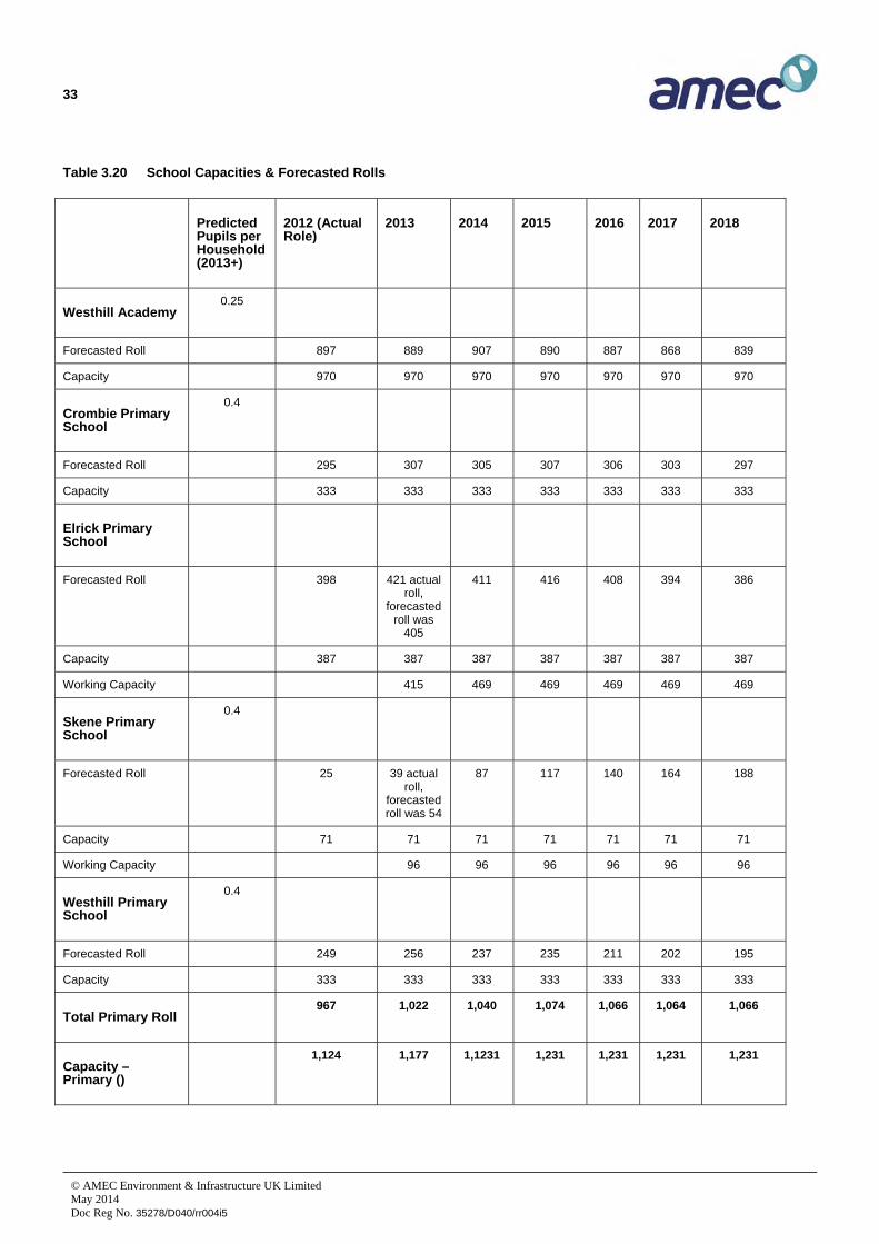
Primary School rolls are forecasted to increase by 14.2% and academies by 5.0% across Aberdeenshire between 2012 and 2018. Overall, it is forecast that there will be a considerable increase in pupil numbers – of the order of 10% - across most of Aberdeenshire up to 2018. Westhill is identified as one of the educational clusters likely to see significant growth in rolls, and projected school roll increases across Garioch account for half of the total forecasted net increase in school rolls within Aberdeenshire to 2018.
Table 3.20 details the capacities, current rolls and forecasted rolls at each of the five schools within Westhill. The catchment area of each school is shown on Figure 3.11.

32
© AMEC Environment & Infrastructure UK Limited May 2014 Doc Reg No. 35278/D040/rr004i5
Figure 3.11 School Catchments serving Westhill
33
© AMEC Environment & Infrastructure UK Limited May 2014 Doc Reg No. 35278/D040/rr004i5
Table 3.20 School Capacities & Forecasted Rolls
Predicted Pupils per Household (2013+)
2012 (Actual Role)
2013 2014 2015 2016 2017 2018
Westhill Academy 0.25
Forecasted Roll 897 889 907 890 887 868 839
Capacity 970 970 970 970 970 970 970
Crombie Primary School
0.4
Forecasted Roll 295 307 305 307 306 303 297
Capacity 333 333 333 333 333 333 333
Elrick Primary School
Forecasted Roll 398 421 actual roll,
forecasted roll was
405
411 416 408 394 386
Capacity 387 387 387 387 387 387 387
Working Capacity 415 469 469 469 469 469
Skene Primary School
0.4
Forecasted Roll 25 39 actual roll,
forecasted roll was 54
87 117 140 164 188
Capacity 71 71 71 71 71 71 71
Working Capacity 96 96 96 96 96 96
Westhill Primary School
0.4
Forecasted Roll 249 256 237 235 211 202 195
Capacity 333 333 333 333 333 333 333
Total Primary Roll 967 1,022 1,040 1,074 1,066 1,064 1,066
Capacity – Primary ()
1,124 1,177 1,1231 1,231 1,231 1,231 1,231

34
© AMEC Environment & Infrastructure UK Limited May 2014 Doc Reg No. 35278/D040/rr004i5
Table 3.20 indicates that although Westhill Academy, Crombie Primary and Westhill Primary are expected to have sufficient capacity to accommodate the forecasted pupil roll to 2018 and beyond, Elrick Primary is already operating above normal capacity levels and the roll at Skene Primary is forecasted to exceed ‘working capacity’ in 2015. However, a report to the Garioch Area Committee of Aberdeenshire Council in January 2014 regarding school accommodation management noted that “pupils expected from the Skene development (the Broadshade site)
are currently presenting at Elrick (Primary Schools) which has caused the greater than expected roll whilst Skene is presenting as lower than (previously) forecast”. To address capacity issues at Elrick Primary School an additional classroom has been created, giving an interim working capacity of 415, and two additional classrooms are planned to be completed within the school’s existing buildings by August 2014. No immediate capacity management measures are planned for Skene School, as the aforementioned school accommodation management report states that “owing to the roll being lower than that which is predicted officers shall monitor this on a monthly basis and action further accommodation when appropriate to meet the demands”.
Table 3.20 demonstrates that despite capacity issues arising at Elrick and Skene schools, overall the school estate within Westhill should be capable of accommodating forecasted rolls until 2018 and beyond. However, it should be noted that Aberdeenshire Council plan to undertake a catchment rezoning exercise in Westhill late in 2014 to address short term capacity issues at individual schools. In terms of any new school provision beyond 2018, Aberdeenshire Council Education Service standards suggest that any proposed new site for a primary school should be capable of taking up to 462 pupils, even if a school is not initially built of that size. Any potential new primary school site should be rectangular in shape, reasonably level and be at least 3.0 ha; with an upper limit of 5ha. Aberdeenshire Council Education Service has also indicated that a rezoning exercise may be undertaken towards the end of 2014.
3.7 Community Infrastructure (excluding Transport & Education)
3.7.1 Current Characteristics
Existing public services and leisure facilities within Westhill include2:
Free standing swimming pool on Westhill Academy campus (Hays Way)
Westhill Community Centre (Hays Way)
Westhill Library (Westhill Drive)
Westhill Golf Course (Westhill Heights)
Ashdale Hall: multi-purpose community hall (Westhill Road)
Denmen Park: bowling green, tennis court, Pavilion function room & kitchen (Old Skene Road)
Lawsondale Pavilion: two meeting rooms and outdoor pitches (Arnhall Crescent)
2 Access point/location denoted in brackets.

35
© AMEC Environment & Infrastructure UK Limited May 2014 Doc Reg No. 35278/D040/rr004i5
Peter Nicol Squash & Fitness Centre: private gym (Straik Road.A944)
Skene Health Centre. This incorporates Skene Medical Group GP practice, Westhill Clinic (providing District Nurses, Health Visitors, Physiotherapists, Occupational Therapy, Podiatrist and Speech Therapist, Community Psychiatric Nurse), the Westhill Social Work Department and an NHS Dental Practice. Visiting Consultants also hold clinics in Skene Healthcare Centre. (Discovery Drive)
Westdyke Leisure Centre (Westdyke Avenue)
Carnie all-weather pitch (Carnie Crescent)
Westhill Men's Shed (Hays Way)
3.7.2 Predicted Future Trends
In the short term, the Garioch area Community Planning Group (part of the Aberdeenshire Community Planning Partnership) is currently undertaking feasibility work regarding the provision of additional community facilities, potentially including the establishment of a youth cafe, within Westhill.
In the longer term, changes in the age profile of Westhill, and in particular an increase in the proportion of the population over 60 will likely result in an increased demand for healthcare within the town. Coupled with the population projections this may necessitate increased provision of GP and other primary care services.
3.8 Public Open Space & Public Realm
3.8.1 Current Characteristics
Open spaces serve a variety of functions including the provision of formal and informal recreation, shelter and natural habitat. The following areas of natural heritage significance contribute to the setting and character of Westhill:
Arnhall Moss;
Hill of Keir;
Denman Park;
Carnie Woods.

36
© AMEC Environment & Infrastructure UK Limited May 2014 Doc Reg No. 35278/D040/rr004i5
3.9 Utilities & Services
3.9.1 Current Characteristics
The 2008 capacity study stated that combined drainage from Westhill is pumped into the Aberdeen trunk sewer system, and while there are no capacity issues with the treatment works in Aberdeen City the trunk sewer system has limited capacity to cope with further flows. The 2008 capacity study also noted that due to current and planned development some of the sewage pumping stations in the area are at capacity and some of the water service reservoirs are close to capacity.
In terms of electricity infrastructure, a review of Ordanance Survey maps indicates that a high voltage overhead transmission line (OHL) passes immediately west of Westhill. This OHL cross the A944 at (E)381268 (N)806849 and runs directly south through the recently constructed Burnland housing development. The location and capacities of substations serving Westhill are not known to AMEC E&I at the time of writing this report.
3.9.2 Recent Trends
Available information suggests that no significant upgrades of the water and sewerage network which serves Westhill have taken place since the previous capacity study was prepared. However, the Aberdeenshire LDP 2016 Main Issues Report (2012) indicates that there is sufficient water treatment capacity available to support growth within the town.
3.9.3 Predicted Future Trends
Significant future development in Westhill will require the construction of a new wastewater pumping station to take flows from the site to the main pumping station. In addition to upgrading of the pumping system and improvements to the offsite sewers, such as the existing trunk sewer to Aberdeen, part of the receiving sewer network within Aberdeen may possibly require improvements. Under Scottish Water’s funding arrangements, new investment in drainage to service the level of expansion of Westhill envisaged in this study would have to be met by developers.
It should be noted that the provision of water and electricity infrastructure is inherently demand-led. Scottish Water and SSE Power Distribution have statutory obligations to provide connections to new development, although the cost of this must be met in full by developers.
3.10 Baseline Summary
Figure 3.12 identifies the main blocks of land use, the transport network and key facilities within Westhill, and also identifies sites in Westhill which are allocated within the Aberdeenshire LDP.

37
© AMEC Environment & Infrastructure UK Limited May 2014 Doc Reg No. 35278/D040/rr004i5
Figure 3.12 Baseline Summary Map

38
© AMEC Environment & Infrastructure UK Limited May 2014 Doc Reg No. 35278/D040/rr004i5
4. Constraints
Two broad magnitudes of geographical, technical and infrastructure constraints have been identified:
Absolute Constraints - issues which cannot be overcome due to cost or technical reasons within the 20 to 25 year period of this study and therefore require no further consideration; and;
Relative Constraints – issues which present difficulties but which could be tolerated or resolved within reasonable limits of cost and timescales. There is therefore merit in considering options to resolve these constraints within this study.
4.1 Geographic Constraints
4.1.1 Absolute Constraints
Topography: Steep slopes at Berryhill and Kiers Hill constrain development opportunities to the north of Westhill, while Hill of Ord constrains potential development south of Westhill.
4.1.2 Relative Constraints
The town’s rural setting and current greenbelt boundaries. Within the context of a planning application the Greenbelt land which surrounds Westhill would be considered as an absolute constraint, depending on the nature of the proposed development. The Aberdeen Green Belt was first established in 1958 and has largely remained in its present form since the last major review in 1986, although a technical review of Greenbelt land in Aberdeenshire was most undertaken in 2010 during the early stages of preparation for the Aberdeenshire LDP 2012. This confirmed that land to the east of Westhill should remain within the Greenbelt on the basis of the need to prevent coalescence between Westhill and Kingswells. However, given that this study is not concerned with individual developments and is predicated on the need to facilitate the growth of Westhill over a 20 to 25 year period, during which further Greenbelt reviews could occur, it is considered reasonable to categorise the current greenbelt boundary to the east of Westhill as a relative constraint.
Aberdeen City Boundary. Located approximately 0.5 km east of Westhill this political constraint does not itself prevent development from occurring south and east of Westhill. However, it limits the land area able to be planned by Aberdeenshire Council through its LDP. Any proposals to comprehensively develop land transcending the Aberdeenshire and Aberdeen City Council boundaries would be likely to generate significant cross boundary impacts and therefore should be considered within the next iteration of the Aberdeen City & Shire SDP.

39
© AMEC Environment & Infrastructure UK Limited May 2014 Doc Reg No. 35278/D040/rr004i5
4.2 Infrastructure Constraints
4.2.1 Absolute Constraints
The current alignment of the A944: this arterial route passes through central areas of Westhill in an east-west alignment and results in significant severance between housing land uses north of the A944, and predominantly employment land uses south of the A944. The land along either side of the A944 has been built on thereby restricting the opportunity to feasibly realign the A944.
Safeguarded areas for major gas and oil pipelines to the east and west of Westhill: these restrict development activity within the consultation distances3 of the pipelines to the outer zone and constrain opportunities to create a coherent settlement structure which integrates new development into the existing settlement pattern. The BP Forties oil pipeline runs to the east of Westhill and has an overall consultation distance of 485 metres either side of it. The consultation distance is subdivided into three zones:
Inner Zone: 0 – 110 metres;
Middle Zone: 110 – 380 metres;
Outer Zone 380 – 485 metres
The natural gas pipeline Leuchars Moss to Craibstone runs to the west of Westhill and has an overall consultation distance of 150 metres either side of the pipeline. Again, the consultation distance is subdivided into three zones:
Inner Zone: 0 – 32 metres;
Middle Zone: 32 – 105 metres;
Outer Zone 105 – 150 metres.
The consultation zones around these oil and gas pipelines restrict the amount and type of development which can take place in specific locations around Westhill. To remove this constraint it would be necessary to explore the possibility of relaying the pipelines in thicker walled pipe, which may reduce the overall consultation distance. Relaying the pipes would entail considerable expense and interruption to the supply of materials from the North Sea. If this was considered a viable option then sufficient pipe would need to be replaced to take account of further future development of Westhill beyond the scope of this Study.
Main electricity pylons to the west of Westhill. Similar to the gas and oil pipelines, a corridor around electricity pylons is subject to development constraints, particularly in terms of residential development.
3 The consultation distances listed in this section (4.2.1) are taken from the Westhill Capacity Study 2008. Research undertaken by AMEC E&I has not identified any evidence to indicate that these consultation distances have subsequently been altered by the UK Health & Safety Executive.

40
© AMEC Environment & Infrastructure UK Limited May 2014 Doc Reg No. 35278/D040/rr004i5
4.2.2 Relative Constraints
The lack of capacity in the existing local road network within Westhill. Congestion is a significant issue in Westhill.Problem junctions include the ‘six mile’ and Tarland junctions. Improvements to the ‘six mile’ junction are being delivered in conjunction with development at the Arnhall Business Park. However, a strategic solution to current congestion issues that would allow the long term expansion of Westhill has not yet been identified.
The lack of capacity of the education infrastructure within Westhill. According to the latest available school roll data Westhill Academy is projected to be at 91% capacity in 2016 and Skene Primary School is projected to be over capacity by 2015. However, it should be noted that the actual roll presented at Skene Primary School in 2013 (39 pupils) is significantly lower than projected roll (54 pupils), which implies that capacity constraints may not arise until after 2015.
4.3 Environmental & Cultural Heritage Constraints
Land covered by international, national or local environmental and cultural heritage designations requires to be protected from significant negative impacts which may arise from development. Therefore sites designated for their environmental or archaeological significance may constitute both absolute and relative constraints for the purposes of this study, depending upon the importance of the site and the scale of potential impacts.
Any new development within Westhill should address the following criteria:
protecting existing semi-natural areas,
developing habitat networks,
protecting water courses and wetlands, and
providing natural space within new development areas.
Following this process will ensure that existing open space is not fragmented by development and any new development itself can contribute to nature conservation and open space provision.
4.3.1 Statutory Designations
There are no statutory designated sites within the settlement boundary of Westhill, however protected sites within the wider study area include:
Loch of Skene SSSI and Special Protection Area – located approximately 2.3 km west of Westhill
Catchment of the River Dee Special Area of Conservation – located approximately 6.2 km south east of Westhill
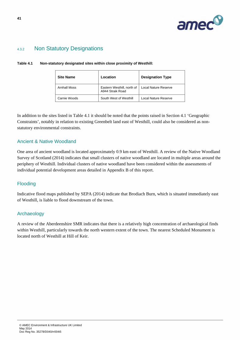
41
© AMEC Environment & Infrastructure UK Limited May 2014 Doc Reg No. 35278/D040/rr004i5
4.3.2 Non Statutory Designations
Table 4.1 Non-statutory designated sites within close proximity of Westhill:
Site Name Location Designation Type
Arnhall Moss Eastern Westhill, north of A944 Straik Road
Local Nature Reserve
Carnie Woods South West of Westhill Local Nature Reserve
In addition to the sites listed in Table 4.1 it should be noted that the points raised in Section 4.1 ‘Geographic Constraints’, notably in relation to existing Greenbelt land east of Westhill, could also be considered as non-statutory environmental constraints.
Ancient & Native Woodland
One area of ancient woodland is located approximately 0.9 km east of Westhill. A review of the Native Woodland Survey of Scotland (2014) indicates that small clusters of native woodland are located in multiple areas around the periphery of Westhill. Individual clusters of native woodland have been considered within the assessments of individual potential development areas detailed in Appendix B of this report.
Flooding
Indicative flood maps published by SEPA (2014) indicate that Brodiach Burn, which is situated immediately east of Westhill, is liable to flood downstream of the town.
Archaeology
A review of the Aberdeenshire SMR indicates that there is a relatively high concentration of archaeological finds within Westhill, particularly towards the north western extent of the town. The nearest Scheduled Monument is located north of Westhill at Hill of Keir.
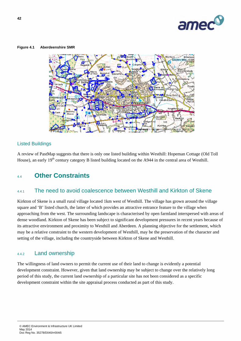
42
© AMEC Environment & Infrastructure UK Limited May 2014 Doc Reg No. 35278/D040/rr004i5
Figure 4.1 Aberdeenshire SMR
Listed Buildings
A review of PastMap suggests that there is only one listed building within Westhill: Hopeman Cottage (Old Toll House), an early 19th century category B listed building located on the A944 in the central area of Westhill.
4.4 Other Constraints
4.4.1 The need to avoid coalescence between Westhill and Kirkton of Skene
Kirkton of Skene is a small rural village located 1km west of Westhill. The village has grown around the village square and ‘B’ listed church, the latter of which provides an attractive entrance feature to the village when approaching from the west. The surrounding landscape is characterised by open farmland interspersed with areas of dense woodland. Kirkton of Skene has been subject to significant development pressures in recent years because of its attractive environment and proximity to Westhill and Aberdeen. A planning objective for the settlement, which may be a relative constraint to the western development of Westhill, may be the preservation of the character and setting of the village, including the countryside between Kirkton of Skene and Westhill.
4.4.2 Land ownership
The willingness of land owners to permit the current use of their land to change is evidently a potential development constraint. However, given that land ownership may be subject to change over the relatively long period of this study, the current land ownership of a particular site has not been considered as a specific development constraint within the site appraisal process conducted as part of this study.

43
© AMEC Environment & Infrastructure UK Limited May 2014 Doc Reg No. 35278/D040/rr004i5
4.5 Constraints Summary
Figure 4.2 below summarises the key constraints which are likely to affect potential development opportunities around the periphery of Westhill. It should be noted that these constraints are identical to those illustrated on Diagram B – Key Constraints of the 2008 Westhill Capacity Study (see Appendix C).
Figure 4.2 Key Constraints Map

44
© AMEC Environment & Infrastructure UK Limited May 2014 Doc Reg No. 35278/D040/rr004i5
5. Key Drivers of Change
5.1 Policy
National, regional and local planning policies as well as strategies in respect of economic and social development all have a significant influence on the current and future development of Westhill. To successfully implement the growth strategy which will be set out in Section 6 of this study there is a need to closely consider this policy context, therefore this section of the report provides a brief overview of relevant current and emerging policy documents.
5.1.1 Development Plan
The statutory development plan for Westhill currently comprises the approved Aberdeenshire Strategic Development Plan (2014) and the adopted Aberdeenshire Local Development Plan (LDP) (2012).
Aberdeen City and Shire Strategic Development Plan (2014)
The Aberdeen City and Shire SDP (2014) sets out a high level spatial strategy for the development of the region up to 2035, thus the document covers the entirety of the period which this study is concerned with. The document is underpinned by an over arching vision statement:
“Aberdeen City and Shire will be an even more attractive, prosperous and sustainable European city region and an excellent place to live, visit and do business. We will be recognised for: our enterprise and inventiveness, particularly in the knowledge economy and in high-value markets; the unique qualities of our environment; and our high quality of life. We will have acted confidently and taken the courageous decisions necessary to further develop a robust and resilient economy and to lead the way towards development being sustainable, including dealing with climate change and creating a more inclusive society.”
To implement this vision the introduction section of the SDP identifies two “main aims” and four “supporting aims”: The main aims of the plan are to:
“provide a strong framework for investment decisions which help to grow and diversify the regional economy, supported by promoting the need to use resources more efficiently and effectively; and
take on the urgent challenges of sustainable development and climate change”.

45
© AMEC Environment & Infrastructure UK Limited May 2014 Doc Reg No. 35278/D040/rr004i5
To support these main aims the plan also aims to:
“make sure the area has enough people, homes and jobs to support the level of services and facilities needed to maintain and improve the quality of life;
protect and improve our valued assets and resources, including the built and natural environment and our cultural heritage;
help create sustainable mixed communities, and the associated infrastructure, which meet the highest standards of urban and rural design and cater for the needs of the whole population; and
make the most efficient use of the transport network, reducing the need for people to travel and making sure that walking, cycling and public transport are attractive choices”.
All of these aims are relevant to this study given that it seeks to identify potential options for the sustainable growth of Westhill, including the identification of infrastructure requirements and measures to protect important natural and cultural heritage resources.
It should be noted that the vision and aims of the SDP summarised above are identical to those which were contained within the approved Aberdeen City & Shire Structure Plan which the SDP supersedes. This signifies that the SDP intends to continue along the established development trajectory, focusing in particular on exploiting opportunities for widespread economic growth as well as population growth within key settlements.
The SDP identifies that Westhill is located in a Local Growth and Diversification Area (LGDA) (rather than a Strategic Growth Area). The SDP includes a target that “at least 75% of all homes built, and employment land developed should be in the strategic growth areas”, which implies that all other areas of Aberdeenshire, including Westhill, should only be subject to limited growth. As such there is a clear requirement to closely relate the options for the growth of Westhill which is set out in Section 6 of this Study to the needs of the existing settlement. One implication of Westhill being located within a LGDA is that the SDP does not impose specific targets for the allocation of employment land within the settlement.
The “Objectives” section of the SDP identifies the importance of the oil and gas industry across North East Scotland and the need to support its future development, as well as the need to support traditional primary industries. This is important to Westhill given that the local economy is currently dominated by subsea engineering, which largely forms part of the wider oil and gas sector, and that a significant amount of the land which surrounds the existing settlement is in active agricultural use.
The SDP notes that Westhill is situated within the Aberdeen Housing Market Area (HMA) and notes that the adopted Aberdeenshire and Aberdeen City LDP’s currently allocate land for 1,000 dwellings within the LGDAs of the HMA up to 2016. The SDP identifies a further need to allocate land within the LGDAs of the Aberdeen HMA through a two phased approach: 1,350 dwellings from 2017-2026 and 1,350 dwellings from 2027-2035.
Schedule 2 of the SDP sets out a number of proposed infrastructure improvements which will help to implement the vision and aims of the plan. This includes reference to the Aberdeen Western Periphery Route. However, the SDP does not include any specific references, proposals or allocations which directly affect Westhill.

46
© AMEC Environment & Infrastructure UK Limited May 2014 Doc Reg No. 35278/D040/rr004i5
Aberdeenshire Local Development Plan
Adopted in 2012, the Aberdeenshire Local Development Plan (LDP) sets out a detailed spatial strategy for the development of the Council area to 2023, together with a number of development management policies which all development proposals must be assessed against.
The introduction to the LDP explains how each of the five objectives contained within the Structure Plan (and SDP) will be achieved through this document. There is a clear focus on ensuring that development supports the existing rural character of the majority of Aberdeenshire, including areas around Westhill. The document states that while Westhill is not located within a Strategic Growth Area Aberdeenshire Council propose “significant development” within the town. The LDP makes clear that Aberdeenshire Council wish to support the growth and prosperity of Westhill in line with the stated aims of the Strategic Development Plan.
The LDP includes fourteen subject specific policies, each of which relates directly to supporting policies which are detailed in a separate Supplementary Guidance document. A number of these policies, notably those relating to business development, greenbelt protection, housing land supply and developer contributions are of particular importance to this study. However, the relevance of individual policies to specific development opportunities within and around Westhill depends largely on the detailed characteristics of individual development proposals; therefore a detailed policy analysis of specific LDP policies would not be appropriate within this updated capacity study.
The LDP sets out a high level spatial strategy for Westhill, which is orientated around the following objectives:
“Meet the need for housing in the settlement, and the Aberdeen Housing Market Area.
Sustain existing services in a sub-regional centre.
Provide affordable housing in the settlement.
Maintain function as a successful employment centre.
Allow scale of development which does not cause problems for current infrastructure”
These objectives set out Aberdeenshire Council’s aspirations for Westhill and are therefore important to this study.
Overall the Aberdeenshire LDP promotes an ‘open for business’ approach and considers the development of business as being important to the economic health of the region. It supports the development of business and sustainable economic growth in all areas by taking account of the economic benefits of proposed development when making decisions in development management. Within the context of Westhill and the LDP this commitment to supporting economic growth is currently demonstrated through the allocation of employment land on the south eastern fringe of the town (site E1). The commissioning of this study with a specific remit to focus on opportunities for the expansion of employment land, provides further evidence of the commitment of Aberdeenshire Council to supporting sustainable economic growth within Westhill.

47
© AMEC Environment & Infrastructure UK Limited May 2014 Doc Reg No. 35278/D040/rr004i5
As detailed within earlier sections of this report, the LDP includes a number of land allocations within Westhill, in order to achieve the objectives noted above. These are summarised in Table 5.1 below:
Table 5.1 Summary of LDP Allocations in Westhill (Aberdeenshire Council, 2013)
Allocation/Proposal Details
Protected Land Development should not detrimentally affect these sites and their existing land uses.
P1 Site P1 is protected to conserve the nature reserve and provide land for access improvements.
P2 Site P2 is protected to conserve the Arnhall Moss Local Nature Reserve
P3 Site P3 is protected to conserve the playing fields.
P4 Site P4 is protected to conserve the playing fields.
P5 Site P5 is protected to conserve the playing fields.
P6 Site P6 is protected to conserve the playing fields.
P7 Site P7 is protected to conserve the amenity area
P8 Site P8 is protected to conserve the playing fields
P9 Site P9 is protected to conserve the play area.
P10 Site P10 is protected to conserve the golf course.
BUS Site BUS is safeguarded for employment uses.
TC The proposals map defines the extent of Westhill Town Centre.
Proposed Sites
H1 Site H1 is allocated for up to 190 houses (95 houses in the first phase and 95 houses in the second phase of the plan). A masterplan which details integration with the adjoining existing housing site is required. A recycling point should be provided on the site
H2 Site H2 is allocated for up to 10 houses in the first phase of the plan.
E1 Site E1 is allocated for employment land.
Infrastructure Requirements
There is need for 40% affordable housing on new housing developments within Westhill
H1 Developer contributions are required towards the provision of a replacement Household Waste Recycling Centre in Westhill. A recycling point is required within site H1.
Development Constraints
Pipelines There are various pipeline consultation zones in Westhill which must inform development proposals on existing and new sites.
Flood Risk A small watercourse runs alongside site E1.

48
© AMEC Environment & Infrastructure UK Limited May 2014 Doc Reg No. 35278/D040/rr004i5
5.1.2 Emerging Development Plan
Aberdeenshire LDP 2016
Despite Aberdeenshire Council only having adopted their first LDP in 2012, work has commenced on the next iteration of the LDP. The Main Issues Report (MIR) for the next LDP was subject to consultation until 1st February 2014. Question 18 and paragraphs 6.52-6.60 within the MIR relates to the provision of employment land specifically to support the growth of the subsea sector within Westhill. After setting out the recent history of Westhill’s housing and employment land allocations, the MIR notes the importance of the subsea sector and suggests that there may be a need to allocate additional employment land specifically to support the retention and expansion of subsea industries in Westhill. This Capacity Study responds to the MIR by examining potential development areas around Westhill which may be suitable for future employment land allocations.
1822 responses were received during the MIR consultation period, raising in excess of 5,000 individual issues. These will be reported to Aberdeenshire Council’s Area Committees and Infrastructure Services Committee during May and June 2014. Once all responses have been considered the LDP Proposed Plan will be prepared and published for consultation, which as of May 2014 is currently programmed for late Autumn 2014. The LDP Proposed Plan will then undergo a public examination process, expected to commence in winter 2015/2016, before being adopted. Aberdeenshire Council intend that the new LDP will be adopted for use at the beginning of 2017.
5.1.3 National Strategies, Plans & Policies
Government Economic Strategy (Scottish Government, 2011)
The SNP government’s first Government Economic Strategy (2007) identified the achievement of sustainable economic growth as the core purpose of the Scottish Government and this updated strategy re-confirms the importance of this central objective. The document gives clear priority to accelerating economic recovery, with a range of measures to tackle unemployment and promote employability. Actions are grouped around six strategic priorities which will drive sustainable economic growth and develop a more resilient and adaptable economy:
Supportive Business Environment –focused around supporting key growth sectors and growth companies and enabling Scottish firms to exploit international growth markets. This is directly relevant to Westhill given that the town’s subsea engineering sector has recently experienced significant growth, and although subsea engineering is not identified as one of six national growth sectors the document does identify “significant opportunities from Scotland’s science, technology and advanced engineering assets across sectors”. This provides high level policy support for the development of plans and strategies to facilitate sustainable growth of the subsea sector in Westhill.
Transition to a Low Carbon Economy – focused around a shift to renewable energy as well as resource and energy efficiency to reduce Scotland’s carbon emissions and adapt to climate change. This priority is relevant to Westhill given that offshore renewables is a potential growth sector for the subsea engineering industry, which has historically been dependant on oil and gas related work. In addition there is a need to ensure that the development of Westhill maximises resource efficiency, including in relation to the use of land, and supports sustainable travel options.

49
© AMEC Environment & Infrastructure UK Limited May 2014 Doc Reg No. 35278/D040/rr004i5
Learning, Skills and Well-being – focused around ensuring that Scotland’s population is equipped with the skills necessary to maximise their contribution to economic growth. This priority is relevant to Westhill given that the town’s main economic sector, subsea engineering, is dependent upon a highly skilled labour force. The priority is also relevant in terms of closing the spatial mismatch which currently exists between available jobs and the skills of the population in Westhill.
Infrastructure Development and Place – focused around ensuring adequate provision of physical and electronic infrastructures in order to maximise opportunities for economic growth, as well as enhancing the quality of areas as places to work and live. Enhanced infrastructure provision, notably in the local transport network, may be required in order to facilitate the enlargement of employment areas and the predicted growth in Westhill’s population. A focus on placemaking is of relevance to Westhill given that the settlement is home to a significant residential population yet arguably does not currently have a legible spatial structure.
Effective Government – focused around increasing the speed of decision making and enhancing co-ordination between public bodies. This priority is of relevance to Westhill given its close proximity to the Aberdeen City boundary and the fact that the majority of workers based in Westhill currently commute from Aberdeen. As such there is a clear need for Aberdeenshire Council and Aberdeen City Council to work together to enhance the integration of housing and labour markets and transport networks across the two areas.
Equity – focused on providing opportunities for the most disadvantaged areas and people in society to prosper. Although recent economic statistics indicate that Westhill is a prosperous area the long waiting list for council housing in the town points to This priority is also relevant in terms of ensuring that the community of Westhill is able to gain from the rapid growth of the subsea engineering economic sector in the town through enhancing opportunities for local employment and securing developer contributions towards infrastructure provision.
SPP (Scottish Government, 2010)
This document sets out the Scottish Government’s objectives, aspirations and expectations for the Scottish Planning System. In doing so the SPP aims to contribute to the achievement of the Scottish Government’s overarching purpose of realising sustainable economic growth, and the document is an important material consideration in all planning decisions.
The SPP aims to contribute to the achievement of the Scottish Government’s overarching purpose, sustainable economic growth. Paragraph 35 defines sustainable development in accordance with the five guiding principles contained within the UK Shared Framework for Sustainable Development (2005) and states that “the fundamental principle of sustainable development is that it integrates economic, social and environmental objectives”.
The significance of planning for achieving sustainable development is highlighted in paragraph 37, which states that “the planning system has an important role in supporting the achievement of sustainable development through its influence on the location, layout and design of new development”. In addition paragraph 37 notes that planning decisions should “contribute to the reduction of greenhouse gas emissions in line with the commitment to reduce
emissions by 42% by 2020 and 80% by 2050, contribute to reducing energy consumption and to the development of renewable energy generation opportunities”.

50
© AMEC Environment & Infrastructure UK Limited May 2014 Doc Reg No. 35278/D040/rr004i5
Paragraph 45 identifies 5 ways in which the planning system should support economic development:
“Taking account of the economic benefits of proposed development in development plans and development management decisions,
Promoting development in sustainable locations, particularly in terms of accessibility,
Promoting regeneration and the full and appropriate use of land, buildings and infrastructure,
Supporting development which will provide new employment opportunities and enhance local competitiveness, and
Promoting the integration of employment generation opportunities with supporting infrastructure and housing development.”
Paragraph 46 states that “planning authorities should ensure that there is a range and choice of marketable sites
and locations for businesses allocated in development plans, including opportunities for mixed use development, to meet anticipated requirements and a variety of size and quality requirements. Marketable land should meet business requirements, be serviced or serviceable within 5 years, be accessible by walking, cycling and public transport, and have a secure planning status”. The need to identify and allocate suitable land to meet business requirements provides a key rationale for this study.
Paragraphs 47 and 48 discuss the relationship between accommodating business development, supporting other land uses and protecting the environment. The SPP therefore prioritises development on brownfield land and states that “development plans should support small business development and growth and promote opportunities for low
impact industrial, business and service uses which can co-exist with housing and other sensitive uses without eroding amenity”.
The SPP also includes a wide range of other subject specific policies, the following of which are considered to be of particular relevance to this study:
Rural Development;
Historic Environment;
Landscape and Natural Heritage;
Housing
Transport; and
Flooding and Drainage.
Draft Revised SPP (Scottish Government, April 2013)
This draft document sets out proposed changes to national planning policies in order to more clearly reflect Scottish Ministers’ priorities for the development and use of land. A position statement issued in January 2014 outlines the

51
© AMEC Environment & Infrastructure UK Limited May 2014 Doc Reg No. 35278/D040/rr004i5
current thinking of the Scottish Government in relation to proposed key changes to the SPP and confirms that the Scottish Government expect to publish the finalised version of the SPP in June 2014.
Paragraphs 15-23 of the draft SPP explain how the planning system should contribute towards achieving the Scottish Government’s core purpose of achieving sustainable economic growth, and paragraphs 24-27 provides policies regarding how planning should contribute to sustainable development. It should be noted that since the publication of the draft SPP in April 2013 the Scottish Government has consulted on replacing these draft policies regarding sustainable development and sustainable economic growth with a revised ‘sustainability & planning’ section; this would establish a presumption in favour of sustainable development and define the concept of sustainable development in accordance with the recognised Brundtland definition.
Paragraph 17 of the draft SPP identifies four roles for the Scottish planning system in achieving sustainable economic growth, all of which are relevant to this study:
“The planning system should:
through the development plan, set out a spatial strategy to deliver sustainable economic growth. This should harness the strengths and qualities of cities, towns and rural areas;
foster a business environment which is supportive to new investment across Scotland while protecting and enhancing the quality of the natural and built environments as assets of national importance;
attach significant weight to economic benefit of proposed development as a material consideration, particularly the creation of new jobs, recognising and responding to economic and financial conditions; and
support infrastructure delivery and innovation in the energy, transport, construction, digital, waste, water and environmental management sectors to support the transition to a low carbon economy”
The weight to be afforded to economic development considerations in planning decisions is clarified in paragraph 23, which states that “decision makers should give full consideration to the need for planning to support sustainable economic growth”.
The draft revised SPP sets out a number of principle and subject policies which are relevant to specific development types and cross-sectoral planning issues. In relation to business and employment provisions, the draft revised SPP at paragraph 106 states that development plans “should meet the needs and opportunities of indigenous firms and inward investors”, and in this regard paragraph 110 requires LDPs to allocate and regularly review a range of marketable sites for business uses. In relation to the protection of town centres, the draft revised SPP at paragraph 55 advises that regular town centre health checks should be undertaken by local authorities, while paragraph 56 lists a number of actions which should be undertaken to support town centres, including the preparation of town centre strategies and the establishment of Business Improvement District.

52
© AMEC Environment & Infrastructure UK Limited May 2014 Doc Reg No. 35278/D040/rr004i5
NPF 2
Scotland’s Second National Planning Framework (NPF2) provides a national spatial vision around which to orientate socio-economic development and highlights the spatial planning implications arising from other Scottish Government policy documents, including the updated Government Economic Strategy (2011). Paragraph 12 of NPF2 explains that the NPF2 “takes forward the spatial aspects of the Government Economic Strategy, to ensure
that each part of the country is able to play to its strengths in building a Scotland that is wealthier and fairer, smarter and greener, healthier, safer and stronger”.
NPF2 identifies several key challenges which currently influence Scotland’s socio-economic development and are likely to develop over the lifetime of the framework, before providing a spatial strategy to address these issues. Identified key challenges of relevance to this study include:
The importance of placemaking to attract and retain both investment from firms and a highly skilled workforce;
The need to tackle climate change through reducing carbon emissions and adapting to a changing environment. In particular there is a need to “improve the accessibility of education, employment and services and encourage a shift to more active and sustainable modes of travel and transport”. The planning system can contribute to this by promoting “compact settlements, mixed use development, effective active travel networks and efficient public transport systems”.
Ensuring that housing, transport and community facility provision reflects Scotland’s demography, in particular the ageing population.
Four key aims underpin the spatial strategy contained within NPF2. These aims are:
“to contribute to a wealthier and fairer Scotland by supporting sustainable economic growth and improved competitiveness and connectivity;
to promote a greener Scotland by contributing to the achievement of climate change targets and protecting and enhancing the quality of the natural and built environments;
to help build safer, stronger and healthier communities, by promoting improved opportunities and a better quality of life; and
to contribute to a smarter Scotland by supporting the development of the knowledge economy”.
To achieve these key aims NPF2 identifies the need to:
Create a knowledge driven economy with a highly skilled labour force. This requires Scotland to be “well connected economically, physically, digitally and intellectually to the rest of the world”.
Maximise energy efficiency and opportunities for the exploitation of Scotland’s renewable energy resources. In relation to climate change paragraph 48 states that “planning and transport policies can make an important contribution by promoting more sustainable patterns of land use and travel”.
Integrate economic development with environmental protection and sustainable resource management.
53
© AMEC Environment & Infrastructure UK Limited May 2014 Doc Reg No. 35278/D040/rr004i5
Paragraph 53 summarises the development strategy contained within the NPF2. Pertinent aspects of the strategy for the purposes of this study include the need to:
“Support strong, sustainable growth for the benefit of all parts of Scotland;
promote development which helps to reduce Scotland’s carbon footprint and facilitates adaptation to climate change;
support sustainable growth in the rural economy;
conserve and enhance Scotland’s distinctive natural and cultural heritage, and continue to safeguard internationally protected sites, habitats and species;
expand opportunities for communities and businesses by promoting environmental quality and good connectivity;
promote more sustainable patterns of travel, transport and land use;
realise the potential of Scotland’s renewable energy resources and facilitate the generation of power and heat from all clean, low carbon sources; and,
encourage a sufficient supply of homes which are affordable in places where people want to live.
NPF3 Proposed Plan
As required under the Planning etc. (Scotland) Act 2006, the NPF3 Proposed Plan was laid in the Scottish Parliament on 14th January 2014 for its formal consideration. It is expected that following a period of parliamentary scrutiny the finalised version of the NPF3 will be published in June 2014.
The NPF3 Proposed Plan confirms the Scottish Government’s commitment to increasing sustainable economic growth and therefore orientates the efforts of Scotland’s planning system towards this purpose. The document sets out a national spatial strategy structured around four key themes:
A successful, sustainable place: This theme is underpinned by the objective of creating “high quality, diverse and sustainable places that promote well-being and attract investment”. The document calls for a renewed focus on exploiting the Scotland’s natural resources and a focus on emerging growth sectors. This is of critical importance to this study given that Westhill has recently become a subsea engineering centre of excellence yet and surrounded by agricultural land. Page 12 of the NPF3 Proposed Plan sets out a detailed spatial strategy for Aberdeen and North East Scotland which acknowledges the importance of supporting energy related industries and identifies a particular need to provide additional affordable housing across the region.
A low carbon place: This theme relates to the legally binding target of reducing Scotland’s greenhouse gas emissions by 80% by 2050 compared with 1990 levels, as set out in the Climate Change (Scotland) Act 2009. The document notes that the Scottish Government has adopted several renewable energy targets including the aim of generating “at least 30% of overall energy demand from renewables by 2020 – this includes generating the equivalent of at least 100% of gross electricity consumption from renewables, with an interim target of 50% by 2015”. The Scottish Government’s

54
© AMEC Environment & Infrastructure UK Limited May 2014 Doc Reg No. 35278/D040/rr004i5
support for the deployment of renewable energy is indirectly of relevance to this study given that the offshore renewables industry is an emerging growth market for the subsea engineering sector which has established itself in Westhill.
A natural, resilient place: This theme is concerned with environmental protection and the sustainable use of Scotland’s natural resources. It is noted that Scotland’s principal asset is the land, which must be managed sustainably as both an economic resource and environmental asset. In addition the document states that “water management and flooding issues will become increasingly important” due to the effects of climate change, and it identifies the need to manage tensions between accommodating development pressures and protecting productive agricultural land which surrounds urban areas. This issue is of critical importance for Westhill given that any potential growth of the settlement is likely to encroach upon active agricultural and/or greenbelt land.
A connected place: This theme is orientated around maximising physical and digital connectivity around Scotland and between Scotland and the rest of the world. In relation to Aberdeen the consented Aberdeen Periphery Route and the proposed dualing of the A90 between Balmedie and Tipperty are cited as key infrastructure projects, and the document notes the overall need to improve the accessibility of rural areas through improvements to digital and transport infrastructure. Of specific relevance is that the NPF3 Proposed Plan at paragraph 5. 26 encourages local authorities to “identify one walking- and cycling-friendly settlement where accessibility will be significantly improved by 2030”. Given that an extensive cycle network already exists within and around Westhill, potential future upgrades to the network could enable Westhill to bid for national recognition as a ‘Sustainable Transport Town’ or ‘Cycle Town’.
The NPF3 Proposed Plan identifies 14 proposed National Developments, none of which are in close proximity to Westhill. Therefore they are not expected to directly affect the settlement’s development. However, a National Long Distance Cycling and Walking Network is identified as the 7th proposed National Development, and despite Westhill not being identified within the scope of this proposed National Development, this designation could still provide indirect policy support for future improvements to long distance walking and cycle routes close to Westhill.
5.1.4 Regional and Local Plans & Strategies
This section identifies key points within current regional and local policy documents which have the potential to influence the development of Westhill. It should be noted that this section does not aim to provide a comprehensive analysis of the Aberdeenshire or North East Scotland policy environments. As such a range of other policy documents not addressed within this section may also influence the development of Westhill over the next 25 years.
The Economic Manifesto for Aberdeen City and Shire (ACSEF, 2007)
This document sets out a vision and strategic priorities for the region to work towards by 2025. It identifies eight priorities, the first being for Aberdeen City and Aberdeenshire to be the top of the Quality of Life “league table”, making it a place where people choose to work, live study and visit. The remaining seven are:-
Deliver a fully integrated transport network
Maximise our intellectual capital - people and expertise

55
© AMEC Environment & Infrastructure UK Limited May 2014 Doc Reg No. 35278/D040/rr004i5
Deliver city centre redevelopment
Anchor the oil and gas industry
Attract and develop skilled people
Improve the efficiency of planning decision making
Aberdeen City and Shire as the location of choice for company headquarters
Nestrans Regional Transport Strategy Refresh 2013
The Regional Transport Strategy (RTS) for Aberdeen City and Shire was first adopted as a statutory document in 2008 following approval by Scottish Ministers. This RTS built on the previous strategy to 2011, referred to as the Modern Transport Strategy or MTS. In 2013 Nestrans undertook a review of the RTS to take account of a number of changes in policy, in particular to better align the document with the approved Structure Plan and emerging Strategic Development Plan. This resulted in the publication of this refreshed RTS, which was approved by Scottish Ministers on 16th January 2014.
The refreshed RTS is underpinned by the vision of creating:
“A transport system for the north east of Scotland which enables a more economically competitive, sustainable and socially inclusive society”
To implement this vision the document identifies four strategic objectives and a number of constituent aims. The strategic objectives are to:
“To enhance and exploit the north east’s competitive economic advantages, and reduce the impacts of peripherality.
To enhance choice, accessibility and safety of transport for all in the north east, particularly for disadvantaged and vulnerable members of society and those living in areas where transport options are limited.
To conserve and enhance the north east’s natural and built environment and heritage and reduce the effects of transport on climate, noise and air quality.
To support transport integration and a strong, vibrant and dynamic city centre and town centres across the north east”.
The RTS sets out a strategic framework of integrated measures and interventions in order to achieve these strategic objectives and the overall vision. Table 5.1within the RTS identifies routes where strategic transport infrastructure improvements are required to cope with the cumulative impact of development; the ‘A944 corridor’ is identified as one such route where upgrades to key junctions are needed in order to improve safety and increase capacity. However, this high level strategy does not detail the characteristics of potential upgrades to the A944, as it states that “a full appraisal and assessment, detailed engineering design and environmental assessment of each location will be required in order to progress these interventions and identify the most appropriate solution for each”.

56
© AMEC Environment & Infrastructure UK Limited May 2014 Doc Reg No. 35278/D040/rr004i5
In addition to infrastructure improvements required to alleviate cumulative development pressures the RTS focuses on:
reducing congestion on strategic roads,
reducing journey times using rail transport,
creating transport interchanges to facilitate connections between local and regional bus services
undertaking quality bus corridor improvements to improve bus service frequencies and reliability
undertaking urban realm improvements to improve pedestrian environments
implement measures to increase safety and security of walking
These themes emphasise the importance of improving the performance of existing transport infrastructure. Due to the limited public transport network around Westhill and its lack of proximity to strategic roads and the rail network many of these themes are of limited relevance to Westhill. However, in line with the RTS measures could be taken to increase patronage on bus services which pass through Westhill by upgrading interchange points.
It should be noted that although the RTS does refer to the consented Aberdeen Western Periphery Route this project is considered to be part of the “reference case” (i.e. the baseline position) for the future development of the region’s transport network and therefore the merits and potential impacts of the AWPR are not discussed within this document.
Aberdeenshire Local Transport Strategy 2012
In January 2012 Aberdeenshire Council adopted its new Local Transport Strategy (LTS) which outlines the key transport issues affecting Aberdeenshire and sets out a series of actions to support delivery of a transport vision for the area. The overall aim of the LTS is to “to encourage individuals and businesses to consider ways to travel less, travel more actively and, where vehicular travel is necessary, how journeys could be made more effectively”. The LTS identifies five main issues which require to be addressed:
Economic issues – there is a need to “to support the traffic growth associated with economic development while ensuring that network capacity is safeguarded”. An associated challenge is providing adequate public transport across rural areas of Aberdeenshire at a time when bus/rail fares are rising rapidly. Both of these issues are of direct relevance to Westhill due to the existing road capacity constraints which exist in the town and the relatively limited availability of public transport.
Environmental issues – there is a need to reduce the environmental impact of transportation within Aberdeenshire, particularly in terms of carbon emissions. This is challenging given the rural nature of Aberdeenshire.
Safety issues – there is a need to ensure the safety of all users of the transport network in Aberdeenshire, including through reducing road casualty rates. The LTS supports the delivery of the Joint Road Safety Plan for Aberdeen City & Shire 2011-2015.

57
© AMEC Environment & Infrastructure UK Limited May 2014 Doc Reg No. 35278/D040/rr004i5
Integration issues –to enhance accessibility and encourage sustainable modal shifts there is a need to achieve greater inter-modality and seamlessness within local transport networks.
To respond to these main issues the LTS is underpinned by five objectives:
Promote Sustainable Economic Growth – maximise the effectiveness of the transport network, services and facilities;
Promote Social Inclusion and Accessibility – improve connections within and between communities, increasing accessibility of the transport network;
Protect the Environment – remove barriers to active and sustainable travel helping to improve health and reduce emissions.
Improve Safety – enhance the safety of all users of the transport network.
Improve Integration – develop and improve integration between all forms of transport and improve connectivity within and beyond Aberdeenshire.
It should be noted that whilst the LTS is an important document it does not include any specific references or proposals in relation to Westhill.
5.2 Other Drivers of Change
Local & Regional Governance Interactions
The geographical situation of Westhill, located within the Aberdeenshire Council area but adjacent to the eastern boundary with Aberdeen City, necessitates that the future development of Westhill should involve at least a degree of collaboration between relevant governance bodies. This study has not undertaken a full mapping exercise to comprehensively identify all governance bodies of relevance to Westhill; however it is evident that relevant governance bodies include Aberdeenshire Council, Aberdeenshire Community Planning Partnership, Aberdeen City Council, Nestrans, the Aberdeen City & Shire Economic Forum and the Aberdeen City & Shire SDPA. All of these bodies effectively control at least one aspect of the policy environment which will influence change in Westhill over the next 25 years, so any coherent strategy to facilitate the future development of Westhill should be informed by the priorities and aspiration of these different governance bodies and ideally should be co-ordinated between them.
Long Term Drivers
In addition to the influence of national, regional and local policies the development of Westhill will be conditioned by a large number of external factors which cannot be considered in detail within this study. These factors include: constitutional change, volatility in the North Sea oil and gas economy and the international and national economy more widely, climate change, technological innovation, changes in consumer behaviour and lifestyle shifts. Although all of these factors could have a significant influence on the future development of Westhill, fluctuations in oil and gas prices are particularly important given the dominance of the oil and gas sector in the north east

58
© AMEC Environment & Infrastructure UK Limited May 2014 Doc Reg No. 35278/D040/rr004i5
economy. Major shifts in oil prices have a direct impact on the oil and gas supply chain, including the subsea engineering sector, and therefore can influence companies’ aspirations and appetite for expansion in Westhill.
59
© AMEC Environment & Infrastructure UK Limited May 2014 Doc Reg No. 35278/D040/rr004i5
6. Spatial Analysis
This section seeks to identify the key issues which a growth oriented spatial strategy should address. The key issues detailed in section 4.2 are closely informed by the information contained within sections 2-5 of this report, as well as the analysis of current strengths, weaknesses, opportunities and threats (SWOT) in Westhhill which is outlined below.
6.1 SWOT Analysis
A SWOT analysis was undertaken to identify issues of potential relevance within Westhill and to help identify the key issues (section 4.2) which should be considered in the options for growth detailed in Section 8.
6.1.1 Strengths
Population
Westhill has experienced significant population growth since its inception and this is projected to continue, indicating that the settlement is a popular place to live. Coupled with the recent surge of employment related development this provides opportunities to promote mixed use development and to create a ‘liveable’ settlement, whereby the majority of the population live, work and relax within Westhill.
The significant and rising population provides a potential labour pool for businesses within Westhill.
Housing
Recent housing developments in Westhill at the Broadshade and Burnland sites indicate that the town has a thriving housing market. Major housebuilders appear eager to invest in new development sites, with several having headquarter/regional offices in Westhill. Such investment will contribute to the development of the town’s infrastructure through planning agreements or other developer contributions.
The dominance of family housing within Westhill supports the retention of a mixed age community within the town.
Economy & Retail
Westhill is demonstrably able to attract inward investment from world leading firms, particularly in the subsea engineering sector.
Much of subsea sector’s work in Westhill currently revolves around the oil and gas industry. However, some activity does take place in the growth sector of renewables; Technip Offshore Wind moved its world offshore wind HQ from Paris to Westhill. Thus the subsea cluster in Westhill has a diverse range of clients and is relatively resilient to changes in the circumstances of individual clients.

60
© AMEC Environment & Infrastructure UK Limited May 2014 Doc Reg No. 35278/D040/rr004i5
Although fossil fuel recovery rates in the North Sea are declining, conservative estimates suggest that a further 40 years of activity is expected and the value of unrecovered oil and gas is estimated at £1 trillion. Subsea technologies are likely to become more important for increasing extraction rates in brownfield wells and for extracting oil and gas from hard to reach new fields.
Engineering design and project management work is undertaken in Westhill for projects around the world, indicating that the subsea engineering cluster in Westhill is not solely reliant on North Sea oil and gas industries.
A number of public sector bodies including Scottish Water have an employment presence within Westhill.
The growing subsea engineering sector within Westhill induces an unknown economic multiplier effect, particularly for ‘local’ service based industries and the associated workforce.
The Westhill Shopping Centre acts as the designated Town Centre for Westhill, providing a focus in the settlement, comprising a reasonable range of convenience and comparison retail units. Planning permission for an extension to the centre was granted in 2013; this indicates that it is performing well financially and that the range of shops & services is expected to increase.
There is a retail presence within the Arnhall Business Park area of Westhill, in the form of large Tesco and Costco outlets. In particular the Tesco store provides a source of low order convenience goods for employees based within the Westhill and Arnhall Business Parks.
Open Space
Despite experiencing significant housing and employment related growth Westhill has managed to retain important open spaces, including playing fields and the Arnhall Moss Local Nature Reserve.
Westhill is almost entirely surrounded by open countryside, much of which is in active agricultural use. Agriculture is a historically important industry across Aberdeenshire and the sector continues to thrive.
The land which surrounds Westhill is largely undeveloped (although in active agricultural use), therefore providing a range of potential development sites.
Infrastructure
The A944 provides a direct route from Westhill to Aberdeen, thereby facilitating cross-commuting.
Work is ongoing to reconfigure the Six Mile Roundabout on the A944 into a controlled junction, which should help to alleviate traffic congestion on the eastern approach to Westhill.
The forthcoming AWPR will be located east of Westhill and will include a junction with the A944. The new road is intended to alleviate current pressures on the A944 and will provide a direct and quick link from Westhill to many areas of Aberdeenshire and Aberdeen City.

61
© AMEC Environment & Infrastructure UK Limited May 2014 Doc Reg No. 35278/D040/rr004i5
The creation of the AWPR within the Greenbelt east of Westhill provides an opportunity to review the effectiveness of current Green Belt boundaries, and potentially facilitate limited development of appropriate land uses on suitable sites immediately east of the existing settlement.
Although the A944 provides the main access road into Westhill there are a number of ‘B’ class roads which connect northern and southern areas of the town to the wider area. The capacity of these roads is likely to be of critical importance for determining suitable options for new development on land around Westhill.
Westhill has relatively good bus connectivity, considering the size and semi-rural situation of the settlement, and good pedestrian and cycle links to the east.
The existing and planned future transport network provides good connectivity between Westhill and Aberdeen, which acts as an important investment driver for firms locating in the town.
Community Facilities
The total primary and secondary school capacities are predicted to exceed forecasted roles from at least 2018. This provides an opportunity to facilitate limited additional housing development in Westhill over the short term if required in order to support employment related growth.
Skene Health Centre provides a comprehensive range of health services in a modern and reasonably centrally located building to residents of Westhill. This removes the need to travel outwith the town for many medical appointments.
Westhill is served by a relatively wide range of public and private leisure facilities, including a community swimming pool and a new library. The provision of high quality amenities within Westhill helps to attract businesses and people to live, work and invest in the town.
6.1.2 Weaknesses
Population
Like many parts of Scotland the population of Westhill, is expected to undergo significant ageing over the next 25 years, which could result in increased pressure on health and social care services within the town. This is potentially of concern given that the existing GP practice, Skene Medical Group, which currently serves a large population and is operating at near capacity. Population ageing is likely to reduce mobility and therefore constrain access to important high order services located in Aberdeen for elderly residents of Westhill.
Housing
Although absolute numbers of housing in Westhill are currently adequate there is a lack of diversity and choice in housing provision, in terms of both housing tenure and type. Westhill is dominated by owner occupied private family dwellings and currently has a very low percentage of council and socially rented housing. In addition the town has limited provision of flatted dwellings and small homes suitable either for young professionals without families or older residents who wish to downsize.

62
© AMEC Environment & Infrastructure UK Limited May 2014 Doc Reg No. 35278/D040/rr004i5
Housing and employment land uses are relatively detached and homogenous, with little evidence of true mixed use development within Westhill. This undermines the spatial identity and sense of place within the town.
Economy & Retail
The rapid take up of allocated employment land in 2012/2013 means that the only site allocated for employment in the 2012 LDP is now under construction. Therefore there is effectively no established employment land supply in Westhill. Therefore, to respond to development pressures and support economic growth new areas of suitable land should be allocated for employment uses.
Economic growth and employment in Westhill is currently underpinned by a small number of key economic sectors, notably subsea engineering which is largely reliant on work related to oil and gas extraction. This lack of economic diversity is arguably a weakness as it undermines the economic resilience of the town. Without the subsea engineering sector it is likely that Westhill would not have experienced the recent employment related growth that has occurred.
The majority of the office developments which house Westhill’s subsea engineering cluster are owned by commercial landlords rather than subsea engineering firms. Therefore the subsea engineering sector is not physically tied to Westhill and these firms could chose to relocate to (lower cost) locations outside of Westhill at the end of their leases. If this was to occur it would significantly reduce the growth potential of Westhill, at least in the short term, due to the current dominance of the subsea sector within the town.
Housing and employment land uses are relatively detached and homogenous, with little evidence of true mixed use development within Westhill. This undermines the spatial identity and sense of place within the town.
Although the Westhill Shopping Centre and surrounding land is designated a Town Centre, in reality this area is currently unable to fulfil some important Town Centre functions. In particular the poor quality of public realm around the shopping centre prevents it from being a well frequented meeting point and social space, despite its relatively central location.
There is currently no provision for high order retail shops or services within Westhill. This necessitates travelling to Aberdeen City for specialist purchases.
Open Space
Carnie Woods Local Nature Conservation Site, located on the south west fringe of Westhill, is now enclosed by development on several sides.
There are a limited number of footpaths running from Westhill into the surrounding area.
Infrastructure
A key weakness is that there is only one arterial route into and through Westhill, the A944. This road is subject to significant congestion during peak periods, as well as air pollution (nitrogen oxide and particulate matter) and carbon emissions associated with high volumes of traffic.

63
© AMEC Environment & Infrastructure UK Limited May 2014 Doc Reg No. 35278/D040/rr004i5
Capacity issues on the B9119 and B979 and at junctions on the A944 currently constrain development opportunities immediately south of Westhill.
Traffic congestion affects local distributor roads within Westhill, as well as on the A944.
There is lack of connectivity between the A944 and B9119.
Due to separate street design processes for each development poor connectivity exists within and between areas of the Westhill Business Park and the Arnhall Business Park.
Some utilities infrastructure within Westhill may be operating near to capacity and thus may require to be upgraded in order to facilitate development.
Oil and gas pipeline infrastructure means that particular corridors within Westhill simply cannot be built on. As well as preventing development of specific sites this restricts opportunities to create a coherent and integrated spatial structure across Westhill.
Community Facilities
The population of Westhill is expected to grow however capacity issues already exist at several primary schools. This could impede future housing or mixed use development within the town.
Existing public service provision is predominately on the eastern side of Westhill. Any strategy to develop Westhill should address this imbalance by providing additional community facilities in western areas of the town. This is particularly important given that the west of Westhill has recently experienced substantial housing growth through the Burnland and Broadshade developments.
6.1.3 Opportunities
Westhill has clearly seen significant growth in recent years
Westhill provides a mix of housing and employment opportunities and there appears to be demand for further such provision
There is considerable opportunity for development of a sub-sea centre of excellence in Westhill, building on its existing strengths
The AWPR, when developed, will be in close proximity to Westhill and will considerably improve accessibility.
Westhill is an important strategic town in the City and Shire area and this is demonstrated by the demand for housing and employment in the town.
Scottish Planning Policy advises (para.46) that development plans should provide a range and choice of marketable employment sites to meet anticipated requirements.
The sub-sea sector is a key driver of economic growth of Westhill, as well as the sub-regional, regional and national economies. In this context, there is the opportunity to specifically recognise Westhill’s status and contribution to the economic growth of the area

64
© AMEC Environment & Infrastructure UK Limited May 2014 Doc Reg No. 35278/D040/rr004i5
The land immediately south of Westhill & Arnhall Business Parks may represent a logical extension to the established employment land supply, particularly if new sites are to be tailored to the needs of the subsea cluster which is located within the Business Parks. However, to accommodate new development on land south of Westhill significant infrastructure would be required to address capacity issues on the B9119 and B979.
Despite the presence of the Greenbelt and Aberdeen City boundaries there may be scope to develop mixed use areas immediately east and north east of Westhill.
A sufficient and growing population base (together with the homes and jobs that that entails) provides the opportunity, and is required, to support services and facilities at a level appropriate to improve the quality of life.
Given current and anticipated economic activity it is prudent to plan for growth and ensure sufficient land is available to satisfy market demand.
The faster the level of population growth inevitably means that business also requires a more generous supply of land to be made available, which will in turn provide sufficient confidence to encourage continued inward investment
Economic activity west of Aberdeen City has increased significantly since 2009 (e.g. Westhill), despite the Strategic Growth Areas designation not including this area. The A944 is of strategic importance to Westhill/Aberdeen; opportunity for more housing development west of the City so that housing is close to employment opportunities at Westhill. Opportunity to develop and deliver accessible transport links.
Housing diversity and choice in Westhill could be enhanced by integrating relatively high density flats with areas of office blocks and low order retail in order to provide housing for young professionals and create mixed use, ‘livable’ neighbourhoods.
Westhill Business Park is owned by Aberdeenshire Council, which may facilitate the reconfiguration of the Business Park and improve its efficiency.
6.1.4 Threats
Although Westhill is expected to retain a sizeable working age population over the next 20 to 25 years, a rapidly ageing population combined with low levels of immigration could reduce the town’s labour pool.
If the identified lack of housing diversity and choice is left unresolved this could cause a blockage in the local housing market and present difficulties for attracting and retaining the highly skilled labour force required to service the growing subsea engineering sector.
A lack of planned new land for housing may encourage speculative applications for residential development, which may exacerbate rather than improve issues related to housing tenure/type, with a commensurate impact on infrastructure capacity. Speculative housing development could also exacerbate existing deficiencies in Westhill’s overall spatial structure.
65
© AMEC Environment & Infrastructure UK Limited May 2014 Doc Reg No. 35278/D040/rr004i5
If educational capacity issues are not resolved this may constrain future housing development in Westhill, which could have a knock-on effect on the town’s labour market.
If sufficient employment land is not provided to meet local needs, this may prevent economic development from occurring. Specifically, if suitable sites are not identified for the growing subsea cluster this would constrain the sector’s growth and could ultimately lead to the relocation of one or more subsea firms out of Westhill. If this were to happen it could threaten the viability of the Westhill subsea cluster, as the main reason why the subsea industry has developed a centre of excellence in the town relates to the economic benefits generated through agglomeration.
Potentially increasing competition from outwith Aberdeenshire to attract the sub-sea market sector. The Employment Land Audit 2012 (published May 2013) states, for example, that in recent years take up of land has been much higher in Aberdeenshire, partly as a result of the shortage of suitable sites in Aberdeen, but there are indications that take up in both areas is increasing.
The Reporter of the Proposed ACSSDP Examination Report (p.132 para.15) supported the contention of the SDP Authority that the significant expansion of Westhill took place at a time when such development opportunities within Aberdeen itself were limited. This is no longer the case, with significant allocations being brought forward within the A944 corridor at Kingswells and at Countesswells. The reporter concluded ‘that significant expansion at those locations would represent a better fit with the spatial strategy and sustainability objectives of the plan than would be the case at Westhill.’
If Westhill depends upon the subsea engineering sector for its prosperity this could limit local employment opportunities, as only a limited number of potential employees who reside in Westhill are likely to have appropriate skills and qualifications for the subsea industry. One consequence of this would be a need for increased commuting, which would generate significant negative social and environmental impacts.
If Westhill depends upon the subsea engineering sector for its prosperity and the sector experiences rapid decline, the socio-economic prosperity of the town would also sharply decline.
Historically poor recognition to the role of community facilities in supporting growth, and the ability of the existing public facilities to support existing, new and expanded communities. Need to ensure that future growth is not constrained by lack of infrastructure (e.g. health care, community and leisure facilities); the local communities should benefit/gain from growth.
Development without appropriate infrastructure could lead to under capacity on the road network and result in significant social, economic and environmental impacts. If development continues without appropriate and reasonable infrastructure improvements this could weaken the attractiveness of Westhill to employers/investors.
Increased traffic on the A944 as a result of new development could exacerbate existing severance issues.
6.2 Key Issues
The contextual information, spatial analysis and sustainability objectives reported earlier in this report highlights multiple key issues which are of key importance to the future development of Westhill. Of particular importance

66
© AMEC Environment & Infrastructure UK Limited May 2014 Doc Reg No. 35278/D040/rr004i5
and relevance to the framework for the future growth of Westhill over the next 20 to 25 years is the spatial strategy and sustainability objectives contained within the approved Aberdeenshire Strategic Development Plan (2014) which identifies Westhill as being located within a Local Growth and Diversification (LGD) area. These means that any further development should be integrated with and compliment the existing settlement. Paragraph 3.11-3.15 identifies specific requirements for the development of LGD areas:
“There is a need for diversification and growth in the economy in this area to meet local needs”
Employment related development will be encouraged to help diversify the economy
Levels of growth in individual settlements should relate to local needs rather than be driven by external pressures
Mixed use development should be prioritised
Development must “respect the character of the landscape and local identity”
The spatial strategy and sustainability objectives in the adopted Aberdeenshire Local Development Plan (LDP) (2012), which is in conformity with the approved Aberdeenshire Strategic Development Plan (2014), , outlines a spatial strategy for the development of the Council area to 2023. The LDP sets out a high level spatial strategy for Westhill, which is orientated around the following objectives:
“Meet the need for housing in the settlement, and the Aberdeen Housing Market Area.
Sustain existing services in a sub-regional centre.
Provide affordable housing in the settlement.
Maintain function as a successful employment centre.
Allow scale of development which does not cause problems for current infrastructure”
The Aberdeenshire Strategic Development Plan (2014) is important in shaping the development framework for Westhill over the next 20 to 25 years, as it sets out a high level spatial strategy for the development of the region up to 2035. The vision and aims of the SDP focuses in particular on exploiting opportunities for widespread economic growth, as well as population growth within key settlements.
As such these key issues should be fully addressed within any proposals to expand Westhill.
6.2.1 Supporting Economic Growth in Westhill
There are two strands to this key issue:

67
© AMEC Environment & Infrastructure UK Limited May 2014 Doc Reg No. 35278/D040/rr004i5
Facilitating the Growth of Westhill Subsea Cluster
The rapid expansion of the subsea engineering sector in Westhill over recent years has eroded the established land supply to the extent that new employment land is urgently required, yet few vacant and suitable sites currently exist within the town. This presents difficulties for all economic sectors, but in particular the lack of suitable employment sites currently acts as a major constraint to the continued development of the highly successful subsea engineering cluster. Thus there is a need to propose new employment land allocations which are suitable for general employment use, but also reflect the specific needs of the subsea sector. These requirements are likely to include adequate land for demonstration/testing facilities and equipment storage yards alongside the provision of grade A office space and ancillary development. In addition, subsea sector firms locating in Westhill may demand sites close to the existing subsea industries cluster within the Westhill, Arnhall and Silvertrees Business Parks, in order to maximise the agglomeration benefits which can be derived from locating within the town.
Economic Diversification & Resilience
Economic growth and employment in Westhill is currently underpinned by a small number of key economic sectors, notably subsea engineering. The subsea engineering sector’s involvement with renewables industries is expanding - as evidenced by the recent development of Technip Offshore Wind Ltd’s headquarters in Westhill. However, subsea engineering is currently largely reliant on work related to oil and gas extraction. This lack of economic diversity undermines the economic resilience of the town because it ties the prosperity of Westhill to the success of individual subsea engineering firms and the performance of the global oil and gas economy, particularly in terms of oil price volatility. The current dependency of Westhill and the wider North East economy on the oil and gas sector also raises environmental sustainability concerns, given that fossil fuels are finite natural resources and that their extraction and consumption contribute to anthropogenically enhanced global climate change. Therefore while there is a clear need for this study to identify potential options for the growth of the Westhill subsea cluster, there is also a need to develop other sectors of the local economy to provide mixed use development.
6.2.2 Housing Provision
There is a critical lack of diversity and choice in terms of housing tenure and type in Westhill. Residential areas of Westhill are dominated by owner occupied private family dwellings, resulting in there being a low percentage of council and socially rented housing. In addition, the town has limited provision of flatted dwellings and small homes suitable either for young professionals without families or for older residents who wish to downsize. If left unresolved the lack of housing choice could eventually cause a blockage in the local housing market and present difficulties for attracting and retaining the highly skilled labour force required to service the town’s growing subsea engineering sector.
To alleviate the current shortage of affordable housing in Westhill, Aberdeenshire Council have designated the settlement as having ‘Pressured Area Status’ and established a 40% affordable housing target for new developments. At present this approach is successfully delivering affordable housing units within the Broadshade development. However, the ability of Aberdeenshire Council to continue to require high percentages of affordable housing in the future could potentially be undermined by the statement within paragraph 97 of the Draft Revised

68
© AMEC Environment & Infrastructure UK Limited May 2014 Doc Reg No. 35278/D040/rr004i5
SPP that “the level of affordable housing requirement should generally be no more than 25%”. If the finalised version of the new SPP identifies a general 25% affordable requirement and provides less flexibility for local variations, as compared within the wording of the current SPP, this policy shift would need to be factored into the emerging Aberdeenshire LDP 2016, and alternative approaches to delivering affordable housing in Westhill would need to be found. Therefore, while increasing overall housing provision is not necessarily a priority for this study, there is a need to develop proposals to increase the diversity of housing tenure and type, potentially through the creation of high density mixed use developments.
6.2.3 Accessibility & Sustainability
There are two strands to this key issue:
Connectivity, Congestion & Emissions
The economy and population of Westhill are growing simultaneously. However, the specialist nature of the dominant economic sector, subsea engineering, means that the majority of residents do not work in the town and the majority of the workforce do not live in Westhill. This necessitates significant cross-commuting between Westhill and other settlements, principally Aberdeen, which presently results in congestion as well as carbon emissions. Congestion is exacerbated by the fact that the A944 is the only strategic route into and out of the town. Therefore, there is a need to understand the traffic flows and infrastructure requirements within Westhill and devise a strategy for development which resolves, or at the very least, does not exacerbate existing congestion problems on the A944. Any strategy to tackle congestion could involve measures to increase the relative attractiveness of bus transport compared with car travel for commuters, and actions could also be taken to more fully exploit the use of existing cycle networks located east of Westhill. It should be noted that the effectiveness and efficiency of any major infrastructure improvements would likely be maximised through being co-ordinated with a small number of large development proposals, as opposed to a larger number of individual proposals for development sites.
Severance & Permeability
The A944 runs east to west through the central area of Westhill, creating physical severance points and significantly affecting the spatial structure of the town. The dominance of the A944 also impedes non-vehicle permeability between housing areas north of the A944 and employment areas/business park to the south. The A944 cannot feasibly be realigned. However, there is a need to consider what measures could be taken to reduce severance and increase permeability within Westhill. In terms of non-vehicular transport routes an existing cycle route runs to the east of Westhill. However, there is a need to consider whether this route could be better integrated with the street network within Westhill.
6.2.4 Community Infrastructure Provision
There are two strands to this key issue:

69
© AMEC Environment & Infrastructure UK Limited May 2014 Doc Reg No. 35278/D040/rr004i5
Education Capacity
It is considered likely that additional employment related growth in Westhill would, at least in the medium term, require to be supported by new housing provision, which would likely generate additional pupils and therefore exacerbate existing education capacity constraints within the Westhill school estate.
Maximising Local Gains from Economic Growth
Related to efforts to better integrate land uses within Westhill, there is a need to assess the quantity, quality and distribution of community facilities across the town and to determine how employment-led development could be leveraged in order to enhance these facilities. Without this partnership approach there is the potential that employment land uses will continue to be relatively detached and poorly integrated with the rest of Westhill.
6.2.5 Enhancing Westhill’s Spatial Identity
There are two strands to this key issue:
Develop a Coherent Internal Spatial Structure:
To enhance Westhill’s spatial and socio-cultural identity there is a need to address severance issues caused by the route of the A944 and to improve the relationship between currently detached housing, retail and employment land uses. The public realm is a key component of the built environment which physically connects disparate land uses, therefore opportunities should be examined to improve public realm, particularly in central areas of Westhill.
The Relationship between Westhill and Surrounding Areas
The eastern and western approaches to Westhill from the A944 are poorly defined, with roundabouts at each end of the town serving purely functional roles rather than also symbolic ones. As a result there is a lack of visual clarity over the boundaries of the Westhill, particularly in relation to Green Belt land to the east, and if left unchecked this could encourage the proliferation of inappropriate development in semi-rural areas. Therefore, there is a need to improve the delineation of Westhill’s settlement boundaries and to provide distinctive gateway features at appropriate entrance points. Consideration could also be given to reviewing the Green Belt east of Westhill to release limited land for development and to improve the legibility of this boundary, thereby increasing protection against inappropriate development on the fringes of Westhill.

70
© AMEC Environment & Infrastructure UK Limited May 2014 Doc Reg No. 35278/D040/rr004i5
7. A Vision for Westhill
This section outlines a vision for Westhill and identifies Strategic Objectives in order to respond to the key issues identified in Section 6.2 and frame potential options for growth. The vision and objectives provide the rationale for the ‘Options for Growth’ outlined in Section 8 and for the assessment of potential development areas which will be included in the final report of this capacity study. The visioning section outlined below is intentionally brief and high level in nature given that a detailed visioning chapter would be more appropriate in a potential future masterplan for Westhill.
7.1 Vision Statement
The Options for Growth (see Section 8) and the subsequent assessment of potential development areas are underpinned by the following vision:
Westhill will continue to be a place where people choose to live, work, visit and invest in. The town will fully exploit its position as the world centre of excellence for subsea engineering, and it will seek to attract a wide range of businesses and skilled workers. Westhill will develop a distinctive spatial character and a high quality physical environment, with enhanced provision of services for residents and businesses. This will be achieved through creating a sustainable mixed community, balancing residential, commercial and employment related development in such a way as to reduce the need to travel and create a vibrant place.
7.2 Strategic Objectives
Strategic Objectives for the development of Westhill comprise:
Strategic Objective 1 - To enhance its function as a successful employment centre;
Strategic Objective 2 - To enhance services and the role of Westhill as one of Aberdeenshire’s Main Towns;
Strategic Objective 3 - To meet the need for housing in Westhill and the Aberdeen Housing Market Area, including the specific housing needs of workers associated with the subsea engineering sector and of the town’s ageing population;
Strategic Objective 4 - To enhance connectivity and permeability through reducing traffic congestion and severance impacts;
Strategic Objective 5 - To integrate land uses within Westhill and enhance the town’s spatial identity; and,
Strategic Objective 6 - To maintain the separate identities of Kirkton of Skene and Westhill through preventing the coalescence of these settlements.

71
© AMEC Environment & Infrastructure UK Limited May 2014 Doc Reg No. 35278/D040/rr004i5
8. Options for Growth
This section outlines the three potential high level options for growth which were identified by AMEC E&I and discussed with Aberdeenshire Council officers before proceeding to the final stage of the study.
8.1 Possible Growth Options
8.1.1 Option 1 – Maximise Growth
In order to maintain Westhill’s place as a global centre of excellence for subsea engineering this option would seek to identify land for significant employment related development, and measures would also be proposed to address the key issues identified in section 6.2 of this report. This option would therefore address current specific challenges within Westhill, including those related to accommodation and transport pressures, whilst allowing the subsea sector to expand on or close to the cluster’s existing sites.
Despite the disadvantages of additional development in Westhill, such as congestion, these are arguably outweighed by the need to maintain the success of Westhill as a centre of sub-sea engineering excellence. Albeit the Aberdeen City and Shire Strategic Plan Examination Report and subsequent approved Aberdeen City and Shire Strategic Development Plan does not identify Westhill as a Strategic Growth Area (SGA), and therefore not an area expected to contribute to strategic growth, however the current objectives of the approved SDP and adopted LDP include objectives regarding economic growth and diversification. The approved SDP makes specific reference to stimulating the wider economic growth where a need can be identified, and Policy 1 of the SDP requires that the locational requirements of different business sectors should be met.
8.1.2 Option 2 – Limited Growth
This option would consider limited employment land development specifically to support the ‘sub-sea cluster’ at Westhill. The option would also consider other measures that could be taken to support this international success. The main aim of this option would be to maintain Westhill’s function as a successful employment centre.
8.1.3 Option 3 – No Growth
Given the current and emerging planning policy context an option is to disregard concerns regarding the relocation of the sub-sea sector away from Westhill, on the basis that sufficient land has already been allocated, or could be made available through the development of previously developed sites to accommodate the expansion of the subsea cluster. This could potentially be achieved through the rationalisation and reconfiguration of existing industrial estates within Westhill to maximise their development capacity, rather than seeking to allocate new land for employment related development.

72
© AMEC Environment & Infrastructure UK Limited May 2014 Doc Reg No. 35278/D040/rr004i5
This option trades on the reputation of Aberdeenshire as an acknowledged high quality place to live and with a skills base transferable to the sub-sea sector. It questions whether the sub-sea sector is specifically dependant on Westhill, or could be accommodated on a range of sites within the wider region, including the Aberdeen City area, with no diminution of the advantages of clustering or through the redevelopment of existing land within Westhill. The conclusion of this option would be to make no additional land allocations in Westhill.
73
© AMEC Environment & Infrastructure UK Limited May 2014 Doc Reg No. 35278/D040/rr004i5
9. Assessment Process
Following feedback from Council officers on the findings discussed in the Interim Report it was decided to progress Option 1 – Maximum Growth to the final stage of this study. This involved reviewing and revising the Goal Achievement Matrix (GAM) detailed in the 2008 Westhill Capacity Study to take account of:
Physical development which has occurred in Westhill since the publication of the 2008 Capacity Study;
The vision statement and six strategic objectives set out within the Interim Report;
Each of the Development Bid Sites for Westhill and Kirkton of Skene which were submitted in response to the Aberdeenshire LDP 2016 Main Issues Report consultation;
The implications for Westhill of the forthcoming AWPR; and,
Other potential development opportunities, constraints and associated infrastructure requirements.
This exercise generated a %age GAM score for each site, allowing them to be ranked in terms of development suitability.
The assessment process is underpinned by the following vision:
Westhill will continue to be a place where people choose to live, work, visit and invest in. The town will fully exploit its position as the world centre of excellence for subsea engineering, and it will seek to attract a wide range of businesses and skilled workers. Westhill will develop a distinctive spatial character and a high quality physical environment, with enhanced provision of services for residents and businesses. This will be achieved through creating a sustainable mixed community, balancing residential, commercial and employment related development in such a way as to reduce the need to travel and create a vibrant place.
In addition, the assessment will be framed around the achievement of six strategic objectives, each of which has been built into the proposed assessment criteria. These strategic objectives are:
Strategic Objective 1 - To enhance its function as a successful employment centre;
Strategic Objective 2 - To enhance services and the role of Westhill as one of Aberdeenshire’s Main Towns;
Strategic Objective 3 - To meet the need for housing in Westhill and the Aberdeen Housing Market Area, including the specific housing needs of workers associated with the subsea engineering sector and of the town’s ageing population;
Strategic Objective 4 - To enhance connectivity and permeability through reducing traffic congestion and severance impacts;

74
© AMEC Environment & Infrastructure UK Limited May 2014 Doc Reg No. 35278/D040/rr004i5
Strategic Objective 5 - To integrate land uses within Westhill and enhance the town’s spatial identity; and,
Strategic Objective 6 - To maintain the separate identities of Kirkton of Skene and Westhill through preventing the coalescence of these settlements.
9.1 Assessment Methodology
9.1.1 Assessment Criteria
The assessment criteria which were used in the GAM review exercise are detailed in Appendix A. These criteria included eight strategic assessment criteria, relating directly to the aforementioned strategic objectives, and 32 technical assessment criteria, relating to site specific constraints.
The assessment criteria were devised based on:
The assessment criteria used in the Westhill Capacity Study 2008;
The vision statement and six strategic objectives set out above;
The criteria which were used by Aberdeenshire Council in their mini-GAM exercise undertaken in 2013 to appraise Development Bid Sites for the purposes of the Aberdeenshire LDP 2016 Main Issues Report;
Index 21, a joint research project between Aberdeenshire Council and Robert Gordon University which informed the assessment criteria used in the 2008 Capacity Study; and,
Relevant policy considerations which have emerged since 2008, notably the Scottish Government’s Designing Streets Planning Policy.
9.1.2 Assessment Areas
The areas which were subject to assessment are shown below on Figure 9.1. These areas were selected for assessment based on:
The areas identified for assessment in the 2008 Westhill Capacity Study;
Each of the Development Bid Sites for Westhill and Kirkton of Skene which were submitted in response to the Aberdeenshire LDP 2016 Main Issues Report consultation;
Other potential development opportunities, constraints and associated infrastructure requirements, taking into account the 25 year period of this study. In particular, the existing Greenbelt boundary and administrative boundary between Aberdeenshire and Aberdeen City have been considered as relative rather than absolute constraints.

75
© AMEC Environment & Infrastructure UK Limited May 2014 Doc Reg No. 35278/D040/rr004i5
Figure 9.1 Potential Development Areas

76
© AMEC Environment & Infrastructure UK Limited May 2014 Doc Reg No. 35278/D040/rr004i5
9.1.3 Assessment Criteria Weighting & Thresholds
To reflect the importance of the strategic objectives a 43% (rounded to no decimal places) weighting was applied to the strategic assessment criteria aggregate score by multiplying this aggregate score by three. The weighted strategic assessment criteria aggregate score was then aggregated with the technical assessment aggregate score to generate a final score for each assessment area, which was then converted into a percentage score and ranked against all other assessed areas.
It should be noted that this updated capacity study has assessed different land areas from those assessed in the 2008 Westhill Capacity Study. However, to enable a degree of consistency between the studies the same thresholds were used to categorise areas as either ‘most suitable’, ‘suitable’ or ‘less suitable’ for development. These thresholds are:
‘Most Suitable’ = 70% or over
‘Suitable’ = 61-69%
‘Less Suitable’ = Lower than 60%
References within Section 10 and 11 of this report to ‘most suitable’, ‘suitable’ and ‘less suitable’ areas relate solely to the scoring of assessed areas against the above quantitative threshold, rather than to any qualitative judgement.

77
© AMEC Environment & Infrastructure UK Limited May 2014 Doc Reg No. 35278/D040/rr004i5
10. Assessment Results
The full results of individual assessments of all potential development areas are detailed in Appendix B, while the ranking and final score achieved by each area is detailed below in Table 10.1. Areas highlighted in green achieved a score of 70% or greater and therefore are considered to be ‘most suitable’ for development; areas highlighted in yellow achieved a score of 60-69% and are therefore considered to be ‘suitable’ for development; and areas highlighted in red achieved a score of less than 60% and are therefore considered to be ‘less suitable’ for development.
Table 10.1 Summary Results of Potential Development Areas Assessment
Ranking Area % Score
1 1 81%
2 22 78%
3 14 77%
4 18 77%
5 20 77%
6 23 74%
7 21 74%
8 2 74%
9 8 74%
10 24 73%
11 6 67%
12 4 67%
13 17 67%
14 7 63%
15 19 63%
16 3 61%
17 11 61%
18 12 58%
19 9 57%
20 13 56%
21 16 54%
22 15 54%
23 5 53%
24 10 49%

78
© AMEC Environment & Infrastructure UK Limited May 2014 Doc Reg No. 35278/D040/rr004i5
The results detailed in Table 10.1 are illustrated in Figure 10.1 below. This shows that in general the ‘most suitable’ sites are located to the south and east of Westhill, while the ‘less suitable sites’ generally lie to the west of Westhill.

79
© AMEC Environment & Infrastructure UK Limited May 2014 Doc Reg No. 35278/D040/rr004i5
Figure 10.1 Suitability of Potential Development Areas

80
© AMEC Environment & Infrastructure UK Limited May 2014 Doc Reg No. 35278/D040/rr004i5
These results indicate that 10 potential development areas are categorised as ‘most suitable’, due to their proximity to employment and retail nodes, the capacity of nearby roads and their potential ability to enhance the spatial structure of Westhill. Areas that scored lower did so primarily because of their location relative to employment and other built up land uses, access constraints, and due to the presence of pipelines or high voltage power lines in particular areas. It should be noted that in many cases the difference between the scores of potential development areas is minimal, which implies that other considerations, notably economic and policy drivers, will play a key role in determining the suitability of specific areas for development.

81
© AMEC Environment & Infrastructure UK Limited May 2014 Doc Reg No. 35278/D040/rr004i5
11. Recommendations
This concluding section of the study outlines a number of recommendations which Aberdeenshire Council should consider in order to maximise sustainable economic growth within and around Westhill. These recommendations have been informed by various aspects of this study, including: the analysis of contextual and baseline data (Sections 2-3), the identification of key constraints (Section 4), consideration of relevant plans & policies (Section 5), the identification of key spatial issues within Westhill (Sections 6 and 7), the formulation of a vision statement and strategic objectives for Westhill (Section 8) and the assessment of the development potential of land around the periphery of Westhill (Section 10).
11.1 Potential Development Areas
The study has identified 10 potential development areas as ‘most suitable’ for development to meet the desired spatial objectives for Westhill. In order of their ranking within the quantitative assessment exercise, these are:
Area 1
Area 22
Area 14
Area 18
Area 20
Area 23
Area 21
Area 2
Area 8
Area 24
11.2 Phasing of Development
To ensure that development around the periphery of Westhill contributes to the delivery of the vision statement articulated within this capacity study, the phasing and type of development within each of the ‘most suitable’ and ‘suitable’ areas should be considered carefully.
Overall there is a strong preference for ‘most suitable’ areas to be developed first, as these have been proven to be the ‘most sustainable’. Developing the ‘most suitable’ areas before considering development within the ‘suitable’

82
© AMEC Environment & Infrastructure UK Limited May 2014 Doc Reg No. 35278/D040/rr004i5
areas would minimise the impacts of site specific constraints upon development and avoid the creation of areas of development which are detached from Westhill. Once the ‘most suitable’ areas of land have been built, the ‘suitable’ areas may then become ‘more suitable’, given that these will be located closer to transport networks and services, thereby increasing their sustainability. However, even in the long term some of the ‘suitable’ areas for development will not become ‘most suitable’ areas due to the persistence of significant site specific constraints, notably pipeline infrastructure, as well as potentially landownership.
The ‘less suitable’ areas are generally considered to be inappropriate locations for development due to the presence of significant constraints, to the extent that it is unlikely that these areas will become suitable for significant development over the period of this study. However, this updated capacity study has avoided describing these areas as ‘unsuitable’ for development, as it is important not to prejudge the merits of any individual planning applications which may be submitted in these areas over the period of this study. Several of the development bids submitted to Aberdeenshire in advance of the publication of the Main Issues Report 2013 suggest that several of these ‘less suitable’ sites may be subject to future planning applications.
11.3 Transport Infrastructure requirements
To facilitate development within several of the ‘most suitable’ and ‘suitable’ potential development areas it would be necessary to undertake a number of significant improvements to the transport network around Westhill, as identified on Figure 11.1.

83
© AMEC Environment & Infrastructure UK Limited May 2014 Doc Reg No. 35278/D040/rr004i5
Figure 11.1 Potential Infrastructure Improvements
84
© AMEC Environment & Infrastructure UK Limited May 2014 Doc Reg No. 35278/D040/rr004i5
The potential infrastructure improvements identified on Figure 11.1 are:
Upgrade Westhill Road to A944/Kingswells AWPR Junction
Upgrade northern approach to Westhill along Westhill Drive
Upgrade Old Skene Road between Westhill and Kirkton of Skene
Upgrade B979 between Kirkton of Skene and A944
Upgrade B979 between Eastside of Carnie and Peterculter
Upgrade B9119 between 6 Mile Junction and Eastside of Carnie
Upgrade unnamed road between Anrhall Phase 2 and Easter Ord Farm and Countesswells Road between Easter Ord Farm and intersection with AWPR
Upgrade Hillside Drive
This study has not considered the detailed specification, potential cost and prioritisation of individual possible road infrastructure improvements. However, any improvement projects would be expected to include the provision of footpaths, segregated cycle routes and safe crossing points. In addition, potential improvements to approach roads around the periphery of Westhill should consider the feasibility of road widening and junction realignments where appropriate. Given all of these considerations it would be prudent to undertake S-Paramics modelling and detailed feasibility studies for each potential road upgrade.
In addition, during the Stakeholder Workshop held on 3rd February 2014 initial consideration was been given to the merits of relocating the existing Park & Ride facility from the western edge of Kingswells to Westhill. It should be noted that relocating this facility to Westhill would require the reconfiguration of bus routes and the identification of land within Westhill for dedicated car parking, and such relocation could also potentially affect traffic flows on the A944.
11.4 Establishment of Westhill Business Improvement District
National policy documents including the Town Centre Action Plan (Scottish Government, 2013) and the draft revised SPP encourage local authorities to support the vitality of town centres through measures including the establishment of Business Improvement Districts (BID). Therefore, it is recommended that Aberdeenshire Council should seek to establish a BID for Westhill. The main purpose of the Westhill BID should be to co-ordinate actions which aim to simultaneously enhance the vitality of the ‘town centre’ of Westhill (as defined in the Aberdeenshire LDP 2012), the business parks located south of the A944 and potential future development areas around the town’s periphery.

85
© AMEC Environment & Infrastructure UK Limited May 2014 Doc Reg No. 35278/D040/rr004i5
11.5 Further Studies
This update of the Westhill Development Capacity Study has identified the optimal pattern of development within Westhill over the next 20 to 25 years. However, it has not been possible within the bounds of this study to consider detailed site specific or design related issues, nor has it been feasible to develop detailed options for the reconfiguration of land within the existing settlement boundary of Westhill. All of these factors should be considered in detail to maximise the sustainability of future development. Therefore, it is recommended that a series of further studies be undertaken:
Transport Infrastructure Feasibility Study: The potential road infrastructure improvements identified in Figure 11.1 should be subject to detailed examination through an engineering based feasibility study. The study should also consider the possible benefits and implications of relocating the Kingswells Park & Ride facility to Westhill. This study should seek to incorporate the models of traffic flows around Westhill which are presently in an advanced state of preparation by Aberdeenshire Council Transportation Services.
Greenbelt Review: In the context of the forthcoming construction of the AWPR it is recommended that Aberdeenshire Council re-examine the current policy of providing a ‘belt’ of Greenbelt between settlements and the AWPR route, on the basis that maintaining this position could significantly constrain the economic opportunities which would otherwise be delivered to Aberdeenshire by the AWPR. It should also be noted that the construction of the AWPR is likely to alter the character of existing rural landscapes, and the AWPR route itself may act as a buffer between settlements. Therefore, it is recommended that an independent review of Greenbelt land in close proximity to the AWPR route be undertaken, most particularly land east of Westhill, in order to assess whether any of this land should be released in the short, medium or long term.
Community Asset Review: It is recommended that a detailed study of existing community assets within Westhill be undertaken, to identify existing and potential future gaps in the provision of public services and community facilities in Westhill. The findings from this study suggest that western areas of Westhill have a relative deficit of community facilities and services, and this issue should be probed further within a detailed review of community assets. Given that many of the existing community assets in Westhill are owned and operated by Aberdeenshire Council this review may be relatively straightforward to be undertaken.
Town Centre Urban Design Strategy: It is recommended that an urban design strategy for Westhill Town Centre (as defined in the 2012 LDP) is undertaken, to identify options for improving connectivity between the Town Centre and other areas of Westhill, and to explore the feasibility of reconfiguring spaces within the Town Centre, notably the Westhill Shopping Centre car park. The overarching objective of this design led strategy should be to improve the vibrancy of the Town Centre.
Westhill Strategic Masterplan: It is recommended that a ‘strategic masterplan’ of Westhill (to include the existing settlement and the areas deemed to be ‘most suitable’ and ‘suitable’ within this study) be undertaken. The focus of this study should consider the longer term vision of Greenfield sites, brownfield sites/opportunities, town centre issues, community/recreation facilities, effective and efficient travel options and strategies for ensuring compatibility between different land uses. Consideration should be given to identifying specific sites and routes for the provision of new or upgraded community facilities, public services, public open space and publicly funded infrastructure, and the strategic masterplan should consider the spatial relationship between all of these assets. This

86
© AMEC Environment & Infrastructure UK Limited May 2014 Doc Reg No. 35278/D040/rr004i5
strategic masterplan could usefully be informed by the Transport Infrastructure Feasibility Study, Greenbelt Review, Community Asset Review and the Town Centre Urban Design Strategy work streams which are also recommended to be undertaken.
Preparation of Site Specific Masterplans: In line with the guidance contained within Planning Advice: Number 7 /2012, developers intending to submit planning applications to Aberdeenshire Council for proposals which would constitute ‘major development’ are required to produce site masterplans. It is strongly recommended that proposals for ‘major’ development on any of the potential development areas identified within this updated capacity study should fully consider all of the site specific issues, constraints and opportunities which this study has identified. Proposals for development on the periphery of Westhill – in particular on sites that are bounded by the approach roads to the town (i.e. the A944, Old Skene Road, Westhill Drive, the B9119 and the B979) - should consider how appropriate gateway features could be incorporated into the development.
Rationalisation studies of existing industrial estates within Westhill: To undertake feasibility studies to examine the opportunities to maximise the development capacity of the existing industrial estates within Westhill, and consider the physical and spatial requirements of potential inward investors and sectors.
11.6 Summary & Conclusion
This update to the Westhill Capacity Study (2008) has considered the capacity for future growth of the town over a period of 20-25 years. This differs from the target of achieving 50% growth in housing stock which underpinned the initial 2008 Study; therefore the findings and recommendations arising from this updated study differ significantly from the conclusions reached by the 2008 study.
Due to the time that has lapsed since the initial capacity study, and the increasing pressure from businesses and developers regarding Westhill, this updated capacity study has been undertaken to understand the future growth potential of the settlement. The preparation of this updated Capacity Study has been informed by the latest available statistical and planning data, a workshop comprising AMEC E&I staff and Aberdeenshire Council officers from the Transportation and Economic Development, and regular correspondence between members of the Project Delivery client group.
A Draft Baseline report and an Interim Report were prepared in advance of this Final Report to collate relevant data and to identify the spatial objectives which would underpin the site assessment stage of the study. The Interim Report included an analysis of current characteristics and predicted trends in Westhill, together with the identification of key development constraints and a high level assessment of the key drivers of change, including an analysis of the policy context for Westhill. The Interim Report also identified key issues which are likely to affect the future development of Westhill and outlined a vision and set of strategic objectives to underpin Westhill’s future development. In addition the Interim Report detailed three potential growth trajectories for Westhill, and following instructions from Aberdeenshire Council officers it was decided to progress a ‘maximised growth option’ within the final (site assessment) stage of the study.

87
© AMEC Environment & Infrastructure UK Limited May 2014 Doc Reg No. 35278/D040/rr004i5
This Final Report includes the complete contents of the Interim Report, together with the results of the site assessment stage of the study and a number of recommendations for further work which should be undertaken to maximise sustainable economic growth in Westhill.
Of particular importance and relevance to the framework for the future growth of Westhill over the next 20 to 25 years is the spatial strategy and sustainability objectives contained within the approved Aberdeenshire Strategic Development Plan (2014), which identifies Westhill as being located within a Local Growth and Diversification (LGD) area. Consequently, any further development in Westhill should be integrated with and complement the existing settlement. Specific requirements for the development of LGD areas include:
“There is a need for diversification and growth in the economy in this area to meet local needs”
Employment related development will be encouraged to help diversify the economy
Levels of growth in individual settlements should relate to local needs rather than be driven by external pressures
Mixed use development should be prioritised
Development must “respect the character of the landscape and local identity”
The spatial strategy and sustainability objectives in the adopted Aberdeenshire Local Development Plan (LDP) (2012), which is in conformity with the approved Aberdeenshire Strategic Development Plan (2014)which outlines a spatial strategy for the development of the Council area to 2035.. The LDP sets out a high level spatial strategy for Westhill, which is orientated around the following objectives:
“Meet the need for housing in the settlement, and the Aberdeen Housing Market Area.
Sustain existing services in a sub-regional centre.
Provide affordable housing in the settlement.
Maintain function as a successful employment centre.
Allow scale of development which does not cause problems for current infrastructure”
The vision and aims of the SDP focuses in particular on exploiting opportunities for widespread economic growth as well as population growth within key settlements. The approved SDP identifies that Westhill is located in a LGD area rather than a Strategic Growth Area.
This capacity study is underpinned by the assumption that development pressures recently experienced in Westhill will continue, at least in the short-medium term, particularly in relation to employment land and the development of business parks. A related assumption is that, providing suitable development opportunities exist, subsea engineering firms will continue to choose to locate in the established subsea cluster within Westhill, at least in the short-medium term. It is assumed that the Aberdeen Western Periphery Route (AWPR), which at its nearest point is situated approximately 1km east of Westhill, will be fully operational within the 20-25 year timeframe of this

88
© AMEC Environment & Infrastructure UK Limited May 2014 Doc Reg No. 35278/D040/rr004i5
capacity study. The AWPR currently has a three year build programme scheduled for 2015-2018. A further assumption is that the vast majority of potential development in Westhill over the next 25 years will be funded by the private sector, although limited public sector funding may become available for infrastructure interventions.
The areas assessed for potential development within this study differ from the areas assessed in the 2008 study. However, the overall study area used within both studies is identical. In terms of geographic limitations this area extends as far east as the administrative boundary with Aberdeen City, south also as far as the administrative boundary, west as far as Kirkton of Skene and north to include Berryhill and Souterhill.
Two broad magnitudes of geographical, technical and infrastructure constraints have been identified:
Absolute Constraints - issues which cannot be overcome due to cost or technical reasons within the 20 to 25 year period of this study and therefore require no further consideration; and;
Relative Constraints – issues which present difficulties but which could be tolerated or resolved within reasonable limits of cost and timescales. There is therefore merit in considering options to resolve these constraints within this study.
Specific constraints identified within this study include topography, the town’s rural setting, current greenbelt boundaries and the Aberdeen City Boundary. Of key importance is that these vary between absolute and relative constraint. For example, in terms of topography, while there is a need to avoid development spilling over ridgelines into valleys separate from Westhill, the whole of the north of Westhill is not necessarily absolutely constrained as there are potentially less steep slopes which may have some development capacity. Similarly, with regard to green belt, the form and function of the green belt may have changed over time, most recently as a result of the approved AWPR, to the extent that a future green belt review could potentially identify some development capacity within current Greenbelt areas. In addition, recent examples of transboundary developments along the boundary between Aberdeenshire and Aberdeen City demonstrate that this administrative boundary should only be considered as a relative constraint to development, subject to appropriate collaboration and partnership working between the Shire and the City.
To unlock potential development areas significant investment in the transport infrastructure would inevitably be required. However, the potential infrastructure enhancements identified in this study focus upon improving existing linkages rather than constructing substantially new infrastructure and roads, as this may simply result in capacity issues further along the existing road network. The funding of such improvements would be sought through developer contributions based on infrastructure requirements that are fairly and reasonably related to development, and as such the phasing of new development and land releases around Westhill are of key importance.
Key issues emanating from this updated Westhill Capacity Study can be considered by policy-makers through the emerging Aberdeen Local Development Plan 2016, as well as through other development planning activities. Such key issues include the identified six Strategic Objectives, including the desire to maintain the character of Kirkton of Skene by resisting development (and ultimately coalescence) between Kirkton of Skene and Westhill. Other objectives which have been identified within this study include the need to enhance Westhill’s spatial structure and the need to address existing pressures on the transport network through the provision of upgraded road infrastructure.

89
© AMEC Environment & Infrastructure UK Limited May 2014 Doc Reg No. 35278/D040/rr004i5
This study has focused on opportunities to provide extensive employment land in order to sustain Westhill as a centre of excellence in subsea engineering, in addition to providing opportunities to diversify the local economy. Significant provision of employment land in Westhill would clearly have a positive impact on sustainability objectives. However, this should be achieved alongside suitable allocations for other land uses. Due to the high level nature of this study it has not been possible to consider detailed site specific issues or design related issues. Nevertheless, this study does suggest that mixed use development should be encouraged as an appropriate way of achieving the overall vision for Westhill of creating a sustainable mixed community which balances residential, commercial and employment related development in such a way as to reduce the need to travel and create a vibrant place.

90
© AMEC Environment & Infrastructure UK Limited May 2014 Doc Reg No. 35278/D040/rr004i5
12. Information Sources
This section lists all of the key information sourced which are cited in this report. For ease of use all references are allocated against relevant subheadings from the report. In addition it should be noted that the original Westhill Capacity Study (ENTEC UK, 2008) and current Ordnance Survey maps at multiple scales have informed all sections of this report.
Historic Development of Westhill
National Library of Scotland (2014) Map Images. Available at: http://maps.nls.uk/ (Accessed 31/01/2014).
Population
General Register Office for Scotland (2014) Population Projections for Scottish Areas (2012-based). Available at: http://www.gro-scotland.gov.uk/statistics/theme/population/projections/sub-national/2012-based/index.html (Accessed 15/05/2014).
Scottish Government (2014) Scotland’s Census 2011: Census Data Explorer. Available at: http://www.scotlandscensus.gov.uk/ods-web/home.html (Accessed 31/01/2014).
Scottish Government (2014) Scottish Neighbourhood Statistics (searches related to Data Zones within Westhill). Available at: (Accessed 31/01/2014).
Housing
Aberdeenshire Council (2012) Local Development Plan (in particular the proposals map & settlement statement for Westhill). Available at: http://www.aberdeenshire.gov.uk/planning/plans_policies/plan.asp
Aberdeenshire Council (2013) Westhill Profile - August 2013. Available at: http://www.aberdeenshire.gov.uk/statistics/area/WesthillProfile2013.pdf (Accessed 31/01/2014).
Aberdeenshire Council (2014) Draft Housing Land Audit 2014. Available at: http://www.aberdeenshire.gov.uk/statistics/hla/DraftHLA2014.pdf (Accessed 15/05/2014).
Aberdeenshire Council (2014) Planning Applications – Current Applications. Available at: http://www.aberdeenshire.gov.uk/planning/current/index.asp (Accessed 31/01/2014).
Aberdeenshire Council (2014) Planning Applications Register. Available at: http://www.aberdeenshire.gov.uk/planning/apps/index.asp (Accessed 31/01/2014).
Scottish Government (2014) Scotland’s Census 2011: Census Data Explorer. Available at: http://www.scotlandscensus.gov.uk/ods-web/home.html (Accessed 31/01/2014).

91
© AMEC Environment & Infrastructure UK Limited May 2014 Doc Reg No. 35278/D040/rr004i5
Employment
Aberdeenshire Council (2012) Employment Land Audit 2012. Available at: http://www.aberdeenshire.gov.uk/statistics/ela/index.asp (Accessed 31/01/2014).
Aberdeenshire Council (2012) Local Development Plan (in particular the proposals map & settlement statement for Westhill). Available at: http://www.aberdeenshire.gov.uk/planning/plans_policies/plan.asp
Aberdeenshire Council (2013) Westhill Profile - August 2013. Available at: http://www.aberdeenshire.gov.uk/statistics/area/WesthillProfile2013.pdf (Accessed 31/01/2014).
Aberdeenshire Council (2014) Planning Applications – Current Applications. Available at: http://www.aberdeenshire.gov.uk/planning/current/index.asp (Accessed 31/01/2014).
Aberdeenshire Council (2014) Planning Applications Register. Available at: http://www.aberdeenshire.gov.uk/planning/apps/index.asp (Accessed 31/01/2014).
NOMISWEB (2014) Labour Market Profile: Aberdeenshire. Available at: https://www.nomisweb.co.uk/reports/lmp/la/1946157406/report.aspx (Accessed 31/01/2014).
Scottish Government (2014) Scotland’s Census 2011: Census Data Explorer. Available at: http://www.scotlandscensus.gov.uk/ods-web/home.html (Accessed 31/01/2014).
Retail
Aberdeenshire Council (2013) Rural Facilities Monitor 2013. Available at: http://www.aberdeenshire.gov.uk/statistics/economic/RuralFacilitiesMonitor2013.pdf (Accessed 31/01/2014).
Aberdeenshire Council (2014) Planning Applications – Current Applications. Available at: http://www.aberdeenshire.gov.uk/planning/current/index.asp (Accessed 31/01/2014).
Aberdeenshire Council (2014) Planning Applications Register. Available at: http://www.aberdeenshire.gov.uk/planning/apps/index.asp (Accessed 31/01/2014).
Transport
Aberdeenshrie Council (2013) Aberdeenshire Local Development Plan’s Main Issues Report 2013. Available at: http://www.aberdeenshire.gov.uk/planning/plans_policies/LDP2016MainIssuesReportFINAL.PDF (Accessed 31/01/2014).
Aberdeenshire Council (2014) Westhill Bus Interchange (with bus timetables). Available at: http://www.aberdeenshire.gov.uk/publictransport/interchange/westhill.asp (Accessed 31/01/2014).

92
© AMEC Environment & Infrastructure UK Limited May 2014 Doc Reg No. 35278/D040/rr004i5
Education
Aberdeenshire Council (2012) Westhill CSN School Roll Forecasts 2012-2018. Available at: http://www.aberdeenshire.gov.uk/parentscarers/information/documents/WesthillCSN_000.pdf (Accessed 31/01/2014).
Aberdeenshrie Council (2013) Aberdeenshire Local Development Plan’s Main Issues Report 2013. Available at: http://www.aberdeenshire.gov.uk/planning/plans_policies/LDP2016MainIssuesReportFINAL.PDF (Accessed 31/01/2014).
Aberdeenshire Council (2014) Report to Garioch Area Committee – 14 January 2014: School Accommodation Management Update. Available at: http://www.aberdeenshire.gov.uk/committees/files_meta/802572870061668E80257C59003F0250/(11)%20School%20accommodation.pdf (Accessed 14/02/2014).
Open Space
DEFRA (2014) MAGIC Map. Available at: http://magic.defra.gov.uk/home.htm (Accessed 31/01/2014).
Environmental & Cultural Constraints
Aberdeenshire Council (2014) Aberdeenshire Sites and Monuments Record (SMR) (2014). Available at: https://www.aberdeenshire.gov.uk/smrpub/shire/default.aspx (Accessed 31/01/2014).
DEFRA (2014) MAGIC Map. Available at: http://magic.defra.gov.uk/home.htm (Accessed 31/01/2014).
Historic Scotland & RCAHMS (2014) PastMap. Available at: http://pastmap.org.uk/ (Accessed 31/01/2014).
SEPA Flood Map (January 2014 version). Available at: http://map.sepa.org.uk/floodmap/map.htm (Accessed 31/01/2014).
Development Plan
Aberdeen City & Shire Strategic Development Plan Authority (2009) Aberdeen City & Shire Structure Plan 2009. Available at: http://www.aberdeencityandshire-sdpa.gov.uk/nmsruntime/saveasdialog.asp?lID=428&sID=30 (Accessed 31/01/2014).
Aberdeen City & Shire Strategic Development Plan Authority (2013) Aberdeen City & Shire Strategic Development Plan: Proposed Plan. Available at: http://www.aberdeencityandshire-sdpa.gov.uk/nmsruntime/saveasdialog.asp?lID=1015&sID=881 (Accessed 31/01/2014).
Aberdeenshire Council (2012) Local Development Plan (in particular the introduction and policies section). Available at: http://www.aberdeenshire.gov.uk/planning/plans_policies/plan.asp (Accessed 31/01/2014).

93
© AMEC Environment & Infrastructure UK Limited May 2014 Doc Reg No. 35278/D040/rr004i5
Aberdeenshrie Council (2013) Aberdeenshire Local Development Plan’s Main Issues Report 2013. Available at: http://www.aberdeenshire.gov.uk/planning/plans_policies/LDP2016MainIssuesReportFINAL.PDF (Accessed 31/01/2014).
DPEA (2014) Report to Scottish Ministers on the Proposed Aberdeen City and Shire Strategic Development Plan. Available at: http://www.aberdeencityandshire-sdpa.gov.uk/nmsruntime/saveasdialog.asp?lID=1086&sID=881 (Accessed 31/01/2014).
National Plans & Policies
Scottish Government (2009) National Planning Framework 2. Available at: http://www.scotland.gov.uk/Publications/2009/07/02105627/10 (Accessed 31/01/2014).
Scottish Government (2010) Scottish Planning Policy. Available at: http://www.scotland.gov.uk/Publications/2010/02/03132605/0 (Accessed 31/01/2014).
Scottish Government (2011) Government Economic Strategy. Available at: http://www.scotland.gov.uk/Publications/2011/09/13091128/0 (Accessed 31/01/2014).
Scottish Government (2013) Draft Scottish Planning Policy. Available at: http://www.scotland.gov.uk/Publications/2013/04/1027 (Accessed 31/01/2014).
Scottish Government (2013) Draft Scottish Planning Policy: Sustainability & Planning. Available at: http://www.scotland.gov.uk/Publications/2013/10/3406 (Accessed 31/01/2014).
Scottish Government (2013) Town Centre Action Plan. Available at: http://www.scotland.gov.uk/Publications/2013/11/6415 (Accessed 30/05/2014).
Scottish Government (2014) National Planning Framework 3: Proposed Plan. Available at: http://www.scotland.gov.uk/Publications/2014/01/3724 (Accessed 31/01/2014).
Regional Plans & Policies
Aberdeen City & Shire Economic Forum (2007) The Economic Manifesto for Aberdeen City and Shire. Available at: http://www.aberdeencity.gov.uk/web/files/CouncilHousing/LHSAppendix7.pdf (Accessed 31/01/2014).
Aberdeenshire Council (2012) Aberdeenshire Local Transport Strategy 2012. Available at: http://www.aberdeenshire.gov.uk/transportation/lts/2012FinalLTS.pdf (Accessed 31/01/2014).
Nestrans (2014) Regional Transport Strategy 2013/2035 – Refresh. Available at: http://www.nestrans.org.uk/db_docs/docs/RTS_Refresh_FINAL_APPROVED_BY_MINISTER.pdf (Accessed 17/02/2014).

94
© AMEC Environment & Infrastructure UK Limited May 2014 Doc Reg No. 35278/D040/rr004i5
Assessment of Potential Development Areas
Aberdeenshire Council (2012) Local Development Plan. Available at: http://www.aberdeenshire.gov.uk/planning/plans_policies/plan.asp (Accessed 19/03/2014).
Aberdeenshrie Council (2013) Aberdeenshire Local Development Plan’s Main Issues Report 2013. Available at: http://www.aberdeenshire.gov.uk/planning/plans_policies/LDP2016MainIssuesReportFINAL.PDF (Accessed 19/03/2014).
Aberdeenshire Council (2014) Aberdeenshire Sites and Monuments Record (SMR) (2014). Available at: https://www.aberdeenshire.gov.uk/smrpub/shire/default.aspx (Accessed 19/03/2014).
Aberdeenshire Council (2014) Planning Applications – Current Applications. Available at: http://www.aberdeenshire.gov.uk/planning/current/index.asp (Accessed 19/03/2014).
DEFRA (2014) MAGIC Map. Available at: http://magic.defra.gov.uk/home.htm (Accessed 19/03/2014).
Development Bid Sites information and other data provided by Aberdeenshire Council.
Forestry Commission Scotland (2014) Native Woodland Survey of Scotland – Online Map Viewer. Available at: http://maps.forestry.gov.uk/imf/imf.jsp?site=fcscotland_ext& (Accessed 19/03/2014).
Historic Scotland & RCAHMS (2014) PastMap. Available at: http://pastmap.org.uk/ (Accessed 19/03/2014).
SEPA Flood Map (January 2014 version). Available at: http://map.sepa.org.uk/floodmap/map.htm (Accessed 19/03/2014).