Abandoned Mine Land Inventory Study for BLM-Managed Lands ... · Abandoned Mine Land Inventory...
24
Bureau of Land Management Abandoned Mine Land Inventory Study for BLM-Managed Lands in California, Nevada, and Utah: Site and Feature Analysis November 2014
Transcript of Abandoned Mine Land Inventory Study for BLM-Managed Lands ... · Abandoned Mine Land Inventory...

Bureau of Land Management
Abandoned Mine Land InventoryStudy for BLM-Managed Lands in California, Nevada, and Utah: Site and Feature AnalysisNovember 2014

Production services provided by:
Bureau of Land Management National Operations Center Information and Publishing Services Section P.O. Box 25047 Denver, CO 80225
Suggested citation:
Bureau of Land Management. 2014. Abandoned Mine Land Inventory Study for BLM-Managed Lands in California, Nevada, and Utah: Site and Feature Analysis. Department of the Interior, Bureau of Land Management, National Operations Center, Denver, CO.
BLM/OC/ST-15/001+3720

Bureau of Land Management
Abandoned Mine Land InventoryStudy for BLM-Managed Lands in California, Nevada, and Utah: Site and Feature AnalysisNovember 2014


Abandoned Mine Land Inventory Study for BLM-Managed Lands in California, Nevada, and Utah: Site and Feature Analysis iii
Table of Contents
Executive Summary . . . . . . . . . . . . . . . . . . . . . . . . . . . . . . . . . . . . . . . . . . . . . . . . . . . . . . . . . . . . . . . . . . . . . . . 1
1. Background and Purpose . . . . . . . . . . . . . . . . . . . . . . . . . . . . . . . . . . . . . . . . . . . . . . . . . . . . . . . . . . . . . . 3
1.1 The BLM’s Progress in Inventorying AML Sites and Features . . . . . . . . . . . . . . . . . . . . . . . . . . 3
1.2 Government Interest in the BLM’s AML Program . . . . . . . . . . . . . . . . . . . . . . . . . . . . . . . . . . . . . 3
1.3 Purpose of this Report . . . . . . . . . . . . . . . . . . . . . . . . . . . . . . . . . . . . . . . . . . . . . . . . . . . . . . . . . . . . . . 4
1.4 States Covered by this Report. . . . . . . . . . . . . . . . . . . . . . . . . . . . . . . . . . . . . . . . . . . . . . . . . . . . . . . 4
1.5 Basis of Approach . . . . . . . . . . . . . . . . . . . . . . . . . . . . . . . . . . . . . . . . . . . . . . . . . . . . . . . . . . . . . . . . . . 4
2. Methods and Results . . . . . . . . . . . . . . . . . . . . . . . . . . . . . . . . . . . . . . . . . . . . . . . . . . . . . . . . . . . . . . . . . . . 5
2.1 Estimating the Total Number of AML Sites and Features. . . . . . . . . . . . . . . . . . . . . . . . . . . . . . 5
2.2 Calculating the Sites and Features that Remain to be Inventoried . . . . . . . . . . . . . . . . . . . . 6
2.3 Results by State and BLM Field Office . . . . . . . . . . . . . . . . . . . . . . . . . . . . . . . . . . . . . . . . . . . . . . . 7
3. Estimating Time and Cost to Complete the AML Inventory and Address the Remaining Physical Safety Hazards . . . . . . . . . . . . . . . . . . . . . . . . . . . . . . . . . . 11
3.1 Estimated Time to Complete the AML Inventory . . . . . . . . . . . . . . . . . . . . . . . . . . . . . . . . . . . . 11
3.2 Estimated Costs to Complete the AML Inventory . . . . . . . . . . . . . . . . . . . . . . . . . . . . . . . . . . . 11
3.3 Estimated Costs to Address Remaining Physical Safety Hazards . . . . . . . . . . . . . . . . . . . . . 11
4. Refining the Estimates . . . . . . . . . . . . . . . . . . . . . . . . . . . . . . . . . . . . . . . . . . . . . . . . . . . . . . . . . . . . . . . . 13
4.1 Refining the California Estimates . . . . . . . . . . . . . . . . . . . . . . . . . . . . . . . . . . . . . . . . . . . . . . . . . . . 13
4.2 Refining the Nevada Estimates. . . . . . . . . . . . . . . . . . . . . . . . . . . . . . . . . . . . . . . . . . . . . . . . . . . . . 13
4.3 Refining the Utah Estimates . . . . . . . . . . . . . . . . . . . . . . . . . . . . . . . . . . . . . . . . . . . . . . . . . . . . . . . 13
5. Limitations. . . . . . . . . . . . . . . . . . . . . . . . . . . . . . . . . . . . . . . . . . . . . . . . . . . . . . . . . . . . . . . . . . . . . . . . . . . . 14
6. Expanding the Study to Other States . . . . . . . . . . . . . . . . . . . . . . . . . . . . . . . . . . . . . . . . . . . . . . . . . . 15
7. Conclusion . . . . . . . . . . . . . . . . . . . . . . . . . . . . . . . . . . . . . . . . . . . . . . . . . . . . . . . . . . . . . . . . . . . . . . . . . . . . 16


Abandoned Mine Land Inventory Study for BLM-Managed Lands in California, Nevada, and Utah: Site and Feature Analysis 1
Executive Summary
The Bureau of Land Management (BLM) manages more than 245 million acres of public land for multiple uses, including energy development, livestock grazing, recreation, mining, and timber harvesting. Historic mining activities have left thousands of abandoned hardrock mine sites scattered across the West on BLM-managed land. Under multiple authorities, the BLM Abandoned Mine Lands Program identifies and remediates physical safety and environmental hazards resultant from historic hardrock mining on or near public lands. Typical activities conducted by the Abandoned Mine Lands Program include:
• Field validation of abandoned mine land (AML) sites (i.e., visiting the location of a mine site, characterizing and documenting the nature and type of features present, and maintaining an inventory database of sites and features).
• Environmental, cultural, historical, and wildlife studies required under the National Environmental Policy Act or the Comprehensive Environmental Response, Compensation, and Liability Act.
• Mitigation and remediation of physical safety and environmental hazards.
• Monitoring and maintenance of AML sites and implemented remedies.
Several government entities have issued reports over the last decade commenting on or requesting clarification of the status and management of AML sites on BLM-managed land. For example, the U.S. Senate Committee on Appropriations directed the Department of the Interior (DOI) Secretary to provide a report on the status of the AML inventory and to submit a completed inventory for review.1 In addition, the Government Accountability Office reported and testified about the wide variation in estimates of abandoned hardrock mines owing to the lack of a generally accepted definition for an 1 111th Congress, Senate Report 111-38, “Department of the Interior, Environment, and Related Agencies Appropriations Bill, 2010” (Washington, DC: 2009).
abandoned hardrock mine site among state and federal agencies in the West.2 Also, the DOI Office of Inspector General has issued several reports concerning AML programs and sites and recommended that the BLM:
• Assess its lands to identify hazardous sites in close proximity to populated places.
• Inspect these sites and take appropriate action to mitigate physical safety hazards.
• Validate existing inventory data and develop procedures for ongoing data collection to ensure that data in the inventory is complete, accurate, and consistent.3
In response to these critiques, the BLM has developed a nationwide approach to estimate the total number of AML sites and related features (i.e., single manmade disturbances associated with mining activity, such as shafts or waste rock piles) that remain to be inventoried on BLM-managed land. The approach used in this report expands a method developed by the California Department of Conservation’s Abandoned Mine Lands Unit (AMLU).4 The AMLU created a digital dataset of the mine symbols found on the U.S. Geological Survey (USGS) topographic quadrangle maps for California. The AMLU then visited the locations of a subset of these symbols in the field. The AMLU found that each USGS mine symbol represented one AML site and that, on average, 3.5 features occurred at or in close proximity to the mine symbol’s location. By adding the total number
2 Director of Natural Resources and Environment, “Hardrock Mining: Information on Abandoned Mines and Value and Coverage of Financial Assurances on BLM Land,” GAO-08-574T (Washington, DC: Government Accountability Office, March 2008).3 DOI Office of Inspector General, “Public Safety Issues at the Saginaw Hill Property, Bureau of Land Management,” OIG Flash Report C-IN-BLM-0013-2005 (U.S. Department of the Interior, Office of Inspector General, March 2005); and DOI Office of Inspector General, “Audit Report, Abandoned Mine Lands in the Department of the Interior,” C-IN-MOA-0004-2007 (U.S. Department of the Interior, Office of Inspector General, July 2008).4 Douglas Craig, S. Reeves, J. Mistchenko, M. Tuffly, S. Hayashi, and N. Bergquist, “Abandoned Mine Lands Assessment of the North Yuba Watershed” (California: California Department of Conservation, Office of Mine Reclamation, 2003).

Abandoned Mine Land Inventory Study for BLM-Managed Lands in California, Nevada, and Utah: Site and Feature Analysis2
of mine symbols and then multiplying the sum by 3.5, the AMLU was able to estimate the total number of AML features in California.
The BLM, using this method, geographically filtered the USGS mine symbol datasets available for California, Nevada, and Utah to estimate the total number of AML sites and features on BLM-managed land in these three states. From these estimates, the BLM then subtracted the number of AML sites and features already inventoried in these states to calculate the number of sites and features that remain to be inventoried. The BLM estimates that in these three states a total of approximately 93,000 sites containing approximately 368,000 features have not yet been inventoried. State by state, the BLM estimates that:
• In California, an estimated 22,730 sites containing 79,757 features have yet to be inventoried.
• In Nevada, an estimated 68,564 sites containing 273,239 features have yet to be inventoried.
• In Utah, an estimated 1,399 sites containing 14,752 features have yet to be inventoried.
Based on these estimates, the BLM calculated the time required to validate these sites and features
in the field. For California, Nevada, and Utah, the total time required to validate the estimated sites and features in the field is approximately 2,625 work months (1 work month totals 4 work weeks), or 20 years of work for 10 two-person field crews. The BLM estimates that it will require approximately $212 million to complete the field validation of the sites in California, Nevada, and Utah.
Additionally, based on field validated AML inventory statistics in California, the BLM calculated the number of features that pose physical safety hazards and the cost to remediate those hazards. In California, there are an estimated 30,000 physical safety hazards requiring approximately $588 million to mitigate. The number of features that pose physical safety hazards in Nevada and Utah has yet to be estimated.
At present, the BLM does not have sufficient information to develop similar estimates of AML sites and features not yet inventoried in the remaining states where the BLM manages land. This report presents the methods used to develop estimates in California, Nevada, and Utah and outlines the requirements for completing estimates of the number of AML sites and features yet to be inventoried for the remaining BLM states.

Abandoned Mine Land Inventory Study for BLM-Managed Lands in California, Nevada, and Utah: Site and Feature Analysis 3
1. Background and Purpose
1.1 The BLM’s Progress in Inventorying AML Sites and Features
The Abandoned Mine Lands Program of the U.S. Department of the Interior (DOI), Bureau of Land Management (BLM), is responsible for addressing two broad categories of hazards associated with abandoned hardrock mine sites:5 (1) physical safety hazards, posed by features such as open adits (horizontal openings), open shafts (vertical openings), highwalls, and pits; and (2) environmental hazards, such as heavy metals in mine waste or mill tailings and acid mine drainage that can potentially impact water quality and human health.
The Abandoned Mine Lands Program is also responsible for maintaining an inventory of abandoned mine land (AML) site and feature inventory data in the Abandoned Mine Site Cleanup Module (AMSCM) database. While the number of AML sites recorded in the AMSCM database (the “inventory”) has more than doubled from approximately 20,000 sites to 47,000 sites since fiscal year (FY) 2010, the BLM is aware that the inventory is far from complete. Thus, the Abandoned Mine Lands Program is conducting a study to more efficiently calculate the number of AML sites and features that remain to be inventoried, or validated by field study and recorded in the AMSCM database. Another purpose of the study is to calculate the approximate time and costs to inventory these sites and mitigate their physical safety hazards.
5 The BLM’s Abandoned Mine Land Program Policy, BLM Manual Section 3720, defines an abandoned mine as follows: “An abandoned hard rock mine on, or affecting public lands administered by the BLM, at which exploration, development, mining, reclamation, maintenance, and inspection of facilities and equipment, and other operations ceased, and with no evidence demonstrating that the miner intends to resume mining as of January 1, 1981...Abandoned mines generally include a range of mining impacts, or features that may pose a threat to water quality, public safety, and/or the environment.”
1.2 Government Interest in the BLM’s AML Program
In recent years, there has been considerable government interest at the national level in the BLM Abandoned Mine Lands Program and in the AML inventory.
• The U.S. Senate Committee on Appropriations directed the DOI Secretary to provide a report on the status of the AML inventory and to submit a completed inventory for review.6
• The Government Accountability Office reported and testified about the wide variation in estimates of abandoned hardrock mines owing to the lack of a generally accepted definition for an AML hardrock mine site among state and federal agencies in the West.7
• The DOI Office of Inspector General (OIG) has issued several reports concerning AML programs and sites. In 2008, the OIG stated that the “BLM’s inventory was incomplete, inaccurate, and inconsistent.”8 The OIG found that much of the data in the inventory was derived from the U.S. Bureau of Mines before its closure in 1996 and was never validated by field surveys. These reports recommended that the BLM validate existing inventory data and develop procedures for ongoing data collection to ensure that data in the inventory are complete, accurate, and consistent.
6 111th Congress, Senate Report 111-38, “Department of the Interior, Environment, and Related Agencies Appropriations Bill, 2010” (Washington, DC: 2009).7 Director of Natural Resources and Environment, “Hardrock Mining: Information on Abandoned Mines and Value and Coverage of Financial Assurances on BLM Land,” GAO-08-574T (Washington, DC: Government Accountability Office, March 2008).8 DOI Office of Inspector General, “Audit Report, Abandoned Mine Lands in the Department of the Interior,” C-IN-MOA-0004-2007 (U.S. Department of the Interior, Office of Inspector General, July 2008).

Abandoned Mine Land Inventory Study for BLM-Managed Lands in California, Nevada, and Utah: Site and Feature Analysis4
1.3 Purpose of this Report
This report presents the methods, status, and results of the ongoing study conducted by the BLM to estimate the number of AML sites and features that remain to be inventoried (i.e., field validated9 and recorded in the AMSCM database) in three states. It also presents time and cost estimates for field validating and remediating physical safety hazards at those sites in one state. This document does not, however, include estimated costs for environmental hazards.
1.4 States Covered by this Report
The results of the study for three states—California, Nevada, and Utah—are presented in this report. These states were selected based on their existing and available high-quality datasets. The BLM plans to expand the study to other states as datasets are developed and become available.
1.5 Basis of Approach
The California Department of Conservation Abandoned Mine Lands Unit (AMLU) developed a method to estimate the total number of AML sites and features in California.10 The AMLU first created a geographic information dataset of each of the
9 Field validation activities include visiting the location of a mine site and documenting the number and nature of mining-related features present and their hazards. Occasionally, temporary safety measures, such as constructing fences or posting signs, are performed during field validation.10 Douglas Craig, S. Reeves, J. Mistchenko, M. Tuffly, S. Hayashi, and N. Bergquist, “Abandoned Mine Lands Assessment of the North Yuba Watershed” (California: California Department of Conservation, Office of Mine Reclamation, 2003).
topographically occurring mine symbols (TOMS) on the U.S. Geological Survey (USGS) 7.5 minute quadrangle maps for California. The AMLU then field validated the location of the TOMS and noted the number and type of AML features present.
The AMLU found that an average of 3.5 AML features occurred at each symbol’s location. Although the original intent of the USGS map symbols were to display the location of a specific mine feature, the AMLU determined that a TOMS was more representative of an AML site because the location of the symbol may contain multiple features. Thus, the number of TOMS for an area is equal to the number of AML sites in that area. Then, by multiplying the total number of symbols in California by 3.5 (the average number of features present at a symbol), the AMLU estimated the number of AML features in California. During field validation of the mine symbols, the AMLU found that 84 percent of the sites posed physical safety hazards. Further, 38 percent of the features at those sites were hazardous openings (i.e., shafts, adits, or other openings that are large and deep enough to endanger human life).11
The BLM adapted the California AMLU approach for use in this study.
11 California Department of Conservation, “California’s Abandoned Mines: A Report on the Magnitude and Scope of the Issue in the State, Volume I” (California: California Department of Conservation, Office of Mine Reclamation, 2003); and California Department of Conservation, “California’s Abandoned Mine Lands Program Fact Sheet” (California: California Department of Conservation, Office of Mine Reclamation, January 2012).

Abandoned Mine Land Inventory Study for BLM-Managed Lands in California, Nevada, and Utah: Site and Feature Analysis 5
2. Methods and Results
The method used to calculate the number of AML sites and features on BLM-managed land that remain to be inventoried can be broken down into two parts:
• Estimate the total number of AML sites and features on BLM-managed land in a state using a mine symbol dataset, geographic filters, and BLM land boundary data.
• Reduce the total estimate of AML sites and features in a state by the known BLM inventory in the AMSCM database for that state.
2.1 Estimating the Total Number of AML Sites and Features
Before an estimate of the number of AML sites and features on BLM-managed land (the “estimated total inventory”) for a state can be calculated, a high-quality mine symbol dataset must exist. In this study, high-quality mine symbol datasets are defined as those that are determined to adequately capture the number and location of each of the mine symbols from the USGS maps.
Of the identified mine symbol datasets for each of the states where the BLM manages land, only the mine symbol datasets for California, Nevada, and Utah were determined to be of sufficient quality and available.
The first step in calculating the estimated total inventory is to geographically filter a statewide mine symbol dataset to smaller subsets containing only the symbols occurring on and/or near BLM-managed land. Using a BLM land ownership dataset, a geographic information system was used to filter the mine symbol datasets into two BLM-focused subsets:
• TOMSr (robust): The TOMSr subset contains those mining symbols occurring on BLM land or within a certain distance12 of BLM land boundaries. The BLM has greater confidence that the estimates provided by this subset accurately represent the magnitude of the
12 This distance was calculated based on location information for sites in the AMSCM database. The distance threshold was approximately 912 meters in Nevada, approximately 117 meters in Utah, and approximately 500 meters in California.

Abandoned Mine Land Inventory Study for BLM-Managed Lands in California, Nevada, and Utah: Site and Feature Analysis6
number of AML sites and features on BLM land than the TOMSc subset.
• TOMSc (conservative): The TOMSc subset contains those mining symbols occurring only on BLM land. No additional search distance beyond the land boundary was used. The BLM has lesser confidence that the estimates provided by this subset accurately represent the magnitude of the number of AML sites and features on BLM land.
For this assessment of AML data, an AML site and a mine symbol are assumed equivalent. The number of symbols in each subset was added for each state, resulting in the total number of AML sites on BLM-managed land in three states (Table 1). Based on the robust subset (TOMSr), there is an estimated total of 84,930 AML sites in Nevada, 5,932 AML sites in Utah, and 24,400 AML sites in California.
The total number of mine symbols in each subset was multiplied by 3.5 (the average number of features, or single manmade disturbances associated with mining activity, including pits, adits, and shafts, that the AMLU found occurring at each symbol’s location during field validation in California) to calculate the number of estimated AML features (Table 1). Based on the robust subset (TOMSr), there is an estimated total of 297,255 features in Nevada, 20,762 features in Utah, and 85,400 features in California.
Comprehensively, the number of AML sites and features estimated to exist on BLM-managed land in a state can be described by the robust (TOMSr) or the conservative (TOMSc) subsets. Using the robust subset, the BLM estimates that there a total of 115,262 sites containing 403,417 features in these three states. State by state, there are:
• In California, a total of 24,400 AML sites containing 85,400 features.
• In Nevada, a total of 84,930 sites containing 297,255 features.
• In Utah, a total of 5,932 sites containing 20,762 features.
Table 1. Number of AML sites and features inventoried in the AMSCM database and number of AML sites and features estimated to exist on or near BLM-managed land using the TOMS method (TOMSr, TOMSc)
AMSCM1 TOMSr 2 TOMSc
3
NevadaSites 16,366 84,930 67,296
Features 24,016 297,255 235,536
UtahSites 4,533 5,932 4,629
Features 6,010 20,762 16,201
CaliforniaSites 1,670 24,400 17,648
Features 5,643 85,400 61,768
1AMSCM: Known and inventoried on BLM lands
2TOMSr: Identified as occurring on or within 912 m of BLM lands in Nevada, 500 m in California, or 117 m in Utah (robust estimate)
3TOMSc: Identified as occurring on BLM lands (conservative estimate)
2.2 Calculating the Sites and Features that Remain to be Inventoried
After the estimated total inventory, or the total number of AML sites and features estimated to exist on BLM-managed land, for a state is calculated, the known inventory from the AMSCM database is subtracted from the estimated total inventory. This calculates the number of AML sites and features that remain to be inventoried by the BLM.
As of April 2014, the AMSCM database listed the following numbers in the BLM AML inventory:
• In California, there were 1,670 AML sites containing 5,643 features.
• In Nevada, there were 16,366 AML sites containing 24,016 features.
• In Utah, there were 4,533 AML sites containing 6,010 features.
Both the robust (TOMSr) and conservative (TOMSc) subsets were used as the estimated total inventory to calculate estimates of what remains to be inventoried (Remr, robust; Remc, conservative) (Table 2). After subtracting the known inventory
Abandoned Mine Land Inventory Study for BLM-Managed Lands in California, Nevada, and Utah: Site and Feature Analysis 7
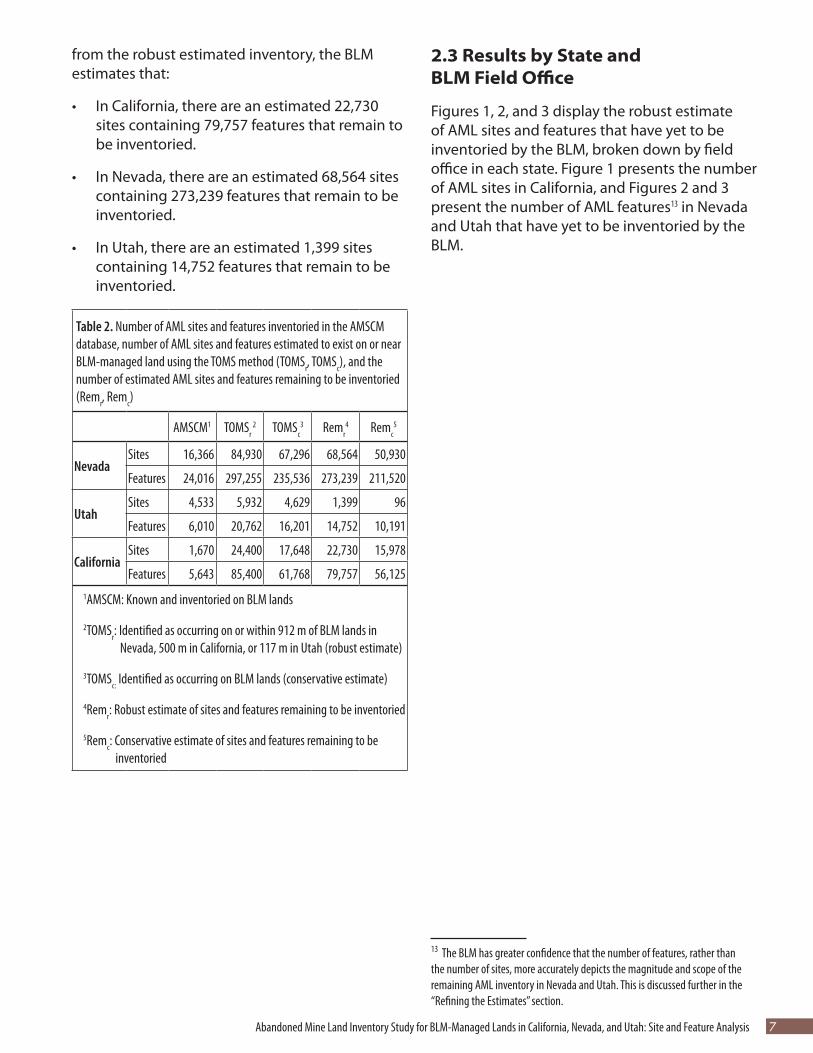
from the robust estimated inventory, the BLM estimates that:
• In California, there are an estimated 22,730 sites containing 79,757 features that remain to be inventoried.
• In Nevada, there are an estimated 68,564 sites containing 273,239 features that remain to be inventoried.
• In Utah, there are an estimated 1,399 sites containing 14,752 features that remain to be inventoried.
Table 2. Number of AML sites and features inventoried in the AMSCM database, number of AML sites and features estimated to exist on or near BLM-managed land using the TOMS method (TOMSr, TOMSc), and the number of estimated AML sites and features remaining to be inventoried (Remr, Remc)
AMSCM1 TOMSr 2 TOMSc
3 Remr4 Remc
5
NevadaSites 16,366 84,930 67,296 68,564 50,930
Features 24,016 297,255 235,536 273,239 211,520
UtahSites 4,533 5,932 4,629 1,399 96
Features 6,010 20,762 16,201 14,752 10,191
CaliforniaSites 1,670 24,400 17,648 22,730 15,978
Features 5,643 85,400 61,768 79,757 56,125
1AMSCM: Known and inventoried on BLM lands
2TOMSr: Identified as occurring on or within 912 m of BLM lands in Nevada, 500 m in California, or 117 m in Utah (robust estimate)
3TOMSc: Identified as occurring on BLM lands (conservative estimate)
4Remr: Robust estimate of sites and features remaining to be inventoried
5Remc: Conservative estimate of sites and features remaining to be inventoried
2.3 Results by State and BLM Field Office
Figures 1, 2, and 3 display the robust estimate of AML sites and features that have yet to be inventoried by the BLM, broken down by field office in each state. Figure 1 presents the number of AML sites in California, and Figures 2 and 3 present the number of AML features13 in Nevada and Utah that have yet to be inventoried by the BLM.
13 The BLM has greater confidence that the number of features, rather than the number of sites, more accurately depicts the magnitude and scope of the remaining AML inventory in Nevada and Utah. This is discussed further in the “Refining the Estimates” section.

Abandoned Mine Land Inventory Study for BLM-Managed Lands in California, Nevada, and Utah: Site and Feature Analysis8
Figure 1. Robust estimate of remaining AML sites to be inventoried on BLM land in California, broken down by field office.

Abandoned Mine Land Inventory Study for BLM-Managed Lands in California, Nevada, and Utah: Site and Feature Analysis 9
Figure 2. Robust estimate of remaining AML features to be inventoried on BLM land in Nevada, broken down by field office. Features are used instead of sites for Nevada. For further details, see the section titled “Refining the Estimates.”

Abandoned Mine Land Inventory Study for BLM-Managed Lands in California, Nevada, and Utah: Site and Feature Analysis10
Figure 3. Robust estimate of remaining AML features to be inventoried on BLM land in Utah, broken down by field office. Features are used instead of sites for Utah. For further details, see the section titled “Refining the Estimates.”

Abandoned Mine Land Inventory Study for BLM-Managed Lands in California, Nevada, and Utah: Site and Feature Analysis 11
3. Estimating Time and Cost to Complete the AML Inventory and Address the Remaining Physical Safety Hazards
3.1 Estimated Time to Complete the AML Inventory
The number of estimated AML sites and features that remain to be inventoried provides a basis for calculating the amount of time it may take to field validate each of the symbols. The BLM estimates that 35 features (or 10 mine symbols) can be field validated in a week. Based on the robust estimate of AML sites and features that remain to be inventoried, it will take a field team of two AML specialists:
• In California, 568 work months to complete the estimated inventory by validating the mine symbols.14
• In Nevada, 1,952 work months to complete the estimated inventory by validating the mine symbols. 15
• In Utah, 105 work months to complete the estimated inventory by validating the mine symbols.16
Based on these estimates, it would require a total of 2,625 work months to validate the mine symbols in these three states. This workload distributed over 10 two-person field crews would require approximately 20 years to complete.
3.2 Estimated Costs to Complete the AML Inventory
In July 2013, the BLM Abandoned Mine Lands Program published the “Feasibility Study for AML Inventory Validation and Physical Safety Closures.” In this feasibility study, the Abandoned Mine
14 22,730 sites divided by 10 sites per week = 2,273 weeks; 2,273 weeks divided by 4 weeks per work month15 273,239 features divided by 35 features per week = 7,807 weeks; 7,807 weeks divided by 4 weeks per work month16 14,752 features divided by 35 features per week = 421 weeks; 421 weeks divided by 4 weeks per work month
Lands Program estimated the costs for validating future AML sites in each state where the BLM manages land. In the report, the BLM presents the cost for field validating a mine site:
• In California, it will cost $5,200 to field validate a mine site.
• In Nevada, it will cost $1,100 to field validate a mine site.
• In Utah, it will cost $1,800 to field validate a mine site.
Using these cost values and the robust estimate of AML sites that remain to be inventoried, it will require approximately $212 million to field validate the estimated remaining AML sites in California, Nevada, and Utah. State by state, it will require:
• In California, approximately $118 million to field validate the estimated remaining AML sites.
• In Nevada, approximately $86 million to field validate the estimated remaining AML sites.17
• In Utah, approximately $8 million to field validate the estimated remaining AML sites.
3.3 Estimated Costs to Address Remaining Physical Safety Hazards
During field validation of the mine symbols, the California AMLU observed that approximately 84 percent of the sites contain features that pose physical safety hazards. Further, 38 percent of the features present at the field validated sites were hazardous openings (i.e., shafts, adits, or other openings that are large and deep enough to
17 Values of 78,068 sites (273,239 features divided by 3.5 features per site) in Nevada and 4,214 sites (14,752 features divided by 3.5 features per site) were used to calculate this amount. This concept is explained further in the section “Refining the Estimates.”
17

Abandoned Mine Land Inventory Study for BLM-Managed Lands in California, Nevada, and Utah: Site and Feature Analysis12
endanger human life).18 Based on these statistics and the robust subset, on BLM land in California there are approximately:
• 19,093 sites remaining to be inventoried that pose physical safety hazards.
• 30,308 features that are hazardous openings.
Similar field validated statistics concerning physical safety hazards do not currently exist for Nevada and Utah. Thus, physical safety hazard estimates are not calculated for Nevada or Utah.
18 Department of Conservation, “California’s Abandoned Mines: A Report on the Magnitude and Scope of the Issue in the State, Volume I” (California: California Department of Conservation, Office of Mine Reclamation, 2003); and California Department of Conservation, “California’s Abandoned Mine Lands Program Fact Sheet” (California: California Department of Conservation, Office of Mine Reclamation, January 2012).
In the July 2013 publication, “Feasibility Study for AML Inventory Validation and Physical Safety Closures,” the BLM also estimated the future cost of remediating the physical safety hazards in California at $19,400 per physical safety hazard remediation. With an estimated total of 30,308 remaining features in California that pose physical safety hazards, it will require approximately $588 million to remediate them.

Abandoned Mine Land Inventory Study for BLM-Managed Lands in California, Nevada, and Utah: Site and Feature Analysis 13
4. Refining the Estimates
The BLM has confidence that the estimates of the total and remaining AML sites and features presented in this document adequately depict the scope and magnitude of the inventory work remaining to be performed by the Abandoned Mine Lands Program. However, the BLM believes that the actual values of the estimates presented in this document will become more refined as more sites (symbols) are field validated.
More than 3,000 of the mine symbols have been field validated by the California AMLU and used to record AML sites in their inventory database. However, field validation of mine symbols has not yet occurred in Nevada or Utah. As mine symbols are validated, the accuracy and confidence in the estimates will increase, especially for those in Nevada and Utah.
4.1 Refining the California Estimates
Of the three states, the BLM has the most confidence in the estimates of the remaining AML sites and features for California based on the extensive field validation by the California AMLU. As more symbols are validated, the site to feature ratio may vary if there are differences in the site to feature ratio at the additional symbols.
4.2 Refining the Nevada Estimates
The BLM has not yet validated the mine symbols in Nevada. As such, the California metrics of 1 symbol equaling 1 AML site and 3.5 AML features were used. The BLM has a reasonable degree of confidence that its application of the California statistics to the Nevada mine symbol data has adequately estimated the scope and magnitude of the AML sites and features that remain to be inventoried.
When 1 percent, or approximately 850, of the mine symbols are validated in Nevada, a Nevada-specific features per mine symbol ratio can be used to calculate and refine the total amount of
estimated AML sites and features (instead of the California ratio of 3.5 features per symbol).
Further, the application of the term “site” can vary from state to state. Based on AMSCM data, Nevada reports that half of the sites contain only one feature. Because the application of the term “feature” is consistent between both the AMSCM data and the mining symbol statistics (i.e., a single manmade disturbance associated with mining activity), the BLM has confidence that the features more accurately depict the scope and magnitude of the total and remaining AML inventory work in this state.
4.3 Refining the Utah Estimates
Like Nevada, the BLM has not yet validated the mine symbols in Utah. California metrics of 1 symbol equaling 1 AML site and 3.5 AML features were used. The BLM has a reasonable degree of confidence that its application of the California statistics to the Utah mine symbol data has adequately estimated the scope and magnitude of the AML sites and features that remain to be inventoried.
When 5 percent, or approximately 300, of the mine symbols are validated in Utah, a Utah-specific features per mine symbol ratio can be used to calculate and refine the total amount of estimated AML sites and features (instead of the California ratio of 3.5 features per symbol).
The application of the term “site” can vary from state to state. Based on AMSCM data, Utah reports that two out of three sites contain only one feature. Because the application of the term “feature” is consistent between both the AMSCM data and the mining symbol statistics (i.e., a single manmade disturbance associated with mining activity), the BLM has confidence that the features more accurately depict the scope and magnitude of the total and remaining AML inventory work in this state.

Abandoned Mine Land Inventory Study for BLM-Managed Lands in California, Nevada, and Utah: Site and Feature Analysis14
5. Limitations
While the mine symbols provide a good starting point for estimating the magnitude and scope of the estimated AML inventory at a state level, this approach can be less successful when analyzed at a local or field office level. For example, in Figure 3 (the map of remaining AML features in Utah), some field offices exhibit a negative number of remaining features. This occurs when the number of features recorded in the AMSCM database exceeds the number of estimated AML features from mine symbols for that geographic area.
Additionally, the mine symbols are not assumed to provide a comprehensive data source for all mining locations in a state. Other data sources (e.g., mining district mineral reports) and field investigations will be required to eventually document all AML sites and features on BLM-managed land. However, the mine symbols provide locational data to potentially save time in field validation and improve the known BLM AML inventory.

Abandoned Mine Land Inventory Study for BLM-Managed Lands in California, Nevada, and Utah: Site and Feature Analysis 15
6. Expanding the Study to Other States
In order to estimate the number of AML sites and features for the remaining states where the BLM manages land, a mining symbol dataset of sufficient quality must exist and be available. To date, the BLM has identified acceptable datasets for only California, Nevada, and Utah. However, the USGS, in partnership with the BLM and University of Wisconsin-Madison, began a project in 2012 to complete a mine symbol dataset for the nation.19 Upon completion of this project, AML site and feature estimates for the other states where the BLM manages land can be calculated.
19 Gregory Fernette (principal investigator), “Development of Enhanced Feature Recognition Software for the Extraction of Mine Features from USGS Topographic Maps” (project) (U.S. Geological Survey, Mineral Resource Program, 2013) http://www.usgs.gov/cdi/year/2013.html.
BLM-managed lands

Abandoned Mine Land Inventory Study for BLM-Managed Lands in California, Nevada, and Utah: Site and Feature Analysis16
7. Conclusion
Using the USGS symbol approach greatly improves the BLM’s ability to build a current, complete, and accurate database of AML sites and features. This is critical to measuring progress and reporting comprehensive results of program activities. Through field validation of the mine symbols, the BLM can inspect suspected AML sites and take appropriate action to mitigate hazards.
The BLM currently estimates that the total cost of field validating and recording in the AMSCM
database the estimated remaining 93,000 sites and 368,000 features in California, Nevada, and Utah to be approximately $212 million (see Table 3 for overall summary). This would require 10 two-person teams approximately 20 years to complete. In California alone, there are an estimated 30,308 features that pose physical safety hazards requiring $588 million to remediate.
Table 3. Overall summary of the estimated number of sites and features remaining to be inventoried on BLM lands in California, Nevada, and Utah and the estimated time and cost to complete the inventory
Estimated Number of Sites
to be Inventoried
Estimated Number of Features
to be Inventoried
Estimated Time to Complete
Inventory
Estimated Cost to Complete Inventory
California 22,730 79,757 568 work months $118 million
Nevada 68,564 273,239 1,952 work months $86 million
Utah 1,399 14,752 105 work months $8 million
Total 92,693 367,748 20 years1 $212 million
1 This inventory time is based on 10 two-person work crews.