
A63 Castle Street improvements - Highways England ... A63 Castle Street improvements A63 Castle...
11
A63 Castle Street improvements Public consultation January 2017
Transcript of A63 Castle Street improvements - Highways England ... A63 Castle Street improvements A63 Castle...
A63 Castle Street improvementsPublic consultation January 2017
A63 Castle Street improvements 3A63 Castle Street improvements2
Highways England is proposing to relieve congestion and provide better access to the Port of Hull by improving the A63 Castle Street. This 0.9 mile stretch of dual carriageway between Ropery Street and the Market Place/Queen Street junction carries around 45,000 vehicles per day and as a result, the road suffers from congestion, particularly at peak times.The A63 acts as a barrier between the city centre to the north and the leisure facilities and dock areas to the south. Our proposed improvements will create a better connection between the two areas and once completed, the scheme will also improve safety for road users and the local community.
In 2013, a consultation exercise was held which presented our proposed road improvements in more detail. Since 2013, we have taken on board your comments and undertaken additional environmental and traffic assessments to ensure our plans are robust.
We are consulting again to obtain your views on the changes we have made since 2013. As four years have elapsed we are taking the opportunity to re-consult on our proposals in case your views have changed.
We are required to make an application for a Development Consent Order (DCO) under the Planning Act 2008. This is submitted to the Planning Inspectorate who will examine the application and make a recommendation to the Secretary of State for Transport, who makes the decision on whether the Development Consent Order should be granted.
Based on the consultation outcome, we will submit an application in spring 2017.
On acceptance of the application and prior to commencing the examination, the Planning Inspectorate will seek the views of statutory consultees and there is an opportunity (minimum of 28 days) for local community members to register as an interested party via the Planning Inspectorate website: www.infrastructure.planninginspectorate.gov.uk
Following the examination, the Planning Inspectorate will present its recommendation to the Secretary of State, who has the final decision on whether the Development Consent Order is granted.
Introduction
Pre-application Acceptance Pre-examination Examination Decision Post-decision
View our proposals
Attend our consultation events
Provide your comments by 13 February 2017
The Planning Inspectorate has 28 days to decide whether the application meets the required standards to proceed, including whether our consultation has been adequate
You can register with the Planning Inspectorate as an interested party in order to be kept informed of progress and opportunities to be involved. The Planning Inspectorate will set timescales
The Planning Inspectorate has 6 months to carry out an examination
Registered parties can send written comments to the Planning Inspectorate
They can ask to speak at a public hearing
The Planning Inspectorate will make a recommendation to the relevant Secretary of State within 3 months. The Secretary of State then has a further 3 months to issue a decision
There is the opportunity for legal challenge
The Planning Act 2008 process for the nationally significant infrastructure projects
How you can be involved
A63 Castle Street improvements 5A63 Castle Street improvements4
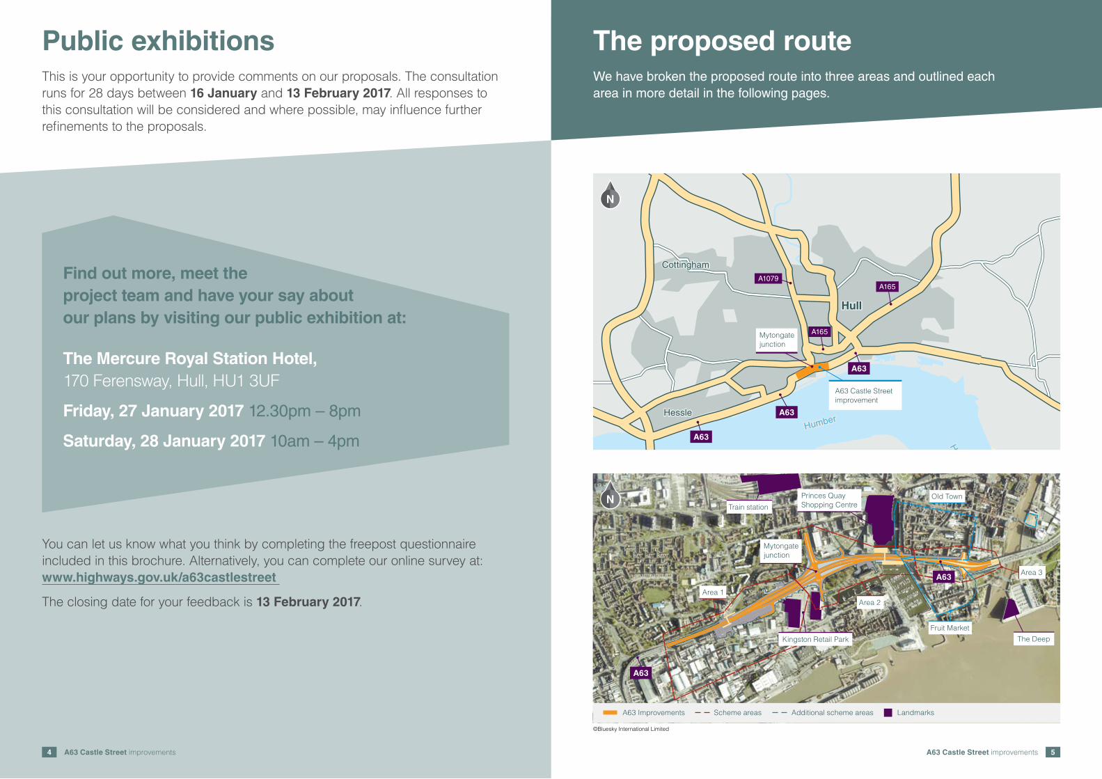
The proposed route
A63 Improvements Scheme areas Additional scheme areas Landmarks
N
The DeepKingston Retail Park
Princes QuayShopping CentreTrain station
Area 1Area 2
Area 3
Old Town
Fruit Market
A63
A63
Mytongatejunction
HullHull
HessleHessle
CottinghamCottingham
Humber BridgeHumber Bridge
Hum
ber
Hum
ber
Humber Humber
A63
A63
A63
A1079
A165
A165
Mytongatejunction
A63 Castle Streetimprovement
N
You can let us know what you think by completing the freepost questionnaire included in this brochure. Alternatively, you can complete our online survey at: www.highways.gov.uk/a63castlestreet
The closing date for your feedback is 13 February 2017.
The Mercure Royal Station Hotel, 170 Ferensway, Hull, HU1 3UF
Friday, 27 January 2017 12.30pm – 8pm
Saturday, 28 January 2017 10am – 4pm
Find out more, meet the project team and have your say about our plans by visiting our public exhibition at:
Public exhibitionsWe have broken the proposed route into three areas and outlined each area in more detail in the following pages.
This is your opportunity to provide comments on our proposals. The consultation runs for 28 days between 16 January and 13 February 2017. All responses to this consultation will be considered and where possible, may influence further refinements to the proposals.
©Bluesky International Limited

A63 Castle Street improvements 7A63 Castle Street improvements6
Preferred pumpingstation location
Alternative pumpingstation location
Trinity Burial Ground
A63 lowered by approx. 7m
Princes Quay footbridge
Relocation ofSpurn Lightship
Junctionclosed
New bridge to carryFerensway overthe A63
N
A63 Improvements Landmarks
Myton S
treetM
yton Street
Roper Street
Roper Street
Wat
erho
use
Lane
Wat
erho
use
Lane
Kingston Street
Kingston Street
Railw
ay Street
Railw
ay Street
Princes QuayShopping Centre
St James Street closed
William Street andCogan Street closed
New restricted access
Proposed Porter Streetfootbridge
Lister StreetLister Street
English Street
English Street
Walker StreetWalker Street
Wal
ker
Str
eet
Wal
ker
Str
eet
Porte
r Stre
et
Porte
r Stre
et William StreetWilliam Street
Kingston Retail Park
Demolition of MytonCentre and proposedpublic open space
N
A63 Improvements Proposed public open space Landmarks
What we propose to do
Close the junction with St James Street in order to provide a safe and free flowing road layout.
Replace the signal controlled pedestrian crossing with a new bridge over the A63 near Porter Street in order to maintain access across the A63 for pedestrians, cyclists and disabled users.
Provide restricted access for Arco via Spruce Road to improve local traffic movements.
Re-configure Arco car park and create a new access from St James Street.
Close William Street/Cogan Street to through traffic to provide land to build the scheme.
Reconfigure Kingston Retail Park car park to reduce the loss of parking spaces.
What we propose to do
Provide a split level junction at Mytongate to separate A63 traffic and local traffic.
Lower the A63 and provide a new Mytongate bridge to carry Ferensway/Commercial Road traffic over the A63.
Provide a combined pedestrian, cyclist and disabled user route across the A63 on both sides of the new Mytongate bridge.
Close the direct access to the Holiday Inn from the A63 to provide land to build the scheme.
Provide a new pumped rising main to remove surface water which flows into the underpass at Mytongate (further details on page 14).
Changes since last public consultation in 2013
The scheme has been extended westwards from St James Street to Redfern Close/Ropery Street to provide safer road marking arrangements between the existing and new road layouts.
Parking restrictions have been introduced on St James Street on the approach to the junction with English Street to assist traffic using the junction.
To replace the existing amenity area in Trinity Burial Ground (see Area 2 map) which is required to build the scheme, we will be providing an equivalent area of replacement public open space. There are two options under consideration:
� Demolishing the Myton Centre and converting the area into public open space (shown in map above)
� A development located east of the River Hull and north of the Scale Lane bridge approach ramp (see Area 3 map)
Changes since last public consultation in 2013
An additional lane has been added to the eastbound on slip road linking Mytongate junction to Myton Street. This will improve traffic flow through the new junction.
The proposed location for the drainage outfall pumping station has moved. It will not be located at a low level in the new underpass. This has removed the requirement for a maintenance layby in the new underpass.
We are considering the demolition of the Grade II listed Earl de Grey public house and Castle Buildings so the scheme can be constructed safely.
Area 1 – West of Mytongate junction Area 2 – Mytongate junction
A63 Castle Street improvements 9A63 Castle Street improvements8
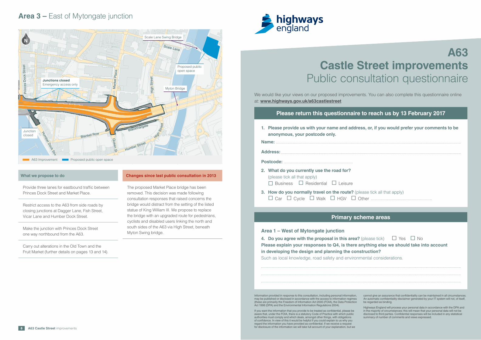
What we propose to do
Provide three lanes for eastbound traffic between Princes Dock Street and Market Place.
Restrict access to the A63 from side roads by closing junctions at Dagger Lane, Fish Street, Vicar Lane and Humber Dock Street.
Make the junction with Princes Dock Street one way northbound from the A63.
Carry out alterations in the Old Town and the Fruit Market (further details on pages 13 and 14).
Changes since last public consultation in 2013
The proposed Market Place bridge has been removed. This decision was made following consultation responses that raised concerns the bridge would distract from the setting of the listed statue of King William III. We propose to replace the bridge with an upgraded route for pedestrians, cyclists and disabled users linking the north and south sides of the A63 via High Street, beneath Myton Swing bridge.
Area 3 – East of Mytongate junction
1. Please provide us with your name and address, or, if you would prefer your comments to be anonymous, your postcode only.
Name:
Address:
Postcode:
2. What do you currently use the road for? (please tick all that apply)
Business Residential Leisure
3. How do you normally travel on the route? (please tick all that apply) Car Cycle Walk HGV Other
A63Castle Street improvements
Public consultation questionnaireWe would like your views on our proposed improvements. You can also complete this questionnaire online at: www.highways.gov.uk/a63castlestreet
Information provided in response to this consultation, including personal information, may be published or disclosed in accordance with the access to information regimes (these are primarily the Freedom of Information Act 2000 (FOIA), the Data Protection Act 1998 (DPA) and the Environmental Information Regulations 2004).
If you want the information that you provide to be treated as confidential, please be aware that, under the FOIA, there is a statutory Code of Practice with which public authorities must comply and which deals, amongst other things, with obligations of confidence. In view of this it would be helpful if you could explain to us why you regard the information you have provided as confidential. If we receive a request for disclosure of the information we will take full account of your explanation, but we
cannot give an assurance that confidentiality can be maintained in all circumstances. An automatic confidentiality disclaimer generated by your IT system will not, of itself, be regarded as binding.
Highways England will process your personal data in accordance with the DPA and in the majority of circumstances; this will mean that your personal data will not be disclosed to third parties. Confidential responses will be included in any statistical summary of number of comments and views expressed.
Please return this questionnaire to reach us by 13 February 2017
Area 1 – West of Mytongate junction
4. Do you agree with the proposal in this area? (please tick) Yes NoPlease explain your responses to Q4, is there anything else we should take into account in developing the design and planning the construction? Such as local knowledge, road safety and environmental considerations.
Primary scheme areas
Myton Bridge
Scale Lane Swing Bridge
BlackfriargateBlackfriargate
Blanket RowBlanket Row
Humber Street
Humber Street
Hum
ber Dock S
treet
Hum
ber Dock S
treet
Hig
h S
tree
tH
igh
Str
eet
Mar
ket P
lace
Mar
ket P
lace
Scale LaneScale Lane
Pri
nces
Do
ck S
tree
tP
rinc
es D
ock
Str
eet
A63 Improvement Proposed public open space
Queen S
tQ
ueen St
High
Str
ee
t
High
Str
ee
t
Junctionclosed
N
Junctions closedEmergency access only
Proposed publicopen space
A63 Castle Street improvements 11A63 Castle Street improvements10
Area 2 – Mytongate junction
5. Do you agree with the proposal in this area? (please tick) Yes NoPlease explain your responses to Q5, is there anything else we should take into account in developing the design and planning the construction? Such as local knowledge, road safety and environmental considerations.
Area 3 – East of Mytongate junction
6. Do you agree with the proposal in this area? (please tick) Yes NoPlease explain your responses to Q6, is there anything else we should take into account in developing the design and planning the construction? Such as local knowledge, road safety and environmental considerations.
Traffic management
7. Do you agree with the proposals to prohibit right turns to traffic at Mytongate junction? (please tick) Yes No
Please explain your response:
Trinity Burial Ground
8. We will need to excavate at Trinity Burial Ground and in doing this we can learn a lot about people who lived in Hull more than 200 years ago. What would you most like to know about them? (please tick)
Origins – where people came from and how does it reflect the community of Hull today. Health – how healthy was the community and how has that changed across different groups such as age compared with today? Social history – What kind of jobs did people have, how did they live and what did they believe?
Any other ideas?
Additional scheme areas
Rising main
9. Do you agree with the proposals for the route of the rising main? (please tick) Yes No Do you have any comments on either of the options?
10. Do you agree with the proposed location of the pumping station? (please tick) Yes No Do you have any comments on either of the options?
Old Town
11. Do you agree with the proposals for traffic through the old town of Hull? (please tick) Yes No Please explain your response:
12. Please use this space to provide any further comments or suggestions:
Please help us understand the range of people we are consulting by completing the following section. This information will not be used for any other purpose.
13. Age: 16–24 25–34 35–44 45–54 55–64 65+
14. Gender: Male Female Prefer not to say
15. Do you consider yourself to have a disability? (please tick) Yes No Prefer not to say
16. Did you attend a consultation event? (please tick) Yes No
17. By completing this questionnaire, you have identified that you have an interest in this project. It would help us if you could identify the nature of your interest. (You may tick more than one box)
Business Local business Residential Agricultural interest Public Rights of Way Leisure Other
Additional comments and information
A63 Castle Street improvements 13
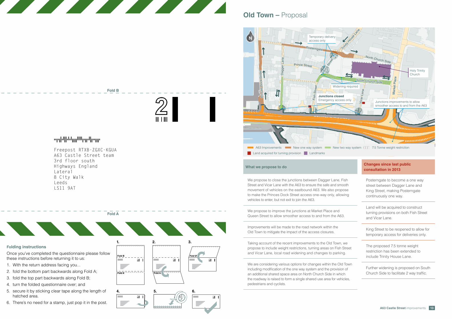
What we propose to do
We propose to close the junctions between Dagger Lane, Fish Street and Vicar Lane with the A63 to ensure the safe and smooth movement of vehicles on the eastbound A63. We also propose to make the Princes Dock Street access one-way only, allowing vehicles to enter, but not exit to join the A63.
We propose to improve the junctions at Market Place and Queen Street to allow smoother access to and from the A63.
Improvements will be made to the road network within the Old Town to mitigate the impact of the access closures.
Taking account of the recent improvements to the Old Town, we propose to include weight restrictions, turning areas on Fish Street and Vicar Lane, local road widening and changes to parking.
We are considering various options for changes within the Old Town including modification of the one way system and the provision of an additional shared space area on North Church Side in which the roadway is raised to form a single shared use area for vehicles, pedestrians and cyclists.
Old Town – Proposal
PosterngatePosterngate
Dag
ger
Lan
eD
agg
er L
ane
Vic
ar L
ane
Vic
ar L
ane
Fis
h S
tree
tF
ish
Str
eet
Trin
ity H
ouse
Lan
e
Trin
ity H
ouse
Lan
e
Pri
nces
Do
ck S
tree
tP
rinc
es D
ock
Str
eet
Mar
ket P
lace
Mar
ket P
lace
North Church Side
North Church Side
South Church SideSouth Church Side
Prince StreetPrince StreetHoly TrinityChurch
Temporary deliveryaccess only
Junctions improvements to allowsmoother access to and from the A63
Widening required
King
Stre
et
King
Stre
et
A63 Improvements New one way system New two way system
Landmarks
7.5 Tonne weight restriction
Land acquired for turning provision
N
Junctions closedEmergency access only
Fold B
Fold A
Fold B
Fold A
TTDTTDFAFDFFTADDTTAFFTDDADTFTTDTFFDA
Fold B
Fold A
1. 2. 3.
4. 5. 6.
Folding instructions
Once you’ve completed the questionnaire please follow these instructions before returning it to us:
1. With the return address facing you...
2. fold the bottom part backwards along Fold A;
3. fold the top part backwards along Fold B;
4. turn the folded questionnaire over; and
5. secure it by sticking clear tape along the length of hatched area.
6. There’s no need for a stamp, just pop it in the post.
TTDTDFTAFFTATADDDDAAAADTDDTAFDTTDDDT
TTDTTDFAFDFFTADDTTAFFTDDADTFTTDTFFDA
TTDTTDFAFDFFTADDTTAFFTDDADTFTTDTFFDA TTDTTDFAFDFFTADDTTAFFTDDADTFTTDTFFDA
TTDTTDFAFDFFTADDTTAFFTDDADTFTTDTFFDA TTDTTDFAFDFFTADDTTAFFTDDADTFTTDTFFDA
Freepost RTXB-ZGXC-KGUAA63 Castle Street team3rd floor southHighways EnglandLateral8 City WalkLeedsLS11 9AT
Changes since last public consultation in 2013
Posterngate to become a one way street between Dagger Lane and King Street, making Posterngate continuously one way.
Land will be acquired to construct turning provisions on both Fish Street and Vicar Lane.
King Street to be reopened to allow for temporary access for deliveries only.
The proposed 7.5 tonne weight restriction has been extended to include Trinity House Lane.
Further widening is proposed on South Church Side to facilitate 2 way traffic.

A63 Castle Street improvements 15A63 Castle Street improvements14
HullHull
HessleHessle
CottinghamCottingham
Hum
ber
Hum
ber
Humber Humber
A63
A63
A63
A1079
A165
A165
Blackfriargate Bonus Site
Tower Street Wharf (north)temporary compound andcreation of public open space
Tower Street Wharf (south)
Wellington StreetIsland Wharf
Demolition of Myton Centreand creation of publicopen space Waterhouse Lane
Coach Park
Land south east ofMytongate junction
A63 eastbound laybynorth of St Andrews Quay
Neptune Street SouthAMI Cold Stores
Saxon Way
Livingstone RoadSouth HumberProperties Ltd. A63
A63A63
A63
N
N
N N
N N
Site compounds – Proposal
We are considering using a number of vacant development plots as offices and equipment stores for the work and will be including the sites listed below in the Development Consent Order
Vacant land east of River Hull Land south-east of Mytongate junction
Car park east of River Hull Land south of Neptune Street
Bonus site south of Blackfriargate Layby on A63
Site south of Wellington Street West Commercial site south of A63 and east of Hessle Haven
Blanket RowBlanket Row
Humber Street
Humber Street
Pier S
treetP
ier Street
Queen S
treetQ
ueen Street
Hum
ber
Place
Hum
ber
Place
Hum
ber Dock S
treet
Hum
ber Dock S
treet
Wellington Street
Wellington Street
Wideningrequired
No parking zone
Approx. boundaryof Fruit Marketdevelopment
Permit holdersparking only
High
Str
ee
t
High
Str
ee
t
A63 Improvements New one way system Permit holders only 18 Tonne weight restriction
N
Junction closed
A drainage outfall is required for surface water which flows into the underpass at Mytongate. This water will either be pumped into the existing Yorkshire Water network (option 2) or it will be pumped into the River Humber via a dedicated rising main which will be installed in Commercial Road, Manor House Street, Wellington Street West and through private land to the river (option 1).
Since the 2013 consultation we have discounted the route in Kingston Street and Railway Street.
The preferred location for the pumping station is west of Trinity Burial Ground but we are also considering an alternative location adjacent to the westbound off slip road.
Fruit Market – Proposal
Drainage outfall – Proposal
What we propose to do
Closure of the Humber Dock Street junction with the A63 Castle Street.
Option 1 Option 2 Discounted option
Kingston Street
Kingston Street
Wellington Street West
Wellington Street West
Manor H
ouse Street
Manor H
ouse Street
Railw
ay Street
Railw
ay Street
Preferred pumpingstation location
Alternative pumpingstation location
We have taken into consideration the planned changes to the Fruit Market area.
Changes since last public consultation in 2013
The addition of an 18 tonne weight restriction along Humber Dock Street, Blanket Row, Humber Street and Pier Street.
Some carriageway widening at Humber Dock Street and Blanket Row junction.
Some parking changes and road widening on Humber Dock Street and Blanket Row to accommodate the closure of the Humber Dock Street junction with the A63.
A63 Castle Street improvements 17A63 Castle Street improvements16
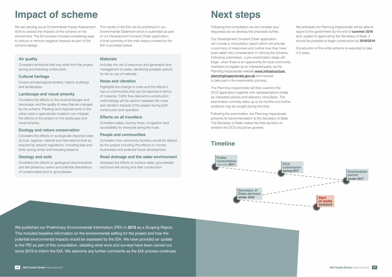
Next stepsFollowing this consultation we will consider your responses as we develop the proposals further.
Our Development Consent Order application will include a consultation report which will provide a summary of responses and outline how they have been taken into consideration in refining the scheme. Following submission, a pre-examination stage will begin, when there is an opportunity for local community members to register as an interested party via the Planning Inspectorate website www.infrastructure.planninginspectorate.gov.uk and request to take part in the examination process.
The Planning Inspectorate will then examine the DCO application together with representations made by interested parties and statutory consultees. The examination normally takes up to six months and further evidence may be sought during this time.
Following the examination, the Planning Inspectorate presents its recommendation to the Secretary of State. The Secretary of State makes the final decision on whether the DCO should be granted.
We anticipate the Planning Inspectorate will be able to report to the government by the end of summer 2018 and, subject to approval by the Secretary of State, it should be possible to begin construction by 2018/2019.
Construction of the entire scheme is expected to take 3-5 years.
Impact of schemeWe are carrying out an Environmental Impact Assessment (EIA) to assess the impacts of the scheme on the environment. The EIA process includes considering ways to reduce or remove negative impacts as part of the scheme design.
The results of the EIA will be published in our Environmental Statement which is submitted as part of our Development Consent Order application. A brief summary of the main topics covered by the EIA is provided below:
Air qualityConsiders emissions that may arise from the project during and following construction.
Cultural heritageCovers archaeological remains, historic buildings and landscapes.
Landscape and visual amenityConsiders the effects on the local landscape and townscape, and the quality of views that are changed by the scheme. Planting and improvements to the urban area in appropriate locations can mitigate the effects of the project on the landscape and visual amenity.
Ecology and nature conservationConsiders the effects on ecologically important sites at local, regional, national and international level as required by relevant regulations, including bats and birds during winter and breeding seasons.
Geology and soilsConsiders the effects on geological resources/soils and the presence, extent and potential disturbance of contaminated land or groundwater.
MaterialsIncludes the use of resources and generation and management of waste, identifying possible options for the re-use of materials.
Noise and vibrationHighlights the change in noise and the effects it has on communities that can be reported in terms of nuisance. Traffic flow data and a construction methodology will be used to reassess the noise and vibration impacts of the project during both construction and operation.
Effects on all travellersConsiders safety, journey times, congestion and accessibility for everyone along the route.
People and communitiesConsiders how community facilities would be altered by the project including the effects on homes, businesses and potential future development.
Road drainage and the water environmentAssesses the effects on surface water, groundwater and flood risk during and after construction.
We published our Preliminary Environmental Information (PEI) in 2013 as a Scoping Report.
This included baseline information on the environmental setting for the project and how the
potential environmental impacts would be assessed by the EIA. We have provided an update
to the PEI as part of this consultation, detailing what work and surveys have been carried out
since 2013 to inform the EIA. We welcome any further comments as the EIA process continues.
Examinationperiod
PublicconsultationJanuary 2017 DCO
submissionspring 2017
winter 2017
winter 2018
Secretary ofState decision
Startof works2018/2019
Timeline
A63 Castle Street improvements 19A63 Castle Street improvements18
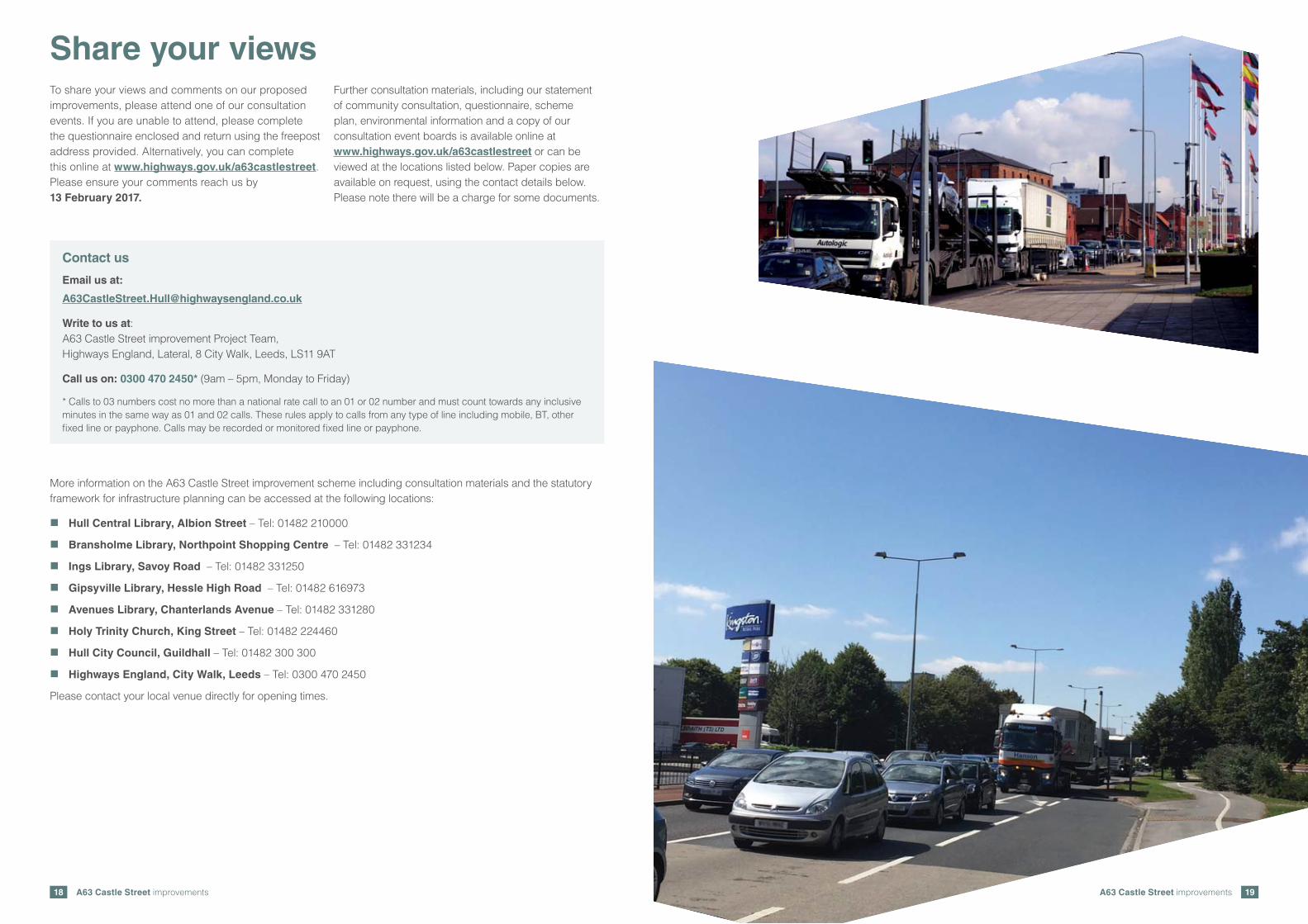
Share your viewsTo share your views and comments on our proposed improvements, please attend one of our consultation events. If you are unable to attend, please complete the questionnaire enclosed and return using the freepost address provided. Alternatively, you can complete this online at www.highways.gov.uk/a63castlestreet. Please ensure your comments reach us by 13 February 2017.
Further consultation materials, including our statement of community consultation, questionnaire, scheme plan, environmental information and a copy of our consultation event boards is available online at www.highways.gov.uk/a63castlestreet or can be viewed at the locations listed below. Paper copies are available on request, using the contact details below. Please note there will be a charge for some documents.
More information on the A63 Castle Street improvement scheme including consultation materials and the statutory framework for infrastructure planning can be accessed at the following locations:
� Hull Central Library, Albion Street – Tel: 01482 210000
� Bransholme Library, Northpoint Shopping Centre – Tel: 01482 331234
� Ings Library, Savoy Road – Tel: 01482 331250
� Gipsyville Library, Hessle High Road – Tel: 01482 616973
� Avenues Library, Chanterlands Avenue – Tel: 01482 331280
� Holy Trinity Church, King Street – Tel: 01482 224460
� Hull City Council, Guildhall – Tel: 01482 300 300
� Highways England, City Walk, Leeds – Tel: 0300 470 2450
Please contact your local venue directly for opening times.
Contact us
Email us at:
Write to us at: A63 Castle Street improvement Project Team, Highways England, Lateral, 8 City Walk, Leeds, LS11 9AT
Call us on: 0300 470 2450* (9am – 5pm, Monday to Friday)
* Calls to 03 numbers cost no more than a national rate call to an 01 or 02 number and must count towards any inclusive minutes in the same way as 01 and 02 calls. These rules apply to calls from any type of line including mobile, BT, other fixed line or payphone. Calls may be recorded or monitored fixed line or payphone.

If you need help accessing this or any other Highways England information,please call 0300 123 5000 and we will help you.
© Crown copyright 2016.You may re-use this information (not including logos) free of charge in any format or medium, under the terms of the Open Government Licence. To view this licence: visit www.nationalarchives.gov.uk/doc/open-government-licence/write to the Information Policy Team, The National Archives, Kew, London TW9 4DU,or email [email protected].
This document is also available on our website at www.gov.uk/highways
If you have any enquiries about this publication email [email protected] call 0300 123 5000*. Please quote the Highways England publications code PR153/16.
Highways England creative job number N160271.
*Calls to 03 numbers cost no more than a national rate call to an 01 or 02 number and must count towards any inclusive minutes in the same way as 01 and 02 calls.These rules apply to calls from any type of line including mobile, BT, other fixed line or payphone. Calls may be recorded or monitored.
Printed on paper from well-managed forests and other controlled sources.
Registered office Bridge House, 1 Walnut Tree Close, Guildford GU1 4LZHighways England Company Limited registered in England and Wales number 09346363