A Web-Based Java Framework for Cross-Platform Mobile GIS ... · of cross-platform Mobile GIS...
25
278 GIScience & Remote Sensing, 2005, 42, No. 4, p. 278-302. Copyright © 2005 by V. H. Winston & Son, Inc. All rights reserved. A Web-Based Java Framework for Cross-Platform Mobile GIS and Remote Sensing Applications Ming-Hsiang Tsou, Liang Guo, and Anthony Howser Department of Geography, San Diego State University, San Diego, California 92182 Abstract: A cross-platform Web-based Java development framework for Mobile Geographic Information Systems (Mobile GIS) and remote sensing (RS) applica- tions is introduced for the notebook computer, Pocket PC, and mobile phone plat- forms. Using these platforms, Java software technology is examined for its cross- platform utility in the development of various Mobile GIS and map/image display functions. The three case studies developed with Java 2 Standard Edition (J2SE), Java 2 Micro Edition (J2ME), and Mobile Information Device Profile (MIDP) are examined within the context of mobile GIS. Significant challenges in developing cross-platform Mobile GIS applications are also discussed. These obstacles include heterogeneous operating systems, different wireless communications protocols, low- bandwidth network connections, and the general lack of usability. INTRODUCTION Compared to Desktop Geographic Information Systems (Desktop GIS), Mobile GIS can provide Geographic Information Services (GIServices) in a more portable platform to facilitate field-based data collection and access (Tsou, 2004a). By con- necting to wireless Internet map/image servers and Global Positioning Systems (GPS) data feeds, Mobile GIS devices can display map layers and remotely sensed imagery effectively for various field-based GIS tasks. Many practical field-based GIS applications and tasks require multiple hardware devices for the query and display of spatially associated data. An example scenario may involve delivery truck drivers who require maps of the optimal/shortest routes between their delivery/pickup points. The drivers may wish to display their maps on Pocket PC devices housed in their vehicles. If the drivers are not in their vehicles, they may want to display the same maps on their mobile phones. Furthermore, the drivers may want to generate hard copies of the same maps from their desktop com- puters back in their offices. The requirements for this scenario mandate similar user interface functionality and software interoperability with the map data on all three of the computing platforms. Unfortunately, this kind of interoperability has seldom been investigated. A significant obstacle to creating such a cross-platform map/image query-and-display application is the general lack of software tools that can be used to develop applications for multiple computing platforms.
Transcript of A Web-Based Java Framework for Cross-Platform Mobile GIS ... · of cross-platform Mobile GIS...

278
GIScience & Remote Sensing, 2005, 42, No. 4, p. 278-302.Copyright © 2005 by V. H. Winston & Son, Inc. All rights reserved.
A Web-Based Java Framework for Cross-Platform Mobile GIS and Remote Sensing Applications
Ming-Hsiang Tsou, Liang Guo, and Anthony HowserDepartment of Geography, San Diego State University, San Diego, California 92182
Abstract: A cross-platform Web-based Java development framework for MobileGeographic Information Systems (Mobile GIS) and remote sensing (RS) applica-tions is introduced for the notebook computer, Pocket PC, and mobile phone plat-forms. Using these platforms, Java software technology is examined for its cross-platform utility in the development of various Mobile GIS and map/image displayfunctions. The three case studies developed with Java 2 Standard Edition (J2SE),Java 2 Micro Edition (J2ME), and Mobile Information Device Profile (MIDP) areexamined within the context of mobile GIS. Significant challenges in developingcross-platform Mobile GIS applications are also discussed. These obstacles includeheterogeneous operating systems, different wireless communications protocols, low-bandwidth network connections, and the general lack of usability.
INTRODUCTION
Compared to Desktop Geographic Information Systems (Desktop GIS), MobileGIS can provide Geographic Information Services (GIServices) in a more portableplatform to facilitate field-based data collection and access (Tsou, 2004a). By con-necting to wireless Internet map/image servers and Global Positioning Systems (GPS)data feeds, Mobile GIS devices can display map layers and remotely sensed imageryeffectively for various field-based GIS tasks.
Many practical field-based GIS applications and tasks require multiple hardwaredevices for the query and display of spatially associated data. An example scenariomay involve delivery truck drivers who require maps of the optimal/shortest routesbetween their delivery/pickup points. The drivers may wish to display their maps onPocket PC devices housed in their vehicles. If the drivers are not in their vehicles,they may want to display the same maps on their mobile phones. Furthermore, thedrivers may want to generate hard copies of the same maps from their desktop com-puters back in their offices. The requirements for this scenario mandate similar userinterface functionality and software interoperability with the map data on all three ofthe computing platforms. Unfortunately, this kind of interoperability has seldom beeninvestigated. A significant obstacle to creating such a cross-platform map/imagequery-and-display application is the general lack of software tools that can be used todevelop applications for multiple computing platforms.
WEB-BASED FRAMEWORK 279
Mobile GIS is a relatively new field in geographic information science(GIScience) research. Mobile GIS applications emphasize flexible access to geo-spatial data and location-based services through mobile computing devices. With theadvancement and convergence of GPS, Internet, wireless communication, and mobilecomputing technologies, Mobile GIS has great potential to play critical roles in theapplication domains of field data acquisition and validation (Pundt, 2002), and emer-gency vehicle routing services (Derekenaris et al., 2001).
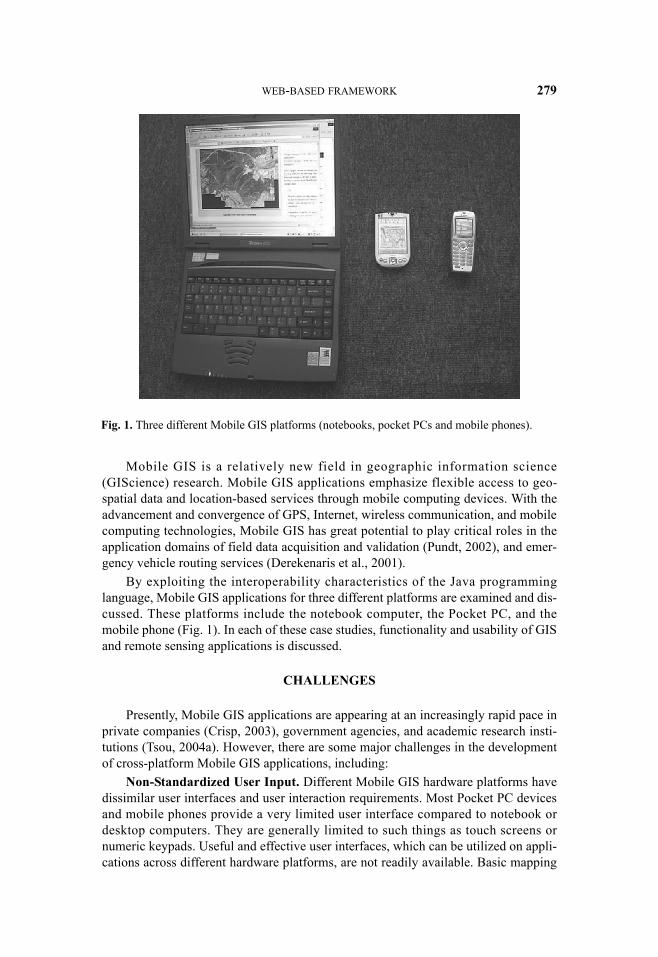
By exploiting the interoperability characteristics of the Java programminglanguage, Mobile GIS applications for three different platforms are examined and dis-cussed. These platforms include the notebook computer, the Pocket PC, and themobile phone (Fig. 1). In each of these case studies, functionality and usability of GISand remote sensing applications is discussed.
CHALLENGES
Presently, Mobile GIS applications are appearing at an increasingly rapid pace inprivate companies (Crisp, 2003), government agencies, and academic research insti-tutions (Tsou, 2004a). However, there are some major challenges in the developmentof cross-platform Mobile GIS applications, including:
Non-Standardized User Input. Different Mobile GIS hardware platforms havedissimilar user interfaces and user interaction requirements. Most Pocket PC devicesand mobile phones provide a very limited user interface compared to notebook ordesktop computers. They are generally limited to such things as touch screens ornumeric keypads. Useful and effective user interfaces, which can be utilized on appli-cations across different hardware platforms, are not readily available. Basic mapping
Fig. 1. Three different Mobile GIS platforms (notebooks, pocket PCs and mobile phones).

280 TSOU ET AL.
functions with GIS/RS datasets, such as zoom-in, zoom-out, and pan, will require dif-ferent controls for each hardware platform. A possible solution to this issue includesdevelopment of the user interface utilizing the rich cross-platform user interface toolsprovided in the Java application development framework.
CPU Speed/Power, Memory and Data Storage Capacity. Mobile GIS devicesgenerally have less computing speed/power compared to their Desktop GIS counter-parts. Desktop PCs usually have a significantly faster processor that can take advan-tage of the greater space (large computer case), more power (large power supplyconstantly plugged into an outlet), and more powerful cooling (high-wattage fans)available to them. These factors allow for a significantly more powerful, faster, andcorrespondingly hotter computer. On the other hand, Central Processing Units (CPUs)in Mobile GIS devices, which are optimized for portability, may have very littlespace, may run on very low power, and may have been designed to not run as hotcompared to their Desktop GIS hardware counterparts. Currently most Pocket PCsare equipped with a 500 MHz–600 MHz CPU. This is in contrast to Desktop PCs witha 1.5 GHz–3 GHz CPU. Memory and storage is another major limitation of MobileGIS devices. Most handheld computing devices have very limited memory and stor-age capacity with up to 4 gigabytes of nonvolatile flash memory. On the other hand,traditional Desktop GIS workstations can have upwards of 200–300 gigabytes of harddisk space. Memory and storage requirements can be significant for large GIS and RSdatasets.
Screen Size, Resolution, and Colors. Mobile computing devices generally havesmaller screen areas, more limited screen resolution (pixels per unit area), and morelimited color depth (number of displayable colors) for GIS/RS data display. The lackof a large screen area can significantly impact the usability of GIS/RS data displayapplications.
Dissimilar Operating Systems. There are several mainstream operating systemsfor mobile computing devices. Some include Windows Pocket PC, PalmOS,Symbian, and the Java Phon e Operating System. Adapting customized software forvarious platforms can be ve ry costly and time consuming. Mobile GIS softwaredesigned for the PalmOS mobile computing operating system will not work on aPocket PC device unless it was developed using an interoperable programmingframework such as Java. Currently, most Mobile GIS software packages are platform/operating-system specific.
Table 1 highlights some major differences between the three platforms discussedfor Mobile GIS applications. Factors included are user interface, CPU, memory,screen characteristics, and mobile computing platform operating systems.
In the context of mainstream GIS applications, most mobile devices are severelyrestricted and/or inadequate due to their small screen area, limited memory, and lim-ited computational power. Software application programmers have to overcome theselimitations in order to provide a functioning and easy-to-use user interface. In Table 1,some of the limitations might be solved advances in computer engineering technol-ogy, such as CPU, battery life, and memory storage. For example, the CPU speed ofPocket PCs has been significantly improved, from 70 MHz in 1999 (Compaq Aero1530) to 624 MHz in 2005 (HP IPAQ hx4700). Some limitations are inevitable, suchas screen size and user interface/input.

WEB-BASED FRAMEWORK 281
One possible solution to address these limitations is to develop mobile comput-ing device applications for the Java Runtime Environment (JRE). What makes Javaan effective candidate for facilitating interoperability between the varying platformslies at the heart of the Java programming language.
Unlike most computer programming languages where raw programming code iscompiled for a specific CPU and operating system, the Java programming language iscompiled for a generic CPU and operating system. This makes the code more porta-ble. When raw Java programming code is compiled, a Java compiler creates standard-ized Java “bytecode.” This bytecode represents a highly optimized set of instructionsfor a Java Virtual Machine (JVM) (Schildt, 2004). The JVM, a key component of aJRE, is actually software that simulates a generic CPU and operating system, and itinterprets Java bytecode in a uniform way (Hamilton, 1996). JVMs are available formost computing platforms and operating systems and they are packaged within aJRE. As long as the varying computer platforms have the same version of the JREinstalled, they will read, interpret, and execute the Java bytecode in the exact samemanner regardless of the operating system, computer hardware platform, etc. Becauseof the portability of Java bytecode and the availability of Java Runtime Environments(with corresponding JVMs) for all three platform study cases, it was deemed to be anappropriate software programming framework to develop interoperable GIS/RSapplications for different hardware platforms.
Table 1. A Comparison between Three Different Mobile GIS Platformsa
Typical Mobile GIS platforms: Notebook PCs Pocket PCs, PDAs,
hybrid smart phonesb Mobile phones
User interactivity/user interfaces
Regular keyboard, mouse, or pointing devices
Touch screen with stylus pen, limited function buttons
Keypads with limited function buttons
CPU 2.0 GHz (2000 MHz) (Intel Pentium M 760)
600 MHz CPU 200 MHz (some models have multiple CPUs)
Memory and data storage
512 MB RAM and 60 GB hard drive
CF-card with 1–2 GB RAM
5–30 MB RAM
Screen size and resolution
14- or 15-inch screen, 1024 × 768 or 1280 × 800 pixels
3.2- to 4.0-inch screen, 320 × 480 or 640 × 480 pixels
2-inch screen, 176 × 220 pixels
Color depth/display True color (24 or 32 bits) = 16+ million distinct colors
VGA color (16 bit), 65,536 colors
(16 bit) 65,536 colors or B/W display
Operating system Windows or MacOS Pocket PC, Smart Phone OS, or PalmOS
Phone hardware vendor–based, proprietary systems
Battery life 2–5 hours 5–8 hours 5 hours (includes talk time)
aBased on 2005 hardware specifications.bPDA/mobile phone combo.
282 TSOU ET AL.
THE DEVELOPMENT OF MOBILE GIS AND JAVA PROGRAMMING
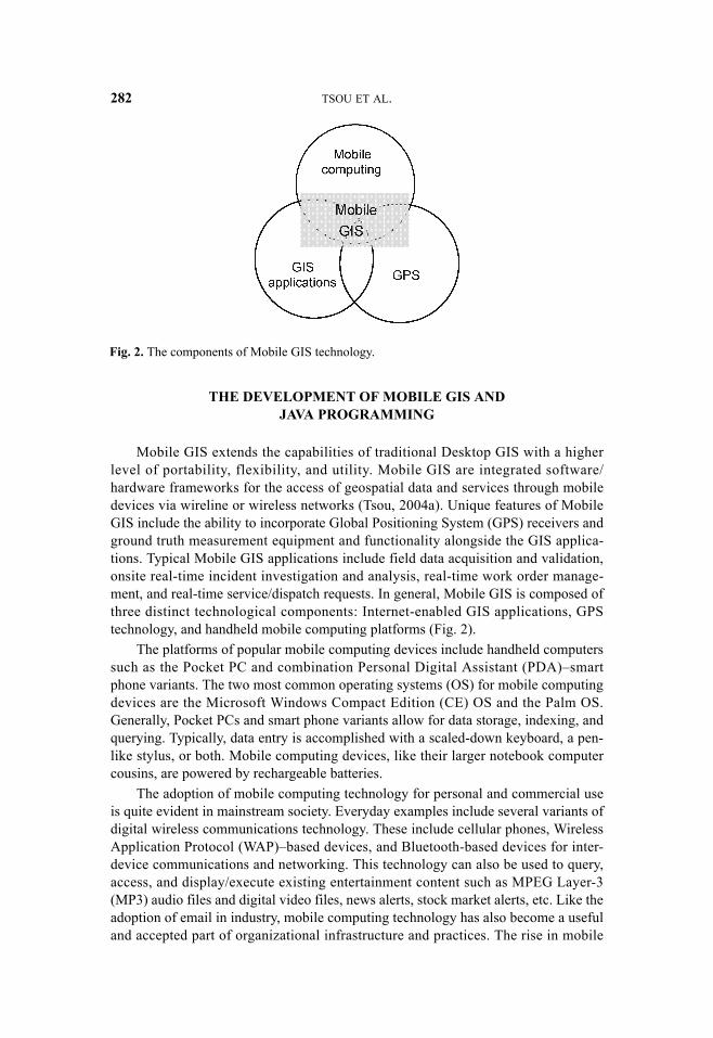
Mobile GIS extends the capabilities of traditional Desktop GIS with a higherlevel of portability, flexibility, and utility. Mobile GIS are integrated software/hardware frameworks for the access of geospatial data and services through mobiledevices via wireline or wireless networks (Tsou, 2004a). Unique features of MobileGIS include the ability to incorporate Global Positioning System (GPS) receivers andground truth measurement equipment and functionality alongside the GIS applica-tions. Typical Mobile GIS applications include field data acquisition and validation,onsite real-time incident investigation and analysis, real-time work order manage-ment, and real-time service/dispatch requests. In general, Mobile GIS is composed ofthree distinct technological components: Internet-enabled GIS applications, GPStechnology, and handheld mobile computing platforms (Fig. 2).
The platforms of popular mobile computing devices include handheld computerssuch as the Pocket PC and combination Personal Digital Assistant (PDA)–smartphone variants. The two most common operating systems (OS) for mobile computingdevices are the Microsoft Windows Compact Edition (CE) OS and the Palm OS.Generally, Pocket PCs and smart phone variants allow for data storage, indexing, andquerying. Typically, data entry is accomplished with a scaled-down keyboard, a pen-like stylus, or both. Mobile computing devices, like their larger notebook computercousins, are powered by rechargeable batteries.
The adoption of mobile computing technology for personal and commercial useis quite evident in mainstream society. Everyday examples include several variants ofdigital wireless communications technology. These include cellular phones, WirelessApplication Protocol (WAP)–based devices, and Bluetooth-based devices for inter-device communications and networking. This technology can also be used to query,access, and display/execute existing entertainment content such as MPEG Layer-3(MP3) audio files and digital video files, news alerts, stock market alerts, etc. Like theadoption of email in industry, mobile computing technology has also become a usefuland accepted part of organizational infrastructure and practices. The rise in mobile
Fig. 2. The components of Mobile GIS technology.

WEB-BASED FRAMEWORK 283
computing technology utilization is highlighted by estimates showing a 1.3 billionusers and a $20 billion market by 2005 (Intergraph, 2002).
Mobile GIS is an integrated software/hardware framework for the access ofgeospatial data and services through mobile devices via wireline or wireless networks(Tsou, 2004a). There are two major application areas of Mobile GIS: field-based GISand location-based services (LBS). Field-based GIS focuses on GIS data collection.Specific applications generally include field data validation and updating. These tasksmay involve adding or editing map features or attribute tables on an existing GISdataset. LBS generally focus on business-oriented location-management functionsincluding location search, navigation, and routing, vehicle tracking, etc. (Jagoe, 2002;OGC, 2003a). A major difference between the field-based GIS and LBS applicationareas involves data editing. Most field-based GIS applications require editing of theoriginal GIS dataset. This includes feature attribute modification. A specific examplemay entail the survey of out-of-order stoplights by a local government employee.LBS, on the other hand, rarely involve changes to an original GIS dataset. Instead, theoriginal data are used as persistent reference data, features, or “background” maplayers for query, navigation, or tracking applications.
Because Mobile GIS applications generally require cross-platform functionality,the Java programming framework has been identified as a feasible and effective toolfor Mobile GIS software development. One of the original goals of Java was to pro-vide a software application development solution for a heterogeneous and network-based distributed environment of varying systems (Gosling and McGilton, 1996).Because of Java’s powerful cross-platform capabilities, many software developersand organizations launched initiatives to explore the utility of using Java for onlineand distributed applications (Halfhill, 1997).
Distributed Java applications are generally implemented in two kinds of execu-tion environments: a compile-time environment and a runtime environment (Schildt,2004). The server-side compile-time environment generally entails the use of SunMicrosystem’s Java Development Kit (JDK). The critical components of the JDKinclude a Java compiler (Javac.exe), a Java interpreter (Java.exe), and several stan-dardized Java class libraries. Application programmers use the Java compiler to auto-matically link relevant Java class libraries and compile their text-based Java sourcecode into a Java class file represented in Java bytecode format. This Java bytecodefile can then be executed and interpreted on any local or networked computing systemwith a compatible Java Runtime Environment. The Java Virtual Machine, a key com-ponent of the runtime environment, actually interprets the bytecode file, links andloads any additional requisite compiled classes, and, in the ideal situation, producesthe exact same actions, results, output, etc. on any system. This works because theJava Virtual Machine of the Java Runtime Environment, on the client-side system,takes the intermediate Java bytecode as input and produces machine code for that spe-cific platform/system/device at runtime. This facilitates programming portabilitybecause the same Java bytecode file can be used as input to any system. Backers ofthe Java programming language describe this critical feature with the phrase, “WriteOnce, Run Anywhere (WORA)” (Douglas, 1996; WORA, 2005). The main caveat isthe requirement of a compatible Java Runtime Environment, and associated JavaVirtual Machine, on the client-side system. An out-of-date version of the runtime maynot contain the proper libraries, syntax, or functionality that is called for in the

284 TSOU ET AL.
original programming code by the application developer. Thus, it is critical that theapplication developer and the end user ensure that the client-side system has an up-to-date runtime environment. To facilitate this, Sun Microsystems and many other soft-ware vendors include automatic runtime environment detection and update function-ality when executing Java applications over networks and on client-side systems suchas Internet Web browsers.
Java also supports execution over a network such as the Internet. The server-sidebytecode class file may reside on a Web server and the client-side runtime systemmay be a Web browser with a Java Virtual Machine, or a mobile or desktop comput-ing device with a Java Runtime Environment. This powerful feature of the Java appli-cation framework is called Remote Method Invocation (RMI) and further facilitatessoftware application portability. In this instance, a constant Internet connection and acompatible Java runtime is all that is required to run an application. Backers of theJava programming language describe this feature with the expression, “The networkis the computer” (Sun Microsystems, 1998).
In general, there are two different architectures for the deployment of Java-basedGIS applications: the two-tier architecture and the three-tier architecture. Both ofthese architectures can be distinguished by the way the client-server components arepartitioned. An application can be divided into three functional components: presenta-tion, logic, and data (Shan and Earle, 1998). Figure 3 depicts the two-tier and thethree-tier architectures.
The two-tier design allocates the presentation component to the client and thedata component to the server (Peng and Tsou, 2003). The logic component is allo-cated between the clients and servers, although most of the application portion of thelogic component is on the client environments (Sadoski, 2000). Thus, the first tiergenerally consists of the presentation and logic components and the second tier con-sists of the data and some logic components. Typical examples of two-tier architec-tures include client-side Java applications, or Java applets, running on Internet Webbrowsers (Fig. 4, left).
Fig. 3. Client-server system partition.

WEB-BASED FRAMEWORK 285
Fig.
4. C
lient
-sid
e ap
plic
atio
n (le
ft) a
nd se
rver
-sid
e ap
plic
atio
n (r
ight
).

286 TSOU ET AL.
In these examples, Internet users can transparently download applications andaccess data remotely with a Java applet. Specific applications of Java applets includeonline GIS analytical tools providing advanced user interfaces, unlimited user inter-action, and high-quality image rendering techniques (Andrienko et. al, 1999;Coddington et al., 1999). The applet can run within a Web browser or through a spe-cial applet viewer that is included with Java Runtime Environments. With either inter-face, the presentation tasks and simple data processing occur on the client side—thatis, on the user’s platform/system/device. On a Web browser, it is embedded andenabled with special HTML-like applet tags. Since direct or indirect communicationis established with the server and data, applets allow most of the data processing totake place on the client computer. This can potentially reduce the processing load onthe server and support a higher degree of availability to other users (Limp, 2001).Unfortunately, the applet implementation of a two-tier architecture has some draw-backs. If the size of an applet and/or its dataset is too large, computational processingwill be slow and may tax the client computing device. The downloading time andfunctional performance can also be major concerns. These issues may effectively turnthe client-side system into an overtaxed fat client, and even paralyze the clientmachine (Huang and Worboys, 2001). Moreover, the security of the data and filesmanipulated by the applet on the client may be an issue. This is a consideration forsensitive GIS and RS datasets and applications.
In a three-tier architecture, the presentation component (the first tier) is alsohandled on the client side, the logic component (the second tier) resides on the serverside, and the data component (the third tier) resides on a stand-alone data server (Pengand Tsou, 2003). Examples of three-tier architecture systems typically include Webapplications using server-side Java applications, or Java servlets (Fig. 4, right). Muchof the functionality of these server-side components involves marshaling data,requests, and responses. Like the Java applet extending the capabilities of a Webbrowser (or a stand-alone applet viewer) on the client side, the servlet extends thefunctionality of the server on the server side (Huang and Worboys, 2001). Applets“listen” for and respond to client-side messages or requests; and proceed to gather andprocess data and execute instructions at the server side according to their programs.This middle-ware tier is used to process user requests, produce maps, and manageserver tasks (Tsou et al., 2002). With it, complex data processing and data security cantake place away from the client. After execution, the results, or other output, are gen-erated and transferred to the client (Tsou and Buttenfield, 2002). Unlike in a two-tierarchitecture, nearly all of the computation and data processing is performed on theserver side in a three-tier architecture. Because of the lack of any significant process-ing and execution at the client side, the client is usually referred to as a “thin client.”A thin client only manages the presentation component of the three-tier architecture.This generally entails a networked computing device providing a user interface and ameans to receive and/or display server-generated output.
Three-tier architectures can be more flexible than two-tier architectures. Three-tier architectures can provide flexible access to an ever-expanding number of datasets,databases, datastores, or Internet map servers available based on user requirements(Fig. 4). Unfortunately, three-tier architectures can suffer from too many clientrequests for services. This can lead to slow data transfer between clients and servers,and unacceptably slow interface display and interactivity. In the context of Mobile
WEB-BASED FRAMEWORK 287
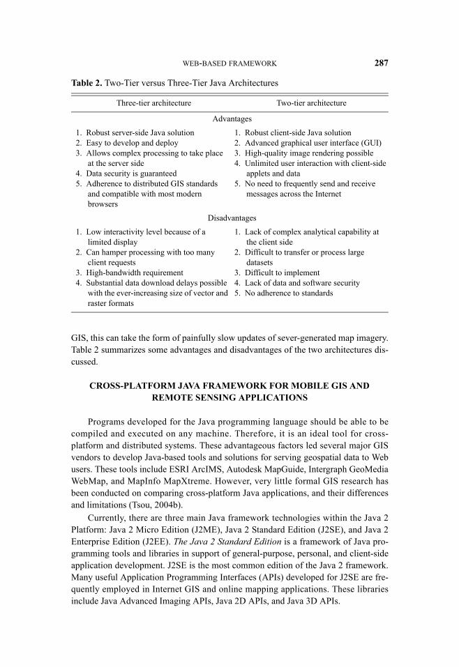
GIS, this can take the form of painfully slow updates of sever-generated map imagery.Table 2 summarizes some advantages and disadvantages of the two architectures dis-cussed.
CROSS-PLATFORM JAVA FRAMEWORK FOR MOBILE GIS AND REMOTE SENSING APPLICATIONS
Programs developed for the Java programming language should be able to becompiled and executed on any machine. Therefore, it is an ideal tool for cross-platform and distributed systems. These advantageous factors led several major GISvendors to develop Java-based tools and solutions for serving geospatial data to Webusers. These tools include ESRI ArcIMS, Autodesk MapGuide, Intergraph GeoMediaWebMap, and MapInfo MapXtreme. However, very little formal GIS research hasbeen conducted on comparing cross-platform Java applications, and their differencesand limitations (Tsou, 2004b).
Currently, there are three main Java framework technologies within the Java 2Platform: Java 2 Micro Edition (J2ME), Java 2 Standard Edition (J2SE), and Java 2Enterprise Edition (J2EE). The Java 2 Standard Edition is a framework of Java pro-gramming tools and libraries in support of general-purpose, personal, and client-sideapplication development. J2SE is the most common edition of the Java 2 framework.Many useful Application Programming Interfaces (APIs) developed for J2SE are fre-quently employed in Internet GIS and online mapping applications. These librariesinclude Java Advanced Imaging APIs, Java 2D APIs, and Java 3D APIs.
Table 2. Two-Tier versus Three-Tier Java Architectures
Three-tier architecture Two-tier architecture
Advantages
1. Robust server-side Java solution2. Easy to develop and deploy3. Allows complex processing to take place
at the server side4. Data security is guaranteed5. Adherence to distributed GIS standards
and compatible with most modern browsers
1. Robust client-side Java solution2. Advanced graphical user interface (GUI)3. High-quality image rendering possible4. Unlimited user interaction with client-side
applets and data5. No need to frequently send and receive
messages across the Internet
Disadvantages
1. Low interactivity level because of a limited display
2. Can hamper processing with too many client requests
3. High-bandwidth requirement4. Substantial data download delays possible
with the ever-increasing size of vector and raster formats
1. Lack of complex analytical capability at the client side
2. Difficult to transfer or process large datasets
3. Difficult to implement4. Lack of data and software security5. No adherence to standards

288 TSOU ET AL.
The Java 2 Enterprise Edition is a Java framework that provides applicationdevelopment tools and libraries to support server-side, institutional, and IT-basedapplication development. Software programmers can use J2EE Enterprise JavaBeanclass libraries to create re-usable distributed components for different Web Servicesand Business-to-Business (B2B) applications. Several key technologies of the Enter-prise Edition include the integration of Java and Extensible Markup Language(XML), Java Servlets technology, and Enterprise JavaBeans.
The Java 2 Micro Edition is a Java framework that provides application develop-ment tools for small computing devices including cellular phones, pagers, smartcards, and Personal Digital Assistants (PDAs)/handheld computers. An example ofthis technology includes Java Card technology, which enables very small footprintJava programs to execute on smartcard and other handheld devices with very limitedRandom Access Memory (RAM). J2ME also supports small device “profiles.” Theseare stated minimum collections of Java API libraries for each particular device orapplication. These specifications minimize program and runtime size while providingenough tools and libraries for embedded application development. An exampleJava profile includes the Mobile Information Device Profile (MIDP) which specifiesa standard set of APIs for wireless communications and mobile devices (SunMicrosystems, 2000).
The performance of similar GIS and remote sensing applications on three MobileGIS platforms using Java cross-platform development tools is examined. The first testcase involves a execution of Java applets on a notebook PC platform running theWindows XP Operating System (OS) through a modern Java-enabled Web browser.The second test case entails a Pocket PC running the Windows CE OS and a third-party Java Virtual Machine (JVM) plug-in called “CrEme,” developed by NSIcomLtd (http://www.nsicom.com). The JVM on the Pocket PC enables Java applicationexecution on Windows CE-based computing devices. Other JVM plug-ins are avail-able for Pocket PCs, Palm OS–based devices, and other mobile computing devices.CrEme was specified for the Mobile GIS application because it is able to provide afull range of Java capabilities including Remote Method Invocation (RMI) for client-server application development; Java Native Methods (JNI) for embedding program-ming code in other languages within Java; and the Swing 1.1 library for advancedGUI development. The CrEme JVM plug-in was also noted for being very stable androbust. The third test case involves the development of a Java map viewer for themobile phone platform utilizing the J2ME Wireless Toolkit. J2ME Wireless Toolkit isa set of software tools and libraries for developing wireless Java applications that arebased on J2ME’s Connected Limited Device Configuration (CLDC) and MobileInformation Device Profile (MIDP). These are a set of standards that support thesmall and limited computing environments of small wireless technology such asmobile phones. The applications developed using the toolkit include distributed appli-cations that can be executed on mobile phones and PDAs.
There are similarities and differences between the Java programming frame-works and their corresponding API libraries for the three different platformsaddressed. An example of the similarities includes the Java Swing API library foradvanced GUI development. J2ME (used in the Pocket PC and mobile phone testcases) and J2SE (used in the notebook PC test case) utilize the same set of JavaSwing APIs for GUI development. Since the CPU on a mobile phone or Pocket PC is
WEB-BASED FRAMEWORK 289
significantly less powerful than a CPU on a notebook PC, the same API libraries usedin identical applications for both platforms will appear to execute more slowly on thePocket PC or mobile phone. Further considerations of the Java J2SE and J2ME appli-cation development frameworks, as it applies to Mobile GIS application develop-ment, include the following.
1. Most Pocket PCs have restricted processing power. The CPU power of a typi-cal Pocket PC is about 200 MHz, as opposed to a notebook PC with a more powerful2GHz CPU. To overcome this shortfall, it is necessary to choose to implement onlythe most lightweight and efficient API libraries that best support the required applica-tion features. This software engineering task should be done before the developmentprocess begins to ensure smaller application footprints and better performance. In thecontext of the development of GIS or remote sensing data viewers, best practicesinclude utilization of wireless client-server technologies and using Web services toimplement complex GIS/RS procedures/functions. A solution developed for thePocket PC or mobile phone platforms should only entail simple map display function-ality on the client side. Finally, consideration should be given to certain aspects of theclient application program design. Java Garbage Collection (GC) is a runtime featurethat can be programmatically or automatically called to de-allocate references tounused physical memory in the computing device. GC frees up memory for applica-tion use. Unfortunately, this process can be taxing on a mobile computing system withminimal CPU resources. Frequent and unnecessary GC calls are computationallyexpensive, and may render an application unacceptably slow and inefficient for prac-tical use.
2. There are many other significant memory constraints on Pocket PC andmobile phone platforms. Mobile computing devices have very limited storage andruntime memory. This constrains the developer to a small runtime environment andapplication footprint. Even after choosing lightweight libraries, the developers shouldcarefully select the packaging solutions for application deployment. Part of thisentails only including Java libraries and files that are actually implemented in theapplication. Additional considerations should also be made for the partitioning of theapplications across the architecture of the whole system. By diligently allocatingcomponents of the application solution between servers and clients, additional mem-ory savings can occur while preserving the functionality of the software.
3. The user display sizes vary greatly between the mobile phone, Pocket PC, andnotebook PC platforms (Fig. 1). One of the most challenging aspects of creatingcross-platform Mobile GIS solutions is addressing the user interface and data display.Screen real estate on the smaller platforms, as well as duplicating user interface func-tionality across all three platforms, are significant considerations. Traditional, large,and graphic-intensive GUIs are not possible or practical with the smaller mobile com-puting platforms. Creation of user-friendly interfaces for Pocket PC and mobile phoneapplication solutions require implementation of such space-saving GUI features/toolsas menus, list boxes, combo box dialogs, and screen tabs. The user interface for databrowsers and simple map functions need to be carefully considered in applicationdevelopment for GIS/RS applications for mobile computing devices.
In summary, user interface simplification is one of the most important designconsiderations when developing Mobile GIS solutions on smaller computing devicessuch as the Pocket PC and mobile phones. With careful selection of lightweight API
290 TSOU ET AL.
libraries and a simplified GUI design, Java programming technology can be an effec-tive tool to build robust and user-friendly GIS application tools for basic GIS/RS datadisplay and analysis functions on mobile computing devices. The following sectionsdescribe three different Java implementations of Mobile GIS application solutions forGIS/RS functionality. These prototype solutions have been tested for environmentalmonitoring and natural resource management applications to demonstrate their poten-tial capabilities.
CASE STUDY 1: J2SE APPLICATIONS ON NOTEBOOK PCS
The first study case entails the development of a Java Web-based imagery analy-sis application for a notebook PC using the Java 2 Standard Edition (J2SE) applica-tion framework. J2SE is the most popular framework for Java development of Web-based GIS and RS applications. The J2SE Java Development Toolkit (JDK) providesrobust and well-defined APIs for geospatial data and digital image processing appli-cations. Certain relevant API libraries include the Abstract Windows Toolkit (AWT),the Java 2D, and the Java Advanced Imaging (JAI) libraries. These API libraries pro-vide flexible tools for integrating powerful image manipulation and GIS functionalitywithin a software application solution (Sun Microsystems, 1999). The notebook PCapplication prototype adopted the newest Java 2D and JAI API libraries to includesupport and functionality for complex image processing tasks including image warp-ing, image compositing, and image transparency. The Java 2D API library addresses awide range of graphical, image, and text manipulation applications. The JAI APIlibrary focuses on fundamental digital image processing functionality (Rodrigues,2001).
The JAI API library was used to develop image manipulation functions includingsemantic zooming, smooth panning, geo-linking viewers, contrast/brightness adjust-ment, minimum-maximum stretching, feature edge detection, and toggling of individ-ual RGB bands. Custom change detection functionality was also developed formonitoring, detecting, and interpreting changes to natural wildlife habitats over timeusing RS imagery. Functionality for user-digitized polygons was also developed forthe identification and analysis of changes at specific land areas. This feature enablesthe end user to identify critical areas of change, such as newly burned areas. Changedetection is also possible with these tools because they make it possible to comparethe shapes and sizes of digitized polygons for different temporal periods.
The test bed implementation was focused on identifying change under rapidlychanging habitat conditions including non-native plant invasion, fire and post-firesuccession, and recreation and transportation-related impacts to the physical land-scape (Stow et al., 2001). All of these functions were accessible using a standard Webbrowser as an interface to a suite of image processing and GIS tools. One such tool,the Image Swipe Java Applet, is provided as an example in Figure 5.
The Image Swipe Tool was designed for Web-based GIS and RS applications. Itwas developed for flexible comparative analysis of overlaid geographically registeredmulti-temporal imagery. It enables the user to view specific portions of the layeredtop and bottom images at the same time using a vertical or horizontal swipe tool(Fig. 6). The swipe tool slider functions like a curtain and reveals different imageryseparated by a thin vertical or horizontal slider bar. A user can manipulate the swipe

WEB-BASED FRAMEWORK 291
to comparatively reveal different portions of the overlaid imagery, thereby aiding in avisual change detection analysis. In the test bed example, users were able to compareland cover changes between 2000 and 2001 using ADAR imagery (Fig. 6). Zoom andpan functionality was also available and implemented with a rectangular yellow zoombox tool.
Portions of the Java programming code used to implement the Java Image SwipeTool are presented below for illustrative purposes:
int swipeWidth; //For horizontal swipeint swipeHeight; //For vertical swipe
public float horizontalSwipe(float x) {
swipeWidth = (int)(x * getSize().width);repaint();return x;
}public float verticalSwipe(float y){
swipeHeight = getSize().height - (int)(y * getSize().height);repaint();return y;
}public void paint(Graphics g) {
g.drawImage(bottomImage,0, 0, this); //Draw the bottom image//Draw the portion of the top image with horizontal swipeg.drawImage(topImage, 0, 0, swipeWidth, imageHeight, 0, 0,swipeWidth, imageHeight, this);
Fig. 5. The Image Swipe Java applet [http://map.sdsu.edu/arc/imgswipe].

292 TSOU ET AL.
//Draw the portion of the top image with vertical swipe g.drawImage(topImage, 0, 0, imageWidth, swipeHeight, 0, 0,imageWidth, swipeHeight,this);
}
The code for the applet utilizes the horizontalSwipe and verticalSwipe methods totrack the position of the swipe line in order to support client display and user interfacefunctionality. The swipeWidth and swipeHeight variables store the size of the visualareas covered by each side of the swipe lines in order to fill the user display. The paintmethod facilitates generating and updating the client display based on user input.
In general, Java programming for notebook PC applications is relatively easy andstraightforward. The framework provides an effective tool for development of GIS/RS applications. It should also be noted that any notebook computer with an appropri-ate Java runtime, regardless of its native operating system, should be able to executethis Java Swipe Tool applet.
It should be reiterated that great consideration must be made regarding the ver-sion of the Java Runtime Environment available on the client-side mobile computingdevice. If the appropriate version of the JRE and its corresponding Java VirtualMachine is not available on the client side, the Java applet may not have the appropri-ate resources to function on the client mobile computing device. To address theseissues, hardware and OS-specific JREs or Java Runtime Web browser plug-ins can bedownloaded for free at Sun Microsystem’s Website (http://java.com/en/). Many newer
Fig. 6. The Java Imagery Change Detection Function.
WEB-BASED FRAMEWORK 293
Web browsers also have built in support for the newer versions of the Java Runtimewhen they are installed on client computing devices. Additionally, many applets andbrowsers have support for on-demand updates and installation of appropriate Javaruntime resources.
CASE STUDY 2: J2ME ON THE POCKET PC PLATFORM USING THE CrEme JVM PLUG-IN
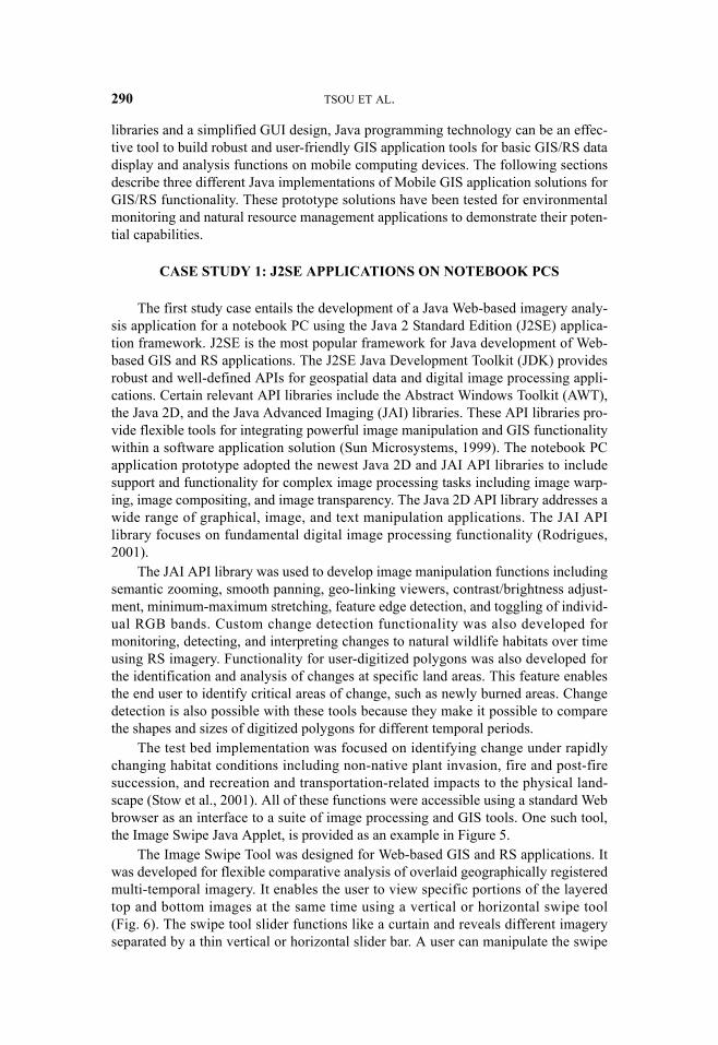
The second study considers the development of a Java Web-based imagery analy-sis application for the Pocket PC platform utilizing the Java 2 Micro Edition (J2ME)application development framework. Java development of Mobile GIS applicationtools for the Pocket PC platform and the Windows CE OS is challenging given thefact that native Java support is not available on the system. To address this issue, acompatible Windows CE OS–specific Java runtime is required. One such solutionentailed the use of the CrEme third party compact runtime application for the Win-dows CE OS of the Pocket PC platform. The CrEme application tool was selected forits robust support of many Java API libraries and functionality that are useful forMobile GIS development. The CrEme tool includes support for Remote MethodInvocation (RMI) functionality, and many advanced user interface and image displayAPI libraries. These include the JNI API, the Swing 1.1 API, the Tiny AWT API, andthe Truffle graphical toolkits API. A CrEme Web browser plug-in, which functions asan embedded JVM for the Pocket version of Microsoft Internet Explorer, is alsoincluded with the application package. With this plug-in, compatible Java applets canbe executed through the Pocket Internet Explorer Web browser. Figure 7 compara-tively illustrates an identical image analysis applet executing on Web browsers on thePocket PC and Notebook PC platforms.
Fig. 7. Crossing-platform Java Web Applet execution: pocket PC (left) and notebook PC(right).

294 TSOU ET AL.
Because of Java’s emphasis on cross-platform functionality, Java source codemodifications that are required for multiple platform/platform deployment are gener-ally minimal. Java source code originally written in the J2SE framework for the note-book PC was modified to accommodate the display, functionality, and memorylimitations of the Pocket PC platform using the J2ME framework. The resulting Javaapplet for the Pocket PC platform was packaged and deployed as a downloadableJava Archive (JAR) file.
J2ME framework–based applications can integrate newer and existing APIclasses for development of future Internet-based GIS and RS applications on thesmaller platforms. Figure 7 illustrates the differences between the same Mobile GISimage analysis application for the Pocket PC and notebook PC platforms. TypicalPocket PC devices have a significantly smaller screen display area (320 × 240 pixels)compared to standard notebook PC display screens (1024 × 768 pixels). Because ofthis, usability of the GUI can become an issue as noted in the figure. The Pocket PCversion of the applet on the left side of the figure illustrates that the user must rely onthe scrollbars to view the entire GUI display area which is readily visible on the note-book PC version of the Mobile GIS application on the right.
Figure 8 illustrates a GUI design that is better suited for user interaction and datadisplay on a Pocket PC platform compared to the previous example. This is noted bythe lack of having to use scrollbars to view the GUI and data display in the Pocket PCversion of the application. Additionally, the form and functionality of the originalnotebook PC version appears to be well preserved in its implementation on the PocketPC platform.
Other programming frameworks exist for the creation of Mobile GIS applicationson small platform computing devices. These frameworks include the Palm Conduit
Fig. 8. Crossing-platform Java Web Applet execution: pocket PC with improved GUI (left) andnotebook PC (right).

295 TSOU ET AL.
Development Kit (CDK) for Palm OS platforms and Microsoft’s .NET CompactFramework for Pocket PC platforms.
The .NET Compact Framework is a major competitor to the J2ME applicationdevelopment framework, and is designed to handle XML Web services messaging.By supporting XML messaging, the Compact Framework can be utilized to developthin client applications that can employ the many public and private Web services anddistributed computing resources currently available. On the surface, this may appearto be an ideal framework for Mobile GIS application development. However, the.NET Compact Framework (CF) is not a true cross-platform solution and is currentlylimited for development of Windows CE OS–based device applications. J2ME, on theother hand, provides a better solution for the development and deployment of GIS/RSapplications on a Mobile GIS system.
CASE STUDY 3: MOBILE PHONE APPLICATION DEVELOPMENT USING THE J2ME WIRELESS
TOOLKIT FRAMEWORK
The third case study entails a J2ME wireless GIS data viewer running on amobile phone platform. Java was utilized to enable GIS data query, display, andmanipulation on a mobile phone display. This was demonstrated with GIS data con-sisting of ESRI Shapefiles.
In order to access GIS data, the data must be stored on a remote Web server.This is because the data are often too large to store within the mobile phone. Instead,the mobile phone is used as a dynamic data viewer that can be used to query, down-load, display, and manipulate portions of the user-required GIS data. In order toenable this functionality on a memory, processor, and display-constrained computingdevice such as a mobile phone, an extremely robust and compact application develop-ment framework is required. In the case of the wireless GIS data viewer, the J2MEWireless Toolkit framework was adopted. Using this application framework, a GISMIDlet was developed for the mobile phone platform. A MIDlet is a compact Javafile which conforms to the Mobile Information Device Profile (MIDP) for extremelysmall computing devices like mobile phones (Riggs et. al, 2001). MIDlets objectsextend the Javax.microedition.MIDlet API class and contain other special APIsfor development over wireless communications and on mobile devices (SunMicrosystems, 2000).
Portions of the Java programming code used to implement the wireless GIS dataviewer application are given below for illustrative purposes:
import Javax.microedition.midlet.MIDlet;import Javax.microedition.lcdui.*;public class GIS extends MIDlet implements CommandListener {
boolean firstTime = true;Viewer view;protected void startApp() {
if(firstTime){view = new Viewer();
firstTime = false;}
display.setCurrent(view);
WEB-BASED FRAMEWORK 296
}
protected void destroyApp(boolean unconditional) {
notifyDestroyed();
}
protected void pauseApp() {
}
}
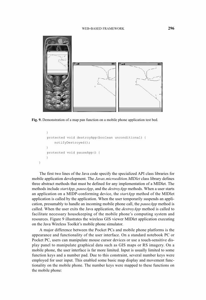
The first two lines of the Java code specify the specialized API class libraries formobile application development. The Javax.microedition.MIDlet class library definesthree abstract methods that must be defined for any implementation of a MIDlet. Themethods include startApp, pauseApp, and the destroyApp methods. When a user startsan application on a MIDP-conforming device, the startApp method of the MIDletapplication is called by the application. When the user temporarily suspends an appli-cation, presumably to handle an incoming mobile phone call, the pauseApp method iscalled. When the user exits the Java application, the destroyApp method is called tofacilitate necessary housekeeping of the mobile phone’s computing system andresources. Figure 9 illustrates the wireless GIS viewer MIDlet application executingon the Java Wireless Toolkit’s mobile phone simulator.
A major difference between the Pocket PCs and mobile phone platforms is theappearance and functionality of the user interface. On a standard notebook PC orPocket PC, users can manipulate mouse cursor devices or use a touch-sensitive dis-play panel to manipulate graphical data such as GIS maps or RS imagery. On amobile phone, the user interface is far more limited. Input is usually limited to somefunction keys and a number pad. Due to this constraint, several number keys wereemployed for user input. This enabled some basic map display and movement func-tionality on the mobile phone. The number keys were mapped to these functions onthe mobile phone:
Fig. 9. Demonstration of a map pan function on a mobile phone application test bed.

297 TSOU ET AL.
• Key 1 was mapped to the zoom-out function. (The zoom-scale was set tochange by a factor of 1.5 for each use of this function.)
• Key 0 was mapped to the zoom-in function. (The zoom-scale was set tochange by a factor of 1.5 for each use of this function.)
• Key 5 was mapped to the pan function.
• Key 2 was mapped to the move up function.
• Key 8 was mapped to the move down function.
• Key 4 was mapped to the move left function.
• Key 6 was mapped to the move right function.
• Key # was mapped to a toggle control for enabling and disabling the movefunction.
When the move function is enabled, the zoom and pan function will be disabledand a “+” symbol will appear at the center of the image display as a reference pointfor user manipulation of the feature data that are displayed on the display. When themove function is disabled, the zoom and pan functions will be re-enabled.
Figure 10 illustrates the use of the wireless GIS data viewer for on-demanddownloading of GIS data via a menu-driven user interface on the mobile phone over awireless network. This approach offers an improved solution for data viewing sincedata do not need to be stored on the client. The data can be queried and retrievedbased on user requirements. This can result in substantial savings of client memory.Additionally, this may offer the user a more flexible means to obtain data since thedata that are available for viewing may be updated, improved, or supplemented on theserver side.
There are issues and considerations to take into account associated with thewireless GIS data viewer. The packaging of GIS data elements such as point, line,and polygon features, for robust transport over a mobile phone wireless network isdifficult due to the existence of many different standards and protocols for data
Fig. 10. Demonstration of GIS data download onto a mobile phone using a menu-based userinterface.

WEB-BASED FRAMEWORK 298
organization and transfer. Next, GIS data can be very large and the transmission maybe cut short by the memory and processing constraints of the client mobile phonedevice, or by the wireless mobile phone network. Finally, end users may incur signif-icant costs associated with transferring data with their wireless communicationsplans. The additional costs may be in addition to their regular service charges.
CONCLUSION AND FUTURE WORK
Reliable geospatial information management tools with visual and analyticalcapabilities are in great demand to maximize the use of geospatial data in facilitatingdecision making processes (Gahegan, 1998; Brown, 1999). With the rapid develop-ment of wireless and mobile technology and applications, comprehensive Mobile GISapplications are requested by many GIS and RS users. With the arrival of high-bandwidth wireless mobile networks, these networks have been identified as possibledata transport mechanisms for Mobile GIS applications. Challenges still remain forthe development of robust and user-friendly Mobile GIS applications.
Heterogeneous operating systems of different mobile devices, including theWindows CE OS, the PalmOS, the Symbian OS, and the Java Phone OS, are addi-tional hurdles to development of robust cross-platform applications. A single MobileGIS application developed for several differing platforms and operating systems canbe extremely expensive and time consuming. Each individual platform and OS mayrequire a nearly complete rewrite of programming code in order to duplicate applica-tion functionality and specified requirements. To address this issue, the GIS softwareindustry and mobile computing device vendors need to establish a community-basedstandards organization for the future development of Mobile GIS applications. Pres-ently, OpenGIS Location Services (OpenLS) specifications by the Open GIS Consor-tium (OGC, 2003a) offer a good example for setting mobile application standards. Inthis instance, the organization addresses Location-Based Services (LBS) standards forMobile GIS and other applications. They have specified the adoption of XML-basedAbstract Data Types (ADT) and the GeoMobility Server for cross-platform and cross-device functionality (OGC 2003a, 2003b). Similar standards initiatives need to bepursued for field-based Mobile GIS and mobile RS applications.
Another consideration is the inadequate bandwidth of current wireless communi-cations technology. This limits the feasibility of the development of GIS and RSapplications due to their relatively large data sizes. Current wireless technology, in thebest-case scenario, can only provide up to 1 Megabit per second of data transfer viaan advanced cellular mobile phone network like CDMA or newer 3G systems. MostGIS and RS applications require high-speed network connections since GIS and RSimagery data are routinely 10–500 MB in size. Because of these considerations, andthe general lack of supporting application tools and mobile communications infra-structure, it is currently difficult to access available GIS/RS data. Pocket PCs andsimilar devices are in a more advantageous situation when it comes to bandwidth con-siderations due to their ability to use high-speed wireless protocols and devices suchas IEEE 802.11 (Wi-Fi) and Bluetooth. IEEE 802.11 technology is very robust andwell utilized, and can enable wireless data transfer at a rate of 11 megabits per secondto 54 megabits per second in the ideal situation. WiMAX is an emerging IEEE 802.16standard for broadband wireless wide-area network (WWAN) or Metropolitan area

299 TSOU ET AL.
network (MAN) applications. WiMAX can provide a larger coverage of service areathan Wi-Fi. Its communication signals can cover a range of 4–6 miles (up to 20 milesfor the long-distance setting). To address the wireless communication issue, thedevelopment of Mobile GIS applications make it possible to robustly handle erraticsignal coverage, with features such as download restart, synchronization, and contin-uation after line drops. The ideal solution is to provide seamless communicationmerged from cellular mobile coverage and the Wi-Fi/WiMAX combination.
Another challenge is the usability of Mobile GIS and remote sensing applica-tions. Most Mobile GIS devices are constrained to a platform with a limited visiblescreen area, memory, computational power, and communications ability. Muchresearch must go into human factors and GUI design. Different platforms may requireGUI modifications to best serve its target user needs. Some solutions can includeutilization of specialized input systems, including the touch-sensitive display panelson Pocket PCs and Tablet PCs, or voice-recognition technology on Pocket PC andmobile phone devices. Recent innovations in consumer-grade GPS automobile navi-gation systems may offer hints to solutions for addressing these issues in Mobile GISapplications.
Potential applications of Java framework–based programs for the display andmanipulation of GIS and RS data were examined. Visual and analytical functions ofapplications developed for three different hardware platforms were analyzed and dis-cussed. These application tools examined how users can interactively access, navi-gate, and explore visual RS and GIS data over mobile computing devices. Althoughthe development of Mobile GIS and RS applications is at its infancy, there is greatpotential for Java framework-based analytical tools in several application areasincluding environmental monitoring, natural resources management, emergency man-agement, and homeland security. Mobile GIS data collection and geospatial analysisover Internet connections can result in cost savings, the reduction of manpowerrequirements for field monitoring tasks, and encourage the sharing of analytical tools.
Other alternative approaches for Mobile GIS applications can be combined withthe Java platform. Scalable Vector Graphics (SVG) and mobile web services are twopromising future technologies for mobile GIS and remote sensing. SVG is an XML-based, two-dimensional vector graphics media format specified by the W3C in 2001(version 1.0) and in 2003 (version 1.1) (W3C, 2003). There are three types of SVGprobiles: SVG Full, SVG Basic, and SVG Tiny. SVG Full is suitable for desktop orlaptop PCs. SVG Basic (smaller than SVG Full) is designed for Pocket PC or PDAs.SVG Tiny is designed for mobile phones. The advantage of mobile SVG (Basic andTiny) compared to other graphic formats is that it can provide a compact, multimedia-enabled vector display format. SVG images are scalable and dynamic, and can beused within the Java platform. For example, SVG Tiny can become one of the majordisplay formats for J2ME applications.
Mobile web services are an extension of general web services that are built uponXML; Simple Object Access Protocol (SOAP); Universal Description, Discovery,and Integration (UDDI); and Web Services Description Language (WSDL). Mobileweb services can combine multiple functions and customizable information providedby web service providers for different mobile applications and users. The advantageof adopting web services for mobile GIS application is that web services can provideflexible combination of multiple web computing techniques with modern enterprise

WEB-BASED FRAMEWORK 300
GIS architecture. The contents of mobile web services include short messaging ser-vices (SMS), multimedia messaging services (MMS), and location-based services(LBS). Most mobile web services rely on server-side computing power significantly.For mobile GIS or LBS tasks, web services work like client-side terminals, with moreflexible choices of GIS functions provided by remote web servers rather than runningGIS functions locally. This is quite different from Java platform applications, whichutilize client-side (mobile devices) computing power for major GIS works.
To summarize, future development of Mobile GIS and RS applications shouldentail better user interface and human-factor design, and development of moreadvanced analytical tools and capabilities, including dynamic sketching, geometriccalculation, vector overlay, and image feature classification. With its features andcapabilities, the Java framework may offer a robust and appropriate cross-platformsolution to facilitate the development of the next generation of Mobile GIS and RSapplications and tools. Moreover, the cross-platform nature and accessibility of appli-cations developed within the Java framework may broaden the scope and appeal ofMobile GIS, RS, and other geospatial tools and applications for the public at large.
ACKNOWLEDGMENTS
The authors wish to acknowledge that significant portions of the content dis-cussed herein stem from the research of two projects: “A Border Security DecisionSupport System” (NASA REASoN-0118-0209) and “Integrated Mobile GIS andWireless Image Web Services for Environmental Monitoring and Management.”Additionally, the authors wish to acknowledge and express their appreciation ofmatching funds received from the National Science Foundation project, “A ScalableSkills Certification Program in GIS” (NSF-ATE DUE 0401990). Additional acknowl-edgment is extended to John Kaiser, the REASoN program coordinator, and DouglasStow, the REASoN project Principal Investigator. The authors would also like to rec-ognize Sheth Dhawal and Min Zou, graduate students at San Diego State University,for their Java programming efforts in support of the research.
REFERENCES
Andrienko, G., Andrienko, N., and J. Carter, 1999, “Thematic Mapping in the Inter-net: Exploring Census Data with Descartes,” in Proceedings of TeleGeo'99 Con-ference, Lyon, May 6-7, (1999), Laurini, R. (Ed.), 138-145.
Brown, I. M., 1999, “Developing a Virtual Reality User Interface (VRUI) forGeographic Information Retrieval on the Internet,” Transactions in GIS,3(3):207-220.
Coddington, P. D., Hawick, K. A., and H. A. James, 1999, “Web-Based Access toDistributed High-Performance Geographic Information Systems for DecisionSupport,” in Proceedings of the 32nd Hawaii International Conference onSystem Sciences, 1999.
Crisp, N., 2003, Open Location-Based Services: Technical Brief (TB1034A),Huntsville, AL: Intergraph Corporation, White paper [http://www.intelliwhere.com], accessed on December 16, 2003.

301 TSOU ET AL.
Derekenaris, G., Garofalakis, J., Makris, C., Prentzas, J., Sioutas, S., and A.Tsakalidis, 2001, Integrating GIS, GPS, and GSM Technologies for the EffectiveManagement of Ambulances,” Computer, Environment, and Urban Systems,25:267-278.
Douglas, K., 1996, The JavaTM Platform, Santa Clara, CA: Sun Microsystems, Inc.[http://Java.sun.com/docs/white/platform/Javaplatform.doc1.html], accessed onSeptember 24, 2004.
Gahegan, M., 1998, “Scatterplots and Scenes: Visualization Techniques forExploratory Spatial Analysis,” Computers, Environment, and Urban Systems,21(1):43-56.
Gosling, J. and H. McGilton, 1996, The Java Language Environment, Santa Clara,CA: Sun Microsystems, Inc. [http://Java.sun.com/docs/white/langenv], accessedon September 24, 2004.
Halfhill, T. R., 1997, “Today the Web, Tomorrow the World,” Byte, 22(1): 68-80.Hamilton, M. A., 1996, “Java and the Shift to Net-Centric Computing,” IEEE Com-
puter, 29(8):31-39.Huang, B. and M.F. Worboys, 2001, “Dynamic Modeling and Visualization on the
Internet,” Transactions in GIS, 5(2):131-139.Intergraph, 2002, Mobile Resource Management, Huntsville, AL: Intergraph Corpo-
ration, White Paper [http://imgs.intergraph.com/freebies/pdfopener.asp?item=wp&file=WP1020A.pdf], accessed on September 24, 2004.
Jagoe, A., 2002, Mobile Location Services: The Definitive Guide, Upper SaddleRiver, NJ: Prentice Hall.
Limp, F. W., 2001, “User Needs Drive Web Mapping Product Selection,” GEOworld,February 2001, 8-16.
OGC (Open GIS Consortium), 2003a, OpenGIS Location Services (OpenLS): CoreServices (Part 1-Part5). (version 0.5.0), Wayland, MA: Open GIS Consortium,Inc., OGC-03-006r1.
OGC (Open GIS Consortium), 2003b, OpenGIS Location Services (OpenLS): Part6—Navigation Services, Wayland, MA: Open GIS Consortium, Inc. (version0.5.0) OGC-03-007r1.
Peng, Z. R. and M. H. Tsou, 2003, Internet GIS: Distributed Geographic InformationServices for the Internet and Wireless Networks, New York, NY: John Wiley andSons, Inc., 710 pp.
Pundt, H., 2002, “Field Data Collection with Mobile GIS: Dependencies betweenSemantics and Data Quality,” GeoInformatica, 6(4):363-380.
Riggs, R., Taivalsaari, A., and M. VandenBrink, 2001, Programming WirelessDevices with the Java 2 Platform, Micro Edition, Boston, MA: Pearson Educa-tion.
Rodrigues, H. L., 2001. Building Imaging Applications with Java™ Technology:Using AWT Imaging, Java 2D™, and Java™ Advanced Imaging (JAI), Boston,MA: Addison-Wesley.
Sadoski, D., 2000, Two Tier Software Architectures. Software Technology Review(STR) [http://www.sei.cmu.edu/str/descriptions/twotier_body.html], accessed onSeptember 24, 2004.
Schildt, H., 2004. Java: The Complete Reference, 6/e, Emeryville, CA: McGraw-HillOsborne Media.

WEB-BASED FRAMEWORK 302
Shan, Y. P. and R. H. Earle, 1998, Enterprise Computing with Objects: From Client-Server Environments to the Internet, Boston, MA: Addison Wesley, 448 pp.
Stow, D., O’Leary, J., Coulter, L., Hope, A., and J. Franklin, 2001, Application ofDigital Imaging Technologies for Monitoring and Managing MSCP/NCCPReserves, San Diego, CA: San Diego State University, Department of Geog-raphy, Natural Community Conservation Planning Program Report.
Sun Microsystems, 1998, Java Distributed Computing Technology Further Enabledby Support from IIOP, Santa Clara, CA: Sun Microsystems, Inc. [http://www.sun.com/smi/Press/sunflash/1998-07/sunflash.980708.2.html], accessed on Septem-ber 24, 2004.
Sun Microsystems, 1999, Programming in Java Advanced Imaging, Santa Clara, CA:Sun Microsystems, Inc., White Paper [http://Java.sun.com/products/Java-media/jai/forDevelopers/jai1_0_1guide-unc/], accessed on September 24, 2004.
Sun Microsystems, 2000, J2ME Building Blocks for Mobile Device (White Paper onKVM and the CLDC), Santa Clara, CA: Sun Microsystems, Inc. [http://Java.sun.com/products/cldc/wp/KVMwp.pdf], accessed on September 24, 2004.
Tsou, M. H., 2004a, “Integrated Mobile GIS and Wireless Internet Map Servers forEnvironmental Monitoring and Management,” Cartography and GeographicInformation Science, 31(3):153-165 (the (special issue on Mobile Mapping andGeographic Information Systems).
Tsou, M. H., 2004b, “Integrating Web-based GIS and On-line Remote Sensing Facili-ties for Environmental Monitoring and Management,” Journal of GeographicalSystems, 6(2):155-174 (special issue on Web-Based GIS).
Tsou, M. H. and B. P. Buttenfield, 2002, “A Dynamic Architecture for DistributingGeographic Information Services,” Transactions in GIS, 6(4):355-381.
Tsou, M. H., Guo, L., Stow, D., and J. Kaiser, 2002, Web-Based Geospatial Infor-mation Services and Analytical Tools For Natural Habitat Conservation andManagement. Final Report For NASA Affiliated Research Center. San Diego,CA: San Diego State University, July 2002.
W3C, 2003, Scalable Vector Graphics (SVG) 1.1 Specification, Cambridge, MA:World Wide Web Consortium [http://www.w3.org/TR/SVG/], accessed onAugust 20, 2005.
WORA, 2005, “Write Once, Run Everywhere,” Wikipedia: The Free Encyclopedia[http://en.wikipedia.org/wiki/Write_once,_run_anywhere], accessed on August20, 2005.