A Water Resources Planning Tool for the Jordan River … use the Water Evaluation and Planning...
19
Water 2011, 3, 718-736; doi:10.3390/w3030718 water ISSN 2073-4441 www.mdpi.com/journal/water Article A Water Resources Planning Tool for the Jordan River Basin Holger Hoff *, Christopher Bonzi, Brian Joyce and Katja Tielbörger Stockholm Environment Institute, Kräftriket 2b, S-10691 Stockholm, Sweden; E-Mails: [email protected] (C.B.); [email protected] (B.J.); [email protected] (K.T.) * Author to whom correspondence should be addressed; E-Mail: [email protected]; Tel.:+46-8-6747070; Fax: +46-8-6747020. Received: 3 May 2011; in revised form: 8 June 2011 / Accepted: 15 June 2011 / Published: 27 June 2011 Abstract: The Jordan River basin is subject to extreme and increasing water scarcity. Management of transboundary water resources in the basin is closely intertwined with political conflicts in the region. We have jointly developed with stakeholders and experts from the riparian countries, a new dynamic consensus database and—supported by hydro-climatological model simulations and participatory scenario exercises in the GLOWA (Global Change and the Hydrological Cycle) Jordan River project—a basin-wide Water Evaluation and Planning (WEAP) tool, which will allow testing of various unilateral and multilateral adaptation options under climate and socio-economic change. We present its validation and initial (climate and socio-economic) scenario analyses with this budget and allocation tool, and invite further adaptation and application of the tool for specific Integrated Water Resources Management (IWRM) problems. Keywords: Jordan River; climate change; water database; scenario development; water management 1. Introduction In many basins around the world increasing water demand is leading to the overexploitation of limited water resources and more frequent and more pronounced periods of extreme water scarcity [1]. Despite broad acceptance of the principles of Integrated Water Resources Management (IWRM OPEN ACCESS
Transcript of A Water Resources Planning Tool for the Jordan River … use the Water Evaluation and Planning...
Water 2011, 3, 718-736; doi:10.3390/w3030718
waterISSN 2073-4441
www.mdpi.com/journal/water
Article
A Water Resources Planning Tool for the Jordan River Basin
Holger Hoff *, Christopher Bonzi, Brian Joyce and Katja Tielbörger
Stockholm Environment Institute, Kräftriket 2b, S-10691 Stockholm, Sweden;
E-Mails: [email protected] (C.B.); [email protected] (B.J.);
[email protected] (K.T.)
* Author to whom correspondence should be addressed; E-Mail: [email protected];
Tel.:+46-8-6747070; Fax: +46-8-6747020.
Received: 3 May 2011; in revised form: 8 June 2011 / Accepted: 15 June 2011 /
Published: 27 June 2011
Abstract: The Jordan River basin is subject to extreme and increasing water scarcity.
Management of transboundary water resources in the basin is closely intertwined with
political conflicts in the region. We have jointly developed with stakeholders and experts
from the riparian countries, a new dynamic consensus database and—supported by
hydro-climatological model simulations and participatory scenario exercises in the GLOWA
(Global Change and the Hydrological Cycle) Jordan River project—a basin-wide Water
Evaluation and Planning (WEAP) tool, which will allow testing of various unilateral and
multilateral adaptation options under climate and socio-economic change. We present its
validation and initial (climate and socio-economic) scenario analyses with this budget and
allocation tool, and invite further adaptation and application of the tool for specific
Integrated Water Resources Management (IWRM) problems.
Keywords: Jordan River; climate change; water database; scenario development;
water management
1. Introduction
In many basins around the world increasing water demand is leading to the overexploitation of
limited water resources and more frequent and more pronounced periods of extreme water scarcity [1].
Despite broad acceptance of the principles of Integrated Water Resources Management (IWRM
OPEN ACCESS
Water 2011, 3
719
see [2]), which calls for a multifaceted approach to resolving water management issues, responses
often still focus narrowly on supply side management, or the ―hydraulic mission‖ [3], which includes
large-scale infrastructure projects, such as dams, reservoirs and water transfers. The Jordan River basin
has been no exception to this. Water resources management in the Jordan River Basin is further
complicated by the transboundary nature of most surface and ground water resources as well as the
transboundary and contested allocations and uses of water resources [4].
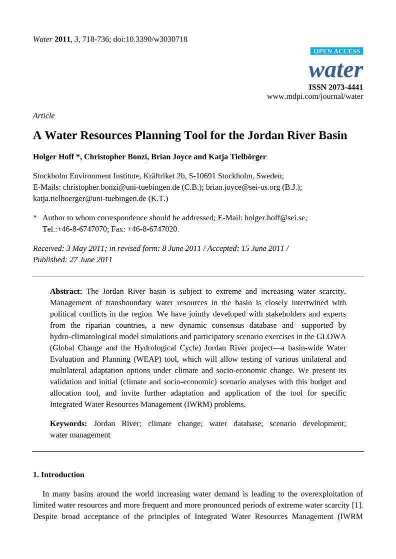
The Jordan River basin as a whole (Figure 1) is subject to extreme water scarcity. Per-capita annual
water availabilities in the three riparian countries included in this analysis exceed all typical scarcity
thresholds by far (Israel: 325 m3, Jordan 150 m
3, Palestine 70 m
3, normally the threshold is set at
1,700 or sometimes at 1,000 m3) [5]. Rainfall in the basin is highly variable in space and time. It
ranges from more than 900 mm per year in the north of Israel to less than 100 mm south of the Dead
Sea, with rainfall occurring only in the winter months. Most of the runoff is generated in the upper
catchment (north of Lake Tiberias), while the lower (southern) part of the basin has only a few
significant perennial tributaries (see Table 1). Hence, southern and eastern parts of the basin depend
more strongly on water transfers and/or groundwater (GW). Accordingly, the main aquifers are
overexploited, e.g., in Jordan by about 100% above recharge rates [6]. Despite many supply and
demand management measures already implemented, water resources are seriously overexploited in
the basin, most evident from the lack of freshwater flowing in the lower Jordan and the shrinking Dead
Sea (sea level drops by about 1 m per year causing new problems, e.g., loss of habitats, cultural
heritage, touristic value and also increased groundwater discharge from surrounding aquifers). Water
scarcity is expected to worsen in the future, as more than 80% of the global climate models are
projecting a decrease in precipitation for the region [7] and continued rapid population and economic
growth is increasing water demand.
Figure 1. Jordan River Basin, including the upper catchment north of Lake Tiberias and
the lower catchment south of the lake. The upper catchment is shared between Lebanon,
Syria and Israel, the lower catchment is shared between Syria (Yarmuk), Jordan, Palestine
and Israel. Map source: ESRI Data & Maps, 2006.
Water 2011, 3
720
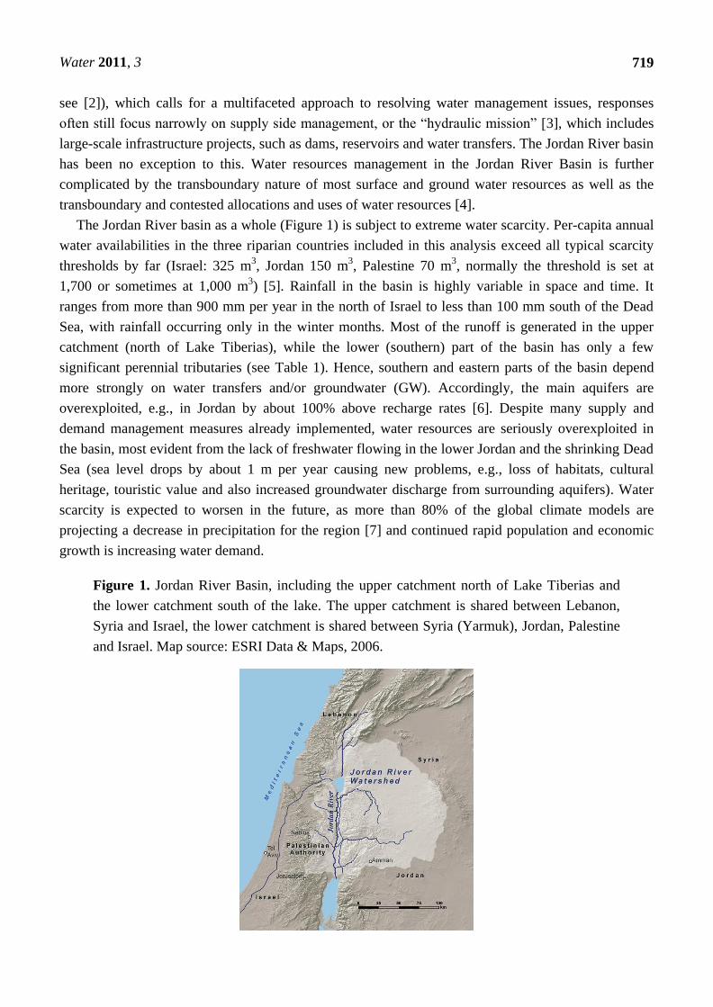
Table 1. Approximate water budget for average year (see data section further below for
period over which averaging took place and for details on the method used
(in million m3–MCM)).
Surface Water Supply Annual Streamflow (MCM)
Upper Jordan River (Hazbani, Dan, Hermon) 676
Yarmouk River 495
Zarqa River 85
Lower Jordan River–East side wadis 43
Lower Jordan River–West side wadis 40
Total Supply 1,339
Groundwater and Other Supplies Annual Net Production (MCM)
Mountain Aquifer *–Groundwater/Springs 693
Jordan–Groundwater/Springs 139
Israel–Local Groundwater/Springs 534
Israel–Flood Capture 164
Israel–Desalination 42
Total 1,572
Water Demand Annual Demand (MCM)
Jordan Municipal 100
Jordan Agricultural 103
West Bank Municipal 102
West Bank Agricultural 161
Israel Agricultural–in basin 357
Israel Municipal–in basin 10
Israel Agricultural–out of basin 766
Israel Municipal–out of basin 805
Upper Yarmouk Diversion to Syria 360
Total Demand 2,764
* Israel and West Bank Palestine both draw from the Mountain Aquifer; Note that Israel‘s
desalination capacity has now reached about 250 MCM per year, but we have used an
average value (42 MCM) for the baseline situation.
While the riparians of the Jordan River basin (Jordan, Palestine, Israel, Syria, Lebanon–here for
data availability reasons only the first three are included) have initiated a number of demand-side
measures, the key responses to the increasing water scarcity are still focused on supply-side
interventions. In recent decades, large-scale water withdrawals and transfers have reduced flows in the
lower Jordan River to about 1/10th of their historic level [8]. Now, even bigger infrastructure projects
are underway or planned, in particular a chain of desalination plants along the Mediterranean coast and
a new water transfer from the Red Sea to the Dead Sea also to provide desalinated water.
The issues of water scarcity within the Jordan River basin are so pronounced that no proposal
(structural or non-structural) is left off the table. The extent to which these efforts can work together to
resolve water shortages within the region, however, must be evaluated in the context of hydrological
and operational regimes that govern the distribution and allocation of water throughout the basin.
To date, while there have been several tools developed to consider water management within
portions of the Jordan River basin [9-13], no tool has been developed for integrated, spatially explicit
Water 2011, 3
721
and basin-wide (trans-boundary) assessments of land and water supply and demand management
options. The objective of this study is to report on the development and testing of an analytical,
quantitative and spatially explicit IWRM tool that can be used in subsequent studies to evaluate and
compare different structural and non-structural water management interventions under a range of
uncertainties associated with the evolution of future water supplies and demands. We use the Water
Evaluation and Planning (WEAP) system to develop a water resources planning tool for the Jordan
River basin. This tool provides a consistent basin-wide framework in which we have consolidated the
best available water data from the riparian countries Jordan/Palestine/Israel. The development of the
WEAP tool presented here (including the data consolidation, water system configuration, and scenario
development) has been undertaken in a continuous dialogue with local project partners and
other stakeholders.
With this tool in place, we can begin to address system-wide effects, spatial response patterns, and
tradeoffs between different unilateral or multilateral adaptation options, such as new transfer schemes,
additional non-conventional water supplies, improved demand management and loss reduction,
wastewater reuse and rainwater harvesting. This model will allow for the further testing of different
combinations of these options under a range of climate and socio-economic change scenarios, which
project future water supply and demand until the year 2050. The WEAP model serves as an integrated
database and analysis tool that can be used to evaluate the scenarios which have been generated as part
of the GLOWA Jordan River project, as well as other scenarios and strategies.
2. Methods and Data
The WEAP system has been used to consolidate water-related data and to simulate current and
future management and allocation rules for the Jordan River basin, as provided by the local project
partners. WEAP is a water resources modeling and planning tool, which in its simplest form is similar
in structure to other water allocation decision support tools: MODSIM [14], RiverWare [15],
HEC-ResSim [16], and Oasis [17]. It also provides advanced features that allow it to link dynamically
to other models and software, such as Qual2K, MODFLOW, PEST, Excel, and GAMS. The flexibility
of the tool to adapt to different levels of data availability and its user-friendly graphical user interface
make it a suitable tool to use in a basin such as the Jordan River, where data can be scarce and
stakeholder interest is high [18].
WEAP has been widely used in dozens of basins around the world [19] to support collaborative
water resources planning by providing a common analytical and data management framework to
engage stakeholders and decision-makers in an open planning process [20-23]. The tool allows for the
integration of demand and supply-based information together with hydrological simulation capabilities
to facilitate integrative analysis of a user-defined range of issues and uncertainties, including those
related to climate, changing human and ecosystem water demands, and infrastructure development.
The user-defined demand structure and water allocation priority and supply preference designations
drive the linear programming allocation algorithm for the water balance [18].
The WEAP system was selected to model the Jordan River basin because it utilizes a scenarios-based
approach that facilitates the exploration of a wide range of demand and supply options for balancing
competing operational objectives. Additionally, WEAP allows for a reduced level of complexity to
Water 2011, 3
722
represent water systems, which, in combination with the graphical user interface, facilitates the testing
of several scenario combinations independently by policy makers and other stakeholders. The
usefulness of this approach has recently been confirmed by the Jordanian Ministry of Water and
Irrigation adopting WEAP as a central tool in their Nation Water Master Plan [24]. In the MENA
region (in particular in Morocco, Tunisia, Jordan, Palestine, Lebanon, Syria), a WEAP version coupled
with the ModFlow groundwater model has been applied to address conjunctive surface and
groundwater management [23]. Within the Jordan River basin, WEAP is used to develop and assess a
variety of scenarios that explore adaptation measures, such as additional non-conventional resources or
water transfers, as well as socio-economic changes or policies affecting population growth or the
patterns of water use. A detailed description of WEAP is found in [18].
Within the Jordan River basin, the WEAP model provides a consistent transboundary framework
for addressing environmental, technical, socio-economic, institutional and political aspects of water
management that could not be addressed in national sub-basin models alone. As described below, these
aspects are integrated in WEAP as different scenarios, e.g., of technical development/water use
efficiency, as well as socio-economic development in the form of population and GDP growth and
associated growth in water demand. Institutional and political aspects have been represented in WEAP
via participatory scenario development with stakeholders from all three countries, in particular from
the main water management institutions, Jordanian Ministry of Water and Irrigation, Israel Water
Authority and Palestinian Water Authority. A separate paper is currently produced on this participatory
scenario development [25]. At the same time, WEAP represents the water system at a reduced
complexity, which facilitates participatory scenario development and analysis with water managers
and other stakeholders within the basin.
The WEAP Model of the full Jordan River Basin has been developed with increasing support from
partners in all three countries involved, based on initial national sub-basin WEAP models, e.g., for the
upper Jordan River [9], the West Bank [10], Jordan Valley [11] and the Amman-Zarqa basin [12]. The
basin-wide WEAP model presented here consistently integrates and aggregates the more detailed
databases and topologies of these sub-basin WEAP models.
Most of the data entered into the Jordan River WEAP model have been obtained from–or at least
cross-checked by–official sources, i.e., the Jordanian Ministry of Water (MWI) and Irrigation, the
Palestinian Water Authority (PWA) and Ministry of Agriculture (MoA) or the Israeli Water Authority
(IWA). Improving the underlying data structure and data quality is a continuous ongoing process. All
data are checked for inconsistencies and harmonized across countries. The resulting new consensus
database presents a major step forward, beyond the only other multi-lateral water database for the
Jordan River region from the EXACT project [26] which is static, non-spatially explicit and not
available in electronic form. The WEAP database is constantly updated with improved data when these
become available. The data entry into WEAP via (.csv) spreadsheets facilitates the update of individual
parameters. WEAP then recalculates simulation results based on the latest data.
The Jordan River WEAP model is run at monthly time steps, so all input data, irrespective of their
original temporal resolution, are aggregated (or in a few cases disaggregated) to monthly resolution.
Disaggregation, e.g., for some less well monitored wadis or groundwater aquifers, has been done by
overlaying measured annual data with monthly variations from the nearest available basin.
Water 2011, 3
723
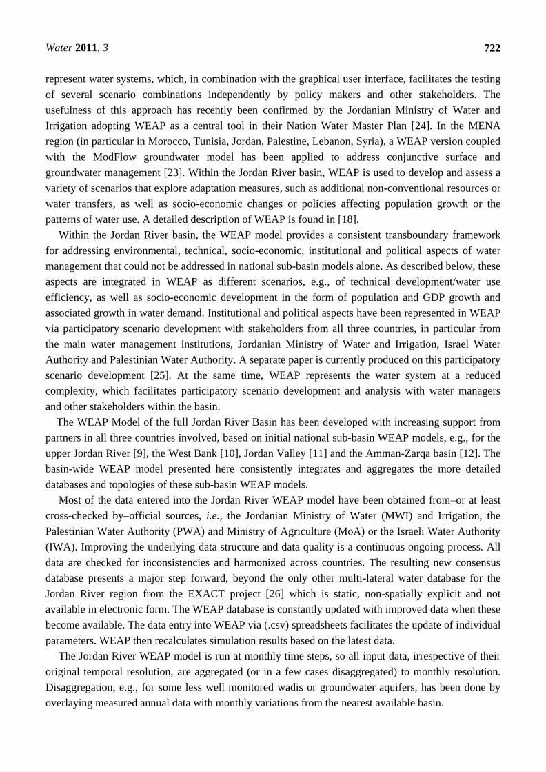
2.1. Network Topology
The geographical focus of the Jordan River WEAP model is the river basin and includes
representations of the main water management features within the watershed. This includes all of the
major tributaries, the major groundwater aquifers, the main reservoirs/water bodies (Lake
Tiberias/Kinneret, the Dead Sea, and Al Wehdah, Arab, Ziglab, Shueib, and Kafrein dams), the major
irrigation canal (King Abdullah Canal, KAC which also transfers water to the Jordanian highland); the
major trans-basin diversion (the National Water Carrier, NWC, which transfers water from the basin to
the coastal plains in Israel), and the agricultural and municipal demands that are associated with these
supply sources. Also, relevant external supplies are included in the model, such as the Disi aquifer,
which in the future will provide additional water to the basin, and a series of desalination plants along
the Mediterranean, which are expected to reduce the demand for water from the NWC.
The WEAP schematic (Figure 2) shows, how the main features of the Jordan River water system
have been aggregated and represented in WEAP as so-called supply and demand nodes, transmission
links between these nodes and water allocation rules (demand and supply priorities)–not shown.
Figure 2. Conceptual representation/model schematic of the Jordan River water system in
WEAP, with Lake Tiberias dividing the basin into an upper (upstream of the lake) and
lower (downstream of the lake) part.

Water 2011, 3
724
2.2. Water Supplies and Demands
The data compiled from the respective national sources describe the temporal and spatial
distribution of water supplies and demands for the different parts of the basin. While most of the data
is representative of historical conditions from the recent past (i.e., 10–15 years), some of the discharge
data for the larger tributaries dates back as far as 1970. These data were used to construct a baseline
scenario that represents current water management conditions.
Average annual supply and demand data for the baseline situation are summarized in Table 1.
Depending on the type of data, different historical periods were used:
- river and wadi flows use average records for the period 1970–2000, wherever the data was
available, the same period was used for groundwater.
- water demands and delivery data is based on 2000–2005, records.
- for water sources being developed (such as desalination or treated waste water) the actual
production quantities for the year being referenced were used
Whenever the full historical period could not be obtained, data was taken from shorter time series
(e.g., for some eastern side wadis data was only available for the period 1990–2005), or from nearest
data series (e.g., for some demand nodes data was only available for the time period 2002–2007).
The data suggest that on an average annual basis total demands account for approximately 95 percent
of the developed supplies. When we account for operational constraints and the timing of peak
demands, however, we find that total demands are rarely fully met. Also, we calculate agricultural
water demands from irrigated areas and associated crop water demands, not from real food demands of
the basin population (which are primarily met by importing food and that way saving the amount of
water that would be required for local production—also called imports of ―virtual water‖).
This water balance emphasizes the disparity between the relatively wet upper Jordan River
catchment with low population density and the drier lower Jordan with higher population density/water
demand—and the even higher water demands outside of the basin (which cannot be met by natural
water supplies alone—not shown here).
2.3. Surface Water Supplies
The three main tributaries (Hazbani, Dan, and Hermon) in the upper catchment provide the bulk of
the Jordan River discharge and feed Lake Tiberias (see Table 1). The next largest tributaries to the
Jordan River are the Yarmuk and the Zarqa Rivers in the lower catchment of the Jordan River
(i.e., below Lake Tiberias), with the Zarqa River mostly carrying the wastewater of the largest city in
the basin, Amman. The western and eastern side wadis of the lower Jordan together represent less than
10% of total basin discharge. The sum of discharge from all tributaries implemented in the regional
WEAP model adds up to 1339 MCM per year, which matches the literature value of 1300 MCM [8] well.
Monthly discharge data have been implemented in WEAP for all gauged tributaries to the Jordan
River, representing the respective inter- and intra-annual supply-side variability. Many of the smaller
tributaries (i.e., wadis), however, do not have sufficiently long or detailed records. Thus, the available
data was used to estimate average annual and monthly discharge for each of these wadis.

Water 2011, 3
725
2.4. Groundwater and Other Supplies
All aquifers in the Jordan River basin were aggregated to the level of detail used in the EXACT
project to describe groundwater basins. Groundwater recharge data for each basin from the EXACT
database have been supplemented and updated with newly available national data. Each groundwater
basin was connected in WEAP through transmission links to all those demand nodes that are known to
receive water from it. Groundwater sources are considered to the extent that they contribute to water
availability in the Jordan River basin. This may be through direct provision of water to basin‘s demand
nodes or provision of water to other nodes which are connected to the basin (e.g., also GW sources
providing water to Israeli demands along the coast, which are also supplied by water from Lake
Tiberias), or the provision of water to demand nodes which produce return flows to the Jordan River
catchment (e.g., water from the Azraq basin supplied to municipal demands in Amman, which return
wastewater to the Zarqa river).
2.5. Agricultural Water Demands
Agricultural water demands from national statistics were aggregated to the main irrigation districts
in the Jordan Valley (northern, middle and southern), in the upper Jordan River catchment, and to six
aggregated West Bank governorates. Other agricultural demands outside of the basin (in Israel) have
only been included to the extent that they affect water withdrawals from the Jordan River (through the
National Water Carrier) or from the Mountain Aquifer.
Each agricultural demand node represents the respective agricultural area multiplied by the average
irrigation requirement per hectare in the respective part of the basin. Areas and area-specific irrigation
requirements were implemented individually in WEAP for the main crops in each node as detailed
as available.
We only account for blue (i.e., irrigation) water use at this stage (future efforts will add green water,
i.e., rainfed agriculture). Where real agricultural water use and withdrawal data are not available (in
particular the Jordanian demands in the Jordan Valley), we use in WEAP net irrigation requirements,
calculated according to [27]. With that we underestimate the agricultural water demand, due to the
difference between gross and net irrigation requirement. We simulate in WEAP the observed seasonal
pattern of irrigation with two cropping seasons in the Jordan Valley, one in spring and one in fall, and
one cropping season with maximum irrigation water requirement in summer in the rest of the basin.
More detailed crop water use functionalities implemented in the WEAP-Mabia module (similar to the
CropWat model of the Food and Agriculture Organisation (FAO) will be used in more detailed
analyses of irrigation water demands and gaps that will be described in subsequent papers.
2.6. Municipal Water Demands
All municipal demands drawing water from the Jordan River basin are captured in WEAP as
aggregate municipal demand nodes. Each node represents the respective population multiplied by the
average per capita water demand in that area. Municipal demands in the West Bank for example are
represented by one demand node per aggregated governorate. Given the severe resource and political
restrictions in Jordan and the West Bank respectively, which constrain the municipal water use, we

Water 2011, 3
726
agreed with local project partners to apply a hypothetical per capita demand of about 50 m3 per year
which is slightly higher than the WHO recommendation of 130 L per day (or 47.5 m3 per year).
Israeli municipal demands are represented in WEAP by real per capita consumption taken from
national statistics.
In this study, we have applied WEAP in its basic form as a water budget and allocation model,
without using any of the WEAP options to simulate individual processes (such as runoff generation,
groundwater recharge, vegetation or crop water use, etc.). As such, WEAP simulation results entirely
depend on the quality of the input data (e.g., river discharge, groundwater recharge, urban and
agricultural demands, etc.) in combination with the topology of the water system (i.e., the location and
interlinkages of demand and supply nodes), and the priorities specified for water demands, supplies
and allocations.
Hence, calibration and validation of model‘s process parameters and simulations in a strict sense
(e.g., comparing simulated against measured river discharge) is not possible. However, we have
validated some of the key system components, i.e., the main aquifer (Western Mountain Aquifer), the
main reservoir (Lake Tiberias), and the main water transfer (National Water Carrier) for their water
stores and fluxes against independent measurements.
2.7. Validation for Pumping from the National Water Carrier
Water demands in the Mediterranean coastal plains of Israel are largely met from the National
Water Carrier (NWC), which transfers water from the upper Jordan River that is stored in Lake
Tiberias. Pumping of water through the NWC is driven in WEAP by all demands which are linked to
this conduit, and it is constrained by the availability of water in the Lake. Since most demand nodes
connected to the NWC are also linked to additional surface and groundwater nodes, we implemented
demand priorities, access restrictions and intra- and inter-annual variation according to the
specifications of our Israeli partners, in order to represent the system realistically. We have then
validated the NWC pumping by comparing the rates at the outlet of Lake Tiberias as simulated by
WEAP with official pumping rates provided by the Israeli Water Authorities for the years 2002 to
2007, showing good agreement (Figure 3).
Figure 3. Comparison of WEAP simulated vs. measured pumping by the NWC (in million
cubic meters–MCM per month).
Water 2011, 3
727
2.8. Validation for Lake Tiberias Storage
WEAP integrates all river discharges and consumptive water uses of the upper Jordan River
catchment as inflows into Lake Tiberias (see Figure 2). We used all available discharge measurements
and demand data from the upper catchment including also the pumping from the Lake by the NWC.
Missing demand data were filled with aggregated demands from the sub-basin WEAP model by [10].
We then compared the resulting lake storage changes over time, simulated by WEAP with measured
values [28,29]. WEAP simulations match the measured values which were obtained for the years
2000 to 2005 well (Figure 4).
Figure 4. Comparison of WEAP simulated vs. measured lake volume in million cubic
meters (MCM).
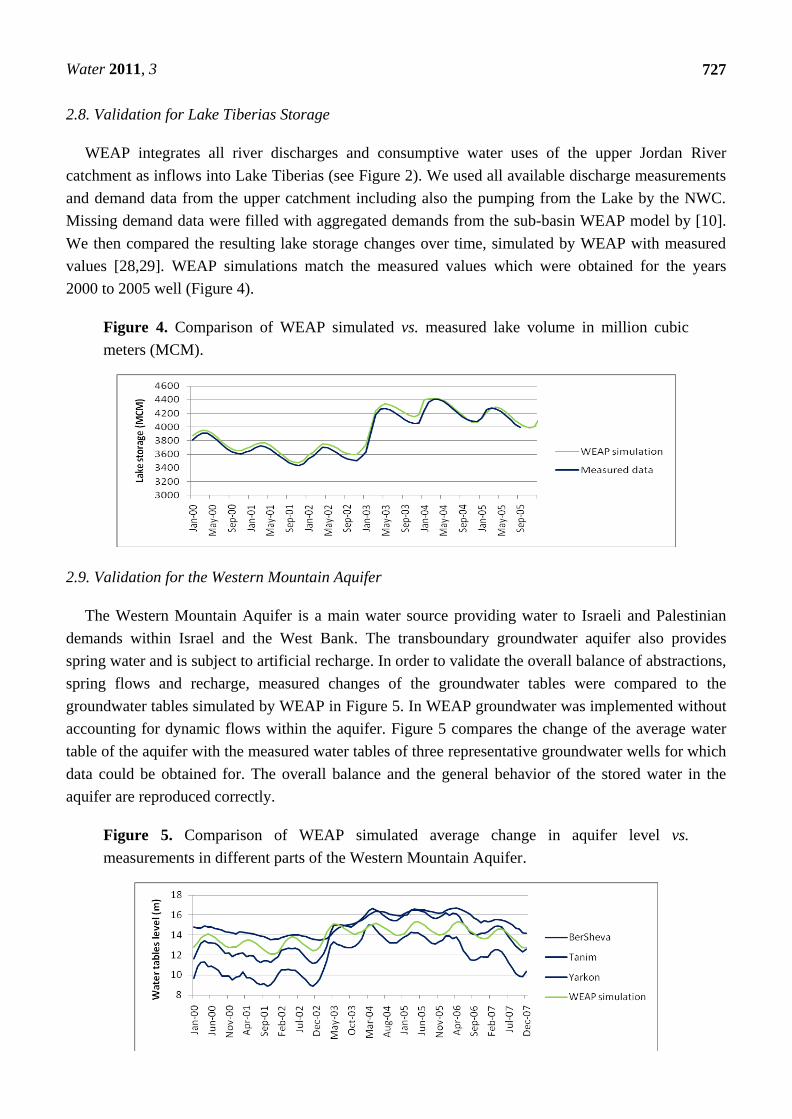
2.9. Validation for the Western Mountain Aquifer
The Western Mountain Aquifer is a main water source providing water to Israeli and Palestinian
demands within Israel and the West Bank. The transboundary groundwater aquifer also provides
spring water and is subject to artificial recharge. In order to validate the overall balance of abstractions,
spring flows and recharge, measured changes of the groundwater tables were compared to the
groundwater tables simulated by WEAP in Figure 5. In WEAP groundwater was implemented without
accounting for dynamic flows within the aquifer. Figure 5 compares the change of the average water
table of the aquifer with the measured water tables of three representative groundwater wells for which
data could be obtained for. The overall balance and the general behavior of the stored water in the
aquifer are reproduced correctly.
Figure 5. Comparison of WEAP simulated average change in aquifer level vs.
measurements in different parts of the Western Mountain Aquifer.

Water 2011, 3
728
In the lower Jordan below Lake Tiberias, validation against measured flows or storage is not yet
possible, but subject to ongoing GLOWA research. Due to excessive water withdrawals in the upper
Jordan and Yarmuk, discharge of the lower Jordan River has been reduced to less than 10% of the
natural flow [8]. The only remaining flow in the lower Jordan consists of aquifer inflows of unknown
quantity and highly polluted effluents, saline spring deviations and occasional flash floods. It cannot be
used yet to calibrate or validate the WEAP model.
2.10. Scenario Analysis with WEAP
The Jordan River WEAP model as described above allows for the analysis of various global change
and water management scenarios. Scenarios are self-consistent story-lines of how a future system
might evolve over time. These can address a broad range of "what if" questions [30]. This allows us to
evaluate the implications of different internal and external drivers of change, and how the resulting
changes may be mitigated by policy and/or technical interventions. For example, WEAP can be used to
evaluate the water supply and demand impacts of a range of future changes in demography, land use,
and climate. The result of these analyses can be used to guide the development of adaptation portfolios,
which are combinations of management and/or infrastructural changes that enhance the water
productivity of the system.
Initial supply-side scenarios within the WEAP model have been based on another sub-project of
GLOWA and the work of [31,32], who implemented outputs from the ECHAM 4 global climate model
and the MM5 regional climate model [33] in a hydrological model (TRAIN) to evaluate future water
availability as well as future irrigation water demand. While hydro-climatological scenarios based on
different emission scenarios, different global and regional climate models and different hydrological
impact models always span a wide range of future water situations, we have based this initial WEAP
analysis on the outcome of a ―middle-of-the-road‖ (i.e., the SRES A1B climate scenario which
assumes a moderate increase in greenhouse gas emission), according to which water supplies may be
reduced by 30 percent and irrigation water demand may increase by 22 percent by the middle of the
21st century compared to the 1990s. For the purposes of WEAP scenario development, these changes
were implemented in WEAP via linear reductions over time in mean annual discharge and
groundwater recharge for all supply nodes, and a linear increase in irrigation water demand for all
agricultural demand nodes.
This simplified approach presumes that the issues of water scarcity will magnify, while the pattern
of wet and dry years remains unchanged. In reality, droughts are likely to increase in frequency and
intensity [7], which may in fact pose more severe risks to the Jordan River water system than changes
in annual averages. To assess the vulnerability of the system to these changes, it will be necessary to
consider ensembles of scenarios that describe the full range of hydro-climatological variability.
Addressing the uncertainty associated with these projections and their impact on water management is
the focus of our ongoing research.
As part of yet another subproject of GLOWA, initial socio-economic scenarios of future water
demand are being developed jointly by scientists and stakeholders from all partner countries, in a
so-called Story And Simulation (SAS) approach [25, 30]. Based on agreed upon storylines and expert
judgment, population growth, economic development, and technological trends have been consistently
Water 2011, 3
729
projected into the future until the year 2050. The resulting four quantitative scenarios cover different
combinations of high or low economic growth and high or low degree of transboundary collaboration
over water. For each of the four scenarios, the resulting trends in water demand were calculated
separately for Israel, Jordan and the West Bank. To our knowledge, this is the only scenario exercise
for the Jordan River basin that combines qualitative expert knowledge with quantitative science-based
results. However, the development of these scenarios is an ongoing iterative process and the figures
presented here (Figure 6) are therefore provisional. Further scenario analysis will focus on different
adaptation options and their effectiveness under the global change scenarios described above.
3. Results
The Jordan River represents one of the most severe cases of a ―closed‖ basin [1], with all of its blue
water resources fully allocated and some severely overexploited. The Jordan River basin has
developed over the past half century into a very complex system of strongly interconnected water
supplies, demands and transmissions [34]. Several external and internal drivers of change are constantly
increasing pressure on the—mostly transboundary—water resources, while adaptation measures have
generally been implemented unilaterally and not across sectors.
The Jordan River WEAP system represents this situation at reduced complexity by aggregating
supplies and demands in a limited number of nodes and transmission links, based on the latest
available data from key national institutions such as the Jordanian Ministry of Water and Irrigation
(MWI), the Palestinian Water Authority (PWA) and Ministry of Agriculture (MoA) and the Israeli
Water Authority (IWA). Within the GLOWA project consistent demand and supply scenarios have
been developed in a continuous dialogue with these Israeli, Jordanian and Palestinian stakeholders and
based on state-of-the-art hydro-climatological scenarios. Implementing the results of these efforts
enables an initial comparison of the effects of future changes and adaptation options, as a basis for
more detailed analyses of specific management aspects. Representative for the type of analysis which
the Jordan River WEAP model enables–and which will be undertaken in future detailed studies, we
present in Figure 6 a projection of annual basin-wide unmet demands for four different socio-economic
demand scenarios (assuming no climate change) and one climate change scenario (assuming no change
in demand, except for climate driven increase in irrigation water demand) as described in the
methods chapter.
Water 2011, 3
730
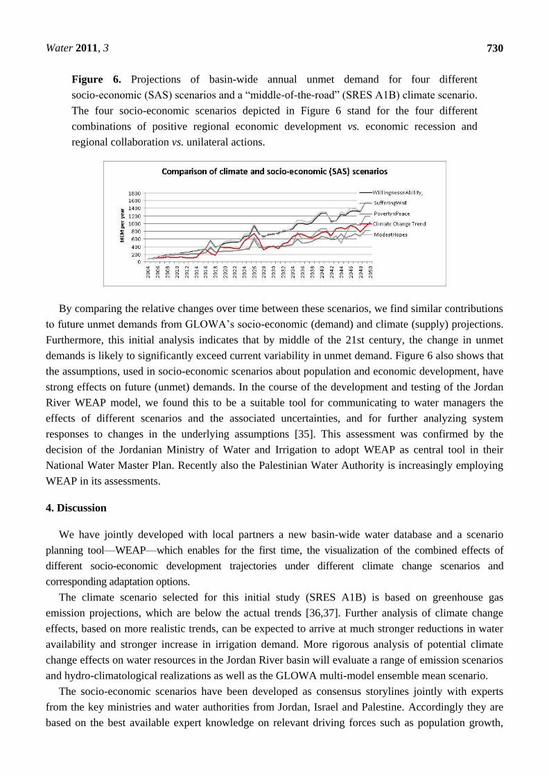
Figure 6. Projections of basin-wide annual unmet demand for four different
socio-economic (SAS) scenarios and a ―middle-of-the-road‖ (SRES A1B) climate scenario.
The four socio-economic scenarios depicted in Figure 6 stand for the four different
combinations of positive regional economic development vs. economic recession and
regional collaboration vs. unilateral actions.
By comparing the relative changes over time between these scenarios, we find similar contributions
to future unmet demands from GLOWA‘s socio-economic (demand) and climate (supply) projections.
Furthermore, this initial analysis indicates that by middle of the 21st century, the change in unmet
demands is likely to significantly exceed current variability in unmet demand. Figure 6 also shows that
the assumptions, used in socio-economic scenarios about population and economic development, have
strong effects on future (unmet) demands. In the course of the development and testing of the Jordan
River WEAP model, we found this to be a suitable tool for communicating to water managers the
effects of different scenarios and the associated uncertainties, and for further analyzing system
responses to changes in the underlying assumptions [35]. This assessment was confirmed by the
decision of the Jordanian Ministry of Water and Irrigation to adopt WEAP as central tool in their
National Water Master Plan. Recently also the Palestinian Water Authority is increasingly employing
WEAP in its assessments.
4. Discussion
We have jointly developed with local partners a new basin-wide water database and a scenario
planning tool—WEAP—which enables for the first time, the visualization of the combined effects of
different socio-economic development trajectories under different climate change scenarios and
corresponding adaptation options.
The climate scenario selected for this initial study (SRES A1B) is based on greenhouse gas
emission projections, which are below the actual trends [36,37]. Further analysis of climate change
effects, based on more realistic trends, can be expected to arrive at much stronger reductions in water
availability and stronger increase in irrigation demand. More rigorous analysis of potential climate
change effects on water resources in the Jordan River basin will evaluate a range of emission scenarios
and hydro-climatological realizations as well as the GLOWA multi-model ensemble mean scenario.
The socio-economic scenarios have been developed as consensus storylines jointly with experts
from the key ministries and water authorities from Jordan, Israel and Palestine. Accordingly they are
based on the best available expert knowledge on relevant driving forces such as population growth,

Water 2011, 3
731
economic and technological development, land use, etc. For a complete basin perspective, it would be
desirable to integrate the Lebanese and Syrian expertise and perspectives in future WEAP development.
Also based on the GLOWA stakeholder dialogues, a number of initial stylized adaptation options
have been included in this proof-of-concept Jordan River WEAP model, including:
Disi aquifer, assuming a transfer of 125 MCM/yr fossil groundwater to Amman, starting in
2015 [38]
Desalination along the Mediterranean coast, assuming a stepwise increase in desalination
capacity from currently about 250 to 700 MCM/yr by 2015, primarily for meeting demands in
the coastal cities
Red Sea–Dead Sea Conduit, assuming a delivery of 600 MCM/yr of desalinated water to
southern and middle Jordan and southern West Bank and Israel after 2020 [38]
Agricultural demand management, assuming a uniform reduction in agricultural demands by
50% (which would increase virtual water dependency from about 80% now to about 90%)
Municipal demand management, assuming a reduction of all losses by 50%, i.e., to a level
common in other regions of the world
Rainwater harvesting, assuming harvestable amounts per sub-catchment according to [39,40]
Wastewater treatment, assuming sufficient new treatment capacity in the north of Jordan and in
the West Bank to treat and reuse all municipal wastewater
However the analysis of the basin-wide and spatially explicit effects of these adaptation options is
still ongoing, so we cannot present results yet.
The integration of available supply and demand data with system linkages and feedbacks in a
consistent framework, as developed with the Jordan River WEAP model, will enable a new level of
IWRM planning, by assessing different combinations of local and global change effects and different
portfolios of adaptation as well as water reallocation options. The transparent structure and user-
friendly options for updating data and scenario assumptions provide a good basis for participatory and
problem-oriented analyses as well as for negotiations over reasonable and equitable water use such as
described in Brooks et al. [4].
Some of the limitations of our approach are related to the fact that collaboration/joint model
development and evaluation between Israeli, Palestinan, Jordanian partners and in particular with
Syrian/Lebanese partners is difficult or not possible at all for political reasons. While this is of limited
relevance at this stage for the Lebanese sub-basin, due to the low water resource development, the
omission in WEAP of detailed infrastructure development in Syria could be of concern [see e.g., 5].
For the moment, we have used uniform reduction in the flow rate of the Yarmuk River as a proxy.
Another limitation is the heterogeneous availability of water data across the basin, in particular for
groundwater data. We are addressing this gap by developing in GLOWA detailed WEAP-ModFlow
applications [41] and underlying detailed databases for individual aquifers. Furthermore the lack of
reliable projections of future climate variability [7] reflects in our WEAP simulations. We are only
now beginning to assess the full range of uncertainties across all climate scenarios and global and
regional climate models associated with changes in variability and annual averages.
Lastly, the specific situation of the lower Jordan, with only a few percent of the natural runoff
remaining, fed primarily by wastewater return flows, deviated saline spring discharge and occasional

Water 2011, 3
732
flash floods [8], does not currently allow a full hydrological validation. With the limited validation of
key system components, we can only show that we represent the major system components and
behavior correctly. For other details, our analysis represents more a sensitivity analysis than a
calibrated and validated simulation in a strict sense.
5. Conclusions and Outlooks
To our knowledge, this is the first trans-boundary, quantitative and spatially explicit scenario
analysis of the Jordan River water system under global change. It indicates that climate and
socio-economic change are both key drivers of future water scarcity in the basin. The fact that some of
the socio-economic scenarios result in higher, and others in lower, total unmet demands, compared to
the business-as-usual scenario, indicates that population and economic policies play a crucial role in
ensuring future water security in the Jordan River basin. The Jordan River WEAP model can support
more detailed policy analysis towards this end.
According to the WEAP principle of keeping the system representation as simple as possible
without losing the key structures and functions, water supplies and demands have been represented as
highly aggregated nodes. Based upon this initial Jordan River WEAP model, it is now possible to
specify system characteristics and processes in more detail—e.g., individual crops and their irrigation
requirements, technologies for improving water use efficiency, water quality restrictions for certain
uses, benefits from institutional change and related water reallocations, etc.—depending on the
question to be addressed.
We have limited the initial analysis of the Jordan River to the basic functions of WEAP, without
using its capabilities of simulating hydrological processes (―catchment nodes‖) or crop water use
(Mabia module) or coupling to a groundwater model (WEAP-ModFlow). These options will be used
for in-depth analyses of specific sub-systems of the Jordan River basin and mitigation potentials of
non-conventional water, wastewater re-use, green water use in rainfed and runoff agriculture, etc.
Further WEAP-based analyses will also address tradeoffs for different adaptation options, not only
in terms of the volumes of additional water generated or saved, but also for their affordability,
effectiveness, spatial distribution and degree of centralization. For example, small-scale distributed
rainwater harvesting and supplementary irrigation systems in combination with water savings in
agriculture, may increase resilience against future shocks and surprises through their inherent diversity
and redundancy [42,43], compared to a single large-scale water transfer scheme such as the planned
Red Sea—Dead Sea Canal (RDC). Future water system analyses with WEAP will also account for
improved green water management, which can help to reduce the pressure on blue water
resources [44,45].
Another important consideration in adaptation planning is the water-energy nexus. Given that the
Jordan River region is deficient in water and and at the same time in conventional energy resources
(not in solar energy though), the high energy intensity of adaptation options such as seawater
desalination or pumping of RDC water from below sea level to the highlands has to be taken into
account in future IWRM strategies. For possible integration of WEAP-based water assessments with
energy assessments see [46]. WEAP-based cost benefit analyses need to take future increases in energy
costs of different adaptation options into account.

Water 2011, 3
733
With that outlook, we invite further collaboration on WEAP-based assessments, tailored to the
respective analytical question and stakeholder requirements, and on improving the underlying Jordan
River data base, and thereby the reliability of the scenario analyses.
Acknowledgement
The authors are indebted to their colleagues from all GLOWA Jordan River sub-projects for their
contributions. The GLOWA Jordan River project is funded by the German Ministry of Science and
Education (BMBF) under the grant 01LW0501A1.
Further, the authors are grateful for very constructive comments by four anonymous reviewers.
References
1. Falkenmark, M.; Molden, D. Wake up to realities of river basin closure. Int. J. Water Resour. Dev.
2008, 24, 201-215.
2. Global Water Partnership (GWP). Integrated Water Resources Management—(TAC background
paper no. 4); GWP: Stockholm, Sweden, 2000.
3. Alan, J.A. The Middle East Water Question, Hydropolitics and the Global Economy; Tauris: New
York, NY, USA, 2001.
4. Brooks, D.; Trottier, J. A Modern Agreement to Share Water between Israelis and Palestinians,
the Friends of the Earth (FoEME) Proposal; FoEME: Amman, Jordan, 2010.
5. Phillips, D.J.H.; Jägerskog, A.; Turton, A. The Jordan River Basin: 3. Options for satisfying the
current and future water demand of the five riparians. Water Int. 2009, 34, 170-188.
6. Salameh, E. Overexploitation of groundwater resources and their environmental and socio-
economic implications: the case of Jordan. Water Int. 2008, 33, 55-68.
7. Bates, B.C.; Kundzewicz, Z.W.; Wu, S.; Palutikof, J.P. Climate Change and Water. Technical
Paper of the Intergovernmental Panel on Climate Change; IPCC Secretariat: Geneva, Switzerland,
2008; p. 210.
8. FoEME. Towards a Living Jordan: An Environmental Flow Report on the Rehabilitation of the
Lower Jordan River; FoEME: Amman, Jordan, 2010.
9. Sivan, I.; Salingar, Y.; Rimmer, A. A WEAP model of the Kinneret basin. Water Eng. 2007, 53,
50-58.
10. Almasri, M.N.; McNeill, L.S. Optimal planning of wastewater reuse using the suitability approach:
A conceptual framework for the West Bank, Palestine. Desalination 2009, 248, 428-435.
11. Haering, M.; Salman, A.; Al-Karablieh, E.; Gaese, H.; Al-Quran, S. Predicted Unmet Irrigation
Demands Due to Climate Change in the Lower Jordan River Basin. In Proceedings of the First
Arab WEAP Conference, Damascus, Syria, 25–27 May 2009.
12. Al-Omari, A.; Al-Quraan, S.; Al-Salihi, A.; Abdulla, F. A water management support system for
Amman Zarqa Basin in Jordan. Water Resour. Manage. 2009, 23, 3165-3189.
13. Haddad, M.; Jayousi, A.; Hantash, S.A. Applicability of WEAP as Water Management Decision
Support System Tool on Localized Area of Watershed Scales: Tulkarem District in Palestine as
Case Study. In Proceedings of the Eleventh International Water Technology Conference, Sharm
El-Sheikh, Egypt, 15–18 March 2007; pp. 811-825.
Water 2011, 3
734
14. Labadie, J.W.; Brazil, L.E.; Corbu, I. Computerized Decision Support Systems for Water
Managers; Johnson, L.E., Ed.; American Society of Civil Engineers: New York, NY, USA, 1989.
15. Zagona, E.; Fulp, T.; Shane, R.; Magee, T.; Goranflo, H. RiverWare: A Generalized tool for
complex reservoir systems modeling. J. Am. Water Resour. Assoc. 2001, 37, 913-929.
16. US Army Corps of Engineers (USACE). Hydrologic Engineering Center HEC-ResSim, Reservoir
System Simulation User’s Manual Version 2.0. CPD-82. USACE: Davis, CA, USA, 2003.
17. Randall, D.; Cleland, L.; Kuehne, C.; Link, G.; Sheer, D. Water Supply Planning Simulation
Model Using Mixed-Integer Linear Programming ‗Engine‘. J. Water Resour. Plann. Manage.
1997, 123, 116-124.
18. Yates, D.; Sieber, J.; Purkey, D.; Huber-Lee, A. WEAP21—A demand-, priority-, and preference-
driven water planning model: Part 1, Model characteristics. Water Int. 2005, 30, 487-500.
19. See website of Water Evaluation And Planning (WEAP) system. Available online:
http://www.weap21.org /index.asp?doc=05 (accessed on 11 June 2011).
20. De Condappa, D.; Chaponniere, A.; Lemoalle, J. A decision-support tool for water allocation in
the Volta Basin. Water Int. 2009, 34, 71-87.
21. Droubi, A.; Al-Sibai, M.; Zahra, S.; Obeissi, M.; Wolfer, J.; Huber, M.; Hennings, V.; Schelkes, K.
A Decision Support System (DSS) for Water Resources Management—Design and Results from a
Pilot Study in Syria. In Climatic Changes and Water Resources in the Middle East and North
Africa, Environmental Science and Engineering; Zereini, F., Hötzl, H., Eds.; Springer: Berlin,
Germany, 2008; pp. 199-226.
22. Hoellermann, B.; Giertz, S.; Diekkruger, B. Benin 2025—Balancing future water availability and
demand using WEAP System. Water Resour. Manage. 2010, doi:10.1007/s11269-010-9622-z.
23. Sandoval-Solis, S.; McKinney, D. Evaluation of Water Conservation Measures Implemented in
the Rio Grande/Bravo Basin. In Proceedings of World Environmental & Water Resources
Congressi, Providence, Rhode Island, USA, 16–20 May 2010; doi:10.1061/41114(371)212, 2010.
24. See website of the Ministry of Water and Irrigation. Available online: http://www.mwi.gov.jo/
sites/en-us/SitePages/National%20Water%20Plan.aspx (accessed on 12 June 2011).
25. Alcamo, J.; Onigkeit, J.; Lübkert, B.; Gramberger, M.; Koch, J.; Menzel, L.; Schaldach, R.;
Tielbörger, K. The Jordan River scenarios: Linking science and policy in a contentious setting.
Environ. Sci. Policy 2011, submitted for publication.
26. Executive Action Team (EXACT), Multilateral Working Group on Water Resources. Available
online: http://exact-me.org (accessed on 26 June 2011).
27. Allen, R.G.; Pereira, L.S.; Raes, D.; Smith, M. Crop Evapotranspiration—Guidelines for
Computing Crop Water Requirements; FAO Irrigation and Drainage Paper 56; FAO: Rome, Italy,
1998.
28. Assouline, S. Estimation of lake hydrologic budget terms using the simultaneous solution of water,
heat, and salt balances and a Kalman filtering approach—application to Lake Kinneret. Water
Resour. Res. 1993, 29, 3041-3048.
29. Rimmer, A.; Gal, G. The saline springs in the solute and water balance of Lake Kinneret, Israel.
J. Hydrol. 2003, 284, 228-243.
30. Alcamo, J.; Jakeman, A.J. Environmental Futures: The Practice of Environmental Scenario
Analysis; Elsevier: Amsterdam, The Netherlands, 2008.
Water 2011, 3
735
31. Menzel, L.; Koch, J.; Onigkeit, J.; Schaldach, R. Modelling the effects of land-use and land-cover
change on water availability in the Jordan River region. Adv. Geosci. 2009, 21, 73-80.
32. Menzel, L.; Teichert, E.; Weiss, M. Climate Change Impact on the Water Resources of the
Semi-Arid Jordan Region. In Proceedings of the 3rd International Conference on Climate and
Water, Helsinki, Finland, 3–6 September 2007; pp. 320-325.
33. Kunstmann, H.; Suppan, P.; Heckl, A.; Rimmer, A. Regional climate change in the Middle East
and impact on hydrology in the Upper Jordan catchment. IAHS Publ. 2007, 313, 141-149.
34. Van Aken, M.; Molle, F.; Venot, J.P. Squeezed Dry—the Historical Trajectory of the Lower
Jordan River Basin. In River Basin Trajectories: Societies, Environments and Development Cabi;
Molle, F., Wester, P., Eds.; CABI: Wallingford, UK, 2009; p. 311.
35. Bonzi, C.; Hoff, H.; Stork, J.; Subah, A.; Wolf, L.; Tielbörger, K. WEAP for IWRM in the Jordan
River Region. Bridging between scientific complexity and application. In Proceedings of the
Integrated Water Resources Management Conference, 24–25 November 2010, Karlsruhe,
Germany.
36. Le Quéré, C.; Raupach, M.R.; Canadell, J.G.; Marland, G.; Bopp, L.; Ciais, P.; Conway, T.J.;
Doney, S.C.; Feely, R.; Foster, P.; et al. Woodward Trends in the sources and sinks of carbon
dioxide. Nat. Geosci. 2009, 2, 831-836.
37. Friedlingstein, P.; Houghton, R.A.; Marland, G.; Hackler, J.; Boden, T.A.; Conway, T.J.; Canadell,
J.G.; Raupach, M.R.; Ciais, P.; Le Quéré, C. Update on CO2 emissions. Nat. Geosci. 2010, 3,
811-812.
38. Eng. Raed ABUSOUD, Minister of Water and Irrigation. Water for Life: Jordan’s Water Strategy
2008–2022; Eng. Raed ABUSOUD, Minister of Water and Irrigation: Amman, Jordan, 2009.
39. Lange, J.; Gunkel, A. Abschlussbericht: GLOWA Jordan River Phase 2—Teilvorhaben 5:
Hydrologische Modellierung (Blue Water). GLOWA Project Office: Tuebingen, Germany, 2009.
40. Shadeed, S.; Lange J. Rainwater harvesting to alleviate water scarcity in dry conditions: A case
study in Faria catchment, Palestine. Water Sci. Eng. 2010, 3, 132-143.
41. Abu Saada, M.; Sauter, M.; Massmann, J. Evaluating the Sustainability of Groundwater Aquifers
under Different Management and Climate Scenarios Using WEAP as a Tool, the Western Aquifer
Basin as a Case Study. Presentation at the WEAP workshop, Amman, Jordan, 2–4 May 2011.
42. Low, B.; Ostrom, E.; Simon, C.; Wilson, J. Redundancy and Diversity—do They Influence
Optimal Management? In Navigating Social-Ecological Systems—Building Resilience for
Complexity and Change; Berkes, F., Colding, J., Folke, C., Eds.; Cambridge University Press:
Cambridge, UK, 2003.
43. Chapin, S.; Carpenter, S.R.; Kofinas, G.P.; Folke, C.; Abel, N.; Clark, W.C.; Olsson, P.;
Stafford Smith, D.M.; Walker, B.H.; Young, O.R.; et al. Ecosystem stewardship: sustainability
strategies for a rapidly changing planet. Trends Ecol. Evol. 2009, 25, 241-248.
44. Evenari, M.; Shanan, L.; Tadmor, N. Evenari The Negev, the Challenge of a Desert; Harvard
University Press: Cambridge, MA, USA, 1991.
45. Oweis, T., Hachum, A. Water Harvesting for Improved Rainfed Agriculture in Dry Environments,
In Rainfed Agriculture—Unlocking the Potential; Wani, S.P., Rockström, J., Oweis, T., Eds.;
CABI: Wallingford, UK, 2009.

Water 2011, 3
736
46. Sieber, J., Heaps, C. Integrating WEAP and LEAP Tools for Modeling Energy-Water
Connections. In Proceedings of SEI Symposium, Medford, MA, USA, 4 November 2010;
Available online: http://www.sei-us.org/media/SEI-Symposium-2010_Heaps_Sieber.pdf (accessed
on 26 June 2011).
© 2011 by the authors; licensee MDPI, Basel, Switzerland. This article is an open access article
distributed under the terms and conditions of the Creative Commons Attribution license
(http://creativecommons.org/licenses/by/3.0/).