A View onto the World: Tenochtitlan, Travel and Utopia in the...
114
A View onto the World: Tenochtitlan, Travel and Utopia in the Early Modern Period Krystel Chéhab Department of Art History and Communication Studies McGill University, Montreal August 2007 A thesis submitted in partial fulfilment of the requirements of the degree of the Master of Arts © Krystel Chéhab 2007
Transcript of A View onto the World: Tenochtitlan, Travel and Utopia in the...

A View onto the World: Tenochtitlan, Travel and Utopia in the Early Modern Period
Krystel Chéhab
Department of Art History and Communication Studies McGill University, Montreal
August 2007
A thesis submitted in partial fulfilment of the requirements of the degree of the Master of Arts
© Krystel Chéhab 2007

Table of Contents
Table of Contents ............................................................................................................. 2 List of Figures .................................................................................................................. 3 Acknowledgments............................................................................................................ 4 Abstract ............................................................................................................................ 5 Résumé ............................................................................................................................. 6 Introduction ...................................................................................................................... 7
Venice and Historiography .......................................................................................... 8 The Chapters .............................................................................................................. 14
Chapter One - The Cortés Map of 1524: The Archetypal Image of Tenochtitlan ......... 18 First Appearances: The Revelatory Effect ................................................................. 18 Historiography ........................................................................................................... 22 Mapping Trends ......................................................................................................... 25 Urban Forms: A Fish-eye Perspective of Tenochtitlan ............................................. 29 Architecture, Bodies, and Script: The Precinct as Stage ........................................... 34 Figures of the Frame .................................................................................................. 37
Chapter Two - Insular Topographies: Tenochtitlan, Venice, and the Mirroring Effect in Benedetto Bordone’s Libro ............................................................................. 43
Historiography ........................................................................................................... 45 The Isolarii as Genre: Cristoforo Buondelmonti and Bartolomeo dalli Sonetti ........ 48 Receding Horizons: Benedetto Bordone’s Libro and the Islands in the Atlantic ...... 51 A Play of Resemblances between Tenochtitlan and Venice ...................................... 54 Histories of Origins, Toponyms and Venice ............................................................. 56 Islands and Christianity ............................................................................................. 62
Chapter Three - Re-envisioning Venice: Giovanni Battista Ramusio’s Navigationi e Viaggi and the ‘Iconic’ View of Tenochtitlan ............................................................. 67
Historiography and Historical Background ............................................................... 69 Navigationi e Viaggi: Text, Image, and Memory ...................................................... 73 Utopian Interests ........................................................................................................ 80 Venice and the Lagoon .............................................................................................. 83 Perspectival Shifts: Re-imagining the Bacino of San Marco .................................... 87
Conclusion ..................................................................................................................... 93 Figures............................................................................................................................ 96 Bibliography ................................................................................................................ 106
2
List of Figures
I. Figure 1: La gran ciudad de Temixtitan (Tenochtitlan, 1524). Praeclara
Fernanandi di Nova Maris Oceani Hispania Narratio (Nuremberg, 1524).
II. Figure 2: Jacopo de’Barbari, Venetie. Printed by Anton Kolb (Venice, 1500).
III. Figure 3: Venetia, Benedetto Bordone, Libro di Benedetto Bordone
(Venice, 1528). IV. Figure 4: La gran città di Temixtitan, Benedetto Bordone, Libro di
Benedetto Bordone (Venice, 1528).
V. Figure 5: Temistitan, Giovanni Battista Ramusio, Terzo Volume delle Navigationi e Viaggi (Venice, 1528).
VI. Figure 6: Nova Mexico, Arnoldus Montanus, De Nieuwe en Onbekende
Weeereld (Amsterdam, 1671). VII. Figure 7: Konrad Morant, View of Strasbourg, 1548. Germanisches
Nationalmuseum, Nuremberg.
VIII. Figure 8: Detail, La gran ciudad de Temixtitan (Tenochtitlan, 1524). Praeclara Fernanandi di Nova Maris Oceani Hispania Narratio (Nuremberg, 1524).
IX. Figure 9: Pourtrait et Description de la grand cite de Temistitan, ou,
Tenuctutlan, ou selon aucuns Messico, ou, Mexico, ville capitale de la Nueva Espaigne, Antoine Du Pinet, Plantz, Pourtraitz et Descriptions de plusieurs villes et forteresses, tant de l’Europe, Asie, & Afrique, que des Indes et terres neuves (Lyon, 1564).
X. Figure 10: Mexico, Georg Braun, Civitates orbis terrarum (Cologne,
1572).
3

Acknowledgments
I would like to thank my advisor, Bronwen Wilson, for her enthusiasm and
encouragement, and for the continued generosity of her knowledge and time. Her
intellectual insight has probed me to think about this project and art history as a
discipline in new ways. The Department of Art History and Communication
Studies and the Making Publics project have provided important forums for the
exchange of ideas. I am grateful to my colleagues, and friends, for making
graduate school at McGill a challenging and positive experience, with a special
thanks to Anu, Ariana, and Gab. Thanks to Sonia for helping me with the
translation. A warm thanks to my family, in Miami and in Montreal, and
especially to Linda, Emile and Carine, for their optimism, love, and
encouragement. I am thankful for the generosity of Leila and Alex who opened
their doors to me. To Gorka for his unfailing support throughout.
4

Abstract
This thesis examines the Cortés map of Tenochtitlan (1524) and its derivatives to
explore the ways the map emerges in diverse forms, and in different contexts,
throughout the sixteenth century. For nearly two hundred years, the only images
of Tenochtitlan, or Mexico City, to be published in Europe were derived from the
original Cortés map, which represented the city before its conquest by the Spanish
in 1521. The maps of Tenochtitlan included in Benedetto Bordone’s Libro di
Benedetto Bordone nel quale si ragiona tutte l’Isole del mondo (1528) and
Giovanni Battista Ramusio’s Navigationi e Viaggi (1556) brought the city into
dialogue with Venice, encouraging viewers to interpret the two together. As
Venice shifted from its traditional maritime economy to land ventures on the
mainland in the sixteenth century, its citizens looked to the island city of
Tenochtitlan to rethink their city’s own lagoonal environment. Tenochtitlan’s
insular topography invited new possibilities for re-imagining Venice in utopic
terms. However, with the fall of Tenochtitlan, the printed imagery in Europe
evoked a city that was rapidly being transformed into another, Mexico City, under
Spanish rule. It was the visual experience of Tenochtitlan in images, rather than
the real city they claimed to represent, that would prompt a re-envisioning of
Venice.
5
Résumé
Ce mémoire propose un examen de la carte géographique de Tenochtitlan
élaborée par Cortés en 1524 et de ses dérivés afin d’évaluer comment cette carte
s’est révélée sous diverses formes, et dans différents contextes au cours du
seizième siècle. Pendant plus de deux cents ans, les seules images de
Tenochtitlan, ou Mexico, à être publiées en Europe dérivent de la carte de 1524
qui représente la ville avant la conquête espagnole de 1520. Les cartes de
Tenochtitlan incluses dans le Libro di Benedetto Bordone nel quale si ragiona
tutte l’Isole del mondo de Benedetto Bordone (1528) et Navigationi e Viaggi de
Giovanni Battista Ramusio (1556) mettent la capitale aztèque en dialogue avec
Venise, encourageant ainsi les lecteurs à interpréter les deux parallèlement.
Lorsque, au seizième siècle, l’économie vénitienne, traditionnellement maritime,
se tourne vers le commerce continental, les Vénitiens se tournent à leur tour vers
la ville insulaire de Tenochtitlan pour repenser l’environnement lagunaire de leur
ville. La topographie insulaire de Tenochtitlan offre de nouvelles manières
d’envisager Venise en des termes utopiques. Toutefois, après la chute de
Tenochtitlan, l’imagerie imprimée circulant en Europe évoque d’ors et déjà une
ville en devenir, Mexico, une ville sous le joug espagnol. Les images de
Tenochtitlan, plutôt que la vraie ville qu’elles clament représenter, procurent une
expérience visuelle qui entraîne une nouvelle visualisation de Venise.
6

Introduction
Upon his arrival in Mexico in 1519, Bernal Diaz de Castillo, a companion
of the Spanish conquistador Hernán Cortés, was struck by the arresting view of
Tenochtitlan, or present-day Mexico City, as it revealed itself at the centre of
Lake Texcoco. From his vantage point on the outer shores, the city’s unfamiliar
temples and towers created a visual spectacle that compelled Diaz to write,
“…one has to marvel at it all so much that I do not know how to describe it,
seeing things never heard of, seen or even dreamed of...”1 At a moment when
voyages of discovery were rapidly changing the contours of the earth, as
Europeans conceived them, sixteenth-century travelers were charged with
describing unknown worlds, such as Tenochtitlan, for their audiences back home.
As far-flung places began to emerge on the horizon, they were often accessible to
Europeans only through representation, in both textual and graphic forms. While
Diaz represented Tenochtitlan in text, an extraordinary map-view – the Cortés
map of 1524 - presented Europeans with a visual image of Tenochtitlan (fig. 1).
The Cortés map offered viewers an image of the island city circumscribed
within the contours of a blue circular lake. In 1520, shortly after Hernán Cortés
entered the capital city of Tenochtitlan, he dispatched his Second Letter to the
Emperor Charles V. Enclosed with the letter is believed to have been a prototype,
now lost, that provided the European artist of the Cortés map with a model of
1 I am drawing here on the English translation in David A. Boruchoff, “Beyond Utopia and Paradise: Cortés, Bernal Diaz, and the Rhetoric of Consecration,” MLN 106, no. 2 (1991): 331. See also Bernal Diaz del Castillo, Historia verdadera de la conquista de la Nueva España, ed. Miguel León-Portilla (Madrid: Historia 16, 1984), A, 310-311.
7

Tenochtitlan.2 First printed in Nuremberg in 1524, the Cortés map would soon
become the archetype for a number of derivative images of the remote city.
Indeed, throughout the century, Europeans eager to gain visual access to
Tenochtitlan would only encounter the Cortés map in its diverse replications.
Derived from a single source, images of Tenochtitlan, as they emerged in island
books and travel narratives, elicited new ways of thinking about the relationship
between cities and their surroundings.
Venice and Historiography
Intriguingly, Tenochtitlan came to be compared to, and hold particular
resonance for, Venice, another city with a striking insular topography. In his
isolario, or book of islands, published in 1528, Benedetto Bordone is attentive to
the topographical similarities between Tenochtitlan, a city among new worlds,
and his adopted city of Venice.3 Although the two were removed geographically
from each another across the ‘Ocean Sea,’4 as the Atlantic was conceived, that
Tenochtitlan was built on water, at the centre of a lake, solicited its interpretation
as a city “like Venice.” 5 This pairing of Tenochtitlan with Venice, and the
implications it comes to have for sixteenth-century Venetians, forms the basis of
my study.
2 For a discussion of the prototype, see Barbara E. Mundy, “Mapping the Aztec Capital: The 1524 Nuremberg Map of Tenochtitlan, Its Sources and Meanings,” Imago Mundi, 50 (1998): 11-33. 3 Bordone is originally from Padua. For his biography and career as a miniaturist, see Lilian Armstrong, “Benedetto Bordone, ‘Miniator’, and Cartography in Early Sixteenth-Century Venice,” Imago Mundi 48 (1996): 65-92. 4 This was according to the tricontinental understanding of the globe inherited from the ancients. See Denis Cosgrove, Apollo’s Eye: A Cartographic Genealogy of the Earth in the Western Imagination (Baltimore: Johns Hopkins University Press; Santa Fe, N.M.: The Center for American Places, 2001). 5 Benedetto Bordone, Il Libro di Benedetto Bordone, Venice, Nicolò Zoppini, 1528, fol. VIIv. For the English translation, see Armstrong, “Benedetto Bordone, ‘Miniator,’” 90n98.
8
Bordone is not alone is associating the cities together; a collection of
visual and textual references link the two insular topographies in the early modern
period.6 Floating in the centre of the lagoon as a series of interconnecting islands,
Venice stands at the crossroads between Europe and Asia. As the gateway to the
Levant, the mercantile city of Venice had long enjoyed strong ties to Byzantium,
and an established history of trade relations with the East.7 Unlike other cities on
the Italian peninsula with visible remnants of a Roman past, Venice was pressed
to solidify its history of origins, a feat that became increasingly important in the
sixteenth century. This myth of origins, a topic that has been addressed by
scholars such as Edward Muir, among others, claimed that Roman elites on the
mainland, who sought refuge in the lagoon from religious persecution, established
the city of Venice. 8 This celebrated past was compounded by the claim that
Venice was founded at the church of San Giacomo in Rialto, at the centre of
Venice, on March 25, 421, on the Feast of the Annunciation. In this respect, the
city could claim historical origins from both republican Rome and early
Christianity.9 These legendary beginnings, as Patricia Fortini Brown conceives it,
along with the translation of Saint Mark’s body to Venice in 828 and the Peace of
6 For examples, see David Y. Kim, “Uneasy Reflections: Images of Venice and Tenochtitlan in Benedetto Bordone’s Isolario,” Res 49-50 (2006): 81-82.
See Deborah Howard, Venice & the East: The Impact of the Islamic World on Venetian Architecture, 1100-1500 (New Haven: Yale University Press, 2000); and Brian Pullan, ed., Crisis and Change in the Venetian Economy in the Sixteenth and Seventeenth Centuries (London: Methuen, 1968). 8 For the historiography of the myth of Venice, see Edward Muir, Civic Ritual in Renaissance Venice (Princeton, N.J.: Princeton University Press, 1981). 9 Patricia Fortini Brown, Art and Life in Renaissance Venice (New York: Harry N. Abrams, 1997), 16-17.
9

Venice in 1177, can be understood as three “iconic narratives” that forged the
myth of Venice.10
As scholars have effectively argued, maps of Venice were complicit in
rehearsing the myth of origins. Elisabeth Crouzet-Pavan examines the histories of
the islands of the lagoon, such as Torcello, to suggest the ways they are forgotten
in order to place the Republic’s mythic beginnings in Rialto, at the centre of
Venice (1994).11 For Crouzet-Pavan, the process of overlooking these histories
becomes apparent in maps such as Jacopo de’Barbari’s View of Venice (1500) and
Benedetto Bordone’s Venice (1528), which privilege the centre while
marginalizing the islands of the lagoon (figs. 2 and 3). Juergen Schulz, in his
earlier study of Jacopo’s View of Venice, is interested in the ways the map came to
emphasize certain facets of the city, specifically those that symbolized its
republican institutions, to promote an idea of Venice as commonwealth (1978).12
Venice’s ideal constitution, which comprised elements of monarchy, oligarchy
and democracy, was to ensure a balanced government where individual powers
would be mitigated. For Venetians, the city’s republican institutions, in addition
to its isolated geographic location, secured its liberty from outside aggression,
sustaining the longevity of the Republic.13
10 Patricia Fortini Brown, “The Self-Definition of the Venetian Republic,” in City States in Classical Antiquity and Medieval Italy eds. Anthony Molho, Kurt Raaflaub, Julia Emlen (Ann Arbor: University of Michigan Press, 1991), 512. 11 Elisabeth Crouzet-Pavan, “Venice and Torcello: History and Oblivion,” Renaissance Studies 8, no. 4 (1994): 416-427. 12 Juergen Schulz, “Jacopo de’ Barbari’s View of Venice: Map Making, City Views, and Moralized Geography before the Year 1500,” The Art Bulletin 60, no. 3 (1978): 468. 13 Gaetano Cozzi, Ambiente Veneziano, Ambiente Veneto. Saggi su politica, società, cultura nella Repubblica di Venezia in età moderna (Venice: Marsilio, 2002).
10

In the early years of the sixteenth century, external events propelled
Venice to re-evaluate its relationship to its seafaring past. 14 In 1453,
Constantinople fell to the Ottoman Turks who came to dominate trade relations in
the Aegean Sea. The Portuguese discovery of trade routes to the East posed a
serious threat to Venice’s already weakening economy. In 1509, the League of
Cambrai, an agglomeration of European powers weary of Venetian expansionism,
joined forces to overtake its territories on the terrafirma, though these lands were
eventually regained by Venice. As the century progressed, Venetians began to
reorient themselves away from the Eastern Mediterranean towards their territories
on the mainland, shifting their focus from the historical stato del mar to an
agricultural-based economy on the terrafirma.15 Denis Cosgrove, in his discussion
of Venetian interests in the terrafirma, examines the imperative role played by
maps in these ventures, and the ways maps were implicated in the routinely affairs
of the Republic.16 He is also attentive to how maps become linked with other
modes of representation in Venice, specifically in relation to representations of
landscapes (1992, 1984).17
While Venice did not participate directly in the explorations of new
worlds, the steady flow of travel accounts into the city, due to its reputation as a
foremost centre of print, created a forum for geographical knowledge, especially
14 Denis Cosgrove, “Venice, the Veneto and Sixteenth-century Landscape,” in Social Formation and Symbolic Landscape (London and Sydney: Croom Helm, 1984), 108. 15 Ibid. 16 Denis Cosgrove, “Mapping New Worlds: Culture and Cartography in Sixteenth-Century Venice,” Imago Mundi, 44 (1992): 71-72. 17 See Cosgrove, Social Formation and Symbolic Landscape.
11

among Venetian humanists like Giovanni Battista Ramusio.18 The new visibility
afforded by the printing press diffused knowledge of recently encountered lands
across broader audiences. The multiple island books, travel narratives, and atlases
published in Venice during the sixteenth century kept citizens abreast of
discoveries of unknown worlds. Likewise, printmakers in Venice produced
images of their native city, often in commemoration of important civic events, and
sold them in large numbers to visitors.19 As Bronwen Wilson suggests in her
study of printed maps, the numerous print shops stationed in Venice, with images
on display in their windows, would have familiarized Venetians with the shape of
their city. 20 Wilson is interested in the ways the visual experience of print
overlapped with Venetians’ experiences of the city, and the ways identity
becomes constituted in this process (2005). The innovations of print also
publicized travellers’ accounts in the Mediterranean, a geographic location that
would have undoubtedly resonated with Venetians. Deborah Howard’s studies of
Venetians in Damascus in the fifteenth century (2003) and Patricia Fortini
Brown’s book on the seafaring adventures of Cristoforo Buondelmonti and
Cyriacus of Ancona, among others, (1996) are two examples of art historical
works that engage with Venice’s relations with the East.21
18 R.A. Skelton, introduction to Giovanni Battista Ramusio, Navigationi e Viaggi, 1563-1606 (Amsterdam: Theatrum Orbis Terrarum, 1967-1970), v. 19 David Woodward, Maps as Prints in the Italian Renaissance: Makers, Distributors & Consumers (London: British Library, 1996), 83. 20 Bronwen Wilson, “From Myth to Metropole: Sixteenth-Century Printed Maps of Venice,” in The World in Venice: Print, The City, and Early Modern Identity (Toronto: University of Toronto Press, 2005), 60. 21 See Deborah Howard, “Death in Damascus: Venetians in Syria in the mid-Fifteenth Century,” Muqarnas 20 (2003): 143-57; Francesco Bianchi and Deborah Howard, “Life and Death in Damascus: The Material Culture of Venetians in the Syrian Capital in the mid-Fifteenth Century,” Studi Veneziani 46 (2003): 233-300; Deborah Howard, “The Status of the Oriental Traveller in
12

While these ties with the East are deeply sewn along historical lines, and
have important implications in the formation of identity in sixteenth-century
Venice, my project, instead, is interested in the ways new worlds in the Atlantic,
specifically the island city of Tenochtitlan, come to play a role in Venice at a
moment when the city is turning away from its traditional stato del mar towards
land ventures on the terrafirma. I examine how Tenochtitlan is mobilized within
representation, in different formats and outlets, to petition Europeans, in general,
and Venetians, in particular, to view the two cities together. While I first address
the Cortés map, the two chapters that follow consider the ways the derivative
images of Tenochtitlan bring the city into dialogue with Venice, prompting
Venetians to re-envisage their own insular topography.
In recent years, scholars have interrogated the objectivity of maps,
recognizing them as graphic representations whose meanings are often
manipulated. Maps of the Spanish Americas, which were produced in Europe, had
important repercussions for the peoples and places they claimed to represent. As
J.B. Harley has effectively argued, sixteenth-century maps had the potential to
‘silence’ the realities of the Americas for European viewers (1988).22 Walter
Mignolo is attentive to the ways that maps are complicit in colonizing processes.
Developments in European cartography, prompted, in part, by the rediscovery of
Ptolemy’s Geographia, formulated a distinction between the Ptolemaic grid,
Renaissance Venice,” in Re-Orienting the Renaissance: Cultural Exchanges with the East, ed. Gerald MacLean (Basingstoke and New York: Palgrave Macmillan, 2005), 29-49; and Patricia Fortini Brown, Venice & Antiquity: the Venetian Sense of the Past (New Haven: Yale University Press, 1996). 22 See J.B Harley, “Silences and Secrecy: The Hidden Agenda of Cartography in Early Modern Europe,” Imago Mundi 40 (1988): 57-76; and J.B. Harley, “Rereading the Maps of the Columbus Encounter,” Annals of the Association of American Geographers 82, no. 3: 543-65.
13

employed by Europeans, and indigenous representations of space. Mignolo
suggests that Europeans maps were naturalized as truthful representations while
indigenous spatial codes were effectively repressed (1995).23 The Cortés map of
Tenochtitlan has also been studied in this light. José Rabasa (1993) and Barbara
E. Mundy (1998) have identified different ways the map participated in
colonizing processes that subjugated the Aztec ruler Moctezcuma to European
rule.24
The Chapters
Alternatively, my study is concerned with how the single image of
Tenochtitlan, first represented in the Cortés map of 1524, migrates between
different contexts, and manifests in diverse forms, to conjure an idea of
Tenochtitlan in the geographical imagination of Europeans. The first chapter
examines the ways the Cortés map functions on two levels. In the age of
explorations, when new worlds were often associated with amorphous terrains,
the Cortés map vigorously attempts to carve out a place in this ambiguity. As
Rabasa aptly notes, “…the plan of the city [of Tenochtitlan] infuses newness into
what otherwise would be solely the contours of a coastline without a semantic
difference.” 25 As a representation of a city that few viewers would have the
opportunity to experience, the visual imagery was charged with evoking a vivid
sense of place. While the map calls attention to the specificity of Tenochtitlan, it
also serves as the archetype for future images of the city. Remarkably, for almost
23 Walter D. Mignolo, The Darker Side of the Renaissance: Literacy, Territoriality, and Colonization (Ann Arbor: The University of Michigan Press, 1995), 243. 24 José Rabasa, Inventing America: Spanish historiography and the formation of Eurocentrism (Norman: University of Oklahoma Press, 1993); and Mundy, “Mapping the Aztec Capital.” 25 Rabasa, Inventing America, 100.
14

two hundred years, the Cortés map bracketed an idea of a place, in the minds of
Europeans, far-removed from the real city it claimed to represent.
Venetian travel writers, as Deborah Howard explains, often described
unknown places by comparing them to sites within Venice.26 Introducing the
unfamiliar into the framework of the familiar was a means of gaining knowledge
in the early modern period that, as scholars have argued, becomes prevalent in
explorations of the Americas, since travelers were confronted with things never
before seen.27 In sixteenth-century maps of Tenochtitlan, European artists were
undoubtedly drawing on their knowledge of other island cities, such as Venice,
and ideal city plans, which were largely popular in Europe. For Benedetto
Bordone, Venice’s insular topography becomes a basis of comparison for
Tenochtitlan. In Bordone’s Libro, whose island book format tended to emphasize
outer contours, the play of resemblances between the two cities is magnified. If
the wealth of print shops in Venice allowed citizens to identify the outlines of
their city, as Wilson suggests, then presenting them with a distant city in the new
world that mirrored their own raised important questions. In chapter two, I
examine how the mirroring effect between Tenochtitlan and Venice in Bordone’s
Libro brings forward the otherness of Tenochtitlan. This otherness, underwritten
by the elusive origins of the new world, crystallizes around acute temporal and
religious issues that plagued sixteenth-century Europeans.
26 Howard, “The Status of the Oriental Traveller,” 32. 27 See Karen Ordahl Kupperman, “Introduction,” in America in European Consciousness, ed. Karen Ordahl Kupperman (Chapel Hill: University of North Carolina Press, 1995), 1.
15
If Tenochtitlan was originally represented in the guise of a European ideal
city, one that mimicked Venice’s own insular topography, in Bordone’s Libro,
Giovanni Battista Ramusio’s map of Tenochtitlan (1556) signals a considerable
shift in perspective. By mid-century, as Venice moved towards an agricultural-
based economy on the terrafirma, it was obliged to redefine its precarious
relationship to its lagoonal surroundings. In chapter three, I examine how the map
of Tenochtitlan included in Ramusio’s travel collection, Navigationi e Viaggi,
brings forward concerns in Venice over the future of the lagoon. I look to the
famous debates between Alvise Cornaro and Cristoforo Sabbadino with an
interest in how Tenochtitlan becomes a model for solutions to water management.
While Tenochtitlan had previously been conceived in relation to its resemblance
to Venice, it was now Venice, in these unrealized projects for the lagoon, that
came to re-imagine itself as its new world counterpart.
Intriguingly, however, the images that fuelled comparisons between
Venice and Tenochtitlan - and eventually compelled Venetians to re-envision
their city in new ways – represented a place that no longer existed. Indeed, while
images produced in Europe throughout the sixteenth century visualized the city of
Tenochtitlan, it had long commenced its transformation into Mexico City, a place
that no longer had a purpose for the canals that Venetians scrutinized so
intently. 28 While Mexico City emerged across the Atlantic, the Cortés map
actively participated in shaping perceptions in Europe. For close to two centuries,
28 Beginning in the 1550s, the canals were filled to support the expanding colonial city under Spanish rule. See Richard L. Kagan, Urban Images of the Hispanic world, 1493-1793 (New Haven: Yale University Press, 2000), 90.
16

17
the single image of Tenochtitlan and its multiple derivatives, including those of
Bordone and Ramusio, were the only images to be published.29 It is from this
archetypal image - the Cortés map of 1524 - that my study begins.
29 Ibid., 89.

Chapter One - The Cortés Map of 1524: The Archetypal Image of Tenochtitlan
In 1522, the preface to the first edition of Hernán Cortés’ Second Letter
urged Europeans to envision one among many cities in the Aztec world. Published
in Seville, by Jacobo Cromberger, the preface reads, “Among these cities there is
one more marvellous and more wealthy than all the others, called Temixtitan
[Tenochtitlan]...”1 Two years later, in 1524, Cortés’ letter was translated into Latin
by Pietro Savorgnani de Foli and published in Nuremberg.2 Readers of the Latin
edition were now presented with an extraordinary map-view of Tenochtitlan that
revealed an island city floating within the contours of a blue circular lake (fig. 1).
The Latin edition introduced Cortés’ quests to broader European audiences, and,
like its earlier counterpart, encouraged a particular interest in Tenochtitlan. Indeed,
instead of relying solely on textual allusions to “the great city of Temixtitan” that
punctuated Cortés’ Second Letter, Europeans were also engaged by the visual
experience of the map. This map, the Cortés map of 1524, would forge a lasting
idea of Tenochtitlan, in Europe, through its replications in print.
First Appearances: The Revelatory Effect
The strategic placement of the Cortés map heightened its revelatory effect.
1Hernan Cortés, Letters from Mexico, trans. and ed. A.R. Pagden. (New York: Grossman, 1971), 47. Citations are from this edition. For a discussion of the name of Tenochtitlan, see George Kubler, “The name ‘Tenochtitlan,’” Tlalocan I (1944): 376-377. 2A.R. Pagden, ‘Translator’s Introduction,’ in Hernan Cortés, Letters from Mexico, 1x. Federic Peyrus printed this edition of the Second Letter and Cortés map of Tenochtitlan (1524). For different editions of the map, see Mundy, “Mapping the Aztec Capital,” 32.

In the opening pages of the Latin edition of the Second Letter, a pleated folio,
which hid the map, divulged its contents when unfolded.3 The map’s oversize
dimensions required its compression and the reader to open it, making the
revelatory process a haptic one. As one of the first urban images to emerge from
the Atlantic world, the process of unveiling the map actively petitioned Europeans
to inspect the unknown city and scrutinize it closely. For these individuals, the
image granted visual access to a city beyond their own; it encouraged them to
envision a place that was absent in time and space.4 Roger Chartier, in his study of
print culture, is attentive to the ways a book’s formal elements establish a protocol
that organizes how the book is read.5 As Chartier suggests, “The book always aims
at installing an order.”6 Positioned in the book’s opening pages, the Cortés map
formed part of a mnemonic system that constructed an idea of Tenochtitlan that
preceded readers’ encounters with the text.7 Through the order of the book, the map
impresses an image of a place, one that becomes slowly populated with peoples and
events as readers progress through the Second Letter.
Set in the centre of Lake Texcoco, the map reveals a striking square-
shaped temple precinct hemmed into its cityscape by interlocking islands and
3 Praeclara Ferdinãdi. Cortesii de Nova maris Oceani Hyspania Narratio…(Nuremberg, 1524) The map is located between page ii and iii. For the placement of the Cortés map in other editions, see Mundy, “Mapping the Aztec Capital,” 32. 4 Kagan, Urban Images, 73. Scholars recognize the earlier View of Hispaniola woodcut that was paired with Columbus’ De insulis in mari Indico nuper inventis (1494) as the first city map of the Atlantic world. However, while this image reveals the contours of the Spanish settlement of La Isabella, it was based on the textual accounts of Columbus’ letter and thus conceived exclusively in the imagination of the artist. 5 Roger Chartier, ed. The Culture of Print: Power and the Uses of Print in Early Modern Europe, trans. Lydia Cochrane (Princeton, NJ: Princeton University Press, 1989), 5. 6 Roger Chartier, Order of Books: Readers, Authors, and libraries in Europe between the fourteenth and eighteenth centuries, trans. Lydia Cochrane (Cambridge: Polity Press, 1994), viii. 7 Chartier, The Culture of Print, 5.
19

narrow waterways. From this central precinct, past the robust walls that enclose
the sacred space, clusters of adjoining red-roofed houses populate the surrounding
islands. Arranged in a circular formation, with the temple precinct at its core, the
islands present the city as a unified whole. The islands, along with the figures that
circumnavigate the lake in canoes, propel viewers to trace Tenochtitlan’s
outermost shores, which delineate the city’s well-defined contours in the middle
of the lake.
Struck by the enormity of the temple precinct, Hernán Cortés was
compelled to draw an analogy for Europeans; in his Second Letter, he writes,
“There is also one square twice as big as that of Salamanca….”8 In the map, the
precinct’s unfamiliar configuration of figures and shapes are sharply outlined in
black on a smooth white surface. The Templo Mayor is formed by two central
twin pyramids, connected at the baseline, and situated in the upper, or west, end
of the precinct. Drawn in elevation, and presented as the reverse of its counterpart,
each pyramid is formed by an ascending staircase and an adjoining tower, and
each holds a shrine accessible from the pyramid’s summit.9 Compressed in the
aperture between the two pyramids, a human face, detached from his naked body
below, announces the temple as the foremost site of human sacrifice in
Tenochtitlan.
From each of the precinct’s portals, four principal causeways radiate
outward along rectilinear axes, transporting observers across the lake to the
modest lakeside cities that reside on the outer shores. If drawn first to the
8 Cortés, Letters from Mexico, 103. 9 Mundy, “Mapping the Aztec Capital,” 18.
20

imposing temple precinct at the map’s centre, these causeways specify other
routes to follow. Each outbound movement along a causeway culminates in a city
on the horizon. Yet, instead of travelling along the circular horizon to encounter
the adjacent city, the fish-eye mode of representation forces viewers to rapidly
retrace their movements back into the centre of Tenochtitlan only to be thrust out
again along a different causeway. This struggle between distance and proximity –
shifting back and forth between the temple precinct and the horizon – suggests
that the map works on two levels. As I suggest in this chapter, the intersection of
ritual and architecture in the temple precinct evokes a sense of place, the city of
Tenochtitlan, for European viewers. At the same time, however, the causeways
channel the gaze towards the receding cities on the horizon, prompting a
consideration of the intangibility of the frontier, an envisioning of what the future
might hold.
In the Cortés map, the fish-eye perspective brings together diverse vantage
points. While an imaginary viewpoint from above presents Tenochtitlan in plan,
its various structures are drawn in elevation and in profile, as if to simulate the
real experience of the city.10 For most Europeans, an idea of Tenochtitlan would
become forged almost exclusively through the medium of print, and specifically,
through the repetition of this single image. Following its initial publication in
1524, the Cortés map would become one of the most widely disseminated images
10 Mundy also suggests that the houses, temples and the outer lakeshore present viewers with an image as if seen walking along the city’s streets. Barbara E. Mundy, The Mapping of New Spain: Indigenous Cartography and the Maps of the Relaciones Geográficas (Chicago: University of Chicago Press, 1996), xiii.
21

of the Atlantic world. 11 Gaining currency through its broad diffusion and
longevity of publication, it was Tenochtitlan, as it manifests in this image and its
subsequent derivations, which would become inscribed in Europeans’
geographical imagination. Indeed, until Arnoldus Montanus published a view of
the city in 1671, conceptions of Tenochtitlan would depend largely on the visual
precedents established by the Cortés map (fig. 6).12 However, while Europeans
continued to envisage Tenochtitlan, the city was blindly transformed into colonial
Mexico City.
Historiography
The Cortés map of Tenochtitlan, which was printed in Nuremberg, is
believed to derive from a lost prototype that was dispatched along with the
Second Letter from Segura de la Frontera in New Spain on October 30, 1520.13
In the Second Letter, initially destined for the Emperor Charles V, Cortés
mentions that upon his entrance into the capital city he requested a series of maps
from the Aztec ruler Moctezcuma, including an image of Tenochtitlan.14 While
this prototype is generally accepted as the model for the Cortés map, its elusive
origins have garnered much speculation among scholars. While some suggest a
companion of Cortés, in a recent study, Barbara E. Mundy persuasively argues for
a native prototype. She identifies similarities between the Cortés map and Aztec,
specifically Culhua-Mexica, spatial representations and visual vocabularies. 15
11 Kagan, Urban Images, 64. 12 Ibid., 91. 13 Pagden, ‘Translator’s Introduction’ in Letters from Mexico, 1x. 14 Kagan, Urban Images, 64. I am relying on Richard L. Kagan’s spelling of Moctezcuma. 15 For a discussion of parallels in the ethnic group Culhua-Mexica’s visual vocabularies, see Mundy, “Mapping the Aztec Capital,” 14-25.
22

Mundy concludes that an Aztec representation of Tenochtitlan served as the
model for the Cortés map, though clearly the Nuremberg artist altered this native
prototype with European visual conventions (1998).16
While Mundy’s study is attentive to the visual imagery, most scholarly
works only include the Cortés map in their broader studies of the Second Letter.
José Rabasa is concerned with the colonizing processes implicit in early modern
representations, both written and visual. In his interrogation of the relations
between Cortés and Moctezcuma, as described in the Second Letter, Rabasa
introduces the Cortés map of Tenochtitlan to suggest the ways that cities in the
new worlds come to represent “a new mode of discursivity.”17 For Rabasa, the
map of Tenochtitlan is symbolic; it is a palimpsest that contains Mesoamerican
codes that, after the city’s conquest by the Spaniards, persist in modified form. In
the map, Rabasa identifies antagonistic spatial practices, a concept borrowed from
Michel de Certeau.18 For Rabasa, then, the map’s oppositional practices suggest a
dialogical process, one that strategically positions Moctezcuma as the “master in
servitude” (1993).19
More recently, Ricardo Padrón situates the Cortés map within his larger
project on discursive cartographies and the invention of America. 20 In his
discussion of Cortés’ Second Letter, Padrón identifies two levels of analysis. He 16 Manuel Toussaint, Federico Gómez de Orozco and Justino Fernández, Planos de la Ciudad de México (XVI Congreso Internacional de Planificación y de la Habitación; Mexico, Instituto de Investigaciones Estéticas de la Universidad Nacional Autónoma, 1938), 98. 17 Rabasa, Inventing America, 100. 18 Michel de Certeau, The Practice of Everyday Life, trans. Steve Rendall (Berkeley: University of California Press, 1984). 19 Rabasa, Inventing America, 103. 20 For the ways Padrón departs from Edmundo O’Gorman’s The Invention of America, see Ricardo Padrón, The Spacious Word: Cartography, Literature, and Empire in Early Modern Spain (Chicago and London: The University of Chicago Press: 2004), 18-27.
23

first engages with the letter, as it is articulated by Cortés himself, to suggests that
it operates as a rhetorical device that proclaims the author’s achievements in New
Spain. The second level, which is more relevant to my project, deals with how
Cortés’ letter was formulated for European consumption. Padrón is interested in
the ways different paratextual mechanisms elucidate the spatiality of the letter.
For Padrón, then, the Cortés map is a form of paratext that serves to reaffirm the
Second Letter as discursive cartography (2004).21
These insightful readings of the Cortés map form the basis of this study;
my project, however, is more concerned with how the visual imagery is working
in compelling ways to call attention to the specificity of place, while, at the same
time, revealing to viewers that this place no longer exists. Tenochtitlan, as it is
conceived in the image, becomes a point of fixation among lands that sixteenth-
century Europeans were just beginning to apprehend. In this chapter, I argue that
the Cortés map operates on two registers. First, I suggest that the representation of
an island city, contained neatly within its borders, prompts Europeans to envision
a particular place in the abyss of new worlds. By employing familiar visual
conventions, such as the fish-eye view, the image moves between the imaginary
and the descriptive to call attention to the central precinct where ritual and
architecture intersect to conjure a vivid sense of place. Second, the image also
functions as a ‘place-holder,’ as Stephen Greenblatt conceives the term.22 For
almost two centuries, the Cortés map and its later derivatives were the only
21 Ibid., 94. 22 Stephen Greenblatt, Marvelous Possessions: The Wonder of the New World (Chicago: University of Chicago Press, 1992), 60.
24

images of Tenochtitlan to be circulated in Europe. As a place-holder, then, the
Cortés map brackets an idea of a place for Europeans while another – Mexico
City - is constructed on its ruins.
Mapping Trends
The broad diffusion of the Cortés map attests to a burgeoning interest in
understanding the physical world in the early modern period when conceptions of
the oikenmene were quickly changing.23 The rapidity with which the map was
reproduced testifies to the sense of urgency among sixteenth-century Europeans to
describe the physical world in which they lived. With the invention of the printing
press, geographical knowledge became more readily available, permitting
Europeans to gain access to new information about the earth’s contours.24 Print
spurred a host of subsequent translations of the Latin edition into the vernacular
languages of French, German and Italian, diffusing knowledge of Tenochtitlan to
larger publics.25 The first Italian edition, printed in Venice the same year as the
original, included Nicolo Liburnio’s translation of both Cortés’ Second Letter
and, intriguingly, the inscriptions on the map itself. Unlike the initial French and
German editions, which provided a translation of Cortés’ letter but published the
map with its original Latin inscriptions, viewers of the Venice edition (1524) were
able to discern, in Italian, the toponyms that dotted the map’s surface.
The surge in mapping in the early modern period is attributed, in part, to
Europeans’ encounters with unknown worlds and the rediscovery of Claudius
23 Schulz, “Jacopo de’ Barbari’s View of Venice,” 453. 24 David Landau and Peter Parshall, The Renaissance Print: 1470-1550 (New Haven: Yale University Press, 1994), 241. 25 For a review of different editions of Cortés’ Second Letter, see Pagden, ‘Translator’s Introduction’ in Letters from Mexico, 1x-1xii.
25

Ptolemy’s ancient geographic manuscripts. 26 The introduction of Ptolemy’s
Geographia in Western Europe at the close of the fourteenth century provided
Europeans with a means of meticulously documenting the various landmasses that
populated the earth. 27 Composed in the second century, Ptolemy’s Greek
manuscripts organized the far-reaching parts of the world on a single spatial grid
by charting the globe’s longitudinal and latitudinal lines on a flat surface.28 The
advent of a geometric surface provided Europeans with a template with which
they could organize how the landmasses related to one another on a single
plane.29 With inflows of new information, Ptolemy’s grid provided a space on
which knowledge about the physical world could be continuously updated.30
The rediscovery of Ptolemy’s Geographia coincided with scholarly
initiatives in Western Europe to record, document, and render visible unknown
cities, such as Tenochtitlan.31 In 1406, Ptolemy’s text was translated into Latin by
Jacopo d’Angelo in Florence, and the following century witnessed over thirty
editions of Geographia. 32 Reproduced in manuscript and eventually in print,
which permitted it to be broadly circulated, the numerous editions of Ptolemy’s
26 Landau and Parshall, The Renaissance Print, 241. For a discussion specific to Venice, see Cosgrove, “Mapping New Worlds.” For the history of Ptolemy’s text, which was known as both Geographia and Cosmographia, see Lucia Nuti, “The Perspective Plan in the Sixteenth Century: The Invention of a Representational Language,” The Art Bulletin 76, no. 1 (1994), 105n4. 28 Samuel Y. Edgerton, Jr., “Florentine Interests in Ptolemaic Cartography as Background for Renaissance Painting, Architecture, and the Discovery of America,” The Journal of the Society of Architectural Historians 33, no. 4 (1974): 282. 29 Ibid., 287. 30 Ibid. 31 Schulz, “Jacopo de’Barbari’s View of Venice,” 454. 32 David Woodward, “Maps and the Rationalization of Geographic Space,” in Circa 1492: Art in the Age of Exploration, ed. Jay. A. Levenson (New Haven: Yale University Press; Washington: National Gallery of Art, 1991), 84. See also Cosgrove, “Mappings New Worlds,” 66.
26

Geographia testify to evolving ideas about the world and Europeans’ place in it.
This heightened interest in knowing the physical world, propelled by the
rediscovery of a classical authority, was also fuelled in part by efforts to reconcile
Ptolemy’s understanding of the world with the contemporary explorative
enterprises in the Atlantic and the Pacific.33 Initially, Geographia was republished
with the original maps included by Ptolemy, but subsequent editions utilized the
Ptolemaic grid to record worlds that were unknown to the ancients.34
In the sixteenth century, Ptolemy’s study of the natural world was
organized into three hierarchic categories.35 Cosmography entailed the study of
the universe, geography employed mathematics and scientific measurement to
document larger regions of the earth, and chorography involved the study of the
Greek “choros,” or places, aimed to render a likeness of a specific place, such as a
town or city.36 While geography conceived of the ways individual parts, such as
lands and oceans, came together to form a unified whole, chorography took as its
subject the individual part. Ptolemy likens chorography to the study of an ear or
an eye in relation to the entire head to suggest that the relationship between
chorography and geography is one defined by the part to the whole.37 However,
as a scholar concerned primarily with geography, Ptolemy had only broadly
33 Schulz, “Jacopo de’ Barbari’s View of Venice,” 454. 34 Ibid. See also Landau and Parshall, The Renaissance Print, 241. 35 Cosgrove, Apollo’s Eye, 103. 36 Ibid. 37 Cosgrove, “Mapping New Worlds,” 66. I am drawing on Cosgrove’s translation, which is based on G. Ruscelli, La Geografia di Claudio Ptolomeo Alessandrino nuovamente tradotto di Greco in Italiano da Girolamo Ruscelli (Venetia, 1561).
27

defined chorographic images.38 Confronted with expanding worlds that required
documentation, sixteenth-century scholars engaged with Ptolemy to sharpen his
definition of chorography.39 In 1533, Peter Apian, in his Cosmographicus Liber,
suggested that chorography “carefully takes note of all particularities and
properties, as small as they may be, that are worth noting in such places, such as
ports, towns, villages, river courses, and all similar things, including buildings,
houses, towers, walls, and the like…” 40 Another sixteenth-century scholar
Antoine du Pinet highlights a different aim of chorography in Plantes, pourtraits
et descriptions de plusieurs villes et forteresses, tant de L’Europe, Asie, Afriquee
que des Indes et Terres Neuves (1574). Chorography, du Pinet writes, attempts to
“show exclusively to the eye, in as lifelike a way as possible, the form, the
position, the outskirts of the place it paints.”41 Chorographic images were to
present a reliable image of a city. This aim of chorography, then, was connected
to the primacy of vision in the early modern period. Since antiquity, the
truthfulness of images was believed to lie in direct observation, that is, in an
eyewitness account of the object to be represented.42
Claims to naturalism were undoubtedly important to sixteenth-century
Europeans, and anxieties about the faithfulness of images would have been
38 Lucia Nuti, “Mapping Places: Chorography and Vision in the Renaissance,” in Mappings, ed. Denis Cosgrove (London : Reaktion Books, 1999), 91. 39 Ibid. 40 Petrus Apianus, Libro de cosmographia (Antwerp, 1548), ch.4, as quoted in Kagan, Urban Images, 11. 41 Antoine du Pinet, Plantes, pourtraits et descriptions de plusieurs villes et fourtresses, tant de l’Europe, Asie, Afrique que les Indes et Terres Neuves (Lyon, 1564), xiv, as quoted in Nuti, “The Perspective Plan,” 108. 42 Nuti, “The Perspective Plan,” 106n8.
28

heightened with representations of unknown worlds.43 Charged with rendering
visible Tenochtitlan, a city whose geographic removal forced viewers to invest in
the veracity of the image, the Cortés map’s assertion of truthfulness would have
been a priority. Engraved in Europe, the authenticity of the map would have been
premised on the belief that it was a veritable reproduction of the original
prototype that was dispatched by Cortés from New Spain. Both the map’s visual
strategies, which I examine below, and the format in which the map was
presented to Europeans reinforce the claim to a physical presence in Tenochtitlan.
Published in conjunction with the Second Letter, the map’s authority was, in part,
forged through its symbiotic relationship with its accompanying text, which
chronicled the conquistador’s firsthand impressions of the city. Cortés’ lengthy
descriptions highlighted different aspects of its urban form, buttressing the map’s
claims to naturalism for its literate audiences.44
Urban Forms: A Fish-eye Perspective of Tenochtitlan
The Cortés map presents its viewers with a visual anomaly. It solicits
interest in the specificity of place that was Tenochtitlan by mobilizing a visual
vocabulary and an understanding of cities that were primarily European.
Representing Tenochtitlan in the guise of a European city, and employing a
similar understanding of space, the map attempts to render the cityscape legible to
its audiences.45 Its fish-eye mode of representation fuses together diverse views of
43 Ibid., 107. In the introduction to Civitates, George’s Braun states that the artists of the city views in his collection employed the real towns as their models and not written accounts of the cities. 44 Kagan, Urban Images, 64. 45 For an overview of European conceptions of space, see P.D.A Harvey, The History of Topographical Maps: Symbols, Pictures and Surveys (London: Thames and Hudson, 1980).
29

the city to offer a total vision of its urban fabric.46 While certainly not a mimetic
image, the map forged an idea of place across the Atlantic by prompting
comparisons with the collection of images that circulated in sixteenth-century
Europe. Viewers would have likely been familiar with other fish-eye views of
cities such as Hans Sebald Beheim’s Siege of Vienna (1529) and Konrad Morant’s
View of Strasbourg, engraved in 1548 (fig. 7). 47 By rendering the city of
Tenochtitlan in a familiar format, the Cortés map acquired a degree of objectivity.
In her study of sixteenth-century city views, Lucia Nuti emphasizes the extent to
which apprehension of the physical world depends on how the city, as the object
of representation, is constructed before viewers.48 Nuti addresses the divergent
modes of representation that take hold principally in Italy and in the northern
regions of Europe. She differentiates between the Italian penchant for
representing the city from an elevated, or perhaps imaginary viewpoint, as in the
bird’s eye view, and the profile portrait that emerges in the North.49 For Nuti,
“different visual cultures pursued different routes to totality,” suggesting that
claims to truthfulness would have been heightened when the image paralleled a
culture’s tradition of representing cities.50 While the fish-eye view only emerged
in selective cities across Europe, its synthesis of various perspectives, including
46 The fish-eye view brings together different vantage points into a single frame. For Lucia Nuti, a view is “expected to give a total knowledge of the town…It must bring together in what appears to be a record of one glance all the glances that the eye can take from different points of view… “ Nuti, “The Perspective Plan,” 109. 47 Kagan, Urban Images, 5. 48 Nuti, “Mapping Places,” 98. 49 Ibid. See also Svetlana Alpers, The Art of Describing: Dutch Art in the Seventeenth Century (Chicago: University of Chicago Press, 1983). 50 Nuti, “Mapping Places,” 100.
30

profile and bird’s eye viewpoints, within a single radial scheme would have
resonated with different visual cultures.
The multiple viewpoints made available in the fish-eye mode offers
viewers different vantage points at which to examine Tenochtitlan. Unlike
representations of European cities where viewers would have been encouraged to
compare their phenomenological experience of discovering a city’s turns and
bends to seeing it charted on paper, few, if any, viewers of the Cortés map would
have been acquainted with the physical spaces of Tenochtitlan.51 Instead, the
map’s fish-eye perspective calls attention to both the temple precinct at the centre
and to the city’s borders, which distinguish Tenochtitlan from its neighbouring
cities. Isolated at the centre of the lake, the city was accessible exclusively by
drawbridge causeways, which, as Cortés makes known in his Second Letter, could
be lifted in times of defence.52 As a chorographic view, whose contours are bound
within the image, the map clearly identifies a fragment, a single part, of the lands
across the Atlantic. Depicted planimetrically, the map highlights the city’s
carefully delineated contours, translating a distant city into a specific place, which
could then be affixed a meaning. James Akerman, in his study of atlases,
suggests that regardless of whether the interiors of islands were known, “…[the
island’s] shell provided a distinctive form by which the place might be
recognized.”53 For Akerman, island maps “…referred to palpable and spatially
51 For a discussion of the ways viewers could compare printed maps of Venice to experiences of walking the city, see Wilson, “From Myth to Metropole” in The World in Venice. 52 Cortés, Letters from Mexico, 84. 53 James Akerman, “On the Shoulders of a Titan: Viewing the World of the Past in Atlas Structure.” (Ph.D. diss., Pennsylvania State University, Department of Geography), 172.
31
certain things.”54 The map of Tenochtitlan allowed viewers to circumscribe the
city’s physical form in their minds, to understand not only its coordinates relative
to the surrounding region, but the outline of the city itself.
In the Cortés map, Tenochtitlan’s urban form adheres to the principles of
the ideal Renaissance city, which speak to early modern conceptions of utopian
rationality, a subject I will address further in chapter three.55 The application of
mathematical principles to urban design, inspired by the earlier theories of
Vitruvius, were codified in texts such as Leon Battista Alberti’s De re
Aedificatoria, which was written in 1452, and printed in 1485.56 A city’s dignity,
as Alberti conceived it, was manifested in its architecture and its physical
layout.57 The city of Tenochtitlan, as represented in the map, boasts a rational
design that consists of a symmetrical central square engulfed by rows of houses
that were standardized in height. These references to urban ideals, which claim
Tenochtitlan as an ordered society, would surely have been identifiable to
sixteenth-century viewers. While a native prototype might have served as a
departure point in its creation, as Mundy suggests, the Cortés map couched this
native understanding of space in a European visual vocabulary. 58
The Cortés map undoubtedly makes a claim for Tenochtitlan as a rational
city, yet it is also working, perhaps more importantly, to call attention to the
54 Ibid., 190. 55 Many scholars have drawn parallels between Tenochtitlan, as it is represented in the Cortés map, and the ideal city discourse. See Ruth Eaton, Ideal Cities: Utopianism and the (Un)Built Environment (London: Thames & Hudson, 202), especially chapters 3 and 4. 56 Eaton, Ideal Cities, 49. 57 Eaton 49. See also Leon Battista Alberti, On the Art of Building in Ten Books, trans. J. Rykwert, N. Leach and R. Tavernor (Cambridge, MA: MIT Press, 1988), 191. 58 Mundy, “Mapping the Aztec Capital,” 13.
32

specificity of place. Although the fish-eye view presents multiple angles at which
to contemplate the city, there are different visual strategies at work that guide
viewers to linger on certain elements while passing rapidly over others. The
map’s engraver has not sought to individualize the myriad of housing blocks that
encircle the temple precinct. Instead, viewers are encouraged to move quickly
across the smooth surfaces that reveal undifferentiated white domestic structures
topped with uniform red roofs, which clearly adhere to European visual
conventions. Grouped together, the circular patterns of housing units, emerging
from the main plaza, repeatedly return the observer to the oversized temple
precinct. The repetition of movement is heightened by the succession of
concentric circles that near each other as their distance increases from the centre.
59 As Juergen Schulz contends in his discussion of a map of Strasbourg (1548),
the fish-eye mode of projection privileges the centre of an image over its
periphery (fig. 7).60 The same is true in the Cortés map. Pressed up against the
picture plane, the precinct’s proximity serves as a reminder that Tenochtitlan’s
true sense of place resides in the image’s centre. It is where difference lurks
within sameness.61
59 Mundy, The Mapping of New Spain, xiii. 60 Juergen Schulz, La Cartografia tra Scienza et Arte: Carti e Cartografi nel Renascimiento Italiano (Modena: F.C. Panini, 1990), 11-12. In his discussion of the Cortés map, Padrón also draws on Schulz’ discussion of fish-eye perspective, see Padrón, The Spacious Word, 128. 61 Scholars have generally referred to the temple precinct as barbarity circumscribed within civility. For Padrón, the idolatry of the Aztecs is surrounded by the civility of the Christian Spaniards, which suggests that the Aztecs will soon be converted under the Spanish empire. See Padrón, The Spacious Word, 129.
33

Architecture, Bodies, and Script: The Precinct as Stage
This theatrical arrangement of architecture, bodies, and script transforms
the temple precinct into a stage, a locus of visual codes, which could be carefully
scrutinized by Europeans eager to gain a sense of Tenochtitlan (fig. 8). The
superimposition of geometric shapes – a square-shaped precinct rooted at the
centre of the circular city – reveals the magnitude of the sacred square in relation
to the overall cityscape. While the city’s physical form adheres to an ideal visual
form, architectural elements in the precinct elicit visible disparities between Aztec
civic rituals and European traditions. The visual spectacle of human sacrifice
becomes an enunciation of cultural difference. The twin pyramids of the Templo
Mayor, whose summit was the principal site of sacrificial enactments, arrest the
observer’s attention. As Cortés describes it, “amongst these temples there is one,
the principle one, whose great size and magnificence no human tongue
describe…”62 Joined at the base, these twin pyramids are dedicated to the ancient
Culhua-Mexica god Tlaloc, the deity of agriculture and water, and to the tribal
god Huitzilpochtli.63 In the aperture between the twin pyramids is a head that has
been severed from its body below. The dismembered body, depicted with spirals
of blood that extend from its elongated arms, is located at the exact centre of the
precinct and functions as a focal point. It establishes a visual junction between the
architectural structures: the temple, where the sacrifice is performed, and the skull
rack where the act becomes commemorated. The dismembered bodies of
sacrificed individuals are tossed down the temple stairs where the tzompantli, or
62 Cortés, Letters from Mexico, 105. 63 Mundy, “Mapping the Aztec Capital,” 16.
34

skull racks, triumphantly displays their immortalized skulls. 64 Indeed, the
architectural elements – the temples and the tzompantli – visualize rhythms of
repetition that attest to a longstanding system of sacrificial practices.
In the Cortés map, the imposing temple precinct functions as a rhetorical
device that evinces an idea of Tenochtitlan through the intersection of sacrificial
ritual and architecture. Europeans would have been encouraged to draw on their
own conceptions of cities, and the repertoire of city views that circulated in print
in the sixteenth century.65 Through this process of comparison, which evidently
was made easier by representing Tenochtitlan in the garb of an ideal city, viewers
would have been able to juxtapose the temple precinct with the central square in
their own cities. For most Europeans, then, the precinct would have resonated as
the city’s symbolic core where civic identity could be given visual form through
the performance of ritual. 66 For theorists Gilles Deleuze and Félix Guattari,
spaces accrue meaning through a process of territorialization.67 For the Aztecs,
the architectural structures depicted in the temple precinct only attain cultural
significance once they have been re-territorialized through the performance of
ritual. When human offerings are made, which was believed to maintain the
cosmic order, the twin pyramids morph into the sacred Coatepec, home to
64 Mundy, “Mapping the Aztec Capital,” 18. 65 Landau and Parshall, The Renaissance Print, 240-244. See also Nuti, “The Perspective Plan.” 66 Edward Muir and Ronald F.E. Weissman, “Social and Symbolic Places in Renaissance Venice and Florence,” in The Power of Place: Bringing Together Geographical and Sociological Imaginations, eds. John A. Agnew and James S. Duncan (Boston: Unwin Hyman, 1989), 93. 67 Gilles Deleuze and Félix Guattari, “1227: Treatise on Nomadology – The War Machine,” in A Thousand Plateaus: Capitalism and Schizophrenia, trans. and foreword Brian Massumi (Minneapolis: University of Minnesota Press, 1987), 381-382.
35

Huitzilpochtli and referred to as ‘Serpent Mountain.’68 These piles of earth are
only transformed through repetitive acts of sacrifice.69 While Europeans were
likely unfamiliar with the conversion of earthen temples into a sacred landscape,
in reflecting on their own cities, they would have been able to recognize the ways
different sites within the city - particularly the symbolic centre - become infused
with meaning through ritualistic practices.70
Intermingled with the architecture, the play of toponyms emphasizes the
temple precinct. Calling on viewers to scrutinize the space vigilantly, the highest
concentration of toponyms surface within these parameters. The city is identified
by name once on the map; the capital letters that form ‘Temixtitan’ are divided
equally between the two walls that flank the southern portal of the temple
precinct. These textual inscriptions instruct on how the map’s different visual
codes should be interpreted. They compel us to move between the unfamiliar
architectural shapes and the inscriptions that explain their ritualistic functions.
Written above the twin pyramids is the Latin inscription Templum ubi sacrificant,
which designates the main temple where sacrifice is executed. Below the lower
skull rack, capita sacrificatoru refers to the heads of sacrificed.71 The toponyms
strategically highlight certain features within the precinct by underscoring their
functions for literate audiences.
68 Mundy, “Mapping the Aztec Capital,” 22. 69 Mundy, “Mapping the Aztec Capital,” 21. 70 For examples in early modern Europe, see Muir and Weissman, “Social and Symbolic Places” in The Power of Place, 81-101; and Steven Mullaney, “Civic Rites, City Sites: The Place of the Stage,” in Staging the Renaissance: Reinterpretations of Elizabethan and Jacobean drama, eds. David Scott Kastan and Peter Stallybrass (New York: Routledge, 1991), 17-26. 71 For an index of the toponyms on the Cortés map, see Mundy, “Mapping the Aztec Capital,” 32.
36

Figures of the Frame
Two framing mechanisms - a Latin epigram and the chart of the Gulf of
Mexico – occupy the borders of the Cortés map. To the viewer’s left, outside the
confines of the city, these devices pursue what Louis Marin, in his discussion of
maps and portraits, understands to be the “effects of reflective opacity.”72 For
Marin, the frame and its figures are mechanisms that permit representation to
function on two levels. While its transitive function allows representation to
present what is absent, such as the city of Tenochtitlan, its reflexive dimension
presents itself as representation.73 The epigram and the chart provide instructions
for how the image of Tenochtitlan should be experienced and, more importantly,
provide a context for its interpretation.
Working in tandem, these mechanisms, which occupy the map’s margins
and borders, inscribe Tenochtitlan in different spatial and temporal narratives.
Adjacent to the circular image of Tenochtitlan is a chart of the Gulf of Mexico
(fig. 1). The prototype for the chart remains unknown though scholars have
suggested that it might be based on the cloth map presented to Cortés by
Moctezcuma.74 Resembling a medieval portolan, the chart includes Florida, the
tip of Cuba and extends to the coasts of Guatemala and Honduras.75 The oval-
shaped body of water is punctuated by a series of cities that operate only as place-
names. While the chorographic image of Tenochtitlan represents a particular
72 Louis Marin, “The Frame of Representation and Some of Its Figures,” in On Representation, trans. Catherine Porter (Stanford, CA: Stanford University Press, 2001), 361. 73 Ibid., 352- 353. 74 Cortés, Letters from Mexico, 94. In the Second Letter, Cortés writes, “On the following day they brought me a cloth with all the coast painted on it…” 75 Padrón, The Spacious Word, 125.
37

place, the chart of the Gulf provides the context.76 As a mapping of a region, the
chart positions the city in a wider geography to suggest how the part fits with the
whole.
Proper names work to inscribe meaning in the landscape; they distinguish
various geographical parts from each other. Like the toponyms within the temple
precinct, the place-names on the chart of the Gulf call attention to specific sites.
As Richard Helgerson aptly notes, “at the root of all representation is
differentiation.”77 Place, he continues, “…can be represented only if it can be in
some way distinguished from its surroundings.”78 The chart reveals a series of
place-names that encircle the Gulf of Mexico, including the city given the Spanish
name “Sevilla” by Cortés.79 From the coastal city of Sevilla, Cortés journeyed
inland into the capital city of Tenochtitlan, an itinerary that can be traced by
shifting between the chart and the textual references to this expedition in the
Second Letter.80 While the toponyms encourage movement from one place to
another, they have another function. They strengthen the distinction between, for
example, Sevilla, a city whose contours remained undefined, and the sharp
borders that demarcate Tenochtitlan. The place-names insist on a process of
differentiation between what are merely suggestions of cities, as articulated by
toponyms, and the specific place evoked in the image of Tenochtitlan.
76 Ibid. 77 Richard Helgerson, Forms of Nationhood: the Elizabethan Writing of England (Chicago: University of Chicago Press, 1992), 135. 78 Ibid. 79 Cortés, Letters from Mexico, 125. 80 Padrón, The Spacious Word, 125.
38

Above the chart, a Latin inscription functions as another framing device
with a temporal dimension. However, it suggests a temporal ambiguity that
powerfully dislodges Tenochtitlan from the present at the moment the map is
seen. The epigram reads, “This commonwealth had once been powerful and a
realm of the greatest glory. [It] has been subjected to the rule of Caesar [Charles
V]. He is truly outstanding. The Old World and the New [now] belong to him, and
another is laid open to his auspices.”81 As José Rabasa has noted, the pluperfect
tense of the verb (had-been) unambiguously positions this city in the realm of the
past.82 For Rabasa, the map represents an imaginary projection of a city.83 When
the map was first printed in Nuremberg in 1524, Tenochtitlan was far from the
place represented on the map; it had already begun its radical transformation after
it was conquered in 1521. The Spaniards would embark on a building campaign
that would significantly alter the cityscape, supplanting the symbolic temple
precinct with a host of European architectural structures.84 By 1524, when the
Cortés map was first published, the urban spaces that had once been Tenochtitlan
had evolved into a new place, Mexico City, under Spanish rule.
Intriguingly, the epigram’s explicit reference to the past, which detaches
Tenochtitlan from the present, seems to capture the ambiguity of place in this
moment of transition. To the right from the epigram, the unmistakable Hapsburg
banner waves from the heights of a tower on the southwest shores of Lake
81 Translation in Kagan, Urban Images, 67. 82 Rabasa, Inventing America, 100-101. 83 Ibid. 84 Kagan, Urban Images, 91.
39

Texcoco.85 The oversized token of Charles V’s presence, compressed between the
image’s unyielding margins and the lakeshore city, appears in the same corner as
Montezuma’s palaces, which seem diminutive in comparison. The banner ensures
recognition of the new regime. It is as if we are made witnesses to the moment of
change when Tenochtitlan was sequestered by the Spanish and absorbed into its
emerging transatlantic empire.
The map represents a process of becoming. It is an image of a place that
eludes the present yet brackets a space for the future.86 Although the map depicts
Tenochtitlan, it is an image that gives visual form to a city of the past. With each
subsequent reproduction of the image after 1524, the gap widened between
Europeans’ perception of Tenochtitlan and the colonial city emerging on its ruins.
Embedded in the surface of the map is a configuration of visual codes that calls
up the disjunction between the image and the present, prompting viewers to
imagine a new city under Charles V. 87 In pointing to the changing status of
Tenochtitlan, the map operates on a second register. It functions as a ‘place-
holder’ as Stephen Greenblatt understands the term.88 Greenblatt characterizes the
openness of Christopher Columbus’ words – “And there I found very many
islands filled with people innumerable, and of them all I have taken possession for
85 Padrón, The Spacious Word, 129. 86 Gilles Deleuze and Félix Guattari, “Introduction: Rhizome,” in A Thousand Plateaus: Capitalism and Schizophrenia, trans. and foreword Brian Massumi (Minneapolis: University of Minnesota Press, 1987). 87 Rabasa, Inventing America, 101. In his discussion of the Cortés map, Rabasa also suggests the possibilities of imagining a new city. 88 Greenblatt, Marvelous Possessions, 60
40

their highnesses”89 - as a place-holder for future encounters.90 For Greenblatt,
then, the term involves reserving a space for the “unknown and unimaginable.”91
In the Cortés map, the image of Tenochtitlan secures an idea of a city for
Europeans while another indescribable place - Mexico City - commenced its
formation.
The map’s function as a place-holder was forged through repetitions of a
single image and its subsequent derivatives. For nearly two centuries, the map
evoked a place that no longer existed yet whose authority was forged through its
wide dissemination across Europe. While the map conjured an idea of
Tenochtitlan at its centre, the horizon held within it what might be described, in
the words of Elizabeth Grosz, as “a promise… [of ] another thing.”92 The robust
causeways radiate outward, past the outer contours of Tenochtitlan, towards the
receding cities on the horizon. For Ricardo Padrón, and other scholars, this
horizon “speaks of new worlds to conquer,” soliciting the viewer’s imagination of
the possibilities of further expansion. 93 Yet, while the horizon might have
enabled Europeans to envision new lands beyond the boundaries of the known, it
would have also pressed them to consider the future of Tenochtitlan, a city’s
whose own frontiers were drastically altered with the arrival of the Spanish.
The Cortés map appears at a moment when Tenochtitlan was rapidly
undergoing transition from Aztec to Spanish regime. While the map conceals the
89 Select Documents Illustrating the Four Voyages of Columbus, trans. and ed. Cecil Jane, 2 vols. (London: Hakluyt Society, 1930), i. 2, as quoted in Greenblatt 60. 90 Greenblatt, Marvelous Possessions, 60. 91 Ibid. 92 Elizabeth Grosz, “The Thing,” in Architecture from the Outside: Essays on Virtual and Real Space, foreword Peter Eisenman (Cambridge, MA: MIT Press, 2001), 169. 93 Padrón, The Spacious Word, 131.
41

42
real city of Tenochtitlan, or what had become a thriving Mexico City, at the same
time, it becomes an archetypal image for the multitude of replications that derive
from it. In 1524, the Cortés map announces itself as a representation of a place
removed in time and space from viewers. However, as future images of
Tenochtitlan emerge into public view, they begin to shed their historical
specificity. Instead, as I discuss in the next chapters, Tenochtitlan is mobilized
within island books and travel narratives to project imaginary conceptions of the
new world city, often revealing, intriguingly, Europeans’ own mounting concerns.

Chapter Two - Insular Topographies: Tenochtitlan, Venice, and the Mirroring Effect in Benedetto Bordone’s Libro
To the ‘most Serene Prince and most Illustrious Senate’ of Venice,
Benedetto Bordone writes in 1526, “Your very faithful servant, …, Illuminator,
humbly appears before your Lordships, explaining the fact that he worked day
and night for many years in composing a book which treats all the islands of the
world, both ancient and modern, with their ancient and modern denominations,
sites, customs, stories, legends and other things related to them, situating them in
their places in an orderly fashion.” 1 Bordone’s petition to secure printing
privileges for his isolario, or island book, is also telling for his readers. Impressed
on the opening pages of Libro di Benedetto Bordone nel quale si ragiona tutte
l’Isole del mondo (1528), the request reveals the author’s innovative inclusion of
newly encountered islands. Printed in Venice in 1528, Bordone’s Libro de
Benedetto Bordone transforms the isolarii’s exclusive focus on the Aegean, which
had characterized the genre for over a century, to comprise islands in the Atlantic.
Departing from early isolarii, Bordone’s Libro compelled viewers to
imagine the world in innovative ways. Reorienting their gaze westward,
Europeans were invited to envision unfamiliar ocean space as a collection of
islands. These islands, which repeatedly pushed back the horizon, became
“mental stepping stones”2 that permitted knowledge about the changing image of
1 Venice, Archivio di Stato, Atti del Senato (Terra); 6 March 1526, as printed in Bordone, Il Libro di Benedetto Bordone, f.Aaiv. For an English translation, see Armstrong, “Benedetto Bordone, ‘Miniator,’” 91. 2 See John R. Gillis, “Islands as Mental Stepping-Stones in the Age of Discovery,” in Islands of the Mind: How the Human Imagination Created the Atlantic World (New York: Palgrave Macmillan, 2004), 45-64.
the globe to manifest itself in increments. 3 Christianity had inherited from
antiquity an idea of the globe as an archipelago, that is, a central world-island
with three continents. As islands emerged in the Atlantic, including Tenochtitlan,
Europeans were confronted with probing questions about how these islands fit
into accepted understandings of the globe.
After its initial publication in 1524, the Cortés map of Tenochtitlan (fig. 1)
staged its first reappearance in print in Bordone’s Libro of 1528 (fig. 4). 4
Bordone, however, implements important changes that suggest a decidedly
different approach to how the image should be perceived. While the Cortés map
actively draws viewers into the theatrical temple precinct, calling attention to
pagan Aztec social practices, in Bordone’s version, the precinct is emptied of its
suggestive skull racks. The central decapitated figure that had previously
announced the sacrificial enterprise in Tenochtitlan has now regained his head.
Furthermore, the intriguing fish-eye perspective of the Cortés map has been
supplanted by the use of perspective whose lines converge at the central figure.5
This change in perspective is indicative of the image’s new context within the
genre of isolarii. While the multiple horizon lines in the Cortés image propel
viewers to envisage what lay beyond Tenochtitlan’s frontiers, Bordone’s map
compresses the gaze within the outlines of the city. It works instead to direct
attention to Tenochtitlan’s urban form, prompting awareness of the distinction
3 Frank Lestringant, “Utopia and the Reformation,” in Utopia: the Search for the Ideal Society in the Western World, eds. Roland Schaer, Gregory Claeys, and Lyman Tower Sargent (New York: The New York Public Library: Oxford University Press, 2000), 164. 4 The 1524 Cortés map was republished with Italian toponyms later that year in Venice. 5 Tom Conley, The Self-Made Map: Cartographic Writing in Early Modern France (Minneapolis and London: University of Minnesota Press, 1996), 181.
44

between land and sea. Indeed, Bordone’s map solicits interest in Tenochtitlan as
an island, one whose singular designation as an island city, fuels its comparison
with another island city in Bordone’s volume, Venice.
Historiography
The isolario is an intriguing genre that appears primarily in the Italian
context from the fifteenth until the seventeenth century. While scholarship has
undoubtedly engaged with the isolarii, the genre is generally addressed in specific
case studies, or included in broader works devoted to developments in early
modern mapping and globalization. 6 Scholars have also brought forward the
remarkable intersections between the isolarii and early modern literature.7 Yet
few studies have directed particular attention to how the visual imagery in the
isolarii, as a genre devoted entirely to mapping islands, is working in specific
ways, and how the images bring forward pressing issues that would have
resonated with sixteenth-century Europeans.
A number of scholars, however, in their engagements with different
questions have briefly touched upon the fascinating visual parallels that,
beginning with Benedetto Bordone’s Libro, are drawn between Venice and
Tenochtitlan. Lilian Armstrong’s study is primarily concerned with drawing
connections between Bordone’s career as a miniaturist and his achievements in
cartography. She is attentive to the ways the pairing of these two cities would
have partly been informed by Bordone’s shared intellectual pursuits and
associations with Venetian patricians, such as Giovanni Battista Ramusio and
6 Cosgrove, Apollo’s Eye. 7 Conley, The Self-Made Map.
45
Andrea Navagero. During his tenure as Venetian ambassador to the Emperor
Charles V from 1524-26, Navagero first extols “la grande città di Temistitan”8
(1996). For Tom Conley, the isolario is a genre grounded in the heterogeneity of
its parts where alterity is inscribed in the relation between image and text, in the
islands and their surrounding waters. Conley suggests the pairing of Venice and
Tenochtitlan visualizes a “familiar alterity” where the otherness of Tenochtitlan in
the Cortés map is displaced in Bordone’s Libro by an appeal to the presence of
man.9 Yet, for Conley, this claim to an anthropocentric unity is eradicated by the
very juxtaposition of these two cities where one inevitably dislodges the other
(1996).10 Frank Lestringant, who offers a comprehensive study of island books
produced in Europe in the early modern period, devotes considerable attention to
Venice as a “ville-archipel.” Like Conley, Lestringant is mindful of the ways the
map of Tenochtitlan is manipulated to adhere to the form demanded by the
isolario, and how it came to resemble Venice. Lestringant is also interested in the
ways Tenochtitlan and Venice are brought together differently in isolarii and
cosmographies (2002). 11 Most recently, David Y. Kim has brought forward a
number of sixteenth-century references to comparisons made between
Tenochtitlan and Venice. In the pairing in Bordone’s Libro, which, for Kim,
contrasts a Christian Venice with a pagan Tenochtitlan, Kim suggests that
8 Armstrong, “Benedetto Bordone, ‘Miniator,’” 83; and Claudio Griggio, “Andrea Navagero e l’Itinerario in Spagna (1524-1528),” in Miscellanea di studi in onore di Marco Pegararo, I. Da Dante a Manzoni, ed. Bianca Maria Da Rif and Claudio Griggio (Florence, Olschki, 1991), 153-78. 9 Conley, The Self-Made Map, 180. 10 Conley, The Self-Made Map, 187. 11 Frank Lestringant, Le Livre des Îles: Atlas et Récits Insulaires de la Genèse à Jules Verne (Geneva: Librairie Droz, 2002).
46

Tenochtitlan becomes a “dialectical mirror” for Venetians that reflects both a
“hedonistic and destroyed civilization” and a utopian model for the future
(2006).12
This chapter draws on earlier scholarship, but departs from it by
examining how the visual imagery in Bordone’s Libro elicits comparisons
between Tenochtitlan and Venice, and how this pairing brings forward important
temporal and religious issues that have wider implications in sixteenth-century
Europe. Beginning with the early isolarii of Cristoforo Buondelmonti and
Bartolomeo dalli Sonetti, I trace the renewed interest in the past, particularly the
classical ruins in the ancient Mediterranean, to then examine how this becomes
complicated by the temporal differences that become apparent with the inclusion
of the Atlantic in Bordone’s Libro. From the general, I move into the specific
ways geography and history are connected in the woodcuts of Venice and
Tenochtitlan. In Bordone’s Libro, the world reveals itself in its various parts, parts
whose diverse geographies’ can be interpreted together. I suggest that the pairing
of Venice and Tenochtitlan, brought together through the active participation of
viewers, prompts reflections on the otherness of Tenochtitlan, a temporal and
religious otherness that coalesces around concerns about origins. If the Church
saw islands as its jurisdiction in the early modern period, the last part of this
chapter considers how these claims become implicated in the pairing of
Tenochtitlan and Venice. I suggest that the images make a compelling argument
12 Kim, “Uneasy Reflections,” 91.
47

for Christianisation, yet in a way that pays tribute to Venice, the Libro’s city of
publication.
The Isolarii as Genre: Cristoforo Buondelmonti and Bartolomeo dalli Sonetti
The isolarii emerged in the fifteenth century and continued to appear,
primarily in the Italian peninsula, throughout the sixteenth and seventeenth
centuries. The genre grew out of medieval portolan charts used by navigators to
document the coastal outlines of the well-travelled Aegean.13 Unlike other forms
of medieval mapmaking such as the ecclesiastical mappemundi, which privilege
the symbolic idea of Christian origins over topographical accuracy, the portolan
charts were notably faithful representations intended to guide navigators along the
coastlines.14 They were careful to locate, with rhumb lines, the minuscule islands
of the Aegean as landmasses for these purposes; however, rarely did these charts
represent the islands’ interiors in considerable detail.15 Venetian, along with
Genoese, mariners were familiar with the islands of the Greek archipelago, as the
Aegean Sea was known, where struggles with their eastern neighbours, the Turks,
were continuously played out over the control of trade. 16 As a foremost
publishing centre in Europe with commercial ties to the east, Venice quickly
became the centre of isolarii production.17
13 Hilary Louise Turner, “Christopher Buondelmonti and the Isolario,” Terrae Incognitae 19 (1987): 12. 14 Woodward, “Maps and the Rationalization of Geographic Space,” 83. 15 Turner, “Christopher Buondelmonti and the Isolario,” 12. 16 Cosgrove, Apollo’s Eye, 91. 17 Lestringant, Le Livre des Îles, 89. For a discussion of Venetian artistic relations with the Turks, see Stefano Carbone, ed., Venice and the Islamic World, 828-1797, trans. Deke Dusinberre (New York: The Metropolitan Museum of Art; New Haven and London: Yale University Press, 2007).
48

With twenty different isolarii,18 the genre boasted various combinations of
text and image, which eventually prepared the way for the world atlas that would
materialize in the late sixteenth century. 19 The first isolario is thought to be
Cristoforo Buondelmonti’s Liber insularum arcipelagi (1420), a collection of
seventy-nine images of islands in the Aegean Sea, which is known through its 64
extant copies. 20 Although initially in search of Greek manuscripts during his
travels through the Aegean, in the preface to his Liber, Buondelmonti makes
known his intentions to narrate the historical events that unfold in these places
from antiquity until the present.21 According to P.D.A. Harvey, the Florentine
ecclesiastic’s Liber is “a disorderly mixture of fact, fiction, and fantasy, compiled
from personal observation, hearsay, and a variety of historical and poetic sources
whose authors are frequently named.”22 Buondelmonti’s active quest for ancient
monuments, that is, his attempt to locate the past within the present, is revealed in
his depictions of classical ruins and their accompanying textual descriptions.23
While first dedicated to his patron, Cardinal Giordano Orsini, the interest in
mapping islands in the Aegean among early modern individuals is suggested by
18 P.D.A Harvey, “Local and Regional Cartography in Medieval Europe,” in The History of Cartography, eds. J.B. Harley and David Woodward (Chicago: University of Chicago Press, 1987), vol. 1, chap. 20, 482. 19 See R.A. Skelton, ed. ‘Bibliographical Note’ in Libro ... de tutte l’isole del mondo, Venice, 1528 by Benedetto Bordone (Amsterdam: Theatrum Orbis Terrarum, 1966), v; and Akerman, “On the Shoulders of a Titan.” 20 Turner, “Christopher Buondelmonti and the Isolario,” 13. 21 Ibid. 22 Harvey, “Local and Regional Cartography in Medieval Europe,” 482. 23 Brown, Venice & Antiquity, 78.
49

various translations of Buondelmonti’s manuscript into Italian, Greek and
English.24
Over half a century later, about 1485, the Venetian shipmaster Bartolomeo
dalli Sonetti presented Europeans with his Isolario. Substituting the descriptive
prose of Buondelmonti, Bartolomeo includes sonnets that describe the islands in
rhyme. As the first printed isolario, a status granted by recent technological
innovations, Bartolomeo’s text is one that conspicuously separates image and text.
The maps are represented on the recto of the printed sheet and the sonnets on its
verso, with place-names imbedded within the sonnets.25 As Tom Conley suggests,
each poem is equated with the representation of island, drawing a visual parallel
between ”an insular unit of writing…[and] a fragment of land.”26 The Isolario’s
forty-nine islands divulge little topographical detail of the island interiors and,
instead, Bartolomeo focuses almost exclusively on their coastlines, gathering the
smaller islands together instead of depicting each on its own.27 Displaying his
islands in relation to a circle with eight windrays, Bartolomeo heralds his own
innovative use of both compass and personal observation to map the islands of the
Aegean.28 While the Isolario was mostly geared towards educated audiences, the
24 Turner, “Christopher Buondelmonti and the Isolario,” 13. For a specific case study on maps of Constantinople, see Ian R. Manners, “Constructing the Image of a City: The Representation of Constantinople in Christopher Buondelmonti’s Liber Insularum Archipelagi Annals of the Association of American Geographers 87, no. 1 (1997): 72-102. 25 Tom Conley, “Virtual Reality and the Isolario” Annali d’Italianistica 14 (1996): 121. 26 Ibid., 122. 27 Turner, “Christopher Buondelmonti and the Isolario,” 25. 28 Skelton, ‘Bibliographical Note,’ v.
50

inclusion of bar-scales and windroses also garnered, to some extent, a practical
interest among travellers.29
Receding Horizons: Benedetto Bordone’s Libro and the Islands in the
Atlantic
In 1528, Benedetto Bordone’s inclusion of islands in the Atlantic
revolutionized the genre. Dedicated to his nephew, Baldassare Bordone, the Libro
opens with three large-scale maps of Europe, the Aegean, and the world, each
spread over two pages.30 Raised to an imaginary viewpoint, the book consolidates
the multiple islands known to sixteenth-century Europeans. Bordone’s Libro fuses
together text and image to present early modern viewers with a parcelled image of
a rapidly expanding world. Encased in double rectangular frames, the 104
woodcuts of islands align evenly with their accompanying prose, permitting a
degree of fluidity between text and image. Divided into three sections, Bordone’s
collection foregrounds the islands of the Atlantic world in the first book with 22
maps, including a city view of Tenochtitlan. With 74 islands, the second book is
dedicated to the islands of the Mediterranean with a focus on Venice, whose
contours are displayed prominently across the Libro’s centrefold. The third book
closes the isolario with eight woodcuts of islands in East Asia and the Indian
Ocean. First printed in 1528 by Nicolò d’Aristotile detto Zoppino, Bordone’s
29 Conley, “Virtual Reality,” 122. 30 For a discussion of these maps, see Armstrong, “Benedetto Bordone, ‘Miniator,’” 90; Roberto Almagià, “Intorno alle carte e figurazioni annesse all’Isolario di Benedetto Bordone,” Maso Finiguerra 2 (1939): 170-83; and Massimo Donattini, Spazio e modernità: Libri, carte, isolari nelle’età delle scoperte. (Bologna: CLUEB, 2000).
51

Libro saw four later editions between 1534 and 1560, slightly modified at each
turn to incorporate recent discoveries.31
In tribute to the Libro’s city of publication, a bird’s eye view of Venice,
measuring 230 mm x 326 mm, is spread luxuriously over two pages at its centre
(fig. 3).32 Derived, in part, from Jacopo de Barbari’s impressive woodcut of 1500
(fig. 2), the map displays the city’s multiple islands bound together to form a
collective whole.33 In this view of Venice, eight windrays, inherited from portolan
charts, radiate outward from a central point in the Bacino. Like other islands in
Bordone’s collection, the careful installation of rhumb lines and compass roses
attempts to anchor the image in space.34
In addition to these visual mechanisms, which circumscribe each
individual part of the globe in its place, the Libro is conceptualized within a
system of taxonomy that divides the world into three. Located adrift in oceanic
space, islands were often difficult to situate geographically, a feat that worked to
the benefit of early modern imperial aspirations. 35 Bordone’s endeavour to
situate islands “in their places in an orderly fashion,” as elucidated in his request
for printing privileges, becomes evident in the book’s format. The Libro sought
to organize and, to an extent, stabilize islands that floated far beyond the
31For example, Pizarro’s account of the conquest of Peru appears in the edition of 1534. See Robert W. Karrow, Jr., Mapmakers of the Sixteenth Century and Their Maps: Bio-Bibliographies of the Cartographers of Abraham Ortelius, 1570 (Chicago, Speculum Orbis Press, 1993), 92-93. 32 Ibid., 91. 33 Juergen Schulz, “The Printed Plans and Panoramic Views of Venice, 1486-1797,” Saggi e Memorie di Storia dell’Arte 7 (1970): 22. For a discussion of the de’ Barbari map, see Wilson, The World in Venice, especially chapter one. 34 Bordone’s map of Tenochtitlan does not display a visible compass and wind roses. However, Conley suggests that, if it were represented, the wind roses would cross at the man’s navel. See Conley, The Self-Made Map, 181. 35 Cosgrove, Apollo’s Eye, 94.
52

boundaries of Europe. Its uniform structure permits a degree of congruity in an
enterprise that sought to bring together the globe’s diverse parts. Each island is
presented as “a self-contained world”36 where north is positioned at the top of the
page though not consistently at centre, but often at either northeast or northwest.37
Enclosed neatly within a pair of rectangular frames, the islands’ dissimilar shapes
are offered up to viewers for comparison.
Despite their classification into different sections, the islands, devoid of
sequential narrative, can be experienced in a multitude of ways. Hemmed into
descriptive prose that enunciates important historical events, these spatial
representations become connected to each other through the fluidity of text. For
Tom Conley, the images work to stabilize the flow of text, which he compares to
the tumultuous sea.38 While rigid frames propagate decisive boundaries between
text and image, Bordone’s careful alignment of the two on each page promotes a
continuity that successfully channels the gaze from one image to another. Inspired
by travel, and derived from portolan charts, the isolario was a dynamic enterprise
that had no established beginning nor end, but invited viewers to select how the
images were to be experienced.39 In this “virtual” journey through the world, 40
viewers elected how to travel between islands, migrating through oceanic space in
a way that ruptured its undifferentiated nature. They were encouraged to create
their own itineraries in what Michel de Certeau might call “operations” of
nti and the Isolario,” 26.
, 187.
36 Ibid., 91. 37 Turner, “Christopher Buondelmo38 Conley, “Virtual Reality,” 122. 39 Conley, The Self-Made Map40 Conley, “Virtual Reality.”
53

space.41 Individual trajectories “weave places together,”42 collapsing distances
between images and permitting active contemplation of similarities. Removed
from each other spatially in Bordone’s Libro, two islands – Venice and
Tenochtitlan – could be brought into dialogue through viewers’ manipulations of
A Play
nd’s
distinct
space.
of Resemblances between Tenochtitlan and Venice
The dislodgement of Tenochtitlan from its place among islands of the
Atlantic to bring it into dialogue with Venice occurs through the active
engagement of viewers. However, as a form of paratext, Bordone calls attention
to similarities between the two island cities. Introducing his own subjectivity into
the accounts of Tenochtitlan, which are drawn from Hernán Cortés’ Second
Letter, Bordone announces the congruencies between the urban topographies.
Urging viewers to interpret the two cities together, he writes, “And moreover for
the defense of the city, there are still many other [things] in order to be a city like
Venice, situated in water, the province is completely surrounded by the greatest
mountains, and the plain is two hundred and eighty miles in circumference, in
which are situated two lakes.”43 Bordone’s textual interjection, introduced during
his narrations of Tenochtitlan, encourages Venetians to reflect on this isla
ive topography when they encountered the image of their native city.
41 De Certeau, The Practice of Everyday Life, 119. 42 Ibid., 97. 43 For the English translation, see Armstrong, “Benedetto Bordone, ‘Miniator,’” 90n98. “& anchora per defensione della citta, cene sono anchora de molti altri per esser la citta como Venetia, posta in acqua, la provincia è tutta circondata da mo[n]ti grandissimi, & la pianura è de circo[n]data di miglia duecento ottanta, nella quale somo duo laghi posti…” Bordone, Libro, fol. VIIv.
54

The representation of Tenochtitlan in Bordone’s Libro (fig. 4) would have
resonated with viewers, especially Venetians, who would have been struck by the
ways this floating city in the vastness of new worlds, mirrored their own. For
sixteenth-century Europeans, resemblance was a means by which new
information could be grasped by bringing it into established frameworks of
knowledge. As Michel Foucault observes, resemblance permitted “…the
knowledge of things visible and invisible, and controlled the art of representing
them.”44 Representation as a form of repetition, following Foucault, translates a
city residing far beyond the contours of the lagoon, into a familiar framework
where its urban topography is made to resemble Venice.45 While the majority of
islands in Bordone’s Libro are displayed with scant pictorial detail, Tenochtitlan’s
urban centre is replete with configurations of domestic structures and bridges,
petitioning viewers to interpret the city as Venice’s new world counterpart.
Indeed, the adaptations made by Bordone to the Cortés map of Tenochtitlan (fig.
1), which was printed four years earlier, are significant. No longer represented as
a circular city, as Manuel Toussaint aptly notes, the perimeters of Tenochtitlan
have been radically altered and transformed into an asymmetrical geometric
shape.46 References to Aztec sacrificial rituals have been subdued, and the map’s
orientation has shifted from northwest to northeast, becoming an inversion of its
original form.47 The implementation of perspective, which draws viewers into the
centre, coupled with the stark contrast between the naturalism employed in the
44 Michel Foucault, The Order of Things: An Archaeology of the Human Sciences (New York: Vintage Books, 1994), 17. 45 Ibid. 46 Toussaint, Planos de la Ciudad de México, 94. 47 Ibid., 93-94.
55

city, as opposed to the numerous blank spaces on the outer shores, designates
Tenochtitlan, like Venice, as both city and island. Through this pairing, the
elusive island city of the new world is visually linked to what, for Venetians, as
residents of a major publishing centre filled with print shops, would be the
recognizable landscape of their city. 48 By foregrounding similarities, and
neutralizing difference, the pairing of Tenochtitlan and Venice strings together
sibilities for interpretation that link
topogra
far-flung islands of the world, opening up pos
phy to history.
Histories of Origins, Toponyms and Venice
The isolarii’s initial focus on the Aegean Sea was connected, in part, to a
revived interest in classical antiquity during the early modern period. While the
genre grew out of the medieval portolan charts that were used to navigate the
Aegean for maritime trade, the allure of antiquities made these islands desirable
for intellectuals committed to learning the ways of the ancients.49 Located at the
intersections of East and West, these islands were replete with remnants of past
histories, both pagan and Christian, of a number of civilizations. 50
Buondelmonti’s affinity for ancient ruins – visual remnants of the past that
manifested themselves on the islands – becomes evident in both his textual
descriptions and, most notably, in his maps. Indeed, in the manuscript copy of
Liber Insularum held by Pope Pius II, classical ruins reveal themselves on twenty-
48 Wilson, The World in Venice, 60; Woodward, Maps as Prints, 83. 49 Brown, “Antique Fragments, Renaissance Eyes,” in Venice & Antiquity, 75-92. 50 Harvey, “Local and Regional Cartography in Medieval Europe,” 483-4.
56

three of the islands represented.51 After the fall of Constantinople to the Turks in
1453, these islands became increasingly closed off to Europeans throughout the
sixteen
een them and the authors. 54 While the inclusion of eyewitness
accoun
th century. This endowed the isolario with the important task of providing
visual access to these histories in, what Lestringant refers to as, “a voyage by
proxy” through the islands of the Aegean.52
While Buondelmonti, and later Bartolomeo dalli Sonetti, were concerned
with revealing ancient ruins in the islands of the Aegean, Benedetto Bordone’s
Libro of 1528 takes a more global approach with the insertion of islands in the
Atlantic. By bringing together the diverse parts of the globe in a single
publication, the collection of maps offered a glimpse of the world, an image
where temporal lapses between places are momentarily effaced. For Conley, the
inclusion of rhumb lines, derived from portolan charts used by navigators,
transforms viewers of Bordone’s maps into eyewitnesses, simulating the
experience of the places represented. 53 This was reinforced by Bordone’s
inclusion of firsthand accounts of islands by different authors, permitted viewers
to experience other peoples and places in the present, and collapsing the historical
distance betw
ts of these islands initially brings together the moment of encounter with
51 BMV, Cod. Lat X, 124 (3177). Cf. BMV. Cod. Lat IXV, 45 (4595), as quoted in Brown Venice & Antiquity, 78. 52 Frank Lestringant, “Cartographics: An Experience of the World and an Experiment on the World,” in Mapping the Renaissance World: The Geographical Imagination in the Age of Discovery, trans. David Fausett with a foreword by Stephen Greenblatt (Berkeley: University of California Press, 1994), 109. 53 Conley, The Self-Made Map, 178-79. 54 Conley, The Self-Made Map, 178-79. Bordone would introduce these quotations into his narrative.
57

Europeans’ experience of it, it also compels them to consider the historicity of
each place.
Bordone’s use of text plays an important role in elucidating the temporal
distances, in the minds of Europeans, between the various places represented. As
a genre concerned with islands and, to an extent, remnants of the past, Bordone’s
insertion of new worlds raises questions about histories, histories whose
uncertainties become increasingly evident through the very structure of Bordone’s
isolario. Indeed, Bordone derives his material from the classical texts of Ptolemy,
Homer, Ovid, and Pliny the Elder, yet he also draws on medieval and modern
accounts such as Marco Polo and, of particular interest, Hernán Cortés. 55
Presen
As Christian Jacob acutely notes, “on the one hand, [there is] the weight of
ted with a compilation of classical, medieval, and modern material, readers
would have been attentive to the ways that knowledge of Tenochtitlan was drawn
exclusively from Cortés’ Second Letter. Dated only a few years before the
publication of Bordone’s Libro, the letter articulates a history of Tenochtitlan that,
for Europeans, only begins with the arrival of the Spanish.
For Tenochtitlan, as well as for other newly encountered islands, this gap
in historical narrative would have been reinforced through the insertion of text on
the maps themselves. Bordone’s inclusion of multiple place-names on his maps
visually reiterates the differences between the world known to the ancient and
islands recently encountered in the late-fifteenth and early-sixteenth centuries.
Here, legibility and visibility are brought together through the use of toponyms.
55 Armstrong, “Benedetto Bordone, ‘Miniator,’” 82.
58

tradition and of heritage, the Greco-Roman bedrock of the Christian west; on the
other, [there are] lands to be named and the very moment of their discovery…“56
In Bordone’s Libro, the toponyms impressed on the surface of islands of the
Aegean would have triggered recollections of historical events from Greco-
Roman
p to
instruct
times onward. In addition to the important place-names for the Christian
west, Venetians, in particular, would have identified closely with those islands
rich with classical ruins under Venice’s maritime control, a testimony, in part, to
their own history.
Toponyms bring forward the lack of known origins in new worlds. On
Bordone’s map of Tenochtitlan, the toponyms recall no memory of past events,
apart from those recounted in the accompanying textual descriptions, or perhaps
other contemporary accounts that circulated in the early sixteenth century. Rather
than articulating an important historical past, the toponyms disclose “the mark of
a subject of enunciation that names and inventories.”57 In this map, toponyms
such as Il templo da orare, which designate an architectural structure in the lower
quadrant as a site of prayer, reveal Bordone’s own interjections into the ma
viewers on its unfamiliar figures. By bringing together maps of distant
lands, which are far removed from the historical narrative of Europeans, with
those of the ancient world, in what Frank Lestringant adeptly describes as
“bricolage,” Bordone’s Libro prompts reflections on differences in origins.58
56 Christian Jacob, The Sovereign Map: Theoretical Approaches in Cartography throughout History, ed. Edward H. Dahl, trans. Tom Conley (Chicago: University of Chicago Press, 2006), 207. 57 Ibid., 212. 58 Lestringant, Mapping the Renaissance World, 112.
59

From a general temporal disjunction among the heterogeneous islands of
the globe, the juxtaposition of Venice and Tenochtitlan in Bordone’s Libro insists
on a particular awareness of the otherness of Tenochtitlan. For Venetians, the last
decades of the fifteenth century witnessed growing anxieties about codifying the
city’s history of origins. Earlier Venetian historiography had traditionally focused
on its early Byzantine roots, which was tied to claims over the body of Saint
Mark.59 Yet, the escalation in military confrontations and economic insecurities
propelled a reorientation from Venice’s traditional eastward gaze to new
preoccupations with the Latin west.60 Without forsaking the city’s early Christian
roots, Venetians became increasingly interested in fortifying their claims to
ancient Roman origins. 61 The Venetian humanist Bernardo Giustiniani’s De
origine urbis venetiarum, which was published posthumously in 1493, is
considered by many to be the first historiographic account of Venetian civic
origins, tracing the Roman lineage of the first Venetians.62 This myth promotes
the legendary inception of Venice with the Romans’ foundation of the church of
San Gi
Annunciation. Effectively grounding the city in time and space, these legends
acomo in Rialto, reinforcing its ties to an ancient lineage, ties that were
fictional.63 This version of the legend also claims the divinity of Venice with the
belief that the foundation occurred on March 25, 421 CE, the feast of the
59 See Muir, “The Myth of Venice,” in Civic Ritual, 13-61.
is Venetiarum rebusque eius ab ipsa ad nnum gestis historia, Venice 1493, as quoted in Brown, Venice &
60 Brown, Venice & Antiquity, 163. 61 Ibid., 263. 62 Bernardo Giustiniani, De origine urbquadringentesimum usque aAntiquity, 163; Muir, Civic Ritual, 25. 63 Brown, Art and Life, 17.
60

permitted sixteenth-century Venetians to claim a distinctive lineage that boasted
origins in both early Christianity and republican Rome.64
The city’s urban topography became complicit in rehearsing this history of
origins for Venetians.65 Bordone’s woodcut of Venice prompts consideration of
the fundamental connections between the city’s insularity and its interpretation of
the past, one connected to both its legendary Christian and Roman ties.66 Bordone
presents Venice as an “urban archipelago,” a central configuration of islands
surrounded by multiple islets that appear as floating barriers in the lagoon.67 As
Elizabeth Crouzet-Pavan suggests, Bordone’s visual interpretation of Venice (fig.
3), like Jacopo de Barbari’s earlier large-scale woodcut (fig. 2), reduces these
islets to mere “satellites” of Venice whose individual histories have been eclipsed
in favor of an inclusive myth of origins.68 The image, then, asserts the foundation
of Venice at Rialto, privileging the centre of Venice, and its Roman heritage.69
Bordone also represents Venice as a virgin city, one whose integrity is vigorously
defende
d by the manipulation of the Lido’s outer islands into a protective circular
border, what becomes, for Patricia Fortini Brown, the imaginary “walls” of the
city.70 Complementing these borders, and testifying to the city’s impenetrable
centre, a ring of churches with visible steeples reiterates the claim of a city whose
topography actively defies outside aggression.71
64 For lengthier discussions, see Brown, Venice & Antiquity; and Muir, Civic Ritual. 65 For a study of Venetian prints, see Wilson, The World in Venice. 66 Brown Art and Life, 16-17. 67 Ibid., 16. 68 Crouzet-Pavan, 419. 69 Ibid., 420. 70 Brown, Art and Life, 16. 71 Ibid.
61

Bordone’s map of Venice reveals an image of a city whose civic past is
strongly embedded in its topographical present. Within the context of Bordone’s
Libro, a work attentive to the different histories of islands, this map would have
encouraged Venetians to reflect on their origins, particularly at a historical
juncture that witnessed escalating concerns about consolidating a Venetian past. If
Bordone’s image of Venice reinforces ideas about civic origins, then its coupling
with Tenochtitlan, a city whose origins remained elusive for Europeans, raises
urgent questions about the historicity of the newly encountered worlds. The play
ces between Venice and Tenochtitlan, “reflecting and
rivallin
Jerusalem at its centre, this Christian spatial order consisted of a tricontinental
of topographical resemblan
g one another,” as Foucault suggests, blurs the boundaries between
original and reflection. 72 Indeed, through Tenochtitlan’s pairing with Venice,
Bordone’s viewers are urged to consider where Tenochtitlan falls in the order of
things; they are confronted, in short, with the possibility that these ‘new worlds’
might be older than their own.
Islands and Christianity
A Christian understanding of the globe fuelled the distinction between the
Europeans’ orbis terrarum and the newly encountered islands in the Atlantic.
Europeans held a Christian worldview, derived from Roman sources, which
conceived of a tricontinental globe divided into Asia, Africa, and Europe where
each landmass corresponded to a son of Noah responsible for repopulating the
earth after its devastation. 73 Configured around the Mediterranean Sea, with
72 Foucault, The Order of Things, 21. 73 Woodward, “Maps and the Rationalization of Geographic Space" in Circa 1492, 83.
62
world bounded by undifferentiated ocean. 74 Given visual form in the T-O
structure employed in some medieval mappemundi, the orbis terrarum promoted
a global understanding that did not account for a fourth landmass in the Atlantic.
The successive encounters with unforeseen lands – America in general and
Tenochtitlan in particular - posed a fundamental epistemological problem for
Christianity. 75 Indeed, transoceanic exploration, as Frank Lestringant notes,
transformed a monolithic world into “a fragmented version of itself.”76 As these
lands hovered into view, beginning in the fifteenth century, debates ensued over
how these lands fit into Europeans’ accepted understandings of the globe.77 That
these islands in the Atlantic were unknown to the ancients and to early Christians
fuelled endless speculation about their origins among scholars. 78 For some
Europeans, the new worlds’ geographic detachment from the established borders
of Christendom also revealed a disjunction in time, as if these news worlds – and
their pagan practices – continued to reside in the period of classical antiquity.79
Upon Cortés’ arrival in Tenochtitlan, he observes, “Everything has an idol
dedicated to it, in the same manner as the pagans who in antiquity honored their
gods.” 80 Sustained by European accounts that repeatedly drew comparisons
e between the pagan activities witnessed in New Spain and those practiced in th
74 Ibid. 75 For a discussion of the terminology of ‘America’ see Padrón, “The Invention of America and
l Society,
gnola, “The Holy See and the Conversion of the Indians in French and British North ropean Consciousness, 197.
the Invention of the Map,” in The Spacious Word, 1-44. 76 Frank Lestringant, “Utopia and the Reformation” in Utopia: The Search for the Idea164. 77 Luca CodiAmerica, 1486-1760,” in America in Eu78 For these debates, see Sabine MacCormack “Limits of Understanding: Perceptions of Greco-Roman and Amerindian Paganism in Early Modern Europe” in America in European Consciousness, 79-129. 79 Ibid., 79. 80 Cortés, Letters from Mexico, 107.
63

ancient Greco-Roman world, these claims equate the present of the new worlds
with the time of antiquity.81 Stemming from geographic removal, and sharpened
by evidence of paganism, the otherness of these new worlds was attributable, in
part, to their placement outside the Christian temporal narrative.
At the end of the fifteenth century, newly encountered islands - as
unknown lands were generally perceived - were thought, by the papacy, to be the
jurisdiction of the Church.82 “In the cultural context of theocratic universalism,”
as Denis Cosgrove explains, oceanic explorative enterprises “required papal
intervention in order to determine a spatial and anthropological framework for the
expanding spaces of Christendom.”83 With papal authority waning in Europe, and
coming under increased scrutiny prompted by sectarian strife and the rise of
Protestantism, the opening up of horizons by Iberian rulers provided the
conditions of possibility for the potential diffusion of Catholicism in these new
worlds. 84 The far-flung islands in new worlds were perceived as potential
converts in its global mission. For the Church, Christianity could extend into
oceanic space since members were linked together through the ritual of
communion. 85 The papal bulls issued by Pope Alexander XI in the 1490s
delineated Portuguese and Spanish sovereignty in the Atlantic, translating
81 MacCormack “Limits of Understanding” in America in European Consciousness, 86; and Kim, “Uneasy Reflections,” 90. Kim argues that the contapposto stance of the figure at the centre of Bordone’s map suggests that the place of Tenochtitlan corresponds to the time of paganism in
s Fabian, Time and the Other: How Anthropology Makes its Object Columbia University Press, 1983).
ove, Apollo’s Eye, 84.
antiquity. He draws on Johanne(New York: 82 Cosgr83 Ibid., 83. 84 Ibid. 85 Ibid., 57.
64
undifferentiated oceanic space into a geopolitical territory under European rule.86
Reaffirmed, and slightly modified, by the Treaty of Tordesillas in 1494, the
islands of the Atlantic were now claimed for the Catholic Church.87 These bulls,
Alexander XI’s Inter Certera and his successor Paul III’s Sublimes Deus of 1537,
recogni
origins. 91 With its protective ring of churches, Bordone’s map of Venice
announces the city as pious. It presents an image of a city “built more by divine
zed the otherness that inhabited the distant islands yet saw within them a
potential for conversion. 88 The papal bulls, then, by claiming the islands as
Europe’s geopolitical domain, were also making a larger declaration about the
humanity of these newly encountered peoples and their capability for
redemption.89
Bordone’s Libro adapts these universalizing claims to Christianity to the
Venetian context. Caught in an increasingly fraught relationship with papal Rome
over claims to religious independence, Venice’s self-perception as a sovereign
Christian republic collided with the papacy’s endeavours to consolidate its
power.90 In the early years of the sixteenth century, Venice was undergoing a
process of redefinition that involved a reaffirmation of its claims to divine
d ls, King and Church: The
of the Patronato Real (Chicago: Loyola University Press, 1961), 79, as quoted in
in the Press), 324.
blican Liberty, 162-231.
86 Ibid., 84. 87 Ibid., 84; Codignola, “The Holy See and the Conversion of the Indians,” 199. 88For centuries, christianisation and its implications, would fuel critical debates over the justification of violence and slavery in the Atlantic world. Indians, according to Alexander VI, “believe that the one God and Creator is in heaven and that the Catholic faith should be embraceand good morals practiced.” For English translation, see W. Eugene ShieRise and Fall Codignola, “The Holy See and the Conversion of the Indians,” 224n12. 89Ibid., 199. 90 William J. Bouwsma, Venice and the Defense of Republican Liberty: Renaissance ValuesAge of the Counter Reformation (Berkeley and Los Angeles: University of California 91 For an overview of these relations during the post-Tridentine years, see Bouwsma, “The Awakening of Venice,” in Venice and the Defense of Repu
65

66
such dignity and renown that it is fair to
say it m
n
by papal bulls, were now equipped with the powerful weapon of
Christianity to dispel their alterity. Declared capable of redemption, these islands,
particularly Tenochtitlan, could be transformed through Christianisation, into a
second Venice.
than human will.”92 In 1493, diarist Marin Sanudo proclaims, “As another writer
has said, [Venice’s] name has achieved
ay deservingly be called the ‘Pillar of Italy’ of the races of Christianity
[and] of the Christian nations.” 93 Venice is cast as a model of Christian virtue to
be emulated in the pagan new worlds.
In Bordone’s Libro, Tenochtitlan becomes a synecdoche for a world that
can become like Venice – the foremost Christian city – through active processes
of conversion, a feat that had already begun in Tenochtitlan in 1524.94 While the
pairing of Tenochtitlan and Venice in Bordone’s Libro sharpened the temporal
and religious differences between the two island cities, an underlying claim to
sameness is brought forward through the visual imagery. Bordone’s map of
Tenochtitlan departs from its earlier model, the Cortés map, by amending its
topography and effacing discernible references to sacrificial ritual. With its visual
imagery now altered to resemble Venice, a city believed to be of divine origins by
its citizens, Tenochtitlan is mobilized within representation to make a compelling
claim for Christianity. Islands of the new worlds, brought under Europea
geopolitical rule
92 Marin Sanudo, De origine, situ et magistratibus urbis Venetae ovvero La cittàdi Venezia (1493-1530), 20, as quoted in Brown Venice & Antiquity, 263. 93 Ibid. 94Fernando Cervantes, Devil in the New World: The Impact of Diabolism in New Spain (New Haven and London: Yale University Press, 1994), 12.

Chapter Three - Re-envisioning Venice: Giovanni Battista Ramusio’s Navigationi e Viaggi and the ‘Iconic’ View of Tenochtitlan In a letter dated January 25, 1548, Girolamo Fracastoro acknowledged the
recent acquisition of Giovanni Battista Ramusio’s discourse on the Nile flood.1
Beginning in 1539, the two Venetians, Fracastoro, a prominent physician, and
Ramusio, the editor of a travel collection, had exchanged ideas about the rising
water levels of the Nile.2 Their discourse would be widely circulated in the first
volume of Ramusio’s Navigationi e Viaggi, an edited anthology of travel accounts
of the early modern period. 3 The collection was first published in 1550, in
Venice, a city built entirely on water where anxieties about irrigation commanded
considerable attention. In the sixteenth century, the fraught relationship between
land and water was increasingly a cause for strain as the Venetian Republic began
to shift away from its traditional maritime-based economy towards an agrarian
one on the terrafirma.4 In Venice, the need to administer the water levels of the
lagoon prompted inquiries into new technologies and, at times, Venetians sought
alternatives in other seafaring cities; in short, they looked beyond the lagoon to
solve pressing water concerns within.
Like the earlier discourse on the Nile, a similar preoccupation with water
characterizes the map of Tenochtitlan that was included in the third volume of
Ramusio’s Navigationi e Viaggi in 1556 (fig. 5). The map is one of the few
1 George B. Parks, “Ramusio’s Literary History,” Studies in Philology 52 (1955): 147. 2 Parks, “Ramusio’s Literary History,” 146. 3 Giovanni Battista Ramusio, Navigationi e Viaggi, ed. with an introduction by Marica Milanesi, 6 vols. (Turin, 1978-88). 4 Denis Cosgrove, The Palladian Landscape: Geographical Change and its Cultural Representations in Sixteenth-Century Italy (University Park, PA: Penn State University Press, 1993), 46-47.

images to emerge in this collection of textual accounts. Ramusio’s image departs
from a host of contemporaries, such as Antoine Du Pinet’s Plantz, Pourtraitz et
Descriptions de plusieurs villes et forteresses, tant de l’Europe, Asie, & Afrique,
que des Indes et terres neuves (Lyon, 1564) (fig. 9) and Georg Braun and Franz
Hogenberg’s Civitates orbis terrarum (Cologne, 1572) (fig. 10), which employ as
a model Benedetto Bordone’s version of 1528 (fig. 4).5 Instead, Ramusio’s map
is derived from the earlier Cortés map of 1524 (fig. 1).6 However, like Bordone,
the visual mechanisms in Ramusio’s map encourage viewers, particularly
Venetians, to interpret Tenochtitlan in light of their own city.
Pressed up against the picture plane, on the recto side of a folio, the full-
page map of Tenochtitlan works in specific ways to encourage awareness of the
water that penetrates and engulfs the island city. Two separate lakes – one salty
and one sweet – are designated by the oversized toponyms, Lago Dolce and Lago
Salso, inscribed on the map’s surface. Tenochtitlan is set at the centre of the salty
lake, similar to the Bordone image, though the sweet water is no longer
represented as a mere enclave, but is theatricalized through the insertion of
multiple islets that float within its contours. Like other authors, Ramusio’s map
includes an assortment of place-names and temple designations; however, he
departs from earlier images of Tenochtitlan by incorporating lengthy textual
inscriptions. What is particularly telling is that these inscriptions are devoted
exclusively to articulating the hydraulic contraptions that facilitate or barricade
5 Toussaint, Planos de la Ciudad de México, 94. See also Lestringant, “Venise et L’Archipel: Quinsay, Mexico, Venezuela,” in Le Livre des Iles, 89-132. For subsequent editions that also include the map, see Mundy, “Mapping the Aztec Capital,” 32. 6 Toussaint, Planos de la Ciudad de México, 94.
68

water circulation in Lake Texcoco. Indeed, a chain of dikes is anchored along the
bottom of the salty lake, located directly below the central temple precinct. 7
Adjacent is written the explanatory phrase aragen e conservan le case dalle onde
del lago, suggesting that the system protects the lakeside houses from the waves
created in the lake. Similarly, at the junction between the two lakes on the outer
shores of Tenochtitlan is inscribed Fonte de l’acqua che entra in la cita,
explaining the source from which fresh water is brought into the city centre. Text
protrudes into image to foreground concerns about Venice’s own insular
topography and its changing relationship to its environing lagoon.
Historiography and Historical Background
Composed in Italian, the three volumes of Ramusio’s Navigationi e Viaggi
offer readers a comprehensive view of the world that includes judicious accounts
of the French, English, Spanish, and Portuguese explorations. The first volume is
dedicated to Africa and the roads to the East. The second volume, on Asia, was
only published in 1559, due to an accidental fire in Tomasso Giunti’s printing
house and the death of Ramusio in 1557.8 Published in 1556, the third volume is
generally devoted to the Americas, predominantly to the Spanish initiatives, and
is the focus of this chapter. Yet, while Ramusio’s Navigationi e Viaggi is
considered one of the first travel anthologies, the collection as a whole has
received little scholarly attention. Indeed, it was only in the late-twentieth century
7 For a discussion of the ways the dikes might be derived from a native source, see Mundy, “Mapping the Aztec Capital,” 24. 8 Skelton, ‘Introduction,” in Navigationi et Viaggi: Venice, 1563-1606, xii.
69

that it was reprinted in its entirety.9 The first reprinted edition, published in 1967,
includes an English introduction by R.A. Skelton, outlining biographical
information and a historical context for understanding Ramusio’s project. This
edition also includes an analysis of contents and sources by George Parks. In an
earlier study, Parks also traces Ramusio’s literary history to suggest that, until the
later years of his life, Ramusio had little intention of preparing a compilation of
travel narratives for publication (1955). 10 Although various travel accounts
included in Navigationi e Viaggi have been translated individually, Ramusio’s
volumes have yet to appear in English. However, recent scholarship, such as
Natalie Zemon Davis’s study of Leo Africanus, has engaged critically with
individual narratives as they appear in Ramusio’s text (2006).11 Important general
scholarly contributions also include Marica Milanesi’s extensive introduction to a
later reprinted edition (1978) and Massimo Donattini’s biographical study of
Ramusio (1980). 12 More recently, Sylvaine Albertan-Coppola and Marie-
Christine Gomez-Géraud’s article traces the paratextual mechanisms at work to
suggest how they work to organize Ramusio’s collection (1990).13
This chapter takes as its departure point the map of Tenochtitlan in
Ramusio’s third volume to consider the ways that Tenochtitlan, as it manifests in
print, compelled Europeans to rethink their own their geographies. The repetition 9 George Bruner Parks, The Contents and Sources of Ramusio’s ‘Navigationi.’ (New York: New York Public Library, 1955), 8. In 1837, only Ramusio’s first volume was reprinted. 10 Parks, “Ramusio’s Literary History.” 11 Natalie Zemon Davis, Trickster Travels: A Sixteenth-Century Muslim between Worlds (New York: Hill and Wang, 2006). 12 Milanesi, “Introduzione” in Navigationi e Viaggi; Massimo Donattini, “Giovanni Battista Ramusio e le sue ‘Navigationi’ appunti per una biografia,” Critica Storica 17 (1980): 56-100. 13 Sylvaine Albertan-Coppola and Marie-Christine Gomez-Géraud, “La Collection des ‘Navigationi et Viaggi’ (1550-1559) de Giovanni-Battista Ramusio: Mécanismes et Projets S’Après les Para-textes,” Revue des Etudes Italiennes 36, no. 1-4 (1990): 59-70.
70

of images, derived from a single prototype, forged an image of a place whose
insular topography resonated with imaginative possibilities. Represented along
ideal city lines, Tenochtitlan’s urban form came to be envisaged as a model, one
to be emulated by Europeans, in general, and Venetians, in particular. Beginning
with a description of Ramusio’s project, I consider how the map of Tenochtitlan is
working in relation to the multiple strands of text that engulf it, and how, relying
on the work of Louis Marin, these strategies can be seen as utopic. In the
sixteenth century, utopic interests, prompted, in part, by geographic discoveries,
triggered speculation about unforeseen worlds and new possibilities for existing
ones. Utopia, as Marina Leslie aptly notes, “has never been located twice in the
same place.” 14 It reveals itself in diverse forms according to the desires of
individual societies.
Tenochtitlan’s urban topography, specifically its relationship to its
environing waters, opened up new possibilities for re-imagining Venice’s own
lagoonal setting. The Republic’s progressive shift from a maritime economy in
the eastern Mediterranean to a land-based economy on the mainland fuelled
debates over water management and the future of the lagoon.15 These debates
crystallized at mid-century in the unrealized proposals for the Bacino of San
Marco put forward by Alvise Cornaro and Cristoforo Sabbadino. While Manfredo
Tafuri has effectively argued that Tenochtitlan played a vital role in re-
envisioning the Bacino, what is particularly striking is that Tenochtitlan, the city
14 Marina Leslie, Renaissance Utopias and the Problem of History (Ithaca and London: Cornell University Press, 1998), 25. 15 Cosgrove, The Palladian Landscape, 46-48, 139-166.
71

to be emulated, is not one that exists in the real.16 Instead, it is the image of
Tenochtitlan construed first in the original Cortés map of 1524 and repeatedly
authenticated in its multiple derivatives that comes to inspire sixteenth-century
Venetians.
In Venice, Ramusio was an active participant in a community of scholars
that included Girolamo Fracastoro, Andrea Navagero, and Pietro Bembo with
whom he exchanged knowledge about geography, among other subjects. 17
Ramusio was born in Treviso in 1485 and studied at the University of Padua
where he allegedly met Fracastoro and Navagero, who would later serve as the
Venetian ambassador to Spain from 1525-28. 18 In 1505, at twenty years old,
Ramusio began his tenure with the Venetian government as a clerk in the
Chancellery where he remained for ten years. From 1505 until 1507, Ramusio
served as secretary to Alvise Mocenigo, the Venetian envoy to France, whom he
accompanied during his travels to Tours, Blois, and Paris. In 1515, Ramusio was
named secretary to the Venetian Senate, a post he held until 1533; from 1533 until
his death in 1557, Ramusio was secretary to the Council of Ten.19
Like other humanists, the knowledge of the ancient geographers provided
an important departure point for Ramusio in constructing a new image of the
world, a world whose contours were rapidly changing in the age of exploration.20
Ramusio’s Navigationi e Viaggi appeared in various editions between 1550 and
16 Manfredo Tafuri, Venice and the Renaissance, trans. Jessica Levine (Cambridge, MA: MIT Press, 1989). 17 Parks, “Ramusio’s Literary History,” 132. 18 Skelton, ‘Introduction,” in Navigationi et Viaggi: Venice, 1563-1606, vi. 19 Parks, “Ramusio’s Literary History,” 129. 20 Skelton, ‘Introduction,” in Navigationi et Viaggi: Venice, 1563-1606, vi.
72

1613.21 In the beginning of the first volume, the author declares his intentions to
expand on the understandings of the ancients by bringing forward recent travel
accounts of unforeseen lands. He writes, “Seeing and considering that the maps of
Ptolemy’s Geographia describing Africa and India were very imperfect in respect
of the great knowledge that we have of those regions, I thought it proper and
perhaps not a little useful to bring together the narrations of writers of our day
who have been in the aforesaid parts of the world and spoken of them in detail, so
that, supplementing them from the description in the Portuguese nautical charts,
other maps could be made to give the greatest satisfaction to those who take
pleasure in such knowledge.” 22 Throughout the sixteenth century, all travel
narratives published in Europe were to employ a vernacular language, fuelled, in
part, by the growing interest in travel literature among wider publics.23
Navigationi e Viaggi: Text, Image, and Memory
Ramusio’s collection was a systematic compilation of travel accounts that,
although published in Italian, was intended to contribute to pan-European
interests in the intersections between empirical understanding and humanist
learning.24 He classified the documents in his collection into three parts, which
appear in three distinct volumes, though he departs from the tricontinental
organization of the world derived from classical antiquity. Assembled together in
21 Parks, Contents, 7. The first volume was published in six editions 1550, 1554, 1563, 1606, and 1613; the second volume was published after Ramusio’s death, in four editions 1559, 1574, 1583, 1606; and the third volume was printed in three editions 1556, 1565, and 1606. 22 English translation in Skelton, ‘Introduction,” in Navigationi et Viaggi: Venice, 1563-1606, vii. 23 Skelton, ‘Introduction,” in Navigationi et Viaggi: Venice, 1563-1606, xi. 24 Joan-Pau Rubiés, “Travel Writing as a Genre: Facts, Fiction and the Invention of a Scientific Discourse in Early Modern Europe,” Journeys: The International Journal of Travel and Travel Writing 1, no.1-2 (2000): 7.
73

different volumes, the various experiential accounts of these unknown worlds,
which often varied in style and length, were largely left intact with little
intervention by the editor. 25 As Frank Lestringant suggests, the “all-powerful
subjectivity” held by sixteenth-century cosmographers, who often incorporated
firsthand accounts into their own narratives, was unravelled in edited collections,
such as Ramusio’s Navigationi e Viaggi.26 Travellers were thus left to report
their adventures for themselves. In his collection, Ramusio reveals the source of
the text, its original language, and, when relevant, the source from which it was
translated, and the degree of editorial involvement. His authorial interjections
range from introductory remarks to full commentaries. 27 The third volume is
replete with background information to situate the unfolding narratives, while
longer commentaries emerge in the first volume and, to an extent, in the second
with Marco Polo.28 The most extensive interjections offered by Ramusio tend to
address geographical matters, such as the total habitability of the earth,
Magellan’s circumnavigation, the spice trade and, particularly, the reasons for the
flooding of the Nile.29
The procurement and translation of diverse narratives forged a
compilation of overlapping perspectives that provided readers with multiple
observation points at which to scrutinize new worlds. The third volume of
25 Frank Lestringant, “The Crisis of Cosmography at the End of the Renaissance,” in Humanism in Crisis: The Decline of the French Renaissance, ed. Philippe Desan (Ann Arbor: University of Michigan Press, 1991) 174. 26 Ibid. 27 Skelton, ‘Introduction,” in Navigationi et Viaggi: Venice, 1563-1606, xi. 28 Ibid., xii. 29 Ibid. For a discussion of the total habitability of the earth, see John M. Headley, “The Sixteenth-Century Venetian Celebration of the Earth’s Total Habitability: The Issue of the Fully Habitable World for Renaissance Europe,” Journal of World History 8, no.1 (1997): 1-27.
74

Ramusio’s Navigationi e Viaggi is dedicated primarily to eyewitness accounts of
the Spanish Americas; however, it also incorporates accounts of French voyages,
such as Jacques Cartier’s explorations of modern-day Canada and an anonymous
French mariner’s travels to Brazil, Madagascar and Sumatra. 30 Following
Ramusio’s opening Discorzo Sopra Il Terzo Volume is a dedication to Fracastoro,
which appears in different forms in all three volumes. The first narrative is Peter
Martyr of Anghiera’s De Novo Orbe Decades, whose translation was begun by
Andrea Navagero during his tenure in Spain. When Navagero passed away in
1529, Ramusio was charged with its completion.31 In his collection, Ramusio
included the four decades that report on Spanish explorations from Columbus to
Balboa until 1519. 32 Following Peter Martyr’s text is the work of Gonzalo
Fernando d’Oviedo, the Spanish historian of natural history, whose Sommario
Della Naturale et Generale Historia delle’Indie Occidentali was first printed in
Venice in 1534. Also included is the first part of Oviedo’s official history titled
Delle Generale et Naturale Historia Delle Indie.33
Following these monumental works, the reader is submerged in the
accounts of Hernán Cortés that relate his arrival, conflict, and conquest of
Tenochtitlan. In 1524, Nicolo Liburnio had translated Cortés’ Second Letter into
Italian, from the Latin edition, to accompany the Cortés map of Tenochtitlan.34
However, Ramusio’s translation is instead derived from the Seville edition of
30 Parks, Contents, 38-39. 31 Parks, “Ramusio’s Literary History,” 132-33. 32 Parks, Contents, 31. 33 Ibid., 32. 34 Ibid. See also A.R. Pagden, ‘Translator’s Introduction,’ in Hernan Cortés, Letters from Mexico, xi.
75

1522. The same is true for the third letter that had also been translated and
published by Liburnio.35 The fourth letter was reproduced from a Spanish version
printed in Toledo in 1525.36 In addition to the Cortés letters, a variety of sources
recount the expeditions to northern Mexico, Guatemala, Peru, California and
Florida.37 More importantly, however, is the captivating text, which appears for
the first time in Ramusio’s third volume, titled Relatione di Alcune Cose della
Nuova Spagna, & della gran città di Temestitan Messico.38 The text is authored
by an anonymous source that claims to have travelled alongside Cortés during his
expeditions in Mexico. 39 Divided into multiple subtitled sections, the text
describes the social practices of the Aztecs such as marriage rituals, costume, and
geography, with an interest in the island city of Tenochtitlan. It is at this junction
towards the end of the anonymous narrative that the city reveals itself in graphic
form. Intervening into the flow of text, the map of Tenochtitlan (fig. 5) is
juxtaposed with descriptions that solicit awareness of various components of the
city’s geography, such as “Delle gran città di Temistitan Messico,” “Le strade che
vi sono,” “Le piazze & i mercati,” and “De i templi & meschite che havevano.”
By drawing attention to specific aspects of Tenochtitlan, these manifestations of
text, like the Cortés letters, organize how the city should be experienced.
35 Parks, Contents, 32. 36 Parks, Contents, 33. For a discussion of the missing fifth letter, see Pagden, ‘Translator’s Introduction,’ 1xiii-1xvii. 37 Parks, Contents, 31-41. 38 Narrative of some things of New Spain and of the great city of Temestitan Mexico, written by the Anonymous Conqueror, a companion of Hernan Cortés, trans. by Marshall H. Saville (New York: New York Cortés Society, 1917). 39 Parks, Contents, 33-34.
76

Precipitated by the opening up of horizons, the multiple eyewitness
accounts in Ramusio’s collection recount separate journeys, each impressed with
the subjectivities of individual authors. The “gaze of the traveler” aligns with that
of the reader; as narrators move through unforeseen spaces, Europeans are slowly
made aware of their activities. 40 The progression through different viewing
positions, as Louis Marin suggests, binds them together to bestow an order on the
enterprise. 41 The reader is not presented with the narrative all at once, but
embarks on a journey alongside the narrator where things, events, and peoples
unfold over a period of time. For Marin, then, inherent to narrative is a moving
process of revealing and concealing.42 The temporality of text moves the narrative
forward, successively unveiling the present, and proposing a linear migration
through a chronology of events. As Marin observes, only through the enunciation
of the narrator do events “presence” for readers.43
When read in isolation, these travel accounts unfold as single narratives,
tracing individual movements through space. They offer readers an exclusive
viewpoint, that of the narrator, from which to experience the world. However,
when read in conjunction with the map of Tenochtitlan, particularly those
narratives that unfold within the city itself, the texts organize the ways viewers
gain access to Tenochtitlan. Arranged spatially around the map, these accounts
translate into a host of vantage points at which to contemplate the city. In
Ramusio’s map, viewers are lifted to an elevated vantage point, to a place outside
40 Louis Marin, “The City in Its Map and Portrait,” in On Representation, 207-208. 41 Ibid. 42 Louis Marin, Utopics: The Semiological Play of Textual Spaces, trans. Robert A. Vollrath (Atlantic Highlands, NJ: Humanities Press International, 1990), 202. 43 Ibid.
77

the image, where the “system of itineraries” through Tenochtitlan can be
imagined. 44 The absence of a single viewpoint, attributed to the diverse
perspectives offered by the texts, suggests that Tenochtitlan is visible from
“everywhere and nowhere,” a state that Marin defines as utopic.45 The utopic,
then, appears in the coexistence of its parts.46 When these narratives are read with
the image, viewers experience a multitude of vantage points that “play off one
another,” as Marin suggests, but can never be brought together.47
When text and image are interpreted together, Ramusio’s map of
Tenochtitlan becomes fused with a temporal dimension that it is otherwise denied.
Through the temporality of text, specifically Cortés’ three letters, readers are led
through various episodes in the conquest of Tenochtitlan. Revealed are
overlapping itineraries at different historical moments that record and document
the transition of the city from the pre-conquest reign of Moctezcuma to the city
under Spanish colonial rule. The narratives that accompany both the original
Cortés map of Tenochtitlan and Bordone’s later version are derived from the
Second Letter, which only recounts the conquistador’s adventures before the fall
of Tenochtitlan to the Spaniards.48 On the other hand, Ramusio’s inclusion of
multiple texts, particularly the third and fourth letters and the anonymous
conqueror’s text, creates a visible disunity between text and image. Readers are
guided through the topographical changes in Tenochtitlan that come with the
arrival of the Spanish. As Cortés’ Third Letter reveals, Tenochtitlan’s urban form
44 Ibid.,, 207. 45 Marin, “The City in Its Map and Portrait,” 207. 46 Ibid. 47 Marin, Utopics, 208. 48 For a reproduction of the Second Letter, see Cortés, Letters from Mexico.
78

was significantly modified during the conquest, “[…] considering that Temixtitan
itself had once been so renowned and of such importance, we decided to settle in
it and also to rebuild it, for it was completely destroyed…”49 On the ruins of
Tenochtitlan, the Spanish erected their own European capital with the stones of
the demolished Aztec temples.50 They preserved little more than the city’s radial
streets and causeways because of the importance attributed to well-organized
cities in sixteenth-century Europe.
While the narrative moves readers forward through historical events,
journeying through time, the spatial representation reveals an image of the past.
Tenochtitlan had radically changed over the almost thirty-five years under
Spanish control, yet the image of Tenochtitlan, as it appeared in 1524, continued
to emerge in Europe in slightly modified form. Set at the centre of the lake, and
connected to the mainland by outstretching causeways, this image propagates the
“iconic” view of Tenochtitlan, one derived from its Nuremberg prototype (fig. 1),
instilling it with authority through repetition.51 Intriguingly, the only allusion to
the passage of time on the map is, once again, textual. Where “Tenochtitlan” had
previously signalled the represented city on the walls of the temple precinct,
“Mexico” – whose semantics were indicative of a Spanish presence - was now
inscribed. In 1556, when Ramusio’s third volume was initially published, the map
of Tenochtitlan (fig. 5) depicted a place in the new world that would have been
barely recognizable.
49 Ibid., 270. 50 Kagan, Urban Images, 91. 51 On repetition see Marin, “The City in Its Map and Portrait,” 211.
79

Ramusio’s map represents a place where image and the real have been
torn apart, dislocating the sign from its meaning, and permitting the image now to
function in different ways. The map is no longer about the specificity of place.
Instead, it becomes, for Europeans, what Pierre Nora might describe as a lieu de
mémoire, a site that embodies memory that is at once closed in on itself, yet
malleable to multiple meanings.52 In sixteenth-century Venice, as citizens were
re-envisioning their city, they looked to Ramusio’s map of Tenochtitlan with a
concerted interest in water management. The image presented Venetians with an
alternative to their current predicament. Situated in a remote location, outside the
flow of time, Ramusio’s map conjured a place where spatial play of the
imagination could be realized. This image of Tenochtitlan’s past thus becomes a
site for re-envisioning a Venetian future.
Utopian Interests
In the sixteenth century, renewed interest in ideal societies is attributable,
in part, to the publication of Thomas More’s Libellus vere aureus nec minus
salutaris quam festivus de optimo reipublicae statu deque nova insula Utopia.
More’s Utopia subsequently triggered a wealth of utopian texts including Francis
Bacon’s The New Atlantis (1627) and Tomasso Campanella’s The City of the Sun
(1637). First published in 1516, Utopia played on the Greek topos, which
signified place, to designate a no-place. The story unfolds over two books; the
first is a critique of the grave social problems that plagued England, while the
52 Pierre Nora, “Between Memory and History: Les Lieux de Mémoire,” Representations 26 (1989): 24.
80

second proposes the far-flung island of Utopia, conceived as an ideal society, as
an appealing alternative.
Utopia offered early modern individuals new ways of envisaging their
societies when various communities throughout sixteenth-century Europe were
plagued with social anxieties sharpened by mounting religious and political
divisions. 53 While utopia was primarily about social organization, it placed
considerable emphasis on the role of physical environments in enforcing social
order. Indeed, in Utopia, More thoroughly describes 54 nearly uniform towns
constructed in an orderly spatial arrangement. In this respect, utopia as a literary
genre intersected with the ideal city discourse, primarily an Italian phenomenon,
which emerged in the late-fifteenth century. 54 As Ruth Eaton suggests, “the
majority of utopian societies are imagined as residing in urban environments, the
cities themselves indicating humankind’s domination of the forces of nature, their
frequently geometrical layouts subliminally conveying the rational design that
regulates their social and political organization.”55 In ideal cities, like utopian
societies, human intellect intervenes to rationalize natural environments. While its
origins were rooted in antiquity and the medieval period, architects of the
Quattrocento, such as Antonio Averlino, known as Filarete, articulated the
principles of the ideal city, designing schemes along these lines.56 In his Trattato
53 For an overview, see Frank E. Manuel and Fritzie P. Manuel, Utopian Thought in the Western World (Cambridge, MA: Belknap Press, 1979). 54 For specific examples, see Ruth Eaton, “Idealization of the City from the Renaissance Onwards,” in Ideal Cities, 38-71. 55 Ruth Eaton, “The City as Intellectual Exercise,” in Utopia: the Search for the Ideal Society in the Western World, eds. Roland Schaer, Gregory Claeys, and Lyman Tower Sargent (New York: The New York Public Library: Oxford University Press, 2000), 119. 56 Eaton, Ideal Cities, 50.
81
di Architettura, written between 1457-64, Filarete’s Sforzinda, named in honour
of his patron Francesco Sforza, is set in a radial plan.57 Leon Battista Alberti
claimed that a city’s nobility resided in its architecture. Articulating the
importance of order, Alberti writes, “For without order there can be nothing
commodious, graceful and noble.”58 Utopia conceptualized future possibilities in
urban settings, ones that could be realized by human intervention.
Early modern utopias were often connected to the liminality of islands and
the discoveries of unforeseen worlds. Shifting geographies opened up vast spaces
replete with islands that offered themselves up to Europeans’ imagination and
desire. In the age of discovery, as John Gillies explains, “Utopias were entirely in
the realm of possibility, even probability.”59 Utopias resided on the periphery of
the known world and were accessible only through the imagination. Thomas More
had conceived of Utopia as an island, one whose exact location remained
concealed from readers though it was believed to reside in the Atlantic world, an
assumption due, in part, to the narrator’s credentials. In More’s book, Raphael
Hythlodaeus, who claimed to have travelled with Amerigo Vespucci on three of
his voyages, is charged with describing Utopia to early modern readers.
Travelling to utopia detaches readers from familiar environments to
transport them into the realm of another world, one that bears some resemblance
to the world they just left.60 The distance drawn between the point of origin and
utopia, which was often envisaged as an island, shifts an individual’s perspective
57 Ibid. 58 Leon Battista Alberti, On the Art if Building in Ten Books, trans. J. Rykwert, N. Leach and R. Tavernor (Cambridge, MA: MIT Press, 1988), 191, as quoted in Eaton, Ideal Cities, 49. 59 Gillis, Islands of the Mind, 75. 60 Ibid., 78.
82

to an exterior viewpoint. As Roland Greene conceives it, while islands permitted
the free play of the imagination, they also play an important role in permitting
viewers a different perspective of Europe. That is, islands, believed to be strung
along the horizon of the known world, offered viewers an oblique perspective at
the margins at which to scrutinize the centre. 61 For Venetians in particular,
Ramusio’s map of Tenochtitlan, like Bordone’s, revealed a city that, although
removed in space, clearly resembled their own. Through their visual experience of
the image, Venetians would be transported to an external vantage point, one
located outside the lagoon in the abyss of new worlds.
Venice and the Lagoon
In the sixteenth century, Venice was forced to re-evaluate its longstanding
relationship with its lagoonal setting. The city was inextricably linked to its
environing waters whose protection was vital to evading flood, siltation, and the
harbouring of disease.62 The combination of wind and tides had created lidi, or
earthy banks, forming a number of channels and barriers that permitted seawater
to infiltrate the lagoon twice a day.63 As anxieties about water management
escalated in Venice, the state brought a number of informal committees under
centralized control. The Savi ed Esecutori alle Acque, the water magistracy
founded in 1501, was charged with increasing the resistance of the lidi against the
powerful surges in the Adriatic with stone breakwaters to combat the risk of
61 Roland Greene, “Island Logic,” in ‘The Tempest’ and Its Travels, eds. Peter Hulme and William H. Sherman (Philadelphia: University of Pennsylvania Press, 2000), 141. 62 Denis Cosgrove, “Platonism and Practicality: Hydrology, Engineering and Landscape in Sixteenth-Century Venice,” in Water, Engineering and Landscape. Water Control and Landscape Transformation in the Modern Period, eds. Denis Cosgrove and Geoff Petts (London and New York: Belhaven Press, 1990), 35. 63 Ibid., 36-37.
83
flood. 64 Another prime concern was the regulation of fluvial waters that
originated mostly in the Alps and threatened to penetrate the lagoon.65 Diversion
of these rivers away from the lagoon urgently called for drainage and irrigation
projects that would stabilize the resulting shifts in water levels on the terrafirma.66
In 1556, the Magistratura sopra i Beni Inculti, a committee composed of three
members of Venice’s patrician class, was made responsible for regulating
agricultural resources on the mainland.67
Venice’s reorientation towards the west and its shift to an agricultural-
based economy on the terrafirma in the sixteenth century was prompted, in part,
by mounting pressure from external sources. 68 Trade relations with the east,
which had traditionally driven Venice’s maritime economy, suffered the
repercussions of the gradual loss of control of the Aegean, triggered by the fall of
Constantinople to the Turks in 1453. The Spanish and Portuguese explorations in
the Atlantic unravelled Venetian control of the spice trade and the Republic’s
defeat at the Battle of Agnadello to the League of Cambrai resulted in the loss of
important mainland territories, though most were regained by 1517.69 Venetian
patricians who had made their wealth as merchants now preferred land
investments on the terrafirma, which were perceived as a safer alternative in view
of Ottoman advances in the Aegean.70 These ventures onto the terrafirma became
increasingly linked to aristocratic lifestyles where displays of wealth would not be
64 Ibid., 37. 65 Ibid. 66 Ibid., 37-38. 67 Cosgrove, The Palladian Landscape, 139-142. 68 Ibid., 35. 69 Ibid., 33. 70 Ibid., 47.
84

mitigated by sumptuary legislation.71 In Venice, private opulence was strongly
discouraged since it was believed to endanger the stability of the Republic.72
The patricians’ newfound relationship with the terrafirma, and increasing
ties to its lands, precipitated interests in land reclamation and irrigation
initiatives.73 Various proposals to monitor water flows in the Venetian lagoon
involved changes to the city’s physical geography, which, undoubtedly, generated
concern among Venetians who believed the city’s unique beginnings to be rooted
in its urban form. Venice’s myth of origins, articulated in Gasparo Contarini’s De
magistratibus et republica Ventorum (1543), linked to the city’s geographic
setting at the centre of the lagoon to its sacred foundations and ideal republican
institutions. 74 Not only was the lagoon perceived as fundamental to Venice’s
maritime interests, and the economic welfare of the state, but it also functioned as
a formidable guardian against invasion. Describing Venice’s secluded location in
the lagoon, Marin Sanudo writes, “[Venice] has no surrounding walls, no gates
which are locked at night…[yet] it is so very safe at present, that no one can
attack or frighten it.”75 For individuals who believed Venice to be built by God’s
71 Ibid., 49. 72 For a study of the domestic interiors of Venetian patrician households, see Patricia Fortini Brown, “Behind the Walls: The Material Culture of Venetian Elites,” in Venice Reconsidered: The History and Civilization of an Italian City-State, 1297-1797, eds. John Martin and Dennis Romano (Baltimore: Johns Hopkins University Press, 2000). 73 Salvatore Ciriacono, Building on Water: Venice, Holland and the Construction of the European Landscape in Early Modern Times, trans. Jeremy Scott (New York: Berghahn, 2006), 33. 74 On Gasparo Contarini, see Elizabeth G. Gleason, Gasparo Contarini: Venice, Rome, and Reform (Berkeley: University of California Press, 1993); and Bouwsma, Venice and the Defense of Republican Liberty, 144-53. 75 Marin Sanudo, “Praise of the City of Venice, 1493” in Venice: A Documentary History, 1450-1630, eds. David Chambers and Brian Pullan (Toronto: University of Toronto Press with the Renaissance Society of America, 2001), 4.
85

will, as the myth claimed, human interference in its natural environment raised
pressing moral questions.76
With patrician economic interests deeply rooted in land investments
outside the city, in the terrafirma, concerns exterior to Venice became
increasingly incorporated into debates within the city.77 These debates oscillated
between concerns for the lagoon, a defining characteristic of Venice, and
agricultural interests and the fertility of lands on the terrafirma.78 They often
pitted the interests of the Venetian state against those of private individuals,
thereby striking at the heart of Venetian republican ideology in which the
individual was part of the state as a whole. The debates crystallized at mid-
century in the dispute between Alvise Cornaro and Cristoforo Sabbidino. Cornaro,
a patrician originally from Padua who had reclaimed land for construction on the
terrafirma, proposed an elaborate plan that would drastically transform the
topography of Venice. Sabbadino, on the other hand, an employee of the Venetian
state, proposed a plan that was more in line with Venice’s self-image, one that did
not implement aggressive changes to its urbanscape. The conflict, as Manfredo
Tafuri suggests, stems from “two different conceptions of territorial equilibrium,
two different visions of the relationship between technical choices and political
choices, and two types of economic interests.”79
76 Cosgrove, The Palladian Landscape, 161. 77 Ibid., 35. 78 Ibid. 79 Tafuri, Venice and the Renaissance, 140. For a literature review of the debates, see 258n3.
86

Perspectival Shifts: Re-imagining the Bacino of San Marco
The projects for the Bacino reversed the perspective on the traditional
view of Venice - the image of the Doge’s Palace and Saint Mark’s basilica from
the water – which was often seen by travelers upon their arrival to the city.80
Shifting the gaze away from Venice’s political centre, which was undergoing
substantial modifications with the construction of Jacopo Sansovino’s Library
(1537-91) and the Loggetta (1537-45), the projects, instead, thrust the gaze
outward towards the water.81 From a position in the city centre, the encroaching
lagoon would be framed by the two columns of justice mounted with
representations of the city’s protectors, Saint Theodore and Saint Mark, at the
southern end of the Piazzetta.82 The projects compelled Venetians to look out at
the Bacino, throwing into relief the struggles between conflicting ideologies over
the future of the lagoon.
Cornaro and Sabbadino proposed radically different ways of intervening
into the waters of Venice. Sabbadino, named Proto alle acque in 1542, conjured
images of a healthier Venice by drawing on its celebrated myth to create a
distinction between the present state of the lagoon and its legendary past.83 He
blamed its deteriorative condition on misdirected endeavours that privileged
80 Muir and Weissman, “Social and Symbolic Places” in The Power of Place, 86. 81 This is particularly true with regards to Cornaro’s ornamental scheme for the basin. See Tafuri, Venice and the Renaissance, 153. 82 Nicola Ivanhoff, “La Libreria Marciana: Arte e Iconologia,” Saggi e memorie di storia dell’arte 6 (1968): 38 as quoted in Eugene J. Johnson “Jacopo Sansovino, Giacomo Torelli, and the Theatricality of the Piazza in Venice,” The Journal for the Society of Architectural Historians 59, no. 4 (2000): 436. 83 Cornaro, Antichi scrittori d’idraulica veneta. Scritture sulla laguna, 109, as quoted in Ciriacono, Building on Water, 111.
87

private economic gain over the welfare of the lagoon.84 Sabbadino was critical of
individuals who preferred “the profit one might get from wheat [over] the
conservation of the lagoon, which is the fortress of Venice.” 85 Sabbadino’s
conservative approach to the lagoon was indicative of the close ties that bound
history and politics with Venice’s geography.
In 1557, Sabbadino proposed a plan for the lagoon that maintained, for the
most part, the Venetian urbanscape intact. For Sabbadino, as Tafuri suggests,
technology was to “preserve and then renew” by emphasizing natural processes.86
It was to participate in a restoration of the lagoon that would simultaneously
cleanse its waters and generate reclaimable lands for property development.87 To
increase circulation, Venetian canals would be connected to canals along the
Fondamente Nuova, to the north, and along the Giudecca, to the south, while an
additional waterway would travel along the coast.88 Sabbadino’s program also
inscribed Venice in space; it drew distinguishable boundaries between land and
sea with a fondamenta, an embankment, which wrapped around the city to
demarcate it from the lagoon. 89 While the fondamenta would extend the
boundaries of the city, the additional land was to be reclaimed either for
84Discorsi de il Sabbattino per la laguna di Venetia,’ in Sabbadino, Antichi scrittori d’idraulica veneta. Discorsi sopra la laguna, II, part I, R. Cessi , ed., (Venice, 1930). 29, as quoted in Ciriacono, Building on Water, 111. 85 SEA, filza 85, 11 January 1550, as quoted in Ciriacono, Building on Water, 42. 86 Tafuri, Venice and the Renaissance, 141. 87 Ibid., 142. 88 Ibid., 184. 89 Ennio Concina, A History of Venetian Architecture, trans. Judith Landry (Cambridge and New York: Cambridge University Press, 1998), 210.
88

construction, or for the installation of three artificial basins that would collect the
excessive flow of water from the terrafirma.90
Unlike Sabbadino, Cornaro’s plan veiled technological innovations in
spectacle, proposing to fundamentally transform the Bacino directly in front of the
political centre of Venice.91 It posed a decisive challenge to Venice’s relationship
with its lagoonal setting, which had traditionally advocated for continuity.
Cornaro’s proposition included the construction of three devices: a fountain in
San Marco with water from the Brenta and Sile rivers and, in the Bacino, a small
island built on a hill, and a Roman theatre where performances could be held.92
Composed in a triangular formation with the fountain in San Marco, the hill and
the theatre would be positioned along two channels, to avoid disruption of the
lagoon, while easing along natural processes. 93 In conjunction with this
impressive scheme, Cornaro proposed walls, constructed on embankments in the
lagoon, which would close Venice in on itself, barring all entries to the city with
the exception of the Lido. 94 While the walls were congruent with ideal city
principles, as articulated by Leon Battista Alberti who claims the “nakedness” of
a city without walls, they violated Venice longstanding assumption that the
lagoon alone safeguarded the city against outsiders.95 Encompassing Venice at its
centre, the embankments erected in the lagoon would drastically alter the physical
90 Ibid. 91 Tafuri, Venice and the Renaissance, 142-43. 92 See Cosgrove, The Palladian Landscape, 163; and Tafuri 145. 93 Tafuri, Venice and the Renaissance, 153-54. 94 Ibid., 151. 95 Leon Battista Alberti, Ten Books on Architecture, ed. Joseph Rykwert (London, 1995), bk. IV, ch. Iii, 72, as quoted in Richard L. Kagan, “A World Without Walls: City and Town in Colonial Spanish America,” in City Walls: The Urban Enceinte in Global Perspective, ed. James D. Tracy (New York: Cambridge University Press, 2000).
89

form of the city; they would force upon Venice the circular plan that characterized
most ideal cities. 96 Connected to the proposed enclosure of Venice within
embankments was a plan to separate fresh and salt waters; in short, Venice would
now be set in a fresh water basin within the city’s walls, while the salt water
flowed outside. 97 For Cornaro, this scheme would protect newly reclaimed
territories from forceful tidal waters, a contentious point with Sabbadino who
claimed that Venice required these movements to clean its waterways.98 Through
the rationalization of the Bacino, driven by human interference, Venice was re-
imagined in utopic terms.
What is particularly telling is how Tenochtitlan becomes implicated in the
debates over the Bacino. As water management increasingly became a cause for
concern in the sixteenth century, Venetians, principally in humanist circles,
looked beyond the lagoon for solutions. As I suggested at the beginning of the
chapter, Ramusio’s map of Tenochtitlan brings forward anxieties in Venice about
the encroaching lagoon. The toponyms instruct viewers on how the waterworks in
Tenochtitlan, as they are represented on the map, efficiently control the flow of
water. While Venetians were undoubtedly interested in Tenochtitlan’s innovative
irrigation system, they were also drawn to the city’s unique topographical setting.
Tenochtitlan in its “iconic form,” as Marin conceives it, came to be understood as
an ideal city, one whose circular shape set in the middle of a lake was surely to be
96 Cosgrove, The Palladian Landscape, 41. For a discussion of ideal city plans in sixteenth-century Europe, see Eaton, Ideal Cities, 38-71. 97 Tafuri, Venice and the Renaissance, 152. 98 Ciriacono, Building on Water, 114.
90

emulated. 99 The repetition of images of Tenochtitlan, derived from a single
prototype, impressed Europeans with an idea of a place, one far removed from the
reality of Mexico City. Despite the monumental changes to Tenochtitlan’s
physical geography, changes that became perceptible in textual accounts but were
silenced in graphic representations, the city’s singular appearance came to possess
an imaginative resonance for Europeans.100
Alvise Cornaro’s connection to humanist circles in Venice, and essentially
his proposal for the Bacino, is indicative of the ways that Tenochtitlan came to
inspire Venetians to rethink their city’s urban layout. As Tafuri suggests,
Cornaro’s plan to isolate Venice within newly constructed walls in the lagoon can
be attributed to his correspondence with Girolamo Fracastoro.101 In a letter to
Cornaro, Fracastoro draws a striking comparison between Venice and the distant
city in the new world; he envisions Venice, set in a fresh water lake, as a
counterpart to the great city of Tenochtitlan. 102 Although officials rejected
Cornaro’s plan for the Bacino, that Venice was re-imagined as Tenochtitlan, a city
whose own canals were increasingly filled to supply land for the expanding
colonial city, testifies to the authority of the image that was fuelled by print
throughout the century.103
99 Marin, “The City in Its Map and Portrait,” 211. 100 For a discussion of the ways maps are silent, see Harley, “Silences and Secrecy.” 101 Tafuri, Venice and the Renaissance, 152-53. Fracastoro probably draws on his knowledge of Tenochtitlan, acquired, in part, through his association with Ramusio, Navagero, Bembo, among others, with whom he gathered to discuss geographical matters.
“E cosi ridur vinegia un’altra voltra in laguna, ma laguna di acque dolce, come e themistitan.” See Lettera di Girolamo Fracastoro sulle lagune di Venezie, ora per la prima volta pubblicata ed illustrata (Venezia, Tipografia di Alvisopoli, 1815), 10. See also Tafuri, Venice and the Renaissance, 152. 103 Kagan, Urban Images, 91.
91

92
Working in tandem with the multiple derivatives of the original Cortés
map (fig. 1), Ramusio’s map of Tenochtitlan (fig. 5) forged an image of a place
that oscillated between the real and the fictive. The map transports viewers to the
remote city among new worlds, compelling them to consider Venice from a
different perspective – a point outside, perhaps utopic - from which could be
envisaged new possibilities. As the textual inscriptions on Ramusio’s map
suggest, humanists in Venice were intent on scrutinizing the waterworks in other
cities for inventive solutions, particularly in Tenochtitlan, whose urban
topography mirrored their own. The visual experience of Tenochtitlan offered
Venetians a means with which to reflect on their own geography, a geography
whose complicated relationship to history was brought forward during the debates
over the lagoon. Tenochtitlan, as it appeared in print, effectively displaced the real
city it claimed to represent. As Alvise Cornaro’s proposal demonstrates, it was the
image of Tenochtitlan that served as a basis for re-imagining Venice in utopic
terms.104 Venice, a city whose mythic origins were deeply rooted in its urban
form, was re-envisioned as an island city in the vastness of the Atlantic. In
Venice, the cumulative effect of printed images of Tenochtitlan almost resulted in
concrete structural changes. Indeed, the “iconic” view of Tenochtitlan, set in the
centre of a lake, was nearly permanently inscribed in the Venetian landscape.
104 Tafuri, Venice and the Renaissance, 152.

Conclusion
For nearly two hundred years, the Cortés map of 1524 evoked an idea of
Tenochtitlan that was authenticated in Europe through its diverse replications in
print. In these duplicative processes, the authority of Tenochtitlan, as it appears in
the archetypal Cortés map, was constantly reiterated, fortifying an image of a
place in the minds of Europeans. While the original Cortés map undoubtedly drew
on European spatial conventions and the ideal city discourse, it also, notably,
inscribed the city in temporal and spatial narratives, announcing Tenochtitlan as a
place that, with the arrival of the Spanish, no longer existed. Later sixteenth-
century derivatives, however, worked in different ways. In the works of Bordone
and Ramusio, the images appear less concerned with conjuring a sense of
Tenochtitlan, that is, attending to the specificity of place, than with thinking about
the unknown city in relation to their own.
For Venetians, in particular, the visual experience of Tenochtitlan - a city
in the remoteness of new worlds that looked convincingly like their own - came to
resonate in undeniable ways. In Benedetto Bordone’s Libro (1528), viewers are
confronted with mirroring images of Venice and Tenochtitlan, whose curious
designation as island cities, distinguishes them from the others. Unlike earlier
isolarii, Bordone inserts newly encountered islands in the Atlantic alongside
islands of the ancient world. With the inclusion of new worlds, the isolario would
have inspired thoughts of the globe’s dissimilar geographies, and, for Europeans,
its uneven histories. When faced with Bordone’s map of Venice, a city whose
urbanscape was closely tied to its history of origins, viewers, especially

Venetians, would have been encouraged to reflect on their city’s claims to Roman
and early Christian lineage. Bordone’s map participated in rehearsing this myth of
origins. 1 When the map of Venice is interpreted together with the map of
Tenochtitlan, as Bordone seems to insist, the pairing of the two cities highlights
the otherness of Tenochtitlan. This otherness, defined by Tenochtitlan’s temporal
and religious isolation from Europe’s historical narratives, is aggravated by the
city’s uncertain place in the order of things. However, in these visible
resemblances, there is also an implicit allusion to sameness, one that makes a
claim for Christianity and, more importantly, for the religiosity of Venice.
Through Christianisation, Tenochtitlan, a synecdoche for other pagan islands of
the Atlantic, can become like the holy republic of Venice.
Yet the mirroring effect between Venice and Tenochtitlan is, in fact,
working in both directions. While the image of Tenochtitlan, when interpreted in
light of Venice, brings forward pressing concerns about the origins of new worlds,
it also opened up a space in the minds of Venetians for re-thinking their city’s
urban form. At a historical moment when Venice was redefining its relationship
to its environment, Venetians looked to other insular settings, such as
Tenochtitlan, for inventive ways of dealing with its waterworks. This
preoccupation with water, a “matter of concern” as Bruno Latour would describe
it, gathered Venetians together in a shared pursuit of re-envisioning the lagoon.2 It
compelled individuals, particularly those interested in humanistic ideals, to re-
1 Crouzet-Pavan, “Venice and Torcello: History and Oblivion.” 2 Bruno Latour, “From Realpolitik to Dingpolitik, or How to Make Things Public,” in Making Things Public: Atmospheres of Democracy, eds. Bruno Latour and Peter Weibel (Cambridge, MA: The MIT Press, Karlsruhe, Germany: ZKM/Center for Art and Media in Karlsruhe, 2005), 14.
94

invent Venice along utopic lines. As Ramusio’s map suggests, an idea of
Tenochtitlan as a city with utopic solutions to water management was forged in
printed images that circulated in Venice. This was affirmed in Fracastoro’s
pronouncement that Venice would be transformed into a city like Tenochtitlan
and Cornaro’s unrealized design for the Bacino of San Marco. Bordone’s map
encourages viewers to interpret Tenochtitlan on Venice’s terms; Ramusio’s map,
on the other hand, makes a compelling argument for the ways Venetians were
rethinking their city in view of Tenochtitlan.
Intriguingly, Venice was re-imagined as a city that no longer existed.
While Mexico City emerged as the capital of the Spanish Americas, on the ruins
of Tenochtitlan, it was the Cortés map of 1524 and its derivatives – representing
an island city inscribed in the middle of a lake – that would maintain a strong hold
on the imaginations of Europeans for centuries. Indeed, the real city of
Tenochtitlan had effectively been eclipsed by an image of itself that rapidly
multiplied in printed island books and travel narratives across Europe.
95

Figures
Figure 1: La gran ciudad de Temixtitan (Tenochtitlan, 1524). Praeclara Fernanandi di Nova Maris Oceani Hispania Narratio (Nuremberg, 1524).
96

Figure 2: Jacopo de’Barbari, Venetie. Printed by Anton Kolb (Venice, 1500).
97

Figure 3: Venetia, Benedetto Bordone, Libro di Benedetto Bordone
(Venice, 1528).
98

Figure 4: La gran città di Temixtitan, Benedetto Bordone, Libro di Benedetto Bordone (Venice, 1528).
99

Figure 5: Temistitan, Giovanni Battista Ramusio, Terzo Volume delle Navigationi
e Viaggi (Venice, 1528).
100

Figure 6: Nova Mexico, Arnoldus Montanus, De Nieuwe en Onbekende Weeereld
(Amsterdam, 1671).
101

Figure 7: Konrad Morant, View of Strasbourg, 1548. Germanisches
Nationalmuseum, Nuremberg.
102

Figure 8: Detail, La gran ciudad de Temixtitan (Tenochtitlan, 1524). Praeclara Fernanandi di Nova Maris Oceani Hispania Narratio (Nuremberg, 1524).
103
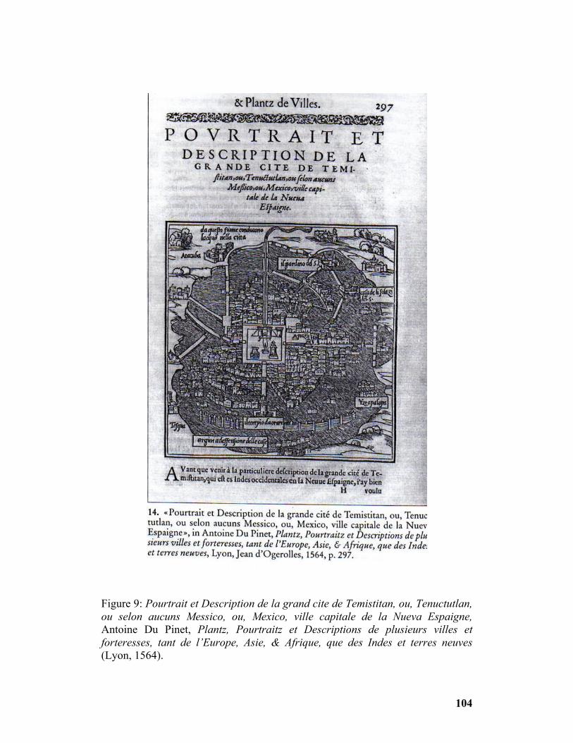
Figure 9: Pourtrait et Description de la grand cite de Temistitan, ou, Tenuctutlan, ou selon aucuns Messico, ou, Mexico, ville capitale de la Nueva Espaigne, Antoine Du Pinet, Plantz, Pourtraitz et Descriptions de plusieurs villes et forteresses, tant de l’Europe, Asie, & Afrique, que des Indes et terres neuves (Lyon, 1564).
104

Figure 10: Mexico, Georg Braun, Civitates orbis terrarum (Cologne, 1572).
105

Bibliography
Abeydeera, A. "Encore Taprobane. Giovanni Battista Ramusio Y Voit Sumatra Et Immanuel Kant Madagascar.” Archipel 56 (1998): 199-230. Agnew, John A., and James S. Duncan. The Power of Place: Bringing Together Geographical and Sociological Imaginations. Boston: Unwin Hyman, 1989. Akerman, James Richard. "On the Shoulders of a Titan: Viewing the World of the Past in Atlas Structure." Ph.D. diss., The Pennsylvania State University, 1991. Albertan-Coppola, S, and M. C. Gomez-Guerard. "La Collection Des Navigationi Et Viaggi (1550-1559) De Giovanni-Battista Ramusio: Mecanismes Et Projets D'apres Les Para-Textes." Revue des Etudes Italiennes 36, no. 1-4 (1990): 59-70. Alberti, Leon Battista. On the Art of Building in Ten Books. Cambridge, MA: MIT Press, 1988. Almagia, Roberto. "Intorno Alle Carte E Figurazioni Annesse All' Isolario Di Benedetto Bordone." Maso Finiguerra 2 (1937): 170-86. Alpers, Svetlana. The Art of Describing: Dutch Art in the Seventeenth Century. Chicago: University of Chicago Press, 1983. Arias, Santa, and Mariselle Melendez. Mapping Colonial Spanish America: Places and Commonplaces of Identity, Culture, and Experience. Lewisburg, PA: Bucknell University Press; London: Associated University Presses, 2002. Armstrong, Lilian. "Benedetto Bordon, ‘Miniator’ and Cartography in Early Sixteenth-Century Venice." Imago Mundi 48 (1996): 65-92. Bonfait, Olivier, ed., et al. Curiosité: Etudes d’Histoire de l’Art en l’Honneur d’Antoine Schapper. Paris: Flammarion, 1998. Bordone, Benedetto, Libro ... De Tutte L'Isole Del Mondo, Venice, 1528. Edited by R.A. Skelton. Amsterdam: Theatrum Orbis Terrarum Ltd., 1966. Boruchoff, David A. "Beyond Utopia and Paradise: Cortés, Bernal Diaz and the Rhetoric of Consecration." MLN 106, no. 2 (1991): 330-69. Bouwsma, William James. Venice and the Defense of Republican Liberty: Renaissance Values in the Age of the Counter Reformation. Berkeley: University of California Press, 1968.
106
Brown, Patricia Fortini. Venice & Antiquity: The Venetian Sense of the Past. New Haven: Yale University Press, 1996. ______Art and Life in Renaissance Venice. New York: Harry N. Abrams, Inc., 1997. Campbell, Mary B. Wonder & Science: Imagining Worlds in Early Modern Europe. Ithaca, NY; London: Cornell University Press, 1999. Carboni, Stefano, Venice and the Islamic World, 828-1797. Translated by Deke Dusinberre. New York: The Metropolitan Museum of Art; New Haven, CT; London: Yale University Press, 2007. Castillo, Susan P. Colonial Encounters in New World Writing, 1500-1786: Performing America. London; New York: Routledge, 2006. Certeau, Michel de. The Practice of Everyday Life. Translated by Steven Rendall. Berkeley: University of California Press, 1984. Cervantes, Fernando. The Devil in the New World: The Impact of Diabolism in New Spain. New Haven; London: Yale University Press, 1994. Chambers, David, Jennifer Fletcher, and Brian S. Pullan. Venice: A Documentary History, 1450-1630. Toronto: University of Toronto Press/Renaissance Society of America, 2001. Chartier, Roger, ed. The Culture of Print: Power and the Uses of Print in Early Modern Europe. Translated by Lydia G. Cochrane. Princeton, NJ: Princeton University Press, 1989 ______The Order of Books: Readers, Authors and Libraries in Europe between the Fourteenth and Eighteenth Centuries. Cambridge: Polity Press, 1994. Ciriacono, Salvatore. Building on Water: Venice, Holland, and the Construction of the European Landscape in Early Modern Times. New York: Berghahn Books, 2006. Concina, Ennio. A History of Venetian Architecture. Cambridge; New York: Cambridge University Press, 1998. Conley, Tom. The Self-Made Map: Cartographic Writing in Early Modern France. Minneapolis, MN; London: University of Minnesota Press, 1996. ______"Virtual Reality and the Isolario." Annali d'Italianistica 14 (1996): 121-30.
107

Conrad, Elsa Ruth. "New World, New Writing?: The Rhetoric of Novelty in French Renaissance Travel Narrative." Ph. D. diss., University of Virginia, 1996. Cormack, Lesley B. Charting an Empire: Geography at the English Universities, 1580-1620. Chicago: University of Chicago Press, 1997. Cortés, Hernan. Letters from Mexico. Translated and Edited by Anthony Pagden. New York: Grossman Publishers, 1971. Cosgrove, Denis E. Social Formation and Symbolic Landscape. Sydney: Croom Helm, 1984 ______ "Mapping New Worlds: Culture and Cartography in Sixteenth-Century Venice." Imago Mundi 44 (1992): 65-89. ______The Palladian Landscape: Geographical Change and Its Cultural Representations in Sixteenth-Century Italy. University Park, PA: Penn State University Press, 1993. ______ ed. Mappings. London: Reaktion Books, 1999. ______Apollo's Eye: A Cartographic Genealogy of the Earth in the Western Imagination. Baltimore: Santa Fe, N.M.: Johns Hopkins University Press/Center for American Places, 2001. Cosgrove, Denis E., and Geoffrey E. Petts, eds. Water, Engineering, and Landscape: Water Control and Landscape Transformation in the Modern Period. London: New York, 1990. Cozzi, Gaetano. Ambiente Veneziano, Ambiente Veneto. Saggi su politica, società, cultura nella Repubblica di Venezia in età moderna. Venice: Marsilio, 2002. Crouzet-Pavan, Elisabeth. "Venice and Torcello: History and Oblivion." Renaissance Studies 8, no. 4 (1994): 416-27. Cummins, Thomas. Toasts with the Inca: Andean Abstraction and Colonial Images on Quero Vessels. Ann Arbor: The University of Michigan Press, 2002. Daston, Lorraine, and Katharine Park. Wonders and the Order of Nature, 1150-1750. New York: Cambridge, MA: Zone Books/MIT Press, 1998. Deleuze, Gilles, and Felix Guattari. A Thousand Plateaus: Capitalism and Schizophrenia. Minneapolis, MN: University of Minnesota Press, 1987. Desan, Philippe. Humanism in Crisis: The Decline of the French Renaissance. Ann Arbor: University of Michigan Press, 1991.
108

Donattini, Massimo. "Giovanni Battista Ramusio e le sue Navigationi. Appunta per una biografia." Critica Storica 17, no. 1 (1980): 56-100. ______Spazio E Modernita: Libri, Carte, Isolari nell'età Delle Scoperte. Bologna: CLUEB, 2000. Eaton, Ruth. Ideal Cities: Utopianism and the (Un)Built Environment. London: Thames & Hudson, 2002. Edgerton, Samuel Y. “Florentine Interests in Ptolemaic Cartography as Background for Renaissance Painting, Architecture, and the Discovery of America.” The Journal of the Society of Architectural Historians 33, no. 4 (December 1974): 275-292. Elliott, John Huxtable. Empires of the Atlantic World: Britain and Spain in America, 1492-1830. New Haven: Yale University Press, 2006. Elsner, Jas, and Joan Pau Rubies. Voyages and Visions: Towards a Cultural History of Travel, Critical Views. London: Reaktion Books, 1999. Farago, Claire J. Reframing the Renaissance: Visual Culture in Europe and Latin America, 1450-1650. New Haven: Yale University Press, 1995. Foucault, Michel. The Order of Things: An Archaeology of the Human Sciences. London: Tavistock Publications, 1974. Fracastoro, Girolamo. Lettera Di Girolamo Fracastoro Sulle Lagune Di Venezia, Ora Per La Prima Volta Pubblicata Ed Illustrata. Venice: Tipografia di Alvisopoli, 1815. Gillis, John R. Islands of the Mind: How the Human Imagination Created the Atlantic World. New York: Palgrave Macmillan, 2004. Gleason, Elisabeth G. Gasparo Contarini: Venice, Rome, and Reform. Berkeley: University of California Press, 1993. Goy, Richard J. Building Renaissance Venice: Patrons, Architects and Builders, 1430-1500. New Haven: Yale University Press, 2006. Greenblatt, Stephen. Marvelous Possessions: The Wonder of the New World. Chicago: University of Chicago Press, 1991. Grosz, E. A. Architecture from the Outside: Essays on Virtual and Real Space. Cambridge, MA: MIT Press, 2001.
109

Harley, J. B. "Silences and Secrecy: The Hidden Agenda of Cartography in Early Modern Europe." Imago Mundi 40 (1988): 57-76. ______"Rereading the Maps of the Columbian Encounter." Annals of the Association of American Geographers 82, no. 3 (1992): 522-36. Harley, J. B. and David Woodward. The History of Cartography. Vol. I. Cartography in Prehistoric, Ancient, and Medieval Europe and the Mediterranean. Chicago: University of Chicago Press, 1987. Harvey, David. The Condition of Postmodernity: An Enquiry into the Origins of Cultural Change. Oxford, England; Cambridge, MA: Blackwell, 1989. ______ Spaces of Hope. Berkeley: University of California Press, 2000. Headley, John M. "The Sixteenth-Century Venetian Celebration of the Earth's Total Habitability: The Issue of the Fully Habitable World for Renaissance Europe." Journal of World History 8, no. 1 (1997): 1-27. Helgerson, Richard. Forms of Nationhood: The Elizabethan Writing of England. Chicago: University of Chicago Press, 1992. Howard, Deborah. "Venice as a Dolphin: Further Investigations into Jacopo De' Barbari's View." Artibus et Historiae 18, no. 35 (1997): 101-11. ______ Venice & the East: The Impact of the Islamic World on Venetian Architecture, 1100-1500. New Haven: Yale University Press, 2000. Hulme, Peter, and William H. Sherman. 'The Tempest' and Its Travels. Philadelphia: University of Pennsylvania Press, 2000. Jacob, Christian. The Sovereign Map: Theoretical Approaches in Cartography throughout History. Translated by Tom Conley and edited by Edward H. Dahl. Chicago: University of Chicago Press, 2006. Johnson, Eugene J. "Jacopo Sansovino, Giacomo Torelli, and the Theatricality of the Piazzetta in Venice." The Journal of the Society of Architectural Historians 59, no. 4 (2000): 436-53. Kagan, Richard L. Spanish Cities of the Golden Age: The Views of Anton Van Den Wyngaerde. Berkeley: University of California Press, 1989. Kagan, Richard L., and Fernando Marias. Urban Images of the Hispanic World, 1493-1793. New Haven: Yale University Press, 2000.
110

Karrow, Robert W. Mapmakers of the Sixteenth Century and Their Maps: Bio-Bibliographies of the Cartographers of Abraham Ortelius, 1570. Chicago: Published for The Newberry Library by Speculum Orbis Press, 1993. Kastan, David Scott, and Peter Stallybrass, eds. Staging the Renaissance: Reinterpretations of Elizabethan and Jacobean Drama. New York: Routledge, 1991. Kemp, Martin. Seen/Unseen: Art, Science, and Intuition from Leonardo to the Hubble Telescope. Oxford; New York: Oxford University Press, 2006. Kendrick, Christopher. Utopia, Carnival, and Commonwealth in Renaissance England. Toronto: University of Toronto Press, 2004. Kim, David Y. "Uneasy Reflections: Images of Venice and Tenochtitlan in Benedetto Bordone's Isolario." Res 49-50 (2006): 81-91. Kumar, Krishan, and Stephen Bann, eds. Utopias and the Millennium. London: Reaktion Books, 1993. Kupperman, Karen Ordahl, ed. America in European Consciousness, 1493-1750. Williamsburg, VA: The University of North Carolina Press, 1995. Landau, David, and Peter W. Parshall. The Renaissance Print: 1470-1550. New Haven: Yale University Press, 1994. Latour, Bruno, and Peter Weibel, eds. Making Things Public: Atmospheres of Democracy. Cambridge, MA: MIT Press; Karlsruhe, Germany: ZKM/Center for Art and Media, 2005. Leslie, Marina. Renaissance Utopias and the Problem of History. Ithaca, NY; London: Cornell University Press, 1998. Lestringant, Frank. "Fortunes De La Singularité à La Renaissance: Le Genre De L' ‘Isolario.’" Studi Francesi 28, no. 3 (1984): 415-36. ______ Mapping the Renaissance World: The Geographical Imagination in the Age of Discovery. Berkeley: University of California Press, 1994. ______ Le Livre Des Iles: Atlas et Récits Insulaires de la Genèse à Jules Verne. Geneva: Librairie Droz, 2002. Levenson, Jay A., ed. Circa 1492: Art in the Age of Exploration. New Haven: Yale University Press; Washington: National Gallery of Art, 1991.
111

MacLean, Gerald M. Re-Orienting the Renaissance: Cultural Exchanges with the East. Basingstoke, England; New York: Palgrave Macmillan, 2005 . Manners, I. R. "Constructing the Image of a City: The Representation of Constantinople in Christopher Buondelmonti's Liber Insularum Archipelagi." Annals of the Association of American Geographers 87, no. 1 (1997): 72-102. Manuel, Frank Edward, and Fritzie Prigohzy Manuel. Utopian Thought in the Western World. Cambridge, MA: Belknap Press, 1979. Marin, Louis. Utopics: The Semiological Play of Textual Spaces. Translated by Robert A. Vollrath. Atlantic Highlands, NJ: Humanities Press International, 1990. ______On Representation. Translated by Catherine Porter. Stanford, CA: Stanford University Press, 2001. Martin, John Jeffries, and Dennis Romano. Venice Reconsidered: The History and Civilization of an Italian City-State, 1297-1797. Baltimore: Johns Hopkins University Press, 2000. Mignolo, Walter. The Darker Side of the Renaissance: Literacy, Territoriality, and Colonization. Ann Arbor: University of Michigan Press, 1995. Milanesi, M. "Nuovo Mondo E Terra Incognita in Margine Alla Mostra.” Rivista Geografica Italiana 90, no. 1 (1983): 81-92. Molho, Anthony, Kurt A. Raaflaub, and Julia Emlen, eds. City-States in Classical Antiquity and Medieval Italy. Ann Arbor: University of Michigan Press, 1991. Muir, Edward. Civic Ritual in Renaissance Venice. Princeton, NJ: Princeton University Press, 1981. Mundy, Barbara E. The Mapping of New Spain: Indigenous Cartography and the Maps of the Relaciones Geograficas. Chicago: University of Chicago Press, 1996. ______"Mapping the Aztec Capital: The 1524 Nuremberg Map of Tenochtitlan, Its Sources and Meanings." Imago Mundi 50 (1998): 11-33. Nora, Pierre. "Between Memory and History: Les Lieux De Memoire." Representations 26 (Spring 1989): 7-24. Nuti, Lucia. "The Perspective Plan in the Sixteenth Century: The Invention of a Representational Language." The Art Bulletin 76, no. 1 (1994): 105-28. Padrón, Ricardo. The Spacious Word: Cartography, Literature, and Empire in Early Modern Spain. Chicago: University of Chicago Press, 2004.
112
Pagden, Anthony. The Fall of Natural Man: The American Indian and the Origins of Comparative Ethnology. Cambridge; New York: Cambridge University Press, 1986. ______European Encounters with the New World: From Renaissance to Romanticism. New Haven: Yale University Press, 1993. Parks, George Bruner. "Ramusio's Literary History." Studies in Philology 52 (1955): 127-48. ______The Contents and Sources of Ramusio's ‘Navigationi.’ New York: New York Public Library, 1955. Pullan, Brian, ed. Crisis and Change in the Venetian Economy in the Sixteenth and Seventeenth Centuries. London: Methuen, 1968. Rabasa, Jose. Inventing America: Spanish Historiography and the Formation of Eurocentrism. Norman: University of Oklahoma Press, 1993. Ramusio, Giovanni Battista. Navigationi Et Viaggi: Venice, 1563-1606. Edited with an introduction by R.A. Skelton. Amsterdam: Theatrum Orbis Terrarum, 1967. ______Navigazioni e Viaggi, 6 vols. Edited with an introduction by Marica Milanesi. Turin: Einaudi, 1978. Rubies, Joan-Pau. "Travel Writing as Genre: Facts, Fiction and the Invention of a Scientific Discourse in Early Modern Europe." Journeys 1, no. 1-2 (2000): 5-35. Sartor, Mario. La Citta E La Conquista: Mappe E Documenti Sulla Trasformazione Urbana E Territoriale Nell'america Centrale Del 500. Reggio Calabria: Casa del Libro, 1981. Saville, Marshall H. Narrative of Some Things of New Spain and of the Great City of Temestitan Mexico. New York: Cortes Society, 1917. Schaer, Roland, Gregory Claeys, and Lyman Tower Sargent, eds. Utopia: The Search for the Ideal Society in the Western World. New York: The New York Public Library/Oxford University Press, 2000. Schulz, Juergen. The Printed Plans and Panoramic Views of Venice (1486-1797). Saggi E Memorie Di Storia Dell'arte, 7. Florence: L.S. Olschki, 1970.
113

114
______"Jacopo De' Barbari's View of Venice: Map Making, City Views, and Moralized Geography before the Year 1500." The Art Bulletin 60, no. 3 (1978): 425-74. ______La Cartografia Tra Scienza E Arte: Carte E Cartografi Nel Rinascimento Italiano. Modena: F.C. Panini, 1990. Schwartz, Stuart B, ed. Implicit Understanding, Observing, Reporting, and Reflecting on the Encounters between Europeans and Other Peoples in the Early Modern Era. Cambridge; New York: Cambridge University Press, 1994. Smith, Pamela H., and Paula Findlen, eds. Merchants & Marvels: Commerce, Science and Art in Early Modern Europe, Merchants and Marvels. New York: Routledge, 2002. Tafuri, Manfredo. Venice and the Renaissance. Cambridge, MA: MIT Press, 1989. Toussaint, Manuel, Federico Gomez de Orozco, and Justino Fernandez. Planos De La Ciudad De Mexico: Siglos XVI y XVII, Estudio Historico, Urbanistico y Bibliografico. Mexico: In association with ‘Cvltvra,’ 1938. Tracy, James D, ed. City Walls: The Urban Enceinte in Global Perspective. New York: Cambridge University Press, 2000. Turner, Hilary Louise. "Christopher Buondelmonti and the Isolario." Terrae Incognitae, The Journal for the History of Discoveries 19 (1987): 11-28. Wilson, Bronwen. The World in Venice: Print, the City, and Early Modern Identity. Toronto; Buffalo: University of Toronto Press, 2005. Woodward, David, ed. Art and Cartography: Six Historical Essays. Chicago: University of Chicago Press, 1987. ______Maps as Prints in the Italian Renaissance: Makers, Distributors & Consumers. London: British Library, 1996.