A Tour Guide for CyclistsBike Shop 20’ elevation contour Municipal border County border Parks &...
4
A GORGEOUS RIDE: THE COLUMBIA TRAIL New Jersey Department of Transportation THINGS TO DO/ATTRACTIONS BOROUGH OF HIGH BRIDGE is a quaint, small town with shops, restaurants, and many historical buildings, including the Taylor-Wharton Iron and Steel Company (TISCO) complex. e 28.3 acre TISCO Complex was once part of the Union Iron Works founded in 1742. e Iron Works produced tools and cannon balls for Washington’s Army during the Revolutionary War. e Taylor- Wharton Iron and Steel Company was the nation’s oldest continuously operating foundry in the country, and America’s second oldest business. e property is now part of the borough’s permanent open space. KEN LOCKWOOD GORGE WILDLIFE MANAGEMENT AREA (WMA) has been identified as one of the “Ten Most Beautiful Places in New Jersey” by New Jersey Monthly Magazine. Its steep slopes, huge boulders, impressive rapids and northern hemlocks, have made the Gorge an attractive site to birders, naturalists, kayakers, photographers, hikers, fishermen and outdoor enthusiasts. www.njfishandwildlife.org/wmas.htm THE SOLITUDE PROPERTY consists of the Solitude House, Lake Solitude, and Waterfall. Considered one of the most picturesque locations in High Bridge, the property is now used for canoeing, fishing, a museum and bird watching. Built for the manager of Union Forge, Solitude House served as a prison for John Penn, the last colonial governor of Pennsylvania, during the Revolutionary War. BOROUGH OF CALIFON is a Victorian-style enclave where the houses are marked with the names of the builders and their dates of establishment rather than with street numbers. e Califon Historical Society has registered 170 structures with the National Register of Historic Places. www.califonborough-nj.org VILLAGE OF LONG VALLEY is an unincorporated community located within and a part of Washington Township. e village includes a cluster of businesses, dwellings and restaurants nestled near the foot of Schooley’s Mountain near the intersection of County Routes 513 and 517. http://lvva.org WILLOW GROVE FARM is home to a herd of over 30 Clydesdale Horses. Located in the Middle Valley section of Long Valley, it is one of the largest breeding and training facilities of Clydesdales in the East. e farm is host to a variety of events and activities, including guided trail rides. www.willowgrovefarm.org A Tour Guide for Cyclists e Columbia Trail is a multi-use path that runs for 15 miles from High Bridge in Hunterdon County to the border of Mt. Olive and Washington Township in Morris County. Built upon an abandoned railroad corridor, the trail is named for the Columbia Gas Line constructed under the former rail bed in the 1990’s. Typical of rail trails, the route is relatively flat as it parallels the meandering South Branch of the Raritan River. Developed and maintained by the Hunterdon and Morris County Parks Departments, the trail surface is mostly crushed stone with short segments of larger gravel or dirt. Bicycles with wider tires are recommended. ere are several options suggested for enjoying the trail and vicinity. In addition to the trail with its bucolic setting and spectacular views, two on-road alternatives are presented. e southern on-road alternative diverges from the trail at Califon. It hugs the South Branch of the Raritan River through Ken Lockwood Gorge on a one lane road that is closed to motor vehicle traffic. is on-road segment connects to the trail at its southern terminus in High Bridge. e northern on-road alternative deviates from the trail at Long Valley and reconnects with the trail to the south at Middle Valley Road. is option is hilly and challenging.
Transcript of A Tour Guide for CyclistsBike Shop 20’ elevation contour Municipal border County border Parks &...
A GorGeous ride: The ColumbiA TrAil
New JerseyDepartment ofTransportation
THINGS TO DO/ATTRACTIONS
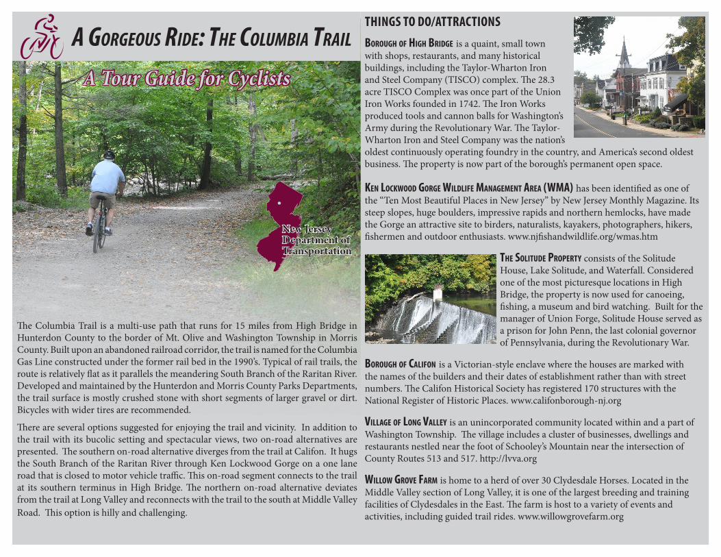
Borough of high Bridge is a quaint, small town with shops, restaurants, and many historical buildings, including the Taylor-Wharton Iron and Steel Company (TISCO) complex. The 28.3 acre TISCO Complex was once part of the Union Iron Works founded in 1742. The Iron Works produced tools and cannon balls for Washington’s Army during the Revolutionary War. The Taylor-Wharton Iron and Steel Company was the nation’s oldest continuously operating foundry in the country, and America’s second oldest business. The property is now part of the borough’s permanent open space.
Ken LocKwood gorge wiLdLife ManageMent area (wMa) has been identified as one of the “Ten Most Beautiful Places in New Jersey” by New Jersey Monthly Magazine. Its steep slopes, huge boulders, impressive rapids and northern hemlocks, have made the Gorge an attractive site to birders, naturalists, kayakers, photographers, hikers, fishermen and outdoor enthusiasts. www.njfishandwildlife.org/wmas.htm
the SoLitude ProPerty consists of the Solitude House, Lake Solitude, and Waterfall. Considered one of the most picturesque locations in High Bridge, the property is now used for canoeing, fishing, a museum and bird watching. Built for the manager of Union Forge, Solitude House served as a prison for John Penn, the last colonial governor of Pennsylvania, during the Revolutionary War.
Borough of caLifon is a Victorian-style enclave where the houses are marked with the names of the builders and their dates of establishment rather than with street numbers. The Califon Historical Society has registered 170 structures with the National Register of Historic Places. www.califonborough-nj.org
ViLLage of Long VaLLey is an unincorporated community located within and a part of Washington Township. The village includes a cluster of businesses, dwellings and restaurants nestled near the foot of Schooley’s Mountain near the intersection of County Routes 513 and 517. http://lvva.org
wiLLow groVe farM is home to a herd of over 30 Clydesdale Horses. Located in the Middle Valley section of Long Valley, it is one of the largest breeding and training facilities of Clydesdales in the East. The farm is host to a variety of events and activities, including guided trail rides. www.willowgrovefarm.org
A Tour Guide for Cyclists
The Columbia Trail is a multi-use path that runs for 15 miles from High Bridge in Hunterdon County to the border of Mt. Olive and Washington Township in Morris County. Built upon an abandoned railroad corridor, the trail is named for the Columbia Gas Line constructed under the former rail bed in the 1990’s. Typical of rail trails, the route is relatively flat as it parallels the meandering South Branch of the Raritan River. Developed and maintained by the Hunterdon and Morris County Parks Departments, the trail surface is mostly crushed stone with short segments of larger gravel or dirt. Bicycles with wider tires are recommended.
There are several options suggested for enjoying the trail and vicinity. In addition to the trail with its bucolic setting and spectacular views, two on-road alternatives are presented. The southern on-road alternative diverges from the trail at Califon. It hugs the South Branch of the Raritan River through Ken Lockwood Gorge on a one lane road that is closed to motor vehicle traffic. This on-road segment connects to the trail at its southern terminus in High Bridge. The northern on-road alternative deviates from the trail at Long Valley and reconnects with the trail to the south at Middle Valley Road. This option is hilly and challenging.

OCEAN
SUSSEX
ATLANTIC
BURLINGTON
MORRIS
SALEM
MONMOUTH
CUMBERLAND
ESSEXWARREN
HUNTERDON
BERGEN
SOMERSET
MIDDLESEX
CAPE MAY
MERCER
GLOUCESTER CAMDEN
PASSAIC
UNIONHUDSON
HUNTERDON COUNTY
MORRIS
WARRENCOUNTY
COUNTY
HIGH BRIDGE
CALIFON
LONG VALLEY
32
1
BARTLEY ROAD
DIRECTIONS
DATA SOURCESRoads, New Jersey Dept. of
Transportation; Parks & Open Space and Elevation Contours, New Jersey Dept. of Environmental Protection;
Preserved Farmland; New Jersey Dept. of Agriculture
coLuMBia traiL
High Bridge to Califon
Califon to Long Valley
Long Valley to Bartley Road
on-road aLternatiVeS
Southern On-Road Alternative
Northern On-Road Alternative
Mile Marker
Parking
Bike Shop
20’ elevation contour
Municipal border
County border
Parks & Open Space
Preserved Farmland
The 15.1 mile trail can be divided into 3 segments that roughly correspond to the map panels shown on the Location Map to the right (Map 1 - High Bridge to Califon; Map 2 - Califon to Long Valley; and Map 3 - Long Valley to Bartley Road). Two on-road alternatives are also provided. Directions for the trail are from the south to the north and from the north to the south for the on-road alternatives in order to create a loop ride.
High Bridge to Califon (5.25 mi.) Mileage Route Directions (south to north)0.0 Trail begins at Commons Park (79 Main Street).
Exit park; cross Main Street.2.7 Go across the High Bridge over the South
Branch of the Raritan River.3.65 Trail crosses Hoffmans Crossing Road. Cross
with caution. 4.10 Trail crosses Bloeser Lane. Yield to traffic.5.15 Pass the Califon Railroad Station.
Cross Academy Street. 5.25 Arrive at Main Street. Services and restuarants
along Main Street. To return to High Bridge via the Southern On-Road Alternative, turn left (west) on Main Street toward River Road.
Califon to Long Valley (6 mi.)Mileage Route Directions (south to north)
5.25 Cross Main Street. Trail parallels Bank Street. 6.4 Trail surface changes to dirt and closely parallels
Vernoy Road. Many choose to ride the paved road.
6.6 Trail turns away from Vernoy Road and surface returns to crushed stone.
7.0 Trail crosses West Valley Brook Road and enters Morris County.
7.5 Trail crosses CR 513/West Mill Road.8.5 Trail crosses Middle Valley Road. End of the
Northern On-Road Alternative.11.25 Reach CR 517/Schooley’s Mountain Road.
Arrive in Long Valley. Begining of the Northern On-Road Alternative.
Long Valley to Bartley Road (3.85 mi.) Mileage Route Directions (south to north)11.25 Cross CR 517/Schooley’s Mountain Road.11.35 Cross Fairview Avenue.11.75 After passing “Enclave at Long Valley” housing development,
stay left and follow dirt path to continue on trail. 13.3 Cross Naughright Road.13.9 Cross Elizabeth Lane (private drive).14.2 Cross Four Bridges Road.14.85 Cross driveway to parking area.15.1 Trail ends at CR 625/Bartley Road.
Southern On-Road Alternative (6.4 miles)Mile-age
Pt. to Pt.
Route Directions (north to south)
0.0 0.0 At the intersection of the Columbia Trail and Main Street, head west toward Bank Street.
0.1 0.1 Before the bridge, turn left onto River Road. 2.1 2.0 River Road closed to motor vehicle traffic. Surface
changes to gravel.3.7 1.6 River Road open to motor vehicle traffic. Surface
changes to asphalt.4.3 4.2 Turn left onto Cokesbury Road.4.3 200 ft Right at stop sign onto CR 639/River Road. 5.5 1.2 After passing Herman Thau Road, name changes to Wash-
ington Avenue. Keep right to stay on Washington Avenue.6.2 0.7 Turn left onto McDonald Street.6.3 425 ft Right at stop sign onto Main Street.6.4 0.1 Arrive at Commons Park (79 Main Street).
Northern On-Road Alternative (4.6 miles)Hilly and challenging.Mile-age
Pt. to Pt.
Route Directions (north to south)
0.0 0.0 From the Columbia Trail, head north on Schooley’s Mountain Road. Steep climb.
1.4 1.4 Turn left at the traffic signal onto West Springtown Road.1.9 0.5 Keep left at the fork to stay on West Springtown Road. 3.4 1.5 Left at stop sign onto Zellers Road. Steep descent. 4.1 0.7 Left at stop sign onto Middle Valley Road. Steep descent.4.6 0.5 Arrive at the Columbia Trail.
ÄÄ Ä ÄÄ Ä
% % % % % %
" " " " " "
LOCATION MAP
0 0.5 1 mile
LEGEND% % %
ÄÄ Ä Ä
" " "1Map 1Map 1
Map 2
Map 3
Map 1
Maps 2 & 3

Æb
See Map 2
%%
%%
KL513
KL639
KL512
KL628
KL513
KL639
Lebanon Township
Clinton Township
Califon Borough
Tewksbury Township
High Bridge Borough
COMMONS PARK
KEN LOCKWOODGORGEWMA
VORHEESSTATE PARK
MCDONALD
STREET
MAIN STREET WAS H IN
GTO
N AVE
N UE
COKESBURY ROAD
COKES
BURY RO A D
VOORHEES ROAD
STEVENSON LANE
OLD READINGSBURG R
OAD
COKES BURY CALIFON R
OAD
HICKORY RUN ROA D
HIGH BRIDGE CALIFON ROAD
HIGH B
RIDG
E CAL
IFON R
O AD
RIVER ROAD
RIVER
ROA
D
HOFFMANS CRO
S
S ING ROAD
BLOESER LANE
LAKE
SOLIT
UDE
TISCO AVENUE
RIVER RO AD
MAIN STREET
RIVER
ROAD
MAIN STREETACA D E M Y STREET
WILSON AVENUE
NASSAU ROAD
HERMAN THAU ROAD
1MI
2MI
3MI
4MI
5MI
FMAP 1START OF SOUTHERN
ON-ROAD ALTERNATIVE
TRAIL DIRECTIONS BEGIN / END OF SOUTHERN
ON-ROAD ALTERNATIVE
See Map 3
See Map 1
%%
%%
%%
%%
%%
%%
%%
%%
%%
%
%%
%%
%%
%%
%%
%%
%%
%%
%%
%%
%%
%%
%
%%
%%
%%
%%
%%
%%
%%
KL513
KL512
KL513
KL513Washington
Township
Lebanon Township Tewksbury
Township
Califon Borough
VERN
OY RO
AD
SLIKER ROAD
TURT
LEBA
CK ROA
D
FROG H
OLLO
W RO
AD
WEST S
PRING
TOWN R
OAD
BEACON HILL ROAD
TRIMMER ROAD
WES
T MILL
ROAD
M IDDLE VAL
LEY ROAD
WES
T MILL
ROAD
BANK
STRE
ET
MAIN STREET
RIVER
RO
AD
HIGH B
RIDGE
- CAL
IFON R
OAD
HIGH
BRID
GE-C
ALIFO
N ROA
D
RAILR
OAD A
VENUE
VE RNOY ROAD WEST VALLEY B ROOK ROAD
A
C A D EMY ST REET
MAIN STREET
ZELLER S ROADHIGH MEAD
OW LA
NE
MA
RKHAM DRIVE
5MI
6MI
7MI
8MI
9MI
10MI
WILLOWGROVE
FARM
FMAP 2
END OF NORTHERN ON-ROAD ALTERNATIVE
See Map 2
%%
%%
%%
%%
%%
%%
%%
%%
KL513
KL625
KL517KL517
KL625
Washington Township
Mount Olive Township
Chester Township
SCHOOLEY’S MOUNTAIN COUNTY PARK
SCHOOLEY’S MOUNTAIN
COUNTY PARK
PALMER PARK
NAUGHRIGHT ROAD
RICE LANE
ROCK ROAD
COLEMAN ROAD
ELIZABETH LANE
EAST MAPLE AVENUE
FAIRV
IEW
AVEN
UE
BARTLEY ROAD
CAMP WASHINGTON ROA D
SCHOOLEY’S M OUNT
AIN R
OAD
JAMES
TRAIL
WEHRL
I ROAD
FAIRMOUNT ROAD
EAST SPRINGTOWN ROAD
FOUR BRIDGES ROAD
FOUR
BRIDGES ROAD
EAST M
ILL ROA
D
WES
T MILL
ROAD
FAIRVI E W AV ENUE
NAU G HRIG
HT ROAD
H ARVEST LANE
WEST SPRINGTOW
N ROAD
FAIRVIEW AVENUE
11MI
12MI
13MI
15MI
14MI
FMAP 3
START OF NORTHERN ON-ROAD ALTERNATIVE
coLuMBia traiL
High Bridge to Califon
Califon to Long Valley
Long Valley to Bartley Road
on-road aLternatiVeS
Southern On-Road Alternative
Northern On-Road Alternative
0.0mi
1.0mi
2.0mi
3.0mi
4.0mi
5.0mi
5.0mi
6.0mi
7.0mi
8.0mi
9.0mi
10mi
11mi
12mi
13mi
14mi
15mi

GENERAL TIPSPLan ahead.Read the route directions before beginning the ride. Be aware of traffic patterns. Plan trips to avoid peak traffic times.
oBey Safety LawS.In New Jersey, a bicyclist has the same rights and responsibilities as a motor vehicle driver. Obey all traffic signs and signals. Ride as near to the right of the road as practicable exercising due care when passing; ride in the same direction as vehicular traffic; show your intention clearly when turning and changing lanes.
wear a heLMet.This will reduce the possibility of disabling head injuries in the event of a fall or collision. Anyone under 17 years of age that rides a bicycle or is a passenger on a bicycle, or is towed as a passenger by a bicycle must wear a safety helmet.
Share the road/traiL.Be aware of and respect the rights and safety of other road and trail users, especially children, pedestrians, joggers and equestrians.
Be aware of road conditionS.The NJDOT does not guarantee that the route is completely free from conditions that may be a hazard to bicycle traffic and takes no responsibility for the safety and fitness of the user and suggested route. In preparing this route, every attempt has been made to select roads that can provide a quality bicycling experience. However, road conditions continually change: pavements deteriorate, roads are resurfaced, more development leads to increased traffic. Conditions listed in this route were effective at publishing. Construction notices and traffic advisories can be found on www.511nj.org
read the new JerSey BicycLing ManuaL.Riding a bicycle requires you to be responsible for your actions, for your safety and for the safety of others. This manual covers: Quick Maintenance Checks, Traffic Basics, Sharing the Road, Parking your Bike, Riding at Night and in Rain and Snow, Riding with Others, and Traffic Signals, Signs and Road Markings. The manual is available online at www.state.nj.us/transportation/commuter/bike/ for More inforMation PLeaSe contact:
Bicycle & Pedestrian Program CoordinatorNew Jersey Department of Transportation
1035 Parkway AvenueP.O. Box 600
Trenton, NJ [email protected]
www.state.nj.us/transportation/commuter/bike/
OTHER MAPS & GUIDEShunterdon county diViSion of ParKS & recreation coLuMBia traiL Brochure and traiL MaPwww.co.hunterdon.nj.us/depts/parks/ParkAreas/ColumbiaTrail/info.htm
MorriS county ParK coMMiSSion coLuMBia traiL MaP & inforMationwww.morrisparks.net/aspparks/columbiamain.asp
new JerSey BicycLe MaP and reSource guidewww.state.nj.us/transportation/commuter/bike/guide.shtm
State of new JerSey, diViSion of traVeL and touriSMwww.visitnj.org
raiLS-to-traiLS conSerVancy’S traiL of the Month: octoBer 2014http://www.railstotrails.org/news/recurringFeatures/trailMonth/archives/1410.html
The State of New Jersey has published this map and brochure to aid the cyclist and takes no responsibility for user’s safety or fitness of the suggested routes. Ride carefully. This map
illustrates the route and should be used for general wayfinding purposes.Map by The RBA Group