A study on Planning of Rural Settlement: A Case Study of ...
30
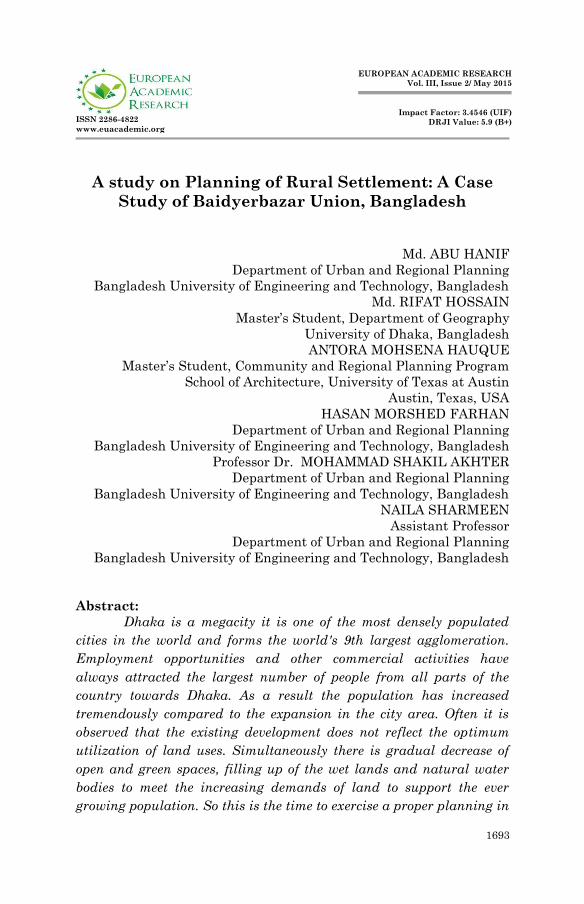
1693 ISSN 2286-4822 www.euacademic.org EUROPEAN ACADEMIC RESEARCH Vol. III, Issue 2/ May 2015 Impact Factor: 3.4546 (UIF) DRJI Value: 5.9 (B+) A study on Planning of Rural Settlement: A Case Study of Baidyerbazar Union, Bangladesh Md. ABU HANIF Department of Urban and Regional Planning Bangladesh University of Engineering and Technology, Bangladesh Md. RIFAT HOSSAIN Master’s Student, Department of Geography University of Dhaka, Bangladesh ANTORA MOHSENA HAUQUE Master’s Student, Community and Regional Planning Program School of Architecture, University of Texas at Austin Austin, Texas, USA HASAN MORSHED FARHAN Department of Urban and Regional Planning Bangladesh University of Engineering and Technology, Bangladesh Professor Dr. MOHAMMAD SHAKIL AKHTER Department of Urban and Regional Planning Bangladesh University of Engineering and Technology, Bangladesh NAILA SHARMEEN Assistant Professor Department of Urban and Regional Planning Bangladesh University of Engineering and Technology, Bangladesh Abstract: Dhaka is a megacity it is one of the most densely populated cities in the world and forms the world's 9th largest agglomeration. Employment opportunities and other commercial activities have always attracted the largest number of people from all parts of the country towards Dhaka. As a result the population has increased tremendously compared to the expansion in the city area. Often it is observed that the existing development does not reflect the optimum utilization of land uses. Simultaneously there is gradual decrease of open and green spaces, filling up of the wet lands and natural water bodies to meet the increasing demands of land to support the ever growing population. So this is the time to exercise a proper planning in
Transcript of A study on Planning of Rural Settlement: A Case Study of ...
1693
ISSN 2286-4822
www.euacademic.org
EUROPEAN ACADEMIC RESEARCH
Vol. III, Issue 2/ May 2015
Impact Factor: 3.4546 (UIF)
DRJI Value: 5.9 (B+)
A study on Planning of Rural Settlement: A Case
Study of Baidyerbazar Union, Bangladesh
Md. ABU HANIF
Department of Urban and Regional Planning
Bangladesh University of Engineering and Technology, Bangladesh
Md. RIFAT HOSSAIN
Master’s Student, Department of Geography
University of Dhaka, Bangladesh
ANTORA MOHSENA HAUQUE
Master’s Student, Community and Regional Planning Program
School of Architecture, University of Texas at Austin
Austin, Texas, USA
HASAN MORSHED FARHAN
Department of Urban and Regional Planning
Bangladesh University of Engineering and Technology, Bangladesh
Professor Dr. MOHAMMAD SHAKIL AKHTER
Department of Urban and Regional Planning
Bangladesh University of Engineering and Technology, Bangladesh
NAILA SHARMEEN
Assistant Professor
Department of Urban and Regional Planning
Bangladesh University of Engineering and Technology, Bangladesh
Abstract:
Dhaka is a megacity it is one of the most densely populated
cities in the world and forms the world's 9th largest agglomeration.
Employment opportunities and other commercial activities have
always attracted the largest number of people from all parts of the
country towards Dhaka. As a result the population has increased
tremendously compared to the expansion in the city area. Often it is
observed that the existing development does not reflect the optimum
utilization of land uses. Simultaneously there is gradual decrease of
open and green spaces, filling up of the wet lands and natural water
bodies to meet the increasing demands of land to support the ever
growing population. So this is the time to exercise a proper planning in

Md. Abu Hanif, Md. Rifat Hossain, Antora Mohsena Hauque, Hasan Morshed Farhan,
Mohammad Shakil Akhter, Naila Sharmeen- A study on Planning of Rural
Settlement: A Case Study of Baidyerbazar Union, Bangladesh
EUROPEAN ACADEMIC RESEARCH - Vol. III, Issue 2 / May 2015
1694
rural areas to lessen the growing population pressure on Dhaka.
Baidyerbazar is an agricultural based rural area. This research has
been initiated to formulate a physical planning of Baidyerbazar union
to make it a self-reliant entity for rural development. Baidyerbazar,
being one of the examples of those rural areas where agricultural land
is decreasing, is in grave need for the aid of planning. Therefore, if
proper planning procedures are adopted according to the proposed
plan, then Baidyerbazar union would be a better place for housing and
employment for the people living within this area for a long time in the
future. So rural planning should be implemented immediately to
ensure better life of rural people in Bangladesh.
Key words: Rural Planning, Settlement, Sustainable, Crop
1. Introduction
Dhaka is a megacity and one of the major cities of South Asia.
It is one of the most densely populated cities in the world and
forms the world's 9th largest agglomeration. It has a population
of around 13 million. Today it serves as one of the prime centers
for politics, culture, education, business and economy for the
whole country. Its trends of urban growth can be illustrated in
terms of population growth, land uses, transportation,
agricultural production, land values, activity patterns etc. So it
is facing a thrust for growth. For that reason Dhaka suffers
from urban problems such as pollution, congestion and lack of
housing problems, food crisis and adequate services due to the
rising population. At present it is needed to decentralize the
growth trends of Dhaka to another suitable location. To achieve
this, rural lands must be developed. Baidyerbazar is one of the
most suitable sites for this purpose. It covers a large area with
valuable parcel of land which can be properly utilized.
Md. Abu Hanif, Md. Rifat Hossain, Antora Mohsena Hauque, Hasan Morshed Farhan,
Mohammad Shakil Akhter, Naila Sharmeen- A study on Planning of Rural
Settlement: A Case Study of Baidyerbazar Union, Bangladesh
EUROPEAN ACADEMIC RESEARCH - Vol. III, Issue 2 / May 2015
1695
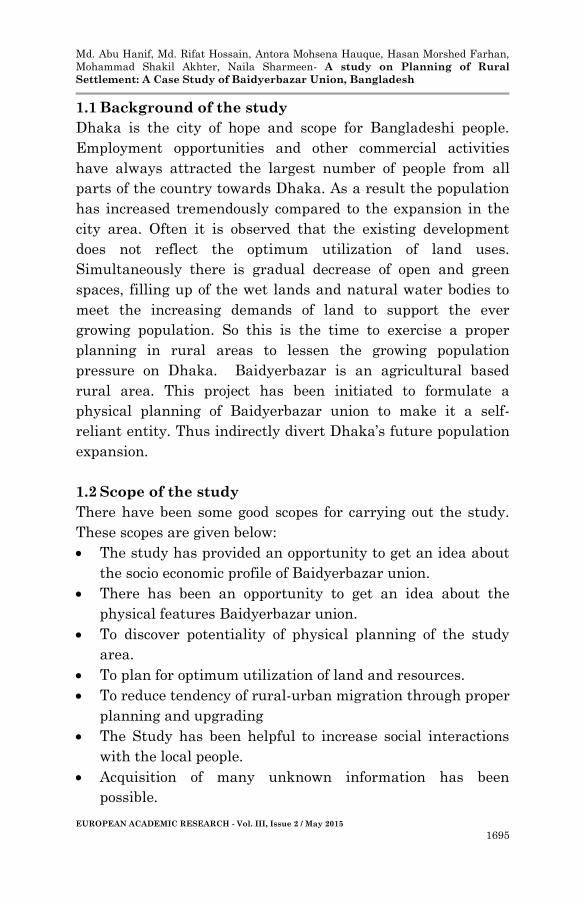
1.1 Background of the study
Dhaka is the city of hope and scope for Bangladeshi people.
Employment opportunities and other commercial activities
have always attracted the largest number of people from all
parts of the country towards Dhaka. As a result the population
has increased tremendously compared to the expansion in the
city area. Often it is observed that the existing development
does not reflect the optimum utilization of land uses.
Simultaneously there is gradual decrease of open and green
spaces, filling up of the wet lands and natural water bodies to
meet the increasing demands of land to support the ever
growing population. So this is the time to exercise a proper
planning in rural areas to lessen the growing population
pressure on Dhaka. Baidyerbazar is an agricultural based
rural area. This project has been initiated to formulate a
physical planning of Baidyerbazar union to make it a self-
reliant entity. Thus indirectly divert Dhaka’s future population
expansion.
1.2 Scope of the study
There have been some good scopes for carrying out the study.
These scopes are given below:
The study has provided an opportunity to get an idea about
the socio economic profile of Baidyerbazar union.
There has been an opportunity to get an idea about the
physical features Baidyerbazar union.
To discover potentiality of physical planning of the study
area.
To plan for optimum utilization of land and resources.
To reduce tendency of rural-urban migration through proper
planning and upgrading
The Study has been helpful to increase social interactions
with the local people.
Acquisition of many unknown information has been
possible.
Md. Abu Hanif, Md. Rifat Hossain, Antora Mohsena Hauque, Hasan Morshed Farhan,
Mohammad Shakil Akhter, Naila Sharmeen- A study on Planning of Rural
Settlement: A Case Study of Baidyerbazar Union, Bangladesh
EUROPEAN ACADEMIC RESEARCH - Vol. III, Issue 2 / May 2015
1696
1.3 Limitation of the study
Due to the requirements and scope of the project there have
been some limitations involved in the study. The limitations are
as follows:
Inadequate manpower: The number of group
members has been four and has been insufficient to
accomplish the study intended for a big area like
Baidyerbazar union.
Time limitation: The study time has been only seven
week which made it tough to study the area
comprehensively.
Sensitive incident: Many families have unsupportive
to the study because the study area has been far away
from the city.
1.4 Methodology
Methodology means the steps followed to execute the study to
achieve some desired objectives. The methodology followed to
complete the study on the physical planning of Baidyerbazar
union is described below:
1.4.1 Collection of Base map:
The base map has been collected from RAJUK. Basic data
formatted in ArcGIS (e.g. shape files, MXD files) has been
collected to identify the study area and to run the study.
1.4.2 Field Survey:
Before collection of necessary primary data, a field survey has
been conducted by all groups. Thus the over-all idea about the
project has been obtained. Information has also been collected
to correct some of missing values of secondary data.
1.4.3 Data collection
Two types of sources were used to collect data. These are
primary data and secondary data.
2
Md. Abu Hanif, Md. Rifat Hossain, Antora Mohsena Hauque, Hasan Morshed Farhan,
Mohammad Shakil Akhter, Naila Sharmeen- A study on Planning of Rural
Settlement: A Case Study of Baidyerbazar Union, Bangladesh
EUROPEAN ACADEMIC RESEARCH - Vol. III, Issue 2 / May 2015
1697
1.4.3.1 Primary data collection: Field Survey is one of the
most vital parts of such kind of study. To achieve the goals of
the study, data has been collected by field survey.
1.4.3.2 Secondary data collection: From ArcGIS formatted
data, necessary data have been collected. Again, for successful
study, relevant documents, such as theses, reports, papers,
books etc have been reviewed.
1.4.4 Data processing and analysis: Collected data have
been analyzed to find out the present land use pattern. Some
data have been compiled for comprehensive analysis. Again
some data have been interpreted for proper planning of the
study area as well.
1.4.5 Preparation of Proposals and Design procedure:
After the data processing and analysis some proposals have
been suggested to make agricultural based development of the
study area. Then a new and improved land use design of the
study area has been prepared.
1.4.6 Presentation: Following the above a power-point
presentation has been made to demonstrate the entire study
and the final design proposals.
1.4.7 Preparation of final report: Finally all the works,
analysis, findings, proposals and designs have been
summarized in the report, with necessary maps, graphs and
tables etc. Thus the report has been prepared.
2. Conceptual Framework
This chapter enlightens about rural areas, its characteristics,
necessity for rural development, rural development
organizations, types of rural settlements, rural sustainability
Md. Abu Hanif, Md. Rifat Hossain, Antora Mohsena Hauque, Hasan Morshed Farhan,
Mohammad Shakil Akhter, Naila Sharmeen- A study on Planning of Rural
Settlement: A Case Study of Baidyerbazar Union, Bangladesh
EUROPEAN ACADEMIC RESEARCH - Vol. III, Issue 2 / May 2015
1698
and a brief description about the concept of cluster settlement
as the planning philosophy of this study.
2.1 Definition of Rural area or village
A village has been defined as a compact grouping of homesteads
containing between 100 and 1500 people. Village as a group of
houses in the country, larger than hamlets but smaller than a
city or town (Quddus 1996,). It is a primary administrative
unit, the limits and boundaries of which are defined, delimited
and settled by a revenue survey or cadastral survey.
2.2 Characteristics of rural area
Generally a rural area consists of some economic (e.g.
agriculture, fisheries, livestock, foreign remittance etc),
employment, roads and transportation system, civic amenities,
welfare services and settlement pattern characteristics. One
rural area differs from others from the point of view of culture,
economic status and existing utility and civic facilities.
2.3 Rural Development
2.3.1 Concept of Rural Development:
The main purpose of rural development is to improve the
quality of life of rural people. To develop a rural area it is
necessary to alleviate poverty; increase income; improve
education, shelter and healthcare facilities and to decrease
mortality and child death rate. Optimum utilization of local
available resources can also aid to improve the quality of rural
life.
2.3.2 Resource of Rural Development
There are 4 major resources of rural development(Katar 1986,).
These are:

Md. Abu Hanif, Md. Rifat Hossain, Antora Mohsena Hauque, Hasan Morshed Farhan,
Mohammad Shakil Akhter, Naila Sharmeen- A study on Planning of Rural
Settlement: A Case Study of Baidyerbazar Union, Bangladesh
EUROPEAN ACADEMIC RESEARCH - Vol. III, Issue 2 / May 2015
1699
Land: In rural area main source of income is the agricultural
land.
Water: Water is used for watering the agricultural land,
fishing and drinking etc.
Manpower: Manpower indicates the labor forces who are
engaged in earnings.
Capital: It can be the cash, tools or equipments which help in
rural peoples business or work.
2.4 Necessity of Rural Development Planning
Most of the land in Bangladesh is occupied by rural areas. But
only few are urban areas. There are more employment
opportunity and scope to enjoy better living condition in urban
areas than in rural area. This ignites the tendency of rural to
urban migration. So to reduce this tendency there is no other
alternative but to develop rural areas. The main reasons behind
the necessity of rural development are as follows:
To increase the momentum of the national development
rate.
To reach the effect of development to the grass root level
and to mass population.
To reduce the rural urban migration and to lessen the
pressure on the city center.
2.5 Organizations working for Rural development in
Bangladesh
In Bangladesh many different government agencies like
Bangladesh Academy for Rural Development (BARD),
Bangladesh Rural Development Board (BRDB) and Rural
Development Academy (RDA) are working for rural
development. Besides, several NGO’s are also assisting in these
development projects.
4
Md. Abu Hanif, Md. Rifat Hossain, Antora Mohsena Hauque, Hasan Morshed Farhan,
Mohammad Shakil Akhter, Naila Sharmeen- A study on Planning of Rural
Settlement: A Case Study of Baidyerbazar Union, Bangladesh
EUROPEAN ACADEMIC RESEARCH - Vol. III, Issue 2 / May 2015
1700
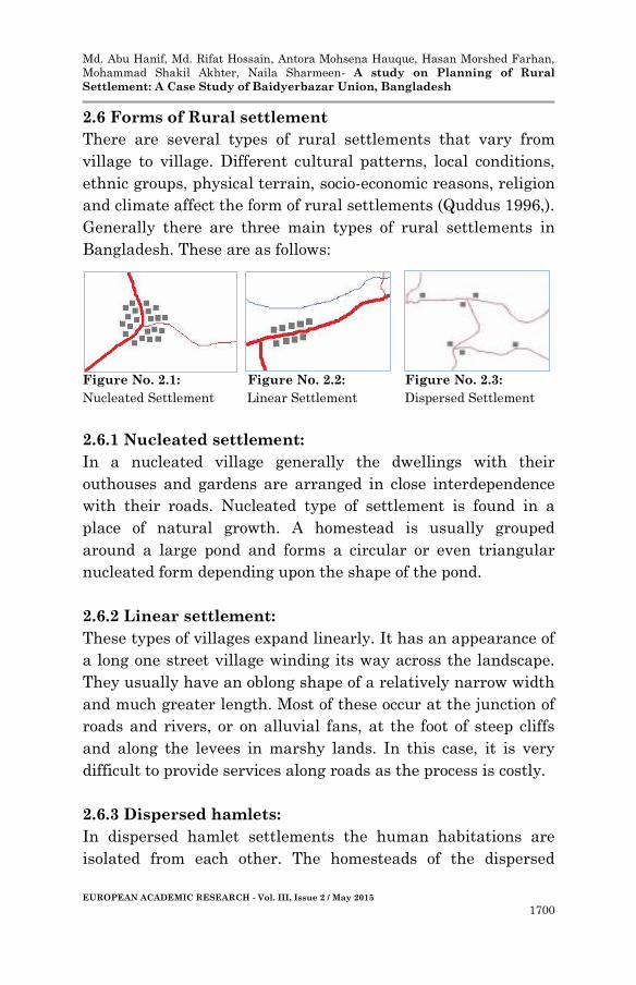
2.6 Forms of Rural settlement
There are several types of rural settlements that vary from
village to village. Different cultural patterns, local conditions,
ethnic groups, physical terrain, socio-economic reasons, religion
and climate affect the form of rural settlements (Quddus 1996,).
Generally there are three main types of rural settlements in
Bangladesh. These are as follows:
Figure No. 2.1: Figure No. 2.2: Figure No. 2.3:
Nucleated Settlement Linear Settlement Dispersed Settlement
2.6.1 Nucleated settlement:
In a nucleated village generally the dwellings with their
outhouses and gardens are arranged in close interdependence
with their roads. Nucleated type of settlement is found in a
place of natural growth. A homestead is usually grouped
around a large pond and forms a circular or even triangular
nucleated form depending upon the shape of the pond.
2.6.2 Linear settlement:
These types of villages expand linearly. It has an appearance of
a long one street village winding its way across the landscape.
They usually have an oblong shape of a relatively narrow width
and much greater length. Most of these occur at the junction of
roads and rivers, or on alluvial fans, at the foot of steep cliffs
and along the levees in marshy lands. In this case, it is very
difficult to provide services along roads as the process is costly.
2.6.3 Dispersed hamlets:
In dispersed hamlet settlements the human habitations are
isolated from each other. The homesteads of the dispersed
Md. Abu Hanif, Md. Rifat Hossain, Antora Mohsena Hauque, Hasan Morshed Farhan,
Mohammad Shakil Akhter, Naila Sharmeen- A study on Planning of Rural
Settlement: A Case Study of Baidyerbazar Union, Bangladesh
EUROPEAN ACADEMIC RESEARCH - Vol. III, Issue 2 / May 2015
1701
settlements are separated and built around the water tank.
Some kind of dispersed settlements are also noticed in areas of
recent reclaimed land of suburban. In this case more
agricultural land becomes the place for living and new homes
are created here and there in a scattered way.
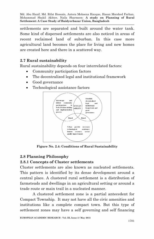
2.7 Rural sustainability
Rural sustainability depends on four interrelated factors:
Community participation factors
The decentralized legal and institutional framework
Good governance
Technological assistance factors
Figure No. 2.4: Conditions of Rural Sustainability
2.8 Planning Philosophy
2.8.1 Concepts of Cluster settlements
Cluster settlements are also known as nucleated settlements.
This pattern is identified by its dense development around a
central place. A clustered rural settlement is a distribution of
farmsteads and dwellings in an agricultural setting or around a
trade route or main trail in a nucleated manner.
A clustered settlement zone is a partial antecedent for
Compact Township. It may not have all the civic amenities and
institutions like a complete compact town. But this type of
settlement zones may have a self governing and self financing

Md. Abu Hanif, Md. Rifat Hossain, Antora Mohsena Hauque, Hasan Morshed Farhan,
Mohammad Shakil Akhter, Naila Sharmeen- A study on Planning of Rural
Settlement: A Case Study of Baidyerbazar Union, Bangladesh
EUROPEAN ACADEMIC RESEARCH - Vol. III, Issue 2 / May 2015
1702
agglomeration of houses, hospitals, schools, markets, rural
industries and local government units to serve its population.
Its main objective is to cluster the rural settlements and
amenities into close proximity to gain economies of
agglomeration. Consequently this releases precious agricultural
land and ponds for increasing production of crops and fisheries.
2.8.2 Characteristics of Cluster settlements
The characteristics of the cluster settlement zones are listed
below:
Generally forms a regular shape like circular, square or
rectangular.
Small nucleated settlements can also appear in a
scattered form. These are common almost all over the
central valley flat of the flood plains.
All the houses in this zone are grouped and attached to
one another.
Its size must be small enough so that it can be well
connected to every corner of the zone.
2.8.3 Advantage of Cluster settlements
Clustered settlement zones have the following advantages:
Distance between settlements and between houses
within settlements is large.
Cost of road construction is comparatively less.
Provision of water supply and electricity is less costly.
Utilities and service facilities are easy to provide.
High concentration of population makes it easy to
provide the farmers with an adequate level of services.
Simplifies even and fair distribution of most suitable
farmlands among farmers.
If government or private developers build cluster
settlement zones with adequate amenities and facilities
(like school, market, bazaar, hospital, office, electricity,
7

Md. Abu Hanif, Md. Rifat Hossain, Antora Mohsena Hauque, Hasan Morshed Farhan,
Mohammad Shakil Akhter, Naila Sharmeen- A study on Planning of Rural
Settlement: A Case Study of Baidyerbazar Union, Bangladesh
EUROPEAN ACADEMIC RESEARCH - Vol. III, Issue 2 / May 2015
1703
sanitation etc) all over the country it will reduce the
burden of immigration on large cities.
2.8.4 Feasibility of Cluster settlements:
Cluster settlement zones increases savings as cost of
road construction, provision of water and electricity
supply, provision of utilities and services are relatively
less costly settlements are located close to each other.
Practice of such kind of settlement frees up the
resources that are being used to facilitate the burden of
excess population on the large cities.
Precious land and ponds are released if rural people
move to these cluster settlement zones. As a result the
production of crops and fisheries increase.
Living in these kinds of settlements facilitates easy
access to education, health, business etc.
Ultimately it will improve the overall living condition of
the rural people.
2.8.5 Criticism of Cluster settlements
Greater travelling distance between dwelling units and
farm lands.
People cannot prevent their land from theft as they do
not live adjacent to their lands.
Most of the times rural people do not want to leave their
ancestral homes and enter into a new kind of place to
live.
3. Profile of the study Area
Baidyerbazar union of Sonargaon upazilla has been assigned to
carry out the study with a view to prepare a suitable physical
plan for the future. This requires a thorough analysis of the
area’s existing profile. This chapter includes physical
demographic, housing, social characteristics, economic and
Md. Abu Hanif, Md. Rifat Hossain, Antora Mohsena Hauque, Hasan Morshed Farhan,
Mohammad Shakil Akhter, Naila Sharmeen- A study on Planning of Rural
Settlement: A Case Study of Baidyerbazar Union, Bangladesh
EUROPEAN ACADEMIC RESEARCH - Vol. III, Issue 2 / May 2015
1704
infrastructure facilities, utility facilities and agricultural
development of the study area.
3.1 Physical Characteristics
3.1.1 Location
Baidyerbazar union is in Sonargaon Upazilla of Narayanganj
District. It is situated at the South East side of DMDP. Its
geographical location is between 23032’ and 23046’ north
latitudes and between 90031’ and 90041’ east longitudes.
3.1.2 Geographic Position
Baidyerbazar union is surrounded by Araihajar and Rupganj
upazilla at the north, Munshiganj sadar upazilla at the south,
Homna upazilla at the east and Gajaria upazilla and
Narayanganj sadar upazilla at the west. There are many water
bodies present in the area. Two main rivers Meghna and
Brahmaputra pass by the union from east and west side
respectively.
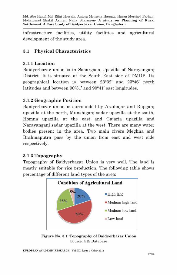
3.1.3 Topography
Topography of Baidyerbazar Union is very well. The land is
mostly suitable for rice production. The following table shows
percentage of different land types of the area:
Figure No. 3.1: Topography of Baidyerbazar Union
Source: GIS Database
Md. Abu Hanif, Md. Rifat Hossain, Antora Mohsena Hauque, Hasan Morshed Farhan,
Mohammad Shakil Akhter, Naila Sharmeen- A study on Planning of Rural
Settlement: A Case Study of Baidyerbazar Union, Bangladesh
EUROPEAN ACADEMIC RESEARCH - Vol. III, Issue 2 / May 2015
1705
The chart shows that, 50% land of this union is medium high
and 5% land is low in height.
3.1.4 Existing Land Use Pattern
Baidyerbazar union has a total area of 6770.42 acre and various
kinds of land uses are distributed into it. The existing land use
pattern of Baidyerbazar union is given below:
Table No. 3.1: Existing Land Use pattern of Baidyerbazar Union
Land Use Area (acre) Area (%)
Manufacturing & Processing Activity 12.6 0.19
Government Service 1.18 0.02
Education & Resources 71.75 1.06
Commercial Activity 32 0.47
Transport & Communication 2.37 0.04
Rural Settlement Zone 1467.77 21.68
Agricultural Zone 3174.63 46.89
Circular Network 10.2 0.15
Recreational Facility 1243.2 18.36
Service Activity 7.72 0.11
Water body 747 11.03
Total area 6770.42 100.00
The table shows that, almost half portion of the land is used for
agriculture. 21.68% of the land is being used for the rural
peoples dwelling units. Recreational facilities include open
spaces and play fields and contain 18.36% of the study area.
Ponds, streams, lakes and portion of rivers that surpasses the
total area occupies 747 acre of the land in total.
3.2 Demographic Characteristics
The following table shows the population of Baidyerbazar
Union according to BBS 2001.
Table No. 3.2: Demographic Characteristics of Baidyerbazar Union
Population Number Percentages
Male 10250 51.78%
Female 9547 48.22%
Total 19797 100%
Source: RAJUK. 2010
Source: BBS 2001
Md. Abu Hanif, Md. Rifat Hossain, Antora Mohsena Hauque, Hasan Morshed Farhan,
Mohammad Shakil Akhter, Naila Sharmeen- A study on Planning of Rural
Settlement: A Case Study of Baidyerbazar Union, Bangladesh
EUROPEAN ACADEMIC RESEARCH - Vol. III, Issue 2 / May 2015
1706
Density: 2.89 persons/acre
Number of household: 3927
3.3 Housing Characteristics
Structure type symbolizes physical and socio-economic scenario
of an area. According to structure materials, generally three
categories of structure have been found. Most of them are
kutcha and few are semi pucca and pucca.
3.4 Economic Characteristics
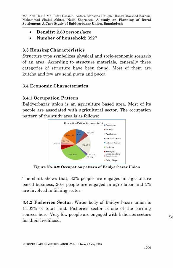
3.4.1 Occupation Pattern
Baidyerbazar union is an agriculture based area. Most of its
people are associated with agricultural sector. The occupation
pattern of the study area is as follows:
Figure No. 3.2: Occupation pattern of Baidyerbazar Union
The chart shows that, 32% people are engaged in agriculture
based business, 20% people are engaged in agro labor and 5%
are involved in fishing sector.
3.4.2 Fisheries Sector: Water body of Baidyerbazar union is
11.03% of total land. Fisheries sector is one of the earning
sources here. Very few people are engaged with fisheries sectors
for their livelihood.
Source: BBS 2001
Md. Abu Hanif, Md. Rifat Hossain, Antora Mohsena Hauque, Hasan Morshed Farhan,
Mohammad Shakil Akhter, Naila Sharmeen- A study on Planning of Rural
Settlement: A Case Study of Baidyerbazar Union, Bangladesh
EUROPEAN ACADEMIC RESEARCH - Vol. III, Issue 2 / May 2015
1707
3.4.3 Rural Industry Sector
Being located along the Narayanganj port, Baidyerbazar union
contains some rural industries. These industries are mainly
agro-based. Raw materials of these industries are collected from
mainly agricultural production. Rice Mill, Textile & Garments
industry, Dying Industry, Knitting Industry, Packaging
Industry, Poultry Farm, Saw Mill, Re-Rolling Mills, Cosmetics
& Toiletries Industry and other Food Manufacturing Industry
are the main industries here.
3.5 Social Characteristics
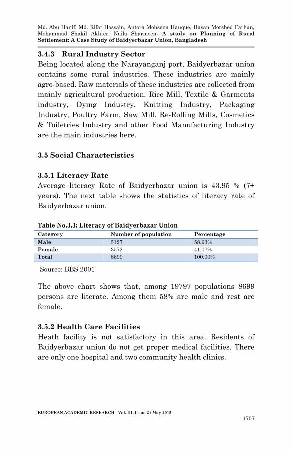
3.5.1 Literacy Rate
Average literacy Rate of Baidyerbazar union is 43.95 % (7+
years). The next table shows the statistics of literacy rate of
Baidyerbazar union.
Table No.3.3: Literacy of Baidyerbazar Union
Category Number of population Percentage
Male 5127 58.93%
Female 3572 41.07%
Total 8699 100.00%
The above chart shows that, among 19797 populations 8699
persons are literate. Among them 58% are male and rest are
female.
3.5.2 Health Care Facilities
Heath facility is not satisfactory in this area. Residents of
Baidyerbazar union do not get proper medical facilities. There
are only one hospital and two community health clinics.
Source: BBS 2001
Md. Abu Hanif, Md. Rifat Hossain, Antora Mohsena Hauque, Hasan Morshed Farhan,
Mohammad Shakil Akhter, Naila Sharmeen- A study on Planning of Rural
Settlement: A Case Study of Baidyerbazar Union, Bangladesh
EUROPEAN ACADEMIC RESEARCH - Vol. III, Issue 2 / May 2015
1708
3.6 Infrastructure facilities
3.6.1 Roads and Transportation Services
Existing road network and transport system is not appropriate
for modern transport facilities. There is no footpath for
pedestrians. There are three types of roads found here. A Major
thoroughfare road is of 60 feet width. Major distributor roads
and village roads are of 12 feet 8 feet respectively.
3.6.2 Market and Growth Centre
Market and growth centre are the influencing factors of
development in an area. There are 15 markets and one growth
centre in the study area.
3.6.3 Religious Centre
There are mainly two types of people found in this area such as
Muslim and Hindu. There are 15 mosques and 4 temples for
their religious purposes.
3.6.4 Training Institution
There is only one training institute to train up the industrial
labors. The training institute is run by Ministry of Industry of
Bangladesh.
3.6.5 Bank and Office
There are two banks which are used for financial purposes.
There are eight offices to execute the official works throughout
the union such as Union parishad office, Agricultural office,
Security office and Medical office etc.
3.7 Utility facilities
Water supply
Water supply of Baidyerbazar union is satisfactory. There are
three types of source of drinking water. Main source of drinking
water is Tube well.
Md. Abu Hanif, Md. Rifat Hossain, Antora Mohsena Hauque, Hasan Morshed Farhan,
Mohammad Shakil Akhter, Naila Sharmeen- A study on Planning of Rural
Settlement: A Case Study of Baidyerbazar Union, Bangladesh
EUROPEAN ACADEMIC RESEARCH - Vol. III, Issue 2 / May 2015
1709
Electricity supply
The condition of electricity is satisfactory in the Baidyerbazar
union. The GIS map shows that electricity is available
throughout the union.
Gas supply
Residents have said that condition of Gas supply is not
satisfactory. They have also said that, at present there is no
more Gas supply in the union.
Sanitation situation
The sanitation system is satisfactory and hygienic.
3.8 Agricultural Development
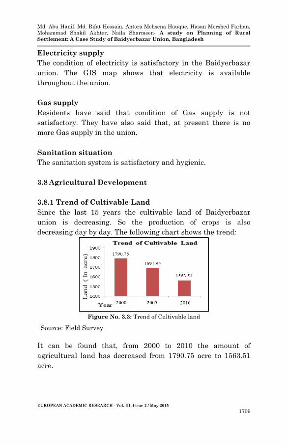
3.8.1 Trend of Cultivable Land
Since the last 15 years the cultivable land of Baidyerbazar
union is decreasing. So the production of crops is also
decreasing day by day. The following chart shows the trend:
Figure No. 3.3: Trend of Cultivable land
It can be found that, from 2000 to 2010 the amount of
agricultural land has decreased from 1790.75 acre to 1563.51
acre.
Source: Field Survey

Md. Abu Hanif, Md. Rifat Hossain, Antora Mohsena Hauque, Hasan Morshed Farhan,
Mohammad Shakil Akhter, Naila Sharmeen- A study on Planning of Rural
Settlement: A Case Study of Baidyerbazar Union, Bangladesh
EUROPEAN ACADEMIC RESEARCH - Vol. III, Issue 2 / May 2015
1710
3.8.2 Cropping Pattern
Rice is the main crop of Baidyerbazar union. Vegetables also
grow in huge amount here. The cropping pattern of
Baidyerbazar union is shown by the following table:
Table No. 3.4: Cropping Pattern of Baidyerbazar Union
Type of crop Area of land(in hector) Percentages
Boro 246 24.6
Wheat 5 0.5
Potato 15 1.5
Aman 250 25
Lentil 56 5.6
Sugarcane 6 0.6
Mustard 93 9.3
Sesame 54 5.4
Vegetables 275 27.5
Total 1000 100
The table indicates that, vegetables grow in most of the land.
Rice is produced in total 496 (49.6%) hector land every year.
Wheat grows in only 5 acre land.
3.8.3 Agricultural Production
The agricultural production in the area is satisfactory and the
average production in a year is as follows:
Table No. 3.5: Agricultural Production of Baidyerbazar Union
Type of Crop Production Per Hector(in ton)
Boro 6.5
Wheat 3.5
Potato 25
Amon 1.5
Lentil 1.1
Sugarcane 10
Mustard 1
Sesame 0.6
Source: Field Survey
Source: Field Survey
Md. Abu Hanif, Md. Rifat Hossain, Antora Mohsena Hauque, Hasan Morshed Farhan,
Mohammad Shakil Akhter, Naila Sharmeen- A study on Planning of Rural
Settlement: A Case Study of Baidyerbazar Union, Bangladesh
EUROPEAN ACADEMIC RESEARCH - Vol. III, Issue 2 / May 2015
1711
From the table it is visible that, Potato has the maximum
production per hector followed by Sugarcane.
3.8.4 Comparison between Last Three Years Production
From field survey, last three years crop production has been
found which are shown in the next table:
Table No. 3.6: Crop Production (in hector): 2008-2011
Year Boro Wheat Potato Aman Lentil Sugarcane Mustard Sesame Vegetables
2008-2009 255 33 28 230 66 7 100 54 280
2009-2010 245 27 20 250 63 7 98 52 275
2010-2011 246 5 15 250 56 6 93 54 275
Percentage 24.6 0.5 1.5 25 5.6 0.6 9.3 5.4 27.5
It is noticeable from the table that, wheat production is
decreasing at an alarming rate whereas Boro and Amon
production has decreased very little.
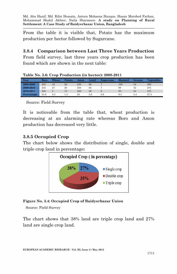
3.8.5 Occupied Crop
The chart below shows the distribution of single, double and
triple crop land in percentage:
Figure No. 3.4: Occupied Crop of Baidyerbazar Union
The chart shows that 38% land are triple crop land and 27%
land are single crop land.
Source: Field Survey
Source: Field Survey
Md. Abu Hanif, Md. Rifat Hossain, Antora Mohsena Hauque, Hasan Morshed Farhan,
Mohammad Shakil Akhter, Naila Sharmeen- A study on Planning of Rural
Settlement: A Case Study of Baidyerbazar Union, Bangladesh
EUROPEAN ACADEMIC RESEARCH - Vol. III, Issue 2 / May 2015
1712
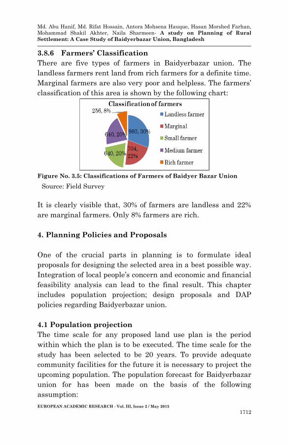
3.8.6 Farmers’ Classification
There are five types of farmers in Baidyerbazar union. The
landless farmers rent land from rich farmers for a definite time.
Marginal farmers are also very poor and helpless. The farmers’
classification of this area is shown by the following chart:
Figure No. 3.5: Classifications of Farmers of Baidyer Bazar Union
It is clearly visible that, 30% of farmers are landless and 22%
are marginal farmers. Only 8% farmers are rich.
4. Planning Policies and Proposals
One of the crucial parts in planning is to formulate ideal
proposals for designing the selected area in a best possible way.
Integration of local people’s concern and economic and financial
feasibility analysis can lead to the final result. This chapter
includes population projection; design proposals and DAP
policies regarding Baidyerbazar union.
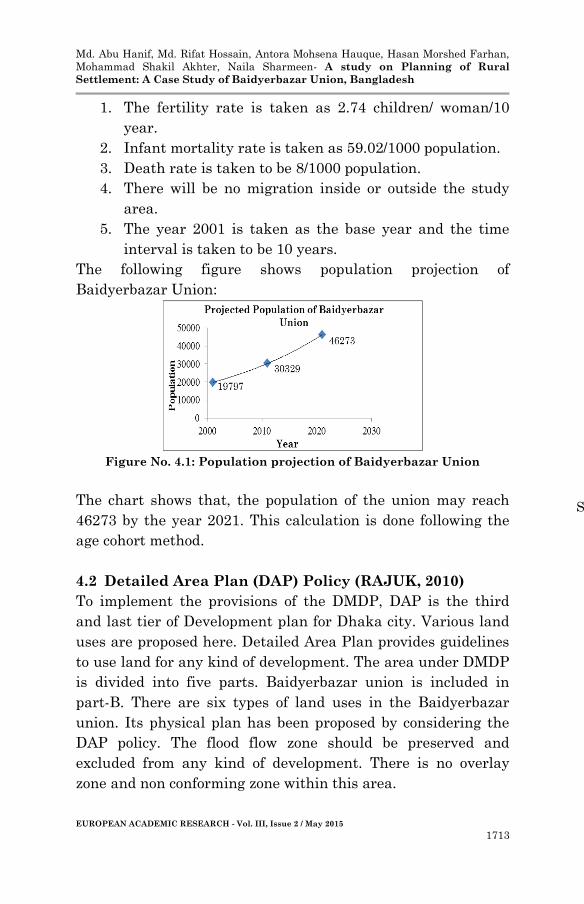
4.1 Population projection
The time scale for any proposed land use plan is the period
within which the plan is to be executed. The time scale for the
study has been selected to be 20 years. To provide adequate
community facilities for the future it is necessary to project the
upcoming population. The population forecast for Baidyerbazar
union for has been made on the basis of the following
assumption:
Source: Field Survey
Md. Abu Hanif, Md. Rifat Hossain, Antora Mohsena Hauque, Hasan Morshed Farhan,
Mohammad Shakil Akhter, Naila Sharmeen- A study on Planning of Rural
Settlement: A Case Study of Baidyerbazar Union, Bangladesh
EUROPEAN ACADEMIC RESEARCH - Vol. III, Issue 2 / May 2015
1713
1. The fertility rate is taken as 2.74 children/ woman/10
year.
2. Infant mortality rate is taken as 59.02/1000 population.
3. Death rate is taken to be 8/1000 population.
4. There will be no migration inside or outside the study
area.
5. The year 2001 is taken as the base year and the time
interval is taken to be 10 years.
The following figure shows population projection of
Baidyerbazar Union:
Figure No. 4.1: Population projection of Baidyerbazar Union
The chart shows that, the population of the union may reach
46273 by the year 2021. This calculation is done following the
age cohort method.
4.2 Detailed Area Plan (DAP) Policy (RAJUK, 2010)
To implement the provisions of the DMDP, DAP is the third
and last tier of Development plan for Dhaka city. Various land
uses are proposed here. Detailed Area Plan provides guidelines
to use land for any kind of development. The area under DMDP
is divided into five parts. Baidyerbazar union is included in
part-B. There are six types of land uses in the Baidyerbazar
union. Its physical plan has been proposed by considering the
DAP policy. The flood flow zone should be preserved and
excluded from any kind of development. There is no overlay
zone and non conforming zone within this area.
Source: BBS 2001
16
Md. Abu Hanif, Md. Rifat Hossain, Antora Mohsena Hauque, Hasan Morshed Farhan,
Mohammad Shakil Akhter, Naila Sharmeen- A study on Planning of Rural
Settlement: A Case Study of Baidyerbazar Union, Bangladesh
EUROPEAN ACADEMIC RESEARCH - Vol. III, Issue 2 / May 2015
1714
4.3 Planning Proposal
Proposals for each and every sector such as homestead,
Community facilities, Utility facilities, Road network,
Irrigation canal and Rural industries has been provided
individually.
4.3.1 Proposal for Rural Homestead:
Each Homestead will acquire 0.1 acre land.
The homesteads will be clustered under a block.
Each block will acquire 6 acre land approximately.
Open space and vegetation will surround the clusters of
homesteads.
Justification: It becomes economically feasible to provide
electricity, water and gas supply to all the housing units if
these are clustered into groups. It ensures proper utilization of
land and convenient rural life. Thus ample space for vegetation
is also easy to acquire.
4.3.2 Proposal for Community Facilities:
Basic requirements like Mosque and community centers
will be established in every zone.
Community activity center, Police outpost, Bank,
Hospital, Bus stand, Grave yard will be found only in
CBD.
Justification: Mosque, community centers, health complex are
common in every zone. But Police outpost, Bank, Hospital,
college are located at the central zone to serve the total union
because it is more convenient for all residents.
4.3.3 Proposal for Utility Facilities:
Facilities found in CBD will be utility stations for Gas
and Electricity, Service Station, Union Parishad Office,
Agricultural office and Training center for farmers.
One central food godown of 25000 ton capacity will be
established in CBD near the major thoroughfare road. 17
Md. Abu Hanif, Md. Rifat Hossain, Antora Mohsena Hauque, Hasan Morshed Farhan,
Mohammad Shakil Akhter, Naila Sharmeen- A study on Planning of Rural
Settlement: A Case Study of Baidyerbazar Union, Bangladesh
EUROPEAN ACADEMIC RESEARCH - Vol. III, Issue 2 / May 2015
1715
Justification: Main stations for each service are located at
CBD because this location facilitates transport. It is also
effortless to get administrative support.
4.3.4 Proposal for Road network:
Existing roads will be kept.
Roads proposed in DAP will be established.
Roads will be classified into-
o Major Thoroughfare : 60feet
o Major Distributor : 12 feet
o Village road(Access road): 8 feet
Justification: Major thoroughfare will connect the union with
the upazilla. Major distributor will connect the union with
village or wards. Only village roads will be kutcha and will give
access to every rural homestead.
4.3.5 Proposal for Irrigation Canal:
Irrigation Canal will be designed based on topography
and contour of the area.
Canal will run from higher to lower level of lands.
Canal width varies from 4 feet to 1 foot as per
requirement.
Justification: It is provided to facilitate irrigation to all
agricultural lands at maximum period of the year.
4.3.6 Proposal for Rural Industries:
Industries of this study area will be kept in their
former location.
These industries will be adjacent to the major
thoroughfare road to facilitate easy
transportation.
Justification: As Baidyerbazar union is an agriculture based
area, most of its industries are agro based. The raw materials
come from the union itself. Its location will make transportation
of goods or raw materials easy as it is beside the major

Md. Abu Hanif, Md. Rifat Hossain, Antora Mohsena Hauque, Hasan Morshed Farhan,
Mohammad Shakil Akhter, Naila Sharmeen- A study on Planning of Rural
Settlement: A Case Study of Baidyerbazar Union, Bangladesh
EUROPEAN ACADEMIC RESEARCH - Vol. III, Issue 2 / May 2015
1716
thoroughfare and well connected to the rest of the union. In the
off seasons the labors can work in these industries.
5. Design procedure and Space Calculation
This chapter includes proposed land use for Baidyerbazar
union, procedure and space calculation of the design and
projection of Agricultural production.
5.1 Proposed Land Use
Bangladesh has an agriculture based economy. It has been
found from the field visit that agriculture has always been the
main land use of Baidyerbazar union. But since the last 10
years the amount of agricultural land of this union has been
decreasing at a rate of 1.3% per year. This is because of the
increasing population and unplanned land absorption.
Table 5.1: Proposed Land Use (in acre and percentage)
From the chart above, it can be found that maximum of land is
proposed for agricultural purpose and that is 67.1 % of the total
area. After that, priority has been given to rural settlement
zones allocating an area of 900 acre which is 13.3% of the total
union. Existing 747 acre area has been kept as water body. 40
acre land has been assigned for provision of community
facilities.
Land Use Area(acre) Area (percentage)
Manufacturing and Industrial Activity 20 0.3%
Community Facility 40 0.6%
Irrigation channel 10 0.15%
Commercial Activity 32 0.47%
Road 50 0.74%
Rural Settlement Zone 900 13.3%
Agricultural Zone 4543 67.1%
Open Space 418 6.17%
Service Activity 10 0.15%
Water body 747 11.02%
Total 6770 100%
19

Md. Abu Hanif, Md. Rifat Hossain, Antora Mohsena Hauque, Hasan Morshed Farhan,
Mohammad Shakil Akhter, Naila Sharmeen- A study on Planning of Rural
Settlement: A Case Study of Baidyerbazar Union, Bangladesh
EUROPEAN ACADEMIC RESEARCH - Vol. III, Issue 2 / May 2015
1717
5.2 Design Procedure
The philosophy of the design is to cluster the rural settlements,
community and utility facilities into different zones to acquire
maximum land for agricultural use. Considering the existing
rural settlements and roads, 5 clustered zones have been
proposed for Baidyerbazar union. These 5 zones fall under 3
proto types such as:
Proto Type 1: Residential & Industrial Zone-Zone A
Proto Type 2: Residential Zone-Zone B , Zone D,
Zone E
Proto Type 3: CBD-Zone C
5.2.1 Proto Type 1: Residential & Industrial Zone
5.2.1.1 Zone A
Location: This zone is situated at the northwest side of the
union beside the Brahmaputra River. The major thoroughfare
passes through this zone and connects the rural industrial area
with it. This zone mainly accommodates the labors working in
these industries.
Area: 118.9 acre
Population: 8000
Density: 67 persons per acre
Amenity Facilities: The amenity facilities serving the whole
zone are clustered in its central location so that these are easily
accessible by everyone. The list of amenities for this zone is
given below:
Table 5.2: Amenity Facilities of Zone A
Facilities Number
Primary School 1
Secondary School 1
Play Field 2
Health Complex 1
Community Centre 1
Mosque 1
Kutcha Bazar 1
Md. Abu Hanif, Md. Rifat Hossain, Antora Mohsena Hauque, Hasan Morshed Farhan,
Mohammad Shakil Akhter, Naila Sharmeen- A study on Planning of Rural
Settlement: A Case Study of Baidyerbazar Union, Bangladesh
EUROPEAN ACADEMIC RESEARCH - Vol. III, Issue 2 / May 2015
1718
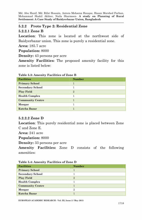
5.2.2 Proto Type 2: Residential Zone
5.2.2.1 Zone B
Location: This zone is located at the northwest side of
Baidyerbazar union. This zone is purely a residential zone.
Area: 185.7 acre
Population: 8000
Density: 43 persons per acre
Amenity Facilities: The proposed amenity facility for this
zone is listed below:
Table 5.3: Amenity Facilities of Zone B
Facilities Number
Primary School 1
Secondary School 1
Play Field 2
Health Complex 1
Community Centre 1
Mosque 1
Kutcha Bazar 1
5.2.2.2 Zone D
Location: This purely residential zone is placed between Zone
C and Zone E.
Area: 241 acre
Population: 8000
Density: 33 persons per acre
Amenity Facilities: Zone D consists of the following
amenities:
Table 5.4: Amenity Facilities of Zone D
Facilities Number
Primary School 1
Secondary School 1
Play Field 2
Health Complex 1
Community Centre 1
Mosque 2
Kutcha Bazar 1
Md. Abu Hanif, Md. Rifat Hossain, Antora Mohsena Hauque, Hasan Morshed Farhan,
Mohammad Shakil Akhter, Naila Sharmeen- A study on Planning of Rural
Settlement: A Case Study of Baidyerbazar Union, Bangladesh
EUROPEAN ACADEMIC RESEARCH - Vol. III, Issue 2 / May 2015
1719
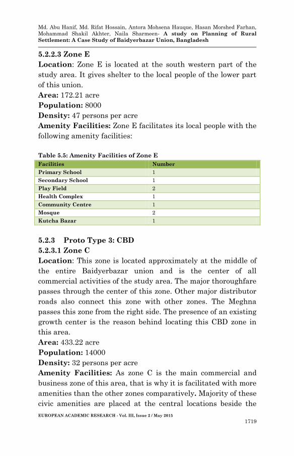
5.2.2.3 Zone E
Location: Zone E is located at the south western part of the
study area. It gives shelter to the local people of the lower part
of this union.
Area: 172.21 acre
Population: 8000
Density: 47 persons per acre
Amenity Facilities: Zone E facilitates its local people with the
following amenity facilities:
Table 5.5: Amenity Facilities of Zone E
Facilities Number
Primary School 1
Secondary School 1
Play Field 2
Health Complex 1
Community Centre 1
Mosque 2
Kutcha Bazar 1
5.2.3 Proto Type 3: CBD
5.2.3.1 Zone C
Location: This zone is located approximately at the middle of
the entire Baidyerbazar union and is the center of all
commercial activities of the study area. The major thoroughfare
passes through the center of this zone. Other major distributor
roads also connect this zone with other zones. The Meghna
passes this zone from the right side. The presence of an existing
growth center is the reason behind locating this CBD zone in
this area.
Area: 433.22 acre
Population: 14000
Density: 32 persons per acre
Amenity Facilities: As zone C is the main commercial and
business zone of this area, that is why it is facilitated with more
amenities than the other zones comparatively. Majority of these
civic amenities are placed at the central locations beside the
Md. Abu Hanif, Md. Rifat Hossain, Antora Mohsena Hauque, Hasan Morshed Farhan,
Mohammad Shakil Akhter, Naila Sharmeen- A study on Planning of Rural
Settlement: A Case Study of Baidyerbazar Union, Bangladesh
EUROPEAN ACADEMIC RESEARCH - Vol. III, Issue 2 / May 2015
1720
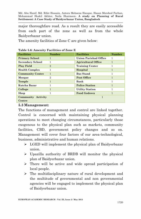
major thoroughfare road. As a result they are easily accessible
from each part of the zone as well as from the whole
Baidyerbazar union.
The amenity facilities of Zone C are given below:
Table 5.6: Amenity Facilities of Zone E
Facilities Number Facilities Number
Primary School 1 Union Parishad Office 1
Secondary School 1 Agricultural Office 1
Play Field 2 Training Center 1
Health Complex 1 Hospital 1
Community Centre 1 Bus Stand 1
Mosque 2 Post Office 1
Temple 1 Bank 1
Kutcha Bazar 1 Police Station 1
College 1 Utility Station 1
Shop 1 Food Godown 1
Community Activity
Centre
1
5.3 Management:
The functions of management and control are linked together.
Control is concerned with maintaining physical planning
operations to meet changing circumstances, particularly those
exogenous to the physical plan such as markets, community
facilities, CBD, government policy changes and so on.
Management will cover four factors of our area-technological,
business, administrative and human relations.
LGED will implement the physical plan of Baidyerbazar
union.
Upazilla authority of BRDB will monitor the physical
plan of Baidyerbazar union.
There will be active and wide spread participation of
local people.
The multidisciplinary nature of rural development and
the multitude of governmental and non governmental
agencies will be engaged to implement the physical plan
of Baidyerbazar union.
Md. Abu Hanif, Md. Rifat Hossain, Antora Mohsena Hauque, Hasan Morshed Farhan,
Mohammad Shakil Akhter, Naila Sharmeen- A study on Planning of Rural
Settlement: A Case Study of Baidyerbazar Union, Bangladesh
EUROPEAN ACADEMIC RESEARCH - Vol. III, Issue 2 / May 2015
1721
Integration and coordination among various
development agencies will be properly maintained to
make successful physical plan of Baidyerbazar union.
5.4 Projected Agricultural Production
5.4.1 Total Projected Agricultural Land = 1839.27 Ha.
5.4.2 Rice Production
Different types of crops are grown in different types of lands at
different seasons. Amon and Boro are the main crops of
Baidyerbazar union. Vegetables also grow in a large amount in
this area. The following table shows Boro and Amon rice
production in ton/Ha.
Table No. 5.7: Crop Production
Crop Amount
Boro 6.5 ton/Ha
Amon 1.5 ton/Ha
Regarding this annual production of Amon and Boro are given
below:
Table No. 5.8: Annual Rice Production
Occupied Crop Area
( in Ha)
Amon
Production
( in ton)
Boro
production
(in ton)
Total Rice
Production
(in ton)
Single crop 735.71 1103.56 -
9932.1 Double crop 919.64 1379.46 5977.66
Triple crop 183.927 275.89 1195.53
Total Rice production = 9932.1 ton
Annual Rice consumption = 0 .1646 ton/person (451
g/person/day)
Required production = 0.1646 ton/person * 46273 person
= 7616.5 ton
Source: Field Survey
Md. Abu Hanif, Md. Rifat Hossain, Antora Mohsena Hauque, Hasan Morshed Farhan,
Mohammad Shakil Akhter, Naila Sharmeen- A study on Planning of Rural
Settlement: A Case Study of Baidyerbazar Union, Bangladesh
EUROPEAN ACADEMIC RESEARCH - Vol. III, Issue 2 / May 2015
1722
Surplus production = 2315.6 ton
People served by surplus production = 2315.6 ton /0 .1646
ton/person
= 14068 person
6. Conclusion
The population is increasing in respect of time but land is still
the same. Under this consideration, at present, the burning
issue of the Dhaka city is to provide adequate housing and food
for this ever increasing population. On the other hand, the
main objective of planning is to ensure optimum utilization of
limited land. It is the proper land use planning that can
balance the ratio of environment and community facilities
within an area. Baidyerbazar, being one of the examples of
those rural areas where agricultural land is decreasing, is in
grave need for the aid of planning. Therefore, if proper planning
procedures are adopted according to the proposed plan, then
Baidyerbazar union would be a better place for housing and
employment for the people living within this area for a long
time in the future.
REFERENCES
1. Abdul, Quddus, 1996. Rural Development in Bangladesh.
Comilla, Bangladesh: Bangladesh Academy for Rural
Development (BARD).
2. Katar, Singh, 1986. Rural Development Principles, policies
and Management. New Delhi, India: Sage India Pvt Ltd.
3. RAJUK, 2010. Preparation of Detailed Area Plan for Dhaka
Metropolitan Development Planning (DMDP) area”, Group
B; Final Plan. Dhaka, Bangladesh: Engineering and
Planning Consultants Ltd.