A Situation Analysis of Urban Disaster Risk Management in ...lead\attachments\projects\PDI-ON Urban...
91
A Situation Analysis of Urban Disaster Risk Management in Pakistan Based on Case Studies of Six Major Cities LEAD Pakistan 11/22/2013
-
Upload
duongnguyet -
Category
Documents
-
view
214 -
download
0
Transcript of A Situation Analysis of Urban Disaster Risk Management in ...lead\attachments\projects\PDI-ON Urban...

A Situation Analysis of Urban Disaster Risk Management in Pakistan
Based on Case Studies of Six Major Cities
LEAD Pakistan 11/22/2013

[Type text]
Contents List of Abbreviations ..................................................................................................................................... 6
Executive Summary ....................................................................................................................................... 8
1 Purpose and Methodology of the Study ............................................................................................... 9
1.1 Purpose ......................................................................................................................................... 9
1.2 Methodology and Approach ......................................................................................................... 9
1.2.1 Pre-Inception ................................................................................................................................ 9
1.2.1 Inception Work ................................................................................................................... 11
2 2. b. Pakistan and Disaster Risk Reduction: An Overview ................................................................... 13
2.1 Introduction ................................................................................................................................ 13
2.2 Disaster Management in Pakistan Pre 2005 ............................................................................... 13
2.3 Disaster Management Post 2005 ................................................................................................ 15
2.4 Disaster Management Today ...................................................................................................... 17
3 Urban Situation of Pakistan: A Disaster in the Making? ..................................................................... 18
4 Case Study 1: Peshawar ...................................................................................................................... 21
4.1 Introduction ................................................................................................................................ 21
4.2 Disaster Profile ............................................................................................................................ 22
4.2.1 Flood ................................................................................................................................... 23
4.2.2 Wind Storms ........................................................................................................................ 24
4.2.3 Earthquakes ........................................................................................................................ 24
4.2.4 Urban Fire, Terrorism and Epidemics ................................................................................. 24
4.3 Institutional and Administrative Setup ....................................................................................... 25
4.3.1 Urban Planning .................................................................................................................... 25
4.3.2 Disaster Management ......................................................................................................... 26
4.4 Stakeholder Analysis ................................................................................................................... 26
4.5 Conclusion ................................................................................................................................... 29
5 Case Study 2: Quetta ........................................................................................................................... 30
5.1 Introduction ................................................................................................................................ 30
5.2 Disaster Profile ............................................................................................................................ 31
5.2.1 Earthquake: ......................................................................................................................... 32
[Type text]
5.2.2 Drought: .............................................................................................................................. 32
5.2.3 Water: ................................................................................................................................. 33
5.2.4 Floods: ................................................................................................................................. 33
5.3 Institutional and Administrative Setup ....................................................................................... 33
5.3.1 Urban Planning .................................................................................................................... 33
5.3.2 Disaster Management ......................................................................................................... 34
5.4 Stakeholder Analysis: .................................................................................................................. 34
5.5 Conclusion ................................................................................................................................... 36
6 Case Study 3: Faisalabad ..................................................................................................................... 37
6.1 Introduction ................................................................................................................................ 37
6.2 Disaster Profile ............................................................................................................................ 37
6.3 Water & Sanitation ..................................................................................................................... 38
6.4 Health Hazards ............................................................................................................................ 39
6.5 Urban Floods: .............................................................................................................................. 40
6.6 Institutional and Administrative Setup ....................................................................................... 40
6.6.1 Urban Planning .................................................................................................................... 40
6.6.2 Disaster Management ......................................................................................................... 40
6.7 Stakeholder Analysis ................................................................................................................... 41
6.8 Conclusion ................................................................................................................................... 42
7 Case Study 4: Karachi .......................................................................................................................... 43
7.1 Introduction ................................................................................................................................ 43
7.2 Disaster Profile: ........................................................................................................................... 44
7.2.1 Earthquake & Tsunami: ....................................................................................................... 45
7.2.2 Rain & Flash Flooding: ......................................................................................................... 46
7.2.3 Nuclear Discharge: .............................................................................................................. 47
7.2.4 Health Hazards: ................................................................................................................... 47
7.2.5 Sea Level Rise & Cyclones: .................................................................................................. 47
7.3 Institutional and Administrative Setup ....................................................................................... 48
7.3.1 Urban Planning .................................................................................................................... 48
7.3.2 Disaster Management ......................................................................................................... 49
[Type text]
7.4 Stakeholder Analysis ................................................................................................................... 49
7.5 Conclusion ................................................................................................................................... 51
8 Case Study 5: Rawalpindi .................................................................................................................... 52
8.1 Introduction ................................................................................................................................ 52
8.2 Disaster Profile ............................................................................................................................ 53
8.2.1 Nullah Lai related Hazards .................................................................................................. 55
8.2.2 Earthquakes ........................................................................................................................ 56
8.2.3 Other hazards ...................................................................................................................... 56
8.3 Institutional and Administrative Arrangements ......................................................................... 57
8.3.1 Urban Planning .................................................................................................................... 57
8.3.2 Disaster Management ......................................................................................................... 58
8.4 Stakeholder Analysis ................................................................................................................... 58
8.5 Conclusion ................................................................................................................................... 60
9 Case Study 6: Gilgit ............................................................................................................................. 62
9.1 Introduction ................................................................................................................................ 62
9.2 Disaster Profile ............................................................................................................................ 63
9.2.1 Floods .................................................................................................................................. 65
9.2.2 Landslides and Avalanches .................................................................................................. 66
9.2.3 Earthquakes and others ...................................................................................................... 67
9.3 Institutional Arrangements ......................................................................................................... 67
9.3.1 Urban Planning .................................................................................................................... 67
9.3.2 Disaster Management ......................................................................................................... 67
9.4 Stakeholder Analysis ................................................................................................................... 68
10 Conclusions, Lessons Learnt and Recommendations ..................................................................... 71
10.1 Conclusions and Main Findings ................................................................................................... 71
10.2 Lessons Learnt ............................................................................................................................. 74
10.3 Recommendations: ..................................................................................................................... 75
10.3.1 HFA’s Ten Essential Areas ................................................................................................... 75
10.3.2 Other Recommendations .................................................................................................... 76
11 Annexures ....................................................................................................................................... 78

[Type text]
11.1 Annex 1: HFA Core Indicators and their Scope of Applicability for Pakistan .............................. 78
11.2 Annex 2: Questionnaire’s for City Stakeholders. ........................................................................ 80
11.3 Annex 3: Information Checklist for Cities ................................................................................... 90

[Type text]
List of Abbreviations
AHD Action for Humanitarian Development
BHU Basic Health Unit
BCS Balochistan Conservation Strategy
CBDRM Community Based Disaster Risk Management
CDO Civil Defence Organization
CFW Cash For Work
CPDM Disaster Preparedness and Management
CDGK City District Government Karachi
DCMC District Crisis Management Cell
DDMA District Disaster Management Authorities
DMCs Disaster Management Committees
DMP Disaster Management Plan
DRM Disaster Risk Management
DRR Disaster Risk Reduction
DRMP Disaster Risk Management Plan
EIA Environment Impact Assessment
ECP Election Commission of Pakistan
EPA Environment Protection Agency
ERPs Emergency Response Procedues
ERTs Emergency Response Teams
EWS Early Warning System
FAO Food and Agricultural Organization
FDA Faisalabad Development Authority
GHG Green House Gases
GOB Government of Balochistan
GLOF Glacial Lake Outburst Flood
HFA Hyogo Framework for Action
HH Household
HUSAR Heavy Urban Search and Rescue
ISWM Integrated Solid Waste Management
IUCN International Union for Conservation of Nature
LGSAT Local Government Self Assessment Tool
LCO Life Care Organization
KANNUP Karachi Nuclear Power Plant
KDA Karachi Development Authority
KPK Khyber Pakhtunkhwa
KSDP Karachi Strategic Development Plan
iMMAP Information Management and Mine Action Programs
JICA Japan International Cooperation Agency
NADRA National Database and Registration Authority
NDMA National Disaster Management Authority
NDMA National Disaster Management Act
NDP National Drainage Programme
NDMC National Disaster Management Commission
NDMO National Disaster Management Ordinance
NDRMF National Disaster Risk Management Framework
NGO Non-Governmental Organization
[Type text]
ON Oxfam Novib
P & DD Planning and Development Department
PBS Pakistan Bureau of Statistics
PCGIP Punjab Cities Governance Improvement Project
PDA Peshawar Development Authority
PDI Participatory Development Initiative
PDMA Provincial Disaster Management Authority
PID’s Provincial Irrigation and Power Departments
PMD Pakistan Meteorological Department
PRCS Pakistan Red Crescent Society
PSLM Pakistan Social and Living Standard Measurement Survey
QDA Quetta Development Authority
RMI Rehman Medical Institute
SCOPE Society for Conversation and Protection of Environment
SDPI Sustainable Development Policy Institute
SUPARCO Space and Upper Atmosphere Research Commission
TMA Tehsil Municipal Administration
WASA Water and Sanitation Agency
WAPDA Water and Power Development Authority
WWF World Wide Fund for Nature
UNHCR United Nations High Commissioner for Refugees
UNISDR United Nations International Strategy for Disaster Reduction
URC Urban Resource Centre
UU Urban Unit

[Type text]
Executive Summary This study has been undertaken by LEAD Pakistan in collaboration with Participatory
Development Initiative (PDI) and with the support of Oxfam Novib (ON). The purpose of the
Study was to develop a situation analysis of Urban Disaster Risk Management (DRM) with
reference to achieving the objectives of the Hyogo Framework for Action (HFA) in selected
urban areas of Pakistan. Being a pioneering initiative, major cities – with a wide regional
representation – were chosen for this purpose. They were: Karachi, Quetta, Faisalabad,
Rawalpindi, Peshawar and Gilgit. To begin with, HFA was studied and analyzed for its
applicability to Pakistan resulting in some basic research tools for the study including a
questionnaire and a checklist. These were used to garner the necessary information through
visits to these urban centers - essentially based on interviews with key informants. They
belonged to government agencies like NDMA, PMD, PDMAs, P&DDs, DDMAs, DCO Offices,
City Development Authorities, selected civil society representatives and researchers.
Besides, some useful documents related to the various cities, not available online, were also
collected during this field work. Prior to the field work, desk research for the appropriate
background and relevant information was carried out. All this information was collated and
analyzed under HFA framework to try to discern common and specific patterns for these
cities thereby to establish the state of Urban DRM in Pakistan.
While each of these cities has unique features, especially in terms of hazard profiles, given
the nearly similar administrative set up in all of them, there are strong commonalities when
it comes to how disaster risk is being managed. With Pakistan being one of the most
vulnerable and disaster prone countries in the world, especially with respect to the
increased frequency of extreme events in the most likely climate change scenarios, the
picture that emerges is quite alarming. The main findings from this research and analysis
include a general lack of awareness and sensitization about DRM, especially at the
communities’ level; working in the reactive rather than proactive mode with a focus on
disaster response and recovery instead of prevention and mitigation; absence of regular
funding and budgeting at the district/city level; ambiguity in operational mechanisms with
lack of clarity in the definition of roles; lack of coordination between various government
outfits; little or no participation of communities or their representatives in making and
implementing DMPs; poor enforcement of building codes; impact of terrorism in some of the
selected cities that detracts from DRM measures; absence – at least on a regular basis – of
multi-risk assessments to feed into DMPs; and non-optimal use of info furnished by PMD to
make an effective EWS. There is a need to build a whole culture of resilience that requires
working at multiple levels from awareness raising through media to incorporating DRM in
school curricula; better coordination between the relevant government agencies; updating
and enforcement of building codes; CBDRM trainings, regular multi-hazard risk assessments
feeding into DMPs with community participation. With the revival of local bodies including
city district governments, there is an excellent window of opportunity for status assessment,
sensitization and capacity building of these governments, especially through the use of HFA
tools like LGSAT that can be easily adapted for local/city governments.

[Type text]
1 Purpose and Methodology of the Study
1.1 Purpose This study, Situation Analysis of Urban Disaster Risk Management in Pakistan:
Based on Brief Case Studies of Six Major Cities has been undertaken by LEAD Pakistan
in collaboration with Participatory Development Initiative (PDI) and with the support of
Oxfam Novib (ON). LEAD Pakistan was selected to conduct the study, using various socio-
technical approaches to develop this situation analysis of Urban Disaster Risk Management
with reference to achieving the objectives of the Hyogo Framework for Action in selected
urban areas of Pakistan. More significantly, this is expected to form the basis for PDI and
ON to develop Urban Disaster Risk Management framework/s in future and measure the
progress on Hyogo Framework for Action (HFA) in Pakistan.
The specific objectives of the study have been:
To review the nature and scale of past urban disasters in key urban settlements in
Pakistan;
To identify potential threats in key urban settlements in light of climatic changes;
To assess the existing level of preparedness in key urban settlements in Pakistan;
To understand the role of different agencies or institutions engaged in disaster
management in the specified urban settlements,;
To review the urban contingency plans and urban disaster management policy
frameworks;
To develop strategic objectives and indicators for future initiatives with urban
communities that contribute to HFA priorities for action;
Share effective models, lessons learnt and best practices in Urban DRM lead by
different institutions and actors; and
Provide recommendations for Advocacy Strategy for Urban Disaster Risk
Management.
1.2 Methodology and Approach
1.2.1 Pre-Inception
LEAD Pakistan agreed to conduct the study, using various socio-technical approaches to
develop a situation analysis of Urban Disaster Risk Management with reference to achieving
Hyogo Framework for Action in selected urban areas of Pakistan. More significantly, this
would form the basis for PDI and ON to develop Urban Disaster Risk Management
framework/s in future and measure the progress on Hyogo Framework for Action (HFA) in
Pakistan.
Proposed study was to identify and analyze the related issues by conducting;
1. Hazard Profiling
1.1. Define Urban Areas with categorization of Urban Poor and Urban Rich

[Type text]
1.2. Review the nature and scale of past urban disasters in selected urban areas
1.3. Identify potential threats in key urban settlements in light of Climate and Human
Induced Disasters
2. Stakeholder Analysis
2.1. Understand the role of different agencies or institutions engaged in disaster
management in the specified urban settlements
2.2. Review the capacity of key stakeholders
3. Intervention Strategy Analysis
3.1. Assess the existing level of preparedness in selected urban settlements
3.2. Analyze effective models, lessons learnt and best practices in Urban DRM lead by
different institutions and actors at International Level
3.3. Review the urban contingency plans and urban disaster management policy
frameworks
This study was expected to develop strategic objectives and indicators for initiatives, which
could form the basis for action oriented measures. This was supposed to have been carried out
through the following methodology:
1. Inception: It includes meetings with the client, stakeholder mapping, identification of
primary and secondary knowledge portals and information repositories.
2. Secondary Research: Review of the Hyogo Framework for Action, its priority areas,
progress, and the dynamics of the target areas. Review of existing research,
concepts and best practices, regionally and internationally, that will serve as the
basis for developing indicators to measure resilience and preparedness of urban
communities in context of HFA priorities for action. Secondary data will be obtained
from a number of sources such as National Disaster Management Authority (NDMA),
Provincial and District Disaster Management Authorities, local governments, existing
research studies, case studies and national statistics.
3. Primary Research: On the basis of Secondary research, LEAD Pakistan will conduct at
least 1 exposure visit per selected city to collect information at Meso and Micro level.
LEAD‘s National Alliance for Climate Action (NACA), which is a partnership of more
than 100 community based organizations across Pakistan, will facilitate LEAD
Pakistan in these activities. For the planned study, LEAD will select 6 cities
(preferably Karachi, Faisalabad, Rawalpindi, Peshawar, Quetta and Gilgit) focusing on
two highly populated, two medium populated and two low populated cities from all
provinces to ensure provincial representation. This will give allow us to give a holistic
understanding of how to improve disaster management in different cities with
varying demographics.
4. Report Development: The draft report of the study will represent research findings,
their analysis of the situation, the conclusions they draw and recommendations. The
project team leader will seek the input from experts and the PDI team on the draft
reports and incorporate it in the final reports.

[Type text]
1.2.1 Inception and Post Inception Work
The project kicked off by mobilizing a team of desk and field researchers under a senior
LEAD staff with access to external expertise on DRR-M.
Some initial desk research and review was carried out followed by an inception workshop
attended by the team members facilitated by an external expert on DRR-M. This provided
the essential clarity and a more purposeful understanding to the team members who are
mostly new to this theme. While these inception discussions delved into the essentials of the
project design and implementation, two key principles that were decided to underpin the
implementation strategy are:
1. Given the time and budget constraints in the project, especially for meaningful field
work required to carry an extensive study, the project should focus on existing data
and info available through the Net as well as with some of the concerned
departments. The field work should be focused on answering some basic questions
as well as on validating the secondary research data.
2. In order to link this study to international best practices and the existing frameworks
thereof, it was also decided that the project would identify and use a suitable
existing framework for carrying out the planned study.
Based on the dual considerations that it provided an excellent ready-made framework
created by the global expertise on DRR-M – with its localization being eminently suitable for
Urban DRR – as well as to contribute to standardized global knowledge in this area, the
project team decided to use the frameworks and tools developed under the Hyogo
Framework of Action (HFA) and adapt them to the current study. This was also in
consonance with the understanding of using HFA. It also has the advantage of in-built
international best practices for its relevant tools are based on them.
These considerations led to the study and analysis of HFA instruments and tools. An analysis
of HFA’s ‘Priority for Action’ and Core Indicators was carried out to see their scope of
applicability – international, national, provincial, local – in the context of Pakistan. The
result of this exercise is available in annex 1. Based on this analysis a questionnaire was
developed for field work to be carried out in the selected cities (see annex 2). However, this
was not meant to be a survey questionnaire but a kind of information guide – within the
framework of HFA - for the field staff to gather all the relevant information. A
complementing checklist to the questionnaire was also developed (see annex 3) for the field
staff to ensure that they had collected all the necessary data for the study and analysis of a
particular city.
While the project was conceived to be a pioneering exercise, it was decided to test this
notion through intensive search and exploration of the available information. And if there
was some previous work done in this area, the project would at least try to link with it if not
exactly to build on it. In the event, it turned out that indeed some similar work had been
done. The two most important of these initiatives have been the Pakistan Emergency
Situation Analysis (PESA) carried out by iMMAP under a USAID project in 2012-13. Similarly

[Type text]
a progress report on the ‘Resilient Cities Initiative’ launched by UN-HABITAT in Pakistan in
2011 under which a situation analysis for 31 mid to small cities was carried out using LGSAT
tool has also been referred to and used in our analysis. The recommendations from these
two initiatives that we found germane to our study have also been included in this report.

[Type text]
2 Pakistan and Disaster Risk Reduction: An Overview
2.1 Introduction
Despite Pakistan’s vulnerability to a variety of natural and manmade disasters for reasons
varying from topography to population density and poverty1, disaster management in the
country has historically been reactive rather than proactive. The most accurate way of
describing disaster management and response in Pakistan is as emergency relief, with most
institutions ascribing to the ‘Emergency Response Paradigm’2school of thought, basing
actions on post disaster scenarios. This chapter will explore Pakistan’s history in DRR in
terms of legislation, governance and institutional arrangements, as well as touching briefly
upon what the future looks like in terms of DRR.
2.2 Disaster Management in Pakistan Pre 2005
The Punjab National Calamities (Prevention and Relief) Act, 1951, Khairpur National
Calamities (Prevention and Relief) Act, 1954, and the West Pakistan National Calamities
(Prevention and Relief) Ordinance were repealed by the 1958 ‘Calamity Act’3 of Pakistan.
Although by name this act is referred to in several documents as a ‘National’ act, it was
formulated by the Government of Punjab, and throughout the document, the use of the
word ‘Government’ refers to the Punjab Government. This act was to provide for the
maintenance and restoration of order in areas affected by certain calamities that are
described in the act, and for the prevention and control of and relief against them. Although
prevention is stated to be a priority area under the act, there is little or no evidence within
the rest of the document of any prescribed action or measures to achieve this. Once an area
is declared to be a ‘calamity affected area’, a Relief Commissioner is appointed for the
province or for part of the affected province. This Relief Commissioner is responsible for the
1Memon N. Disasters in South Asia: a regional perspective. Pakistan Institute of Labour Education and Research (PILER), Karachi, Pakistan; 2012 2 Asian Development Bank. Pakistan Floods 2010: preliminary damage and need assessment. Islamabad, Pakistan; 2010. 3National Disaster Management Authority (NDMA).NDMA Annual Report 2010; 2011. Available from:
〈www.ndma.gov.pk〉 [accessed 5/11/2013]

[Type text]
execution of emergency relief activities and any activities relating to this, including the
restoration of order.
The various calamity acts and ordinances were supplemented by Emergency Relief Cells in
each province, which were characterized by their overlapping roles and responsibilities. In
the Punjab in 1975 a dedicated department, the Relief and Crisis Management Department
was established, but with no clear mandate on how to operate within the parameters of the
act. An Emergency Relief Cell was created within the cabinet division in 1971 and was held
responsible for disaster relief at the national level. The role of this Emergency Relief Cell at
the Federal level was to provide funding and resources to the corresponding bodies at
provincial levels.
Floods in particular are a recurring hazard in the country and for this reason, in 1960
following a major flood and in anticipation of more, a flood control programme was launched
which made its way into the Fourth Five Year Plan of Pakistan 4. This was followed by a
National Disaster Plan in 1974 by the afore mentioned Federal Emergency Relief Cell, which
was a pioneering plan in terms of envisaged procedures, organizational structures,
responding agencies and procedures for monitoring of relief agencies. Unfortunately, this
plan was never implemented. A similar effort was made when the Pakistan Emergency
Service Ordinance and the Pakistan Emergency and Fire Code were formulated in 2002,
following a fire in the 17 storey Shaheed-I- Millat Secretariat in Islamabad which mandated
a new federal Pakistan Emergency Fire Council and a Rescue and Fire Service. These too
never materialized.
What is worth a mention here is the role played by the Pakistan army in relief and
emergency activities in the case of a disaster in Pakistan. This can seriously bring into
question the use and efficiency of the agencies that are mandated and dedicated to the
same task that is being performed by the military forces, which do not even have a formal
wing dedicated to this service.
4 Govt. of Pakistan. "List of Five-Year Plans for the National Economy of Pakistan". Planning Commission Government of Pakistan..
[Type text]
2.3 Disaster Management Post 2005
2005 was a turning point for disaster management in Pakistan. Not only was this the year
when Pakistan became a signatory to the Hyogo Framework for Action (HFA), indicating a
shift toward more comprehensive disaster management that is proactive as well as being
reactive, but also was the year when the country was struck by a devastating earthquake
whereby damage and casualties over an area of 30,000 km2 in the then N-W.F.P. province
of Pakistan and parts of Pakistan-administered Kashmir occurred5. The sheer scale of this
disaster highlighted Pakistan’s vulnerability to disasters and further enforced the
commitment to better DRR practices, resulting in the promulgation of the National Disaster
Management Ordinance (NDMO) in 20066. The ordinance provided legal and constitutional
arrangements for disaster management at federal, provincial and district levels. The NDMO
provided the National Disaster Management Commission (NDMC) as the apex body for
managing disasters, with the National Disaster Management Authority (NDMA) as its
administrative arm. The National Disaster Management Authority will deal with the ‘entire
spectrum of disaster management in the country’.
Under consultation with UN agencies and NGO’s, the Government of Pakistan in 2007
established a national framework for disaster risk management known as the National
Disaster Risk Management Framework (NDRMF) which identified nine priority areas for a
five year action plan, ranging from institutions and legal arrangements to early warning
systems and training, as well as identifying institutions responsible for disaster management
in the country7. However, due to overlapping roles and responsibilities of the actors in the
disaster management spectrum, disaster management remained disorganized.
5 Dr. A. Naeem, Dr. Qaisar Ali, Muhammad Javed, Zakir Hussain, Amjad Naseer, Syed Muhammad Ali, Irshad
Ahmed, and Muhammad Ashraf . “Pakistan: A Summary Report on the Muzzafarabad Earthquake”,
Earthquake Engineering Center at the Department of Civil Engineering, N-W.F.P. University of Engineering and
Technology, Peshawar, Pakistan
6 Government of Pakistan. National Disaster Management Ordinance 2006. Islamabad, Pakistan; 2006 7 For example, the Federal Flood Commission, Provincial Irrigation departments, the Water and Power Development Authority, the Dams Safety Council, Civil Defence, the Pakistan Red Crescent Society, the Emergency Relief Cell, fire services, the National Crises Management Cell (NCMC), the Pakistan Meteorology Department, the Space and Upper Atmospheric Research Commission, the Earthquake Reconstruction and Rehabilitation Authority, the armed forces, the police and the National Volunteer Movement.
[Type text]
In December, 2010, the NDMO was converted into an Act of the Parliament as the National
Disaster Management Act (NDMA) 2010, with retrospective effect from August 2007. The
three tier hierarchical framework sets out the National Disaster Management Commission
headed by the Prime Minister as being at the top of the hierarchy and responsible for
national disaster policymaking in the country. The National Disaster Management Authority
is the focal point for the coordination and implementation of disaster management policies
in the country. The second tier consists of the Provincial Disaster Management Commissions
and at the third tier, Provincial Disaster Management Authorities and District Disaster
Management Authorities, which are responsible for drawing up Disaster Management plans
at their administrative level8.
A test of the National Disaster Management Act occurred in the same year that it was
formed: this was the year that Pakistan was ravaged by floods9 that caused immense losses
to the infrastructure and economy of the country. According to the data provided by the
Pakistani Government, the floods directly affected upto 20 million people mostly by
destruction of property, livelihood and infrastructure with a death toll of around 2000 people
10. The way this disaster was managed mimicked the response at the time of the 2005
earthquake, when there were no legal and institutional frameworks for DRR in the country
and relief activities were carried out in an ad hoc basis. Very little had changed on ground
except for the addition of another tier of bureaucratic strata.
Urban disasters have not wholly been ignored in this process. The NDMA in 2010
established two Heavy Urban Search and Rescue (HUSAR) teams in Karachi, as well as
conducting capacity building on hospital disaster preparedness and urban search and
rescue. In most urban areas, Tehsil Municipal Boards, District Commisioners Offices, Police
Departments and Fire Brigades and the Development Authorities of the cities are
responsible for emergency relief, rehabilitation and evacuation. Rescue 1122 plays an
important role in the Punjab in emergency relief, especially in its urban cities.
8 Zubair Ahmed, Disaster risks and disaster management policies and practices in Pakistan: A critical analysis of
Disaster Management Act 2010 of Pakistan, International Journal of Disaster Risk Reduction, Volume 4, June 2013, Pages 15-20, ISSN 2212-4209, http://dx.doi.org/10.1016/j.ijdrr.2013.03.003. 9 N. Memon, Climate change and natural disasters in Pakistan (second ed.)Strengthening Participatory Organization
(SPO), Islamabad (2012
10 Singapore Red Cross (15 September 2010). "Pakistan Floods:The Deluge of Disaster – Facts & Figures as of 15
September 2010". Retrieved 7th November 2013.

[Type text]
2.4 Disaster Management Today
2013 has been yet another landmark year in the disaster management arena in Pakistan. In
February of this year, the National Disaster Risk Reduction Policy of Pakistan was formulated
to ‘advocate an approach to disaster management that focuses on reducing risks’11.
Although this policy is thorough and comprehensive, its implementation is still a question
mark, especially in its failure to create institutional synergies and assignment of
responsibilities to various layers of governance and actors in the field. This means that the
plague of overlapping duties and responsibilities of departments is carried forward yet
again.
11 Government of Pakistan, National Disaster Risk Reduction Policy, 2013 , National Disaster Management Authority. (available from www.ndma.gov.pk and accessed on 7th November 2013)

[Type text]
3 Urban Situation of Pakistan: A Disaster in the Making?
Pakistan’s urban growth rate is fastest in South Asia. Due to continuously high growth rate
of urban population its percentage went up from 18% in 1951 to 28% in 1981 and to
32.52% in 1998. Currently, 37% of Pakistan’s population is estimated to be living in urban12
centers. On average, the population growth rate of urban areas is 1.5 times faster than that
of rural areas13. By 2030, over half of Pakistan’s population will live in cities14. The primary
reason for urbanization is industrialization – which mostly takes place in urban areas – and
also, in general, because urban wages exceed rural wages, not to say that there are more
employment opportunities in the cities both in the industrial as well as services sectors. In
addition better access to services accelerates this process. So, the urbanization is a
consequence of structural transformation of an economy - the transition from agriculture to
industry15.
Sindh is the most urbanized province of Pakistan primarily because of the population of
metropolis Karachi, which itself accounts for 33 percent of the total population of the
province. Presently, about 50 percent of the population of Sindh resides in the urban areas.
It is interesting to note that by excluding the population of Karachi, the level of urbanization
in Sindh declines to 28 percent; whereas urban areas in Punjab constitute as much as 32
percent of the entire population of Punjab. The share of urban population is 17 percent in
Khyber Pakhtunkhwa (KPK) and 25 percent in Balochistan. Islamabad, being a capital city,
accounts nearly up to 67 percent of urban population16 of the Islamabad Capital Territory.
12 Haider, Irteza. "Urban Development in Pakistan." 2006. Web. 12 Nov, 2013 13 Ibid. 14 Ibid. 15 Altaf, Anjum. "Urbanization: The Big Picture" THE SOUTH ASIAN IDEA. 2013. Web. 13 Nov. 2013 16 Dr.Arshad Zaman and Iffat Ara, Rising Urbanization in Pakistan Some Facts and
Suggestions The Journal, Sept. 2002”.

[Type text]
Area 1981
1998 Growth Rate
% urban % urban Rural Urban
PAKISTAN 29.1% 33.3% 2.34 3.52
NWFP (KPK) 15.1% 16.9% 2.69 3.51
PUNJAB 27.6% 31.3% 2.32 3.40
SINDH 43.4% 48.8% 2.20 3.51
BALOCHISTAN 15.5% 23.9% 1.85 5.12
ISLAMABAD 60.1% 65.7% 4.26 5.76
Source: Population Census Organization, Government of Pakistan
Pakistan is the most urbanized country in South Asia. The importance of cities to the socio-
economic growth of the country is set to rise in the perceivable future as significant
numbers of Pakistan’s youth migrate from rural areas to cities in search for employment17.
However, in Pakistan, the urban sprawl is spreading at a fast clip. Waste littered streets,
gridlocked roads, violence infested neighborhoods, entrepreneurship deprived markets and
disillusioned youth regrettably characterize what is urban in Pakistan18.
While the urban dwellers live through the jumble we call cities, the leadership (political as
well as bureaucratic) still seems to be largely ignorant and unconcerned about what is
needed to reverse these trends. Most specifically, there is no clearly articulated policy or
even a vision pertaining to economic geography of small and intermediate cities in Pakistan
and the information data base related to non-metropolitan urban centers is also extremely
deficient. Large urban centers such as Karachi and Lahore dominate the policy discussion.
This calls for a comprehensive and an effective urban planning to ensure universal provision
of basic municipal and health services, safe and clean delivery of water, control of the
spread of slums, the minimization of pollution and prevention against natural and human
induced disasters. Well managed cities and planned urbanization sustain the national
development objective; it provides market demand, generates employment and remittances
for the rural economy hence, implying a virtuous cycle. Therefore the policy makers,
researchers and administration need to identify and redress the problems pertinent to
urbanization prevailing since independence, but more seriously over the past two decades
during which the urban population has ballooned.
17 Aslam, Khan. "Integrating Urban Datasets: The Path to Effective Socio-Economic Planning in Urban Pakistan."
Feb. 2012. 18 HAIDER, MURTAZA. "The Accidental Cities." Dawn News 2013: Print

[Type text]
This is given further urgency due to significant changes in the environment and weather
patterns. While the effects of climate change, due to Green House Gases (GHG) have
resulted in uncertain monsoons and flash floods causing great damage in some of the urban
centers, especially in 2010, a potential disaster of far greater scale menacingly lurks over
these cities. Given that many important cities in Pakistan are situated in, or perilously close
to, seismically active zones, vulnerable to high and very high intensity earthquakes, and
with building codes hardly – at least not effectively - enforced, we are living at the edge of a
dark precipice of death and destruction.
Source: UN Habitat

[Type text]
4 Case Study 1: Peshawar
4.1 Introduction
Peshawar currently enjoys the status of being the oldest living city in South Asia, boasting a
recorded history that goes as far back as 539 BC, according to recent discoveries in an
excavation by the Khyber Pukhtunkhwa Government1920.As well as its deep rooted urban
history, Peshawar is characterized by its strong links with Afghanistan, sharing a largely
permeable border with the neighboring country, which has contributed to its cultural
diversity, as well as adding an additional layer of complexity to its rapidly accelerating rate
of urbanization. The population of the city has always been fluid, with most of the longer
term or ‘host’ population being migrants themselves, growing to outnumber the indigenous
‘hindko’ speaking community21. Recent disasters, both man-made and natural, have led to
large scale internal displacement of populations in the province, most of whom flock to
Peshawar for refuge. Additionally, there is a considerable flux of wealthier people moving
from Peshawar to the capital, Islamabad, due to growing insecurity.
Under the Local Governments Ordinance of 200122, Peshawar was officially declared a city
district and divided into four sub towns. Each town consists of a group of Union Councils, 92
in total. Other than these sub towns, like many other cities the Cantonment of Peshawar is
an important urban settlement, as well as newer and more affluent housing schemes such
as Hayatabad and Regi Lalmah. The population of Peshawar is difficult to gauge, with the
last census being held in 1998. However, it is suggested that the population was 3.3 million
in 201223, almost doubled from the 1.7 million it was in 1998. The city has no agreed
19 Associated Press of Pakistan, Archeologists to discover exact profile of Peshawar-oldest living city of South Asia- by Adeel Salman (accessed 7/11/2013) 20Government of Khyber Pukhtunkhwa, Department Sports, Culture, Tourism. Youth Affairs / Archaeology & Museums Department (www.khyberpukhtunkhwa.gov.pk) 21 Irina Morsel and Ashley Jackson, Sanctuary in the city? Peshawar Case Study. HPG Working Paper, May 2013 22The Local Government Ordinance of Pakistan in 2001 provided for the devolution of Government to District Administrations 23Izhar-ESC-Lalazar (2012) ‘Draft Landuse Plan – District Peshawar’ (unpublished draft prepared for the Department of Housing, Government of Khyber-Pakhtunkhwa), from Irina Morsel and Ashley Jackson, Sanctuary in the city? Peshawar Case Study. HPG Working Paper, May 2013

[Type text]
boundaries, with Town I and III considered administratively as urban, whilst the remaining
two make up most of ‘rural’ Peshawar: the slum areas24.
4.2 Disaster Profile
Peshawar is vulnerable to many different types of disasters, ranging from man made to
natural, and even socio-natural disasters 25. This vulnerability arises from a combination of
Peshawar’s demographic features and socio-economic conditions, its governance, and its
geographical and seismological positioning. Primary research and a literature review of
published and grey literature allowed us to define the key disasters Peshawar is prone to:
Flood, Wind Storm, Earthquakes, Urban Fire, Epidemics and Disease, and Terrorism.
Source; iMMAP, Pakistan 2012-13.
24Immap 2012 and Interview at University of Peshawar Centre for Disaster Preparedness and Management. 25Interview with Centre for Disaster Preparedness and Management, Interview with Urban Policy Unit Peshawar

[Type text]
4.2.1 Flood
Peshawar is situated in a small valley, surrounded on the south by the river Bara, on the
north by the river Budhni, a subsidiary of the Kabul River, and on the west by the Khyber
Hills. This makes Peshawar extremely vulnerable to riverine flooding, especially in the area
known as ‘Camp’26 due to its proximity with the subsidiary of the Kabul River, as well as
increasing urban settlements on low lying areas.
Peshawar is in the path of the ‘Western Disturbance’, as well as like the rest of Pakistan,
visited by the Monsoon. The city is susceptible to flash floods, which are an almost yearly
occurrence 27. According to an interview conducted at the Centre for Disaster Preparedness
and Management, Hayatabad is the most susceptible to flash flood due to its proximity to
the Bara river, whose catchment area is also very large and causes water to flow out into
other areas such as Palozai and Warsak Road. The interviewee also pointed out the distinct
link between vulnerability to disaster and poverty, with the exception of Hayatabad, most
areas that are prone to flash flood are the slum areas of ‘rural’ Peshawar, that lack formal
drainage and infrastructure. This was further elaborated by an interview at the Urban Policy
Unit in Peshawar, who explained that the first phase of Hayatabad (out of a total of four),
was built with no drainage system whatsoever. Although this was remedied in the next
three phases, Phase I of Hayatabad is still prone to flash flood.
Although urban flooding can be linked to both flash floods and riverine flood, in the case of
Peshawar, where there is a very weak drainage and sewerage system, it is a hazard in its
own right and distinct from other kinds of flooding. Because there is very little urban soil for
drainage, water from rainfall or even from household use cannot be drained and stagnates
upon roads and pedestrian pathways limiting activity.
26 Ibid 27Khyber Pukhtunwa Disaster Management Authority, Government of Pakistan

[Type text]
4.2.2 Wind Storms
In 2012 there were 4 deaths and 25 casualties during a wind storm28 in the city. This is a recurring
hazard, but in recent times is increasing in its impact due to unsafe urban planning practices such as
unsafe buildings, as well as the use of billboards throughout the city that cause serious damage during
such an event. 29
4.2.3 Earthquakes
The Khyber Pukhtunkhwa province is located largely on the Iranian Plateau and the Eurasian
Plates, making it prone to seismic activity. Although there are building codes for the entire
country, that are enforced by the Peshawar Development Authority (PDA)30 in the city of
Peshawar, the implementation of these building codes is minimal , especially in slum areas.
According to the Centre for Disaster Preparedness and Management, public buildings in
particular were mandated by the Peshawar Development Authority to be built to be resistant
to earthquakes of up to 9 on the Richter scale, but in practice this is rarely enforced.
4.2.4 Urban Fire, Terrorism and Epidemics
Instances of terrorism in the city of Peshawar that are increasingly frequent have been
observed to be the underlying cause of a lack of adaptive capacity within the people and
institutions of the city, as well as leading to a variety of other disasters such as mass
casualties and urban fire31. This was observed in the case of the Meena Bazaar bombing in
October 2009, where 137 deaths were recorded as well as over 200 casualties32. Other
than direct damages due to the attack, closely built, old and wooden structures as well as
open markets and tents in the area led to the rapid spread of fire, which caused extensive
damages to property and life. Urban fire and terrorism remain a threat to Peshawar largely
28The News, ‘Four killed as dust storm hits Peshawar’. News article by Javed Aziz Khan, 2012 (accessed on 7/11/2013) 29Interviewee from Centre for Disaster Preparedness and Management. 30Interviewee from UPU 31ibid 32 Ismail Khan (28 October 2009). "Bomb Kills Scores in Pakistan as Clinton Arrives". The New York Times. Retrieved 28
October 2009

[Type text]
due to closely built human settlements and unpreserved ancient buildings that are not fire
proof, as well as a lack of fire safety practices, as observed by participants of the interviews.
Peshawar has recently been struck by two major epidemics, one of which is dengue. This
can be attributed, according to interviewees, to stagnating water due to poor drainage as
well as rising temperatures that provide a productive environment for the larvae.
Additionally, the congo virus has also been reported in various parts of Peshawar after the
recent Eid celebration, where waste from sacrificial animals was inadequately disposed of or
thrown on the streets, resulting in the disease.
Environmental disasters are also imminent. Other than rampant air and noise pollution from
vehicles, Peshawar is also home to industries such as cement, ghee, soap and marble.
Effluents from these industries which have been proven to be higher than permissible
levels33 are discharged into the Bara and Kabul rivers, where they not only contaminate
drinking water but also percolate into the soil and contaminate groundwater aquifers.
4.3 Institutional and Administrative Setup
4.3.1 Urban Planning
The Local Government Ordinance of 2001 called for the abolition of the Peshawar Municipal
Corporation (PMC). This led to the devolution of responsibility for urban planning and
development to different towns under the various Town Municipal Authorities (TMAs). In
Peshawar, seven TMAs for each the four towns, the Cantonment and rural/peri urban areas
were set up. Additionally, the Peshawar Development Authority (PDA) which is a separate,
semi-private entity that generates its own funds, is responsible for Hayatabad and other
large housing schemes on the outskirts of the city. In May 2012 the KP Local Government
Act was passed, abolishing the TMAs and reviving the Peshawar Municipal Corporation, with
overall jurisdiction over the four towns of Peshawar. There are significant overlaps between
the responsibilities of the municipal entities such as the Provincial Housing Authority, the
33F.K Bangash, M. Fida and Fazeelat, Appraisal of Effluents of Some selected Industries of Hayatabad Industrial Estates, Peshawar, University of Peshawar, Department of Chemistry. Jour. Chem.Soc.Pak. Vol 28, No.1, 2008

[Type text]
City District Government, the TMAs and the PDA. The Provincial Planning and Development
Department plays a supervisory role, restricted due to a lack of funds and capacity34.
4.3.2 Disaster Management
Throughout Pakistan, the National Disaster Management Ordinance led to the establishment
of a Provincial Disaster Management Commission and a Provincial Disaster Management
Authority. The KP Government achieved this in 2008. Before this, the Provincial Relief
Commissionerate had been responsible for DRR activities. The functions of the Relief
Commissionerate have now been taken over by the PDMAs35. The DDMAs are responsible
for Disaster Management at the district level, while at the local level, government line
departments are engaged when needed for relief activities.
4.4 Stakeholder Analysis
Important stakeholders in terms of disasters, their impacts and management include
Government, Private Sector, Academia and Civil Society. The indirect impacts of disasters
are felt throughout all tiers of society, but in particular, as verified by interviews, in
Peshawar the unplanned urban sprawl in the form of slums lacking infrastructure and basic
services mean that the most vulnerable in the city are the poorest. One of the red lights in
terms of Peshawar’s disaster management is the lack of will of the Government to
incorporate the needs of the poorest segments of the city into their development plans36.
According to an interview with the Urban Policy Unit of Peshawar, a new master plan for
Peshawar is in the process of development; however, there is no evidence of the
incorporation of the concerns of the poorer segments of society into these plans. The
34Shehbaz (2012) Defining a Comprehensive City Boundary: Peshawar City: Consultancy Services for the Establishment of City Wide Water and Sanitation Utility in Peshawar, USAID Co-Operative Agreement No. 391-A-00-09-0112800, 27 February 35KP PDMA, www.pdma.gov.pk 36There have been several unsuccessful attempts to implement master plans or development plans for Peshawar since the partition of Pakistan. The first of these was developed in the 1950s, another with the help of UNDP in 1986 and a third in the late 1990s.

[Type text]
presence of refugees and internally displaced persons in the outskirts of the city, some of
whom are still living in camps lacking basic facilities such as water and sanitation are too
large in number to be ignored. Funding for this plan (which does not exist on paper as yet)
is ambiguous; the issue that arises is that funding for development plans comes from
external sources, which could have serious implications for the sustainability of these plans,
if and when they are developed. Similarly, although building codes do exist, and are
evidently in use in areas such as Hayatabad37 for private housing, their enforcement
remains a question mark, especially in commercial areas and the unplanned expansion
along the outskirts of the city, and the slum areas. The enforcement of building codes
comes under the mandate of the Peshawar Development Authority (PDA), which may bring
into question the role of the Provincial Disaster Management Authority and the District
Disaster Management Authority, as their role is meant to cover preparedness and mitigation
of disasters of which building codes are an integral part in an urban landscape. Similarly,
Line departments of the government such as irrigation, food, agriculture etc. are all
designated responsibilities in DRR, that overlap with the responsibilities of the various
disaster management authorities. While the distribution of duties remains ambiguous,
effective implementation of plans becomes impossible (provided that these plans do exist).
The role of the private sector is highlighted in the Hyogo Framework for Action, Priority Area
4, ‘ Reducing the Underlying Risk Factors’38. The whole society, including the private sector,
is impacted by disasters and play a role in recovery 39. In Peshawar, many urban disasters
take place in or impact commercial areas, including affluent shopping areas such as the
University Town area as well as others such as Qissa Khawani Bazaar and Meena Bazaar. As
well as national brands, these areas are also host to many small scale vendors and shop
owners, some of whom are encroached on paths and roadsides. Out of necessity, the
private sector in Peshawar is involved in disaster relief, such as the Rehman Medical
Institute(RMI)40, but their role is limited to emergency response activities, and they are not
involved in planning for disaster management, or indeed in any other planning for the city.
For building the resilience of any society, the role of academia is crucial. Academic
institutions form the links between research, international best practice, and on ground
37 Interview with CPDM 38 Hyogo Framework for Action, 2005 39 Private Sector Activities in Disaster Risk Reduction, Good Practices and Lessons Learnt, Bonn, 2008 , United Nations 40 Interviews with stakeholders

[Type text]
activities. The most common dimensions addressed by academic institutions (in order of
occurrence) are resource management, enabling and sustaining a public health response,
and information capacity management41. Peshawar is home to many academic institutions,
and of interest to this study, the University of Peshawar has recently developed the Centre
for Disaster Preparedness and Management (CPDM) in 2008. Although the interviewee from
CPDM indicated that he has been involved in workshops related to the HFA, these are
usually initiated by international NGOs and other agencies, and there is no evidence of the
PDMA, DDMA or NDMA engaging them for input into District and Provincial Disaster
Management Plans.
Whilst urban areas are commonly defined according to population size and the presence of
municipal committees42 , the process of urbanization itself is commonly understood to be a
shift in employment trends to non-agricultural employment43 and is associated with
industrialization. In Peshawar, despite being classified as an urban area, the agriculture
sector employs the highest percentage of the population at 26.6%, followed by 8.9% in
wholesale and retail businesses, 5.8% in transport and communications and 5.5% in
manufacturing, according to the latest available official statistics from 2007 44. Only 12% of
the women of Peshawar are employed45. For obvious reasons, communities that are highly
dependent upon agriculture for sustenance and employment are extremely vulnerable to
disasters, and Peshawar is no exception. Added to this is the fact that because of the low
rates of female employment, it is the womenfolk who are at home when disasters strike,
and are therefore the custodians of household assets, responsible for the rescue and
evacuation of the elderly and children who are in the house46. Despite this, there is little
effort to train women on evacuation and disaster risk reduction, when in fact they may be
the single most effective group in saving lives during a disaster. NGOs and other non profit
1 41 Dunlop AL, Logue KM, Beltran G, Isakov AP 2011, Role of academic institutions in
community disaster response since september 11, 2001.Disaster Med Public Health Prep. 2011 Oct;5(3):218-26. doi: 10.1001/dmp.2011.75.Emory Preparedness and Emergency Response Research Center, Emory University, USA
42 Demographic Yearbook 2005, Definition of ‘Urban’ 43 44 iMMAP 2012 from Irina Morsel and Ashley Jackson, Sanctuary in the city? Peshawar Case Study. HPG Working
Paper, May 2013
45 Ibid 46 Interviewee from CDPM

[Type text]
organizations, as well as individual philanthropists play an important role in relief and
recovery. They are also involved in carrying out risk assessments and hazard mapping at a
small scale, either for their own relief activities, or are contracted by government agencies
or International NGOs for their planning.
Whilst Disaster Management Plans call for the formation of Disaster Management Teams and
Emergency Response Teams (ERTs), at whose core are community members, in practice,
these teams do not exist in a formal sense. While interviewees stated that focal points from
DCO offices do make announcements through loudspeakers at mosques when a disaster is
approaching, there is no formal mechanism for early warning to communities.
4.5 Conclusion
Peshawar’s character as a city that is constantly in a state of flux, and home to a variety of
refugees and displaced persons make it a particularly interesting study in terms of urban
planning and urban disaster risk reduction.
What can be inferred from the results of the interviews is broadly that while
bureaucratically, there are departments and agencies in the city that are designated to work
within certain parameters of disaster prevention and management, the focus remains on
emergency relief rather than on preparing for future disasters. Planning appears to be the
exclusive domain of, and exclusionary on the part of, the Government, with no inter or intra
consultation, leading to no clear cut roles and responsibilities.

[Type text]
5 Case Study 2: Quetta
5.1 Introduction Quetta is located in a bowl-shaped valley surrounded by mountains. It is surrounded by
Ziarat and Killa Abdullah in the east and west respectively. Pishin is in the north and
Mastung district lies in the south. The Quetta District constitutes three administrative units,
namely, (i) Quetta City; mainly an urban area, the largest in the province, (ii) Quetta Sadar
(rural surroundings of Quetta City in its east, north and west) and (iii) Panjpai tehsil; a rural
area sandwiched between Quetta City in the east, Mastung district in the south and
Afghanistan in the west47.
According to the 1998 Census, the Quetta city population is 0.56 millions, which is 75% of
the total district population48. The process of outsiders’ settlement has turned Quetta into
an over-populated city. This city now has a population of about 800,00049. Quetta is the
capital of Balochistan, and though the smallest of the provincial capitals but certainly not in
importance.
There are two industrial estates in Quetta. The first one, a mini industrial estate, is located
at Sirki road. The other one is located at Sariab by-pass, 13 Km away from Quetta, which
was established in 1986-87. All the required utilities are available in the industrial estates50.
The positive characteristics of the city are its culture, natural resources (including
agriculture, watersheds, forests, rangelands, protected area and a range of economic
mineral deposits of coal and gas). Negative attributes – from an environmental perspective
- are that it is an over-populated city with an intense shortage of drinking water. Urban
development is fast-paced, however, is unplanned. Economic development is also fast, but
it lacks catering to the environmental considerations. Due to internal migration, slums are
also growing at a fast pace. Building codes and regulations have not been seriously
47 Quetta District Government (2011). Quetta - Integrated District Development Vision. IUCN Pakistan, Quetta,
Pakistan. 48 IMMAP. Pakistan Emergency Situational Analysis: A Profile of District Quetta Rep. ., 2013. Print. 49 Projections of 1998 Census. 50 IMMAP. Pakistan Emergency Situational Analysis: A Profile of District Quetta. Rep. ., 2013. Print.

[Type text]
observed. Environmental issues, such as safe disposal of solid waste and sewage as well as
traffic congestion and air pollution remain a big challenge51.
5.2 Disaster Profile Quetta is an arid city, mostly mountainous and prone to multi (man-made and natural)
hazards. Quetta has been traditionally vulnerable to natural disasters due to its unique geo-
climatic conditions. Earthquakes, floods, droughts, cyclones, and landslides have been
recurrent phenomena. Drinking water is scarce and groundwater is depleting fast due to
over-exploitation by the increasing population. Besides, terrorism, target killings, and
sectarian violence have severely disrupted life in the city. Main hazards are earthquakes,
droughts, water and floods.
Source; iMMAP, Pakistan 2012-13
51 Quetta District Government (2011). Quetta - Integrated District Development Vision. IUCN Pakistan, Quetta,
Pakistan.

[Type text]
5.2.1 Earthquake:
Quetta is heavily prone to earthquakes. In the 1935 earthquake, about 35,000 people died
which constituted more than 50% of the population at that time. This ranks as one of the
deadliest earthquakes that hit South Asia. In 1945 another earthquake of magnitude 8.6 on
the Richter scale hit Balochistan causing great damage in Quetta and other districts of the
province. In 1997 once again Quetta suffered due to a massive earthquake of magnitude
7.1 on the Richter scale52. Historical records indicate earlier occurrence of similar emergency
and disaster situations.
The vulnerability to earthquake is higher than other hazards in this region. Geographically,
the city lies in the active seismic region; therefore, occurrence of earthquakes is quite
persistent in the city.
5.2.2 Drought:
Drought is a persistent climate induced hazard which has caused great suffering in the
region. During 1998-2004, the province of Balochistan faced its worst drought – at least
since the creation of Pakistan.
Quetta, the capital of the province, was also greatly affected by it due to shortage and price
hike in foods items53.Quetta city faces food insecurity due to deficiency in food items like
pulses, milk and chicken products, which are procured from other parts of the country.
Climate change has affected the natural resources, people and economy of the area. The
period required for producing quality fruits; apples and cherries, is less than it used to be in
the past. Snowfall, rainfall and temperatures have also been affected, resulting in longer
and more intense drought periods54. However Quetta city, relatively has a lower drought
severity as compared to the other cities of Balochistan. It is because greater precipitation
(rainfall, snow etc) in the town as compared to other cities.
52 Ibid. 53 Ibid.

[Type text]
5.2.3 Water:
The ever-growing scarcity of drinking water in Quetta city is one of the most serious issues.
Quetta is mainly dependent on the underground water reservoirs except for about 3 MGD
water supplies from Wali Tangi Dam, Spin Karez for the cantonment area. Furthermore,
there is no perennial river in the district. Hanna stream is one of the major sources of
drinking and irrigation water in the city.
Quetta City lies in an arid region where water resources are expected to be limited.
Furthermore rapid rate of urbanization in and around the city has radically reduced the
restoration capacity of underground water reservoirs. The local groundwater resources
cannot sustain even the existing population, agriculture, industry in the city for long55.
5.2.4 Floods:
As far as the Quetta city is concerned, seasonal floods pose a low to medium risk. According
to PDMA Balochistan, in 2007, 2010 and 2011 floods, Quetta was at medium risk among the
districts of the province and no loss of life and damages were reported56. However due to
heavy rains and poor drainage system in the city, urban flooding is not an uncommon issue.
5.3 Institutional and Administrative Setup
5.3.1 Urban Planning
Quetta Development Authority (QDA) was established in 1978 by the Government of
Balochistan. The jurisdiction of the Authority extends over Quetta Tehsil including Quetta
Municipal Corporation limits and all such other areas which the Government may notify from
time to time for development purpose57. The QDA was established to cater the multi
dimensional needs of the new Capital. The main objective of QDA was to cater housing
requirements, organized planning, master planning, major improvement, decongestion and
environment protection58.
55 ibid.
56 Interview with PDMA, Balochistan, Quetta, 2013. 57 " Government of Balochistan. Web. 19 Nov. 2013. <http://www.balochistan.gov.pk/index.php?option=com_content>. 58 ibid
[Type text]
Furthermore, in the year 2008 Government of Baluchistan established Urban Planning &
Development Department. Its purpose is to lessen the population pressure over congested
cities such as Quetta. Beside it numerous developments schemes and are under
consideration to beautify the urban areas of Balochistan59.
5.3.2 Disaster Management
A District Disaster Management Authority (DDMA) has been formed with membership of
various stakeholders (DCO office, PDMA, Army, Rescue and members from NGO’s).
Depending on the availability of findings from donors it makes Disaster Risk Management
Plan (DRMP) at the district level, assign duties to different stakeholders and then implement
the plan to reduce the adverse impacts of natural and man-made hazards60.
Like other cities, the Pakistan Meteorological Department (PMD), Quetta is also responsible
for dispatching information through an early warning system during the monsoon periods.
Alerts about after-shocks are also dispatched to relevant stakeholders after major earth
quakes61.
District Crisis Management Cell (DCMC) is established in Quetta city by district government.
DCMC stores are located at different points in the district which provide equipment for
emergency situations62.
5.4 Stakeholder Analysis: Many government departments are working on disaster and risk management, post disaster
recovery and rescue and risk reductions.
The role of PDMA and DDMA is also very limited mainly due to resource constraints. PDMA
and DDMA make plans but plans are never implemented properly. Furthermore there is lack
of adequate and reliable data due to which plan is not being implemented properly.
According to an interview in PDMA: Major investments in the public sector have been
allocated primarily to roads and other infrastructure with very little or no investment on
59 "Urban Planning and Development." Government of Balochistan. Web. 19 Nov. 2013. <http://www.balochistan.gov.pk/index.php?option=com_content>. 60 IMMAP. Pakistan Emergency Situational Analysis: A Profile of District Quetta. Rep. 2013. Print. 61 Interview with PMD, Quetta., 2013 62 IMMAP. Pakistan Emergency Situational Analysis: A Profile of District Quetta. Rep.2013. Print.
[Type text]
natural resources and social sectors63. Disaster Management Plans are primarily dependent
on donor funding. A reprioritization needs to be made for future investment.
The Government of Balochistan (GOB) has developed the Balochistan Conservation Strategy
(BCS), with the technical assistance and support of IUCN, and approved the same in 2000
for implementation. The BCS aims at the wellbeing of the people and ecosystems in
Balochistan. It provides a framework and a strategy for the protection of environment,
conservation and sustainable use of the natural resources in the province of Balochistan and
also incorporate DRR-M is its implementation64. However is not being implemented properly
due to limited commitment from the concerned departments, hence its aims are not being fulfilled
as desired65.
Apart from government departments, NGO’s and civil society organizations are also working
on disaster management. There are volunteers in the district who are trained on disaster
management and are working on disaster risk reduction in the community with different
local organizations and non-government organizations e.g Catholic Relief Services, Relief
International. Furthermore there are about 80 INGOs / NGOs66 in the city, some of which
(UNHCR, Catholic Relief Services, Relief International (Jahangir Khan) and Save the
Children) are contributing to disaster management. The NGOs and other voluntary
organizations play a crucial role in disaster management. Being an important partner in
disaster risk management, they contribute in mobilizing communities and develop local level
capacities in early warning, disaster preparedness and response67.
Similarly UN-HABITAT undertook a fairly comprehensive analysis of disaster management in
Quetta, specifically with respect to Hyogo Framework for Action. The study seeks to assess
risks, raise awareness among provincial and local government authorities, peer learning and
knowledge sharing68. The main strategic components are (i) Build on the on-going urban risk reduction
63 Interview with PDMA, Quetta, 2013. 64 Quetta District Government (2011). Quetta - Integrated District Development Vision. IUCN Pakistan, Quetta,
Pakistan. 65 Interview with Environment Department, Quetta. 66 ibid 67 ibid 68 UN-HABITAT. "A Resilient Cities Initiative; URBAN RISK REDUCTION Guidance to the Provincial and Local Government Authorities." Web. 19 Nov. 2013.

[Type text]
initiatives of UN-Habitat Pakistan (ii) Apply the Local Government Self Assessment Tool (LGSAT) to cities
signed for the Resilient Cities campaign; and (iii) Engage the provincial and Local Government authorities
in DRR activities69
. According to this study, Quetta has been given 1.5 points (out of 5) with
regard to coordination and partnership among the departments and communities. It has
been mainly due to the absence of Local Government for the last few years when the study
was conducted70.
5.5 Conclusion Quetta is an interesting case study for urban disaster risk reduction both because of its
vulnerability to multiple hazards and influx of large number of migrants.
It can be inferred from the key informant interviews that the current availability of water
resources is deteriorating day by day. It can be predicted that if the additional resources are
not developed, the availability of water will reduce further, exacerbating an already
alarming situation. Therefore, alternative sources for water availability should be explored
forthwith.
There is a lack of adequate and reliable data; compounded by the absence of databases and
information management systems at the district level. Like other cities the
coordination/consultations between the departments is also lacking and division of labor
between the departments is vague. A reliable information base with all relevant data is
imperative for an effective intervention, a role that should be assigned on an urgent basis.
Developing and implementing of proper development plans is also the need of the day.
69 ibid 70 ibid

[Type text]
6 Case Study 3: Faisalabad
6.1 Introduction
The city of Faisalabad is situated in the center of the lower Rachana Doab (the area between
Chenab and Ravi rivers). Faisalabad is a densely populated industrial city sharing borders
with 7 Districts i.e. Jhang, Toba Tek Singh, Okara, Sahiwal, Chiniot, Hafizabad and
Sheikhupura. Faisalabad is a divisional headquarters and the division comprises of the
districts of Faisalabad, Jhang, Chiniot and Toba Tek Singh. The city covers an area of 5,856
square kilometers. According to projections of 1998 census city population is 2,873,144 in
2012 which is 39% of district population (7,310,691). The population growth rate is 3.2%71.
Initially, Faisalabad only served as an agricultural market; but now it has grown into a
metropolitan city, which enjoys third position in the country. Faisalabad is known as
Manchester of Pakistan because of the large textile industry situated here. The textile
industry of Faisalabad constitutes more than 60% of the textile exports of Pakistan72. The
Faisalabad region also contributes significantly in the agriculture sector of the country
because its climate is suitable for production of various food items including the Kharif crops
of maize, rice, sugarcane, cotton and bajra and Rabi crops of wheat, barley, Gram and
barseen73. The city is 3rd behind Karachi and Lahore in contribution to national GDP.
Faisalabad's GDP is projected to rise to $37 billion in 2025 from $14 billion (as of now) at a
growth rate of 5.7%, higher than the growth rates of 5.5% and 5.6% predicted for Karachi
and Lahore respectively74.
6.2 Disaster Profile Faisalabad city has no history of major disasters in the recent past. The Ravi River flows
along the eastern, and the Chenab River along the western, boundary of the city. No other
river passes around the city. There have been only minor floods (which occurred due to the
overflow in river Ravi during the monsoons) and breaches in canals, which didn’t incur any
71 IMMAP. Pakistan Emergency Situational Analysis: A Profile of District Faisalabad. Rep. 2013. Print. 72 FAISALABAD, CITY DISTRICT GOVERNMENT. "PRE-EMPTING POVERTY AND PROMOTING PROSPERITY." , Nov. 2006. Web. 12 Nov, 2013. 73 Government of Punjab, Department of Health (DoH). "Three Years Rolling Plan 2010-2013 District Faisalabad." , 2012. Web. 12 Nov, 2013. 74 IMMAP. Pakistan Emergency Situational Analysis: A Profile of District Faisalabad. Rep , 2013. Print

[Type text]
significant human or property loss. Although the district has no history of major disasters,
National Disaster management Authority (NDMA) declared Faisalabad to be a disaster prone
district75 for 2012. It may be due to the high probability of floods in the suburbs of the city.
Source; iMMAP, Pakistan 2012-13
Faisalabad, apparently, is not prone to major hazards; however after secondary research
and interviews with key stakeholders it can be inferred that Faisalabad is at medium risk to
multi hazards. Hazards to which Faisalabad is most vulnerable are Water & Sanitation,
Health Hazards and Urban Floods.
6.3 Water & Sanitation
Being a large city with high population density, Faisalabad is facing water and sanitation
issues mainly due to the energy crisis that has worsened in Pakistan over the last six years
or so. The drinking water for the city comes from Chiniot through pumping and similarly
sanitation and rain water expelled out to through open drains which again depends on
75 Interview with PDMA, Faisalabad.

[Type text]
pumping (electricity) 76. A hike in electricity prices or load shedding is a threat for drinking
and sanitary water. More over connections for drinking water are sufficient to supply about
50% of the population and many customers have ceased to pay bills because of the poor
quality of service due to which WASA is facing financial constraints as well77. There is no
alternative available in supplying drinking water, as ground water is brackish (exception
part of Jaranwala Town and most of Tandlianwala Town)78. If the reservoir at Chiniot is
affected then it would be a disaster for nearly 1.5 million (half) of residents of Faisalabad.
Similarly Faisalabad is facing serious sanitation issues. Most of black water from toilets is
discharged to household septic tanks, from which effluent is also discharged to open drains
due to which sanitation problem is exacerbating in addition to its dependence on
electricity79.
6.4 Health Hazards
Due to over-population, unplanned industrialization and lack of water treatment plants,
Faisalabad is facing solid waste management and pollution problems. Faisalabad produced
1,200 tons of solid waste every day, out of which the Solid Waste Management Department
could treat only 70 per cent80. Furthermore there is no attempt to implement proper land
filling and dumped waste is open to the elements. This causes particularly serious insect and
odour problems during rains81. Skin and respiratory diseases are widespread. Unsafe
drinking water, sharing of used syringes is exposing people to many life threatening
ailments82. Industries are directly expelling their wastes into River Ravi & Chenab. Hospitals
are not prepared in case of spread of any epidemics, outbreaks of waterborne diseases
which may be caused due to healthy hazards.
76 Interview with Water and Sanitation Agency, Faisalabad. 2013 77 FAISALABAD, CITY DISTRICT GOVERNMENT. "PRE-EMPTING POVERTY AND PROMOTING PROSPERITY.”, Nov. 2006. Web. 13 Non, 2013. 78 Interview with WASA, Faisalabad, 2013. 79 FAISALABAD, CITY DISTRICT GOVERNMENT. "PRE-EMPTING POVERTY AND PROMOTING PROSPERITY.”, Nov. 2006. Web. 80 "Dawn News." Dawn.com. , n.d. Web. 12 Nov. 2013. <http://dawn.com/news/947969/faisalabad-eyes-solid-waste-power>. 81 FAISALABAD, CITY DISTRICT GOVERNMENT. "PRE-EMPTING POVERTY AND PROMOTING PROSPERITY”, Nov. 2006. Web. 82 IMMAP. Pakistan Emergency Situational Analysis: A Profile of District Faisalabad. Rep. 2013. Print.
[Type text]
6.5 Urban Floods:
Faisalabad due to its dense population and built environment faces the risk of water
accumulation in the population centers which can lead to the spread of epidemics apart from
seriously disrupting life in the city. Rain drains are also dependent on energy to expel out
the rain water so drains cannot sustain heavy rains.
6.6 Institutional and Administrative Setup
6.6.1 Urban Planning
The Urban Unit (UU), Punjab was established in 2006 as a Project Management Unit of the
Planning and Development Department (P & D), Government of the Punjab. The
organization employs highly qualified and experienced professionals. The fields of operations
mainly include Urban Planning, Urban Transport, Urban Water and Sanitation and Solid
Waste Management83. Since its inception, UU has initiated many useful and quality
interventions in Faisalabad.
Faisalabad Development Authority (FDA) is a body responsible for monitoring planned
developments activities Faisalabad. The body also acts as a regulatory authority for
supervising the construction of houses, commercial developments and residential areas in
the city84.
6.6.2 Disaster Management
The Provincial Disaster Management Authority of Punjab was established as an overarching
authority to coordinate disaster response of different stakeholders. It coordinates and
monitors the implementation of national as well as provincial plan and develops a
coordination group comprising of key personnel from Government departments, military,
civil response agencies such as Punjab Emergency Services, donors, United Nations
Organizations, media and other related humanitarian organizations85. As in other cities, the
Faisalabad office of the Pakistan Meteorological Department (PMD) is also responsible for
sharing information through an early warning system during the monsoon period.
83 Welcome to The Urban Unit." Urban Unit. Web. 19 Nov. 2013. <http://www.urbanunit.gov.pk/>. 84" Faisalabad Development Authority. Web. 19 Nov. 2013. http://www.fda.gov.pk/. 85 PDMA. "Punjab Disaster Responce Plan." PDMA, Punjab, 2012. Web.

[Type text]
6.7 Stakeholder Analysis Many government departments are working on disaster and risk management, post disaster
recovery and rescue and risk reductions, however like other cities their exact roles are
ambiguous and there is a lack of capacity in these departments to cope with potential
disasters.
The city district government has realized the Solid Waste Management Problem and
implemented an Integrated Solid Waste Management (ISWM) Project. It has initiated door
to door waste collection, efficient waste transportation system and storage capacity,
properly managed dump site and merit based selection of the staff86. There is also a well
organized Water and Sanitation Agency (WASA) which deals with water supply and
sanitation. However due to hike in energy prices and subsequent lack of funds, this
department is heavily dependent on donor funds for its sustainability and proper
functioning87.
The Pakistan Meteorological Department (PMD) disseminates the information on the flood
situation from 15 June to 30 September every year. In case an anomaly is observed in the
weather patterns during the monsoon season, a warning is dispatched to all the relevant
stakeholders such as PDMA which then informs all the relevant departments to remain on
high alert. An early warning can substantially reduce the loss of lives, properties, and
livelihoods, however its early warnings usually do not reach the vulnerable communities and
people in general are not aware about this useful information.
Faisalabad is not the provincial capital itself which places it in a comparative
disadvantageous position to have a voice in provincial plans. If Faisalabad itself would have
been the provincial headquarter, things could have been much better because currently its
District Disaster Management Authority (DDMA) office is not functional88.
Currently, Urban Unit, under Punjab Cities Governance Project (PCGIP), has initiated some
much needed interventions for Urban Management. The project is being implemented by the
86 IMMAP. Pakistan Emergency Situational Analysis: A Profile of District Faisalabad. Rep. 2013. Print. 87 Interview with Urban Unit Staff, Faisalabad. 2013. 88 Interview with Urban Unit Staff, Faisalabad. 2013.

[Type text]
Govt. of the Punjab, with the financial assistance of World Bank. The project is focused on
strengthening of systems and improvement in governance for enhanced service delivery89.
NGO’s like Flame Foundation, Anjuman Samaji Behbood, Taamir Welfare Organisation,
Harmony Foundations have been active for the last 15-20 years and are specifically working
on humanitarian assistance and post disasters scenario90.
6.8 Conclusion
Being the 3rd largest city of the country and an alarming situation of water and sanitation in
it makes the Faisalabad an important case study for urban disaster risk reduction. Emphasis
should be on alternatives to the current water supply. There is merely one source of water
supply and damage to that would be a serious threat to the survival of city.
Furthermore, it can be inferred from the interviews that there is no proper division of labor
between the departments with a role in Urban Disaster Management, and especially after
the establishment of Rescue 1122, no department feels the responsibility of rescue in post-
disaster scenario. Implementation of pre-disaster plans is completely missing91. Due to lack
of prioritization and limited resources - there is neither capacity nor a sense of urgency to
boot – there are no plans or even coherent thinking about the disasters that could occur in
future.
Because Faisalabad is not itself the provincial capital, like some other cities in this study, it
is at a comparative disadvantage with them. The PDMA doesn’t have a direct presence and
the DDMA/DDMU is not very active.
89 "PUNJAB CITIES GOVERNANCE IMPROVEMENT PROJECT (PCGIP). Web. 19 Nov. 2013. <http://pcgip.urbanunit.gov.pk/>. 90 IMMAP. Pakistan Emergency Situational Analysis: A Profile of District Faisalabad. Rep. 2013. Print.
91 Interview with FDA, Faisalabad, 2013.

[Type text]
7 Case Study 4: Karachi
7.1 Introduction
Karachi, the capital of Sindh province has a land area of 3,640 km² and is located on the
Arabian Sea coast in the extreme south of Pakistan. Its population according to 1998 census
is 9.8 million in which urban population is 9.3 million (95%). Karachi has an estimated
growth rate of 3.75% per annum, which means that the population will double itself in
18.82 years from 1998. Karachi has expanded exponentially both in terms of growth in
population and in urban sprawl most specifically. The katchi abadis have grown at twice the
rate of the planned areas. In 1998, nearly 50% of the population or 700,152 households
lived in katchi abadis. This population has now increased to 61% or 1.2 million
households92. Currently unlike majority of the other districts in Sindh, district Karachi is
urban by its characteristics, only 5 per cent of the population resides in rural areas as
compared to the 95 per cent that resides in the urban areas93.
In 2001, under the devolution plan, five districts of Karachi were merged to form the city
district of Karachi. However in 2011 City District Government of Karachi was again dissolved
into five constituent districts, namely: Karachi East, Karachi West, Karachi Central, Karachi
South and District Malir. These districts form the Karachi Division now. There are also six
military cantonments which are administered by the Pakistan Army94.
Karachi is the commercial hub and gateway of Pakistan. It is the biggest city of Pakistan and
plays a significant role in the economy, politics and culture of Pakistan. Its seaport
contributes to 95 per cent of Pakistan’s foreign trade. Karachi contributes to 30 percent of
Pakistan’s industrial production too95. Furthermore, nearly 90 percent of the country’s head
offices of banks, financial institutions and multinational companies are located in Karachi96.
92 Hasan, Arif. Participatory Development: The Story of the Orangi Pilot Project Reasearch and Training Institute and the Urban Resource Centre, Karachi, Pakistan. Karachi: Oxford, 2010. Print.. 93 IMMAP. Pakistan Emergency Situational Analysis: A Profile of District Karachi. Rep. 2013. Print. 94 Shehri-Citizens for a Better Environment. Karachi City Climate Change. Rep. 2012. Web. 95 ibid 96 Shehri-Citizens for a Better Environment. Karachi City Climate Change. Rep. 2012. Web.

[Type text]
7.2 Disaster Profile: Karachi remains at risk from natural disasters (earthquakes, tsunami waves, and the
cyclonic storms) as well as from human-induced disasters (water safety, industrial accidents
and terrorist activities). Civil unrest leading to conflict is also among those human-induced
hazards which are adversely affecting the population of Karachi.
After secondary research and meetings with key stakeholders it is inferred that five hazards
to which Karachi is most vulnerable are Earthquake & Tsunami, Rain & Flash Flooding,
Nuclear Discharge, Health Hazards, Sea level rise & Cyclones.
Source: Shehri-Citizens for a Better Environment, 2012

[Type text]
(Source: Cyclone Contingency Plan for Karachi City 2008,NDMA)
7.2.1 Earthquake & Tsunami:
District Karachi is vulnerable to earthquake hazard. A geological tectonic line runs under
Karachi through Khirthar Hills / Mountains to north-west of Sindh and Thar desert, due to

[Type text]
which Karachi has risk of a major earthquake in the future97. Karachi has been affected in
the past by earthquakes, mostly of low and moderate intensity; however few had high
intensity as well, which also generated tsunami waves in 1819, 1943, 1945 and 1956,
causing much destruction of life and property along the coastal areas of Pakistan98. A big
earthquake measuring 7.8 on the Richter scale jolted Karachi on 15th April, 201399. The
reason Karachi escaped major destruction was that its epicenter was about a thousand km
away near the border between Pakistan and Afghanistan.
In case of major earthquake, the significance of disaster would be huge because Karachi is
the economic hub of Pakistan. In urban areas, most of the buildings are not able to tolerate
strong earthquake shocks. In the city very few buildings are constructed following the
building codes. Environment Impact Assessment (EIA) and risk assessment of the
vulnerable schools and hospitals have not been carried out by the Environment department
and district disaster management authority respectively100.
7.2.2 Rain & Flash Flooding:
Karachi, due to its large and dense population faces the risk of water accumulation in the
population centers. Urban floods – due to excessive rains - have adversely affected
Karachi’s city population. In 1966 and 1977, it has led to considerable damage101. Karachi
is a densely populated area that is why rain floods of even a small scale can adversely affect
the communication, transportation and public infrastructure networks.
Currently considerable human settlements (especially slums and katch abadis) are prone to
fluvial, storm and water flooding risk. Other than the ‘Malir River Embankment’, there is no
provision for flood defences. Drainage system is such that it cannot accommodate prolonged
rains and drains get blocked due to clogging102. Moreover sensitive national installations and
significant human settlements (especially fishing communities) are exposed to tidal flooding.
97 Disaster Risk Management Plan Sindh Province, Nov 2008, pp. 34. 98 The Nation, “Dawn News." Dawn.com. , n.d. Web. 12 Nov. 2013”
http://www.nation.com.pk/pakistan-news-newspaper-daily-english-online/international/16-Apr-2013/7-8- magnitude-earthquake-shakes-karachi-quetta-new-delhi-other-asian-cities, retrieved on 9/5/2013 99 ibid 100 IMMAP, Pakistan Emergency Situational Analysis: A Profile of District Karachi. Rep., 2013. Print. 101 ibid 102 Interview with PDMA, Karachi, 2013.

[Type text]
7.2.3 Nuclear Discharge:
Karachi Nuclear Power Plant (KANUPP) at Paradise Point has greatly increased the threat of
potential disaster losses in case of a tsunami hitting the coast. KANUPP is barely 20 km
away from the 15 million people inhabiting the fast growing coastal city of Karachi. This
could ominously provide a setting for the rerun of the 2011 disaster at Fukushima Daiichi in
Japan103 with far graver consequences, both because of the much higher population of
Karachi as well as its greater vulnerability with a vast and largely unprotected urban sprawl.
Furthermore, the operation of a nuclear power plant necessarily involves exposure of
workers and the surrounding environment and population to radioactivity104. Albeit being a
significant potential threat, the issue of nuclear waste disposal, however, has attracted
meager public attention in Karachi and public interest litigation, possibly because its impacts
are not short term.
7.2.4 Health Hazards:
The Hub River source, a rain fed source is a major water supply source for Karachi (5 million
population served)105. There is no water conservation, waste, water recycling or rain water
harvesting practices being implemented in the city106. Ground water table is lowering and
aquifers are on potential threat due to human activities such as sand extraction. Currently a
significant number of various industries are working in Karachi, which discharges their
effluents of about 72 million gallons daily107 in addition to air pollution.
7.2.5 Sea Level Rise & Cyclones:
Karachi is also vulnerable to threatening tropical cyclones. Cyclones originate in the Arabian
Sea and may strike Karachi with brutality and heavy rainfall. During the period 1946-2004,
about 50 cyclonic storms developed in the northern Arabian Sea, out of which four hit the
coastal belt near Karachi with disastrous repercussions of heavy downpours, flash-floods,
loss of life and property108. The cylone of 1999 seriously impacted Thatta and Badin districts
of Sindh and affected 0.6 million people and caused loss of 202 lives109. Although in the
103 http://en.wikipedia.org/wiki/Fukushima_Daiichi_nuclear_disaster; accessed on 11 November, 2013 104 ibid 105 Shehri-Citizens for a Better Environment. Karachi City Climate Change. Rep. 2012. Web. 106 Interview with EPA, Karachi. 107 Shehri-Citizens for a Better Environment. Karachi City Climate Change. Rep. 2012. Web. 108 IMMAP. Pakistan Emergency Situational Analysis: A Profile of District Karachi. Rep. : , 2013. Print. 109 Shehri-Citizens for a Better Environment. Karachi City Climate Change. Rep. , 2012. Web.

[Type text]
recent years cyclones tend to recur frequently, they have not directly hit the Karachi’s
coast, which as a result, has not been badly affected.
Sensitive national installations and myriad human settlements (fishing communities) are
prone to tidal flooding. Biodiversity impacts/ wetlands and tidal zones, loss/alteration of
flora/fauna – possible salt water intrusion110. Karachi is also vulnerable to threatening
tropical cyclones. Cyclones originate in the Arabian Sea and may strike Karachi with
brutality and heavy rainfall. Cyclones are potential threat especially for the people living on
coasts.
7.3 Institutional and Administrative Setup
7.3.1 Urban Planning
While the Urban Policy and Strategic Planning Unit – working under the Planning and
Development Department, Government of Sindh – has the overall brief for urban policy
throughout the province, it is Karachi Development Authority (KDA) which is the premier
agency that carries out the planning and development work in the metropolis. It was
established in 1957 primarily to develop Karachi under long term master plans. Prior to
KDA, Karachi improvement Trust had the responsibility to implement master plans. KDA
further evolved and changed into City District Government Karachi (CDGK) after devolution
and the Local Government Ordinance of 2001111.
A very active civil society initiative is the Urban Resource Centre (URC) which is a Karachi-
based NGO founded by a group of teachers, professionals, students, activists and
community organizations specifically from low-income settlements. According to Arif
Hassan, its founder, “URC was set up in response to the recognition that the planning
process for Karachi did not serve the interests of low- and lower-middle-income groups,
small businesses and informal sector operators and was also creating adverse
environmental and socioeconomic impacts”112. It has successfully challenged numerous
government policies that are ineffective, over-expensive and anti-poor113 and has also
promoted effective alternatives.
110 Ibid. 111 Karachi Strategic Development Plan 2020; CDGK, 2006.
112 Hassan, Arif. "Environment and Urbanization." The Urban Resource Centre, Karachi. SAGE, 2007. Web. 18 Nov.
2013. <http://eau.sagepub.com/content/19/1/275.full.pdf html> 113 ibid

[Type text]
7.3.2 Disaster Management
The National Disaster Management Ordinance led to the establishment of a Provincial
Disaster Authority (PDMA). PDMA Sindh office, located at Clifton, formulates the disaster
risk management policy of the province and coordinates and monitors the implementation of
national plan as well as the provincial plan. District Disaster Management Authority also
works on same agenda but at the local level of the district. Both the departments also
promote general education and awareness regarding disaster risk management in the
province114.
The Pakistan Meteorological Department (PMD), Karachi collects the data every 6 hours,
analyzes it and then disseminates the forecasts to all relevant departments (essentially DCO
Office and PDMA) and the media. The forecasted information is also updated (twice in a
day) on its website. It includes detailed information of areas in which are threatened by
natural hazards (floods, cyclones, typhoons, rains, storms). PMD Karachi has recently
installed the National Seismic Monitoring Network and Tsunami Warning Centre at the
Meteorological Complex in Karachi, in a bid to give authorities adequate warning in case of a
tsunami. A cyclone early warning system (EWS) is also being put in place by setting up a
number of automatic weather stations installed along the coast of Karachi115.
7.4 Stakeholder Analysis Ample government departments are workings on disaster and risk management, post
disaster recovery and rescue and risk reductions, however their exact roles are ambiguous
and there is lack of capacity in these departments to cope potential disaster. The PDMA’s
plan is developed after detailed consultations with all relevant departments (DCO Office,
PMD, Army and Navy, Rescue Teams), however plans are dependent on donor funding that
is why they are not reviewed regularly as prescribed, neither are they implemented.
PMD’s have fairly sophisticated information; they can even tell that in which area of the city
how much rain is expected at what time. They dispatch early warnings to PDMA and other
relevant departments. However, most of the people are not aware about this or do not trust
the information; hence they lose lives and property116. Union council is also very helpful in
114 IMMAP. Pakistan Emergency Situational Analysis: A Profile of District Karachi. Rep. 2013. Print. 115 ibid 116 Interview with PMD, Karachi, 2013

[Type text]
risk assessment process. They keep all records of the town/union council and even provide
maps of the relevant union council117.
In 2006, the CDGK has formulated the Karachi Strategic Development Plan 2020 (KSDP
2020), which includes comprehensive framework and development direction for future
pattern of the city over the next 13 years and beyond. However its objective does not
seems to be achieved. Since 1923, five master plans were formulated, but none of them
was backed with legal cover, resulting in urban sprawl, wide spread katchi abadis and slums
and poor infrastructure which has restrained Karachi to develop118.
Myriad of community based organizations and civil societies are also working in post
disaster scenario in their respective areas. Active people from the community are part of
these organizations which also facilitate the humanitarian organization work at the grass
root level. These include Insan Dost Welfare Association, Rifa Developlment organization
and Insaf Welfare Trust and Society for Conversation and Protection of Environment
(SCOPE), Participatory Development Initiative (PDI), Action for Humanitarian Development
(AHD), Life Care Organization (LCO). Advocacy seminars and trainings regarding disaster
risk reduction (DRR) have been initiated by the NGOs for the mobilization of vulnerable
communities against hazards (urban floods, rainfalls etc)119. However outreach of these
organizations is very limited and very few organizations are working on disaster risk
reduction (DRR).
Law Enforcement agencies are also crucial stakeholders in relief activities. Army and
Rangers assist the affected communities in evacuation and first aid. Rescue 1122 (which has
a coordinating role) has information of available resources. For example, it has information
on which government department has how much cranes, stairs, and trucks and hence acts
as an information disseminator about resources in post disaster scenario120.
Academia in URC has also significant role in development of Karachi in general and
specifically in pre disaster mitigation measures. It has world class academics like Arif
117 ibid 118 Interview with PDMA, Karachi. 119 ibid 120 Interview with Rescue 1122

[Type text]
Hassan, who publish evidence based research which eventually alters government inefficient
plans.
7.5 Conclusion
Disaster in Karachi would be terrible for the whole country, because Karachi is largest in
population and has highest contribution to GDP of the country. In terms of urban disaster
risk reduction Karachi is the most important city.
From interviews and the desk research that our team carried out, it appears there are no
Disaster Management Committees (DMCs) and Emergency Response Teams (ERTs) in the
vulnerable communities of the district. DMCs and ERTs are supposed to have representation
from ‘vulnerable communities’ and should include Union Counselors, religious leaders, other
community leaders, representative of youth and women etc. DMC and ERT members are
trained (on DRR and first aid etc.) and are first to respond to any emergency situation121.
DMCs and ERTs should be initiated at community level.
Soft interventions which include trainings, workshops, seminars, awareness campaigns
pertinent to land use planning, flood risks and building codes should be carried out as these
measures are not properly implemented by the concerned departments. It makes the
people vulnerable to different hazards e.g., floods, cyclones earthquakes etc. There is a dire
need for such interventions. However, rather than an ad hoc one-time project, there should
be a regular budget head for such activities.
Building codes should be up scaled up to 9.0 on the Richter Scale (in case of Karachi) and
should be implemented effectively122.
121 IMMAP. Pakistan Emergency Situational Analysis: A Profile of District Karachi. Rep, 2013. Print. 122 Interview with PDMA, Karachi,2013.

[Type text]
8 Case Study 5: Rawalpindi
8.1 Introduction
As well as being the fourth largest city following Karachi, Lahore and Faisalabad123,
Rawalpindi is of particular interest in the study of burgeoning urban centers in Pakistan
because of its designation as the headquarters of the Pakistan Armed Forces, as well as the
impacts that the creation of the capital of the country, Islamabad, in its close proximity and
as its ‘Twin City’ have had on its demographics and administration.
Rawalpindi boasts an urban background that stretches as far back as 1000 BC, with the
discovery of ancient artifacts within a close radius of the city, including those that suggest
the presence of urban economic activity and social life124. In the more recent past, the
colonization of the subcontinent led to the city becoming the permanent garrison of the
British Army, in 1851. What this meant for the city in terms of urban development and
planning was that the army retained control over the city and cantonments and their boards
were mostly responsible for city administration, with governing bodies playing a side role.
Rawalpindi was declared a municipality in 1867. Post independence, in 1947, Rawalpindi
retained its military power, and also became host to a deluge of migrants from what was
then declared ‘India’- this included Muhajirs, Kashmiris and Pathans, leaving the indigenous
‘Potoharis’ of the city somewhat of a minority. In 1959, when Islamabad was being built as
the capital city of the country, Rawalpindi played the role of interim capital , resulting in
major government offices moving in to its vicinity, as well as becoming the hub of political
activity. The rest, as they say, is history.
The City District of Rawalpindi consists of eight autonomous tehsils125. The city of
Rawalpindi itself is divided into two tehsils, Rawal(Northern Rawalpindi) and Potohar
(Southern Rawalpindi). In the 2005 local bodies election of Pakistan, the Tehsil Municipal
123 Statistics Division, Government of Pakistan 124Dutt, Nalinaksha (1998). Buddhist Sects in India.MotilalBanarsidass Publ. ISBN 9788120804289 125Gujar Khan, Potohar, Taxila Tehsil, Rawal, KallarSyedan, Kahuta, KotliSattian, Murree

[Type text]
Administration (TMA) was divided into Rawal Town Administration and Potohar Town
Administration, which has led to some conflict over resource allocation and governance126.
8.2 Disaster Profile According to interviews with the Pakistan Meteorological Department and the Rawalpindi
Water and Sanitation Agency, one of the most significant threats to the city of Rawalpindi
lies in its main drainage; the ‘Nullah Lai’. In its literal translation, a nullah is a
watercourse/riverbed or a ravine. However, if linguistical nuances are taken into account,
‘nullah’ is rarely used to describe a body of water in positive undertones, and in keeping
with this, although the Lai Nullah is a rain water fed natural stream that flows through the
city of Rawalpindi, and was rumored to historically be a source of drinking water in the past,
it is now used as a dump for the urban waste of Rawalpindi. This has meant that as well as
the risk to the population from the flooding of the Lai during the monsoon season, the
environmental hazards associated with it are also extreme127.Rawalpindi is also susceptible,
and has been impacted by earthquakes, due to its proximity to the faultline that underlies
Islamabad128, as well as being impacted by the various hazards such as epidemics and
urban fire, resulting from the governance issues and political unrest in the country.
126 Daily Times 2006 ‘Row between Rawal and Potohar towns intensifies’: accessed 12/11/2013 127Iftikhar Abbas , H.M. Rafique , Muhammad A. Sohl , AttiaFalak , ShahidMahmood , Muhammad Imran , Yousef Al-Zaghayer , Adulrehman Al-Awadi& Asif Mahmood , Desalination and Water Treatment (2013): Spatio-temporal analysis of groundwater regime within Rawalpindi Municipal Jurisdiction, Pakistan, Desalination and Water Treatment, DOI:10.1080/19443994.2013.786658 128Interview with Water and Sanitation Agency.

[Type text]

[Type text]
8.2.1 Nullah Lai related Hazards
The Lai Nullah enters Rawalpindi from the Southwest, and runs through the city before
draining into the Soan River 129 in the South. The river has six major tributaries, three
originating in the foothills of the higher plain area of Islamabad, flowing down through the
lower lying city of Rawalpindi where another three tributaries join it. The catchment area of
the Nullah is 234.8km2 which includes both Rawalpindi and Islamabad130.
A study of the Nullah Lai by the Pakistan Meteorological Department suggests that the
catchment area is made up of almost 40% of residential areas. Due to heavy encroachment,
the exact boundaries of the Nullah are difficult to identify. This, coupled with yearly rainfall
in the monsoon season has meant that Rawalpindi is particularly vulnerable to flooding.
Over a 59 year period from 1944 to 2002, A total of 19 floods event occurred during
the 59 year period from 1944 to 2002, of which the flood of July 2001 was the largest131,
and considered a national disaster.On the 23rd of July, 2001, rainfall depth of 620 mm was
recorded in 10 hours from 0600 to 1600 hours, causing flooding and damages of more than
USD 0.25 billion to infrastructure, public and private property132. According to interviews
with the Pakistan Meterological Department, the reasons for the flood, as well as being
natural, are also man made. This is largely because of the encroachment on the banks of
the Nullah, against which no action is taken by the concerned authorities. This is a direct
result of the absence of zoning laws in the city. Interviews with the Water and Sanitation
Agency also suggest that these floods are as much a consequence of poor planning and
governance as they are of torrential rainfall.
129Iftikhar Abbas , H.M. Rafique , Muhammad A. Sohl , AttiaFalak , ShahidMahmood , Muhammad Imran , Yousef Al-Zaghayer , Adulrehman Al-Awadi& Asif Mahmood , Desalination and Water Treatment (2013): Spatio-temporal analysis of groundwater regime within Rawalpindi Municipal Jurisdiction, Pakistan, Desalination and Water Treatment, DOI:10.1080/19443994.2013.786658 130SadiaKanwal, ShaziaIram, Iftikhar Ahmad, WASTEWATER AND SOIL QUALITY ASSESSMENT OF NULLAH LAI OF PAKISTAN, National Agricultural Research Council Pakistan. 131Interviewee from WASA 132 Bashir Ahmad, Muhammad ShumailKaleem, Mohsin Jamil Butt, Zakir Hussain Dahri HYDROLOGICAL MODELLING AND FLOOD HAZARD MAPPING OF NULLAH LAI, Pakistan Agricultural Research Council (PARC), Islamabad, Pakistan, Pakistan Poverty Alleviation Fund, Islamabad, Pakistan, and Department of Meteorology, COMSATS, Islamabad, Pakistan, Proc. Pakistan Acad. Sci. 47(4):215-226.2010

[Type text]
Another important hazard associated with the Nullah relates to environmental degradation.
According to a recent study133 only 35% of Rawalpindi’s waste water is collected and
disposed of by the Rawalpindi Water and Sanitation Agency. The remainder is disposed of
into open drains, which ultimately find their way into the Nullah Lai, leading to ground water
contamination and soil quality degradation, among other issues. Industrial waste, and its
disposal, of which there is no formal mechanism in Rawalpindi, also exacerbates the
problem.
8.2.2 Earthquakes
Rawalpindi is the ‘twin city’ of Islamabad. Therefore, according to interviews, due to
Islamabads location on the fault line of Rawat, Rawalpindi is also impacted by earthquakes
that regularly shake Islamabad. The vulnerability of Rawalpindi to these earthquakes is
further heightened by two factors, according to interviews with the Water and Sanitation
Agency. The first of these stems from Rawalpindis history. Because it is such an old city,
architecture, especially in the commercial areas, is not very secure as well as being densely
concentrated, some of which are only accessible through narrow pathways. This is coupled
with the issue surrounding building codes. According to interviews, whether or not these
building codes are enforced is a trivial matter, compared to the real problem, which is that
in Pakistan, the building codes that have been developed at a National Level are outdated
and work on a mechanism that is not internationally recognized since 2009, since it does
not provide sufficient safety to inhabitants of buildings. While the distance of Rawalpindi
from the faultline, as compared to Islamabad, is high, the poor building code enforcement
still means that there is extreme vulnerability.
8.2.3 Other hazards
As is the case with many of the other cities of Pakistan, Rawalpindi has also seen its fair
share of socio-political instability. A very recent example of this was the incident on the 15th
of November during a religious procession, where, due to religious differences, fighting
broke out that resulted in fire in parts of the commercial areas of the city134. This, and many
other incidences have generally led to urban fire, which can again be attributed to poor
building practices. As pointed out by the interviewee at WASA, buildings in Rawalpindi are
133SadiaKanwal, ShaziaIram, Iftikhar Ahmad, WASTEWATER AND SOIL QUALITY ASSESSMENT OF NULLAH LAI OF PAKISTAN, National Agricultural Research Council Pakistan. 2012 134The News International, 15th November 2013

[Type text]
required to have fire safety systems in place, but in practice, this is rarely enforced. Fire,
whether due to arson or as a result of violence in the city, is a recurring hazard in
Rawalpindi.
Dengue has impacted both rural and urban Pakistan. However, it is suggested that the
occurrence of dengue, a vector borne endemic, are much higher in urban areas than
rural135. In Rawalpindi, dengue is a yearly hazard, and in 2013 in September it was noted to
have increased drastically in its occurrence. This has led to a number of campaigns being
led by the Rawalpindi Development Authority to raise awareness about preventing the
illness.
8.3 Institutional and Administrative Arrangements
8.3.1 Urban Planning
The City District of Rawalpindi consists of seven autonomous tehsils, of which Rawalpindi
City, the study area, consists of two towns, Rawal and Potohar136. A City District differs from
a regular district administratively in that in a City District, the duties of a Tehsil Municipal
Authority are undertaken by the Town Municipal Authority. Such is the case in Rawalpind,
where the Town Municipal Authorities for Potohar Town and Rawal Town are responsible for
their urban development and planning matters. Additionally, the Cantonment of Rawalpindi
and an onslaught of privately owned gated townships on the outskirts of Rawalpindi137 play
an important role in development and planning of the areas falling under their jurisdiction.
There has been many an attempt to define master plans for Rawalpindi. The first attempt to
do so was for the period of 1968 to 1969: although a plan was formulated, it was never
implemented138. A similar attempt was made to create a long term plan from 1996 to 2016,
which again failed to be implemented139. The current ‘Rawalpindi Development and Strategic
plan’, although formulated, was put on hold until the master planning guidelines were
prepared by the Punjab Urban Unit. From documents on the Rawalpindi Development
Authority website concerning this plan, the following entities are stated as having the
135 Prevalence of undifferentiated fever in adults of Rawalpindi having primary dengue fever Humaira Zafar,1 Abbas Hayyat,2 Naeem Akhtar,3 Syeda Fatima Rizwan4, Vol. 63, No. 6, June 2013, Journal of Pakistan Medical Association 136Rawalpindi City District Government, www.rawalpindi.gov.pk accessed 12th November 2013 137Bahria Town, Pakistan Town, Muslim Town etc 138Rawalpindi Development Authority, www.rda.gov.pk 139ibis

[Type text]
responsibility for ‘growth of city and building control’; firstly the Rawalpindi Development
Authority, then the Cantonment Board, Rawal Town Administration, Potohar Town
Administration, and the Housing and Planning Department.
8.3.2 Disaster Management
In terms of institutional arrangements for Disaster Management, Rawalpindi does not differ
from the standard throughout Pakistan140. Some factors that may impact DRM in Rawalpindi
are firstly that the ‘Rescue 1122’ service of the Punjab plays a crucial role in emergency
relief in the city, as well as the army, due to the presence of the military base within the
city. Lastly, due to the importance of the Lai Nullah in the disaster spectrum in Rawalpindi,
the Pakistan Meteorological Department has been running a flood risk management project
in the area since 2007, with financial assistance from the Japan International Cooperation
Agency141. This Project focuses on flood preparedness in the Lai Basin and includes early
warning systems and hazard mapping142.
8.4 Stakeholder Analysis As is the case with all the cities studied for this research exercise, important stakeholders in
Rawalpindi can be categorized into the following groups, all of whom are directly or
indirectly impacted by/contribute to these disasters: Government, Private Sector, Academia
and Civil Society. In the case of Rawalpindi, it is important to identify the two most crucial
groups who are the most at risk from disaster, particularly flooding of the Lai Nullah. These
are the households that have encroached upon the banks of the Lai Nullah, as well as
commercial areas nearby who are at a direct risk from flooding, such as was the case in
2001 when the famous ‘murree road’ of Rawalpindi, somewhat of a commercial hub, was
also immersed in water following a heavy downpour of rainfall143.
Encroachment on the banks of the Nullah Lai is a problem that has many far reaching
consequences, and many actors have been involved in the failure of limiting this
encroachment. According to interviews with WASA, although zoning laws exist, these are
140Please see Chapter 3 ‘Disaster Management in Pakistan’. 141Pakistan Meteorological Department www.pmd.org.pk 142Interview with PMD 143Interviewee from WASA

[Type text]
rarely implemented144. The Zoning Laws developed by the Rawalpindi Development
Authority define clearly ‘Flood Plains’ and ‘Environmentally Sensitive Areas’ in its ‘Special
Areas Zones’ section145, however, considering the Lai Nullahs very specific hazard to the
communities living near it, there are no specific guidelines or rules mentioned within this to
ban construction in these areas, although there are guidelines for safe construction.
According to interviews with the Pakistan Met Department as well as the Water and
Sanitation Agency, it is difficult to dissuade people from living on the banks of the Nullah.
Encroachment, according to the Pakistan Met Department, is so high that it is even difficult
to identify the boundaries of the nullah. The reasons for this encroachment vary from
cheaper land rates to a simple lack of housing space in the rest of the city.
While master plans have been developed for Rawalpindi in the past, and continue to be
developed to date by the Rawalpindi Development Authority, there are many institutions
that have overlapping roles in terms of disaster management- Provincial Irrigation and
Power Departments (PIDs) are responsible for flood forecasting and mitigation, the Water
and Power Development Authority (WAPDA) is involved in flood forecasting process,
Provincial and District relief organizations and departments as well as the army, Federal
Flood Forecasting Division and Emergency Relief cell are all meant to address all stages of
disaster management i.e. pre flood, during flood and post flood146. The District Disaster
Management Authority and the Punjab Provincial Disaster Management Authority play a
coordinating role, rather than implementing prevention and preparedness strategies. Their
role is mostly limited to relief and rescue operations, whilst a majority of preparedness
activities are left to the RDA to weave into their master plans.
An important stakeholder in Rawalpindi, which plays one of the most crucial roles in disaster
preparedness, is the Pakistan Meteorological Department through its Japan International
Cooperation Agency (JICA) funded project, is responsible for flood warnings to vulnerable
populations. Whilst this has been a largely efficient project, it is uncertain whether this
initiative will continue when the duration of the project and therefore the funding from JICA
ends.
144It is important to note here that for interviewees from almost all the cities, zoning laws were considered in terms of administration and billing, rather than in terms of hazard and disaster. Understanding of what zoning laws are is poor. 145Building and Zoning Regulations, 2007 – Rawalpindi Development Authority (RDA) 146Ahmed Kamal, PAKISTAN: LAI NULLAH BASIN FLOOD PROBLEM ISLAMABAD – RAWALPINDI CITIES, WMO/GWP Associated Programme on Flood Management

[Type text]
According to interviews with WASA, the Rawalpindi Development Authority draws up yearly
Monsoon Contingency Plans for the city which are developed in consultation with
stakeholders, particularly the private sector. These plans are mostly concerned with
evacuation activities and the delegation of responsibilities of various government line
departments if and when a disaster should occur. There is no focus in these plans on how to
build resilience against these disasters; rather, these yearly plans focus on how to react
when the disaster hits. Although there is evidence of the involvement of various line
departments and institutions in these plans, the problem of overlapping responsibilities
persists.
In terms of the lack of implementation of building codes, zoning laws and fire safety
systems within households and commercial areas, civil society, private sector and the
government are equally to blame. The government does not enforce its rules, that exist on
paper, and civil society and the private sector do not demonstrate the will to implement
these rules. This issue mainly arises due to a lack of awareness; until it is understood why
these laws came into being, there will be no will to implement them.
Academically, the Lai Nullah basin is an area that has been studied extensively by national
and private universities. As a part of this research, much information was found relating to
GIS, surveys and climate change, relating to the Lai Nullah. However, there is little evidence
of the involvement of academia, or of these studies, in the development of disaster
management plans. Because of this, the soundness of the plans can be brought into
question.
8.5 Conclusion Among the cities under study, Rawalpindi comes closest to becoming disaster resilient – at
least theoretically. Not only are monsoon contingency plans drawn up yearly, the Pakistan
Meteorological Department has a unit dedicated to monitoring the biggest hazard to the
city; the Lai Nullah. Additionally, the army plays a large role in disaster relief within the city,
particularly in the case of flood relief147. The proximity of the city to the capital, i.e.
Islamabad, means that the involvement of the Capital Development Authority, especially in
147Ahmed Kamal, PAKISTAN: LAI NULLAH BASIN FLOOD PROBLEM ISLAMABAD – RAWALPINDI CITIES, WMO/GWP Associated Programme on Flood Management

[Type text]
issues pertaining to the Nullah Lai, which begins in sector H8 in Islamabad148, is
unavoidable. However, the situation the ground is not as rosy as it appears on paper.
Encroachment, grey areas that are not recognized on paper, and the lack of defined
activities greatly constrain effective disaster management in the city. What has also been
observed is that while master plans have been developed for Rawalpindi, and to some
extent integrate DRR concerns, the funding for the development and implementation of
these plans comes from non-government funds. The sustainability of these plans can thus
be questioned.
148Interview with WASA

[Type text]
9 Case Study 6: Gilgit
9.1 Introduction
Gilgit has held significance for the subcontinent, as well as for Pakistan for two reasons-
firstly that it was an important city along the ‘silk route’149 and becoming the portal for
goods travelling inwards from other countries. Another reason for its significance is that in
the north of the country, Gilgit is the sole political entity, and much of the region is
administratively looked after by the city administration.
Previously known as the ‘Northern Areas’, the province of Gilgit-Baltistan was only recently
made into a province. Within this province, the capital city of Gilgit is a tehsil of the Gilgit
District150. The city of Gilgit can be further divided into six physical and administrative areas
i.e. The Town Nucleus, Kunandas Plateau, Danyor Plain (+ Gujar Das), Jutial, Basin and
Transitional Belt151. The city stretches along the North and South banks of the Gilgit River
with the North bank being home to the commercial areas and administrative buildings and is
known as the Kunandas, largely because it is fed from the Kunandas nullah.
Gilgit is a unique city for a variety of reasons, first and foremost of which is its rocky
mountain terrain. The city is located within the massive Karakorum Range of Pakistan, and
the city itself is in a valley. According to local vocabulary, Gilgit literally means where three
mountain ranges meet152. For these reasons, the city is remote from the rest of Pakistan.
Travelling to Gilgit is often marred by landslides, and in recent times, violence and
insurgency, causing the previously booming tourism industry to collapse. The inaccessibility
of the city may mean that in many ways, administration is autonomous from the federal and
other provinces. The city is also in close proximity to China, who is involved in the
construction of better trade routes, which link it to the Pakistani and Iranian ports and
strengthen its trade. Additionally, in a Sunni dominated country like Pakistan, Gilgit is one of
the few cities with a shia dominant population. In recent times, sectarianism and its
consequences have wrought havoc upon the normally peaceful area.
149 UN Habitat ‘Gilgit’, 2011 150 Government of Gilgit Baltistan, www.gilgitbaltistan.gov.pk 151 Gilgit Baltistan Master Plan, 1977 152UN Habitat Gilgit, 2011

[Type text]
What makes Gilgit a relevant urban city to study in terms of disaster management is that
for up to 8 months out of 12, the weather is that of winter. Ice and water related disasters
are frequent in the area for this reason, and it is these harsh conditions that bring the city
to a standstill in cold months, making it inaccessible due to road blocks, as well as with
most people retiring to their homes for the duration of the winter. The difficult terrain of the
area has also meant that settlements are scattered- households traditionally are
constructed in ‘khots’153, either at the base of mountains or near river bunks for ease of
access to water as well as access to natural resources such as wood for fuel154. The
scattered nature of these settlements mean that social networks in these areas are weak,
especially in the winter months, as well as inaccessibility, which add to the losses caused by
disaster.
9.2 Disaster Profile
The geography of the city of Gilgit makes it extremely vulnerable to a range of disasters.
Bounded by mountain ranges on all sides, as well as having two rivers, Gilgit and the Hunza
River flowing through the city, coupled with extreme temperatures, mean that Gilgit is
vulnerable to land sliding and floods. Historically, Gilgit has also experienced many
earthquakes, and due to weak building codes, is expected to be impacted by more in the
future.
153 In local language, ‘clusters’ 154 UN Habitat Urban Observatory ‘Gilgit’ 2011
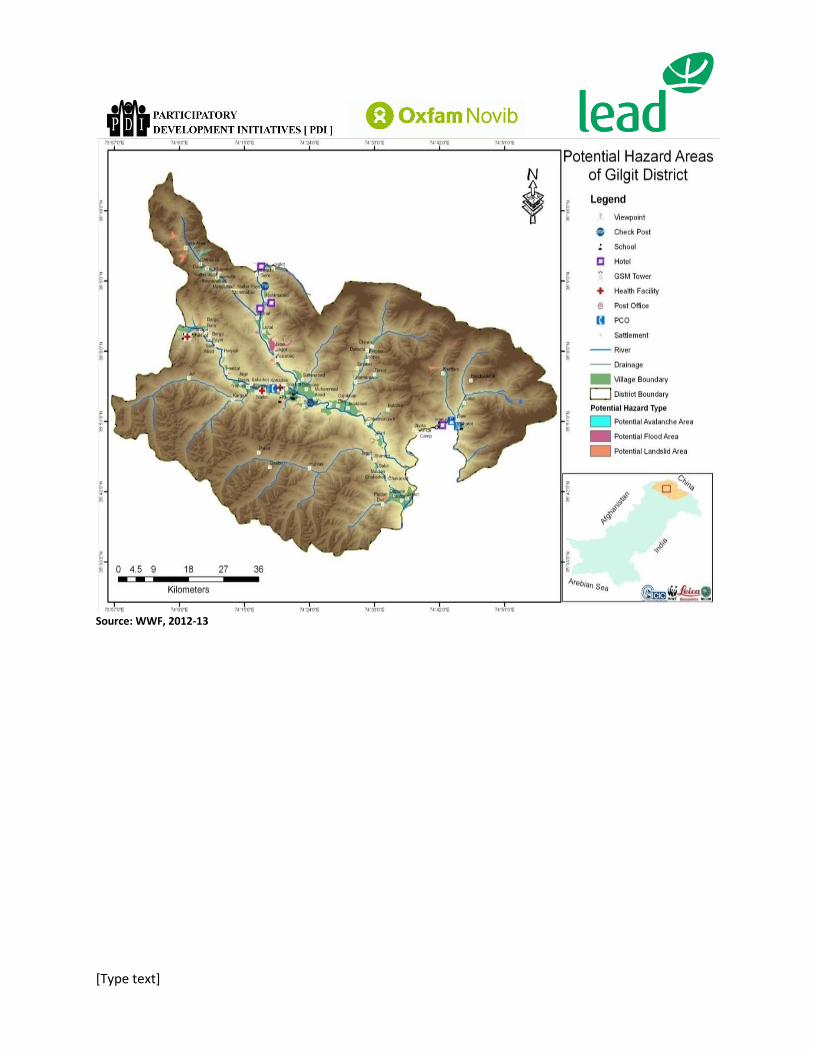
[Type text]
Source: WWF, 2012-13
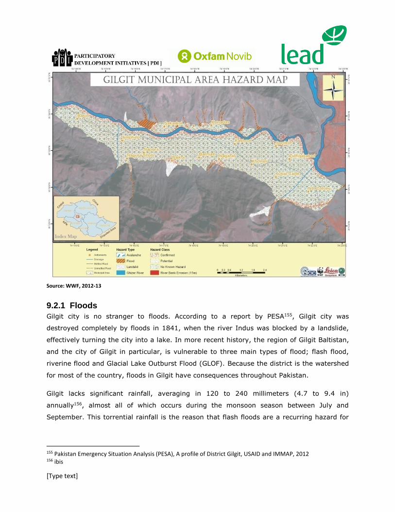
[Type text]
Source: WWF, 2012-13
9.2.1 Floods
Gilgit city is no stranger to floods. According to a report by PESA155, Gilgit city was
destroyed completely by floods in 1841, when the river Indus was blocked by a landslide,
effectively turning the city into a lake. In more recent history, the region of Gilgit Baltistan,
and the city of Gilgit in particular, is vulnerable to three main types of flood; flash flood,
riverine flood and Glacial Lake Outburst Flood (GLOF). Because the district is the watershed
for most of the country, floods in Gilgit have consequences throughout Pakistan.
Gilgit lacks significant rainfall, averaging in 120 to 240 millimeters (4.7 to 9.4 in)
annually156, almost all of which occurs during the monsoon season between July and
September. This torrential rainfall is the reason that flash floods are a recurring hazard for
155 Pakistan Emergency Situation Analysis (PESA), A profile of District Gilgit, USAID and IMMAP, 2012 156 ibis

[Type text]
Gilgit, which has insufficient drainage to absolve itself of excess storm water157. The city
also lacks a sewage system, so households commonly dispose of their solid waste in
excavated pits beneath their houses, not only putting their lives at further risk from floods
and earthquakes due to poor foundations, but also increasing the risk of contamination of
water from the waste. The main supply of piped water to households in Gilgit is from the
river, as well as for irrigation, therefore the contamination of this water has dire
consequences.
The River Gilgit flows through Gilgit City, as does the River Hunza. During the summer
months, due to snow melt higher up north, coupled with torrential monsoon rain, the risk of
riverine flood in the city is very high.
Glacial Lake Outburst Floods (GLOF) is a type of outburst flood occurring when water
dammed by a glacier is released due to melting of the ice, water pressure, erosion,
avalanches or earthquakes158. Most of the water utilized in Gilgit comes from glaciers, with
the northern regions of Pakistan having the largest glaciers outside the Polar Region. Gilgit
City is surrounded by these glaciers, following the age old pattern of settling where fresh
water is readily available. The risk of GLOF in the city, especially due to the impacts of
climate change such as increased precipitation and varying temperatures, is very high159.
9.2.2 Landslides and Avalanches
The southern slopes of Gilgit receive much rainfall, and therefore are abundant in trees such
as deodar, pine, poplar and willow160. The northern slopes do not receive as much rainfall
and therefore are naturally quite bare. Unfortunately, deforestation in the entire province of
Gilgit-Baltistan is rampant, due to increasing urbanization as well as the high price of wood
in markets, according to interviews. While deforestation can contribute to flooding, the main
threat posed is the danger of landslides and soil erosion161.
Another factor that adds to the danger of landslides and avalanches is that while mean
temperatures in Gilgit are always cold, sunlight is very strong and can cause rapidly melting
157Interview with Pakistan Red Crescent Society, Gilgit Baltistan. 158 UN Chronicle: Global Warming Triggers Glacial Lake Outburst Flood threat, accessed 12/11/2013 159 UNDP ‘ Reducing Risks and Vulnerabilities from Glacial Lake Outburst Floods’, inception report, 2011 160ibis 161UN Habitat Urban Observatory ‘Gilgit’ 2011
[Type text]
snow in the winter months, leading to avalanche162. This frequently disrupts travel routes to
and from the city, causing losses in trade.
9.2.3 Earthquakes and others
The seismic map of the region prepared by Pakistan Meteorological Department,
Geophysical Centre, Quetta, indicates that Gilgit lies in a very active seismic zone and the
seismic factor in this zone has been evaluated as “Zone of noticeable seismic danger”.
During the earthquake of 2005, losses of over 16.33 million rupees were reported in the GB
province163.
Gilgit is a unique city because it is one of the few cities in Pakistan with a non-sunni
majority. In recent times, due to political unrest throughout the country, Gilgit city centre
becomes strife with sectarian tension, particularly the two mosques of Shia and Sunni sects
that face each other.
9.3 Institutional Arrangements
9.3.1 Urban Planning
Gilgit city is administrated by the elected Town Nazim and the Naib Nazim. However the
administration of the city is under the Town Municipal Authority, headed by the Town
Municipal Officer. The various responsibilities of the TMO include solid waste management,
water supply, sanitation, civic law enforcement, maintenance of roads and infrastructure.
The Gilgit Development Authority is responsible for urban planning and reports to the Gilgit
Baltistan Planning and Development Department. The Gilgit Development Authority is a key
stakeholder in relation to disaster management since it is involved in preparing five year
and other provincial development plans.
Other than this, the various government line departments relating to food, agriculture,
irrigation etcetera are contributors to planning for the city.
9.3.2 Disaster Management
Like the other cities in Pakistan, the Gilgit District Disaster Management Authority is
responsible for DRR in the district, and reports to the Provincial Disaster Management
162 ibis 163 Pakistan Emergency Situation Analysis: A Profile of District Gilgit; 2012

[Type text]
Authority of Gilgit Baltistan. According to interviews with the Gilgit District Disaster
Management Authority, the following departments were consulted for the formulation of
Urban DRR plans: Gilgit Development Authority, GBPWD (Public Works Department), CDO
(Civil Defence Organization), Municipal Committee, P & D Department, Environment
Protection Agency, Education Department and District Administration(Collector & record
Keeper), Forestry Department, Health Dept. & Agriculture Department, and among the non-
government organizations IUCN, WWF, FOCUS (AKDN) & PRCS. All of these organizations
play an important role in disaster management in Gilgit city.
9.4 Stakeholder Analysis Although Gilgit has, for a variety of geographical and socio economic reasons, the potential
to become a hotbed for disasters and their impacts, it has managed to become an example
of best practice for urban DRR in Pakistan. This is not to say that disaster management in
the city is perfect; however, in terms of coordination between government line
departments, non-government organizations and the community, Gilgit city sets an example
that other cities would be hard pressed to follow. Although the DDMA of Gilgit has only
recently been set up, with most of the office materials being provided by non profits such as
the Agha Khan Development Network, the DDMA prepares Disaster Management Plan on an
annual basis. In addition, they also develop separate Contingency Plans (Monsoon rains etc)
which are prepared on-spot when needed. They do prioritize areas based on their
vulnerability to hazards164.
In the case of a disaster, their standard procedure starts with calls to 1122 (Rescue), PRCS
(Pakistan Red Crescent Society) and FOCUS and 150 volunteers in Gilgit District under
DDMA’s command, who assist in relief activities and coordination. They have also nominated
Counselor, Lumberdar and Imam as supervisors in certain areas where there are insufficient
volunteers available. The DDMA has demonstrated an exemplary inclusive approach to
disaster management, involving communities in their efforts as well as consulting a wide
range of government and non government organizations in their disaster planning
processes. Additionally, according to the interview with DDMA, trainings at a school level are
carried out from time to time to teach children about the basics of responding to and
164 Interviews with DDMA

[Type text]
preventing a disaster (although this is disputed by an interview with the education
department, who stated that the Punjab Curriculum is followed in Gilgit which has no
mention of disaster or training for disaster in it).
A key stakeholder for disaster relief in Gilgit is the Pakistan Red Crescent Society (PRCS).
The PRCS sees its role as more of a ‘post’ disaster one. Their activities e.g. training of
volunteers are based on providing emergency relief and recovery. The PRCS has 8000
volunteers throughout the province, of which 200 are at the Gilgit City level165. Their main
activities, according to the interviewer, are the provision of psycho social support, food and
non-food items and search and rescue trainings for volunteers and others. Although the
interviewee stated confidence in the direction disaster management was heading towards in
Gilgit city, a concern was stated about the lack of motivation of government officlas in local
administration towards achieving sustainable disaster management goals, for reasons that
may be political or a simple lack of interest. There was also some concern that the
Government has no system to check on duplication of project activities in the city and no
mechanism for coordination of NGOs is in place.
One of the biggest hazards to the city, according to PRCS is that there is no sewerage and
sanitation system and the common practice is the excavation of a deep pit below the
foundation of homes where the waste is disposed of. In case of a natural disaster like
earthquake, the probabilities of their survival are very low. Although building codes do exist,
according to the DDMA, only 4 buildings in all of Gilgit have applied these codes.
The Gilgit Education department holds the key to training and preparedness of young
children with reference to disaster. Currently, they are working with USAID under EDIP for
“School Safety Strategy” so as to prepare a document on safe school guidelines for the
people of these hazard-prone areas166. Although the department does carry out trainings for
school children, these are usually project based and depend on external sources of funding,
putting into question their sustainability.
The Environment Protection Agency for Gilgit Baltistan (GB-EPA)is an attached department
of the Ministry of Climate Change and has been established to provide for the protection,
165 Interview with PRCS 166 Interview with education department

[Type text]
conservation, rehabilitation and improvement of environment, for the prevention and
control of pollution, and promotion of sustainable development. Zoning and building codes,
environmental assessment, quality of raw material and inspection of construction site is
done by AD (Legal Enforcement)from their department in Gilgit167. Following interviews with
both the EPA and the Gilgit Development Authority, it was revealed that both are involved in
the development of master plans or land use plans, however, neither show evidence of
involving each other in developing these plans. As was the case with the projects in the
education department and the DDMA, a huge chunk of the funding for these initiatives
comes from external sources. In the long term, when the funding runs out, there has been
no effort to generate plans with sustainable sources of funding.
167 Interview with EPA

[Type text]
10 Conclusions, Lessons Learnt and Recommendations
10.1 Conclusions and Main Findings
Based on the interviews with key informants in various cities – including some documentation provided
by them - as well as the literature available through the Internet, some of the key findings that emerged
are the following. :
1. First and foremost, especially from the communities point of view, and in the
bigger cities – possibly with the exception of Gilgit in this set – there is very little
awareness of DRM. One of the reasons is that cities like Faisalabad and Rawalpindi
haven’t faced a major disaster in the recent past. For cities like Peshawar, Karachi
and to somewhat lesser extent, Quetta, the major problem is terrorism, at least in
the public perception. On the other hand, as stated earlier in this report (Urban
Situation of Pakistan), most of these cities have a high risk for potential disasters.
Added to this is the fact that apart from the staff at NDMA, and to a lesser extent,
the PDMAs, there is little or no awareness of HFA, even at the level of DDMAs.
While this may not be such a serious issue if all the necessary measures are
adopted, but that is also not the case. HFA provides an excellent, comprehensive,
and yet an easy to comprehend common-sense framework for understanding. For
our purpose, in particular, the Local Government Self Assessment Tool (LGSAT) is
especially suited for not only finding the status of preparedness for a city, but also
acts as a check list to guide what was needed to be done.
2. The second most important finding that starkly comes out through this study is
that we are still stuck in the emergency response paradigm. It is a reactive
management of disaster. Prevention and mitigation are not a priority. This will
require the inculcation of a whole new culture of disaster preparedness and
management, which needs to be built by working at different levels – from policy
and legal frameworks, to risk assessments and planning and percolating down to
the communities and educational institutions.
3. In general, operational mechanisms are ambiguous in terms of definition of roles
within and between organizations working in DRR-M. This generally results in a
lack of coordination between different government departments exacerbated by
poor information flow. This sometimes also results in overlapping responsibilities.
4. There is no focused attention on data and information management, barring
possibly PMD.

[Type text]
5. There is general awareness about Climate change and people and organizations
have started to incorporate measures as a response to this. However, a
coordinated mechanism does not exist and people in many cases are unable to
develop a response to the increasing impacts of climate change.
6. Multi-hazard vulnerability assessment has not been done for most of the cities
included in this study.
7. There is a lot of ambiguity about whether the Development Plan for the city exists
or not. This is especially true for smaller cities like Gilgit.
8. Funding for plans is mostly external and not assured through the government
budgets. For example, the Disaster Management Plans (DMP) by PDMAs have been
funded by UNDP through a one-time project.
9. While city district governments are responsible for the DRM at the local level, the
provincial governments have not devolved their powers yet and disseminate funds
without consultation with districts. As a result, very little, if any allocation, goes
under this head at the local level.
10. In Gilgit, meetings are held between the government and NGOs to plan for hazards
and upcoming disasters. In no other city that we studied this happens on a regular
basis. However, this is still not something based on sound institutional footing and
is critically dependent on the approachability of concerned government officials.
11. Cities are home to more manmade hazards than they are to natural ones, though
admittedly, a major natural hazard can cause a great calamity. For the moment,
people in cities like Peshawar, Karachi and Quetta are too concerned about
terrorism to think about other disasters.
12. Surprisingly, NDMA and PDMAs work in completely different spheres from one
another. What impact has the 18th amendment had on relationships between
different tiers of DMAs is still not very clear and a matter of debate if not confusion.
13. There is no clarity between donors, NDMA and PDMA about who the DMPs are
directed towards.
14. The line departments that are responsible for the repair of critical infrastructure are
not generally prepared to do so; neither are there plans to protect it in face of
major disasters.

[Type text]
15. In major cities that this study was conducted, building codes do exist despite being
obsolete However, even these are poorly enforced or not enforced at all in many
areas. It is mandatory for government buildings to be resistant to earthquakes
measuring 9 on the Richter scale but this is not applied to private building. As a
result only a few private buildings in Gilgit are earthquake resistant
16. While the Met Department is equipped with sophisticated equipment that forms the
basis of fairly reliable and accurate Early Warning System (EWS) with ‘Advisories’
and ‘Alerts’, there are no set mechanisms for broadcasting them to communities.
In Gilgit, however, there are plans to share the alerts on rainfall etc. in Urdu at the
local level by the international NGOs.
17. The Forest department in Gilgit is responsible for resilience, especially in terms of
protecting critical infrastructure. DMPs and ERTs need to be set up, despite being
prescribed by the plans they are not implemented.
18. Almost invariably, the DCO office has DDMUs and DDMA focal persons. In many
cases the Civil Defense focal points are now the DDMA focal points.
19. Interestingly, from experience in previous disasters, the most successful DM
mechanisms do not include formal institutions. The biggest assistance is from
volunteers.
20. 1122 department in Karachi has an inventory of logistics i.e. who has fire trucks,
ladders etc (which departments have them). This is a good example of cross
departmental coordination which generally doesn’t exist.
21. ERPs as a part of disaster management have not been developed at all. Disaster
response is always on an ad hoc basis.
22. In Gilgit there is evidence of informal training for rescue and evacuation. Hazard
watch groups are formed who get training from the PMD and their roles are defined
as well. If resources are not being allocated for proper disaster management, it is
unrealistic to expect resources to be allocated to soft interventions. Should focus
on macro interventions in our recommendations, followed by the micro ones.

[Type text]
10.2 Lessons Learnt
During the course of the discussions with the informants, some of the lessons learnt that emerged from
their own side are the following. They pertain to the post-disaster situation in the areas which recently
experienced disasters, especially the 2010 floods. Many of them were common to all the cities, while a
few of these were specific to a single city, most particularly Gilgit.
1. Strong coordination is required between all the government departments, stakeholders, NGOs
and iNGOs in disaster situations. (All)
2. The DDMA at the local level should provide NOC to the NGOs and other organizations for
intervention to overcome duplication and redundancy, as well as to prevent any potential law
and order situation. (All, but most particularly Gilgit).
3. A strong assessment team should be constituted with the help of personnel from reputed NGOs
so that transparent assessment may be ensured on ground. On the basis of fair assessment,
transparent relief and rehabilitation work can be carried out by the government for the genuine
affectees . (All)
4. The DDMA and other partner organizations need to have an early warning system in place to
minimize the losses of lives and movable properties. In this regard, Union Councils – when fully
functional - at the community level can play a vital role if properly managed. (All)
5. Voluntarism must be promoted by using the local scouts and volunteers because in an
emergency situation maximum manpower has to be mobilized. (All)
6. Every government department, specially the departments which cater to emergency services
or have major responsibilities during disaster situation, should have sufficient storage of fuel for
disaster emergencies, as in flood 2010 as all the organizations were facing shortage of fuel in the
because of the blockage of KKH. This greatly hampered relief and rehabilitation efforts during
the floods. (Gilgit)
7. Constitution of clusters during the disaster may be ensured to pool resources in an efficient
manner in the establishment of IDP Camps. (All)
8. The Health Office, Civil Supply Department and the Utility Stores Corporation must ensure
dumping of essential commodities and medicine to the far-flung area in case of blockade of road
access to the valleys due to floods. (Gilgit)
9. One of the areas which need to be strengthened is community based awareness sessions on
DRM activities and small level Community Based DRM (CBDRM) teams may be constituted to
deal with any immediate emergency situation at the community level. (All)

[Type text]
10.3 Recommendations:
10.3.1 HFA’s Ten Essential Areas
Some of our recommendations follow directly from the findings listed above, but before we
list them, we would like to focus on HFA’s ten essential areas and the attendant
recommendations – one for each of them. They form the basis for international best
practices to be relevant for local governments. Listed are these recommendations which
underpin HFA’s Local Government Self Assessment Tool (LGSAT) and can be applied with
little change to the cities in Pakistan.
HFA Priority 1 – Make Disaster Risk Reduction a Priority
1. Have competent and accountable urban and local governance in place, including
mechanisms for disaster risk reduction, based on a participatory dialogue between city
governments and civil society to identify risks, and apply risk reduction and preparedness
2. Have an assigned city budget for disaster risk reduction, with provisions for finance and
technical cooperation enabling low-income families to reduce risks in their housing and environment, and to strengthen resilience through effective social safety nets
3. Have proactive policies and strategies to provide safe land for low-income citizens
HFA Priority 2 – Know the Risks and Take Action
4. Have a comprehensive risk assessment constantly updated and used as basis for
urban development plans and early warning system, and easily available and understood by
the public
HFA Priority 3 – Build Understanding and Awareness
5. Have education programmes on disaster risk reduction in place in schools and local
communities
HFA Priority 4 – Reduce Risk
6. Invest to reduce the deficit of risk-reducing infrastructure, such as flood drainage in
high risk areas, and put in place management systems with local communities to ensure their maintenance.
7. Make risk compliant building regulations and land use planning norms appropriate
to the needs and possibilities of low income citizens and apply them as an instrument to improve the safety of the built environment
8. Have all schools and health facilities and other critical facilities assessed and
upgraded as necessary to withstand major hazards, and develop plans for recovering and
protecting heritage buildings and sites

[Type text]
9. Have plans and regulations in place to protect ecosystems and natural buffers to
mitigate floods, storm surges and other hazards, and ensure that climate change
adaptation initiatives builds on risk reduction practices
HFA Priority 5 – Be Prepared and Ready to Act
10. Have early warning and emergency management capacities in place, with locally
owned preparedness plans known and regular public drills
10.3.2 Other Recommendations
1. Media need to be involved in raising awareness not only about disasters but disaster risk
reduction and management as well. May be a special communication project – underpinned by a media campaign – needs to be designed to create the necessary awareness and sensitization about this very important aspect of urban living under the cloud of increasing frequency of extreme events induced by climate change.
2. With the revival of local bodies, including city district governments about to be elected in the coming months in all the provinces, there is an excellent window of opportunity for working with them, both at the level of awareness and sensitization as well as training and capacity building to seed a process of institutional DRM at the local/city level.
3. The Government has to provide dedicated staff and resources for urban risk management at the Tehsil (sub-district) level, especially for coordination and information management.
4. In order to do a meaningful DRM, all the necessary data should be collected, collated
and analyzed periodically. This would include a whole range of data from an
inventory of critical infrastructure to rescue instruments and relief supplies; and
multiple risk assessments to mitigation measures – if undertaken – that need to be
tracked for progress.
5. Multi-hazard vulnerability assessment and mapping should be carried out immediately. The assessment and mapping should be done together with the local government and local stakeholders so as to develop local tools for mitigation and emergency response.
6. DRR plans for each city should be prepared and need to be integrated with other
relevant plans, like land use and development plans. At the moment such integration doesn’t exist at all.

[Type text]
7. Safety assessment of educational and health facilities should be carried out immediately
and where required the unsafe buildings should be demolished or repaired.
8. Regular updating of safety regulations including building codes and implementation be forced by concerned departments. Commercial licenses be awarded on fulfillment of safety measures.
9. Building codes need to be revised in the light of latest standards that have been
developed with better protection against hazards, especially earthquakes. These
standards have been adopted and are followed in other parts of the world. But more
importantly, whatever in the form of such codes that exist or have to be revised,
need to be enforced.
10. Insurance and financial services for risk transfer need to be developed to facilitate urban risk management.
11. Community trainings are being carried out in some places – especially in Gilgit - but
there needs to be a volunteer citizens' group that should be trained for preparedness, and in times of emergency, to volunteer for emergency services. Previously Pakistan had Civil Defense Service and active Boy and Girl scouts but in the recent times these voluntary public service groups have dwindled to near extinction.
12. Urban risk management should be immediately linked with urban management and project planning. More specifically, and in concrete terms, PC-I should have a note related to DRR.
13. Key elements of DRR-M should be incorporated in school curricula. Given that it takes time to do so (design and approval of the curriculum, development of new text books and their publication) work on it should start on an urgent basis.
14. The Meteorological Department, which is almost the sole custodian and manager of Early Warning Systems (EWS,) needs to be strengthened for EWS to be more effective.
15. Apart from these soft components, investment needs to be made on disaster resilient infrastructure like:
Hospitals with necessary facilities and life saving equipment;
Well equipped Search & Rescue facility;

[Type text]
Provision of street lights and WASH facilities to residents;
Emergency Coordination Centre with necessary equipment and facilities; and Repair, and if possible, retrofitting of critical buildings.
11 Annexures
11.1 Annex 1: HFA Core Indicators and their Scope of Applicability for Pakistan
Priority for Action 1: Ensure that disaster risk reduction is a national and a local priority with a strong institutional basis for implementation.
Scope (of Applicability)
Core indicator 1.1 National policy and legal framework for disaster risk reduction exists with decentralized responsibilities and capacities at all levels.
National (but with decentralized responsibilities and capacities)
Core indicator 1.2 Dedicated and adequate resources are available to implement disaster risk reduction plans and activities at all administrative levels
National/Provincial/Local
Core indicator 1.3 Community Participation and decentralisation is ensured through the delegation of authority and resources to local levels
Locali
Core indicator 1.4 A national multi sectoral platform for disaster risk reduction is functioning.
National
Priority for action 2: Identify, assess and monitor disaster risks and enhance early warning
Core indicator 2.1 National and local risk assessments based on hazard data and
National/Provincial/Local

[Type text]
vulnerability information are available and include risk assessments for key sectors.
Core indicator 2.2 Systems are in place to monitor, archive and disseminate data on key hazards and vulnerabilities
National/Provincial/Local
Core indicator 2.3 Early warning systems are in place for all major hazards, with outreach to communities.
Local
Core indicator 2.4 National and local risk assessments take account of regional / trans boundary risks, with a view to regional cooperation on risk reduction.
International
Priority for action 3
Use knowledge, innovation and education to build a culture of safety and resilience at all levels
Core indicator 3.1 Relevant information on disasters is available and accessible at all levels, to all stakeholders (through networks, development of information sharing systems etc)
National/ProvinciaL/local
Core indicator 3.2 School curricula , education material and relevant trainings include disaster risk reduction and recovery concepts and practices.
Provincial
Core indicator 3.3 Research methods and tools for multi-risk assessments and cost benefit analysis are developed and strenghtened.
National/Provincial/Local
Core indicator 3.4 Countrywide public awareness strategy exists to stimulate a culture of disaster resilience, with outreach to urban and rural communities
National/Provincial/Local
Priority for action 4 Reduce the underlying risk factors
Core indicator 4.1 Disaster risk reduction is an integral objective of environment related policies and plans, including for land use natural resource management and adaptation to climate change.
Provincial/Local
Core indicator 4.2 Social development policies and plans are being implemented to reduce the vulnerability of populations most at risk.
Provincial/Local
Core indicator 4.3 Economic and productive sectoral policies National

[Type text]
and plans have been implemented to reduce the vulnerability of economic activities
Core indicator 4.4 Planning and management of human settlements incorporate disaster risk reduction elements, including enforcement of building codes.
Provincial/Local
Core indicator 4.5 Disaster risk reduction measures are integrated into post disaster recovery and rehabilitation processes
Provincial/Local
Core indicator 4.6 Procedures are in place to assess the disaster risk impacts of major development projects, especially infrastructure.
Provincial
Priority for action 5 Strengthen disaster preparedness for effective response at all levels
Core indicator 5.1 Strong policy, technical and institutional capacities and mechanisms for disaster risk management, with a disaster risk reduction perspective are in place.
National
Core indicator 5.2 Disaster preparedness plans and contingency plans are in place at all administrative levels, and regular training drills and rehearsals are held to test and develop disaster response programmes.
National/Provincial/Local
Core indicator 5.3 Financial reserves and contingency mechanisms are in place to support effective response and recovery when required.
National/Provincial/Local
Core indicator 5.4 Procedures are in place to exchange relevant information during hazard events and disasters, and to undertake post-event reviews
National/Provincial/Local
11.2 Annex 2: Questionnaire’s for City Stakeholders.
Priority for action 1: Ensure that disaster risk reduction is a national and a local priority with a strong institutional basis for implementation.

[Type text]
1. Are there provincial/city level DRR plans?
2. If no city level plans, are there any district level plans?
3. If yes, who was consulted in the formation of these plans?
4. Which departments are involved in the development of these plans (for urban cities)?
5. Is there a budget for the implementation of DRR plans?

[Type text]
6. What percentage of the total budget is allocated to DRR activities (provincial/district/city)?
7. Are there any non-governmental (business, civil society) streams of funding/support for DRR?
8. Do the budgets filter down to the local level and is there a delegation of authority to the local level?
9. How is community participation ensured (if at all) in DRR activities/these plans?
Priority for action 2: Identify, assess and monitor disaster risks and enhance early warning
10. Are risk assessments conducted?

[Type text]
11. What sector(s) is assessed during these risk assessments?
12. If yes, who conducts them?
13. Are these risk assessments used to inform plans and policies?
14. What sources of information are used?

[Type text]
15. Based on these risk assessments, are areas prioritized for interventions according to their vulnerability? On what basis are these areas prioritized?
16. Do the disaster management plans, if any, include communication and dissemination plans?
17. How is the authenticity of data collected verified?
18. Does an early warning system exist?
19. What hazards does it cover?

[Type text]
20. How is it disseminated to the communities?
Priority for action 3: Use knowledge, innovation and education to build a culture of safety and resilience at all levels
21. How do citizens know about disaster related information (dangers associated with various disasters, their frequency etc)?
22. Is there an information sharing mechanism between departments about disasters?
23. Is there a central repository of information relating to potential hazards that is easily accessible?

[Type text]
24. Have DRR concerns been integrated into school curricula?
25. If not, are there any plans to do so?
26. Are we conducting multi-risk assessments?
27. Are there tools to do so?
28. How often are these assessments carried out?
[Type text]
29. What steps have been taken to sensitize citizens regarding disaster resilience?
30. Have any campaigns for promoting public awareness of potential disasters been carried out?
Priority for action 4: Reduce the underlying risk factors
31. Do environment policies and plans take into account DRR?
32. Are DRR concerns linked to climate change? Have we tried to look at DRR through the lens of climate change impacts?
33. Do the EIA checklists specifically list DRR considerations?

[Type text]
34. Do development policies and plans take into account vulnerability to disaster of their target areas?
35. Is there a specific focus for the poorest sections of the population in terms of their vulnerability to disaster?
36. What specific DRR/DRM measures are taken for planning and management of human settlements?
37. Are there any building codes against earthquakes and floods/other disasters?
Priority for action 5: Strengthen disaster preparedness for effective response at all levels
38. Are post disaster developments inclusive of prospective DRM elements?

[Type text]
39. Are gender considerations taken into account during relief and recovery phase?

[Type text]
11.3 Annex 3: Information Checklist for Cities
Hazard Mapping, Risk Assessments and DRR-M Planning
1. What important hazards does the city face?
2. Has a multiple hazard mapping been carried out?
3. Has there been a multiple risk assessment (MRA) for the city? If it is only for a single hazard,
which one is it for?
4. Has this risk assessment been fed into a DRR/M Plan? So is there a DRR/M plan for the city?
5. What was the process followed in chalking out this Plan? (Needs explanation)
6. Which agencies and institutions were consulted to make this Plan?
7. Have CSOs and community representatives also involved in this process? If not, how is it
communicated to them ? (please don’t confuse it with an early warning system)
8. How is this Plan funded? Are there specific budget allocations?
9. What percentage of the city/district budget is allocated to the Plan?
10. What’s the frequency of risk assessments?
Some Longer Term Issues in Disaster Reduction and Management
11. Are there zoning laws for the city?
12. To what level (of effectiveness) are they enforced? (Needs explanation)
13. Which agency oversees the compliance of these laws?
14. Are there building codes, and if so, for what disasters? (like earthquake, fire, flood, storm etc.)
15. If so, how effectively are they enforced? (Needs explanation)
16. Does the city have a drainage system?
17. Are there storm drains for flooding and heavy rainfall emergencies?
18. What if any measures are there to handle epidemics?
19. Are there any measures in place for food and water security in case of extended droughts,
disruption of food or water supplies?
20. What kind of fire safety system exists for the city?
21. Are there any special measures to handle large scale casualties, say from accidents and terrorist
attacks?
22. Are there areas in the city that are especially vulnerable to disasters? (Needs explanation – what
kind of areas and to what hazards, are they inhabited by lower income groups etc.?)
23. Is there a specific focus for the poorest sections of the population in terms of their vulnerability
to disaster?
24. Are DRR concerns linked to climate change? Has there been an attempt to look at DRR through
the lens of climate change impacts?
25. What specific DRR/DRM measures are taken for planning and management of human
settlements?

[Type text]
26. Is there a development plan for the city? If so, what’s the time period (for the plan)?
27. Does the development plan have a DRR/M component?
28. If so, have projects been conceived under it or budget allocated?
29. What percentage of the total budget does the above cover?
Early Warning and Disaster Preparation
30. Is there an early warning system against disasters – more specifically for floods, cyclones, high
velocity winds and other disruptive weather patterns?
31. How does it – the early warning system – work? (systems, procedures etc.)
32. Have children or school students been sensitized against potential hazards?
33. Have there been drills for disaster preparation and evacuation, especially in schools?
Post Disaster Rescue, Relief, Recovery and Reconstruction
34. Are post disaster developments inclusive of prospective DRM elements?
35. Are gender considerations taken into account during relief and recovery phase? (needs some
explanation)
i In the context of Pakistan ‘local’ encapsulates district and sub-district (tehsil and union
council) levels