A. Schumacher, CIRA/Colorado State University NHC Points of Contact: M. DeMaria, D. Brown, M....
18
Upgrades to the operational Monte Carlo wind speed probability program A. Schumacher, CIRA/Colorado State University NHC Points of Contact: M. DeMaria, D. Brown, M. Brennan, R. Berg, C. Ogden, C. Mattocks, and C. Landsea Joint Hurricane Testbed Update Tropical Cyclone Research Forum/69th IHC, 2-5 March 2015 Presenter email: [email protected]
-
Upload
arron-wiggins -
Category
Documents
-
view
215 -
download
1
Transcript of A. Schumacher, CIRA/Colorado State University NHC Points of Contact: M. DeMaria, D. Brown, M....
Upgrades to the operational Monte Carlo wind speed
probability program
A. Schumacher, CIRA/Colorado State UniversityNHC Points of Contact: M. DeMaria, D. Brown, M. Brennan, R. Berg, C. Ogden, C.
Mattocks, and C. LandseaJ o i n t H u r r i ca n e Te s t b e d U p d a te
Tro p i ca l C yc l o n e Re s e a rc h F o r u m / 6 9 t h I H C , 2 - 5 M a rc h 2 0 1 5P r e s e n te r e m a i l : a n d r e a . s c h u m a c h e r @ co l o s ta te . e d u
Tropical Cyclone Research Forum/69th IHC 2
Outline
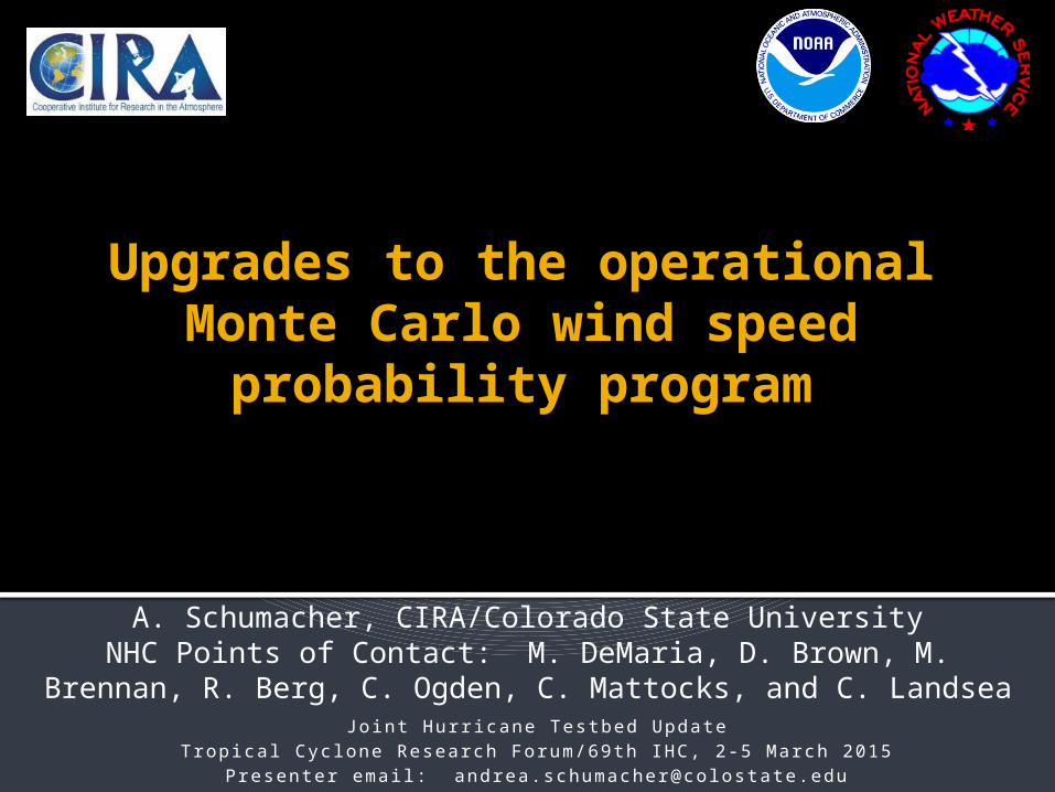
Proposed 7 improvements / updates to MC model that reflect feedback from NHC forecasters Improve time interpolation scheme Apply bias-correction to model track error statistics Apply bias-correction to radii-CLIPER model when official radii forecasts exist Integrated GPCE guidance for NHC forecasters Arrival and departure estimates of 34, 50, and 64-kt winds Extend MC model to 7 days (April-May 2015) Software upgrade (May-June 2015)
Impacts on MC model performance Plans for 2015 season
Tropical Cyclone Research Forum/69th IHC 3
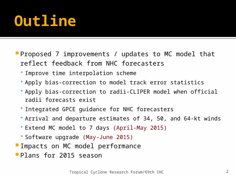
1. Improve time interpolation scheme
Linear interpolation between time steps introduces track errors Slight eastward bias for
recurving TCs On order of ±1-5%
Replaced with spline fit to generate smoother, more realistic tracks
Spline interpolation option added for official forecast forecast realizations
Implemented in 2015 operational MC model
*Images courtesy of Casey Ogden, NHC
Earl on 31 Aug 2010 at 0Z – using linear interpolation (left) vs. spline (right)
Tropical Cyclone Research Forum/69th IHC 4
2. Bias correction to error statistics
Error statistics used to develop wind speed probabilities are slightly different than the official NHC errors Include non-tropical systems (extratropical, post-tropical)
Updated MC model error statistics to match NHC errors statistics
Benefits Improve consistency between NHC uncertainty products
In future, can create cone that can increase and decrease based on GPCE parameter
Serial correlation still introduces a small bias
Tropical Cyclone Research Forum/69th IHC 5
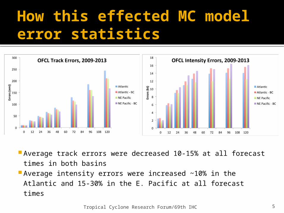
How this effected MC model error statistics
Average track errors were decreased 10-15% at all forecast times in both basins
Average intensity errors were increased ~10% in the Atlantic and 15-30% in the E. Pacific at all forecast times
Tropical Cyclone Research Forum/69th IHC 6
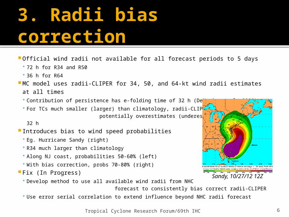
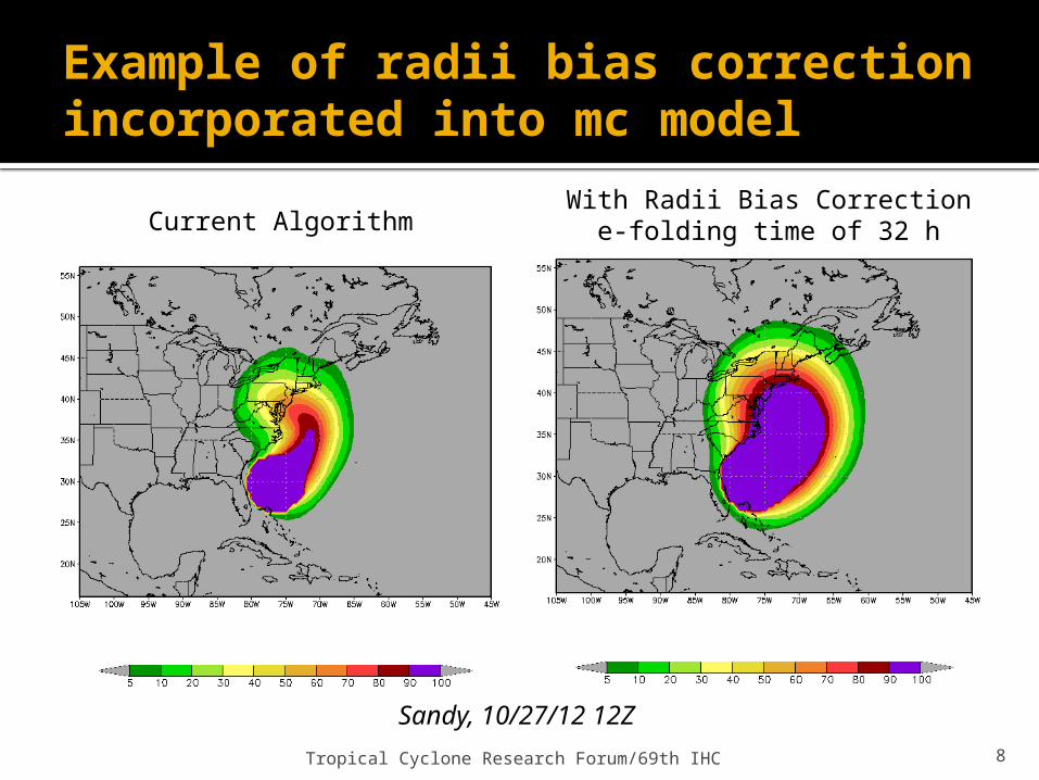
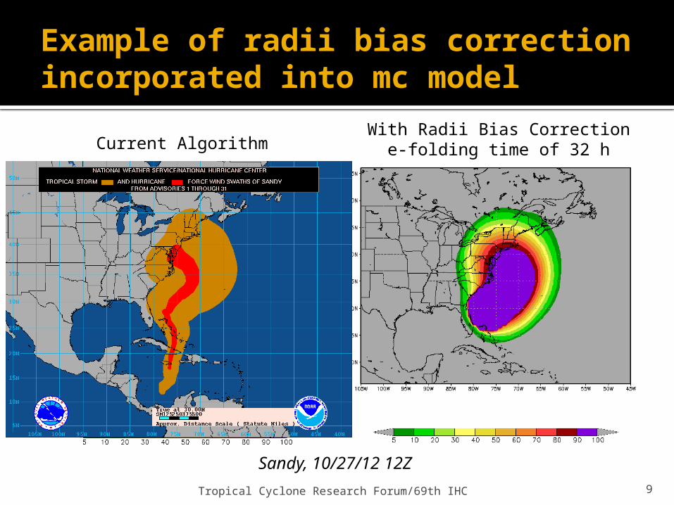
3. Radii bias correction
Official wind radii not available for all forecast periods to 5 days 72 h for R34 and R50 36 h for R64
MC model uses radii-CLIPER for 34, 50, and 64-kt wind radii estimates at all times Contribution of persistence has e-folding time of 32 h (DeMaria et al. 2009) For TCs much smaller (larger) than climatology, radii-CLIPER potentially
overestimates (underestimates) radii for t > 32 h Introduces bias to wind speed probabilities
Eg. Hurricane Sandy (right) R34 much larger than climatology Along NJ coast, probabilities 50-60% (left) With bias correction, probs 70-80% (right)
Fix (In Progress) Develop method to use all available wind radii from NHC forecast to
consistently bias correct radii-CLIPER Use error serial correlation to extend influence beyond NHC radii forecast
Sandy, 10/27/12 12Z
Tropical Cyclone Research Forum/69th IHC 7
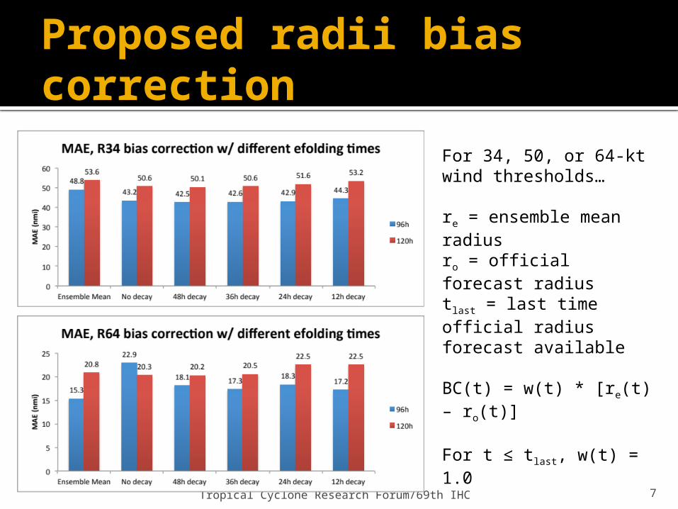
Proposed radii bias correction
For 34, 50, or 64-kt wind thresholds…
re = ensemble mean radiusro = official forecast radiustlast = last time official radius forecast available
BC(t) = w(t) * [re(t) – ro(t)]
For t ≤ tlast, w(t) = 1.0
For t > tlast, w(t) = e-[(t-tlast)/D]
where D is the e-folding time
Tropical Cyclone Research Forum/69th IHC 8
Example of radii bias correction incorporated into mc model
Current AlgorithmWith Radii Bias Correction
e-folding time of 32 h
Sandy, 10/27/12 12Z
Tropical Cyclone Research Forum/69th IHC 9
Example of radii bias correction incorporated into mc model
Current AlgorithmWith Radii Bias Correction
e-folding time of 32 h
Sandy, 10/27/12 12Z
Tropical Cyclone Research Forum/69th IHC 10
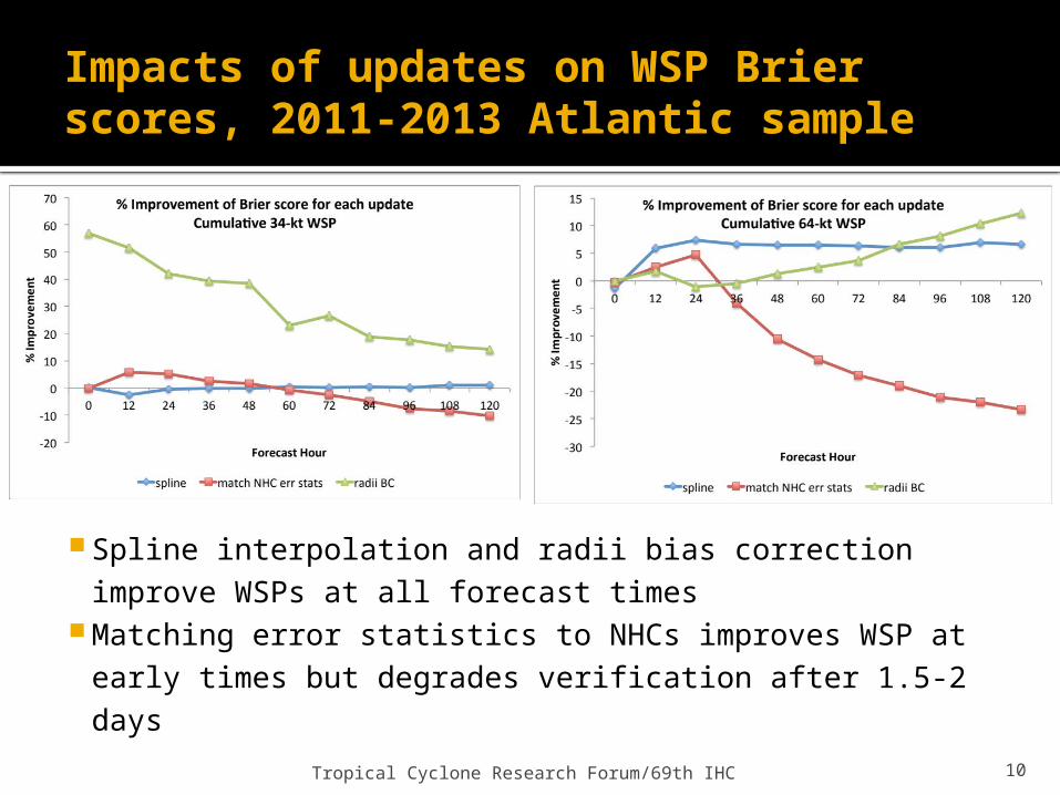
Impacts of updates on WSP Brier scores, 2011-2013 Atlantic sample
Spline interpolation and radii bias correction improve WSPs at all forecast times
Matching error statistics to NHCs improves WSP at early times but degrades verification after 1.5-2 days
Tropical Cyclone Research Forum/69th IHC 11
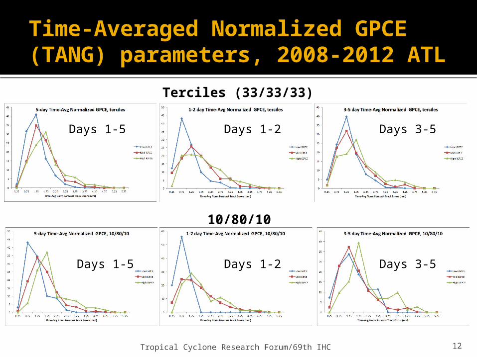
4. Time-Integrated GPCE Guidance
DeMaria et al. 2013 showed relationship between GPCE terciles and track forecast error distribution Low (high) GPCE values correspond to less (more) spread Motivated use of GPCE parameter to modify MC model
Developed time-integrated measure of GPCE information used in MC model Provide forecasters 3-category measure of confidence for entire track forecast
(low/med/high) Time-averaged normalization
Normalize all GPCE values and forecast error by their standard deviation at that forecast time
Then, average over selected range of time (here 0-5 days, 0-2 days, and 3-5 days) Examined 2008-2012 Atlantic cases
Both forecast errors and GPCE must be available to 5 days (N=718)
Tropical Cyclone Research Forum/69th IHC 12
Time-Averaged Normalized GPCE (TANG) parameters, 2008-2012 ATL
Terciles (33/33/33)
10/80/10
Days 1-5
Days 1-5
Days 1-2
Days 1-2
Days 3-5
Days 3-5

Tropical Cyclone Research Forum/69th IHC 13
TANG classification examplesLow GPCE Days 1-2, High GPCE Days 3-5 TANG 1-2day TANG 3-5day TANG 0-5day
Fcst Hr 12 24 36 48 60 72 84 96 108 120 10/80/10
33/33/33
10/80/10
33/33/33
10/80/10
33/33/33
AL172012 101512 33 54 69 86 130 174 240 306 382 458 M L M H M H
AL182011 102606 23 42 66 97 154 211 333 455 607 759 L L H H H H
AL162011 093006 26 46 71 100 148.5 197 279 361 427.5 494 M L H H M H
AL062010 082706 21 42 65 100 137.5 175 226 277 328 379 L L M H M M
High GPCE Days 1-2, Low GPCE Days 3-5 TANG 1-2day TANG 3-5day TANG 0-5day
Fcst Hr 12 24 36 48 60 72 84 96 108 12010/80/
1033/33/
3310/80/
1033/33/
3310/80/
1033/33/
33AL032012
062100 41 66 122 154 153 152 177.5 203 229.5 256 H H M L M HAL162011
092112 42 70 96 122 127.5 133 162.5 192 230.5 269 M H M L M MAL052011
080706 52 97 149 165 152.5 140 166.5 193 216 239 H H M L M HAL062010
082118 63 112 146 168 160 152 168 184 189 194 H H M L M H
Tropical Cyclone Research Forum/69th IHC 14
5. Time of wind arrival / departure estimates
Realizations created by MC model can be used to provide estimates of the time of arrival & departure of 34, 50, and 64-kt winds for various threshold (e.g., 10th, 50th, 90th, 95th percentiles)
TOA/TOD estimates currently available in Hurricane Landfall Probability Application (HuLPA), with limitations Computed at single breakpoints Accessible via GUI after MC model has run (inefficient)
Numerous uses for TOAs/TODs Emergency managers (e.g., road closures, evacuation timing) Utilities (e.g., response planning)
NHC POCs (e.g., M. DeMaria, C. Ogden, R. Berg) have taken the lead on developing and refining this upgrade
Tropical Cyclone Research Forum/69th IHC 15
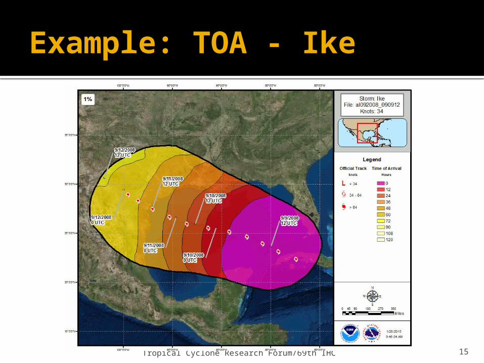
Example: TOA - Ike
Tropical Cyclone Research Forum/69th IHC 16
Remaining updates
#6 (April-May 2015) – Extend wind speed probabilities to 7 days Create developmental dataset of 7-day forecasts▪ 2012, 2013, 2014 – NHC forecasts▪ Prior to 2012 – GFS tracks and trajectory-CLIPER intensity
#7 (May-June 2015) – Software update Consolidate code and scripts for seasonal updates
Tropical Cyclone Research Forum/69th IHC 17
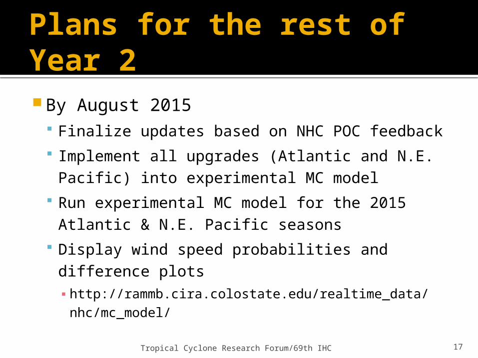
Plans for the rest of Year 2
By August 2015 Finalize updates based on NHC POC feedback Implement all upgrades (Atlantic and N.E. Pacific) into
experimental MC model Run experimental MC model for the 2015 Atlantic &
N.E. Pacific seasons Display wind speed probabilities and difference plots ▪ http://rammb.cira.colostate.edu/realtime_data/nhc/
mc_model/
Tropical Cyclone Research Forum/69th IHC 18
Thank you! Questions?
References: Goerss, J. S., 2007: Prediction of consensus tropical cyclone track forecast
error. Mon. Wea. Rev., 135, 1985–1993.
Knaff, J. A., C. R. Sampson, M. DeMaria, T. P. Marchok, J. M. Gross, and C. J. McAdie, 2007: Statistical tropical cyclone wind radii prediction using climatology and persistence. Wea. Forecasting, 22, 781–791.
DeMaria, M., J.A. Knaff, R.D. Knabb, C.A. Lauer, C.R. Sampson, and R.T. DeMaria, 2009: A New Method for Estimating Tropical Cyclone Wind Speed Probabilities. Wea. Forecasting, 24, 1573–1591.
DeMaria.M., J.A. Knaff, M.J. Brennan, D. Brown, R.D. Knabb, R.T DeMaria, A. Schumacher, C.A. Lauer, D.P. Roberts, C.R. Sampson, P. Santos, D. Sharp, and K.A. Winters, 2013: Improvements to the operational tropical cyclone wind speed probability model. Submitted to Wea. Forecasting.