A remote sensing observatory for hydrologic sciences: A ... · A remote sensing observatory for...
13
A remote sensing observatory for hydrologic sciences: A genesis for scaling to continental hydrology Witold F. Krajewski, 1 Martha C. Anderson, 2 William E. Eichinger, 1 Dara Entekhabi, 3 Brian K. Hornbuckle, 4 Paul R. Houser, 5 Gabriel G. Katul, 6 William P. Kustas, 2 John M. Norman, 7 Christa Peters-Lidard, 8 and Eric F. Wood 9 Received 18 July 2005; revised 24 February 2006; accepted 4 May 2006; published 13 July 2006. [1] Uncertainties in assessing the effects of global-scale perturbations on the climate system arise primarily from an inadequate understanding of the hydrological cycle: on land, in oceans, and in the atmosphere and biosphere. Because of this uncertainty, almost all science-based initiatives have expressed the need for continued advances in global observations and modeling of the Earth system. It is in this spirit that we advocate establishing a hydrologic remote sensing observatory (RSO) to advance sensing technologies and their use in scientific inquiry into hydrologic processes. There are two fundamental reasons why establishing such a RSO is timely. The first is operational: Developing assimilation techniques to estimate unobserved fluxes and uncertainties in hydrologic forecasts has sufficiently matured to take advantage of computing facilities and detailed hydrologic observations shaped by the RSO. The second is scientific: This RSO will permit us to refine knowledge from physical and hydrologic models that can then be converted to local and global strategies for water resources management and ecosystem health evaluation. The authors outline the conceptual design, scope, and functionality of a RSO and present four examples to illustrate how the hydrologic community can take advantage of such facility. Citation: Krajewski, W. F., et al. (2006), A remote sensing observatory for hydrologic sciences: A genesis for scaling to continental hydrology, Water Resour. Res., 42, W07301, doi:10.1029/2005WR004435. 1. Introduction and Problem Statement [2] The complexity and heterogeneity of hydrologic interactions exists over a wide range of scales in space and time. It is also widely accepted that remote sensing, broadly defined as a collection of noncontact observational methods, offers the potential to capture some of the intri- cacies of these spatial and temporal processes. Yet, hydrol- ogy today finds itself in a paradigm lock with respect to understanding the controls on hydrologic fluxes and states and how these controls vary spatially and temporally with scale and how the land surface and subsurface couples with the overlying atmospheric boundary layer. The current paradigm is that a given hydrological scale, whether it be a ‘‘Darcian,’’ catchment, or the atmospheric boundary layer, the nonlinear dynamics describing water transport is pre- sented as a function of the state at that resolved scale, and all finer scale (or faster) processes are treated as subgrid. Much coarser scale processes are generally assumed to be either sufficiently slow, or their effects are prescribed as forcing. It is clear then that the high dimensionality of hydrologic processes prohibits us from tracking cross-scale interactions across space and time. This knowledge gap invites the use of multiscale data offered by remote sensing platforms; however, the remote sensing algorithms are insufficiently developed for these complex processes to provide the spatial observations necessary for exploring cross-scale information flow. [3] To break this lock we propose establishing an inte- grated remote sensing observatory (RSO) where research across the spectrum of hydrologic remote sensing can be integrated with hydrologic processes occurring at scales of less than a meter to thousands of kilometers. Historically, remote sensing products have been evaluated through short- term activities focusing on a single geophysical variable. We question this approach, and instead offer a vision of a community observatory where fundamental research on the estimation of water-energy-ecosystem variables can be carried out in an integrated manner across complex land- scapes. The observatory offers the potential of improved predictions from remote sensing measurements for other 1 IIHR– Hydroscience and Engineering, University of Iowa, Iowa City, Iowa, USA. 2 Hydrology and Remote Sensing Laboratory, ARS, USDA, Beltsville, Maryland, USA. 3 Department of Civil and Environmental Engineering, Massachusetts Institute of Technology, Cambridge, Massachusetts, USA. 4 Department of Agronomy, Iowa State University, Ames, Iowa, USA. 5 Center for Research on Environment and Water, George Mason University, Calverton, Maryland, USA. 6 Nicholas School of the Environment and Earth Sciences, Duke University, Durham, North Carolina, USA. 7 Department of Soil Science, University of Wisconsin, Madison, Wisconsin, USA. 8 NASA Goddard Space Flight Center, Greenbelt, Maryland, USA. 9 Department of Civil and Environmental Engineering, Princeton University, Princeton, New Jersey, USA. Copyright 2006 by the American Geophysical Union. 0043-1397/06/2005WR004435$09.00 W07301 WATER RESOURCES RESEARCH, VOL. 42, W07301, doi:10.1029/2005WR004435, 2006 Click Here for Full Articl e 1 of 13
Transcript of A remote sensing observatory for hydrologic sciences: A ... · A remote sensing observatory for...

A remote sensing observatory for hydrologic sciences:
A genesis for scaling to continental hydrology
Witold F. Krajewski,1 Martha C. Anderson,2 William E. Eichinger,1 Dara Entekhabi,3
Brian K. Hornbuckle,4 Paul R. Houser,5 Gabriel G. Katul,6 William P. Kustas,2
John M. Norman,7 Christa Peters-Lidard,8 and Eric F. Wood9
Received 18 July 2005; revised 24 February 2006; accepted 4 May 2006; published 13 July 2006.
[1] Uncertainties in assessing the effects of global-scale perturbations on the climatesystem arise primarily from an inadequate understanding of the hydrological cycle: onland, in oceans, and in the atmosphere and biosphere. Because of this uncertainty, almostall science-based initiatives have expressed the need for continued advances in globalobservations and modeling of the Earth system. It is in this spirit that we advocateestablishing a hydrologic remote sensing observatory (RSO) to advance sensingtechnologies and their use in scientific inquiry into hydrologic processes. There are twofundamental reasons why establishing such a RSO is timely. The first is operational:Developing assimilation techniques to estimate unobserved fluxes and uncertainties inhydrologic forecasts has sufficiently matured to take advantage of computing facilities anddetailed hydrologic observations shaped by the RSO. The second is scientific: This RSOwill permit us to refine knowledge from physical and hydrologic models that can thenbe converted to local and global strategies for water resources management and ecosystemhealth evaluation. The authors outline the conceptual design, scope, and functionality of aRSO and present four examples to illustrate how the hydrologic community can takeadvantage of such facility.
Citation: Krajewski, W. F., et al. (2006), A remote sensing observatory for hydrologic sciences: A genesis for scaling to continental
hydrology, Water Resour. Res., 42, W07301, doi:10.1029/2005WR004435.
1. Introduction and Problem Statement
[2] The complexity and heterogeneity of hydrologicinteractions exists over a wide range of scales in spaceand time. It is also widely accepted that remote sensing,broadly defined as a collection of noncontact observationalmethods, offers the potential to capture some of the intri-cacies of these spatial and temporal processes. Yet, hydrol-ogy today finds itself in a paradigm lock with respect tounderstanding the controls on hydrologic fluxes and statesand how these controls vary spatially and temporally withscale and how the land surface and subsurface couples with
the overlying atmospheric boundary layer. The currentparadigm is that a given hydrological scale, whether it bea ‘‘Darcian,’’ catchment, or the atmospheric boundary layer,the nonlinear dynamics describing water transport is pre-sented as a function of the state at that resolved scale, andall finer scale (or faster) processes are treated as subgrid.Much coarser scale processes are generally assumed to beeither sufficiently slow, or their effects are prescribed asforcing. It is clear then that the high dimensionality ofhydrologic processes prohibits us from tracking cross-scaleinteractions across space and time. This knowledge gapinvites the use of multiscale data offered by remote sensingplatforms; however, the remote sensing algorithms areinsufficiently developed for these complex processes toprovide the spatial observations necessary for exploringcross-scale information flow.[3] To break this lock we propose establishing an inte-
grated remote sensing observatory (RSO) where researchacross the spectrum of hydrologic remote sensing can beintegrated with hydrologic processes occurring at scales ofless than a meter to thousands of kilometers. Historically,remote sensing products have been evaluated through short-term activities focusing on a single geophysical variable.We question this approach, and instead offer a vision of acommunity observatory where fundamental research on theestimation of water-energy-ecosystem variables can becarried out in an integrated manner across complex land-scapes. The observatory offers the potential of improvedpredictions from remote sensing measurements for other
1IIHR–Hydroscience and Engineering, University of Iowa, Iowa City,Iowa, USA.
2Hydrology and Remote Sensing Laboratory, ARS, USDA, Beltsville,Maryland, USA.
3Department of Civil and Environmental Engineering, MassachusettsInstitute of Technology, Cambridge, Massachusetts, USA.
4Department of Agronomy, Iowa State University, Ames, Iowa, USA.5Center for Research on Environment and Water, George Mason
University, Calverton, Maryland, USA.6Nicholas School of the Environment and Earth Sciences, Duke
University, Durham, North Carolina, USA.7Department of Soil Science, University of Wisconsin, Madison,
Wisconsin, USA.8NASA Goddard Space Flight Center, Greenbelt, Maryland, USA.9Department of Civil and Environmental Engineering, Princeton
University, Princeton, New Jersey, USA.
Copyright 2006 by the American Geophysical Union.0043-1397/06/2005WR004435$09.00
W07301
WATER RESOURCES RESEARCH, VOL. 42, W07301, doi:10.1029/2005WR004435, 2006ClickHere
for
FullArticle
1 of 13

regions, thus offering the hope that remote sensing can beused to address fundamental hydrologic research questionsat local to global scales. These are the issues of criticalimportance to international activities such as the WorldClimate Research Programme’s Global Energy and WaterCycle Experiment (GEWEX), the Prediction in UngaugedBasins (PUB) [Sivapalan et al., 2003], and the United StatesGlobal Change Research Program’s Water Cycle Initiative.[4] This opinion paper is developed around our belief that
understanding terrestrial hydrologic processes across scalesmust include remote sensing measurements at multiplescales, and that the proper use of the data requires, as alogical first step, research into the statistical and physicalrelationships among remote sensing measurements, in situmeasurements, and hydrologic modeling. Existence of along-term observatory would allow effective pursuit ofthese goals and efficient use of collective resources andefforts. We envision a ‘‘prototype’’ of such an observatoryto be a piece of land that is well instrumented with in situand ground-based high-resolution remote sensing instru-ments that allow detailed observations of the hydrologicprocesses occurring at the site. In that respect the embryonicform of the RSO would be similar to an extended fieldexperiment such as those conducted in the past, with themain difference being the duration and comprehensivenessof instrumentation and variables measured. Careful defini-tion of control volumes and nested sampling schemes wouldfacilitate resolving the terms of the energy and waterbalances with known errors and providing observationsfor investigations of scaling relationships.[5] Recurrence of major field experiments, such as the
recent Soil Moisture–Atmosphere Coupling Experiment(SMACEX [Kustas et al., 2005]) and NASA’s GroundValidation programs for precipitation, are all indicationsthat the concept of a RSO is sound. Below, we offer asample set of examples appropriate for such an observatory,and sketch out how the observatory would foster theresearch. We also show that the proposed observatory isconsistent with the scope of the Consortium of Universitiesfor the Advancement of Hydrologic Science, Inc.(CUAHSI) HydroView research infrastructure.[6] While it is clear that over the last decade, satellites
have proven the capability to monitor many aspects of thetotal Earth system on a global scale, it is also clear thataircraft- and ground-based systems play a vital role inimproving our understanding of hydrologic processes andtheir interactions. Thus the first step in constructing theskeleton of such a RSO is to use well-established methodsthat have a proven success record such as weather radar,lidar, as well as radiometers and spectrometers. The mainhydrologic variables of interest include precipitation (espe-cially liquid), snow water equivalent, evapotranspiration,surface water reservoirs and river discharge, soil moisture,precipitation interception, groundwater storage, soil freez-ing and thawing, and ecosystem variables like vegetationbiomass and carbon content.
2. Science and Research Questions and Issues
[7] We argue that the hydrologic research communityneeds a remote sensing observatory to address numerousscience questions that range from the spatial-temporaldynamics of hydrologic processes across complex land-
scapes to the statistical properties of hydrologic variablesretrieved via remote sensing and their assimilation intohydrologic models. Below we offer four examples that inour opinion are representative of important hydrologicresearch problems to which remote sensing can contributeand for which an observatory is the appropriate mechanismfor answering the questions.
2.1. Question 1: A Changing Landscape
[8] Globally, landscapes are changing in a dramaticfashion through such processes as deforestation-reforesta-tion, anthropogenic water management in agriculture suchas irrigation or tile drainage, and urbanization. Implicationsof these changes in both the terrestrial hydrologic budgetand alterations in weather and climate have been docu-mented. Since these changes occur spatially across thelandscape, remote sensing is needed to monitor the landsurface characteristics, to observe changes in hydrologicstates and fluxes, and to compare these with predictionsfrom hydrologic models. Remote sensors have the ability tomake spatially resolved measurements over large areas.Remote sensing also often allows us to visualize complexprocesses because the spatial data can be captured regularlyover time.[9] What are the observational requirements of remote
sensing measurements to help us better understand theeffects of a changing landscape and changes in watermanagement on hydrologic processes and their subsequentfeedback to weather and climate at the regional to conti-nental scales? Modern forecasting methods have sufficientlymatured to include the basic processes that govern climateso that large-scale weather prediction is fairly reliable onsome timescales. More importantly, the predictability time-scale has been well quantified in such systems. At smallerscales, the problem is considerably more complex. Histor-ically, researchers have made convenient mathematicalassumptions such as homogeneity because the capacity toresolve the flow domain attributes was severely restricted. Itis for this reason that serious issues exist in our understand-ing of small-scale flows, particularly in complex environ-ments [see Tenhunen and Kabat, 1999, and referencestherein].[10] Traditional techniques of measuring hydrologic var-
iables rely on point sensors to collect information, which isthen assumed to be representative of large areas. In somecases, the point measurement does represent a ‘‘hydrolog-ically integrated’’ catchment area (e.g., streamflow at apoint). However, this approach is not particularly helpfulin complex or heterogeneous environments where the datacannot be assumed to represent a much larger area. Part ofthe problem is that the bulk of the Earth’s surface is nothorizontally homogeneous with respect to topography,geology, soil moisture availability, soil type, or canopy.More highly resolved information is necessary to separatethe contributions of each of these variables. The surface-atmosphere interface is an example of a system that ishighly variable in both space and time [e.g., Cooper et al.,1992, 2000; Eichinger et al., 2000]. Details of the soilsurface affect soil moisture availability, which in turn affectsboth canopy development and local evapotranspirationrates. Detailed measurements at scales approaching a meterare needed to separate the effects of canopy, topography,and soil moisture on the evapotranspiration rate. In fact, the
2 of 13
W07301 KRAJEWSKI ET AL.: OPINION W07301

problem of biosphere-atmosphere exchange from canopieson complex terrain serves as an illustration of how nonlineardynamics can ‘‘break’’ symmetries and produce high spatialvariability even when the canopy is uniform and the terrainis a gentle cosine hill [Katul et al., 2006].[11] In many regions, landscapes are changing spectacu-
larly, particularly with respect to land use and watermanagement in agriculture. There is evidence that thesechanges affect regional climates. For example, there isevidence that irrigation in Nebraska has changed the amountof precipitation in Iowa, that irrigation in Texas has led to anincrease in tornado activity, and that mesoscale changes inland use can significantly affect storm events [e.g., Doranand Zhong, 2000; Weaver and Avissar, 2001]. El Ninoevents in the Pacific Ocean result in different climate signalsin different parts of North America, halfway around theworld. While researchers can show correlations betweensuspected causes and effects, we do not have sufficientmeasurements to conclusively and quantitatively documentprocesses such as these that occur on near-continental toglobal scales; nor do we have appropriate and completemathematical models for these processes. There is littleability to connect local measurements to intermediate, large,and global scales. A quantitative description of events andprocesses is needed so we can properly understand andpropagate them across scales, thereby leading eventually toa capability for predictive modeling.[12] The recent development of land data assimilation
systems (LDAS) [Mitchell et al., 2004; Rodell et al., 2004]is an important step toward using remote sensing observa-tions to merge the effects of a changing landscape withincomplete models of hydrologic processes. The primarygoal of these systems is to produce optimal output fields ofland surface water and energy states and fluxes by usingdata from advanced observing systems. These systemsinclude one or more land surface models (LSMs) that aretypically run retrospectively ‘‘offline,’’ or uncoupled, usinga blend of modeled and observed precipitation and radiationforcing to overcome the inherent weaknesses of the repre-sentations of cloud and precipitation processes by atmo-spheric models. In addition to numerous other applications,these output fields, e.g., soil moisture and temperatureprofiles, may be used to initialize coupled land-atmospheremodels to explore the subsequent feedback of landscapechanges to weather and climate at the regional to continentalscales. Further, by employing these land data assimilationsystems in coupled or uncoupled observing system simula-tion experiments (OSSEs) [Atlas, 1997], one can estimatethe impact of planned future observing systems and deter-mine requirements or gaps to help guide priorities forunplanned future observing systems.[13] Current LDAS include the Global LDAS (GLDAS)
[Rodell et al., 2004], the North American LDAS (NLDAS)[Mitchell et al., 2004], and the new NASA’s Land Infor-mation System (LIS) [Peters-Lidard et al., 2001] thatunifies the capabilities of GLDAS and NLDAS and pro-vides community Grid Analysis and Display System(GRADS) Data Server (GDS). The LIS is capable ofrunning an ensemble of land surface models (currentlyNoah, CLM, VIC, Mosaic) on points, regions, or the globeat spatial resolutions from 2.5� � 2.5� down to 1 km orfiner.
[14] The substantial intermodel differences and errorsrelative to the observations in the NLDAS project werehighlighted by Mitchell et al. [2004] and more fullydiscussed by Robock et al. [2003]. Their findings implythat any LDAS’ ability to explore the impacts of changinglandscapes or of additional observing systems dependsheavily on the accuracy of the required input data setsand the physics of the models. Even more challenging is theattribution of these differences to input parameters, forcings,or physics, and being able to discriminate statisticallysignificant differences. For example, most LSM physicshas been developed and evaluated at a few sites selected fortheir data richness (e.g., the Department of Energy Atmo-spheric Radiation Measurement program’s Southern GreatPlains region), while the remote sensing inputs to thesemodels have been evaluated at typically separate ‘‘valida-tion sites.’’ The LDAS experience suggests that the inter-actions between input parameters, forcings, and modelphysics is complex and requires careful forethought andmetrics to distinguish between uncertainties in the inputs,models, and responses due to changes in landscapes. Aremote sensing observatory could fill a critical role towardaddressing this signal/noise problem.[15] Recent work [e.g., Bosilovich, 2002] has suggested
that the joint spatial distribution of parameters and forcingsyields nonlinear effects that can propagate to larger scales,again, highlighting the need for quantifying cross-scaleinformation flow in hydrology. A critical need to help usevaluate the effects of local landscape change (e.g., urban-ization, irrigation, deforestation) at regional and continentalscales is one or more test beds where such impacts on thehydrologic cycle can be studied at multiple spatial scales toinform the required complexity of coupled modeling sys-tems. It is clear that remote sensing provides the onlyreasonable means to quantify heterogeneity and change atregional and continental scales, and a hydrologic RSO thatcan support multiscale studies of land-atmosphere interac-tion could serve a central role in addressing this problem.[16] A case has been made that measurements of hydro-
logic variables are needed with high spatial and temporalresolution at continental to global scales. The sheer volumeof data that this represents will likely preclude achievementof this goal. However, if we can understand small-scaleprocesses (e.g., �1 m) and develop methods to obtainrepresentative values for hydrologic variables at somewhatlarger scales (e.g., �1 km) to bridge the gap between thesmallest scales at which variability occurs and scales atwhich modeling is possible and appropriate, the problembecomes far more tractable. This then is an important firstrequirement for a remote sensing facility to address how tomake truly representative measurements at a given scalefrom a limited number of measurements.[17] There are not currently remote sensors capable of
making all of the measurements that may be required by allof the various branches of hydrology. The identification ofspecific requirements and the development of techniques toaddress current and evolving issues would also be a task fora remote sensing facility.
2.2. Question 2: Scaling of Hydrologic Variables
[18] For over 25 years, theories on spatial hydrologicprocesses have been developed and tested through modelingor exhaustive point measurements [e.g., Wood et al., 1988;
W07301 KRAJEWSKI ET AL.: OPINION
3 of 13
W07301
Famiglietti and Wood, 1995; Bloschl and Sivapalan, 1995;Rodriguez-Iturbe and Rinaldo, 1997; Crow et al., 2000;Brown et al., 2002;Milne et al., 2002; Rietkerk et al., 2004].Much of these developments have been related to the space-time organization of soil moisture fields and their influenceon runoff production, and more recently their influence onvegetation and its organization. Rainfall, surface and sub-surface flow, and soil moisture also have received muchattention through scaling studies [e.g., Gupta and Waymire,1990; Gupta et al., 1996].[19] It is critical that we understand the observational
requirements for remote sensing if we are to assess whetherremote sensing offers the potential to provide a multiscaleview of the landscape so that such theories can be furtherdeveloped and tested. We need to move measurements fromscale to scale, and it appears that remote sensing is the onlyapproach that has the potential. This means that we need tounderstand at each scale the uncertainty in the retrievals andin model prediction, so that theories on how hydrologicvariability may change with scale can be adequately tested.For this, we also need to understand the effects of landscapeheterogeneity on coarse-scale remote sensing measure-ments, and to develop methods to combine these withsmall-scale representations of hydrologic processes andtheir physics. Thus an important question is, Can remotesensing be used to test theory on spatial and temporalecohydrologic processes, and can it provide us with multi-scale measurements, so that these processes are transferredcorrectly across scales?[20] Although many components of the hydrologic cycle
exhibit considerable variation in space and time thatchanges with scale, to focus our discussion we use soilmoisture as an example. Soil moisture is the amount ofwater stored in the unsaturated zone above the water table.Although small relative to the other terrestrial reservoirs inthe hydrologic cycle (groundwater, glaciers and snow,permafrost, lakes), soil moisture is an important and activereservoir since it is directly linked to several hydrologicfluxes, namely precipitation, runoff, evapotranspiration, anddrainage. Remote sensing appears to be the only techniquethat can provide measurements of near-surface soil moistureover the range of spatial scales required to understand itsvariability.[21] Spatial and temporal variations of soil moisture can
be observed with microwave remote sensing using bothpassive (radiometry) and active (radar) techniques. Soildielectric properties at microwave frequencies are stronglydependent upon water content [Wang and Schmugge, 1980;Dobson et al., 1985]. The relationship between soil mois-ture and both microwave brightness [Schmugge, 1978] andmicrowave backscatter [Ulaby et al., 1978] has been welldocumented. In contrast to high-frequency optical andinfrared radiation, microwaves penetrate vegetation and soilbecause of their longer wavelength. At 1.4 GHz, soilemissivity/reflectivity is determined by the first severalcentimeters of the soil moisture profile. Radiometric sensi-tivity to soil moisture through vegetation as dense as afull corn canopy has been demonstrated [Hornbuckle andEngland, 2004]. At higher frequencies there is sensitivity toonly the first centimeter of the soil, and the temperature,architecture, and moisture content of the vegetation canopybegin to dominate the signal. At frequencies lower than a
gigahertz, there is the potential for measurements of rootingdepth soil moisture through vegetation as dense as forests[Moghaddam et al., 2000].[22] Soil moisture is the product of several hydrologic
processes that operate on different spatial and temporalscales. Soil moisture is primarily a function of topography,soil type, vegetation, and precipitation. Variables such astopography and soil type do not change rapidly in time butcan have high spatial variability. Other variables, such asprecipitation and vegetation through evapotranspirationdriven by energy balance, influence soil moisture on muchshorter timescales. Consequently, soil moisture variabilityand its spatial pattern can be both scale- and time-dependent[e.g., Hills and Reynolds, 1969; Kachanoski and de Jong,1988; Wilson et al., 2004]. Can observed soil moisturevariability be predicted from hydrologic theory usingknowledge regarding hydrologic processes and observedspatial data on vegetation, soils, and topography? Sometheoretical efforts to employ Reynolds-averaged equationsto predict the temporal dynamics of the spatial variability insoil moisture appear promising, at least on small scales[e.g., Katul et al., 1997]. Remote sensing will play the keyrole in answering this question by providing soil moisturedata at a variety of spatial scales with the relevant temporalfrequency.[23] Nykanen and Foufoula-Georgiou [2001] observed a
break (transition) in the scaling of the variance of relativesoil moisture content (the ratio of volumetric soil moistureto porosity) with spatial scale for areas of Oklahoma andKansas. The break was between the smallest scale soilmoisture data that were obtained by aggregating pointsamples and data from an aircraft radiometer that were usedat the other scales. At the smaller scales, a linear log-logrelationship between soil moisture variance and scale wasobserved. At the larger scales, a different scaling relation-ship that also changed with time was found. Similartransitions in soil moisture variability between scales havebeen observed in other experiments [Crow and Wood,1999].[24] Is this transition due simply to different data sets, or
is the transition real and are these observations a correctcharacterization of the physical processes involved? Wouldthis transition appear if only one data set were used?Furthermore, can present land surface models reproducethis transition? Remote sensing is the only viable methodthat can be used to determine whether there indeed exists atransition between the variability at small spatial scales andvariability at large scales, and what hydrologic processescontrol this transition.[25] Another significant problem in hydrology is that the
spatial scale of a measurement or a model is often differentthan the scale at which hydrologic predictions are needed.Consequently, upscaling and downscaling of measurementsmust occur. Can remote sensing provide multiscale mea-surements to transfer hydrologic processes correctly acrossscales? Ground-based radars and radiometers have meter-scale spatial resolutions [O’Neill et al., 1996; Laymon et al.,2001]. Microwave remote sensing instruments mounted onairplanes [Jackson, 2001; Njoku et al., 2002] can observesoil moisture at spatial scales on the order of a kilometer.Satellite radiometers can produce global observations with atemporal frequency of a few days at spatial resolutions of
4 of 13
W07301 KRAJEWSKI ET AL.: OPINION W07301

tens of kilometers [Kerr et al., 2001; Entekhabi et al.,2004]. Satellite radars typically have better spatial resolu-tions but lower temporal measurement frequencies. Variousareal coverage up to global is possible with remote sensing.The support of remote sensing observations spans six ordersof magnitude, from meters to hundreds of kilometers.[26] An example of the fine spatial detail possible with
microwave remote sensing, and the hydrologic processesthat can be revealed, is shown in Figure 1. This is adifferential interferometric synthetic aperture radar(DINSAR) image of an area of the Colorado High Plainsat 5.3 GHz using data from the ERS-2 satellite [Nolan et al.,2003]. The image maps the relative change in phase of theSAR signal between two acquisitions of data. Wetting thesoil decreases the penetration depth of the propagating waveand can increase the surface elevation (clay swelling). Botheffects result in a decreased path length and a change inphase of the SAR signal. Hence a change in relativedisplacement indicates areas where soil moisture has in-creased (negative displacement) or decreased (positive dis-placement). The spatial resolution of the image is 50 m. Arethe differences in Figure 1 due to rainfall, snowmelt, soils,vegetation, or topography, or a combination of these pro-cesses? Can the differences be apportioned quantitativelyamong these hydrologic processes? If so, how? Further-more, can these processes be transferred across scales?Some variables that directly affect soil moisture, such asporosity, appear to be scaling, while others, such as residualsoil moisture, appear to be multiscaling [Peters-Lidard etal., 2001]. What is the effect of averaging nonlinearhydrologic processes so that large-scale aggregations maybe interpreted correctly? Such questions can only be an-swered with multiscale measurements available via remotesensing.[27] A dedicated RSO would be able to address several
key issues that currently hinder our ability to use remotesensing in the context of spatial hydrologic processes andscaling. The first key issue is infrastructure. It can take
several years for a single research group to plan and preparefor a ground-based microwave remote sensing experiment.Airborne and satellite instruments require enormously moreplanning, preparation, and resources. In each case, the netresult may be only one or two weeks of data. Microwaveradiometers and radars are not readily available and nor-mally are custom-made by members of the research groupthemselves. In addition, such custom instruments normallyrequire significant maintenance to keep them in operatingcondition. Besides the engineering expertise required tofabricate complex instruments, the research group must alsobe adequately adept in traditional hydrologic measurementtechniques. In the past, only groups with significant exper-tise and focus in hardware design have been able toundertake these endeavors, and as a result, the sciencereturn has been reduced. An observatory could have remotesensing instruments and a procedure for maintaining theseinstruments already in place so that the time, resources, andeffort required to undertake experiments could be greatlyreduced.[28] There is also a need for further integration of remote
sensing and hydrologic data. Such integration would beencouraged by a remote sensing observatory. For example,integration of remote sensing and hydrologic measurementsat many spatial scales will further our understanding oflandscape heterogeneity and its contribution to within-pixelvariability [Famiglietti et al., 1999; Mohanty and Skaggs,2001; Bindlish and Barros, 2002]. Additionally, models ofmicrowave brightness, and particularly backscatter, do notmatch observations in some situations. Further developmentof these microwave models will likely require the completeconsideration of competing processes besides soil moisture,such as changes in important soil properties (roughness,macropores) and the effective constitutive properties ofvegetation (canopy structure, water content). Furthermore,remote sensing measurements must be combined withmodels of land surface processes in order to make thehydrologic predictions that our society needs. When micro-
Figure 1. Differential interferogram (DIG) of an area of the Colorado High Plains produced withDINSAR at 5.3 GHz. Areas of positive relative displacement correspond to areas which are drier, while anegative relative displacement indicates wetter conditions for the second date of data acquisition ascompared to the first date. Dates of data acquisition appear in the upper left-hand corner of the image.The black lines are stream channels. After Nolan et al. [2003].
W07301 KRAJEWSKI ET AL.: OPINION
5 of 13
W07301

wave remote sensing measurements are assimilated intoland surface process models, better estimates of the spatialpatterns of hydrologic properties, hydrologic reservoirs, andhydrologic fluxes are produced [Houser et al., 1998;Reichle et al., 2001]. Assimilation is the only way quantitiessuch as soil hydraulic conductivity [Burke et al., 1998], thefull soil moisture reservoir [Wigneron et al., 1999], evapo-transpiration, runoff, and groundwater recharge can bedetermined [Liou et al., 1999]. Integration of remote sens-ing measurements with land surface process models willalso provide the framework through which hydrologicmeasurements at different scales and remote sensingmeasurements will be related.[29] Finally, a RSO would provide longer periods of time
over which to test microwave and land surface processmodels. As we discussed earlier, spatial statistics are time-dependent. Much of the previous research in remote sensinghas suffered from the lack of long time series data. There areimportant diurnal [Hornbuckle and England, 2005] as wellas seasonal changes [Hornbuckle et al., 2003] that must beconsidered. For example, plot-scale microwave brightness(tens of meters) and satellite-scale microwave brightness(hundreds of kilometers) match well in homogeneous areas[Kim and England, 2003]. In heterogeneous areas, seasonalhydrologic phenomena (such as winter snow cover) canmake the landscape much more uniform [Judge et al.,2001]. The representation and effects of diurnal and sea-sonal hydrologic changes in microwave models must beimproved.
2.3. Question 3: Data Assimilation
[30] Substantial amounts of research suggest that hydro-logic forecasts can be improved if hydrologic variables, likeprecipitation, soil moisture, snow cover, and freeze-thawstate, along with ground observations, could be fusedcorrectly into hydrologic models [e.g., Houser et al.,1998; Reichle et al., 2002; Crow and Wood, 2003; Margulisand Entekhabi, 2003; Drusch et al., 2005; Dunne andEntekhabi, 2005; Walker and Houser, 2005]. To correctlycombine different sources of data requires knowledge of theuncertainty in all three components of the prediction sys-tem: the retrieved remotely sensed variables, the ground-based observation system, and the predictive hydrologicmodel. Therefore a general question for the hydrologiccommunity involved in using predictive models is, In whatways can remote sensing data be combined with other dataand hydrologic models to improve hydrologic predictiveskill, and can this increased skill be quantified?[31] To illustrate how addressing this question could
benefit from carefully constructed experiments within aremote sensing observatory we use an example of predictingevapotranspiration. Reliable measurement of evapotranspi-ration at the watershed scale is a major challenge inhydrology. Evapotranspiration is the second largest compo-nent of the surface water balance and remains a majorsource of uncertainty in estimates of groundwater recharge.Because of the spatial variability of evapotranspiration andits influence on soil water storage and antecedent moisture,it also can strongly influence runoff estimation. Remotesensing is ideally suited to assist with estimating evapo-transpiration because it is able to map spatial distributionsof vegetative cover and surface temperature; two quantitiesclosely related to evapotranspiration. Here we describe a
method that combines remote sensing observations withancillary ground measurements to map evapotranspirationfrom scales of tens of meters to thousands of kilometers.The methodology described below is in the early stages ofdevelopment. The potential for routine implementation ofthis technique would be greatly enhanced by having aremote sensing observatory.[32] Regional-scale land surface models are typically
prognostic; that is, they use operational inputs such asweather, and detailed soil and vegetation information topredict fluxes and states of the surface. Because of con-straints on input data availability, prognostic land surfacemodels operating over regional or continental scales eval-uate the water and energy balance at resolutions on theorder of 1–10 km or larger. Not only is this resolutiontypically too coarse to demarcate actual variations in landuse/land cover on the hydrologic cycle, but comparison toground-based observations of the surface energy balanceresults in a significant mismatch in scale. Tower-basedmeasurements represent a source area of �100 m (micro-meteorological scale), an order of magnitude smaller thanthe output from such models. Airborne flux instrumentscan sample larger scales, although such measurements arenot routinely available. A means of comparing modeloutput directly with ground reference data at matchingscales is critical to establishing the credibility of landsurface models.[33] While prognostic models predict land surface states
(e.g., surface temperature and moisture), diagnostic modelsinfer these conditions from remote-sensing observations andtherefore can operate at the spatial resolution of the remotelysensed images, which can range from a few meters toseveral kilometers. In the following, we describe two verydifferent kinds of diagnostic models that predict fluxes atmicrometeorological scales: a surface temperature-basedsystem called the Atmosphere-Land Exchange Inverse(ALEXI) model and associated disaggregation technique(DISALEXI), and a system using Raman lidar data, whichanalyzes fluxes from an atmospheric perspective. Agree-ment between these two approaches will lend credibility toboth.[34] The ALEXI/DISALEXI multiscale modeling system
has been developed to disaggregate regional fluxes based on5 km resolution thermal data from GOES (GeosynchronousOperational Environmental Satellite) to finer pixel resolu-tions associated with Landsat/MODIS/ASTER or aircraft-based remote sensing instruments. The ALEXI model com-ponent [Anderson et al., 1997; Mecikalski et al., 1999] uses5 km GOES-based remotely sensed surface temperature andAVHRR/MODIS-based vegetation cover coupled with anatmospheric boundary layer growth model to compute fluxesat 5–10 km resolution. These regional-scale flux predictionsfrom ALEXI can be disaggregated to finer scales (1–1000 mresolution) more commensurate with micrometeorologicalobservations by using high-resolution surface temperatureand vegetation cover information collected by Landsat/MODIS/ASTER or an aircraft-based system. The disaggre-gation procedure [DISALEXI) [Norman et al., 2003;Anderson et al., 2004] uses ALEXI predictions of airtemperature at 50 m above ground level as an upperboundary field for local scale flux evaluations, and enforcesconservation in aggregated sensible heating.
6 of 13
W07301 KRAJEWSKI ET AL.: OPINION W07301
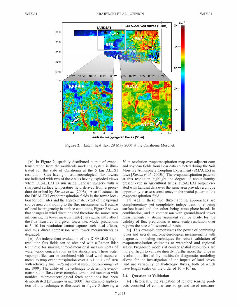
[35] In Figure 2, spatially distributed output of evapo-transpiration from the multiscale modeling system is illus-trated for the state of Oklahoma at the 5 km ALEXIresolution. Sites having micrometeorological flux towersare indicated with two of these sites having exploded viewswhere DISALEXI is run using Landsat imagery with asharpened surface temperature field derived from a proce-dure described by Kustas et al. [2003a]. Also illustrated inthe DISALEXI evapotranspiration fields is the tower loca-tion for both sites and the approximate extent of the upwindsource area contributing to the flux measurements. Becauseof local heterogeneity in surface conditions, Figure 2 showsthat changes in wind direction (and therefore the source areainfluencing the tower measurements) can significantly affectthe flux measured at a given tower site. Model predictionsat 5–10 km resolution cannot capture such local effects,and thus direct comparison with tower measurements isdegraded.[36] An independent evaluation of the DISALEXI high-
resolution flux fields can be obtained with a Raman lidartechnique for making three-dimensional measurements ofwater vapor concentration in the atmosphere. These watervapor profiles can be combined with local wind measure-ments to map evapotranspiration over a �1 � 1 km2 areawith relatively fine (�25 m) spatial resolution [Eichinger etal., 1999]. The utility of the technique to determine evapo-transpiration fluxes over complex terrain and canopies withnonideal micrometeorological fetch conditions has beendemonstrated [Eichinger et al., 2000]. An example applica-tion of this technique is illustrated in Figure 3 showing a
30 m resolution evapotranspiration map over adjacent cornand soybean fields from lidar data collected during the SoilMoisture Atmosphere Coupling Experiment (SMACEX) inIowa [Kustas et al., 2003b]. The evapotranspiration patternsat this resolution highlight the degree of nonuniformitypresent even in agricultural fields. DISALEXI output cre-ated with Landsat data over the same area provides a uniqueopportunity to assess consistency in the spatial pattern of theevapotranspiration field.[37] Again, these two flux-mapping approaches are
complementary yet completely independent, one beingsurface-based and the other being atmosphere-based. Incombination, and in comparison with ground-based towermeasurements, a strong argument can be made for thevalidity of flux predictions at meter-scale resolution overregions the size of a watershed basin.[38] This example demonstrates the power of combining
tower and aircraft micrometeorological measurements withdiagnostic modeling techniques for robust validation ofevapotranspiration estimates at watershed and regionalscales. Prognostic models at coarser spatial resolutions aremore difficult to validate directly. Furthermore, the range inresolution afforded by multiscale diagnostic modelingallows for the investigation of the impact of land cover/land use variability on hydrologic fluxes, both of whichhave length scales on the order of 101–102 m.
2.4. Question 4: Validation
[39] Historically, the validation of remote sensing prod-ucts consisted of comparisons to ground-based measure-
Figure 2. Latent heat flux, 29 May 2000 at the Oklahoma Mesonet.
W07301 KRAJEWSKI ET AL.: OPINION
7 of 13
W07301

ments with the goal of having the former match the latter.Too often the comparisons were based on short fieldcampaigns, and the retrieval algorithms applied to areas ofquestionable validity without any statement of their uncer-tainty. This approach to validation needs to be revised. Wedefine validation as quantitative determination of uncertaintyof remote sensing products. Thus the problem of validationbecomes equivalent to answering the question: What is thestatistical structure of uncertainties associated with remotesensing products at different space-time scales?[40] Implicit in this questions are issues of error definition
(additive or multiplicative), and determination of bias,probability distribution of the errors with their momentcharacterization, and spatial and temporal dependence.Adequate ground-based observations either are too sparseor do not exist. Their measurement errors are often not wellrecognized. Thus the observatory offers the opportunity todevelop new rigorous approaches for validating, i.e., eval-uating, remote sensing products.[41] To demonstrate how a RSO could help address the
validation issue, we use an example of radar-rainfall esti-mation. Prior to the advent of remote sensing, hydrologistsrelied on rain gauge networks and suffered from an inabilityto account for the high spatial and temporal variability ofrainfall. While the arrival of radar networks, e.g., theNEXRAD system in the United States, has dramaticallyimproved our ability to detect storms and offered hydrolo-gists a wealth of information on the spatial and temporalstructure of rainfall systems, quantifying the uncertainty ofrainfall estimates remains an important challenge [e.g.,Krajewski and Smith, 2002]. Unless the uncertainty ofradar-rainfall products is quantified, the research benefitsof the data will be limited.[42] The main challenge in designing a network adequate
for rainfall validation purposes is closing the scale gap.Considering that rain gauge and weather radar have sensorsampling areas differing by some 8 orders of magnitude, itis clear that the challenge is significant and cannot beaddressed by a standard operational network.[43] In our vision the rainfall validation network will
comprise several types of sensors [Krajewski, 2006]: (1)
standard rain gauges to facilitate transferability of results,(2) disdrometers, i.e., devices for measuring drop sizedistribution (DSD), as these are fundamental to radar (andsatellite) remote sensing of rainfall, (3) vertically pointingradars, as the vertical variability of precipitating cloud andrain systems seems to be of fundamental importance foraddressing the radar-rainfall estimation problem, and (4) anetwork of specialized inexpensive radars to provide veryhigh resolution observations.[44] A strategy based on a colocated collection of the
instruments listed above requires characterization of point-scale measurement error. In the case of tipping bucket raingauge data, Habib et al. [2001] and Ciach [2003] conductedexperimental studies that provide mathematical models ofrain gauge rainfall accumulation random errors. The stan-dard errors decrease with increasing rain amount and timeintegration scale. Another conclusion from these studies isthat tipping bucket rain gauges, when well maintained anddeployed as a pair [Ciach and Krajewski, 1999; Steiner etal., 1999; Cruse et al., 2006] provide accurate observationof rainfall accumulations at scales from 10 min up. Sys-tematic errors in rain gauge measurements can be attributedto wind effect that has been extensively studied experimen-tally [e.g., Sevruk and Hamon, 1984; Yang et al., 1998], andrecently numerically [Nespor et al., 2000; Habib andKrajewski, 2001; Constantinescu et al., 2006].[45] Validation of hydrologic variables, rainfall in partic-
ular, using in situ data requires separation of the effects ofnatural variability from the measurement/estimation uncer-tainty [Ciach and Krajewski, 1999]. This, in turn, impliesthe need for estimation and characterization of the variabil-ity in space and time across spatial and temporal scales. Forrainfall this requires specialized networks [e.g., Moore etal., 2000; Habib and Krajewski, 2002; Krajewski et al.,2003; Ciach and Krajewski, 2006].[46] Closing the scale gap would be achieved by using
high-resolution short range X-band polarimetric radars [e.g.,Matrosov et al., 1999; Zrnic and Ryzhkov, 1999; Matrosovet al., 2002; Anagnostou et al., 2004] operated as a network[Krajewski, 2006]. Attenuation of X-band signal by rainfallwould be mitigated by use of multiparameter algorithms,
Figure 3. Output of latent heat flux from lidar-based technique over corn and soybean fields in centralIowa in comparison to DISALEXI output using aircraft imagery during SMACEX.
8 of 13
W07301 KRAJEWSKI ET AL.: OPINION W07301
multiple radars ‘‘seeing’’ the same location, and othercorrections [e.g., Berne and Uijlenhoet, 2005]. With spatialresolution on the order of 100 m, the effect of spatialvariability of rainfall becomes negligible and in situ datacan be used to estimate the error structure of these radars,which in turn, ‘‘connect’’ to NEXRAD’s network of radarand satellite rainfall estimates. Disdrometers and profilers(i.e., vertically pointing radars) provide additional contextand information relevant to rainfall estimation using remotesensing. By measuring raindrop size distribution (DSD) anddrop velocity, disdrometers allow us to estimate spatialvariability of radar reflectivity, as well as other rainfallcharacteristics. Since disdrometers measure DSD indirectlyand the cumulative experience with their operation is muchless than with rain gauges, they require thorough testing.Several disdrometer intercomparison experiments pointto the sensitivity of the results to the instrument type[Sheppard and Joe, 1994; Campos and Zawadzki, 2000;Williams et al., 2000; Tokay et al., 2001; Miriovsky et al.,2004; Krajewski et al., 2006.][47] Vertically pointing Doppler radars (VPR) provide
crucial information for radar remote sensing. They arecapable of observing vertical profiles of precipitating cloudsthus identifying features affecting radar observables. Thesefeatures include thickness and height of the melting ice atcloud base (i.e., bright band problem), precipitation phase,convective cores, updrafts and downdrafts, etc. They arealso capable of providing estimates of the vertical profile ofDSD. These estimates are more reliable if the profileroperates at multiple frequencies so that air and raindropmotion can be distinguished. Profiler-based studies ofprecipitation systems and the related instrumental andestimation issues have been well documented in a numberof publications [e.g., Wakasugi et al., 1986; Gage et al.,1999, 2000, 2002; Williams et al., 2000; Williams, 2002;Kollias et al., 2002].[48] Development and operation of a network of radars,
in concert with other ground-based sensors at a rainfallvalidation site, offers numerous advantages. For example,consider a network of four radars overlooking a regulardense network of rain gauges. Its operation can lead to(1) improved accuracy of rainfall algorithms, (2) increasedresolution, (3) increased reliability, (4) reduced develop-ment and operating costs, and (5) repeatability. Still, muchresearch remains before we can fully realize the abovebenefits. Research needed includes technological advance-ments of radar hardware, development of software tooperate the radar as a true network and not simply acollection of four individual radars, and refinement ofrainfall estimation algorithms.[49] Many of the issues we discussed using validation of
rainfall as an example apply to other, but not all, hydrologicvariables. For some of the variables, e.g., soil moisture,additional complications immediately come to mind: thevalidation setup needs to take into account effects oftopography, soil type and distribution, and vegetation cover,among others.
3. Design of a Remote Sensing Observatory
[50] Up to this point we have discussed the remotesensing observatory somewhat in the abstract. In this
section we provide more details. A broad definition of theRSO is a piece of land that is well instrumented with in situand ground-based high-resolution remote sensing instru-ments that allow detailed observations of the hydrologicprocesses occurring at the site. In that respect, the RSO isquite similar to a hydrologic observatory with the maindifference being the size. We contend that the area of a RSOdoes not need to be larger than about 10 km by 10 km. Sucha size is greater than the resolution of most remote sensingplatforms, yet not too large to be unmanageable. Thequestions ‘‘Where?’’ and ‘‘How many?’’ immediately fol-low. However, as these questions are not critical to estab-lishing the soundness of the concept, we will not addressthem at this time.[51] Issues relevant to site selection include variability of
the hydrometeorological processes, access to land, and howwell it represents other areas. Obviously, we need to samplea range of conditions; a place where it rarely rains wouldnot be a good choice for remote sensing of rainfall studies.A site having good seasonal variability and representingboth cold and warm season processes and their transitionswould be preferred. On the other hand, difficult terrainimposes unnecessary obstacles early in our efforts. Amountainous site would make more sense after we convinceourselves, as a community, of the merits of the RSOconcept. By the same token, one could argue for a multisitedynamic adaptable facility designed to sample a broadrange of heterogeneities focused on variability in vegeta-tion, terrain, and hydroclimatic conditions. This would bepossible with participation by a broad international hydro-logic community.[52] After site selection the next critical questions are,
‘‘What instruments should be deployed, how many of themdo we need, and in what configuration?’’ As our examplesabove illustrate, the answer depends on the variable ofinterest. With some (e.g., rainfall), our knowledge is suffi-cient to address the specific design issues now; for othervariables (e.g., soil moisture) we have major gaps in ourunderstanding. Still, this should not stop us from making thecommitment and developing a RSO. The whole point is thatthe observatory is a ‘‘playground’’ where we can easilymodify, enhance, and adapt the sensor network as ourknowledge of the relevant processes increases. For manyvariables, the scale of the variability may be such that itwould prevent dense deployment of sensors. In that case,we should consider nested design that would enable gradualbridging of the scale gap and enable upscaling studies. Forother variables we need to consider one or more specificlocations representative of elements present in the observa-tory, to later allow integration of the entire domain or thescale relevant for a particular remote sensor. For example,rather than deploying a uniform network of flux towers, wemay deploy them at the locations with topography and landuse characteristics representative for the particular RSO site.Understanding evaporation over corn or forest at someselected sites would allow upscaling to a larger domain.In some cases we may need to resort to virtual realitymodeling of the local hydrologic processes based on ourcurrent state of knowledge for the design of our observa-tional network.[53] What variables are of primary interest? It seems that
the priority should be the variables that control or deter-
W07301 KRAJEWSKI ET AL.: OPINION
9 of 13
W07301
mine near surface states and fluxes of mass and energytransfer. Precipitation, soil moisture content, and evapo-transpiration are the basic variables that constitute a core ofobservations for a wide variety of hydrologic studies. Themeasurements would include several components of theradiative energy balance, surface, and near-surface temper-atures, other properties of the landscape such as vegetationcharacteristics, as well as boundary layer processes includ-ing wind profiles.[54] Other principles of the RSO design include high and
well-determined quality of the data, redundancy of infor-mation, oversampling design, immediate access to data bythe entire research community, long-term deployment,automation of data collection, etc. Selection and deploy-ment of specific instruments should be preceded by carefulcomparisons and short-term experiments, while the double-sensor principle will aid in data quality control and in situerror characterization. The length of deployment of aparticular set of instruments at a given location should beguided by frequent assessment of the need to help ourunderstanding. Thus, if we as community feel that aparticular aspect of remote sensing is well understoodand dealt with, we can move on to study another. Forexample, if we understand measurements and estimation ofevapotranspiration over uniform vegetation on flat terrain,there is little sense in continuing to maintain an array ofinstrumentation doing just that. The design of the RSOshould be inherently flexible to allow for reconfiguration ofthe site as hypotheses are tested and new hypotheses areformulated.[55] We have estimated that the cost of establishing a
RSO would be about $10 million, with about $5 million ayear to run the facility. In our calculations we assumeddeployment of only ground-based instruments; having anaircraft available to the facility would add additional cost.The staff of the observatory would be about 10–15 highlyqualified scientists, engineers, and technicians. The datadistribution, archival, and mining would be handled by theInformation Technology unit of the RSO. Considering thecost of a single satellite mission, the above price, while onlya rough estimate, seems a bargain. The new capabilityafforded to the research community would quickly resultin value added products and would pave the way for futureadvances.
4. Closing Remarks
[56] The concept of the remote sensing observatory wepropose should be viewed as development of new capabil-ities and not as a large-scale experiment. For remote sensingto be useful in studies at hydrologic observatories as well asin monitoring continental and global-scale water resources,it needs to be investigated through a series of focusedstudies. A number of questions and issues remain; we havediscussed some of them in this paper. We need a statisticalapproach to test for consistency between remote sensing andground data. We need to quantify uncertainty in derivedremote sensing products and ground measurements. Weneed to improve our understanding of subgrid heterogeneityand its effects on hydrologic processes. We need to developapproaches to assimilate remote sensing data and productsinto new models and theories.
[57] At remote sensing observatories many variableswould be monitored at comparable scales. The necessityof this multicomponent approach has been recognized bythose currently involved in remote sensing validationefforts. For example, the SMEX 2002 experiment in Iowahas demonstrated the value of boundary layer and watervapor monitoring for interpretation of passive microwaveremote sensing of soil moisture. Even in validation ofprecipitation (seemingly an external input) the informationon three-dimensional wind structure, atmospheric stabilityand humidity of the prestorm and poststorm environmentare critical for proper interpretation of the results.[58] How should we go about establishing RSOs? While
the developing structure of the CUAHSI seems well suitedfor the task, it is still somewhat of a moving target.Therefore we resist temptation of putting our RSO conceptinto the framework of CUAHSI. Our main objective in thispaper was proposing a concept, not a design. We hope thispaper will stimulate the hydrologic community to initiatemore discussion on the issues and needs we raise herein. Asthe scope of remote sensing is wide, developing smallerfocused prototypes of RSOs may be a good first step toconsider. In designing such prototypes we should capitalizeon lessons learned from previous community experimentssuch as FIFE, BOREAS, HAPEX-Mobilhy, HAPEX-Sahel,LBA, etc., and coordinate with efforts of agencies involvedin hydrologic remote sensing.[59] A remote sensing observatory would allow us to
assess more quantitatively the state-of-the-art on remotesensing and hydrologic prediction, thus providing a crediblepath toward future progress. Without being able to deter-mine the uncertainty of many remote sensing products, it ishard to argue for resources needed for future progress. Sincebuilding observational systems is expensive, societal deci-sions leading to such investments need to be firmly based inscience. The RSO will greatly improve our capability tomake credible scientific recommendations of resourceinvestments, including those directly affecting the researchenterprise.
[60] Acknowledgments. Preparation of this paper was stimulated bythe CUAHSI’s call for research agenda visions in different aspects ofhydrology. With NSF grant 03-26064, the consortium funded a workshop in2004 attended by most of the authors of this paper, during which theconcept of a national remote sensing observatory was conceived. The firstauthor also acknowledges support from the NASA’s Iowa Space GrantConsortium and the Rose and Joseph Summers Chair in Water ResourcesEngineering for his work leading to the concept of the Iowa Validation Siteas an early precursor of the RSO concept.
ReferencesAnagnostou, E. N., M. N. Anagnostou, A. Kruger, W. F. Krajewski, andB. Miriovsky (2004), High-resolution rainfall estimation from X-bandpolarimetric radar measurements, J. Hydrometeorology, 43(1), 106–118.
Anderson, M. C., J. M. Norman, G. R. Diak, W. P. Kustas, and J. R.Mecikalski (1997), A two-source time-integrated model for estimatingsurface fluxes using thermal infrared remote sensing, Remote Sens. En-viron., 60, 195–216.
Anderson, M. C., J. M. Norman, J. R. Mecikalski, R. D. Torn, W. P. Kustas,and J. B. Basara (2004), A multiscale remote sensing model for disaggre-gating regional fluxes tomicrometeorological scales, J. Hydrometeorol., 5,343–363.
Atlas, R. M. (1997), Atmospheric observations and experiments to assesstheir usefulness in data assimilation, J. Meteorol. Soc. Jpn., 75(1B),111–130.
10 of 13
W07301 KRAJEWSKI ET AL.: OPINION W07301

Berne, A., and R. Uijlenhoet (2005), A stochastic model of range profiles ofraindrop size distributions: Application to radar attenuation correction,Geophys. Res. Lett., 32, L10803, doi:10.1029/2004GL021899.
Bindlish, R., and A. P. Barros (2002), Subpixel variability of remotelysensed soil moisture: An inter-comparison study of SAR and ESTAR,IEEE Trans. Geosci. Remote Sens., 40(2), 326–337.
Bloschl, G., and M. Sivapalan (1995), Scale issues in hydrologicalsciences—A review, Hydrol. Processes, 9(3–4), 251–290.
Bosilovich, M. G. (2002), On the use and validation of mosaic heteroge-neity in atmospheric numerical models, Geophys. Res. Lett., 29(8), 1174,doi:10.1029/2001GL013925.
Brown, J. H., V. K. Gupta, B. Li, B. T. Milne, C. Restrepo, and G. W. West(2002), The fractal nature of nature: Power laws, ecological complexityand biodiversity, Philos. Trans. R. Soc. London, Ser. B, 357, 619–626.
Burke, E. J., R. J. Gurney, L. P. Simmonds, and P. E. O’Neill (1998), Using amodelling approach to predict soil hydraulic properties from passive micro-wave measurements, IEEE Trans. Geosci. Remote Sens., 36, 454–462.
Campos, E., and I. Zawadzki (2000), Instrumental uncertainties in Z-Rrelations, J. Appl. Meteorol., 39, 1088–1102.
Ciach, G. J. (2003), Local random errors in tipping-bucket rain gaugemeasurements, J. Atmos. Oceanic Technol., 20(5), 752–759.
Ciach, J. G., and W. F. Krajewski (1999), On the estimation of radar-rainfallerror variance, Adv. Water Resour., 22(6), 585–595.
Ciach, G. J., and W. F. Krajewski (2006), Analysis and modeling of spatialcorrelation structure of small-scale rainfall in Central Oklahoma, Adv.Water Resour., in press.
Constantinescu, G. S., W. F. Krajewski, C. E. Ozdemir, and T. Tokyay(2006), Simulation of airflow around rain gauges: Comparison of LESwith RANS, Adv. Water Resour., in press.
Cooper, D., W. E. Eichinger, D. Holtkamp, R. Karl Jr., C. Quick,W. Dugas, and L. Hipps (1992), Spatial variability of water-vaporturbulent transfer within the boundary layer, Boundary Layer Meteorol.,61, 389–405.
Cooper, D. I., W. E. Eichinger, L. Hipps, J. Kao, J. Reisner, S. Smith, S. M.Schaeffer, and D. G. Williams (2000), Spatial and temporal properties ofwater vapor and flux over a riparian canopy, Agric. For. Meteorol., 105,161–183.
Crow, W. T., and E. F. Wood (1999), Multi-scale dynamics of soil moisturevariability observed during SGP’97, Geophys. Res. Lett., 26(23), 3485–3488.
Crow, W. T., and E. F. Wood (2003), The assimilation of remotely sensedsoil brightness temperature imagery into a land-surface model using en-semble Kalman filtering: A case study based on ESTAR measurementsduring SGP97, Adv. Water Resour., 26, 137–149.
Crow, W. T., E. F. Wood, and R. Dubayah (2000), Potential for downscalingsoil moisture maps derived from space imaging radar data, J. Geophys.Res., 105(D21), 2203–2212.
Cruse, R. M., et al. (2006), Daily estimates of rainfall, water runoff, and soilerosion in Iowa, J. Soil Water Conservation, in press.
Dobson, M. C., F. T. Ulaby, M. T. Hallikainen, and M. A. El-Rayes (1985),Microwave dielectric behaviour of wet soil—Part II: Dielectric mixingmodels, IEEE Trans. Geosci. Remote Sens., 23, 35–46.
Doran, J. C., and S. Zhong (2000), A study of the effects of subgrid-scaleland use differences on atmospheric stability in prestorm environments,J. Geophys. Res., 105, 9381–9392.
Drusch, M., E. F. Wood, and H. Gao (2005), Observation operators for thedirect assimilation of TRMM microwave imager retrieved soil moisture,Geophys. Res. Lett., 32, L15403, doi:10.1029/2005GL023623.
Dunne, S., and D. Entekhabi (2005), An ensemble-based reanalysis ap-proach to land data assimilation, Water Resour. Res., 41, W02013,doi:10.1029/2004WR003449.
Eichinger, W. E., D. I. Cooper, W. Cottingame, P. R. Forman, J. Griegos,M. A. Osborn, D. Richter, L. L. Tellier, and R. Thornton (1999), Thedevelopment of Raman water-vapor and elastic aerosol lidars for theCentral Equatorial Pacific Experiment, J. Atmos. Oceanic Technol.,16(11), 1753–1766.
Eichinger, W. E., D. I. Cooper, L. C. Chen, L. Hipps, C.-Y. J. Kao, andJ. Prueger (2000), Estimation of spatially distributed latent heat fluxover complex terrain from a Raman lidar, Agric. For. Meteorol., 105,145–159.
Entekhabi, D., et al. (2004), The hydrosphere state (Hydros) satellite mis-sion: An Earth system pathfinder for global mapping of soil moisture andland freeze/thaw, IEEE Trans. Geosci. Remote Sens., 42(10), 2184–2195, doi:10.1109/TGRS.2004.834631.
Famiglietti, J. S., and E. F. Wood (1995), Effects of spatial variability andscale on areal-average evapotranspiration, Water Resour. Res., 31(3),699–712.
Famiglietti, J. S., J. A. Devereaux, C. A. Laymon, T. Tsegaye, P. R. Houser,T. J. Jackson, S. T. Graham, M. Rodell, and P. J. van Oevelen (1999),Ground-based investigation of soil moisture variability within remotesensing footprints during the Southern Great Plains 1997 (SGP97) hy-drology experiment, Water Resour. Res., 35, 1839–1851.
Gage, K. S., C. R. Williams, W. L. Ecklund, and P. E. Johnston (1999), Useof two profilers during MCTEX for unambiguous identification of Braggscattering and Rayleigh scattering, J. Atmos. Sci., 56, 3679–3691.
Gage, K. S., C. R. Williams, P. E. Johnston, W. L. Ecklund, R. Cifelli,A. Tokay, and D. A. Carter (2000), Doppler radar profilers as a calibra-tion tools for scanning radars, J. Appl. Meteorol., 39, 2209–2222.
Gage, K. S., C. R. Williams, W. L. Clark, P. E. Johnston, and D. A. Carter(2002), Profiler contributions to Tropical Rainfall Measuring Mission(TRMM) ground validation field campaigns, J. Atmos. Oceanic Technol.,19, 843–863.
Gupta, V. K., and E. Waymire (1990), Multiscaling properties of spatialrainfall and river flow distributions, J. Geophys. Res., 95(D3), 1999–2009.
Gupta, V. K., S. Castro, and T. M. Over (1996), On scaling exponents ofspatial peak flows from rainfall and river network geometry, J. Hydrol.,187(1–2), 81–104.
Habib, E., and W. F. Krajewski (2001), An example of computationalapproach used for aerodynamic design of a rain disdrometer, J. Hydraul.Res., 39(4), 425–428.
Habib, E., and W. F. Krajewski (2002), Uncertainty analysis of the TRMMground validation radar-rainfall products: Application to the TEFLUN-Bfield campaign, J. Appl. Meteorol., 41(5), 558–572.
Habib, E., W. F. Krajewski, and A. Kruger (2001), Sampling errors of fineresolution tipping-bucket rain gauge measurements, J. Hydrol. Eng.,6(2), 159–166.
Hills, R. C., and S. G. Reynolds (1969), Illustrations of soil moisturevariability in selected areas and plots of different sizes, J. Hydrol., 8,27–47.
Hornbuckle, B. K., and A. W. England (2004), Radiometric sensitivity tosoil moisture at 1.4 GHz through a corn crop at maximum biomass,Water Resour. Res., 40, W10204, doi:10.1029/2003WR002931.
Hornbuckle, B. K., and A. W. England (2005), Diurnal variation of verticaltemperature gradients within a field of maize: Implications for SatelliteMicrowave Radiometry, IEEE Geosci. Remote Sens. Lett., 2(1), 74–77,doi:10.1109/LGRS.2004.841370.
Hornbuckle, B. K., A. W. England, R. D. De Roo, M. A. Fischman, andD. L. Boprie (2003), Vegetation canopy anisotropy at 1.4 GHz, IEEETrans. Geosci. Remote Sens., 40(10), 2211 – 2223, doi:10.1109/TGRS.2003.817192.
Houser, P. R., W. J. Shuttleworth, J. S. Famiglietti, H. V. Gupta, K. H. Syed,and D. C. Goodrich (1998), Integration of soil moisture remote sensingand hydrologic modeling using data assimilation, Water Resour. Res.,34(12), 3405–3420.
Jackson, T. J. (2001), Multiple resolution analysis of L–band brightnesstemperature for soil moisture, IEEE Trans. Geosci. Remote Sens., 39,151–164.
Judge, J., J. F. Galantowicz, and A. W. England (2001), A comparison ofground–based and satellite–borne microwave radiometric observationsin the Great Plains, IEEE Trans. Geosci. Remote Sens., 39(8), 1686–1696.
Kachanoski, R. G., and E. de Jong (1988), Scale dependence and thetemporal persistence of spatial patterns of soil water storage, Water Re-sour. Res., 24(1), 85–91.
Katul, G. G., P. Todd, D. Pataki, Z. J. Kabala, and R. Oren (1997), Soilwater depletion by oak trees and the influence of root water uptake on thesoil moisture content spatial statistics, Water Resour. Res., 33, 611–623.
Katul, G. G., J. J. Finnigan, D. Poggi, R. Leuning, and S. Belcher (2006),The influence of hilly terrain on canopy-atmosphere carbon dioxideexchange, Boundary Layer Meteorol., 118, 189–216.
Kerr, Y. H., P. Waldteufel, J.-P. Wigneron, J.-M. Martinuzzi, J. Font, andM. Berger (2001), Soil moisture retrieval from space: The soil moistureand ocean salinity (SMOS) mission, IEEE Trans. Geosci. Remote Sens.,39(8), 1729–1735.
Kim, E. J., and A. W. England (2003), A yearlong comparison of plot-scaleand satellite footprint-scale 19 and 37 GHz brightness of the AlaskanNorth Slope, J. Geophys. Res., 108(D13), 4388, doi:10.1029/2002JD002393.
Kollias, P., B. A. Albrecht, and F. Marks, Jr. (2002), Why Mie? Accurateobservations of vertical air velocities and raindrops using a cloud radar,Bull. Am. Meteorol. Soc., 83, 1471–1483.
Krajewski, W. F. (2006), Ground networks: Are we doing the right thing?,in Rainfall Estimation From Space, Springer, New York, in press.
W07301 KRAJEWSKI ET AL.: OPINION
11 of 13
W07301

Krajewski, W. F., and J. A. Smith (2002), Radar hydrology: Rainfall esti-mation, Adv. Water Resour., 25, 1387–1394.
Krajewski, W. F., G. J. Ciach, and E. Habib (2003), An analysis of small-scale rainfall variability in different climatological regimes, Hydrol. Sci.J., 48(2), 151–162.
Krajewski, W. F., A. Kruger, C. Caracciolo, P. Gole, L. Barthes, J.-D.Creutin, J.-Y. Delahaye, E. I. Nikolopoulos, F. Ogden, and J.-P. Vinson(2006), DEVEX-Disdrometer Evaluation Experiment: Basic results andimplications for hydrologic studies, Adv. Water Resour., 29, 311–325.
Kustas, W. P., J. M. Norman, M. C. Anderson, and A. N. French (2003a),Estimating subpixel surface temperatures and energy fluxes from thevegetation index-radiometric temperature relationship, Remote Sens.Environ., 85, 429–440.
Kustas, W. P., T. J. Jackson, J. H. Prueger, J. L. Hatfield, and M. C.Anderson (2003b), Remote sensing field experiments for evaluating soilmoisture retrieval algorithms and modeling land-atmosphere dynamics incentral Iowa, Eos Trans. AGU, 84(45), 492–493, 485.
Kustas, W. P., J. L. Hatfield, and J. H. Prueger (2005), The Soil Moisture–Atmosphere Coupling Experiment (SMACEX): Background, hydrome-teorological conditions, and preliminary findings, J. Hydrometeorol.,6(6), 791–804.
Laymon, C. A., W. L. Crosson, T. J. Jackson, A. Manu, and T. D. Tsegaye(2001), Ground-based passive microwave remote sensing observations ofsoil moisture at S-band and L-band with insight into measurement accu-racy, IEEE Trans. Geosci. Remote Sens., 39, 1844–1858.
Liou, Y.-A., J. F. Galantowicz, and A. W. England (1999), A land surfaceprocess radiobrightness model with coupled heat and moisture transportfor prairie grassland, IEEE Trans. Geosci. Remote Sens., 37, 1848–1859.
Margulis, S. A., and D. Entekhabi (2003), Variational assimilation of radio-metric surface temperature and reference-level micrometeorology into amodel of the atmospheric boundary layer and land surface,Mon. WeatherRev., 131(7), 1272–1288.
Matrosov, S. Y., R. A. Kropfli, R. F. Reinking, and B. E. Martner (1999),Prospects for measuring rainfall using propagation differential phase inX- and Ka-radar bands, J. Appl. Meteorol., 38, 766–776.
Matrosov, S. Y., K. A. Clark, B. E. Martner, and A. Tokay (2002), X-bandpolarimetric radar measurements of rainfall, J. Appl. Meteorol., 41, 941–952.
Mecikalski, J. M., G. R. Diak, M. C. Anderson, and J. M. Norman (1999),Estimating fluxes on continental scales using remotely-sensed data in anatmosphere-land exchange model, J. Appl. Meteorol., 38, 1352–1369.
Milne, B. T., V. K. Gupta, and C. Restrepo (2002), A scale invariantcoupling of plants, water, energy and terrain, Ecoscience, 9(2), 191–199.
Miriovsky, B. J., et al. (2004), An experimental study of small-scale varia-bility of reflectivity, J. Appl. Meteorol., 5(1), 110–128.
Mitchell, K. E., et al. (2004), The multi-institution North American LandData Assimilation System (NLDAS): Utilizing multiple GCIP productsand partners in a continental distributed hydrological modeling system,J. Geophys. Res., 109, D07S90, doi:10.1029/2003JD003823.
Moghaddam, M., S. Saatchi, and R. H. Cuenca (2000), Estimating subca-nopy soil moisture with radar, J. Geophys. Res., 105(D11), 14,899–14,911.
Mohanty, B. P., and T. H. Skaggs (2001), Spatio-temporal evolution andtime-stable characteristics of soil moisture within remote sensing foot-prints with varying soil, slope, and vegetation, Adv. Water Resour., 24,1051–1067.
Moore, R. J., D. A. Jones, D. R. Cox, and V. S. Isham (2000), Design of theHYREX raingauge network, Hydrol. Earth Syst. Sci., 4, 523–530.
Nespor, V., W. F. Krajewski, and A. Kruger (2000), Wind-induced error ofrain drop size distribution measurement using a two-dimensional videodisdrometer, J. Atmos. Oceanic Technol., 17, 1483–1492.
Njoku, E. G., W. J. Wilson, S. H. Yueh, S. J. Dinardo, F. K. Li, T. J.Jackson, V. Lakshmi, and J. D. Bolten (2002), Observations of soilmoisture using a passive and active low–frequency microwave airbornesensor during SGP99, IEEE Trans. Geosci. Remote Sens., 40(12), 2659–2673.
Nolan, M., D. R. Fatland, and L. Hinzman (2003), DINSAR measurementof soil moisture, IEEE Trans. Geosci. Remote Sens., 41(12), 2802–2813,doi:10.1109/TGRS.2003.817211.
Norman, J.M.,M. C. Anderson,W. P. Kustas, A. N. French, J. R.Mecikalski,R. D. Torn, G. R. Diak, T. J. Schmugge, and B. C. W. Tanner (2003),Remote sensing of surface energy fluxes at 101-m pixel resolutions,WaterResour. Res., 39(8), 1221, doi:10.1029/2002WR001775.
Nykanen, D. K., and E. Foufoula-Georgiou (2001), Soil moisture variabilityand scale-dependency of nonlinear parameterizations in coupled land-atmosphere models, Adv. Water Resour., 24, 1143–1157.
O’Neill, P. E., N. S. Chauhan, and T. J. Jackson (1996), Use of active andpassive microwave remote sensing for soil moisture estimation throughcorn, Int. J. Remote Sens., 17, 1851–1865.
Peters-Lidard, C. D., F. Pan, and E. F. Wood (2001), A re-examination ofmodeled andmeasured soil moisture spatial variability and its implicationsfor land surface modeling, Adv. Water Resour., 24(9–10), 1069–1083.
Reichle, R. H., D. B. McLaughlin, and D. Entekhabi (2001), Variationaldata assimilation of microwave radiobrightness observations for landsurface hydrology applications, IEEE Trans. Geosci. Remote Sens., 39,1708–1718.
Reichle, R. H., D. B. McLaughlin, and D. Entekhabi (2002), Hydrologicdata assimilation with the ensemble Kalman filter, Mon. Weather Rev.,130(1), 103–114.
Rietkerk, M., S. C. Dekker, P. C. de Ruiter, and J. van de Koppel (2004),Self-organized patchiness and catastrophic shifts in ecosystems, Science,305, 1926–1929.
Robock, A., et al. (2003), Evaluation of the North American Land DataAssimilation System over the southern Great Plains during the warmseason, J. Geophys. Res., 108(D22), 8846, doi:10.1029/2002JD003245.
Rodell, M., et al. (2004), The Global Land Data Assimilation System, Bull.Am. Meteorol. Soc., 85(3), 381–394.
Rodriguez-Iturbe, I., and A. Rinaldo (1997), Fractal River Networks:Chance and Self-Organization, Cambridge Univ. Press, New York.
Schmugge, T. J. (1978), Remote sensing of surface soil moisture, J. Appl.Meteorol., 17, 1549–1557.
Sevruk, B., and W. R. Hamon (1984), International comparison of nationalprecipitation gauges with a reference pit gauge, Instrum. Obs. MethodsRep. 17, World Meteorol. Organ., Geneva, Switzerland.
Sheppard, B. E., and P. I. Joe (1994), Comparison of raindrop size distribu-tion measurements by a Joss-Waldvogel disdrometer, a PMS 2DG spec-trometer, and a POSS Doppler radar, J. Atmos. Oceanic Technol., 11,874–887.
Sivapalan, M., et al. (2003), IAHS decade on predictions in ungaugedbasins (PUB), 2003–2012: Shaping an exciting future for the hydrolo-gical sciences, Hydrol. Sci. J., 48(6), 857–880.
Steiner, M., J. A. Smith, S. J. Burges, C. V. Alonso, and R. W. Darden(1999), Effect of bias adjustment and rain gage data quality control onradar rainfall estimates, Water Resour. Res., 35, 2487–2503.
Tenhunen, J. D., and P. Kabat (Ed.) (1999), Integrating Hydrology, Eco-system Dynamics and Biogeochemistry in Complex Terrains, DahlemWorkshop Report, 367 pp., John Wiley, Hoboken, N. J.
Tokay, A., A. Kruger, and W. F. Krajewski (2001), Comparison of drop sizedistribution measurements by impact and optical disdrometers, J. Appl.Meteorol., 40(11), 2083–2097.
Ulaby, F. T., P. P. Batlivala, and M. C. Dobson (1978), Microwave back-scatter dependence on surface roughness, soil moisture, and soil texture:Part I—Bare soil, IEEE Trans. Geosci. Electr., 16, 286–295.
Wakasugi, K., A. Mizutani, M. Matsuo, S. Fukao, and S. Kato (1986), Adirect method for deriving drop-size distributions and vertical air velo-cities from VHF Doppler radar spectra, J. Atmos. Oceanic Technol., 3,623–629.
Walker, J. P., and P. R. Houser (2005), Hydrologic data assimilation,in Advances in Water Science Methodologies [e-book], edited byA. Aswathanarayana, A. A. Balkema, Brookfield, Vt.
Wang, J. R., and T. J. Schmugge (1980), An empirical model for thecomplex dielectric permittivity of soils as a function of water content,IEEE Trans. Geosci. Remote Sens., 18, 288–295.
Weaver, C. P., and R. Avissar (2001), Atmospheric disturbances caused byhuman modification of the landscape, Bull. Am. Meteorol. Soc., 82, 269–281.
Wigneron, J.-P., A. Olioso, J.-C. Calvet, and P. Bertuzzi (1999), Estimatingroot zone soil moisture from surface soil moisture data and soil-vegeta-tion-atmosphere transfer modeling, Water Resour. Res., 35, 3735–3745.
Williams, C. R. (2002), Simultaneous ambient air motion and raindrop sizedistributions retrieved from UHF vertical incident profiler observations,Radio Sci., 37(2), 1024, doi:10.1029/2000RS002603.
Williams, C. R., A. Kruger, K. S. Gage, A. Tokay, R. Cifelli, W. F.Krajewski, and C. Kummerow (2000), Comparison of simultaneousrain drop size distributions estimated from two surface disdrometersand a UHF profiler, Geophys. Res. Lett., 27(12), 1763–1766.
Wilson, D. J., A. W. Western, and R. B. Grayson (2004), Identifying andquantifying sources of variability in temporal and spatial soil moistureobservations, Water Resour. Res., 40, W02507, doi:10.1029/2003WR002306.
Wood, E. F., K. Beven, M. Sivapalan, and L. Band (1988), Effects of spatialvariability and scale with implication to hydrologic modeling, J. Hydrol.,102, 29–47.
12 of 13
W07301 KRAJEWSKI ET AL.: OPINION W07301
Yang, D., B. E. Goodisson, and J. R. Metcalfe (1998), Accuracy ofNWS 800 standard nonrecording precipitation gauge: Results andapplication of WMO intercomparison, J. Atmos. Oceanic Technol.,15, 54–67.
Zrnic, D. S., and A. V. Ryzhkov (1999), Polarimetry for weather surveil-lance radars, Bull. Am. Meteorol. Soc., 80(3), 389–406.
����������������������������M. C. Anderson and W. P. Kustas, Hydrology and Remote Sensing
Laboratory, ARS, USDA, 10300 Baltimore Avenue, Beltsville, MD 20705,USA.
W. E. Eichinger and W. F. Krajewski, IIHR–Hydroscience andEngineering, University of Iowa, Iowa City, IA USA. ([email protected])
D. Entekhabi, Department of Civil and Environmental Engineering,MIT, Cambridge, MA 02139, USA.
B. K. Hornbuckle, Department of Agronomy, Iowa State University,3007 Agronomy Hall, Ames, IA 50011-1010, USA.
P. R. Houser, Center for Research on Environment and Water, GeorgeMason University, 4041 Powder Mill Road, Suite 302, Calverton, MD20705-3106, USA.
G. G. Katul, Nicholas School of the Environment and Earth Sciences,Duke University, PO Box 90328, Durham, NC 27708-0328, USA.
J. M. Norman, Department of Soil Science, University of Wisconsin,1525 Observatory Drive, Madison, WI 53706, USA.
C. Peters-Lidard, NASA Goddard Space Flight Center, Code 974,Building 33, Room B306, Greenbelt, MD 21042, USA.
E. F. Wood, Department of Civil and Environmental Engineering,Princeton University, Princeton, NJ 08544, USA.
W07301 KRAJEWSKI ET AL.: OPINION
13 of 13
W07301