
A Random Revisit of the Statewide Stream Survey …...samples, but a few had high (180.1 to 570...
11
30 years ago, DEEP Fisheries Biologist Neal Hagstrom led an ambitious project; to survey the rivers and streams of Connecticut. Findings indicated wild Brook Trout were commonplace, but how are these wild populations doing now? See how a random sampling of these former sites provides an answer. A Random Revisit of the Statewide Stream Survey Project Focus on Wild Brook Trout Brian Eltz and Mike Beauchene
Transcript of A Random Revisit of the Statewide Stream Survey …...samples, but a few had high (180.1 to 570...

-
30 years ago, DEEP Fisheries Biologist Neal Hagstrom led an
ambitious project; to survey the rivers and streams of
Connecticut. Findings indicated wild Brook Trout were
commonplace, but how are these wild populations doing
now? See how a random sampling of these former sites
provides an answer.
A Random Revisit of the Statewide Stream Survey Project Focus on Wild Brook Trout
Brian Eltz and Mike Beauchene
1
A Random Revisit of the Statewide Stream Survey Project: A Focus on Wild Brook Trout
Brian Eltz and Mike Beauchene
Connecticut Department of
Energy and Environmental Protection
Bureau of Natural Resources
Fisheries Division
May 2020
Introduction:
The Department of Energy and Environmental Protection (DEEP) Fisheries Division conducted a
statewide survey of Connecticut’s rivers and streams between 1988 and 1994 (Hagstrom et al. 1996).
The intent of this comprehensive project was to collect data on fish populations, physical habitat,
macroinvertebrates, water chemistry, fishing effort, and socioeconomic value. The findings of the
statewide stream survey project enabled the Fisheries Division to prepare a trout management plan,
which could be sustained by Connecticut’s stream resources and also meet the needs of Connecticut’s
anglers (Hyatt et al. 1999).
A key component of the statewide stream survey project (1988-1994) was the identification and
quantification of wild trout populations in Connecticut’s rivers and streams. From this research, it was
determined wild trout were found in many streams and rivers, being the dominant fish in numerous
The Connecticut Department of Energy and Environmental Protection is an Affirmative Action/Equal Opportunity Employer that is committed to complying with
the requirements of the Americans with Disabilities Act. Please contact us at (860) 418-5910 or [email protected] if you: have a disability and need
a communication aid or service; have limited proficiency in English and may need information in another language; or if you wish to file an ADA or Title VI
discrimination complaint.

2
small cold brooks. Of the trout species, wild Brook Trout (Salvelinus fontinalis) were the most commonly
occurring species (88% of total wild trout), followed by wild Brown Trout (Salmo trutta; 12% of total wild
trout), with wild Rainbow Trout (Oncorhynchus mykiss) being rare (< 1% of total wild trout).
Connecticut’s climate and landscape has changed over the approximately thirty-year period since the
commencement of the statewide stream survey project (increased development, warming air
temperatures, etc.) (UConn Clear 2015). In the years since, DEEP has identified water temperature and
fish species as indicators of fish habitat. Specifically, cold water habitat is defined via the presence of
wild Brook Trout, Slimy Sculpin (Cottus cognatus), or both and/or a mean summer water temperature
(June, July, August) of no warmer than 18.29 OC (Beauchene et al. 2014).
The Fisheries Division continues to monitor and collect data on Connecticut’s Fish Populations. This
sampling provides data to support understanding change in distribution across the state, trends in
abundance over time, and answer specific questions as they arise. In addition, the Water Quality
monitoring program within DEEP’s Bureau of Water Protection and Land Reuse (WPLR) collects fish
community data to inform water quality assessments to support reporting requirements of the Federal
Clean Water Act. Data on Connecticut’s fish communities (1988-2017) are available online through a
data viewer within Connecticut Environmental Conditions Online (CT ECO).
To determine the status of Connecticut’s wild Brook Trout populations and to compare to historical
statewide stream survey data, the Fisheries Division implemented a two-year resample of former
statewide stream survey sample locations. The resampling was conducted by randomly selecting a set of
former statewide stream survey sites that had wild Brook Trout present. The outcome of this finite,
short-duration, probability-based sampling project enables the Fisheries Division to make statistically
valid statements about wild Brook Trout on a statewide level.
Methods:
Site Selection: Former statewide
stream survey sites containing at least
one wild Brook Trout were randomly
chosen (without replacement) for
resampling; each site was assigned a
number through random generation
(N = 585). To ensure a final sample list
of at least 100 locations (a 95%
confidence interval and an error of
10% was determined to be
appropriate), the first 116 were
selected for potential sampling.
Working in sequential order from site
one to site 116, each site selected was
evaluated for sampling potential
through a combination of aerial
photography review using Google Earth, prior knowledge regarding access, and when needed, site visits.
If sampling access was no longer possible (private property and permission denied) or if the habitat was
no longer appropriate (e.g., beaver impoundment), the site was dropped.
3
Sampling: One hundred and seven sites were sampled over the summers of 2018 and 2019. Each site
was sampled using Smith Root electrofishing equipment (LR-24 backpacks or a 2.5 GPP Electrofisher in a
tow behind unit). Voltage settings were adjusted to conductivity at each location to reach a targeted
power output of 0.3 amps for backpack shockers (additional settings utilized were pulsed DC, a
frequency of 60 Hz, and a duty cycle of 25%). For tow behind units, duty cycle and range (low or high)
were adjusted until the desired voltage output was achieved; units were set to AC and 60 Hz for all
samples. Sample location and length was replicated where possible as to what was previously surveyed
during the early period (1988-1994). If unable to resample the exact location, an adjacent stream reach
was selected for sampling. Additionally, sample length was increased or decreased based on the
presence of a well-defined start or end (e.g. riffle or fall line). All fish were netted, identified, and
measured to the nearest centimeter and then immediately released. All fish data were entered into a
Microsoft Access relational database. Additionally, water chemistry data, sample site information (i.e.
sample length and average width), and subjective information regarding stream habitat were recorded
and entered into the same relational database.
Results:
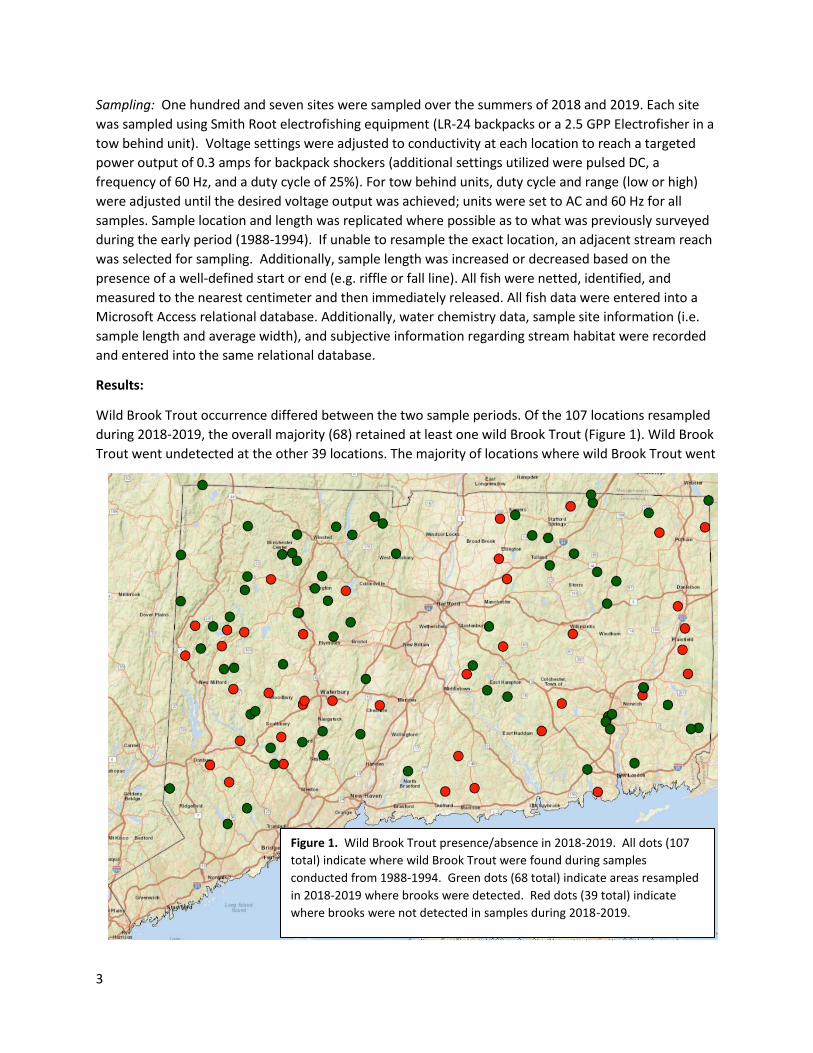
Wild Brook Trout occurrence differed between the two sample periods. Of the 107 locations resampled
during 2018-2019, the overall majority (68) retained at least one wild Brook Trout (Figure 1). Wild Brook
Trout went undetected at the other 39 locations. The majority of locations where wild Brook Trout went
Figure 1. Wild Brook Trout presence/absence in 2018-2019. All dots (107
total) indicate where wild Brook Trout were found during samples
conducted from 1988-1994. Green dots (68 total) indicate areas resampled
in 2018-2019 where brooks were detected. Red dots (39 total) indicate
where brooks were not detected in samples during 2018-2019.

4
undetected had low (0.1 – 30 fish/km) to moderate (30.1 to 180 fish/km) densities in the original
samples, but a few had high (180.1 to 570 fish/km) to very high (> 570.1 fish/km) initial densities.
Density rankings were based on quartile statistics generated from samples conducted 1988-1994.
In addition to the decrease in number of sites between both sample periods, density of wild Brook
Trout, when present, also decreased (Appendix 1). A paired T-Test of wild Brook Trout density (square-
root transformation) showed a highly significant difference (<0.001) between samples from both
periods. Mean density also decreased between the two sample periods (391 fish/km vs. 138 fish/km;
early and late periods, respectively). Overall, a large decrease in the number of high density wild Brook
Trout populations was observed, but the number of low to high density populations remained similar
(Figure 2).
Figure 2. Count of density rankings between the two sample periods. A null ranking means wild Brook Trout were
not detected.
Discussion and next steps:
Connecticut’s landscape and climate has changed over the past three decades. These changes are
predicted to continue and most likely have a negative impact on cold water obligate fish species such as
Brook Trout.
The Brook Trout is Connecticut’s only native non-migratory salmonid species. As a species with specific
cold water requirements, the future of wild Brook Trout in Connecticut in the context of climate change
and increased development is uncertain and potentially in jeopardy. The primary intent of this two-year
project was to compare wild Brook Trout populations to those documented 30 years ago. As the
approach was random (sites chosen randomly without replacement from a finite population), the results
can be used to support statements about wild Brook Trout populations in Connecticut. Going forward
0
5
10
15
20
25
30
35
40
45
very high high moderate low null
Co
un
t
Density Ranking
Brook Trout Density Rankings
1988-1994 2018-2019

5
we recommend re-drawing a new list of randomly selected sites every 5-years in order to compile a
series of statewide estimates of wild Brook Trout distribution and population density values.
Starting now, additional work using the universe of locations where wild Brook Trout were not observed
is warranted. This work should seek to identify key variables responsible or related to the absence of
wild Brook Trout and determine their magnitude of change. Some categories of variables, which may
have changed from the initial sampling over 30 years ago include land cover, out of stream diversion of
water (including groundwater), and recreational fisheries management (stocking of adult domestic trout
(brooks, browns, rainbows, and tigers) in the same reach containing wild populations, stocking of
Atlantic Salmon and Brown Trout fry, harvest limits, size limits, etc.).
The creation of a wild trout management plan has been identified in the Statewide Salmonid Action Plan
(CT DEEP in draft) as an important next step to ensure this natural resource remains viable and
sustainable. Several potential actions to be addressed in this plan are included as Appendix 2.
Citations:
Beauchene, M., M. Becker, C. J. Bellucci, N. Hagstrom & Y. Kanno (2014) Summer Thermal Thresholds of
Fish Community Transitions in Connecticut Streams, North American Journal of Fisheries
Management, 34:1, 119-131, DOI: 10.1080/02755947.2013.855280
Hagstrom, N. T., M. Humphreys, W.A. Hyatt, and W.B. Gerrish. 1996. A survey of Connecticut streams
and rivers. Connecticut Department of Environmental Protection, Final Report, F-66-R.
Hyatt, W. A., M. Humphreys, N. T. Hagstrom. 1999. A trout management plan for Connecticut’s rivers
and streams. Final Report F-66-R. Job 4.
UConn CLEAR. 2015. E. Wilson.
http://clear.uconn.edu/projects/landscape/CT/stats/change19852015.htm#top

6
Appendices:
Appendix 1. Waterbodies, sorted alphabetically, resampled during 2019-2019 along with wild Brook Trout
densities from both sample periods. Station ID refers to the unique sample location.
STATION NAME STATION ID MUNICIPALITY 1988-1994 NUMBER/KM
2018-2019 NUMBER/KM
ABBEY BROOK 16467 SOMERS 280 0
ABORN BROOK 16469 ELLINGTON 1580 160
ASPETUCK RIVER 16478 NEWTOWN 130 0
BEACON HILL BROOK 18126 BEACON FALLS 40 7
BEAVER BROOK 15680 BARKHAMSTED 440 333
BEAVER POND BROOK 14130 WATERBURY 9 0
BEBBINGTON BROOK 15988 ASHFORD 10 10
BIGELOW BROOK 16506 EAST HAMPTON 200 17
BLACKLEDGE RIVER 16517 MARLBOROUGH 8 0
BLACKMORE BROOK 16450 THOMPSON 20 0
BONEMILL BROOK 14141 TOLLAND 1360 346
BROWNS BROOK, TRIBUTARY TO 16533 UNION 740 540
BUCK BROOK 16535 PORTLAND 960 600
BUTTONBALL BROOK 16548 CHAPLIN 170 120
CARR BROOK 16556 PORTLAND 13 0
CAVANAUGH BROOK 16560 NEWTOWN 20 0
CHOATE BROOK 16572 PRESTON 7 0
COBBLE BROOK, TRIBUTARY TO 17141 KENT 330 0
CROOKED BROOK 16597 NORTH BRANFORD
950 220
CURTIS BROOK 16601 WILLINGTON 400 78
DEEP RIVER 16607 COLCHESTER 580 0
DENMAN BROOK 16610 NEW MILFORD 280 20
EAST ASPETUCK RIVER, TRIBUTARY TO
17142 WASHINGTON 60 0
EAST BR. NAUGATUCK RIVER, TRIBUTARY TO
17145 TORRINGTON 1220 109
EAST BRANCH LEADMINE BROOK 16623 NEW HARTFORD 620 118
EAST BRANCH SHEPAUG RIVER 16630 GOSHEN 440 679
EAST SWAMP BROOK 14184 BETHEL 140 0
EIGHTMILE BROOK 14186 OXFORD 7 0
EIGHTMILE RIVER 14605 SOUTHINGTON 20 22
EIGHTMILE RIVER 15179 EAST HADDAM 7 0
EKONK BROOK 14888 PLAINFIELD 20 0
FENN BROOK 16656 ROXBURY 100 0
FORD BROOK 16668 NORWICH 180 32
FOX BROOK 16674 WINCHESTER 90 24
GOODWIN BROOK 16697 CHAPLIN 1278 258
GRAVELLY BROOK 16699 WOODSTOCK 680 13
GREAT BROOK 16702 GROTON 22 44

7
GREEN BROOK 16705 TOLLAND 140 302
GULF STREAM 16713 SOMERS 267 792
HALFWAY RIVER 16718 MONROE 12 30
HALL MEADOW BROOK 16126 NORFOLK 6 345
HAWLEYS BROOK 16731 WESTON 1950 520
HOCKANUM RIVER 14238 ELLINGTON 2 0
HOP BROOK 16748 MIDDLEBURY 129 0
HOPP BROOK 16750 BETHANY 1486 757
HUMISTON BROOK 16762 LITCHFIELD 30 0
INDIAN RIVER 16772 KILLINGWORTH 20 0
IVY MOUNTAIN BROOK 16778 GOSHEN 30 0
JEFFERSON HILL BROOK 15062 LITCHFIELD 360 188
JEREMY BROOK 16783 SOUTHBURY 10 0
KETTLE BROOK 16116 BARKHAMSTED 1610 200
KETTLETOWN BROOK 15577 SOUTHBURY 320 50
KIRBY BROOK 15128 WASHINGTON 110 286
LAKE WARAMAUG BROOK ("SUCKER BROOK")
16795 WARREN 7 0
LAKE WARAMAUG BROOK, TRIBUTARY TO
17151 WARREN 571 267
LATHROP BROOK,TRIBUTARY TO 16797 PLAINFIELD 33 0
LISBON BROOK 16807 PRESTON 405 211
LISBON BROOK,TRIBUTARY TO 16808 PRESTON 333 421
LONG SWAMP BROOK 16817 MIDDLEBURY 180 0
MACEDONIA BROOK 16821 KENT 100 81
MAY BROOK 16831 UNION 1440 76
MILL BROOK 16451 WOODSTOCK 10 0
MILLER BROOK 16852 PRESTON 222 76
MILLSTONE BROOK 16816 WATERFORD 10 0
MOHAWK POND OUTFLOW 16857 GOSHEN 190 10
MOOSEHORN BROOK 16861 GRANBY 740 418
MOUNT MISERY BROOK 14718 VOLUNTOWN 108 0
MUDDY GUTTER BROOK 16879 EAST HAMPTON 160 177
NECK RIVER 16897 GUILFORD 40 0
NEGRO HILL BROOK 16898 BURLINGTON 1160 770
NEW CITY BROOK 16900 STAFFORD 20 0
NO NAME 16909 KILLINGWORTH 160 0
NONEWAUG RIVER 14355 WOODBURY 80 0
NONEWAUG RIVER, TRIBUTARY TO 16916 BETHLEHEM 100 27
OIL MILL BROOK 16930 WATERFORD 200 17
OWENS BROOK 16933 SIMSBURY 920 89
PENDLETON HILL BROOK 15796 NORTH STONINGTON
312 61
PHELPS BROOK 16962 BURLINGTON 20 0
POLAND RIVER 14402 PLYMOUTH 54 13

8
QUANDOCK BROOK 16985 KILLINGLY 78 0
QUINNIPIAC RIVER 14413 MERIDEN 5 0
RAILROAD BROOK 16995 VERNON 80 0
ROARING BROOK 17006 GLASTONBURY 53 75
ROCK BROOK, TRIBUTARY TO 17157 HARWINTON 500 92
ROCKY BROOK 14863 THOMPSON 840 495
RUGG BROOK 16114 WINCHESTER 1640 46
SAGES RAVINE BROOK 15505 SALISBURY 314 1450
SHEPAUG RIVER 15887 WASHINGTON 13 0
SPRUCE BROOK 15035 LITCHFIELD 347 73
STONY BROOK 16297 MONTVILLE 402 215
STONY BROOK 16298 MONTVILLE 180 133
TATETUCK BROOK 17105 EASTON 644 483
TENMILE RIVER, TRIBUTARY TO 17112 LEBANON 1280 0
TITICUS RIVER 15016 RIDGEFIELD 8 6
TORRINGFORD BROOK 17121 NEW HARTFORD 1160 155
TOWANTIC BROOK 17122 OXFORD 770 333
TRADING COVE BROOK 14731 MONTVILLE 382 283
TRANSYLVANIA BROOK, TRIBUTARY TO
17133 ROXBURY 600 264
TRANSYLVANIA BROOK, TRIBUTARY TO
17134 SOUTHBURY 1920 59
WALKER BROOK, TRIBUTARY TO 17135 NEW MILFORD 340 20
WANGUM LAKE BROOK 17172 CANAAN 184 92
WEBETUCK CREEK 14627 SHARON 25 11
WEST ASPETUCK RIVER, TRIBUTARY TO
17162 KENT 1900 444
WEST BRANCH SALMON BROOK 15703 GRANBY 71 6
WILLOW BROOK (HAMDEN) 15818 HAMDEN 173 108
WOMENSHENUCK BROOK 17206 NEW MILFORD 47 0
WYASSUP BROOK 17210 NORTH STONINGTON
453 27

9
Appendix 2. A partial listing of actions for preservation and conservation of Connecticut’s wild Brook
Trout for inclusion in a management plan for Connecticut’s wild trout populations.
Monitoring:
- Conduct additional sampling at specific sites to acquire fine-scale assessment in waters where
wild Brook Trout were not observed (sample additional reaches and nearby tributaries to see if
still present but at smaller extent)
- Evaluate the potential for use of e-DNA techniques to complement electrofishing efforts in
order to determine the presence of wild Brook Trout, especially where population numbers are
low or to identify presence in upstream reaches that have not been electrofished.
Restoration:
- When wild Brook Trout are determined to be extirpated
o Evaluate changes in land use, water diversions, and water temperature
o Evaluate recreational fisheries management (stocking adult trout, stocking early life
stage Atlantic Salmon and Brown Trout, harvest limits, size limits, etc.)
o Produce Standard Operating Procedures to implement restoration of wild Brook Trout if
prevailing waterbody conditions are deemed appropriate for supporting wild
populations.
Education and Outreach:
- Produce a statewide interactive map showing areas of wild Brook Trout population status
o Identify areas of
Robust populations
Stable populations (may not be robust, but remain steady)
Populations in peril
Areas for restoration (extirpated from adequate habitat)
Areas where extirpated (restoration not likely)
- Increase public awareness of wild Brook Trout amongst fishing and, maybe more importantly,
the non-fishing members of the public
o Hold advertised public meetings throughout the state
o Create educational products such as ArcGIS StoryMaps
o Create and increase social media opportunities
Conservation:
- When wild Brook Trout population densities are deemed to be unnaturally low or if populations
are determined to be disconnected from all other wild Brook Trout populations
o Determine if transplanting fish from other populations are needed when habitat
conditions are appropriate.
o Determine if habitat restoration efforts are needed (i.e. instream restoration efforts,
dam removals, culvert replacements, water temperature management)
o Determine if fish management regulations are appropriate.
- Collaborate with partners and municipalities

10
o Northeast Fisheries Administrators Association’s River and Stream Technical Committee,
Wild Trout Subgroup
o Eastern Brook Trout Joint Venture (EBTJV) with monitoring wild Brook Trout distribution
at a regional level
o Local and statewide Trout Unlimited
o Town Conservation Commissions, Town Planners, Wetland Commissions
o Other DEEP programs (permitting, WPLR)
o Other Fisheries Division Programs (Habitat, Conservation and Enhancement Program)
o Connecticut Department of Transportation


![One fish [Режим совместимости] fish.pdf · Dr. Seuss One fish two fish red fish blue fish. One fish Two fish . Blue fish Red fish. Blue fish Black fish. Old fish](https://static.fdocuments.in/doc/165x107/5fce8df40415697f677cef57/one-fish-fishpdf-dr-seuss-one-fish-two.jpg)


