A. PROJECT UNDER REVIEW - Amazon S3 · A. PROJECT UNDER REVIEW In compliance with the California...
46
P:\COC1101 Apple 2 Campus\PRODUCTS\DEIR\Public\2-Summary.doc (06/03/13) PUBLIC REVIEW DRAFT 5 II. SUMMARY A. PROJECT UNDER REVIEW In compliance with the California Environmental Quality Act (CEQA), this Draft EIR describes the environmental consequences of the Apple Campus 2 Project (project). This Draft EIR is designed to fully inform decision-makers in the City of Cupertino, other responsible and trustee agencies, and the general public of the potential environmental consequences of the proposed project. The project sponsor is Apple Inc. The City of Cupertino (City) is the lead agency for environmental review of the Apple Campus 2 Project. This EIR will be used by City staff, responsible agencies, and the public in their review of the proposed project. The proposed project would replace and redevelop an approximately 176-acre project site, consisting of an area generally bordered by East Homestead Road on the north; adjacent properties to the east of North Tantau Avenue on the east; Interstate 280 (I-280) and The Hamptons apartment community on the south; and North Wolfe Road on the west. Pruneridge Avenue extends through the site on a roughly east/west alignment. The project site currently contains approximately 2,657,000 feet of office and research and development buildings, some of which are occupied by Apple and formerly used by Hewlett-Packard. Calabazas Creek crosses the southeastern portion of the site. The project would result in the demolition of all structures within the project site (consisting of approximately 2,657,000 square feet of building space) and the ultimate construction of 3,420,000 square feet of office, research, and development uses; 245,000 square feet of auditorium, fitness center, and Valet Parking Reception uses; 92,000 square feet of utility plants; and parking and ancillary buildings (such as security receptions and landscape maintenance buildings). In addition, Apple is requesting that a segment of Pruneridge Avenue be vacated by the City to allow for the development of a secure and unified campus. Development of the proposed project would require amendments to the City of Cupertino General Plan, and Zoning Ordinance, Vacation and Land Purchase Agreement, Utility Relocation and Easement Agreements, architectural and site approval, and various other City entitlements, possibly including a Development Agreement. The proposed project could require additional discretionary permits or approvals from other non-City governmental entities. A detailed description of the proposed project is provided in Chapter III, Project Description. B. SUMMARY OF IMPACTS AND MITIGATION MEASURES This summary provides an overview of the analysis contained in Chapter V, Setting, Impacts, and Mitigation Measures. CEQA requires a summary to include a discussion of: (1) potential areas of controversy; (2) significant project-level impacts; (3) cumulative impacts; (4) significant irreversible and unavoidable impacts; and (5) alternatives to the proposed project that would reduce or avoid the environmental impacts of the project. A summary is also required to discuss issues to be resolved, including the choice among alternatives, and whether or how to mitigate significant environmental
-
Upload
trinhtuong -
Category
Documents
-
view
213 -
download
0
Transcript of A. PROJECT UNDER REVIEW - Amazon S3 · A. PROJECT UNDER REVIEW In compliance with the California...

P:\COC1101 Apple 2 Campus\PRODUCTS\DEIR\Public\2-Summary.doc (06/03/13) PUBLIC REVIEW DRAFT 5
II. SUMMARY
A. PROJECT UNDER REVIEW
In compliance with the California Environmental Quality Act (CEQA), this Draft EIR describes the environmental consequences of the Apple Campus 2 Project (project). This Draft EIR is designed to fully inform decision-makers in the City of Cupertino, other responsible and trustee agencies, and the general public of the potential environmental consequences of the proposed project. The project sponsor is Apple Inc. The City of Cupertino (City) is the lead agency for environmental review of the Apple Campus 2 Project. This EIR will be used by City staff, responsible agencies, and the public in their review of the proposed project. The proposed project would replace and redevelop an approximately 176-acre project site, consisting of an area generally bordered by East Homestead Road on the north; adjacent properties to the east of North Tantau Avenue on the east; Interstate 280 (I-280) and The Hamptons apartment community on the south; and North Wolfe Road on the west. Pruneridge Avenue extends through the site on a roughly east/west alignment. The project site currently contains approximately 2,657,000 feet of office and research and development buildings, some of which are occupied by Apple and formerly used by Hewlett-Packard. Calabazas Creek crosses the southeastern portion of the site. The project would result in the demolition of all structures within the project site (consisting of approximately 2,657,000 square feet of building space) and the ultimate construction of 3,420,000 square feet of office, research, and development uses; 245,000 square feet of auditorium, fitness center, and Valet Parking Reception uses; 92,000 square feet of utility plants; and parking and ancillary buildings (such as security receptions and landscape maintenance buildings). In addition, Apple is requesting that a segment of Pruneridge Avenue be vacated by the City to allow for the development of a secure and unified campus. Development of the proposed project would require amendments to the City of Cupertino General Plan, and Zoning Ordinance, Vacation and Land Purchase Agreement, Utility Relocation and Easement Agreements, architectural and site approval, and various other City entitlements, possibly including a Development Agreement. The proposed project could require additional discretionary permits or approvals from other non-City governmental entities. A detailed description of the proposed project is provided in Chapter III, Project Description. B. SUMMARY OF IMPACTS AND MITIGATION MEASURES
This summary provides an overview of the analysis contained in Chapter V, Setting, Impacts, and Mitigation Measures. CEQA requires a summary to include a discussion of: (1) potential areas of controversy; (2) significant project-level impacts; (3) cumulative impacts; (4) significant irreversible and unavoidable impacts; and (5) alternatives to the proposed project that would reduce or avoid the environmental impacts of the project. A summary is also required to discuss issues to be resolved, including the choice among alternatives, and whether or how to mitigate significant environmental

L S A A S S O C I A T E S , I N C . J U N E 2 0 1 3
A P P L E C A M P U S 2 P R O J E C T E I RI I . S U M M A R Y
P:\COC1101 Apple 2 Campus\PRODUCTS\DEIR\Public\2-Summary.doc (06/03/13) PUBLIC REVIEW DRAFT 6
effects. However, a summary is not a substitute for reviewing the full EIR in order to understand a particular topic. The reader is referred to the main body text of the EIR for detailed discussions about the existing environmental setting of the project, project impacts, and project mitigation measures. 1. Potential Areas of Controversy
Letters and verbal testimony (from the September 9, 2011, scoping session) received as comments on the Notice of Preparation (NOP) raised a number of potential areas of controversy, including impacts related to public space and access, the Glendenning Barn, schools, utilities and public services (schools, police, fire protection, and emergency response services), trees, construction activities, hazardous materials, visual quality, traffic congestion, the removal of Pruneridge Avenue, bike and pedestrian access, air quality, and noise. In addition, several of the NOP comment letters address the merits of the project itself and not the potential adverse environmental impacts that are the subject of this EIR. The NOP and written comments are included in Appendix A of this EIR. 2. Significant Impacts
Under CEQA, a significant effect on the environment (significant impact) is defined as, “…a substantial , or potentially substantial, adverse change in any of the physical conditions within the area affected by the project, including land, air, water, minerals, flora, fauna, ambient noise, and objects of historic or aesthetic significance.”1 Implementation of the proposed project has the potential to result in adverse environmental impacts in several environmental areas. Impacts in the following areas would be significant:
policy
land use
biological resources
cultural resources
geology, soils, and seismicity
hydrology and water quality
hazards and hazardous materials
transportation and circulation
noise
air quality
public services and utilities 3. Significant Unavoidable Impacts
Implementation of the proposed project would result in significant unavoidable impacts in the following topical areas. Significant unavoidable impacts are those that cannot be mitigated to a less-than-significant level with feasible mitigation measures.
1 Remy, Thomas, Moose, and Manley, 2007. Guide to the California Environmental Quality Act, p. 184; Public Resources Code 15382; Public Resources Code 21068.

L S A A S S O C I A T E S , I N C . J U N E 2 0 1 3
A P P L E C A M P U S 2 P R O J E C T E I RI I . S U M M A R Y
P:\COC1101 Apple 2 Campus\PRODUCTS\DEIR\Public\2-Summary.doc (06/03/13) PUBLIC REVIEW DRAFT 7
Would not fully implement some provisions of the Land Use/Community Design, Circula-tion, and Environmental Resources/Sustainability Elements of the General Plan related to bike and pedestrian access due to the proposed vacation of a segment of Pruneridge Avenue, and lack of provision of a trail segment along Calabazas Creek, and these inconsistencies would result in an environmental impact.
Generate air pollutant emissions during the construction and operational periods that could violate air quality standards at the project and cumulative levels.
Under Existing plus Project conditions, Background plus Project conditions, and/or Cumulative plus Project conditions, cause unacceptable conditions at five intersections, ten mixed flow freeway segments, one High Occupancy Vehicle (HOV) segment of a freeway, and cause excessive queuing on I-280 off ramps at Wolfe Road.
Create new challenging conditions for pedestrians and interfere with pedestrian and bicyclist accessibility to the site and surrounding areas due to proposed modifications to the roadway network and high project-related traffic volumes.
Impact residents of The Hamptons due to the closure of Pruneridge Avenue by reducing transit access due to the reroute of Santa Clara Valley Transportation Authority (VTA) Route 81, affecting access to areas east of North Tantau Avenue.
All other impacts of the proposed project would be mitigated to a less-than-significant level with the incorporation of the mitigation measures identified in this EIR.
4. Alternatives to the Proposed Project
The four alternatives to the proposed project analyzed in Chapter VI of this EIR are summarized below. These alternatives (with the exception of the CEQA-mandated No Project alternative) were intended to feasibly attain most of the basic objectives of the project while avoiding or lessening any of the significant effects of the project. The following four alternatives, representing a reasonable range of alternatives, were developed based on input from the City of Cupertino Community Development Department, project applicant, and the consultant team.
The No Project alternative assumes that the existing buildings on the site would be maintained in approximately their current condition and would be fully occupied such that the site would contain approximately 9,800 employees. Pruneridge Avenue would remain a public road.
The Pruneridge Avenue alternative assumes that, similar to the proposed project, Apple would develop a new campus on the site comprising 3,420,000 square feet of office, research, and development uses; 245,000 square feet of auditorium, fitness center, and Valet Parking Reception uses; 92,000 square feet of utility plants; and parking and ancillary buildings (such as security receptions and landscape maintenance buildings). However, Pruneridge Avenue would remain a public road, which would reduce the amount of open space on the campus and require the implementation of separate security mechanisms on the portions of the campus north and south of Pruneridge Avenue. The Pruneridge Avenue alternative would also require the reconfiguration of buildings on the site, changes to the size and shape of some buildings, modified access points and other changes to reflect a divided campus. Changes to the project grading and excavation plan would also be
L S A A S S O C I A T E S , I N C . J U N E 2 0 1 3
A P P L E C A M P U S 2 P R O J E C T E I RI I . S U M M A R Y
P:\COC1101 Apple 2 Campus\PRODUCTS\DEIR\Public\2-Summary.doc (06/03/13) PUBLIC REVIEW DRAFT 8
required, resulting in a greater volume of off-hauled materials compared to the proposed project.
The Reduced Construction alternative assumes that the same amount of developed square footage would be constructed on the project site but with a different campus configuration and design that would resemble a traditional office complex with multiple office buildings. The Reduced Construction alternative would require substantially less excavation and grading activities during project construction, as well as a shortened construction timeline. Under this alternative, a new campus would be developed consisting of four- to five-story buildings, surface parking lots, two four- to six-level above-grade parking garages, and a reduced open space area. Similar to the project, the segment of Pruneridge Avenue within the site would be vacated for site security reasons. The project site also would have multiple access points along North Wolfe Road, East Homestead Road, and North Tantau Avenue.
The Reduced Density alternative assumes development of a smaller campus on the site comprising approximately 2.2 million square feet of office, research, and development space. This space, in addition to utility and ancillary space, would accommodate 8,000 Apple employees, for a total headcount lower than the No Project alternative. Similar to the project, the segment of Pruneridge Avenue within the site would be vacated, allowing for the development of a unified campus.
When the No Project alternative is the environmentally superior alternative, CEQA Guidelines Section 15126.6(e)(2) requires the identification of an environmentally superior alternative other than the No Project alternative. The No Project alternative is considered the environmentally superior alternative (even though it would fail to achieve any of the project’s objectives) because many of the environmental impacts associated with implementation of the other alternatives would be avoided. Therefore, a different alternative must be identified as environmentally superior. The Reduced Density alternative would be environmentally superior to the Pruneridge Avenue alternative and Reduced Construction alternative because it would avoid or reduce significant traffic, noise, and air quality impacts due to lower levels of employment on-site compared to the project. The reduction in operational traffic impacts is particularly important, since increased traffic affects most members of the community and was one of the key concerns identified by the community during the EIR scoping session. C. SUMMARY TABLE
The information shown in Table II-1, Summary of Impacts and Mitigation Measures, has been organized to correspond with environmental issues discussed in Chapter V. The table is arranged in four columns: (1) impacts; (2) level of significance prior to mitigation; (3) mitigation measures; and (4) level of significance after mitigation. Levels of significance are categorized as follows: SU = Significant and Unavoidable, S = Significant; and LTS = Less Than Significant. For a complete description of potential impacts and recommended mitigation measures, please refer to the specific topical discussions in Chapter V.

L S A A S S O C I A T E S , I N C . J U N E 2 0 1 3
A P P L E C A M P U S 2 P R O J E C T E I RI I . S U M M A R Y
P:\COC1101 Apple 2 Campus\PRODUCTS\DEIR\Public\2-Summary.doc (06/03/13) PUBLIC REVIEW DRAFT 9
Table II-1: Summary of Impacts and Mitigation Measures from the EIR
Environmental Impacts
Level of Significance
Without Mitigation Mitigation Measures
Level of Significance
With Mitigation
IV. PLANNING POLICY PLAN-1: The proposed project would change the designation of a 1.1-acre portion of the site designed Parks and Open Space, and would reduce the acreage of land designated for future parks in the City.
S PLAN-1: The project sponsor shall implement one of the following options:
a. Provide sufficient funds for the acquisition of 1.1 acres of property by the City for future park development; or
b. Agree to purchase (unless other property currently owned by Apple is proposed), designate, and dedicate to the City 1.1 acres elsewhere in the City as Parks and Open Space, subject to the satisfaction of the City, provided the land would be publicly accessible.
LTS
PLAN-2: The proposed project would not fully implement some policies in the Land Use/Community Design Element of the General Plan related to the provision of bike and pedestrian access due to the vacation of Pruneridge Avenue, resulting in an environmental impact.
S PLAN-2: The project sponsor shall implement the following measures to the satisfaction of the City:
a. Fund, construct, and, where necessary, provide dedications of real property (including costs for planning, design, construction and maintenance), all bike, pedestrian, landscaping, and sidewalk improvements in the public right-of-way along all properties bounded by East Homestead Road, North Tantau Avenue, Vallco Parkway, and North Wolfe Road. In locations where the improve-ments are adjacent to property with past project approvals, the design details shall be consistent with all other improvements approved by the City.
b. A coordinated wayfinding scheme shall be introduced along the entire alternate east-west loop (North Wolfe Road, East Home-stead Road, Vallco Parkway, and North Tantau Avenue). Way-finding signage shall be designed to orient visitors and residents, pointing them to area attractions, retail areas, pedestrian and bicycle access routes, and other important destinations. Signs shall also be designed to direct those on foot or on bike to the safest bicycle and pedestrian routes, as well as other bicycle and pedestrian amenities.
SU
L S A A S S O C I A T E S , I N C . J U N E 2 0 1 3
A P P L E C A M P U S 2 P R O J E C T E I RI I . S U M M A R Y
P:\COC1101 Apple 2 Campus\PRODUCTS\DEIR\Public\2-Summary.doc (06/03/13) PUBLIC REVIEW DRAFT 10
Table II-1: Summary of Impacts and Mitigation Measures from the EIR
Environmental Impacts
Level of Significance
Without Mitigation Mitigation Measures
Level of Significance
With Mitigation
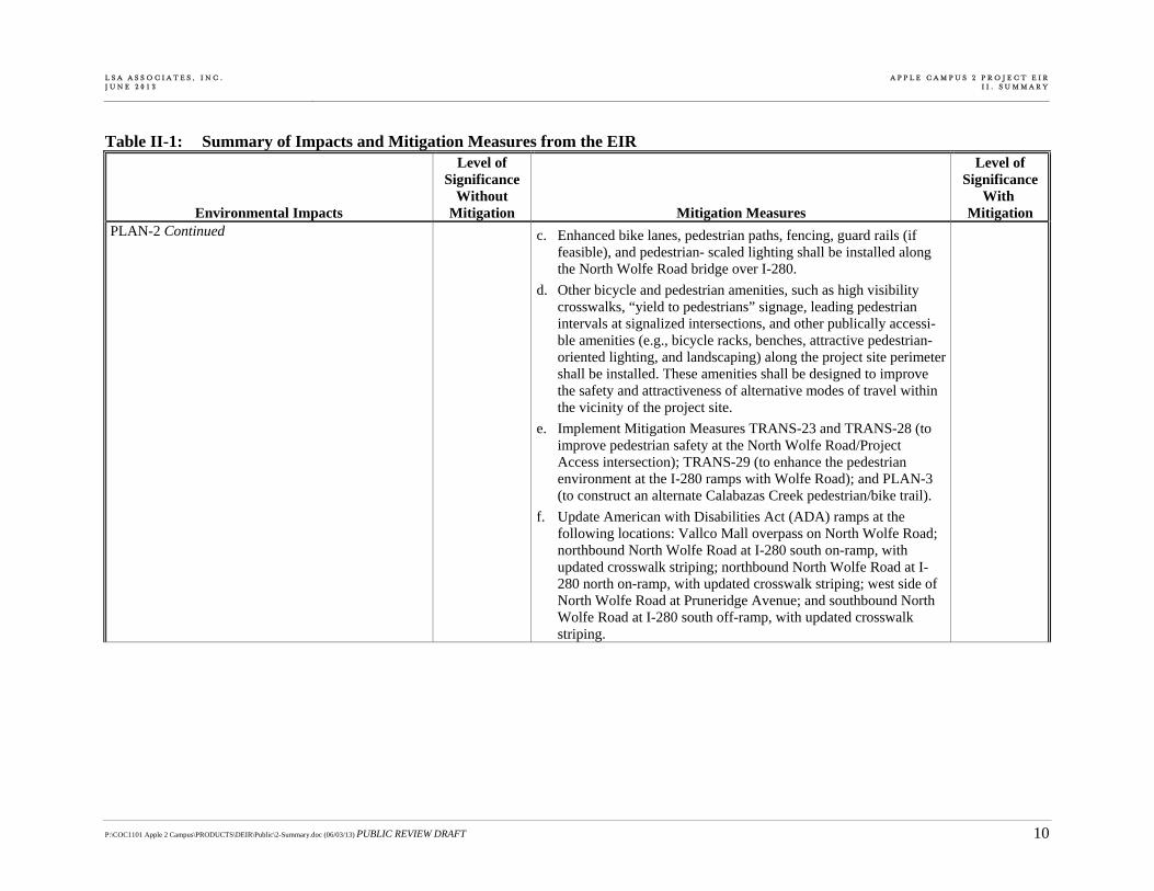
PLAN-2 Continued c. Enhanced bike lanes, pedestrian paths, fencing, guard rails (if feasible), and pedestrian- scaled lighting shall be installed along the North Wolfe Road bridge over I-280.
d. Other bicycle and pedestrian amenities, such as high visibility crosswalks, “yield to pedestrians” signage, leading pedestrian intervals at signalized intersections, and other publically accessi-ble amenities (e.g., bicycle racks, benches, attractive pedestrian-oriented lighting, and landscaping) along the project site perimeter shall be installed. These amenities shall be designed to improve the safety and attractiveness of alternative modes of travel within the vicinity of the project site.
e. Implement Mitigation Measures TRANS-23 and TRANS-28 (to improve pedestrian safety at the North Wolfe Road/Project Access intersection); TRANS-29 (to enhance the pedestrian environment at the I-280 ramps with Wolfe Road); and PLAN-3 (to construct an alternate Calabazas Creek pedestrian/bike trail).
f. Update American with Disabilities Act (ADA) ramps at the following locations: Vallco Mall overpass on North Wolfe Road; northbound North Wolfe Road at I-280 south on-ramp, with updated crosswalk striping; northbound North Wolfe Road at I-280 north on-ramp, with updated crosswalk striping; west side of North Wolfe Road at Pruneridge Avenue; and southbound North Wolfe Road at I-280 south off-ramp, with updated crosswalk striping.
L S A A S S O C I A T E S , I N C . J U N E 2 0 1 3
A P P L E C A M P U S 2 P R O J E C T E I RI I . S U M M A R Y
P:\COC1101 Apple 2 Campus\PRODUCTS\DEIR\Public\2-Summary.doc (06/03/13) PUBLIC REVIEW DRAFT 11
Table II-1: Summary of Impacts and Mitigation Measures from the EIR
Environmental Impacts
Level of Significance
Without Mitigation Mitigation Measures
Level of Significance
With Mitigation
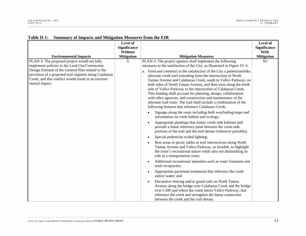
PLAN-3: The proposed project would not fully implement policies in the Land Use/Community Design Element of the General Plan related to the provision of a proposed trail segment along Calabazas Creek, and this conflict would result in an environ-mental impact.
S PLAN-3: The project sponsor shall implement the following measures to the satisfaction of the City, as illustrated in Figure IV-3:
a. Fund and construct to the satisfaction of the City a pedestrian/bike alternate creek trail extending from the intersection of North Tantau Avenue and Calabazas Creek, south to Vallco Parkway, on both sides of North Tantau Avenue, and then west along the north side of Vallco Parkway to the intersection of Calabazas Creek. This funding shall account for planning, design, collaboration with other agencies, and construction and maintenance of the alternate trail route. The trail shall include a combination of the following features that reference Calabazas Creek:
Signage along the route including both wayfinding/maps and information on creek habitat and ecology;
Appropriate plantings that mimic creek-side habitats and provide a linear reference point between the creek-side portions of the trail and the trail detour (wherever possible);
Special pedestrian scaled lighting;
Rest areas or picnic tables at trail intersections along North Tantau Avenue and Vallco Parkway, as feasible, to highlight the route’s recreational nature while also not diminishing its role as a transportation route;
Additional recreational amenities such as water fountains and trash receptacles;
Appropriate pavement treatments that reference the creek and/or water; and
Decorative fencing and/or guard rails on North Tantau Avenue along the bridge over Calabazas Creek and the bridge over I-280 and where the creek meets Vallco Parkway, that reference the creek and strengthen the linear connection between the creek and the trail detour.
SU

L S A A S S O C I A T E S , I N C . J U N E 2 0 1 3
A P P L E C A M P U S 2 P R O J E C T E I RI I . S U M M A R Y
P:\COC1101 Apple 2 Campus\PRODUCTS\DEIR\Public\2-Summary.doc (06/03/13) PUBLIC REVIEW DRAFT 12
Table II-1: Summary of Impacts and Mitigation Measures from the EIR
Environmental Impacts
Level of Significance
Without Mitigation Mitigation Measures
Level of Significance
With Mitigation
PLAN-3 Continued b. Partially fund, in the sum of $250,000, a study of a full Class I separated trail, where rights-of-way are adequate, along the drainage channel that runs parallel to southbound I-280 between North De Anza Boulevard and Calabazas Creek, and then south along the western bank of Calabazas Creek to Vallco Parkway. The study would only assess the feasibility of such a trail in the general area. If the City determines such a trail is feasible and determines to carry out the project, the trail would be subject to further environmental review and subsequent approvals. The potential future trail would connect to the project-related bicycle lane improvements on North Tantau Avenue and Vallco Parkway. The east-west connection would be publicly-accessible and would be used for commuting and recreation.
PLAN-4: The proposed project would not be consistent with the identification of the Glen-denning Barn as a Historic Site in the General Plan.
S PLAN-4: Implement Mitigation Measure CULT-1. LTS
PLAN-5: The proposed project would not fully implement several provisions of the Circulation Element of the General Plan related to the provision of trails, and the provision of bike and pedestrian access, and these conflicts would result in an environmental impact.
S PLAN-5: Implement Mitigation Measures PLAN-2 and PLAN-3. SU
PLAN-6: The proposed project would not fully implement provisions of the Environmental Resources/Sustainability Element of the General Plan related to the provision of trails and the provision of bike and pedestrian access, and these conflicts would result in an environ-mental impact.
S PLAN-6: Implement Mitigation Measures PLAN-2 and PLAN-3. SU

L S A A S S O C I A T E S , I N C . J U N E 2 0 1 3
A P P L E C A M P U S 2 P R O J E C T E I RI I . S U M M A R Y
P:\COC1101 Apple 2 Campus\PRODUCTS\DEIR\Public\2-Summary.doc (06/03/13) PUBLIC REVIEW DRAFT 13
Table II-1: Summary of Impacts and Mitigation Measures from the EIR
Environmental Impacts
Level of Significance
Without Mitigation Mitigation Measures
Level of Significance
With Mitigation
A. LAND USE LU-1: The proposed project would not be fully consistent with applicable land use plans and policies adopted for the purpose of avoiding or mitigating an environmental effect.
S LU-1: Implement Mitigation Measures PLAN-1, PLAN-2, PLAN-3, and CULT-1.
SU
B. AESTHETICS There are no significant Aesthetics impacts. C. POPULATION, EMPLOYMENT, AND HOUSING There are no significant Population, Employment, or Housing impacts. D. BIOLOGICAL RESOURCES BIO-1: The proposed project may result in the destruction or abandonment of nests occupied by special-status or non-special-status bird species that are protected under the Migratory Bird Treaty Act and Fish and Game Code.
S BIO-1: A qualified biologist shall conduct surveys prior to tree pruning, tree removal, transplantation, ground disturbing activities, or construction activities on the site to locate active nests containing either viable eggs or young birds. Preconstruction surveys are not required for tree removal, tree pruning, or construction activities outside the nesting period. If construction would occur during the nesting season (February 1 to August 31), preconstruction surveys shall be conducted no more than 14 days prior to the start of pruning, construction, or ground disturbing activities. Preconstruction surveys shall be repeated at 14-day intervals until construction has been initiated in the area after which surveys can be stopped. Locations of active nests containing viable eggs or young birds shall be described and protective measures implemented until the nests no longer contain eggs or young birds. Protective measures shall include establishment of clearly delineated exclusion zones (i.e., demarcated by uniquely identifiable fencing, such as orange construction fencing or equiva-lent) around each nest site as determined by a qualified wildlife biologist, taking into account the species of birds nesting on-site and their tolerance for disturbance. In general, exclusion zones shall be a minimum of 300 feet from the drip line of the nest tree or nest for raptors and 50 feet for passerines and other species. The active nest sites within an exclusion zone shall be monitored on a weekly basis throughout the nesting season to identify signs of disturbance or to determine if each nest no longer contains eggs or young birds.
LTS
L S A A S S O C I A T E S , I N C . J U N E 2 0 1 3
A P P L E C A M P U S 2 P R O J E C T E I RI I . S U M M A R Y
P:\COC1101 Apple 2 Campus\PRODUCTS\DEIR\Public\2-Summary.doc (06/03/13) PUBLIC REVIEW DRAFT 14
Table II-1: Summary of Impacts and Mitigation Measures from the EIR
Environmental Impacts
Level of Significance
Without Mitigation Mitigation Measures
Level of Significance
With Mitigation
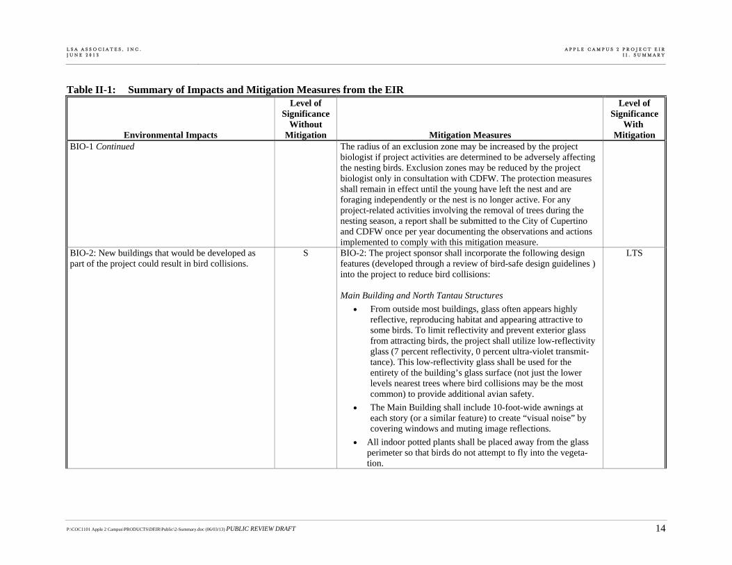
BIO-1 Continued The radius of an exclusion zone may be increased by the project biologist if project activities are determined to be adversely affecting the nesting birds. Exclusion zones may be reduced by the project biologist only in consultation with CDFW. The protection measures shall remain in effect until the young have left the nest and are foraging independently or the nest is no longer active. For any project-related activities involving the removal of trees during the nesting season, a report shall be submitted to the City of Cupertino and CDFW once per year documenting the observations and actions implemented to comply with this mitigation measure.
BIO-2: New buildings that would be developed as part of the project could result in bird collisions.
S BIO-2: The project sponsor shall incorporate the following design features (developed through a review of bird-safe design guidelines ) into the project to reduce bird collisions: Main Building and North Tantau Structures
From outside most buildings, glass often appears highly reflective, reproducing habitat and appearing attractive to some birds. To limit reflectivity and prevent exterior glass from attracting birds, the project shall utilize low-reflectivity glass (7 percent reflectivity, 0 percent ultra-violet transmit-tance). This low-reflectivity glass shall be used for the entirety of the building’s glass surface (not just the lower levels nearest trees where bird collisions may be the most common) to provide additional avian safety.
The Main Building shall include 10-foot-wide awnings at each story (or a similar feature) to create “visual noise” by covering windows and muting image reflections.
All indoor potted plants shall be placed away from the glass perimeter so that birds do not attempt to fly into the vegeta-tion.
LTS
L S A A S S O C I A T E S , I N C . J U N E 2 0 1 3
A P P L E C A M P U S 2 P R O J E C T E I RI I . S U M M A R Y
P:\COC1101 Apple 2 Campus\PRODUCTS\DEIR\Public\2-Summary.doc (06/03/13) PUBLIC REVIEW DRAFT 15
Table II-1: Summary of Impacts and Mitigation Measures from the EIR
Environmental Impacts
Level of Significance
Without Mitigation Mitigation Measures
Level of Significance
With Mitigation
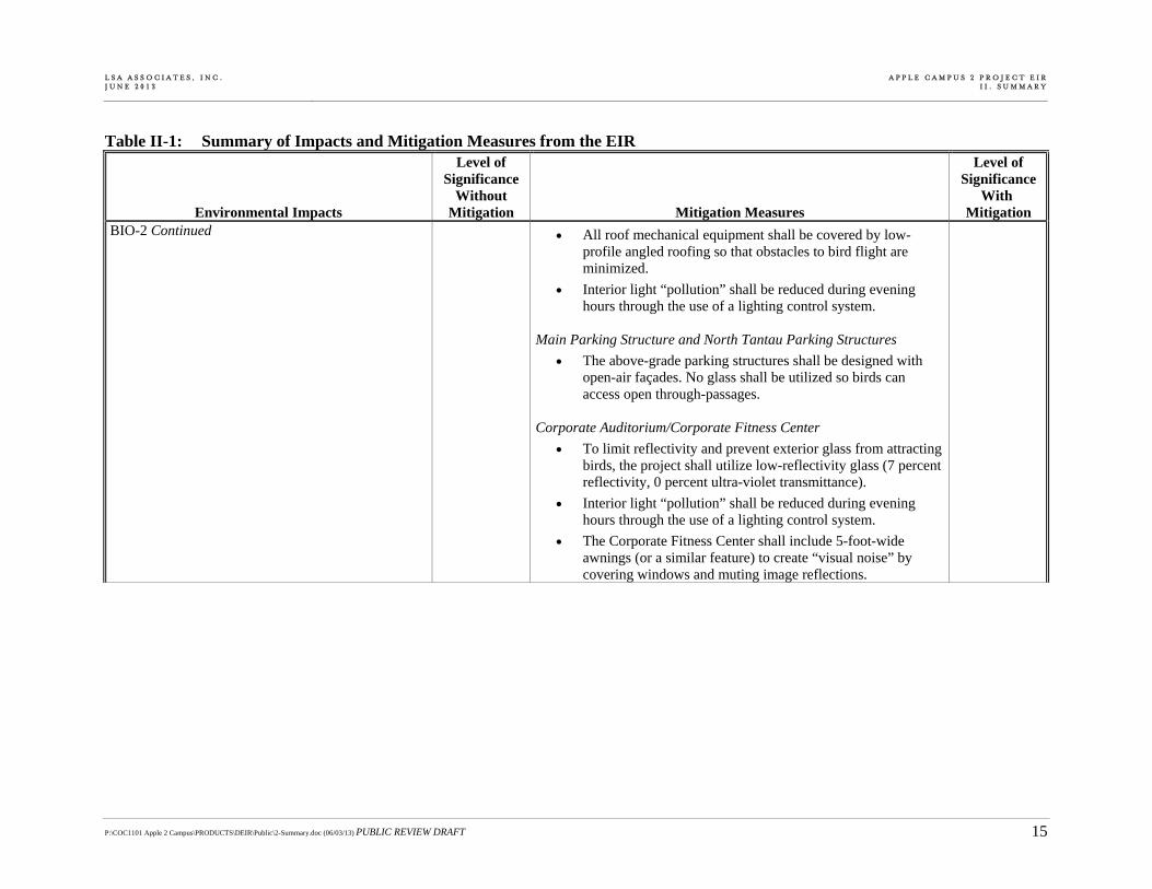
BIO-2 Continued All roof mechanical equipment shall be covered by low-profile angled roofing so that obstacles to bird flight are minimized.
Interior light “pollution” shall be reduced during evening hours through the use of a lighting control system.
Main Parking Structure and North Tantau Parking Structures
The above-grade parking structures shall be designed with open-air façades. No glass shall be utilized so birds can access open through-passages.
Corporate Auditorium/Corporate Fitness Center
To limit reflectivity and prevent exterior glass from attracting birds, the project shall utilize low-reflectivity glass (7 percent reflectivity, 0 percent ultra-violet transmittance).
Interior light “pollution” shall be reduced during evening hours through the use of a lighting control system.
The Corporate Fitness Center shall include 5-foot-wide awnings (or a similar feature) to create “visual noise” by covering windows and muting image reflections.

L S A A S S O C I A T E S , I N C . J U N E 2 0 1 3
A P P L E C A M P U S 2 P R O J E C T E I RI I . S U M M A R Y
P:\COC1101 Apple 2 Campus\PRODUCTS\DEIR\Public\2-Summary.doc (06/03/13) PUBLIC REVIEW DRAFT 16
Table II-1: Summary of Impacts and Mitigation Measures from the EIR
Environmental Impacts
Level of Significance
Without Mitigation Mitigation Measures
Level of Significance
With Mitigation
BIO-3: The proposed project would result in the removal of trees that are protected under the City of Cupertino’s Tree Protection Ordinance, and could thus conflict with a local policy or ordinance protecting biological resources.
S BIO-3: Replacement/compensation of all protected trees shall be undertaken in accordance with the Review of the Consolidated Arborist Report for the Apple Campus 2 Project and City Municipal Code requirements, prior to the initiation of construction. Recommen-dations noted within the Review of the Consolidated Arborist Report for the Apple Campus 2 Project, as modified by the Adjustments to Response to the Review of the Consolidated Arborist Report per EIR Plan Revision and A Review of the Trees Recommended for Trans-plant at the Apple Campus 2 Project shall be implemented to the satisfaction of the Community Development Director. Protected trees that are damaged or removed during construction or roadway improvements shall be subject to replacement/compensation accord-ing to the City’s tree protection ordinance. However, replacement for removed trees subject to the City’s Protected Tree Ordinance shall be consistent with the requirements of Chapter 14.18 of the Protected Tree Ordinance. Trees that have been identified as being suitable for transplantation shall be relocated in accordance with the Tree Transplant Schedule approved by the Community Development Director.
LTS
E. CULTURAL RESOURCES CULT-1: The project would relocate the Glendenning Barn, a designated Historic Site under the City of Cupertino General Plan and a historical resource under CEQA.
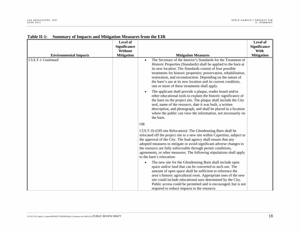
S CULT-1a (On-site Relocation): The Glendenning Barn shall be relocated to one of the following two sites within the Apple Campus 2 project site, subject to the approval of the City: 1) to the northeast of the Corporate Fitness Center, south of East Homestead Road or 2) at the proposed eastern termination of Pruneridge Avenue, near The Hamptons. The barn shall not be relocated to the second potential relocation site identified by Apple, to the west of the Central Plant, near the southwestern property line of the project site. This site is unacceptable to the City because it would be difficult to allow for the barn to be visible from a public right-of-way. The lead agency shall ensure that any adopted measures to mitigate or avoid significant adverse changes to the resource are fully enforceable through permit conditions, agreements, or other measures. The following stipulations shall apply to the barn’s on-site relocation:
LTS

L S A A S S O C I A T E S , I N C . J U N E 2 0 1 3
A P P L E C A M P U S 2 P R O J E C T E I RI I . S U M M A R Y
P:\COC1101 Apple 2 Campus\PRODUCTS\DEIR\Public\2-Summary.doc (06/03/13) PUBLIC REVIEW DRAFT 17
Table II-1: Summary of Impacts and Mitigation Measures from the EIR
Environmental Impacts
Level of Significance
Without Mitigation Mitigation Measures
Level of Significance
With Mitigation
CULT-1 Continued The following character-defining architectural elements of the barn shall be substantially visible from a public right-of-way, per the discretion of City staff: 1) size/scale of barn; 2) board and batten siding (including windows, if possible); and 3) roofline.
The new site for the Glendenning Barn shall include open space and/or land that can be converted to such use. The amount of open space shall be sufficient to reference the area’s historic agricultural roots.
The Glendenning Barn shall be relocated by a qualified structure-moving company with experience moving historic buildings.
Relocation of the Glendenning Barn shall be overseen by a qualified historical architect. The architect shall ensure that the barn retains its significant character-defining features at its new location, including its form, proportion, structure, plan, style, and materials. The historian shall be responsible for documenting relocation of the barn from its current, historic site to its new site. Documentation shall include production of a report that includes photographic documenta-tion of the move and a historical context for the barn that describes the resource’s significance in local history. Copies of this documentation shall be offered to local libraries and local historical societies, and submitted to the Northwest Information Center at Sonoma State University.
L S A A S S O C I A T E S , I N C . J U N E 2 0 1 3
A P P L E C A M P U S 2 P R O J E C T E I RI I . S U M M A R Y
P:\COC1101 Apple 2 Campus\PRODUCTS\DEIR\Public\2-Summary.doc (06/03/13) PUBLIC REVIEW DRAFT 18
Table II-1: Summary of Impacts and Mitigation Measures from the EIR
Environmental Impacts
Level of Significance
Without Mitigation Mitigation Measures
Level of Significance
With Mitigation
CULT-1 Continued The Secretary of the Interior’s Standards for the Treatment of Historic Properties (Standards) shall be applied to the barn at its new location. The Standards consist of four possible treatments for historic properties: preservation, rehabilitation, restoration, and reconstruction. Depending on the nature of the barn’s use at its new location and its current condition, one or more of these treatments shall apply.
The applicant shall provide a plaque, reader board and/or other educational tools to explain the historic significance of the barn on the project site. The plaque shall include the City seal, name of the resource, date it was built, a written description, and photograph, and shall be placed in a location where the public can view the information, not necessarily on the barn.
OR
CULT-1b (Off-site Relocation): The Glendenning Barn shall be relocated off the project site to a new site within Cupertino, subject to the approval of the City. The lead agency shall ensure that any adopted measures to mitigate or avoid significant adverse changes to the resource are fully enforceable through permit conditions, agreements, or other measures. The following stipulations shall apply to the barn’s relocation:
The new site for the Glendenning Barn shall include open space and/or land that can be converted to such use. The amount of open space shall be sufficient to reference the area’s historic agricultural roots. Appropriate uses of the new site could include educational uses determined by the City. Public access could be permitted and is encouraged, but is not required to reduce impacts to the resource.

L S A A S S O C I A T E S , I N C . J U N E 2 0 1 3
A P P L E C A M P U S 2 P R O J E C T E I RI I . S U M M A R Y
P:\COC1101 Apple 2 Campus\PRODUCTS\DEIR\Public\2-Summary.doc (06/03/13) PUBLIC REVIEW DRAFT 19
Table II-1: Summary of Impacts and Mitigation Measures from the EIR
Environmental Impacts
Level of Significance
Without Mitigation Mitigation Measures
Level of Significance
With Mitigation
CULT-1 Continued If located on private property, the following character-defining architectural elements of the barn shall be substan-tially visible from a public right-of-way or (if the barn and/or its surroundings are publicly-accessible) a public viewpoint, per the discretion of City staff: 1) size/scale of barn; 2) board and batten siding (including windows, if possible); and 3) roofline.
The Glendenning Barn shall be relocated by a qualified structure-moving company with experience moving historic buildings.
Relocation of the Glendenning Barn shall be overseen by a qualified historical architect. The architect shall ensure that the barn retains its significant character-defining features at its new location, including its form, proportion, structure, plan, style, and materials. The historian shall be responsible for documenting relocation of the barn from its current, historic site to its new site. Documentation shall include production of a report that includes photographic documenta-tion of the move and a historical context for the barn that describes the resource’s significance in local history. Copies of this documentation shall be offered to local libraries and local historical societies, and submitted to the Northwest Information Center at Sonoma State University.
The Secretary of the Interior’s Standards for the Treatment of Historic Properties (Standards) shall be applied to the barn at its new location. The Standards consist of four possible treatments for historic properties: preservation, rehabilitation, restoration, and reconstruction. Depending on the nature of the barn’s use at its new location and its current condition, one or more of these treatments shall apply.
L S A A S S O C I A T E S , I N C . J U N E 2 0 1 3
A P P L E C A M P U S 2 P R O J E C T E I RI I . S U M M A R Y
P:\COC1101 Apple 2 Campus\PRODUCTS\DEIR\Public\2-Summary.doc (06/03/13) PUBLIC REVIEW DRAFT 20
Table II-1: Summary of Impacts and Mitigation Measures from the EIR
Environmental Impacts
Level of Significance
Without Mitigation Mitigation Measures
Level of Significance
With Mitigation
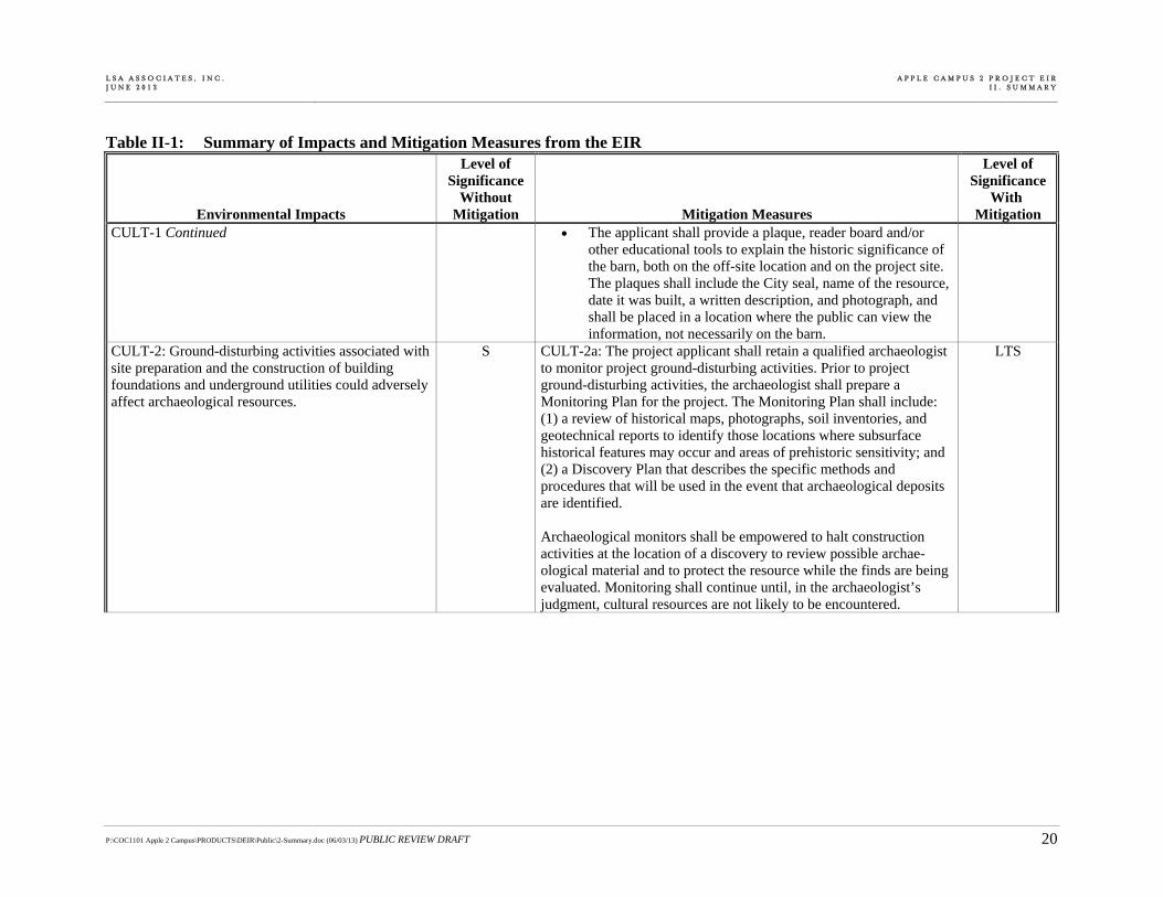
CULT-1 Continued The applicant shall provide a plaque, reader board and/or other educational tools to explain the historic significance of the barn, both on the off-site location and on the project site. The plaques shall include the City seal, name of the resource, date it was built, a written description, and photograph, and shall be placed in a location where the public can view the information, not necessarily on the barn.
CULT-2: Ground-disturbing activities associated with site preparation and the construction of building foundations and underground utilities could adversely affect archaeological resources.
S CULT-2a: The project applicant shall retain a qualified archaeologist to monitor project ground-disturbing activities. Prior to project ground-disturbing activities, the archaeologist shall prepare a Monitoring Plan for the project. The Monitoring Plan shall include: (1) a review of historical maps, photographs, soil inventories, and geotechnical reports to identify those locations where subsurface historical features may occur and areas of prehistoric sensitivity; and (2) a Discovery Plan that describes the specific methods and procedures that will be used in the event that archaeological deposits are identified. Archaeological monitors shall be empowered to halt construction activities at the location of a discovery to review possible archae-ological material and to protect the resource while the finds are being evaluated. Monitoring shall continue until, in the archaeologist’s judgment, cultural resources are not likely to be encountered.
LTS

L S A A S S O C I A T E S , I N C . J U N E 2 0 1 3
A P P L E C A M P U S 2 P R O J E C T E I RI I . S U M M A R Y
P:\COC1101 Apple 2 Campus\PRODUCTS\DEIR\Public\2-Summary.doc (06/03/13) PUBLIC REVIEW DRAFT 21
Table II-1: Summary of Impacts and Mitigation Measures from the EIR
Environmental Impacts
Level of Significance
Without Mitigation Mitigation Measures
Level of Significance
With Mitigation
CULT-2 Continued If deposits of prehistoric or historical archaeological materials are encountered during project activities, all work within 25 feet of the discovery shall be redirected until the archaeologist assesses the finds, consults with agencies as appropriate, and makes recommenda-tions for the treatment of the discovery. If avoidance of the archae-ological deposit is not feasible, the archaeological deposits shall be evaluated for their eligibility for listing in the California Register of Historical Resources. If the deposits are not eligible, mitigation is not necessary. If the deposits are eligible, adverse effects on the deposits shall be mitigated. Mitigation may include excavation of the archae-ological deposit in accordance with a data recovery plan (see CEQA Guidelines Section 15126.4(b)(3)(C)) and standard archaeological field methods and procedures; laboratory and technical analyses of recovered archaeological materials; preparation of a report detailing the methods, findings, and significance of the archaeological site and associated materials; and accessioning of archaeological materials and a technical data recovery report at a curation facility. Upon completion of the assessment, the archaeologist shall prepare a report to document the methods and results of the assessment. The report shall be submitted to the City of Cupertino and the Northwest Information Center at Sonoma State University upon completion of the resource assessment.

L S A A S S O C I A T E S , I N C . J U N E 2 0 1 3
A P P L E C A M P U S 2 P R O J E C T E I RI I . S U M M A R Y
P:\COC1101 Apple 2 Campus\PRODUCTS\DEIR\Public\2-Summary.doc (06/03/13) PUBLIC REVIEW DRAFT 22
Table II-1: Summary of Impacts and Mitigation Measures from the EIR
Environmental Impacts
Level of Significance
Without Mitigation Mitigation Measures
Level of Significance
With Mitigation
CULT-2 Continued CULT-2b: If archaeological deposits are encountered during project subsurface construction when an archaeological monitor is not present, all ground-disturbing activities within 25 feet shall be redirected and a qualified archaeologist contacted to assess the situation, consult with agencies as appropriate, and make recommen-dations for the treatment of the discovery. The project applicant shall inform its contractor(s) of the sensitivity of the project area for archaeological deposits. The City shall verify that the following directive has been included in the appropriate contract documents:
“If prehistoric or historical archaeological deposits are discovered during project activities, all work within 25 feet of the discovery shall be redirected and a qualified archaeologist contacted to assess the situation, consult with agencies as appropriate, and make recommendations regarding the treatment of the discovery. Project personnel shall not collect or move any archaeological materials or human remains and associated materials. Archae-ological resources can include flaked-stone tools (e.g., projectile points, knives, choppers) or obsidian, chert, basalt, or quartzite toolmaking debris; bone tools; culturally darkened soil (i.e., midden soil often containing heat-affected rock, ash and charcoal, shellfish remains, faunal bones, and cultural materials); and stone-milling equipment (e.g., mortars, pestles, handstones). Prehistoric archaeological sites often contain human remains.”
Adverse effects to archaeological deposits shall be treated in accord-ance with Mitigation Measure CULT-2a.

L S A A S S O C I A T E S , I N C . J U N E 2 0 1 3
A P P L E C A M P U S 2 P R O J E C T E I RI I . S U M M A R Y
P:\COC1101 Apple 2 Campus\PRODUCTS\DEIR\Public\2-Summary.doc (06/03/13) PUBLIC REVIEW DRAFT 23
Table II-1: Summary of Impacts and Mitigation Measures from the EIR
Environmental Impacts
Level of Significance
Without Mitigation Mitigation Measures
Level of Significance
With Mitigation
CULT-3: Ground-disturbing activities associated with site preparation and the construction of building foundations and underground utilities could adversely affect paleontological resources.
S CULT-3: Should paleontological resources be encountered during project subsurface construction activities, all ground-disturbing activities within 25 feet shall be redirected and a qualified paleon-tologist contacted to assess the situation, consult with agencies as appropriate, and make recommendations for the treatment of the discovery. If found to be significant, and project activities cannot avoid the paleontological resources, adverse effects to paleontological resources shall be mitigated. Mitigation may include monitoring, recording the fossil locality, data recovery and analysis, a final report, and accessioning the fossil material and technical report to a paleon-tological repository. Public educational outreach may also be appro-priate. Upon completion of the assessment, a report documenting methods, findings, and recommendations shall be prepared and submitted to the City of Cupertino for review, and (if paleontological materials are recovered) a paleontological repository, such as the University of California Museum of Paleontology. The project applicant shall inform its contractor(s) of the sensitivity of the project area for paleontological resources. The City shall verify that the following directive has been included in the appropriate contract documents:
“The subsurface of the construction site may be sensitive for paleontological resources. If paleontological resources are encountered during project subsurface construction and a paleon-tologist is not on-site, all ground-disturbing activities within 25 feet shall be redirected and a qualified paleontologist contacted to assess the situation, consult with agencies as appropriate, and make recommendations for the treatment of the discovery. Project personnel shall not collect or move any paleontological materials.
LTS
L S A A S S O C I A T E S , I N C . J U N E 2 0 1 3
A P P L E C A M P U S 2 P R O J E C T E I RI I . S U M M A R Y
P:\COC1101 Apple 2 Campus\PRODUCTS\DEIR\Public\2-Summary.doc (06/03/13) PUBLIC REVIEW DRAFT 24
Table II-1: Summary of Impacts and Mitigation Measures from the EIR
Environmental Impacts
Level of Significance
Without Mitigation Mitigation Measures
Level of Significance
With Mitigation
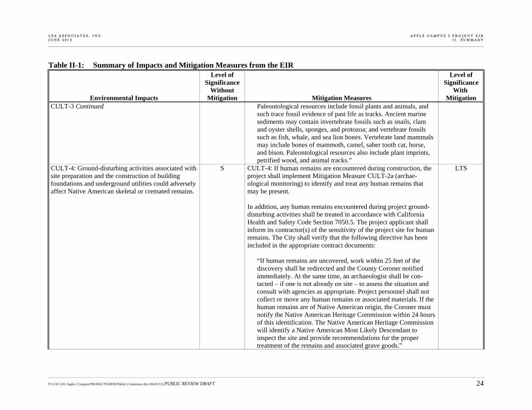
CULT-3 Continued Paleontological resources include fossil plants and animals, and such trace fossil evidence of past life as tracks. Ancient marine sediments may contain invertebrate fossils such as snails, clam and oyster shells, sponges, and protozoa; and vertebrate fossils such as fish, whale, and sea lion bones. Vertebrate land mammals may include bones of mammoth, camel, saber tooth cat, horse, and bison. Paleontological resources also include plant imprints, petrified wood, and animal tracks.”
CULT-4: Ground-disturbing activities associated with site preparation and the construction of building foundations and underground utilities could adversely affect Native American skeletal or cremated remains.
S CULT-4: If human remains are encountered during construction, the project shall implement Mitigation Measure CULT-2a (archae-ological monitoring) to identify and treat any human remains that may be present. In addition, any human remains encountered during project ground-disturbing activities shall be treated in accordance with California Health and Safety Code Section 7050.5. The project applicant shall inform its contractor(s) of the sensitivity of the project site for human remains. The City shall verify that the following directive has been included in the appropriate contract documents:
“If human remains are uncovered, work within 25 feet of the discovery shall be redirected and the County Coroner notified immediately. At the same time, an archaeologist shall be con-tacted – if one is not already on site – to assess the situation and consult with agencies as appropriate. Project personnel shall not collect or move any human remains or associated materials. If the human remains are of Native American origin, the Coroner must notify the Native American Heritage Commission within 24 hours of this identification. The Native American Heritage Commission will identify a Native American Most Likely Descendant to inspect the site and provide recommendations for the proper treatment of the remains and associated grave goods.”
LTS

L S A A S S O C I A T E S , I N C . J U N E 2 0 1 3
A P P L E C A M P U S 2 P R O J E C T E I RI I . S U M M A R Y
P:\COC1101 Apple 2 Campus\PRODUCTS\DEIR\Public\2-Summary.doc (06/03/13) PUBLIC REVIEW DRAFT 25
Table II-1: Summary of Impacts and Mitigation Measures from the EIR
Environmental Impacts
Level of Significance
Without Mitigation Mitigation Measures
Level of Significance
With Mitigation
F. GEOLOGY, SEISMICITY, AND SOILS GEO-1: Occupants of the development proposed as part of the project would be subject to seismic hazards.
S GEO-1: Prior to the issuance of any site-specific grading or building permits, a design-level geotechnical report shall be prepared and submitted to the City of Cupertino Building Department for review and approval and in accordance with adopted City standards. The structural designs shall adhere to the 2010 California Building Code (CBC) or the appropriate building code, as adopted by the City of Cupertino. Examples of the kinds of measures that would typically be used to meet these requirements include pile-supported foundations, use of pre-stressed concrete materials, slab reinforcement, compac-tion specifications, drainage requirements, use of control joints, and appropriate safety factors. The report shall identify specific building techniques appropriate for minimizing damage from seismic events, including liquefaction and lateral spreading. In addition, the following requirement for the geotechnical and soils report shall be met:
The seismic hazard analysis presented in the geotechnical report shall include an evaluation of liquefaction hazards in the Calabazas Creek area, and shall conform to the California Division of Mines and Geology recommendations presented in the Guidelines for Evaluating and Mitigating Seismic Hazards in California.
Design review for the project shall include evaluation of fixtures, furnishings, and fasteners with the intent of minimizing collateral injuries to building occupants from falling fixtures or furnishings during the course of a violent seismic event.
LTS
L S A A S S O C I A T E S , I N C . J U N E 2 0 1 3
A P P L E C A M P U S 2 P R O J E C T E I RI I . S U M M A R Y
P:\COC1101 Apple 2 Campus\PRODUCTS\DEIR\Public\2-Summary.doc (06/03/13) PUBLIC REVIEW DRAFT 26
Table II-1: Summary of Impacts and Mitigation Measures from the EIR
Environmental Impacts
Level of Significance
Without Mitigation Mitigation Measures
Level of Significance
With Mitigation
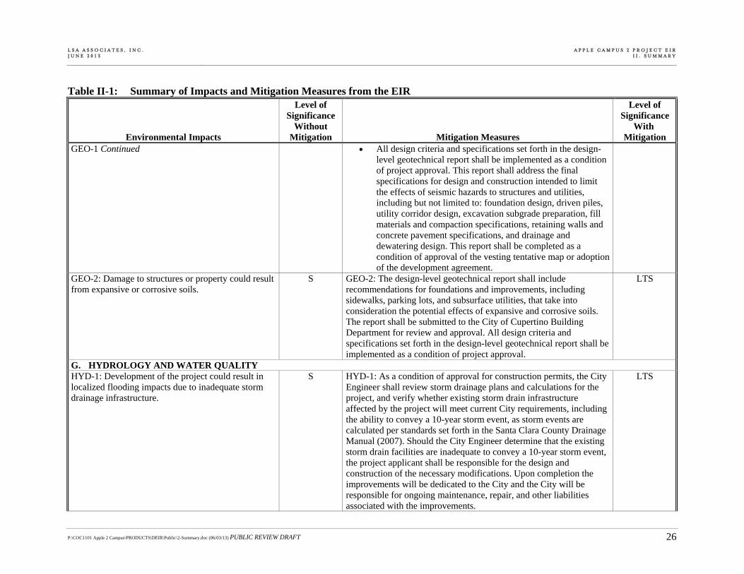
GEO-1 Continued All design criteria and specifications set forth in the design-level geotechnical report shall be implemented as a condition of project approval. This report shall address the final specifications for design and construction intended to limit the effects of seismic hazards to structures and utilities, including but not limited to: foundation design, driven piles, utility corridor design, excavation subgrade preparation, fill materials and compaction specifications, retaining walls and concrete pavement specifications, and drainage and dewatering design. This report shall be completed as a condition of approval of the vesting tentative map or adoption of the development agreement.
GEO-2: Damage to structures or property could result from expansive or corrosive soils.
S GEO-2: The design-level geotechnical report shall include recommendations for foundations and improvements, including sidewalks, parking lots, and subsurface utilities, that take into consideration the potential effects of expansive and corrosive soils. The report shall be submitted to the City of Cupertino Building Department for review and approval. All design criteria and specifications set forth in the design-level geotechnical report shall be implemented as a condition of project approval.
LTS
G. HYDROLOGY AND WATER QUALITY HYD-1: Development of the project could result in localized flooding impacts due to inadequate storm drainage infrastructure.
S HYD-1: As a condition of approval for construction permits, the City Engineer shall review storm drainage plans and calculations for the project, and verify whether existing storm drain infrastructure affected by the project will meet current City requirements, including the ability to convey a 10-year storm event, as storm events are calculated per standards set forth in the Santa Clara County Drainage Manual (2007). Should the City Engineer determine that the existing storm drain facilities are inadequate to convey a 10-year storm event, the project applicant shall be responsible for the design and construction of the necessary modifications. Upon completion the improvements will be dedicated to the City and the City will be responsible for ongoing maintenance, repair, and other liabilities associated with the improvements.
LTS
L S A A S S O C I A T E S , I N C . J U N E 2 0 1 3
A P P L E C A M P U S 2 P R O J E C T E I RI I . S U M M A R Y
P:\COC1101 Apple 2 Campus\PRODUCTS\DEIR\Public\2-Summary.doc (06/03/13) PUBLIC REVIEW DRAFT 27
Table II-1: Summary of Impacts and Mitigation Measures from the EIR
Environmental Impacts
Level of Significance
Without Mitigation Mitigation Measures
Level of Significance
With Mitigation
H. HAZARDS AND HAZARDOUS MATERIALS HAZ-1: Upset and accidents involving hazardous materials releases and transport and use during construction activities could result in adverse effects to public health or the environ-ment.
S HAZ-1a: The contractor(s) shall designate storage areas suitable for material delivery, storage, and waste collection. These locations must be as far away from catch basins, gutters, drainage courses, and Calabazas Creek as feasible. All hazardous materials and wastes used or generated during project site development activities shall be labeled and stored in accordance with applicable local, State, and federal regulations. In addition, an accurate up-to-date inventory, including Material Safety Data Sheets, shall be maintained on-site to assist emergency response personnel in the event of a hazardous materials incident. All maintenance and fueling of vehicles and equipment shall be performed in a designated, bermed area, or over a drip pan that will not allow runoff of spills. Vehicles and equipment shall be regularly checked and leaks shall be repaired promptly at an off-site location. Secondary containment shall be used to catch leaks or spills any time that vehicle or equipment fluids are dispensed, changed, or poured. Mitigation Measure HAZ-1b: Emergency preparedness and response procedures shall be developed by the contractor(s) for emergency notification in the event of an accidental spill or other hazardous materials emergency during project site preparation and development activities. These procedures shall include evacuation procedures, spill containment procedures, and required personal protective equipment, as appropriate, in responding to the emergency. The contractor(s) shall submit these procedures to the City of Cupertino for approval prior to demolition, site preparation, or development activities. Compliance with these mitigation measures may occur in coordina-tion with compliance with the Storm Water Pollution Prevention Plan and Best Management Practices required for the proposed project (see Section V.G, Hydrology and Water Quality, for additional detail).
LTS

L S A A S S O C I A T E S , I N C . J U N E 2 0 1 3
A P P L E C A M P U S 2 P R O J E C T E I RI I . S U M M A R Y
P:\COC1101 Apple 2 Campus\PRODUCTS\DEIR\Public\2-Summary.doc (06/03/13) PUBLIC REVIEW DRAFT 28
Table II-1: Summary of Impacts and Mitigation Measures from the EIR
Environmental Impacts
Level of Significance
Without Mitigation Mitigation Measures
Level of Significance
With Mitigation
HAZ-2: Exposure of construction workers and the public to existing or previously unknown contamination in soil and/or groundwater, other safety hazards encountered during site grading and excavation activities, or exposure to hazardous materials following project development could result in adverse health effects.
S HAZ-2a: Construction at the project site shall be conducted under a project-specific Environmental Site Management Plan (ESMP) that is prepared in consultation with the RWQCB. The purpose of the ESMP is to protect construction workers, the general public, the environ-ment, and future site occupants from subsurface hazardous materials previously identified at the project site and to address the possibility of encountering unknown contamination or hazards in the subsurface. The ESMP shall summarize soil and groundwater analytical data collected on the project site during past investigations; identify management options for excavated soil and groundwater, if contam-inated media are encountered during deep excavations; and identify monitoring, irrigation, or other wells requiring proper abandonment in compliance with local, State, and federal statutes and regulations. The ESMP shall include measures for identifying, testing, and managing soil and groundwater suspected of or known to contain hazardous materials. The ESMP shall: 1) provide procedures for evaluating, handling, storing, testing, and disposing of soil and groundwater during project excavation and dewatering activities, respectively; 2) describe required worker health and safety provisions for all workers potentially exposed to hazardous materials in accordance with State and federal worker safety regulations; and 3) designate personnel responsible for implementation of the ESMP.
LTS

L S A A S S O C I A T E S , I N C . J U N E 2 0 1 3
A P P L E C A M P U S 2 P R O J E C T E I RI I . S U M M A R Y
P:\COC1101 Apple 2 Campus\PRODUCTS\DEIR\Public\2-Summary.doc (06/03/13) PUBLIC REVIEW DRAFT 29
Table II-1: Summary of Impacts and Mitigation Measures from the EIR
Environmental Impacts
Level of Significance
Without Mitigation Mitigation Measures
Level of Significance
With Mitigation
HAZ-2 Continued HAZ-2b: For areas at the project site with potential residual VOCs in soil, soil gas, or groundwater that are planned for redevelopment with an overlying occupied building, a vapor intrusion assessment shall be performed by a licensed environmental professional. These areas include the northwestern corner of the site at the Hewlett-Packard Building 42 area and the 10400 North Tantau Avenue property. If the results of the vapor intrusion assessment indicate the potential for significant vapor intrusion into an occupied building, project design shall include vapor controls or source removal, as appropriate, in accordance with regulatory agency requirements. Soil vapor mitigations or controls could include passive venting and/or active venting. The vapor intrusion assessment and associated vapor controls or source removal can be incorporated into the ESMP (Mitigation Measure HAZ-2a).
HAZ-3: Demolition activities at the project site could result in exposure to hazardous building materials.
S HAZ-3: Hazardous building materials surveys shall be conducted by a qualified and licensed professional for all structures, not previously inspected or abated, proposed for demolition or renovation at the project site. ACM shall be included in the hazardous materials building surveys for buildings constructed prior to 1981. Lead-based paint shall be included in all hazardous material surveys. All loose and peeling lead-based paint and ACM shall be abated by certified contractor(s) in accordance with local, State, and federal requirements. All other hazardous materials, such as “universal wastes,” shall be removed from buildings prior to demolition in accordance with DOSH regulations. The completion of the abatement activities shall be documented by a qualified environmental professional(s) and submitted to the City of Cupertino prior to the issuance of construction and demolition permits.
LTS
HAZ-4: The proposed project involves hazardous or acutely hazardous materials within ¼-mile of a school.
S HAZ-4: Implement Mitigation Measures HAZ-1 and HAZ-2. LTS

L S A A S S O C I A T E S , I N C . J U N E 2 0 1 3
A P P L E C A M P U S 2 P R O J E C T E I RI I . S U M M A R Y
P:\COC1101 Apple 2 Campus\PRODUCTS\DEIR\Public\2-Summary.doc (06/03/13) PUBLIC REVIEW DRAFT 30
Table II-1: Summary of Impacts and Mitigation Measures from the EIR
Environmental Impacts
Level of Significance
Without Mitigation Mitigation Measures
Level of Significance
With Mitigation
I. TRANSPORTATION AND CIRCULATION TRANS-1: Under Existing plus Project Conditions, completion of the proposed project would cause intersection #21 Wolfe Road/I-280 Northbound Ramps to operate at an unacceptable level (change from LOS B to LOS E) during the AM peak hour based on City of Cupertino LOS standards.
S TRANS-1: As part of the project, the project sponsor would construct an additional westbound lane at intersection #21 Wolfe Road/I-280 Northbound Ramps to provide for dual left-turn and dual right-turn lanes. With the additional lane, the intersection would operate at acceptable LOS B (17.1 seconds) during the AM peak hour. However, the off-ramp intersection is under Caltrans jurisdiction. Therefore, neither the project sponsor nor the City of Cupertino can ensure the implementation of the proposed mitigation measure; thus the impact is considered significant and unavoidable.
SU
TRANS-2: Under Existing plus Project Conditions, completion of the proposed project would cause intersection #31 Tantau Avenue/Vallco Parkway to operate at an unacceptable level (change from LOS C to LOS E+) during the AM peak hour based on City of Cupertino LOS impact thresholds.
S TRANS-2: At intersection #31 Tantau Avenue/Vallco Parkway, the project sponsor shall construct an exclusive northbound through lane (for a total of one left-turn lane, one through lane, and one shared through/right-turn lane), and a receiving lane on the north side of the intersection which would improve intersection operations to acceptable LOS C (26.1 seconds). The proposed mitigation measure could have secondary impacts to the trees along the east side of Tantau Avenue. The roadway would need to be widened to the east, to provide for a bike lane to the right of the travel lane and the sidewalk adjacent to the bike lane. Second-ary impacts associated with the removal of trees that are protected under the City of Cupertino’s Tree Protection Ordinance could occur with the identified mitigation measure. Impacts BIO-1 and BIO-3 in Section V.D, Biological Resources in DEIR addresses these potential secondary impacts.
LTS

L S A A S S O C I A T E S , I N C . J U N E 2 0 1 3
A P P L E C A M P U S 2 P R O J E C T E I RI I . S U M M A R Y
P:\COC1101 Apple 2 Campus\PRODUCTS\DEIR\Public\2-Summary.doc (06/03/13) PUBLIC REVIEW DRAFT 31
Table II-1: Summary of Impacts and Mitigation Measures from the EIR
Environmental Impacts
Level of Significance
Without Mitigation Mitigation Measures
Level of Significance
With Mitigation
TRANS-3: Under Existing plus Project Conditions, completion of the proposed project would cause intersection #36 Stevens Creek Boulevard/Calvert Drive/I-280 Ramps (west) to operate at an unacceptable level (change from LOS D to LOS F) during the PM peak hour based on CMP guideline.
S TRANS-3: At intersection #36 Stevens Creek Boulevard/Calvert Drive/I-280 Ramps (west), the project sponsor shall construct an exclusive eastbound right-turn lane (for a total of three through lanes and one right-turn lane) and provide an eastbound right-turn overlap phase. This would improve intersection operations to acceptable LOS E+. To accommodate the added lane the existing buffer between the roadway and sidewalk would need to be eliminated and the sidewalk pushed closer to the existing fence on the south side of Stevens Creek Boulevard. This mitigation measure would also require relocation of an existing streetlight, fire hydrant, and utility pole. This intersection is a CMP intersection and is located within the City of Santa Clara. It is also under Caltrans jurisdiction. The project sponsor would be required to coordinate with the City of Santa Clara and Caltrans to construct the identified physical improvement at the Stevens Creek Boulevard/Calvert Drive/I-280 Ramp (west) intersec-tion. Since this intersection is outside of the City of Cupertino’s jurisdiction, the City cannot guarantee that the improvement would be constructed. For this reason the impact would remain significant and unavoidable.
SU
TRANS-4: Under Background Plus Project Conditions, completion of the proposed project would exacerbate unacceptable operations of intersection #5 De Anza Boulevard/Homestead Road during the PM peak hour based on City of Cupertino LOS impact thresholds.
S TRANS-4: At intersection #5 De Anza Boulevard/Homestead Road the project sponsor shall construct an exclusive southbound right-turn lane (for a total of two left-turn lanes, three through lanes, and one right-turn lane) which would improve intersection operations to LOS E+. Although still considered an unacceptable LOS based on Cupertino’s standards, this mitigation measure would improve operations over Background No Project Conditions. With the mitigation measure identified above, secondary impacts associated with the removal of trees could occur. Trees are protected under the City of Cupertino’s Tree Protection Ordinance. Impacts BIO-1 and BIO-3 in Section V.D, Biological Resources addresses these potential secondary impacts related to potential tree removal.
LTS

L S A A S S O C I A T E S , I N C . J U N E 2 0 1 3
A P P L E C A M P U S 2 P R O J E C T E I RI I . S U M M A R Y
P:\COC1101 Apple 2 Campus\PRODUCTS\DEIR\Public\2-Summary.doc (06/03/13) PUBLIC REVIEW DRAFT 32
Table II-1: Summary of Impacts and Mitigation Measures from the EIR
Environmental Impacts
Level of Significance
Without Mitigation Mitigation Measures
Level of Significance
With Mitigation
TRANS-5: Under Background plus Project Conditions, completion of the proposed project would cause intersection #21 Wolfe Road/I-280 Northbound Ramps to operate at an unacceptable level (change from LOS B to LOS E) during the AM peak hour based on City of Cupertino LOS impact thresholds.
S TRANS-5: At intersection #21 Wolfe Road/I-280 Northbound Ramps, the project sponsor shall implement Mitigation Measure TRANS-1 (provide dual left- and right-turn lanes on the off-ramp), which would improve intersection operations to acceptable LOS B (18.0 seconds). However, the off-ramp intersection is under Caltrans jurisdiction. Therefore, neither the applicant nor the City of Cupertino can ensure the implementation of the proposed mitigation measure; thus the impact is considered significant and unavoidable.
SU
TRANS-6: Under Background plus Project Conditions, completion of the proposed project would cause intersection #27 Tantau Avenue/Homestead Road to operate at an unacceptable level (change from LOS D+ to LOS E) during the AM peak hour based on City of Cupertino LOS impact thresholds.
S TRANS-6: At intersection #27 Tantau Avenue/Homestead Road the project sponsor shall construct an exclusive right-turn lane from eastbound Homestead Road to southbound Tantau Avenue (for a total of one eastbound left-turn lane, two eastbound through lanes, and one eastbound right-turn lane), which would improve intersection operations to acceptable LOS D- (52.6 seconds). With the mitigation measure identified above, secondary impacts associated with the removal of trees could occur. Trees are protected under the City of Cupertino’s Tree Protection Ordinance. Impacts BIO-1 and BIO-3 in Section V.D, Biological Resources addresses these potential secondary impacts related to potential tree removal.
LTS
TRANS-7: Under Background plus Project Conditions, completion of the proposed project would cause intersection #31 Tantau Avenue/Vallco Parkway to operate at an unacceptable level (change from LOS C to LOS E+) during the AM peak hour based on City of Cupertino LOS impact thresholds.
S TRANS-7: At intersection #31 Tantau Avenue/Vallco Parkway, the project sponsor shall implement Mitigation Measure TRANS-2 (add exclusive northbound through lane), which would improve intersection operations to acceptable LOS C (28.7 seconds).
LTS

L S A A S S O C I A T E S , I N C . J U N E 2 0 1 3
A P P L E C A M P U S 2 P R O J E C T E I RI I . S U M M A R Y
P:\COC1101 Apple 2 Campus\PRODUCTS\DEIR\Public\2-Summary.doc (06/03/13) PUBLIC REVIEW DRAFT 33
Table II-1: Summary of Impacts and Mitigation Measures from the EIR
Environmental Impacts
Level of Significance
Without Mitigation Mitigation Measures
Level of Significance
With Mitigation
TRANS-8: Under Background plus Project Conditions, completion of the proposed project would cause intersection #32 Tantau Avenue/Stevens Creek Boulevard to operate at an unacceptable level (change from LOS D to LOS E-) during the PM peak hour based on City of Cupertino LOS impact thresholds.
S TRANS-8: At intersection #32 Tantau Avenue/Stevens Creek Boulevard, the project sponsor shall construct a 100-foot exclusive southbound right-turn lane (for a total of two southbound left-turn lanes and one southbound right-turn lane), with associated improvements in the right-of-way, which would improve intersection operations to acceptable LOS D (46.8 seconds).
LTS
TRANS-9: Under Background plus Project Conditions, completion of the proposed project would exacerbate unacceptable operations of intersection #36 Stevens Creek Boulevard/Calvert Drive/I-280 Ramps (west) during the PM peak hour based on CMP guidelines.
S TRANS-9a: At intersection #36 Stevens Creek Boulevard/Calvert Drive/I-280 Ramps (west), the project sponsor shall implement Mitigation Measure TRANS-3 (add exclusive eastbound right-turn lane), which would improve intersection operations to 112.2 seconds (LOS F). However, the Stevens Creek Boulevard/Calvert Drive/I-280 Ramps (west) intersection would continue to operate unacceptably. Providing a second right-turn lane would improve intersection operations to LOS E with 63.0 seconds of delay. However, there are right-of-way constraints that render a second right-turn lane infeasible, since there would be less than 7 feet of right-of-way available between the fence and curb on the south side of Steven Creek after implementation of Mitigation Measure TRANS-3. At minimum, 11 feet of right-of-way are needed to accommodate a second right-turn lane.
SU
TRANS-9b: The project sponsor shall expand the TDM program to reduce the severity of the impact per the TDM Program Expansion subsection. Increasing the TDM participation and associated alternative mode share from 28 percent to 34 percent would improve operations to LOS F (142.8 seconds) without implementation of TRANS-3; however it would not reduce the impact to a less-than-significant level. A robust monitoring program has been identified in the TDM Program Expansion subsection and shall be required to ensure that this TDM program mitigation measure is implemented and that the required trip reduction is achieved. Details of the TDM program are discussed in the TDM Program Expansion subsection.

L S A A S S O C I A T E S , I N C . J U N E 2 0 1 3
A P P L E C A M P U S 2 P R O J E C T E I RI I . S U M M A R Y
P:\COC1101 Apple 2 Campus\PRODUCTS\DEIR\Public\2-Summary.doc (06/03/13) PUBLIC REVIEW DRAFT 34
Table II-1: Summary of Impacts and Mitigation Measures from the EIR
Environmental Impacts
Level of Significance
Without Mitigation Mitigation Measures
Level of Significance
With Mitigation
TRANS-10: Under Background plus Project Conditions, completion of the proposed project would cause operations of intersection #40 Stevens Creek Boulevard/Lawrence Expressway Ramps (east) to operate at an unacceptable level (change from LOS D to LOS F) during the AM peak hour based on CMP guidelines.
S TRANS-10: At intersection #40 Stevens Creek Boulevard/Lawrence Expressway (east) the project sponsor shall construct a northbound left-turn lane (for a total of two exclusive left-turn lanes, one shared left-turn/through lane, and shared through/right-turn lane) from northbound Lawrence Expressway to westbound Stevens Creek Boulevard. This mitigation would improve intersection operations to LOS D (49.7 seconds). This improvement is physically feasible; however, it would require the construction of a retaining wall and modifications to the eastbound approach to accommodate the additional left-turn lane. This intersection is a CMP intersection located within the City of Santa Clara. The project sponsor would be required to coordinate with VTA, City of Santa Clara, and other responsible agencies to construct the identified physical improvement at the Stevens Creek Boulevard/Lawrence Expressway Ramps (east) intersection. Since this intersection is outside of the City of Cupertino’s jurisdiction, the City cannot guarantee that the improvement would be constructed. For this reason the impact would remain significant and unavoidable.
SU
TRANS-11: Under Background plus Project Conditions, completion of the proposed project would cause operations of intersection #41 Lawrence Expressway/I-280 Southbound Ramps to operate at an unacceptable level (change from LOS E to LOS F) during the PM peak hour based on CMP guidelines.
S TRANS-11: At intersection #41 Lawrence Expressway/I-280 Southbound Ramps, the project sponsor shall construct an exclusive eastbound through lane (for a total of one shared left-turn/through lane, one through lane, and one right-turn lane), which would improve intersection operations to acceptable LOS E+ (56.9 seconds). The mitigation measure would require the construction of a new retaining wall along I-280, since Calvert Road would need to be curved to properly align with two receiving lanes at the on-ramp. There is existing right-of-way to accommodate this mitigation measure. However, the measure would require widening the existing bridge that crosses the creek running parallel to the west side of Lawrence Expressway. The widening would cause secondary impacts to the creek. Potential secondary impacts to the creek associated with widening the existing bridge as a traffic mitigation measure are addressed in Section V.D, Biological Resources.
SU

L S A A S S O C I A T E S , I N C . J U N E 2 0 1 3
A P P L E C A M P U S 2 P R O J E C T E I RI I . S U M M A R Y
P:\COC1101 Apple 2 Campus\PRODUCTS\DEIR\Public\2-Summary.doc (06/03/13) PUBLIC REVIEW DRAFT 35
Table II-1: Summary of Impacts and Mitigation Measures from the EIR
Environmental Impacts
Level of Significance
Without Mitigation Mitigation Measures
Level of Significance
With Mitigation
TRANS-11 Continued This intersection is a CMP intersection on a County expressway and portions are likely within Caltrans right-of-way. The project sponsor would be required to coordinate with VTA, the County of Santa Clara, and other responsible agencies to construct the identified physical improvement at the Lawrence Expressway/I-280 Ramps intersection. Since this intersection is outside of the City of Cupertino’s jurisdiction, the City cannot guarantee that it would be constructed. For this reason the impact would remain significant and unavoidable.
TRANS-12: Under Cumulative plus Project Conditions, completion of the proposed project would exacerbate unacceptable operations of intersection #5 De Anza Boulevard/Homestead Road during the PM peak hour based on City of Cupertino LOS impact thresholds.
S TRANS-12: At intersection #5 De Anza Boulevard/Homestead Road intersection, the project sponsor shall implement Mitigation Measure TRANS-4 (add exclusive southbound right-turn lane), which would improve intersection operations to LOS E+ (58.9 seconds). Though LOS E+ is not considered acceptable at the #5 De Anza Boulevard/ Homestead Road intersection, the LOS would improve to better operating conditions than under the Cumulative No Project scenario and the impact would be considered less than significant.
LTS
TRANS-13: Under Cumulative plus Project Conditions, completion of the proposed project would cause intersection #8 De Anza Boulevard/Stevens Creek Boulevard to operate at an unacceptable level (change from LOS E+ to LOS E) during the PM peak hour based on City of Cupertino LOS impact thresholds.
S TRANS-13a: At intersection #8 De Anza Boulevard/Stevens Creek Boulevard, the provision of an exclusive southbound right-turn lane (for a total of two left-turn lanes, four through lanes, and one right-turn lane) and adjusting the signal timings to accommodate the added turn lane would improve intersection operations to acceptable levels at LOS E+ with 58.9 seconds of average delay. However, this improvement is physically not feasible, since the widening of the roadway to accommodate the southbound right-turn lane would impact an underground garage belonging to the office development on the northwest corner of the De Anza Boulevard/Stevens Creek Boulevard intersection; therefore the impact at the De Anza Boulevard/Stevens Creek Boulevard intersection is considered significant and unavoidable.
SU

L S A A S S O C I A T E S , I N C . J U N E 2 0 1 3
A P P L E C A M P U S 2 P R O J E C T E I RI I . S U M M A R Y
P:\COC1101 Apple 2 Campus\PRODUCTS\DEIR\Public\2-Summary.doc (06/03/13) PUBLIC REVIEW DRAFT 36
Table II-1: Summary of Impacts and Mitigation Measures from the EIR
Environmental Impacts
Level of Significance
Without Mitigation Mitigation Measures
Level of Significance
With Mitigation
TRANS-13 Continued TRANS-13b: The project sponsor shall expand the TDM program to reduce the severity of the impact. Increasing the TDM participation and associated alternative mode share from 28 percent to 34 percent would improve operations to LOS E (62.1 seconds); however the increase in TDM participation would not reduce the impact to a less-than-significant level.
TRANS-14: Under Cumulative plus Project Conditions, completion of the proposed project would cause intersection #21 Wolfe Road/I-280 Northbound Ramps to operate at an unacceptable level (change from LOS B to LOS E) during the AM peak hour based on City of Cupertino LOS impact thresholds.
S TRANS-14: At intersection ##21 Wolfe Road/I-280 Northbound Ramps, the project sponsor shall implement Mitigation Measure TRANS-1 (provide dual left- and right-turn lanes), which would improve intersection operations to acceptable LOS B (18.1 seconds).
SU
TRANS-15: Under Cumulative plus Project Conditions, completion of the proposed project would exacerbate unacceptable operations of intersection #23 Wolfe Road/Vallco Parkway during the PM peak hour based on City of Cupertino LOS impact thresholds.
S TRANS-15: The project sponsor shall contribute a pro rata share to modify the traffic signal operations to provide an overlap phase for the westbound right-turn movement, which would provide for a green right-turn arrow while the southbound left-turn movement has its green time. Southbound U-turns shall also be prohibited. To accom-modate the overlap phase the geometries at the westbound approach would be modified to provide one left-turn lane, one shared left-turn/through lane, and two right-turn lanes. Providing a westbound overlap phase could have secondary impacts, since southbound vehicles wanting to travel northbound would have to travel to the Stevens Creek Boulevard/Wolfe Road intersection to access northbound Wolfe Road. Field observations were conducted to determine the existing percentage of vehicles making U-turns at the intersections. The field data was used to estimate the impact of diverting U-turns from Vallco Parkway to Stevens Creek Boulevard. The LOS results show that both the Wolfe Road/Vallco Parkway (42.4 seconds and LOS D) and Stevens Creek Boulevard/Wolfe Road intersections (49.9 seconds and LOS D) would operate acceptably with the proposed southbound U-turn restrictions at the Wolfe Road/Vallco Parkway intersection. The project impact would be reduced to a less-than-significant level.
LTS
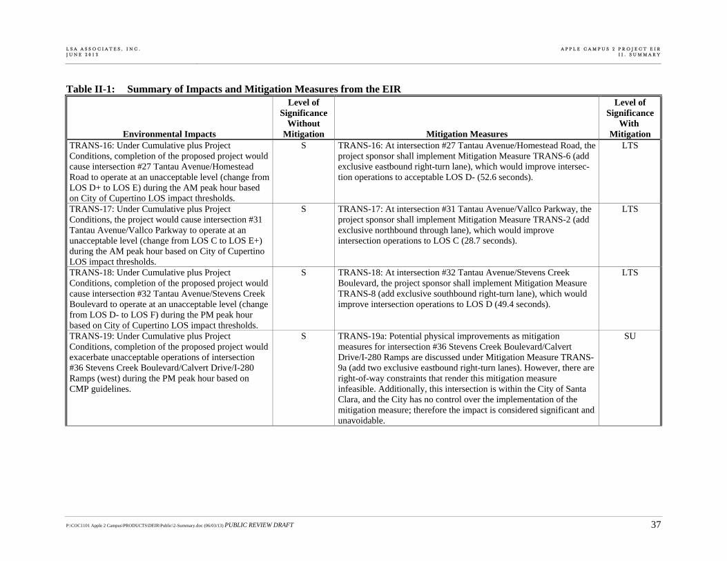
L S A A S S O C I A T E S , I N C . J U N E 2 0 1 3
A P P L E C A M P U S 2 P R O J E C T E I RI I . S U M M A R Y
P:\COC1101 Apple 2 Campus\PRODUCTS\DEIR\Public\2-Summary.doc (06/03/13) PUBLIC REVIEW DRAFT 37
Table II-1: Summary of Impacts and Mitigation Measures from the EIR
Environmental Impacts
Level of Significance
Without Mitigation Mitigation Measures
Level of Significance
With Mitigation
TRANS-16: Under Cumulative plus Project Conditions, completion of the proposed project would cause intersection #27 Tantau Avenue/Homestead Road to operate at an unacceptable level (change from LOS D+ to LOS E) during the AM peak hour based on City of Cupertino LOS impact thresholds.
S TRANS-16: At intersection #27 Tantau Avenue/Homestead Road, the project sponsor shall implement Mitigation Measure TRANS-6 (add exclusive eastbound right-turn lane), which would improve intersec-tion operations to acceptable LOS D- (52.6 seconds).
LTS
TRANS-17: Under Cumulative plus Project Conditions, the project would cause intersection #31 Tantau Avenue/Vallco Parkway to operate at an unacceptable level (change from LOS C to LOS E+) during the AM peak hour based on City of Cupertino LOS impact thresholds.
S TRANS-17: At intersection #31 Tantau Avenue/Vallco Parkway, the project sponsor shall implement Mitigation Measure TRANS-2 (add exclusive northbound through lane), which would improve intersection operations to LOS C (28.7 seconds).
LTS
TRANS-18: Under Cumulative plus Project Conditions, completion of the proposed project would cause intersection #32 Tantau Avenue/Stevens Creek Boulevard to operate at an unacceptable level (change from LOS D- to LOS F) during the PM peak hour based on City of Cupertino LOS impact thresholds.
S TRANS-18: At intersection #32 Tantau Avenue/Stevens Creek Boulevard, the project sponsor shall implement Mitigation Measure TRANS-8 (add exclusive southbound right-turn lane), which would improve intersection operations to LOS D (49.4 seconds).
LTS
TRANS-19: Under Cumulative plus Project Conditions, completion of the proposed project would exacerbate unacceptable operations of intersection #36 Stevens Creek Boulevard/Calvert Drive/I-280 Ramps (west) during the PM peak hour based on CMP guidelines.
S TRANS-19a: Potential physical improvements as mitigation measures for intersection #36 Stevens Creek Boulevard/Calvert Drive/I-280 Ramps are discussed under Mitigation Measure TRANS-9a (add two exclusive eastbound right-turn lanes). However, there are right-of-way constraints that render this mitigation measure infeasible. Additionally, this intersection is within the City of Santa Clara, and the City has no control over the implementation of the mitigation measure; therefore the impact is considered significant and unavoidable.
SU
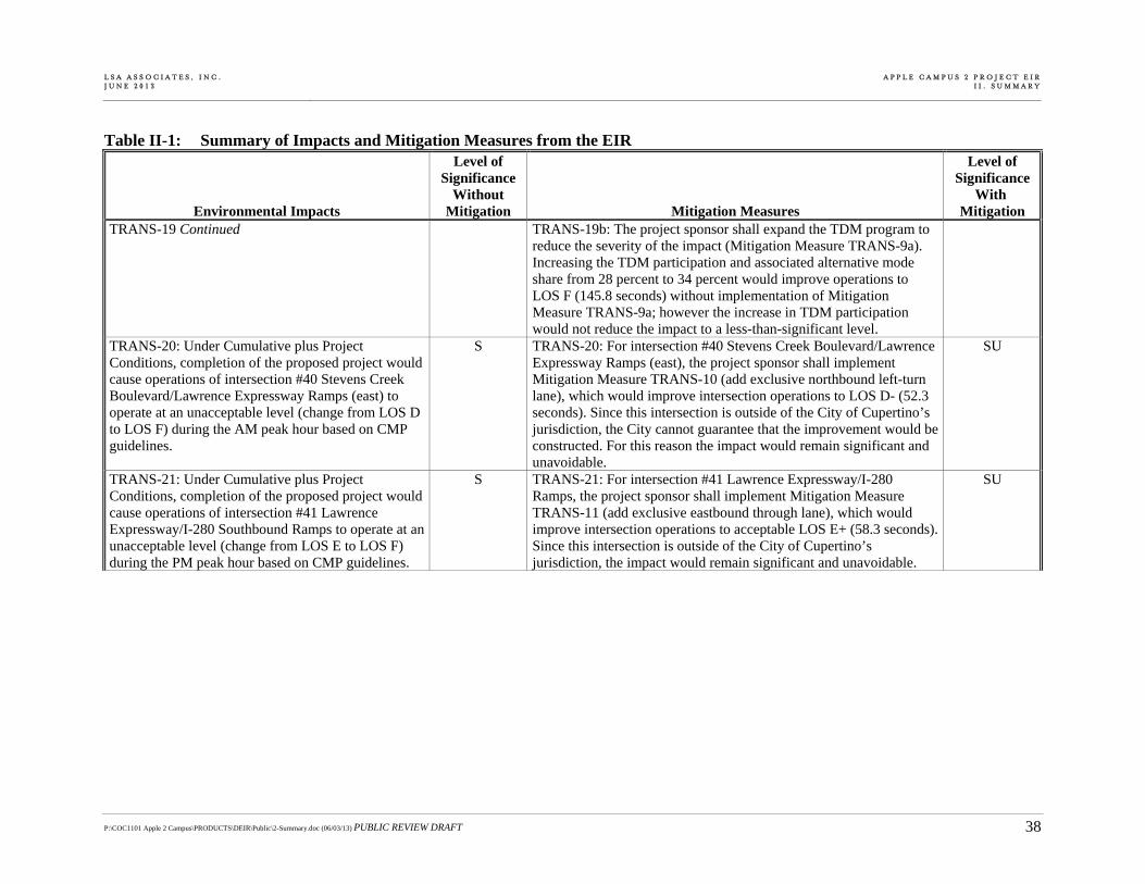
L S A A S S O C I A T E S , I N C . J U N E 2 0 1 3
A P P L E C A M P U S 2 P R O J E C T E I RI I . S U M M A R Y
P:\COC1101 Apple 2 Campus\PRODUCTS\DEIR\Public\2-Summary.doc (06/03/13) PUBLIC REVIEW DRAFT 38
Table II-1: Summary of Impacts and Mitigation Measures from the EIR
Environmental Impacts
Level of Significance
Without Mitigation Mitigation Measures
Level of Significance
With Mitigation
TRANS-19 Continued TRANS-19b: The project sponsor shall expand the TDM program to reduce the severity of the impact (Mitigation Measure TRANS-9a). Increasing the TDM participation and associated alternative mode share from 28 percent to 34 percent would improve operations to LOS F (145.8 seconds) without implementation of Mitigation Measure TRANS-9a; however the increase in TDM participation would not reduce the impact to a less-than-significant level.
TRANS-20: Under Cumulative plus Project Conditions, completion of the proposed project would cause operations of intersection #40 Stevens Creek Boulevard/Lawrence Expressway Ramps (east) to operate at an unacceptable level (change from LOS D to LOS F) during the AM peak hour based on CMP guidelines.
S TRANS-20: For intersection #40 Stevens Creek Boulevard/Lawrence Expressway Ramps (east), the project sponsor shall implement Mitigation Measure TRANS-10 (add exclusive northbound left-turn lane), which would improve intersection operations to LOS D- (52.3 seconds). Since this intersection is outside of the City of Cupertino’s jurisdiction, the City cannot guarantee that the improvement would be constructed. For this reason the impact would remain significant and unavoidable.
SU
TRANS-21: Under Cumulative plus Project Conditions, completion of the proposed project would cause operations of intersection #41 Lawrence Expressway/I-280 Southbound Ramps to operate at an unacceptable level (change from LOS E to LOS F) during the PM peak hour based on CMP guidelines.
S TRANS-21: For intersection #41 Lawrence Expressway/I-280 Ramps, the project sponsor shall implement Mitigation Measure TRANS-11 (add exclusive eastbound through lane), which would improve intersection operations to acceptable LOS E+ (58.3 seconds). Since this intersection is outside of the City of Cupertino’s jurisdiction, the impact would remain significant and unavoidable.
SU

L S A A S S O C I A T E S , I N C . J U N E 2 0 1 3
A P P L E C A M P U S 2 P R O J E C T E I RI I . S U M M A R Y
P:\COC1101 Apple 2 Campus\PRODUCTS\DEIR\Public\2-Summary.doc (06/03/13) PUBLIC REVIEW DRAFT 39
Table II-1: Summary of Impacts and Mitigation Measures from the EIR
Environmental Impacts
Level of Significance
Without Mitigation Mitigation Measures
Level of Significance
With Mitigation
TRANS-22: Completion of the proposed project would add substantial amounts of traffic to the following ten mixed flow segments and one HOV freeway segment operating at LOS F:
I-280, Northbound, SR 85 to Foothill Expressway
I-280, Southbound, Foothill Expressway to SR 85
I-280, Southbound, SR 85 to De Anza Boulevard
I-280, Southbound, De Anza Boulevard to Wolfe Road
I-280, Northbound, Lawrence Expressway/Stevens Creek Boulevard to Wolfe Road
I-280, Southbound, Wolfe Road to Lawrence Expressway/Stevens Creek Boulevard
I-280, Northbound, Saratoga Avenue to Lawrence Expressway/Stevens Creek Boulevard
I-280, Southbound, Lawrence Expressway/Stevens Creek Boulevard to Saratoga Avenue
I-280, Northbound, Winchester Boulevard to Saratoga Avenue
SR 85, Northbound, Winchester Boulevard to Saratoga Avenue
I-280, HOV Northbound, Lawrence Expressway/Stevens Creek Boulevard to Saratoga Avenue
These freeway segments would be impacted under the Existing Plus Project Conditions based on CMP guidelines.
S TRANS-22: The project sponsor shall pay a $536,000 fair share contribution towards two planned transportation projects identified in VTA’s Valley Transportation Plan 2035 (VTP 2035) that would improve traffic operations of the impacted freeway segments and provide added transportation capacity on parallel facilities: (1) SR 85 Express Lane project (converting the existing HOV lane to a toll lane to allow single occupant vehicles to drive in the HOV lane for a fee) between Mountain View and San Jose and (2) the Bus Rapid Transit (BRT) station on Stevens Creek Boulevard at Wolfe Road and De Anza Boulevard. The fair share contribution amount was calculated in consultation with VTA staff based on the project’s contribution to project growth on the impacted freeway segment. It is unlikely that the Express Lane or BRT project would be imple-mented prior to project completion and that these improvements would reduce the impact to a less-than-significant level. In addition, the City has no control over the implementation of these mitigation measures; therefore the impact to the freeway segments would remain significant and unavoidable.
SU
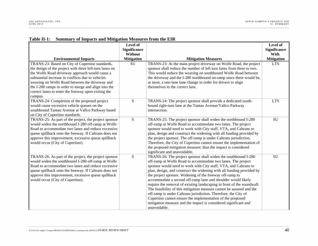
L S A A S S O C I A T E S , I N C . J U N E 2 0 1 3
A P P L E C A M P U S 2 P R O J E C T E I RI I . S U M M A R Y
P:\COC1101 Apple 2 Campus\PRODUCTS\DEIR\Public\2-Summary.doc (06/03/13) PUBLIC REVIEW DRAFT 40
Table II-1: Summary of Impacts and Mitigation Measures from the EIR
Environmental Impacts
Level of Significance
Without Mitigation Mitigation Measures
Level of Significance
With Mitigation
TRANS-23: Based on City of Cupertino standards, the design of the project with three left-turn lanes on the Wolfe Road driveway approach would cause a substantial increase in conflicts due to vehicles weaving on Wolfe Road between the driveway and the I-280 ramps in order to merge and align into the correct lanes to enter the freeway upon exiting the campus.
SU TRANS-23: At the main project driveway on Wolfe Road, the project sponsor shall reduce the number of left turn lanes from three to two. This would reduce the weaving on southbound Wolfe Road between the driveway and the I-280 northbound on-ramp since there would be, at most, a one-lane lane change in order for drivers to align themselves to the correct lane.
LTS
TRANS-24: Completion of the proposed project would cause excessive vehicle queues on the southbound Tantau Avenue at Vallco Parkway based on City of Cupertino standards.
S TRANS-24: The project sponsor shall provide a dedicated south-bound right-turn lane at the Tantau Avenue/Vallco Parkway intersection.
LTS
TRANS-25: As part of the project, the project sponsor would widen the northbound I-280 off-ramp at Wolfe Road to accommodate two lanes and reduce excessive queue spillback onto the freeway. If Caltrans does not approve this improvement, excessive queue spillback would occur (City of Cupertino).
S TRANS-25: The project sponsor shall widen the northbound I-280 off-ramp at Wolfe Road to accommodate two lanes. The project sponsor would need to work with City staff, VTA, and Caltrans to plan, design and construct the widening with all funding provided by the project sponsor. The off-ramp is under Caltrans jurisdiction. Therefore, the City of Cupertino cannot ensure the implementation of the proposed mitigation measure; thus the impact is considered significant and unavoidable.
SU
TRANS-26: As part of the project, the project sponsor would widen the southbound I-280 off-ramp at Wolfe Road to accommodate two lanes and reduce excessive queue spillback onto the freeway. If Caltrans does not approve this improvement, excessive queue spillback would occur (City of Cupertino).
S TRANS-26: The project sponsor shall widen the southbound I-280 off-ramp at Wolfe Road to accommodate two lanes. The project sponsor would need to work with City staff, VTA, and Caltrans to plan, design, and construct the widening with all funding provided by the project sponsor. Widening of the freeway off-ramp to accommodate a second off-ramp lane and shoulder would likely require the removal of existing landscaping in front of the soundwall. The feasibility of this mitigation measure cannot be assured and the off-ramp is under Caltrans jurisdiction. Therefore, the City of Cupertino cannot ensure the implementation of the proposed mitigation measure and the impact is considered significant and unavoidable.
SU

L S A A S S O C I A T E S , I N C . J U N E 2 0 1 3
A P P L E C A M P U S 2 P R O J E C T E I RI I . S U M M A R Y
P:\COC1101 Apple 2 Campus\PRODUCTS\DEIR\Public\2-Summary.doc (06/03/13) PUBLIC REVIEW DRAFT 41
Table II-1: Summary of Impacts and Mitigation Measures from the EIR
Environmental Impacts
Level of Significance
Without Mitigation Mitigation Measures
Level of Significance
With Mitigation
TRANS-27: The proposed location of the project driveway intersection on Wolfe Road and the associated congestion would result in hazards for vehicles exiting the southernmost Wolfe Road driveway to the Cupertino Village shopping center (City of Cupertino and CEQA).
S TRANS-27: The southernmost driveway to the Cupertino Village should be closed or restricted to right-turns in only. With this mitigation the impact would be less-than-significant.
LTS
TRANS-28: The provision of two northbound inbound right-turn lanes and six lanes on the east leg of the Wolfe Road/Project Access intersection with the associated high traffic volumes would interfere with pedestrian accessibility to the site and adjoining areas (City of Cupertino).
S TRANS-28: To lessen the impact the project sponsor shall install a “Yield to Peds” sign that is activated by a pedestrian push button. Additionally, the project shall install a high visibility crosswalk (i.e., with ladder striping) at the east leg of the Wolfe Road/Project Access intersection to help make the crosswalk more prominent. These treatments would lessen the impact, but would not mitigate the impact to a less-than-significant level as pedestrian access would still be impeded.
SU
TRANS-29: The increased traffic volume at the I-280 ramps with Wolfe Road would create a challenging condition for pedestrians that currently does not exist (City of Cupertino).
S TRANS-29: To enhance the pedestrian environment and lessen the pedestrian impact at the six I-280 ramps with Wolfe Road, the project sponsor shall provide enhanced crosswalks at all ramp crosswalks. Additionally, for the I-280 southbound loop on-ramp, the project sponsor shall design, construct, and fund the following to improve the sight distance to an industry standard of 250 feet for a 35 mph roadway include:
Replacing existing fence on overcrossing with one that has better transparency;
Trimming and maintaining vegetation on northwest corner of the Wolfe Road/I-280 southbound loop on-ramp;
Redesigning the ramp to move the crosswalk further north; and
Adding a pavement legend to indicate pedestrian crossing.
SU

L S A A S S O C I A T E S , I N C . J U N E 2 0 1 3
A P P L E C A M P U S 2 P R O J E C T E I RI I . S U M M A R Y
P:\COC1101 Apple 2 Campus\PRODUCTS\DEIR\Public\2-Summary.doc (06/03/13) PUBLIC REVIEW DRAFT 42
Table II-1: Summary of Impacts and Mitigation Measures from the EIR
Environmental Impacts
Level of Significance
Without Mitigation Mitigation Measures
Level of Significance
With Mitigation
TRANS-29 Continued The treatments would lessen the impact, but would not mitigate the impact to a less-than-significant level, as the increased vehicular volumes would still exist. Further, the feasibility of this mitigation measure cannot be assured as the on-ramp is under Caltrans jurisdiction. Therefore, the City of Cupertino cannot ensure the implementation of the mitigation measure.
TRANS-30: The added traffic on Wolfe Road and around the project site would result in increased congestion and could induce transit demand and increase transit ridership in the area, which currently has minimal transit stop amenities (VTA).
S TRANS-30: The project sponsor shall upgrade transit stops along Wolfe Road between Stevens Creek Boulevard and Homestead Road, on Vallco Parkway between Wolfe Road and Tantau Avenue, on Tantau Avenue between Stevens Creek Boulevard and Homestead Road, and on Homestead Road between Tantau Avenue and Wolfe Road.
LTS
TRANS-31: The proposed closure of Pruneridge Avenue between Wolfe Road and Tantau Avenue would have significant impacts on pedestrian access because it would reduce accessibility for pedestrians and eliminate existing pedestrian facilities (City of Cupertino).
S TRANS-31: Implement Mitigation Measures PLAN-2 and PLAN-3. The multi-use paths and the pedestrian improvements proposed as part of the project would lessen the impact, but would not mitigate the impact to a less-than-significant level as the elimination of existing pedestrian facilities would still occur.
SU
TRANS-32: The proposed closure of Pruneridge Avenue between Wolfe Road and Tantau Avenue would have significant impacts on bicycle access because it would reduce accessibility for bicyclists and eliminates existing bicycle facilities (City of Cupertino).
S TRANS-32: Implement Mitigation Measure PLAN-2 and PLAN-3. The multi-use paths and bicycle improvements proposed as part of the project would lessen the impact, but would not mitigate the impact to a less-than-significant level as the elimination of existing bicycle facilities would still occur.
SU
TRANS-33: The proposed closure of Pruneridge Avenue and associated reroute of Route 81 to Vallco Parkway would significantly reduce transit access for The Hamptons residents (City of Cupertino).
S TRANS-33: There are no feasible mitigation measures to restore transit access to Route 81 for The Hamptons residents, therefore the impact is considered significant and unavoidable.
SU

L S A A S S O C I A T E S , I N C . J U N E 2 0 1 3
A P P L E C A M P U S 2 P R O J E C T E I RI I . S U M M A R Y
P:\COC1101 Apple 2 Campus\PRODUCTS\DEIR\Public\2-Summary.doc (06/03/13) PUBLIC REVIEW DRAFT 43
Table II-1: Summary of Impacts and Mitigation Measures from the EIR
Environmental Impacts
Level of Significance
Without Mitigation Mitigation Measures
Level of Significance
With Mitigation
TRANS-34: The proposed closure of Pruneridge Avenue between Wolfe Road and Tantau Avenue would have significant impacts on access to The Hamptons for those with destinations east of Tantau Avenue (City of Cupertino).
S TRANS-34: There are no mitigation measures to reduce the impact to a less-than-significant level. Implementation of Mitigation Measure TRANS-32 would lessen the impact, but not to a less-than-significant level.
SU
TRANS-35: The project may result in a parking shortfall if Apple does not achieve a 34 percent TDM participation rate.
S TRANS-35: Implement Mitigation Measure TRANS-9b. LTS
J. NOISE NOI-1: Project-related construction activities would create a clearly noticeable temporary change in the noise environment and create noise levels that would exceed the noise level standards in the City of Cupertino Municipal Code.
S NOI-1: The project applicant shall implement the following measures at the project site during all demolition and construction activities, subject to the approval of the City:
The project applicant shall ensure the construction of a 15-foot high temporary sound wall along the project’s property line adjacent to sensitive land uses.
o A temporary sound wall shall be constructed along the eastern project property line to block the line-of-sight from the single-family residential land uses on Howard Drive and Meadow Avenue to project construction areas on the east side of North Tantau Avenue. This sound wall shall be set back from the property line as much as feasible to still allow for project construction activities to occur.
o A temporary sound wall shall be constructed along the southern project property line to block the line-of-sight from The Hamptons to project construction areas in the southwest portion of the project site. This sound wall shall be set back from the property line as much as feasible to still allow for project construction activities to occur.
LTS

L S A A S S O C I A T E S , I N C . J U N E 2 0 1 3
A P P L E C A M P U S 2 P R O J E C T E I RI I . S U M M A R Y
P:\COC1101 Apple 2 Campus\PRODUCTS\DEIR\Public\2-Summary.doc (06/03/13) PUBLIC REVIEW DRAFT 44
Table II-1: Summary of Impacts and Mitigation Measures from the EIR
Environmental Impacts
Level of Significance
Without Mitigation Mitigation Measures
Level of Significance
With Mitigation
NOI-1 Continued o A temporary sound wall shall be constructed along the northern project property line to block the line-of-sight from the single-family residential properties north of East Homestead Road to project construction areas in the northern portion of the project site. This sound wall shall be set back from the property line as much as feasible to still allow for project construction activities to occur.
The project contractor shall designate a construction liaison that shall be responsible for responding to any local com-plaints about construction noise. The liaison shall determine the cause of the noise complaints (e.g., starting too early, bad muffler) and institute reasonable measures to correct the problem. A telephone number for the liaison shall be conspic-uously posted at the perimeter of the construction site and provided to all adjacent property owners prior to commence-ment of construction.
The project contractor shall ensure that all construction equipment has appropriate high-quality noise muffling and abatement devices, which would be properly maintained and used at all times such equipment is in operation.
The project contractor shall, to the extent feasible, place all stationary construction equipment so that emitted noise is directed away from sensitive receptors nearest the project site.
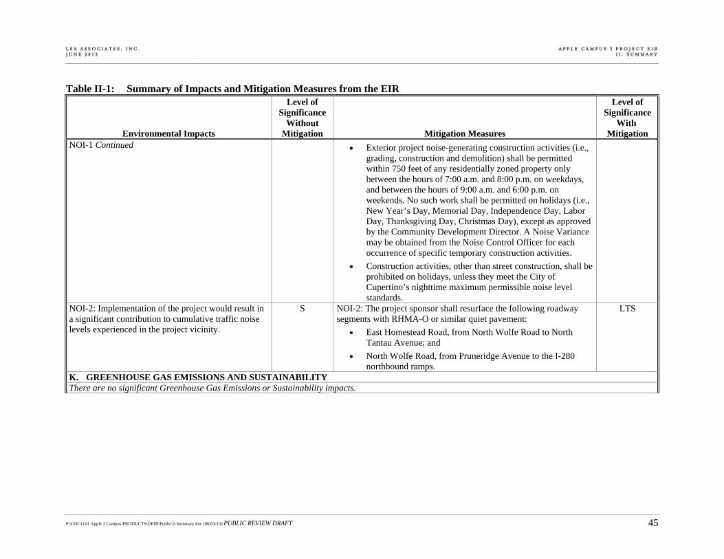
L S A A S S O C I A T E S , I N C . J U N E 2 0 1 3
A P P L E C A M P U S 2 P R O J E C T E I RI I . S U M M A R Y
P:\COC1101 Apple 2 Campus\PRODUCTS\DEIR\Public\2-Summary.doc (06/03/13) PUBLIC REVIEW DRAFT 45
Table II-1: Summary of Impacts and Mitigation Measures from the EIR
Environmental Impacts
Level of Significance
Without Mitigation Mitigation Measures
Level of Significance
With Mitigation
NOI-1 Continued Exterior project noise-generating construction activities (i.e., grading, construction and demolition) shall be permitted within 750 feet of any residentially zoned property only between the hours of 7:00 a.m. and 8:00 p.m. on weekdays, and between the hours of 9:00 a.m. and 6:00 p.m. on weekends. No such work shall be permitted on holidays (i.e., New Year’s Day, Memorial Day, Independence Day, Labor Day, Thanksgiving Day, Christmas Day), except as approved by the Community Development Director. A Noise Variance may be obtained from the Noise Control Officer for each occurrence of specific temporary construction activities.
Construction activities, other than street construction, shall be prohibited on holidays, unless they meet the City of Cupertino’s nighttime maximum permissible noise level standards.
NOI-2: Implementation of the project would result in a significant contribution to cumulative traffic noise levels experienced in the project vicinity.
S NOI-2: The project sponsor shall resurface the following roadway segments with RHMA-O or similar quiet pavement:
East Homestead Road, from North Wolfe Road to North Tantau Avenue; and
North Wolfe Road, from Pruneridge Avenue to the I-280 northbound ramps.
LTS
K. GREENHOUSE GAS EMISSIONS AND SUSTAINABILITYThere are no significant Greenhouse Gas Emissions or Sustainability impacts.

L S A A S S O C I A T E S , I N C . J U N E 2 0 1 3
A P P L E C A M P U S 2 P R O J E C T E I RI I . S U M M A R Y
P:\COC1101 Apple 2 Campus\PRODUCTS\DEIR\Public\2-Summary.doc (06/03/13) PUBLIC REVIEW DRAFT 46
Table II-1: Summary of Impacts and Mitigation Measures from the EIR
Environmental Impacts
Level of Significance
Without Mitigation Mitigation Measures
Level of Significance
With Mitigation
L. AIR QUALITY AIR-1: Construction of the proposed project would generate air pollutant emissions that could violate air quality standards.
S AIR-1: Consistent with guidance from the BAAQMD, the following actions shall be required in relevant construction contracts and specifications for the project:
All exposed surfaces (e.g., parking areas, staging areas, soil piles, graded areas, and unpaved access roads) shall be watered two times per day.
All haul trucks transporting soil, sand, or other loose material off-site shall be covered.
All visible mud or dirt tracked-out onto adjacent public roads shall be removed using wet power vacuum street sweepers at least once per day. The use of dry power sweeping is prohibited.
All vehicle speeds on unpaved roads shall be limited to 15 miles per hour (mph).
All roadways, driveways, and sidewalks to be paved shall be completed as soon as possible. Building pads shall be laid as soon as possible after grading unless seeding or soil binders are used.
Construction equipment idling times shall be minimized either by shutting equipment off when not in use or reducing the maximum idling time to 2 minutes (as required by the California airborne toxics control measure Title 13, Section 2485 of California Code of Regulations [CCR]). Clear signage shall be provided for construction workers at all access points.
All construction equipment shall be maintained and properly tuned in accordance with the manufacturer’s specifications. All equipment shall be checked by a certified mechanic and determined to be running in proper condition prior to operation.
SU
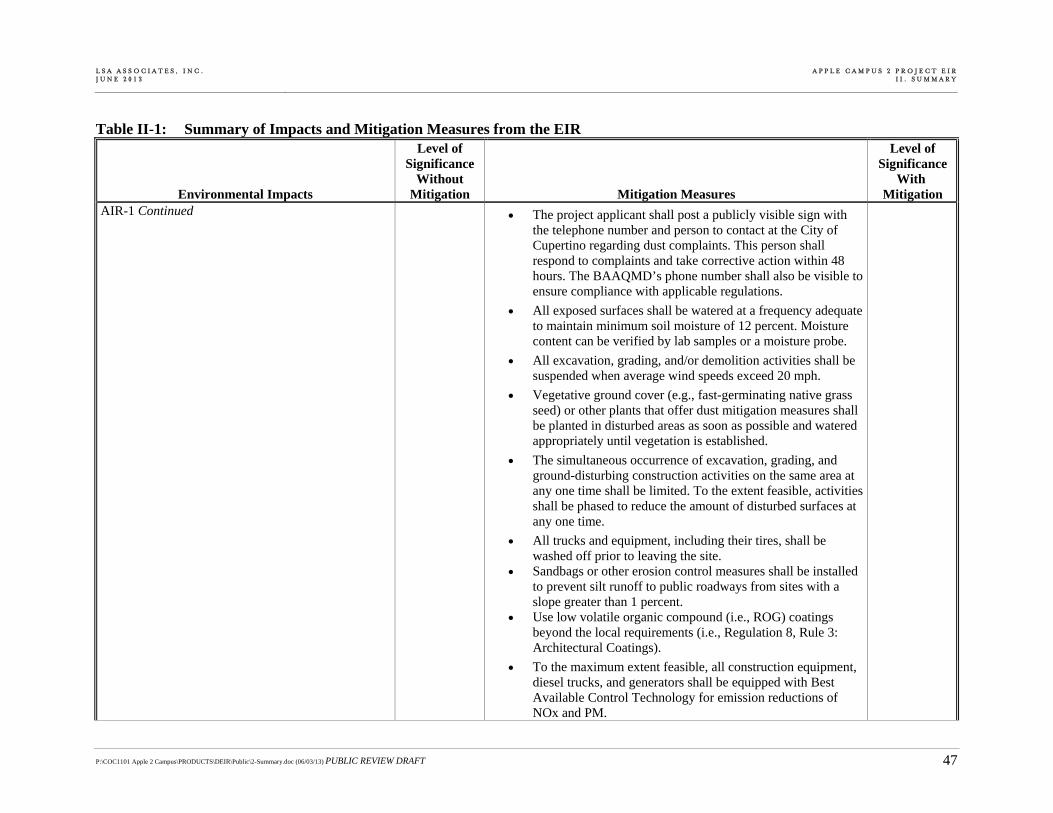
L S A A S S O C I A T E S , I N C . J U N E 2 0 1 3
A P P L E C A M P U S 2 P R O J E C T E I RI I . S U M M A R Y
P:\COC1101 Apple 2 Campus\PRODUCTS\DEIR\Public\2-Summary.doc (06/03/13) PUBLIC REVIEW DRAFT 47
Table II-1: Summary of Impacts and Mitigation Measures from the EIR
Environmental Impacts
Level of Significance
Without Mitigation Mitigation Measures
Level of Significance
With Mitigation
AIR-1 Continued The project applicant shall post a publicly visible sign with the telephone number and person to contact at the City of Cupertino regarding dust complaints. This person shall respond to complaints and take corrective action within 48 hours. The BAAQMD’s phone number shall also be visible to ensure compliance with applicable regulations.
All exposed surfaces shall be watered at a frequency adequate to maintain minimum soil moisture of 12 percent. Moisture content can be verified by lab samples or a moisture probe.
All excavation, grading, and/or demolition activities shall be suspended when average wind speeds exceed 20 mph.
Vegetative ground cover (e.g., fast-germinating native grass seed) or other plants that offer dust mitigation measures shall be planted in disturbed areas as soon as possible and watered appropriately until vegetation is established.
The simultaneous occurrence of excavation, grading, and ground-disturbing construction activities on the same area at any one time shall be limited. To the extent feasible, activities shall be phased to reduce the amount of disturbed surfaces at any one time.
All trucks and equipment, including their tires, shall be washed off prior to leaving the site.
Sandbags or other erosion control measures shall be installed to prevent silt runoff to public roadways from sites with a slope greater than 1 percent.
Use low volatile organic compound (i.e., ROG) coatings beyond the local requirements (i.e., Regulation 8, Rule 3: Architectural Coatings).
To the maximum extent feasible, all construction equipment, diesel trucks, and generators shall be equipped with Best Available Control Technology for emission reductions of NOx and PM.

L S A A S S O C I A T E S , I N C . J U N E 2 0 1 3
A P P L E C A M P U S 2 P R O J E C T E I RI I . S U M M A R Y
P:\COC1101 Apple 2 Campus\PRODUCTS\DEIR\Public\2-Summary.doc (06/03/13) PUBLIC REVIEW DRAFT 48
Table II-1: Summary of Impacts and Mitigation Measures from the EIR
Environmental Impacts
Level of Significance
Without Mitigation Mitigation Measures
Level of Significance
With Mitigation
AIR-1 Continued To the maximum extent feasible, all contractors shall use equipment that meets ARB’s most recent certification standard for off-road heavy duty diesel engines.
Excluding the following equipment, ensure that all diesel-powered off-road equipment used on-site meets U.S. EPA “Tier 2” exhaust emission standards, and that engines are equipped with California ARB “Level 3 Verified Diesel Emission Control Strategies” (which include diesel particu-late filters) or are certified to meet the U.S. EPA “Tier 4 Interim” standard for particulate matter emissions. Equipment that will meet U.S. EPA “Tier 2” exhaust emission standards but will not be equipped with California “Level 3 Verified Diesel Emission Control Strategy” shall be limited to:
o Scrapers 623G
o Scrapers 633B
o Four of the six proposed Scrapers 657G
Ensure that trucks used at the site to haul material and/or soil are model year 2007 or newer (or meet equivalent U.S. EPA emission standards).
Require all aerial and personnel lifts less than 50 horsepower to be fueled with natural gas or propane.
AIR-2: Operation of the proposed project would generate air pollutant emissions that would exceed the BAAQMD criteria and could substantially contribute to a violation of air quality standards.
S AIR-2: Implement Mitigation Measure TRANS-9b (which requires Apple to expand its TDM Program and increase the reduction in peak hour trips from 28 percent to 34 percent).
SU
AIR-3: Construction and operation of the proposed project would result in a significant cumulative net increase in criteria pollutant emissions.
S AIR-3: Implement Mitigation Measures AIR-1 and AIR-2. SU

L S A A S S O C I A T E S , I N C . J U N E 2 0 1 3
A P P L E C A M P U S 2 P R O J E C T E I RI I . S U M M A R Y
P:\COC1101 Apple 2 Campus\PRODUCTS\DEIR\Public\2-Summary.doc (06/03/13) PUBLIC REVIEW DRAFT 49
Table II-1: Summary of Impacts and Mitigation Measures from the EIR
Environmental Impacts
Level of Significance
Without Mitigation Mitigation Measures
Level of Significance
With Mitigation
AIR-4: Without the construction practices identified in the Apple Campus Construction Equipment Summary, construction of the proposed project would expose sensitive receptors to substantial pollutant concentrations.
S AIR-4: The project sponsor shall implement Mitigation Measure AIR-1 and the following additional measure:
To the maximum extent feasible, material staging roads shall be set back from the curb by at least 65 feet.
LTS
M. PUBLIC SERVICES AND UTILITIES PSU-1: The proposed project could adversely affect the ability of the SCCFD to meet response time objectives.
S PSU-1: The project sponsor shall implement signal preemption signals at the following intersections (identified by the City and SCCFD as the ones most likely to be used by emergency vehicles accessing the project site). The signal preemption signals would allow emergency vehicles to pass through approximately 30 seconds before arrival.
North Blaney Avenue and East Homestead Road North Tantau Avenue and East Homestead Road North Tantau Avenue and Pruneridge Avenue North Tantau Avenue and Vallco Parkway North Tantau Avenue and Project Entrance North Wolfe Road and Pruneridge Avenue North Wolfe Road and Project Entrance North Wolfe Road and East Homestead Road North Wolfe Road and I-280 (two interchanges) North Wolfe Road and Vallco Parkway Stevens Creek Boulevard and Perimeter Road Stevens Creek Boulevard and Finch Avenue Stevens Creek Boulevard and Tantau Avenue Heron Avenue and East Homestead Road
LTS
PSU-2: The proposed project would contribute to a shortage of park facilities for City residents and would preclude the development of an open space trail through the project site.
S PSU-2: Implement Mitigation Measures PLAN-1 and PLAN-3. SU
Source: LSA Associates, Inc., 2013.

L S A A S S O C I A T E S , I N C . J U N E 2 0 1 3
A P P L E C A M P U S 2 P R O J E C T E I RI I . S U M M A R Y
P:\COC1101 Apple 2 Campus\PRODUCTS\DEIR\Public\2-Summary.doc (06/03/13) PUBLIC REVIEW DRAFT 50
This page intentionally left blank.