A Plan for the City of York (1948) Bill...
20
1 A Plan for the City of York (1948) Bill Fawcett Originally printed in York Historian 30: 2013 Summary: In 1943 York Corporation commissioned work on a plan for the physical development of the city, which bore fruit in several policies adopted by the Council prior to the 1947 Town & Country Planning Act. However, the public presentation of the scheme was deferred until 1948, when the Central Area proposals were featured in an exhibition and report whose main features are examined in this article. The plan sought to conserve the walled city at the expense of the area immediately surrounding it, which would have been redeveloped to provide a ‘green belt’ accompanied by an inner ring road which became an increasingly controversial feature of city policy until its abandonment in 1975. The illustrations have been taken from the 1948 plan, with minimal editing. Figures 2 and 3 have been rendered from colour into greyscale. Figures 5, 6, and 7 are details from them. Introduction Amidst the rigours of World War 2, optimistic spirits turned their attention to planning for a more equitable Britain afterwards. Best known is the work of Sir William Beveridge who was invited by the government to produce the report: Social Insurance and Allied Services, which came out in 1942 and provided a blueprint for the post-war Welfare State. However, the extension of interim development control to the country as a whole in 1943, while intended to facilitate the replacement of areas of extensive bomb damage, also flagged a more general desire for urban renewal. Local authorities set work in hand to produce plans for post-war development and many were published in advance of the 1947 Town & Country Planning Act. Thus Sir Patrick Abercrombie’s plans for Bath and Hull came out in 1945 and J.N. Meredith’s “megalomaniac” scheme for Bristol in 1946. The plan for York was commissioned in 1943 and key elements had been adopted by 1945 although formal publication of the city-centre proposals, as York: a Plan for Progress and Preservation, was delayed until 1948. The York Background Development under public auspices for the public good was not a twentieth-century innovation in York. The previous century had already produced works such as St. Leonard’s Place, Parliament Street, Lendal Bridge, Skeldergate Bridge and Clifford Street but the power to direct or regulate private building was limited to the health and drainage provisions under the 1848 Health of Towns Act 1 and its 1875 successor, which introduced model bye-laws for new housing. The 1909 Housing & Town Planning Act was the first to formally embrace concepts such as land- use zoning and planning schemes; these were taken further by legislation in 1925 but it took the 1932 Act to make development control begin to seem a practical option. Local authorities were enabled to prepare planning schemes which would bring a specific area under development
Transcript of A Plan for the City of York (1948) Bill...

1
A Plan for the City of York (1948)
Bill Fawcett
Originally printed in York Historian 30: 2013
Summary: In 1943 York Corporation commissioned work on a plan for the physical development of
the city, which bore fruit in several policies adopted by the Council prior to the 1947 Town &
Country Planning Act. However, the public presentation of the scheme was deferred until 1948,
when the Central Area proposals were featured in an exhibition and report whose main features
are examined in this article. The plan sought to conserve the walled city at the expense of the area
immediately surrounding it, which would have been redeveloped to provide a ‘green belt’
accompanied by an inner ring road which became an increasingly controversial feature of city
policy until its abandonment in 1975.
The illustrations have been taken from the 1948 plan, with minimal editing. Figures 2 and 3 have
been rendered from colour into greyscale. Figures 5, 6, and 7 are details from them.
Introduction
Amidst the rigours of World War 2, optimistic spirits turned their attention to planning for a more
equitable Britain afterwards. Best known is the work of Sir William Beveridge who was invited by
the government to produce the report: Social Insurance and Allied Services, which came out in 1942
and provided a blueprint for the post-war Welfare State. However, the extension of interim
development control to the country as a whole in 1943, while intended to facilitate the replacement
of areas of extensive bomb damage, also flagged a more general desire for urban renewal. Local
authorities set work in hand to produce plans for post-war development and many were
published in advance of the 1947 Town & Country Planning Act. Thus Sir Patrick Abercrombie’s
plans for Bath and Hull came out in 1945 and J.N. Meredith’s “megalomaniac” scheme for Bristol
in 1946. The plan for York was commissioned in 1943 and key elements had been adopted by 1945
although formal publication of the city-centre proposals, as York: a Plan for Progress and
Preservation, was delayed until 1948.
The York Background
Development under public auspices for the public good was not a twentieth-century innovation in
York. The previous century had already produced works such as St. Leonard’s Place, Parliament
Street, Lendal Bridge, Skeldergate Bridge and Clifford Street but the power to direct or regulate
private building was limited to the health and drainage provisions under the 1848 Health of
Towns Act1 and its 1875 successor, which introduced model bye-laws for new housing.
The 1909 Housing & Town Planning Act was the first to formally embrace concepts such as land-
use zoning and planning schemes; these were taken further by legislation in 1925 but it took the
1932 Act to make development control begin to seem a practical option. Local authorities were
enabled to prepare planning schemes which would bring a specific area under development

2
control if the proposal passed the hurdle of Ministerial consent. This was not meant to stifle
development in any way; indeed a major aim was to encourage the orderly private development of
suburban land for housing to complement the municipal housing programmes put in place after
the First World War.
York Corporation was active in slum clearance and house building during the interwar years,
examples being the clearance of Hungate and development of Tang Hall estate. It also began
building an outer ring road to cope with the growth in road motor traffic, something which had
barely existed prior to the First World War, and a substantial vestige of this, later-abandoned,
scheme is still to be seen at Kingsway North.
The Council took up the 1932 Act powers in order to protect the character of the city’s historic core.
The City of York (Special Area) Planning Scheme was approved by the Minister of Health (then
responsible for town planning) in March 1937, becoming operative on 28 July2, and covered the
walled city and four main approaches: Clifton, Heworth, Hull Road and Dringhouses. The Act
provided for preservation orders to be placed on buildings of architectural and historic interest but
these were subject to ministerial confirmation and only to be used sparingly. In practice, the main
thrust of the Central Area scheme was the control of street elevations, in which the Council was
guided by its Advisory Panel of Architects, in some ways a forerunner of today’s Conservation
Areas Advisory Panel. This was a remarkable step towards the concept of area-based conservation
which would underlie the Civic Amenities Act introduced thirty years later (1967). Thus York had
already demonstrated a progressive engagement with planning before the War.
Making the Plan for York
In 1943 a Ministry of Town and Country Planning was established and interim development
control was extended to all parts of England and Wales not already covered by schemes such as
the 1937 Central York one. This gave local authorities powers to plan for the post-war world, and
in the same year York commissioned a development plan from Professor Adshead and Major
Needham, assisted by City Engineer C.J. Minter.
Stanley Davenport Adshead (1868-1946) was a pioneering figure in town planning.3 Trained as an
architect, he practised on a relatively modest scale after being appointed in 1909 to the newly-
established post as Reader, and subsequently Professor, of Civic Design at Liverpool University. In
1914 he became Professor of Town Planning at the University of London, holding this post until
his retirement in 1935. He remained active, however, producing a planning report for Scarborough
in 1938 and publishing in 1941 the book A New England, ‘a contribution to the discussion of post-
war planning, with many original and idiosyncratic ideas.’4
Adshead was initially attracted to the American Beaux Arts concepts of the early nineteen-
hundreds, as exemplified in the work of designers like McKim, Mead & White. However, his best-
known buildings are those designed, in partnership with Stanley Ramsey, for the Duchy of
Cornwall’s Kennington Estate in South London (1911 onwards). These display Adshead’s

3
sympathy for late-Georgian and Regency architecture, and will have found favour in York, where
the surge of interest in and concern to conserve this aspect of the city’s heritage had led to the
formation of the York Georgian Society in 1939. Adshead died in April 1946, two years before the
Plan for York was published, but the proposals were by then virtually complete.5
His colleagues, Needham and Minter, carried on without further outside assistance, and the plan
was published in 1948.6 Charles William Cashmore Needham (1893-1962) was a local architect,
son of Samuel Needham who had settled in York in the late nineteenth century and served as
architect to the Tadcaster Brewery Company (one example being his Fox Inn in Dringhouses)
before setting up independently in 1904. Charles trained with his father but became Housing
Architect for Leicester Corporation before returning to York in 1927 to carry on the family practice,
later known successively as Needham & Thorp and Needham, Thorp & White.
Charles Needham was keenly involved in local-authority housing and in town planning,
qualifying for the (Royal) Town Planning Institute in 1925 and acting as consultant to Councils as
varied as Hartlepool, Redcar, Richmond and Northallerton.7 His own tastes are represented by the
firm’s Sir John Hunt Memorial cottage homes in Fulford (1954): neat, carefully-designed
almshouses enlivened by shaped gables. He was sensitive to traditional styles and materials, and
was consulting architect to York’s Merchant Adventurers and Merchant Taylors as well as being a
founding member of York Georgian Society.
Charles Minter (1897-1991) had an eventful and unorthodox career, including a spell in the engine
sheds of the South Eastern & Chatham Railway, before entering local government.8 He became
deputy to York’s City Engineer and Surveyor in 1933, succeeding as City Engineer in August 1935.
This post had developed from the traditional office of City Surveyor to embrace the expanded
responsibilities of the twentieth-century Corporation, so that Minter had charge of the architectural
design carried out by the Council, notably the new municipal housing, prior to the appointment of
a City Architect. With the passing of the landmark Town & Country Planning Act in 1947, he went
on to become the City’s first Planning Officer as well, while both he and Needham were founder
members of York Civic Trust in 1946. Minter retired in 1962 but continued to take an active interest
in the city’s conservation and development.
So much for the people who drafted the Plan, now for its godfather: John Bowes Morrell.
J.B. Morrell and his influence
J.B. Morrell, who died in 1963, was a seminal figure in York civic life, occupying a position of
considerable influence in the worlds of business and local politics and combining a love of the city
with a passion for conserving its past, improving its present and building for its future. He set out
his vision in The City of Our Dreams, based on a 1935 lecture but published in 1940 to encourage
debate about what should happen after the War; a second edition, of 1955, followed the same basic
precepts. Morrell’s influence on the 1948 Plan is evident, but it went further than him in several
respects and in turn influenced the revisions seen in the second edition of his book.
4
Morrell’s practical grasp of what could and should be done is seen in the city’s acquisition of the
Castle and the adaptation of the Georgian buildings to house the Kirk collection, whilst
demolishing the later felons’ prison to create a site for municipal offices. He strongly backed the
outer ring road, which the Council began building in 1937, envisaging landmark exits from it into
the city at the junctions of the Thirsk, Scarborough, Fulford and Tadcaster roads. These would
have statues, such as the Roman soldier designated for the Thirsk road, along with well-designed
filling stations and hotels, such as the Imperial Hotel, built in 1937, which was picked out for special
mention. This tasteful essay, in a mildly-modernised neo-Tudor, was situated on the embryo ring-
road at Kingsway North until its demolition in 1994.
When it came to the historic core, Morrell reflected contemporary thinking in suggesting that
buildings encroaching on the ditch of the City Wall should be purchased by the Corporation as
and when they became available and then cleared to create a ‘wonderful and unique inner ring
road round the City with an uninterrupted view’ of the medieval wall. Two compromises were
involved: St. Leonard’s Place, for which he showed a high regard as formal streetscape, would
remain as it was, while Gillygate might retain its buildings, with a public walk being formed
between their gardens and the foot of the rampart. (Fig. 4 below.) An illustration (not included)
showed how the buildings flanking the outside of Micklegate Bar could be removed to make way
for a modest roundabout framed by the Windmill Hotel and Bar Convent; the stylish lady strolling
across the road in front had no vehicles in view to pose any problems.
Within the walls some road improvements were required, the most significant being a link from
Pavement to Peaseholme Green: the eventual Stonebow. (Fig. 8 below) This would have tied in
with his proposal to use parts of the cleared Hungate site for a bus station and a new market
square to relieve the congestion in Parliament Street. Donald McMorran’s design for municipal
offices at the Castle9 had been mothballed (with the basement completed) due to the War but
Morrell had no reason to imagine it would never be resumed and he advocated clearing the land
between Clifford’s Tower and the Ouse (despite the Regency charms of Tower Place) to create an
extended Civic Precinct.
Like the authors of the 1948 Plan and most people who regarded themselves as arbiters of taste at
this time, Morrell felt a distaste for Victorian buildings generally, remarking that ‘the last century
gave us many dismal examples of street architecture, like Parliament Street, Church Street and
Clifford Street.’ This is the usual reaction one or two generations on from any particular era,
although it is fair to say that the eighteen-thirties development of Parliament Street with largely
bland, inoffensive frontages was a missed opportunity. As a pointer to the future he commended
the ensemble which would be achieved with the extension along a widened Davygate of the neo-
Georgian block built in 1929-30 on the south-east side of St Helen’s Square to the design of the
London architect Thomas Penberthy Bennett (1887-1980).
Morrell saw a clear distinction between the walled city, whose ‘character, historic and architectural
features ... should be jealously guarded’, and the area outside where ‘the modern styles should be

5
allowed’ but he probably didn’t envisage the extent of the dislocation between these zones which
would be proposed by the authors of the 1948 Plan.
The road to post-war reconstruction was opened by the Council’s setting up a Civic Committee in
January 1942, which included co-opted members, such as Needham, Noel Terry, Angelo Raine and
Oliver Sheldon, as well as Councillors.10 This would bear lasting fruit in the establishment of York
Civic Trust in 1946 but a more immediate step forward was the grant offered to the Council in
March 1943 by the Joseph Rowntree Village Trust.11 This was to pay the fees and expenses of
Adshead and Needham in conducting what was described as a ‘revision’ of the 1937 City of York
Planning Scheme. In reality it proved a fairly drastic re-assessment of the city’s future shape,
though the impact of the ideas was lessened by their gradually filtering through. Thus the most
dramatic of the proposals, regarding the inner ring road, was accepted by the Council at the
beginning of 1944 and the plan was materially complete a year later. Yet the formal public launch
of the proposals was delayed until 1948, by which time a more detailed Development Plan was
required to comply with the 1947 Town and Country Planning Act.
Figure 1. The Outer Ring Road proposed by Adshead, Needham and Minter
The 1948 Plan: the Outer Ring
The 1948 Plan is best tackled by working inwards, beginning with the outer ring road and then the
cordon surrounding the city walls. Adshead and Needham felt the outer ring begun in 1937 to be
defective in that it was too close to the city and in some places suburban development had already
spread beyond it. They therefore recommended proceeding with some parts of the scheme, such as
the Ouse bridge at Clifton, since these would provide valuable links within the suburban area, but

6
defined a new alignment for the outer road ‘clear of probable future development.’12 Their plan
(Figure 1) shows limits drawn so generously as to lie well outside the line of the road ultimately
built other than on the eastern boundary, where they coincide for some distance.
Figure 2. The City Centre as existing in 1948
The 1948 Plan: the Inner Ring (Figure 3)
The authors credited the concept of the inner ring road to Morrell but their proposals were far
bolder, envisaging a dual carriageway set at an average distance of 250 yards outside the city
walls; thus it crossed Blossom Street at the junction with Holgate Road. The intervening space was
to be developed as a ‘green belt’ with most existing buildings being demolished and a small

7
number of showpiece public buildings, such as schools, being erected in their stead. The principal
routes into the city centre would continue to be lined with buildings, particular attention being
paid to the preservation of Bootham by bending the ring road west to cross it on the line of St.
Mary’s and then continue through the grounds of Bootham Park Hospital. Gillygate would be
partly spared, with buildings retained on its west side while the east was cleared to open up the
city wall.
Creating this parkland would have entailed wholesale demolition of the streets of nineteenth-
century housing immediately outside the walls. This is something Adshead had already advocated
on a grand scale for London in A New England, where he proposed the redevelopment of about
thirty square miles of housing forming a ring sandwiched between the City and West-End core
areas and the twentieth-century suburbs. London’s transformation was to be spread over about
fifty years and ‘within this area there should gradually be constructed a wide circular boulevard
linking the new housing schemes and many new parks that should be laid out along its route.’

8
Figure 3. The City Centre as proposed
The extent of the demolitions required in York is particularly evident to the north east, where
Lowther Street was envisaged as the boundary of the cleared area; to the east, where the road
passed east of St. Lawrence’s churchyard; and the south, where Scarcroft Road formed the
boundary. Among individual buildings retained within the new ring park would be St. John’s
College and the County Hospital along with Fishergate House. The institutions could well have
benefited from their new setting but some of the housing retained would not have done. An
example is New Walk Terrace; the original terrace was to be kept but would look out onto the new
road, to accommodate which all the later houses in the street would be removed. (Fig. 6 below) It is

9
clear that the authors envisaged their new road providing a much more pleasant environment than
later traffic levels would in reality have permitted.
The proximity of the railway to the city walls posed a problem which the report assumed could be
dealt with by demolishing the station and building a new one set further back; the implications of
this reasoning are considered later.
Adshead and his colleagues acknowledged that their inspiration for this bold treatment lay in
‘Continental cities where the removal of old fortifications has provided space to lay out fine wide
roads and open spaces.’ The circumstances were, however, totally different. These cities generally
required effective defences long after such things had become needless in Britain and they
normally took the form of deep bands of artillery fortifications with prominent bastions, the only
comparable example on this island being the Elizabethan ramparts at Berwick upon Tweed. The
nineteenth century generally brought their removal, leaving space for quite broad strips of
parkland, accompanied by spacious boulevards serving as ring roads embracing the historic core.
A classic example is Frankfurt am Main, with a small number of showpiece public buildings, such
as the opera house and theatre, distributed along the ring.
To achieve the same in York required the demolition, as we have seen, of large tracts of nineteenth-
century housing, which the authors of the report were ready to sweepingly condemn as outworn.
Figure 4. The view along Gillygate after the removal of the houses and shops bordering the City Wall
In addition though, the ribbon development of often high-quality villas and terraces along the
main radial routes would be broken open by the large roundabouts associated with the ring road
itself, introducing a visual disconnection between the historic core and its hinterland.

10
The new inner ring road alignment was endorsed by the Council as early as January 1944 but it is
noteworthy that Morrell supported an unsuccessful amendment by Alderman Birch that would
have adopted a less ambitious scheme ‘constructed on the outside of the city walls on the line of
the existing roads.’ The second edition of Morrell’s book suggests that he was ultimately won over
by the Adshead-Needham-Minter proposals.
Figure 5. The northern sector of the Green Belt and inner ring road from Bootham Park Hospital to the
River Foss, showing also the proposed link road from Monkgate through the city walls to a remodelled St
Andrewgate

11
Figure 6. The eastern sector from the Ouse to Lawrence Street. It may be significant that the 1883 St.
Lawrence’s church is not shown on the proposed plan whereas the equally Victorian St. Maurice’s is clearly
indicated in both the before and after versions of figure 5.

12
Figure 7. The southern sector. Note the vast roundabout swallowing up the junctions of Blossom Street with
Holgate Road and The Crescent. The Odeon cinema would survive but everything between it and Queen
Street was to be cleared as a site for new office premises. Scarcroft Road School would be demolished and
replaced by a new building in the green belt. The 1970 revision moved the ring road south to the line of
Scarcroft Road, removing the threat to Walter Brierley’s masterpiece.
New Roads within the Core
One of the first tasks undertaken by the newly-formed York Georgian Society had been to draw up
a list based on a visual appraisal of buildings of that period, well in advance of the statutory
requirement to prepare lists of buildings of architectural and historic importance introduced by the
1947 Act. The authors of the plan built on this and their own experience to define streets which
should be conserved as distinct from those which could be altered to meet traffic needs.

13
The Plan recognised a need to ease vehicle congestion in the main shopping streets but
emphasised that ‘orthodox methods of street widening cannot be applied’ and commended the
one-way system introduced during the War. In addition it proposed what we now recognise as
footstreets in Stonegate and Great Shambles, where they suggested banning wheeled traffic after
10 a.m.
The removal of the market from Parliament Street and completion of the Davygate widening were
seen as completing a ‘reasonable main traffic route’ parallel to the Ouse. However, traffic flows
across the river were hampered by the lack of a suitable route out to the Malton road. At that
period Goodramgate, highlighted for protection, was still a major traffic artery. The solution
proposed was to widen Church Street and St Andrewgate and then take a new road through the
city walls to join Monkgate. Morrell’s scheme for what would ultimately emerge as Stonebow was
also endorsed but largely as a more local access to Heworth. Aldwark was to be rebuilt as a new
road linking the two routes while clearance in that area would make space for the largest
concentration of city-centre car parks.
Figure 8. The north-east sector of the walled city, showing the existing street pattern (left) and the proposed
new roads (right). In this scheme Hungate, which had already been cleared of its notoriously sub-standard
housing, was to be redeveloped with municipal flats. However, in January 1945 the Corporation’s Streets
and Buildings Committee had recommended that it be earmarked as a zone for light industry instead.
The Plan defined a number of existing streets as being of special architectural interest. The only
one designated outside the city walls was the north side of Bootham. Within, special protection

14
was to be given to a number of streets, notably Micklegate, Stonegate, Petergate extending through
Colliergate into the western part of Walmgate, Goodramgate and Ogleforth. Somewhere like
Coney Street was seen as having less architectural interest ‘but any widening scheme would
involve a complete loss of character’ so it was suggested that a modest improvement for traffic
might be made by narrowing stretches of pavement in favour of a covered footway formed by
setting shop fronts back behind a colonnade.
Figure 9. A view along Coney Street, illustrating how the north-east side could be remodelled with the
pedestrian footway set back behind colonnades. No 64 Low Petergate provides a rare example of this idea
being implemented, in the reconstruction carried out in the nineteen-fifties for York College for Girls.
Specific Developments
The Plan reconsidered a number of the proposals put forward by Morell for facilities such as the
bus station and market, and came up with new ideas. The bus station should be built near the
railway station on the Old Station site, with buses using the railway arch to gain access through
the city walls; that would probably have entailed rebuilding G.T. Andrews’ 1839 arch to
accommodate double-deckers. The market was to be moved a relatively short distance to a site
backing onto the dilapidated buildings of the Shambles, which the Corporation had purchased in
order to secure their restoration, while there was an expectation, though not actually spelled out,
that this would incorporate some buildings from Little Shambles, albeit shifted from their original
sites. The cleared site in Hungate, earmarked by Morrell, would be used instead to build flats.
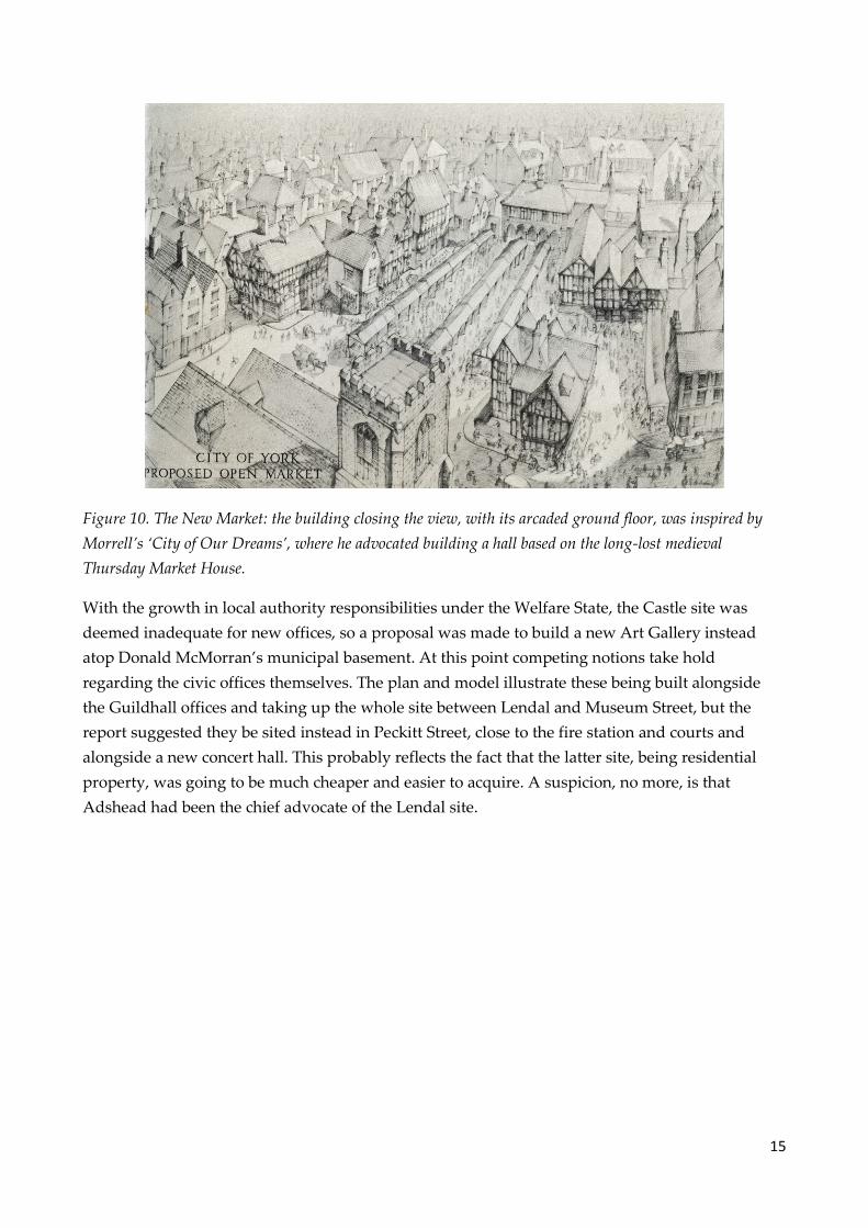
15
Figure 10. The New Market: the building closing the view, with its arcaded ground floor, was inspired by
Morrell’s ‘City of Our Dreams’, where he advocated building a hall based on the long-lost medieval
Thursday Market House.
With the growth in local authority responsibilities under the Welfare State, the Castle site was
deemed inadequate for new offices, so a proposal was made to build a new Art Gallery instead
atop Donald McMorran’s municipal basement. At this point competing notions take hold
regarding the civic offices themselves. The plan and model illustrate these being built alongside
the Guildhall offices and taking up the whole site between Lendal and Museum Street, but the
report suggested they be sited instead in Peckitt Street, close to the fire station and courts and
alongside a new concert hall. This probably reflects the fact that the latter site, being residential
property, was going to be much cheaper and easier to acquire. A suspicion, no more, is that
Adshead had been the chief advocate of the Lendal site.

16
Figure 11. One of Stanley Adshead’s perspective sketches, showing a pedestrian walk extending past the
Guildhall along the north-east bank of the Ouse.
It was not easy to identify space for major new buildings within the city centre, but an office site
was identified in the Little Stonegate/Swinegate area, while the strip between North Street and the
river was earmarked for offices with a hotel in a garden setting stretching from the Ouse to
Rougier Street at the west end. A scheme originally proposed by G.T. Andrews more than a
century earlier resurfaced at Piccadilly with the suggestion that its Foss bank should be landscaped
and buildings confined to the opposite side of the road, the majority to be new housing evidently
framing the recently-built labour exchange.
Figure 12. A detail of the model of the city centre which accompanied the 1948 exhibition

17
The Railway Station
Only in one area does the concept of the city centre’s green belt seriously break down: at the south-
west corner of the city walls, where the ring road is squeezed between these and the 1877 railway
station. To mitigate this, the authors suggested demolishing the station and rebuilding it further
back. Since the station is built on a curve this would have entailed the costly resiting of most of the
premises behind: goods station, coal depot and engine shed. They may have been encouraged in
their ideas by the 1942 Baedeker raid which badly damaged the engine sheds, left half of the great
arched trainshed burned out and a substantial part of the station offices destroyed.
However, the reality was very different. The London & North Eastern Railway had built
additional platforms just before the War and a thorough repair of the damaged trainshed was
begun soon after, in 1946. Their plans for further improvement included alterations to the frontage
but certainly did not envisage setting it back. So, even considered as part of a long-term planning
framework, this proposal had little chance of being accomplished. Strangely, it resurfaced in
Morrell’s 1955 edition of City of Our Dreams, yet he also referred to the existing building as ‘one of
the finest railway stations in the country if any of these Victorian buildings, with their iron roofs,
can be called fine.’ Twenty years later, the architectural historian John Harvey was to describe the
building as ‘one of York’s greatest blessings and noblest creations.’
Figure 13. The proposals for the area near the railway station show a new station set well back behind a
forecourt flanked by buildings for the station hotel (right) and the Railway Institute (left), the latter having a
new parcels office on the ground floor. The hotel would have lost most of its garden to the ring road, with
new public gardens being created on the opposite side of that road. The Beaux-Arts formality of the scheme
looks well on paper but totally ignores the reality of the environmental impact of a busy road intended to
form a city-centre bypass. Unsurprisingly, the 1841 railway station (the present Council headquarters) and
accompanying buildings would be cleared to make way for a new bus station and additional offices for the
London & North Eastern Railway, framing a re-sited railway war memorial. The first (1839) railway arch

18
through the city walls is shown as the access between the ring road and bus station. Queen Street becomes a
cul-de-sac serving a new office development in the wedge between Blossom Street and the ring road.
An alternative was for the ring road to cross the railway twice and go round the back of the
station. This would have been a costly road to build but less so, and far less disruptive, than the
wholesale resiting of railway facilities, while the station front could easily have been served by a
slip road. That this wasn’t even put forward as an alternative in 1948 indicates the extent to which
the new road heading past a new station was conceived in primarily visual terms as a classic piece
of Beaux-Arts planning. Indeed, this could be a valid criticism of the Plan as a whole and one
implied in the less-than-enthusiastic review which it received in the RIBA Journal of June 1948.
Figure 14. A view along the ring road with the new railway station on the left. The perspective is very
distorted, implying a vastly greater distance between the station and the river than is actually the case.
Interestingly, the new station is depicted as an essay in modernised neo-Georgian but with an arched
trainshed, which was evidently still felt to be a necessary status symbol.
What Happened?
By the time Minter and Needham presented the Central Area plan to the public in 1948, wartime
hopes for urban regeneration were up against the realities of an impoverished peacetime economy,
and they wrote that ‘the high hopes of the first months of peace have given way to a prospect of
further making do, so that the actual carrying out of any large scale improvements seems as far off
as ever.’ Having already endorsed the inner ring road proposal, the Corporation went on to
approve the detailed development plan subsequently developed by Minter. This underlay official
thinking for many years but gradually important elements such as the civic forum near the castle
simply faded away.
The inner ring road concept lived on and some demolitions took place to facilitate it. A revised
alignment was adopted in 1971, which spared a number of by-then listed buildings and went

19
round the back of the railway station, but the proposal had become highly controversial and was
finally defeated in 1975. Clifton Bridge, opened in 1963, implemented a part of the pre-war outer
ring road design but the 1948 outer ring scheme was scaled down in execution.
It is appropriate to cite John Shannon, for so many years chairman of York Civic Trust, writing in
1987. He was not referring to the 1948 Plan per se, but his remarks are highly relevant. ‘This leads
me to describe another marked characteristic of the city [York], which is the extent to which is has
retained its human scale. It is unique among the cities of the United Kingdom in that it contains a
more complete cycle of English architecture of all ages than any other city.’ The latter would
certainly not be true had the clearances for the green belt gone ahead (as it was substantial areas of
perfectly good terraced housing were destroyed) while the isolation of the historic centre from its
surroundings would surely have undermined the sense of scale.
Notes
The illustrations are taken from the 1948 plan, with minimal editing. Figures 2 and 3 (along with
numbers 5 to 7, which are details from them) have been rendered from colour into greyscale.
1 Under which the Corporation set up a local Board of Health in 1850.
2 York Corporation Streets and Buildings Committee, 14 September 1937.
3 An appealing insight into Adshead is given by the portion of a projected autobiography which appeared as:
Alan Powers (ed), ‘Architects I have known: The architectural career of S. D. Adshead’, Architectural History
vol. 24, Society of Architectural Historians of Great Britain, 1981.
4 Professor Adshead, A New England, Frederick Muller Ltd., London, 1941. Powers op. cit. note 3, p. 105.
5 York Corporation Streets and Buildings Committee, 23 September 1943 had recommended adoption of
Adshead and Needham’s inner ring road alignment, prepared in consultation with Minter, which full
Council endorsed in January 1944. The Committee’s 9 January 1945 meeting was arranging for Adshead and
Needham to report on their ‘master plan’, which had then reached maturity.
6 The most accessible form of the plan is the booklet, A Plan for the City of York, published to accompany an
exhibition of the city-centre proposals in 1948.
7 RIBA Journal vol. 69, p. 224, contains an obituary of Needham (who died on 17 April 1962) by H.H. White.
8 See, for example, the account by Patrick Nuttgens in the York Georgian Society’s Annual Report for 1991.
Dates of appointment taken from York Corporation minutes.
9 Bill Fawcett, ‘The Municipal Offices at York Castle’, York Historian vol. 23, Yorkshire Architectural and York
Archaeological Society, 2006.A Journal vol. 69, p. 224, contains an obituary of Needham (who died on 17 April
1962) by H.H. White.
10 York Corporation Finance and General Purposes Committee, 19 December 1941 (chaired by J. B. Morrell)
proposed this in response to a suggestion by the York and East Yorkshire Architectural Society and full

20
Council endorsed this on 5 January. Morrell was the chairman of the new Committee and Councillor
Willsden was vice-chairman.
11 York Corporation Streets and Buildings Committee, 9 March 1943. A partial release was also obtained for
Needham from his wartime duties as a Major in the Royal Engineers planning camps for the army’s
Northern Command.
12 York Corporation Streets and Buildings Committee, 11 April 1944 had decided, following advice by
Adshead, Needham and Minter, to recommend abandonment of the pre-war alignment of the Outer ring
road. Full Council eventually approved this once it had been established that the Ministry of War Transport
would still pay the agreed grant towards the sections already built.


![THE EMPLOYEES’ STATE INSURANCE ACT, 1948 - Bihlabour.bih.nic.in/Acts/ESI-Act-1948.pdf · THE EMPLOYEES’ STATE INSURANCE ACT, 1948 [Act No. 34 of 1948]1 [19th April, 1948 An Act](https://static.fdocuments.in/doc/165x107/5e166d21947fd14ab06fba95/the-employeesa-state-insurance-act-1948-the-employeesa-state-insurance-act.jpg)
![The Employees State Insurance Act 1948 - ... State Insurance Act 1948... · THE EMPLOYEES' STATE INSURANCE ACT, 1948 ACT NO. 34 OF 1948 1* [19th April, 1948.] An Act to provide for](https://static.fdocuments.in/doc/165x107/5aa59b087f8b9ab4788d5d44/the-employees-state-insurance-act-1948-state-insurance-act-1948the-employees.jpg)


![Factories Act, 1948 - Jharkhandshramadhan.jharkhand.gov.in/ftp/WebAdmin/documents/... · THE FACTORIES ACT, 1948 ACT NO. 63 OF 1948 1* [23rd September, 1948.] An Act to consolidate](https://static.fdocuments.in/doc/165x107/5ebaa0b53dd9ea6e29246951/factories-act-1948-the-factories-act-1948-act-no-63-of-1948-1-23rd-september.jpg)