A-I Trip A GLACIAL GEOLOGY OF THE WESTERN FINGER LAKES...
22
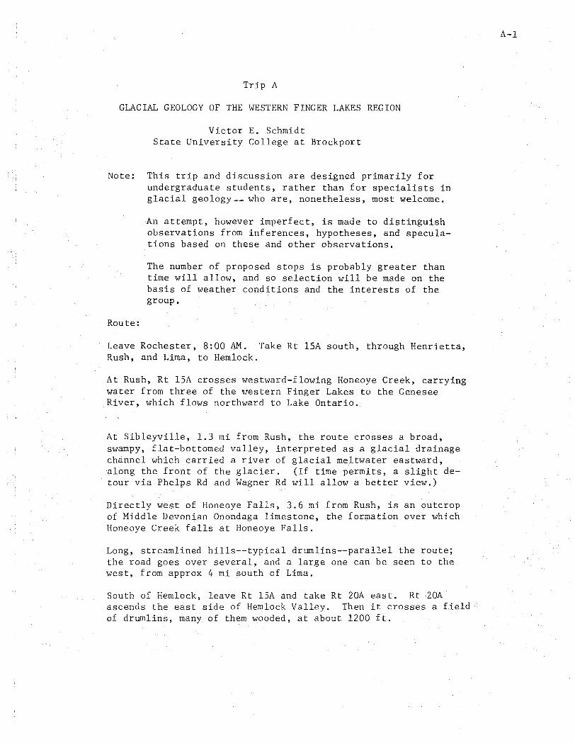
Trip A GLACIAL GEOLOGY OF THE WESTERN FINGER LAKES REGION Victor E. Schmidt State University College at Brockport Note: This trip and discussion are designed primarily for undergraduate students, rather than for specialists in glacial geology __ who are, nonetheless, most welcome. Route: An attempt, however imperfect, is made to distinguish observations from inferences, hypotheses, and specula- tions based on these and other observations. The number of proposed stops is probably greater than time will allow, and so selection will be made on the basis of weather conditions and the interests of the group. Leave Rochester, 8:00 AM. Take Rt ISA south, through Henrietta, Rush, and Lima, to Hemlock. At Rush, Rt lSA crosses westward-flowing Honeoye Creek, carrying water from three of the western Finger Lakes to the Genesee River, which flows northward to Lake Ontario. At Sibleyville, 1.3 mi from Rush, the route crosses a broad, swampy, flat-bottomed valley, interpreted as a glacial drainage channel which carried a river of glacial meltwater eastward, along the front of the glacier. (If time permits, a slight de- tour via Phelps Rd and Wagner Rd will allow a better view.) Directly west of Honeoye Falls, 3.6 mi from Rush, is an outcrop of Middle Devonian Onondaga limestone, the formation over which Honeoye Creek falls at Honeoye Falls. Long, streamlined hills--typical drumlins--parallel the route; the road goes over several, and a large one can be seen to the west, from approx 4 mi south of Lima. South of Hemlock, leave Rt lSA and take Rt 20A east. Rt20A ascends the east side of Hemlock Valley. Then it crosses a field of drumlins, many of them wooded, at about 1200 ft. A-I
Transcript of A-I Trip A GLACIAL GEOLOGY OF THE WESTERN FINGER LAKES...
Trip A
GLACIAL GEOLOGY OF THE WESTERN FINGER LAKES REGION
Victor E. Schmidt State University College at Brockport
Note: This trip and discussion are designed primarily for undergraduate students, rather than for specialists in glacial geology __ who are, nonetheless, most welcome.
Route:
An attempt, however imperfect, is made to distinguish observations from inferences, hypotheses, and speculations based on these and other observations.
The number of proposed stops is probably greater than time will allow, and so selection will be made on the basis of weather conditions and the interests of the group.
Leave Rochester, 8:00 AM. Take Rt ISA south, through Henrietta, Rush, and Lima, to Hemlock.
At Rush, Rt lSA crosses westward-flowing Honeoye Creek, carrying water from three of the western Finger Lakes to the Genesee River, which flows northward to Lake Ontario.
At Sibleyville, 1.3 mi from Rush, the route crosses a broad, swampy, flat-bottomed valley, interpreted as a glacial drainage channel which carried a river of glacial meltwater eastward, along the front of the glacier. (If time permits, a slight detour via Phelps Rd and Wagner Rd will allow a better view.)
Directly west of Honeoye Falls, 3.6 mi from Rush, is an outcrop of Middle Devonian Onondaga limestone, the formation over which Honeoye Creek falls at Honeoye Falls.
Long, streamlined hills--typical drumlins--parallel the route; the road goes over several, and a large one can be seen to the west, from approx 4 mi south of Lima.
South of Hemlock, leave Rt lSA and take Rt 20A east. Rt20A ascends the east side of Hemlock Valley. Then it crosses a field of drumlins, many of them wooded, at about 1200 ft.
A-I
Scale l' 2:'0,000
C=::EE"?==C::=:EE"?====OE==========C==========li:0
==========~li5===========2i:0=======-====:J===325 Miles 5 ° 10 J 5 20 25 30 35 Kilometers
C:::EE=S=~:EE=S==J=======t========E~===~==========~======~======~=====~ 5000 ° 5000 JOOOO 15000 20000 25000 30000 35000 Yards E3 H
CONTOUR INTERVAL 100 FEET DATUM IS MEAN SEA LEVEL

Stop I
Rt 20A between Hemlock and Honeoye, 2.5 mi east of jct with Rt IsA. (Bus to let group off on left side of road, opposite bedrock exposure; then to wait on left side of road beyond road cut ahead.)
Bedrock exposure:
Shale of the Sonyea Group, Upper Devonian. Note bedding, joints, and concretions. Are there any fossils?
Questions:
How resistant is this shale to weathering? How resistant would it have been to glacial abrasion; to glacial plucking?
Road cut:
Cut in the south end of a drumlin. An unsorted mixture of rock material, from clay-size to boulders. Much dark gray shale and clay. Many exotic rocks. Many stones show scratches.
Exotic stones: (Possibly groups determine percentages) Composition - crystalline_s __ : red sandstones
limestones and dolomites : others % Shape - well rounded ___ : subrounded
subangular ___ : angular ___ % With scratches %
What is the fabric of this material, if any? (Possible demonstration. )
Inferences:
The material is lodgment till which includes much ground-up and broken-up "local" shale. This till was deposited beneath an actively moving glacier. Well rounded, yet scratched, pebbles represent glacially transported and abraded streambed or lakeshore gravel.
The drumlir.s were formed by the "plastering" of till on bedrock. Their streamlining is a result of shaping by delicate adjustment of deposition and erosion (re-erosion?) to such conditions as load, velocity, pressure, and temperature of the bottom ice,
Route continued:
Stay on Rt 20A, which descends the west side of Honeoye Valley, At Honeoye, leave Rt 20A and turn south on West Lake Rd (County Rd 36),
Honeoye Lake, one of the smallest Finger Lakes, drains northward into the Genesee River, Deltas show on both sides of the lake; the largest, California Point, on this side, has a trailer "park",
How does the spacing of the cottages appeal to you?
A-3
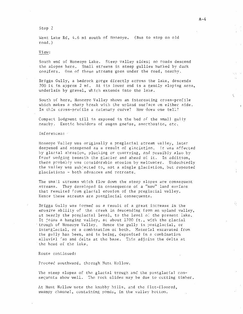
Stop 2
West Lake Rd, 4.6 mi south of Honeoye. road. )
View:
(Bus to stop on old
South end of Honeoye Lake. Steep valley sides; no roads descend the slopes here. Small streams in steep gullies marked by dark conifers. One of these streams goes under the road, nearby.
Briggs Gully, a bedrock gorge directly acyoss the lake, descends 700 ft in approx 2 mi. At its lower end is a gently sloping area, underlain by gravel, which extends into the lake.
South of here, Honeoye Valley shows an interesting cross-profile which makes a sharp break with the upland surface on either side. Is this cross-profile a catenary curve? How does one tell?
Compact lodgment till is exposed in the bed of the small gully nearby. Exotic boulders of augen gneiss, anorthosite, etc.
Inferences:
Honeoye Valley was originally a preglacial stream valley, later deepened and steepened as a result of glaciation. It was affected by glacial abrasion, plucking or quarrying, and possibly also by frost wedging beneath the glacier and ahead of it. In addition, there probably was considerable erosion by meltwater. Undoubtedly the valley was subjected to, not a single glaciation, but repeated glaciations - both advances and retreats.
The small streams which flow down the steep slopes are consequent streams. They developed in consequence of a "new" land surface that resulted from glacial erosion of the preglacial valley. Hence these streams are postglacial consequents.
Briggs Gully was formed as a result of a great increase in the erosive ability of the creek in descending from an upland valley, at nearly the preglacial level, to the level of the present lake. It joins a hanging valley, at about 1700 ft., with the glacial trough of Honeoye Valley. Hence the gully is postglacial, or interglacial, or a combination of both. Material excavated from the gully has been, and is being, deposited in a combination alluvial fan and delta at the base. This adjoins the delta at the head of the lake.
Route continued:
Proceed southward, through Hunt Hollow.
The steep slopes of the glacial trough and the postglacial consequents show well. The rock slides may be due to cutting timber.
At Hunt Hollow note the knobby hills, and the flat-floored, swampy channel, containing ponds, in the valley bottom.
A-4
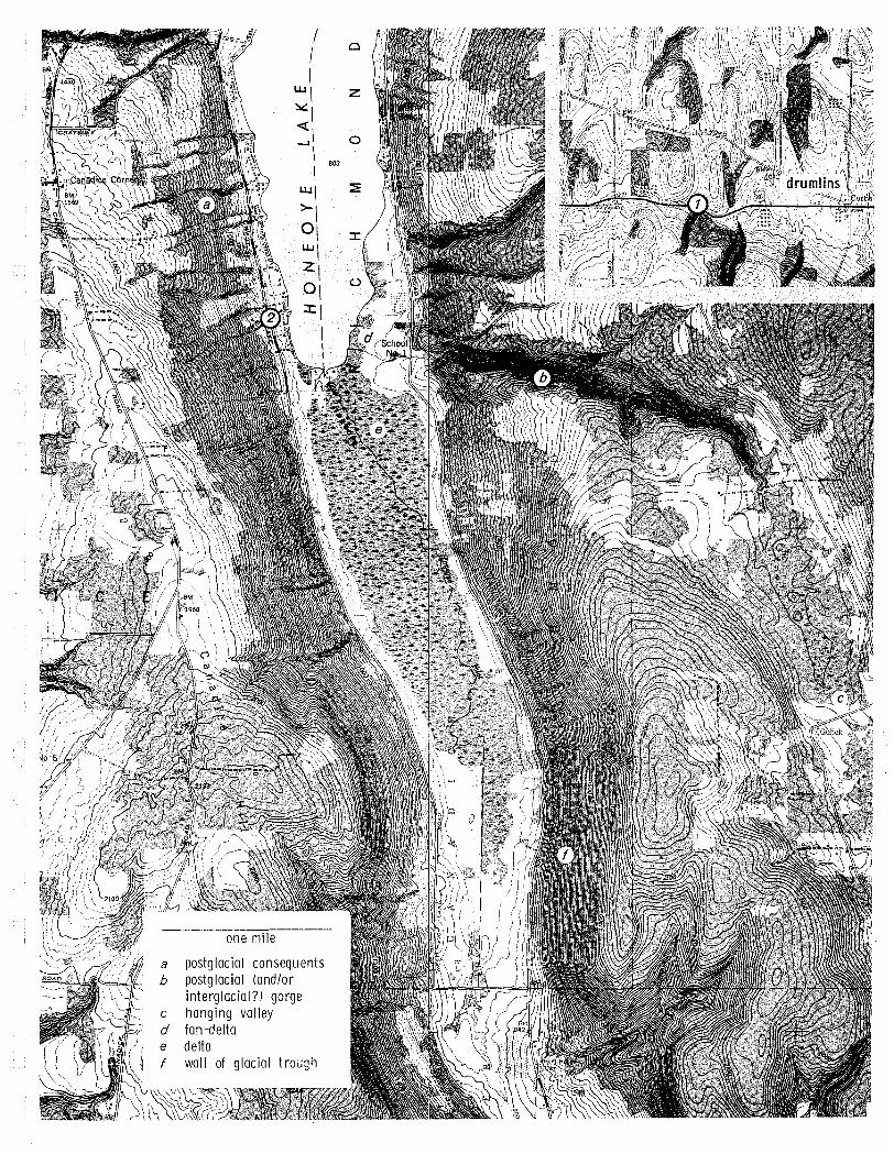
one mile
a postglacial consequents b postglacial (and/or
interglacial?) gorge c hanging valley d fan-delta e delta f wall of glacial trough
Stop 3
West Lake Rd, approx 12.7 mi south of Honeoye, 0.1 mi west of jct with French Hill Rd. (Bus to park on shoulder, or on French Hill Rd.)
Road cut and hillside:
Gravel and sorted sand. Many pebbles, especially exotics, are well rounded. Many are scratched, including some that are well rounded. Are there any indications of the direction of water flow?
Knobby hills, with "dimples", similar to the hilly topography in Honeoye Valley between Junt Hollow and here.
The hilltop affords an overlook of the flat-floored, swampy channel noted previously along the road northwest of here. This channel curves around the far side of the wooded hill ahead (SSW). The topographic map (Naples, 7.5') shows the relationship clearly. Almost the same situation occurs about 0.5 mi to the east.
In the distance are high bedrock hills: Hatch Hill (ESE), above Naples, at 1800+ ft; Knapp Hill (SE) at 2040+ ft; Pine Hill (S) at 2040+ ft; unnamed hill (SSW) above Atlanta, at 2012 ft. Valleys between these hills include: Canandaigua Valley, south end between here and Hatch Hill; Cohocton Valley, north end between Pine Hill and the hill above Atlanta; North Cohocton-Dansville Valley, east end this side of the hill above Atlanta.
At the junction of these valleys is a large area of knobby topography. Much higher and nearer is a flat-topped gravel terrace.
Inferences:
The material in the road cut is moralnlC. Much of it, at least, was deposited by meltwater, possibly in standing water of an icemargin or preglacial lake. The knobs and "dimples" on the hillside represent a constructional slope of the moraine.
The flat-floored channel is the spillway of a proglacial lake, at 1140+ ft, in the Honeoye Valley. The wooded hill ahead is a "runaround hill'; or umlaufberg - probably a knob of bedrock isola ted by the proglacial lake overflow when its former course was blocked on this side by ice or morainic material.
Route continued:
Go eastward, descending into Naples, at the southwest end of Canandaigua Valley. Continue northward on Rt 21 through Naples; then bear left on Bristol Springs Rd (County Rd 12).
West of Naples, at the mouth of Grimes Gully, D. D. Luther found the "Naples Tree" in 1882. This is the "trunk" of a lycopod or club moss, 16t ft long, of Upper Devonian age, now on display in the New ~ork State Museum in Albany.
A-6
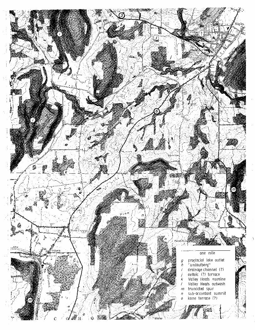
one mile
g proglacial lake outlet h "U m laufbe rg" i drainage channel (?) j deltaic (?) terrace k Valley Heads moraine / Valley Heads outwash m t ru ncated spu r n sub-accordant summit
kame terrace (?)
Stop 4
Bristol Springs Road (County Rd 12) 2 mi north-northeast of Naples, 1.5 mi north of jct with Rt 21. (Bus to stop on east side of road).
Overlook: (at vineyard of Mr. David Gentner)
South end of Canandaigua Lake, with Parish Flat and West River Valley. West River, flowing from the northeast, makes a barbed junction with northward-draining Canandaigua Valley.
Small postglacial consequent streams descend the steep sides of the valleys in small ravines, marked by dark conifers.
Parish, or Conklin, Gully (SE) is a bedrock gorge, with a gravel pit near its base. The gorge ends at a broad, semicircular area of gently and uniformly sloping farmland.
Inferences and comments:
The barbed junction of West River Valley and Canandaigua Valley supports the concept of ancient south-flowing consequent drainage of this region, later reversed as a result of stream capture or the blockage of valleys by glacial deposits. Fairchild inferred that, during Tertiary times, the Canandaigua Valley drained into the west-flowing Dansville River; at the present site of Sonyea this joined the obsequent, north-flowing Genesee River, and then continued northward to the subsequent Ontarian River (1926, p. 224 and Plate 84).
Parish Flat is a modern delta deposited at the head of Canandaigua Lake. The gentle slope at the base of Conklin Gully is on an alluvial fan. The gravel being excavated near the base of Conklin Gully may be part of a delta built by this stream into a proglacial lake that occupied the valley to this height when drainage to the north was blocked by glacial ice. More likely, it is in a kame terrace built between stagnant ice in the valley and the bedrock side of the valley. There is a bench partway up the valley side along Conklin Gully, but its cause is not known. It may be due to resistant bedrock, or possibly is a higher delta or kame terrace.
Note the attempts by man to "improve" Canandaigua Lake and its environs by bulldozing shale from the slope into the lake, allowing more cottages to be built. Fortunately, this endeavor seems to have been stopped by New York State. But others continue!
Route continued:
Proceed northward to Bristol Springs and Ontario County Park.
Lunch stop coming up.
A-8
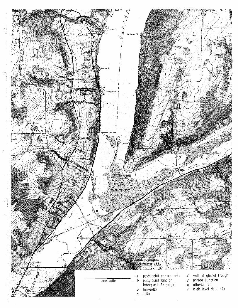
a postglacial consequents f wall of glacial trough one mile b postglacial (and/or p barbed ju nction
i nterg lac ial?) gorge q alluvial fan d fan-delta r high-level delta (?)
e delta
Stop 5 (Lunch stop)
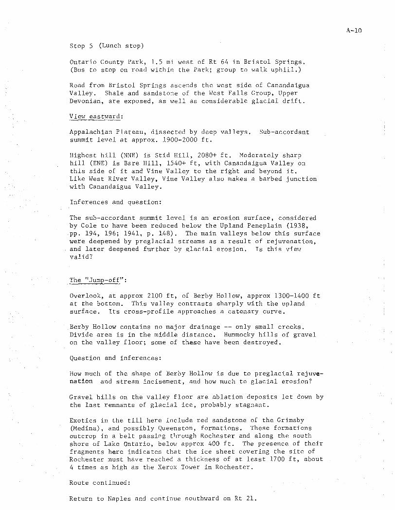
Ontario County Park, 1.5 mi west of Rt 64 in Bristol Springs. (Bus to stop on road within the Park; group to walk uphill.)
Road from Bristol Springs ascends the west side of Canandaigua Valley. Shale and sandstone of the West Falls Group, Upper Devonian, are exposed, as well as considerable glacial drift.
View eastward:
Appalachian Plateau, dissected by deep valleys. Sub-accordant summit level at approx. 1900-2000 ft.
Highest hill (NNE) is Stid Hill, 2080+ ft. Moderately sharp hill (ENE) is Bare Hill, 1540+ ft, with Canandaigua Valley on this side of it and Vine Valley to the right and beyond it. Like West River Valley, Vine Valley also makes a barbed junction with Canandaigua Valley.
Inferences and question:
The sub-accordant summit level is an erosion surface, considered by Cole to have been reduced below the Upland Peneplain (1938, pp. 194, 196; 1941, p. 148). The main valleys below this surface were deepened by preglacial streams as a result of rejuvenation, and later deepened further by glacial erosion. Is this view valid?
The "Jump-off":
Overlook, at approx 2100 ft, of Berby Hollow, approx 1300-1400 ft at the bottom. This valley contrasts sharply with the upland surface. Its cross-profile approaches a catenary curve.
Berby Hollow contains no major drainage Divide area is in the middle distance. on the valley floor; some of these have
Question and inferences:
-- only small creeks. H~~mocky hills of gravel been destroyed.
How much of the shape of Berby Hollow is due to preglacial rejuvenation and stream incisement, and how much to glacial erosion?
Gravel hills on the valley floor are ablation deposits let down by the last remnants of glacial ice, probably stagnant.
Exotics in the till here include red sandstone of the Grimsby (Medina), and possibly Queenston, formations. These formations outcrop in a belt passing tllrough Rochester and along the south shore of Lake Ontario, beloH approx 400 ft. The presence of their fragments here indicates that the ice sheet covering the site of Rochester must have reached a thickness of at least 1700 ft, about 4 times as high as the Xerox Tower in Rochester.
Route continued:
Return to Naples and continue southward on Rt 21.
A-lO
..
one mile
hanging valley f wall of glacial trough n sub-accordant summit r high -level delta (7)
profile A - B • /' ... (2x hor.; 4x vert.) / '" _/" ." ,'/
..."", -,''''' """ ..... ~ j$lfll
~.-.==-.--' catenary curve (chain)
profile A - B (2x; no vert. exag.)
. .. catenary cu rve (chain)
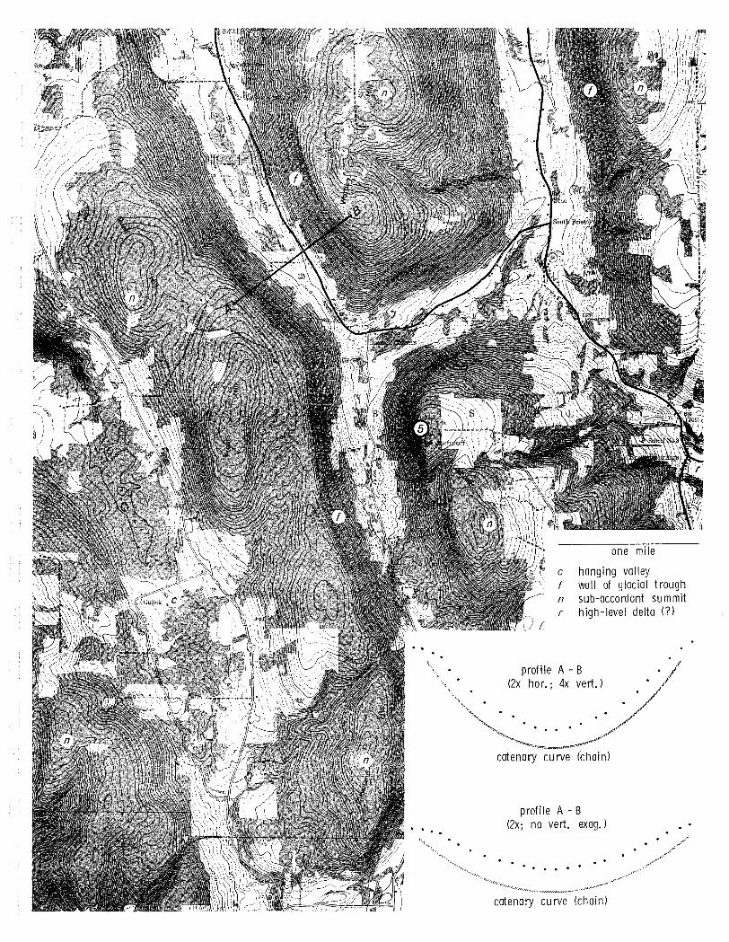
Stop 6 (See map on page 7).
Rt 21, 2 mi southwest of Naples, 1.4 mi southwest of jct with Rt 53. (Bus to stop on left side of road, at little hill with power pole.)
Road cut and vantage point:
Unsorted mixture of clay-size to cobble-size material. Many exotic rocks. Limestones, especially, show scratches. Calcareous nodules (concretions?) also occur in the material. The stones consist of -- crystallines ____ : red sandstones ____ :
carbonates ____ : local gray siltstones and sandstones % Approx ____ % show scratches.
Hummocky topography, with many hollows, covers a large area between bedrock hills, at the junction of the major valleys.
Three terraces visible in distance: largest, wooded (E of N) at 1100-1120 ft; smallest (N) at 1200 ft; highest (NNW) at 1340 ft;
Inferences and questions:
Material in road cut is till, possibly containing much scraped-up proglacial lake clay. Hummocky topography marks an end moraine, probably correlative with similar moraines at the heads of other Finger Lakes valleys, named the Valley Heads Moraine by Fairchild (1926, p. 226 and Plate 88). This moraine was deposited during a several-hundred-year time of balance between forward movement and the backward melting of the ice, during the last general recession. C-14 dates indicate this may have taken place as recently as 12000 years BP. (What are the most recent data?)
What is the origin of the calcareous nodules? Howald are they?
The terraces are possibly high-level deltas deposited in three different levels of proglacial lakes occupying this valley while drainage toward the north was blocked by ice. If so, one or more of them may have been deposited by outflow from a proglacial lake in Honeoye Valley. However, these terraces may instead be kame terraces, deposited between stagnant ice and the valley side, possibly ice-margin deltas built by meltwater streams.
Route continued:
Proceed westward and southwestward across the Valley Heads Moraine, toward Atlanta, and then westward on Sawdust Rd (County Rd 36).
Note morainic topography, including kettles. A flat-bottomed channel runs southwestward along the west side of the valley. Fairchild identifies this as the spillway over the moraine of Lake Naples, a proglacial lake in the south end of the Canandaigua Valley (1895, p. 362), presumably post-Valley Heads in age.
Immediately south of the moraine, the route crosses the North Cohocton-Dansville Valley, floored by gravel, probably outwash.
A-12
Stop 7
Black Creek Rd, 2 mi west of Atlanta, 0.4 mi south of jct with Sawdust Rd (County Rd 36). (Bus to stop on shoulder, before marsh. )
Blackcrick Hollow:
Steep-walled north-south gorge. Flat, swampy floor south of the divide at 1460+ ft. Bedrock exposed in walls. Alluvial fans at the base of tributary streams.
Inferences and questions:
This is a marginal drainage channel or glacial lake spillway (How does one tell the difference?), formed by meltwater erosion of a preglacial valley or col. (How much lowering of the preglacial divide is indicated? Can this be estimated from the map?)
If this channel is the former spillway of a proglacial or icemargin lake, presumably in the North Cohocton-Dansville Valley, at 1460+ ft, what kept the lake from escaping through the southwarddraining Cohocton Valley? Possibilities include:
a) Stagnant ice blocking the Cohocton Valley at, or south of, North Cohocton and Atlanta.
b) The end of a lobe of ice, possibly the Canandaigua lobe at North Cohocton, or the Keuka lobe at Bath, blocking the Cohocton Valley during or before Valley Heads time.
c) Valley Heads or "advance" Valley Heads end moraine, or even earlier end moraine (Arkport or Almond?), blocking the Cohocton Valley south of North Cohocton.
Is it just happenstance that a pitted gravel terrace (kame terrace or delta?) on the north side of the North Cohocton-Dansville Valley, nearly opposite Blackcrick Hollmv, attains the same elevation (1460+ ft) as the divide in Blackcrick Hollow?
Route continued:
Keep going south through Blackcrick Hollow to Cohocton.
The Blackcrick Hollow drainage channel or spillway seems to lead toward a series of gravel terraces on the west side of the Cohocton Valley, north, west, and especially south of Cohocton. Some of these attain elevations of 1480+ ft and possibly more.
What is the nature of these terraces? Are they deltas, kame terraces, outwash, or what? Why are there several levels? What caused the concavely curved bank at one level, visible from Loon Lake Rd, Rt 371, just west of Cohocton? Later, if time permits, these features will be seen and discussed.
A-13
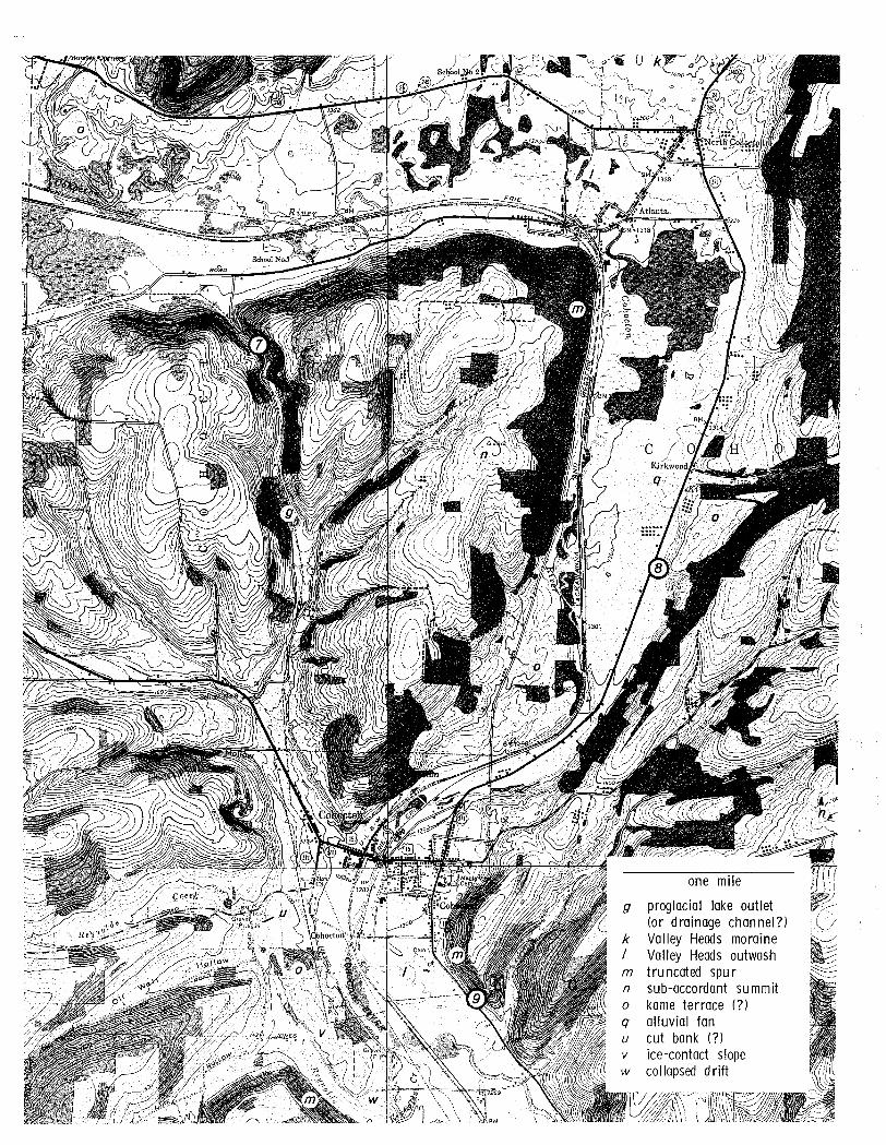
one mile
g proglacial lake outlet (or drainage channel?)
k Valley Heads moraine / Valley Heads outwash m t ru ncated spu r n sub-accordant su mmit a kame terrace (?) q alluvial fan u cut bank (?) v ice-contact slope
collapsed drift
Stop 8
East side of Rt 371, 2 mi north-northeast of Cohocton, south of the mouth of Kirkwood Gully.
Terrace and gravel pit~ (on property of Mr. Myron Crouch)
Somewhat sorted and stratified "bright" gravel and sand. A great variety of exotic rocks. Pebbles mostly well rounded. Well rounded boulders of resistant crystalline rocks; poorly rounded blocks of local sandstone. Many "ghost" pebbles of weathered carbonates, including cherty Onondaga limestone.
The pebbles consist of -- crystallines ___ : red sandstones ___ : carbonates ___ : local gray siltstones and sandstones ___ %
They are -- well rounded ___ : subrounded subangular ___ : angular ___ % The depth of leaching of the gravel is ft.
The face of the terrace is fairly straight, but shows some "dimples". A similar terrace, with kettles, occurs on the opposite side of the valley, toward the southwest.
Inferences and questions:
The gravel was deposited by energetic meltwater, close to the ice margin. Could it be, in part, an alluvial fan deposited by Kirkwood Creek up against glacial ice in the v~lley?
Does the terrace indicate an "advance" Valley Heads position (Muller, 1966), or is it pre-Valley Heads in age? Connally considers it to be the easternmost remnant of Arkport Moraine (1964, p. 43). Just how was it formed? Possibilities include:
a) Deposition by meltwater at the margin of an active ice tongue -- an end moraine or lateral moraine, possibly eroded later by meltwater from the Valley Heads ice.
b) Deposition by meltwater between a mass of stagnant ice and the east side of the valley -- a typical kame terrace.
c) Deposition of outwash gravel on top of buried stagnant ice in the central portion of the valley; this later melted out, causing the collapse of the gravel in the central portion, but not here at the side (Rich, 1943, p. 98).
d) Deposition of outwash gravel up to the level of the terrace, followed by dissection by a later'meltwater stream, leaving the terrace as a remnant of the former high-level outwash deposit.
Route continued:
Turn and go south on Rt 371 to Cohocton, and then on Rt 15 to rest area 0.9 mi south of Cohocton.
A-IS
Stop 9
Rest area on east side of Rt 15, 0.9 mi south of Cohocton.
View:
Cohocton Valley, an essentially straight, steep-walled, nearly northwest-southeast valley, floored by gravel. The thickness of the gravel, not known, may be obtainable from well logs.
Across the valley is a bench of gravel which attains an elevation of 1480+ ft. It is directly south of Blackcrick Hollow. The face seems to show two levels here; more north of here.
Inferences and questions:
Cohocton Valley is a "through" valley, probably eroded to a large extent by glacial meltwater, as well as by glaciers. According to Fairchild, the preglacial divide was north of Bath (1926, Plate 84). The valley shows truncated spurs, and is floored by a valley train of Valley Heads outwash. Tributary streams have built alluvial fans on top of this outwash.
The gravel bench appears to be a kame terrace, consisting of outwash gravel deposited against stagnant ice. Ice-contact surfaces show especially well on the opposite (southwest) side of the deposit, where it stands free from bedrock. At its southeast end there appears to bean area of collapsed drift.
Is it possible that this gravel bench is, instead, a delta built into a lake in the Cohocton Valley? If so, what held in the lake?
In any case, what caused the two or more levels on the deposit?
Route continued:
Turn north on Rt 15, back to Cohocton. If time permits, tn Cohocton take Rt 371 south, to stop at a pit in the gravel bench, and possibly to view ice-contact surfaces and collapse topography. If not, continue northward on Rt 15 and turn west on Hinkle Hollow Rd, 0.6 mi beyond jct of Rts 15 and 371.
Just west of Cohocton, Rt 371 ascends several terraces, one with a concavely curvec bank. Could this be the cut bank of a meander, possibly of an outwash stream flowing between ice on the east and the gravel bench on the west?
A gravel pit south of Rt 371, near jct with Oil Well Hollow Rd, shows dirty outwash gravel. Foreset bedding in sand and the dip of flat pebbles suggest water flow from the north and northwest.
If there is time, continue south on Lake Hollow Rd to view icecontact surfaces, and onto Jones Rd to see collapse topography. Then turn north on Marks Rd, to rejoin Rt 15 in Cohocton, and turn wes~ on Hinkle Hollow Rd, 0.6 mi beyond jct of Rts 15 and 371.
A-16
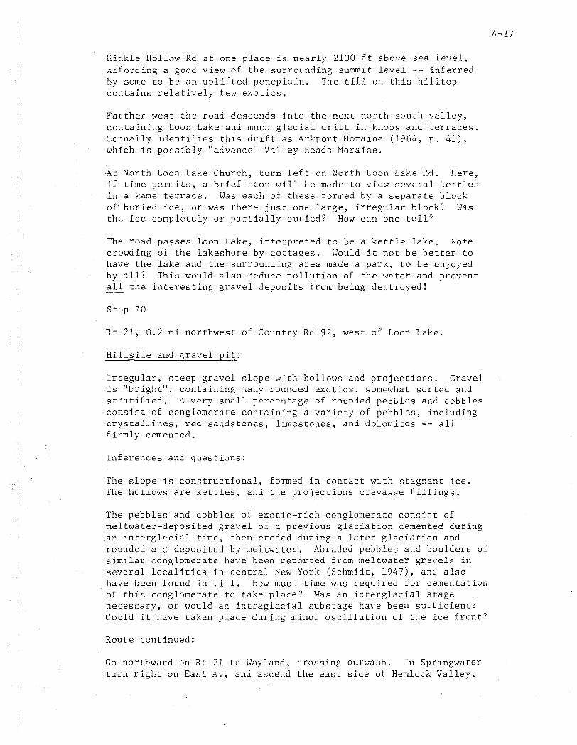
Hinkle Hollow Rd at one place is nearly 2100 ft above sea level, affording a good view of the surrounding summit level -- inferred by some to be an uplifted peneplain. The till on this hilltop contains relatively few exotics.
Farther west the road descends into the next north-south valley, containing Loon Lake and much glacial drift in knobs and terraces. Connally identifies this drift as Arkport Moraine (1964, p. 43), \vhich is possibly "advance" Valley Heads Moraine.
At ~orth Loon Lake Church, turn left on North Loon Lake Rd. Here, if time permits, a brief stop will be made to view several kettles in a kame terrace. \"as each of these formed by a separate block of buried ice, or was there just one large, irregular block? tvas the ice completely or partially buried? How can one tell?
The road crowding have the by all? all the
Stop 10
passes Loon Lake, interpreted to be a kettle lake. Note of the lakeshore by cottages. Would it not be better to lake and the surrounding area made a park, to be enjoyed This would also reduce pollution of the water and prevent
interesting gravel deposits from being destroyed!
Rt 21, 0.2 mi northwest of Country Rd 92, west of Loon Lake.
Hillside and gravel pit:
Irregular, steep gravel slope with hollows and projections. Gravel is "bright", containing many rounded exotics, somewhat sorted and stratified. A very small percentage of rounded pebLles and cobbles consist of conglomerate containing a variety of pebbles, including crystallines, red sandstones, limestones, and dolomites -- all firmly cemented.
Inferences and questions:
The slope is constructional, formed in contact with stagnant ice. The hollows are kettles, and the projections crevasse fillings.
The pebbles and cobbles of exotic-rich conglomerate consist of meltwater-deposited gravel of a previous glaciation cemented during an interglacial time, then eroded during a later glaciation and rounded and deposited by meltwater. Abraded pebbles and boulders of similar conglomerate have been reported from meltwater gravels in several localities in central New York (Schmidt, 1947), and also have been found in till. How much time was required for cementation of this conglomerate to take place? Was an interglacial stage necessary, or would an intraglacial substage have been sufficient? Could it have taken place during minor oscillation of the ice front?
Route continued:
Go northward on Rt 21 to lVayland, crossing outwash. In Springwater turn right on East Av, and ascend the east side of Hemlock Valley.
A-17
one mile
g proglacial lake outlet (or drainage channel?)
i drainage channel (?)
/ Valley Heads outwash m t ru ncoted spu r n sub-accordant su mmit 0 kame terrace (?)
u cut bank (?)
v ice-contact slope w collapsed drift x kettles
kettle lake
.,'"-,u-"-c,,'-", ;.,.f 0
y~~
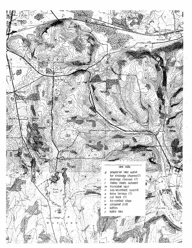
Stop 11
Straight Rd, just west of Price Rd, 1.7 mi east-northeast of Springwater. (Bus to go east on East Av, Springwater, to Price Rd, then north to Straight Rd; park on Price Rd. Group to walk downhill. )
Vantage point:
Hemlock Lake (left, NNW) and Canadice Lake (right, N). Difference in levels is obvious (905 ft; 1096 ft). These are two of the smallest Finger Lakes, and nearly the farthest west. Both drain northward to the Genesee River.
Sub:-accordant summits: hill \.;res t of Springwa ter (I~SW) 2060+ f t; Marrowback Hill (NW) 1940+ ft; Bald Hill (N) 1860+ ft. According to Fairchild, Marrowback Hill is capped by Wiscoy shale and Bald Hill by Gardeau sandstone, both Upper Devonian (1928, p. 81).
West of Springwater, a creek descends the valley side in a steep gorge.
Inferences and questions:
The apparent southward confluence of Canadice and Hemlock Valleys suggests former southward drainage, followed by reversal. Did this reversal occur preglacially, as a result of the capture of south-flowing consequent streams by an encroaching north-flowing obsequent stream? Or did it result from glacial deposition in the valleys south of the lakes? VonEngeln implies the latter, and on this basis distinguishes Finger Lakes "West" from Finger Lakes "East" (1961, pp. 27, 38-45). Well logs might throw light on this matter.
The hill summits may represent an uplifted peneplain, although they probably are considerably lower than the former level of this uplifted erosion surface, if there actually is one.
The gorge west of Springwater possibly was eroded chiefly by overflow from a proglacial lake in the south end of the valley of northflowing South McMillan Creek, on the opposite side of Marrowback Hill. In any case, the gorge is postglacial, interglacial, or both.
Route continued:
Return to Springwater, or to Rt lsA north of Springwater. Proceed north on Rt lsA to overlook of Hemlock Lake, 4.6 mi north of Springwater.
North of Springwater the road runs along the delta at the head of Hemlock Lake. It then passes over a large alluvial fan at the base of Reynolds Gully, a postglacial (or interglacial, or both?) gorge 2 mi north of Springwater.
A-19
one mile
a postglacial consequents b postglacial (and/or
interglacial?) gorge e delta f wall of glacial trough g proglacial lake outlet (?) n sub-accordant summit q alluvial fan z course of preglacial
Canad ice Creek (?)
Stop 12
Rt 15A, 4.6 mi north of Springwater
Overlook:
Hemlock Lake lies in a long, narrow, straight, essentially northsouth trough. The depth of the trough, from the top of Marrowback Hill (W) at 1940+ ft to the deepest part of the lake, 809 ft, is 1131+ ft.
Inferences and comments:
A-2l
The narrowness and straightness of this trough suggest that it was developed from a narrow valley of a relatively small stream. Possibly the trough was preceded by a narrow, steep-walled sluiceway eroded by south-surging meltwater during glacial advance.
Hemluck Lake is a major source of the Rochester area water supply. It is delightfully clear, and makes good canoeing. Note the contrast with Honeoye Lake in regard to the crowding of cottages along the lake shore. Hemlock Lake and Canadice Lake could be the start and nucleus of a Finger Lakes National Park!
Route continued:
Stay on Rt l5A to Rochester. Retracing the route north of Hemlock provides another opportunity to see the drumlins and glacial drainage channel viewed earlier, on the southbound trip.
References
Cole, W. S. 1938. Erosion Surfaces of Western and Central New York. Jour. Geol., vol. 46, pp. 191-206.
Cole, W. S. 1941. Nomenclature and Correlation of Appalachian Erosion Surfaces. Jour. Geol., vol. 49, pp. 129-148.
Connally, G. G. 1964. The Almond Moraine of the Western Finger Lakes Region, New York. Ph.D. thesis, Michigan State Univ.
Fairchild, H. L. 1895. Glacial Lakes of Western New York. Geol. Soc. Am. Bull., vol. 6, pp. 353-374.
Fairchild, H. L. 1926. The Dansville Valley and Drainage History of Western New York. Rochester Acad. Sci. Proc., vol. 6, pp. 217-242.
Fairchild, H. L. 1928. Geologic Story of the Genesee Valley and Western New York. Pub. by author, Rochester, N.Y. 215 pp.
Muller, E. H. 1966. Glacial Geology and Geomorphology between Cortland and Syracuse. Nat. Assoc. Geol. Tchrs., Eastern Sect., Field Trip Guidebook, pp. 1-15.
Rich, J. L. 1943. Buried Stagnant Ice as a Normal Product of a Progressively Retreating Glacier in a Hilly Region. Am. Jour. Sci., vol. 241, pp. 95-100.
Schmidt, V. E. 1947. Boulders of Interglacial Conglomerate in Central New York. Am. Jour. Sci., vol. 245, pp. 127-133.
von Engeln, O. D. 1961. The Finger Lakes Region: Its Origin and Nature. Cornell Univ. Press, Ithaca, N.Y. 156 pp.