
A Guide to Land Eligibility Direct Payment Schemes on land eligibility for the various area related...
29
A Guide to Land Eligibility Direct Payment Schemes 2015
Transcript of A Guide to Land Eligibility Direct Payment Schemes on land eligibility for the various area related...

A Guide to Land Eligibility
Direct Payment Schemes
2015

Page 2
Table of Contents
1 INTRODUCTION .......................................................................................................... 3
2 ELIGIBLE LAND .......................................................................................................... 4
3 INELIGIBLE LAND...................................................................................................... 5
4 AREAS REQUIRING TOTAL EXCLUSION ............................................................ 5
5 RUSHES, HEATHER AND FERNS ............................................................................ 6
5.1 RUSHES ....................................................................................................................... 6 5.2 HEATHER .................................................................................................................... 8
5.3 FERNS ....................................................................................................................... 10
6 MAINTAINING AGRICULTURAL AREAS IN A STATE SUITABLE FOR
GRAZING OR CULTIVATION ................................................................................ 12
7 DETERMINING LAND ELIGIBILITY ................................................................... 13
8 LAND PARCEL IDENTIFICATION SYSTEM (LPIS) .......................................... 14
9 COMPLETING THE APPLICATION ...................................................................... 14
10 THE REDUCTION COEFFICIENT PROCEDURE ............................................... 16
11 INELIGIBLE FEATURES OR AREAS .................................................................... 17
11.1 FARMYARDS, CONCRETED OR GRAVELLED AREAS AND FARM ROADWAYS ......... 17 11.2 PONDS, RIVERS, STREAMS ..................................................................................... 17
11.3 OUTCROPPING ROCK ............................................................................................. 17
11.4 SCRUB ................................................................................................................... 18
11.5 QUARRIES, SAND AND GRAVEL PITS ..................................................................... 19 11.6 MARSHY OR WET AREAS ...................................................................................... 19 11.7 AREAS FENCED OFF ............................................................................................... 21
11.8 UNUSED AREAS OF ARABLE PARCELS ................................................................... 21
12 BURNING ..................................................................................................................... 21
13 LANDSCAPE FEATURES ......................................................................................... 21
14 NATURA 2000 AND WATER FRAMEWORK DIRECTIVE................................ 22
15 FURTHER EXAMPLES OF LAND ELIGIBILITY ................................................ 23
16 ENVIRONMENTAL IMPACT ASSESSMENT ....................................................... 28
17 INSPECTIONS ............................................................................................................. 28
18 FARM ADVISORY SERVICE (FAS)........................................................................ 28
ANNEX 1. IMPLEMENTING LEGISLATION .............................................................. 29
Page 3
1 Introduction
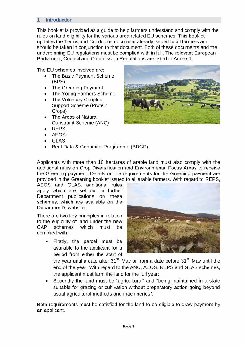
This booklet is provided as a guide to help farmers understand and comply with the rules on land eligibility for the various area related EU schemes. This booklet updates the Terms and Conditions document already issued to all farmers and should be taken in conjunction to that document. Both of these documents and the underpinning EU regulations must be complied with in full. The relevant European Parliament, Council and Commission Regulations are listed in Annex 1. The EU schemes involved are:
The Basic Payment Scheme (BPS)
The Greening Payment
The Young Farmers Scheme
The Voluntary Coupled Support Scheme (Protein Crops)
The Areas of Natural Constraint Scheme (ANC)
REPS
AEOS
GLAS
Beef Data & Genomics Programme (BDGP)
Applicants with more than 10 hectares of arable land must also comply with the additional rules on Crop Diversification and Environmental Focus Areas to receive the Greening payment. Details on the requirements for the Greening payment are provided in the Greening booklet issued to all arable farmers. With regard to REPS, AEOS and GLAS, additional rules apply which are set out in further Department publications on these schemes, which are available on the Department’s website.
There are two key principles in relation to the eligibility of land under the new CAP schemes which must be complied with:-
Firstly, the parcel must be
available to the applicant for a
period from either the start of
the year until a date after 31st. May or from a date before 31st. May until the
end of the year. With regard to the ANC, AEOS, REPS and GLAS schemes,
the applicant must farm the land for the full year;
Secondly the land must be “agricultural” and “being maintained in a state
suitable for grazing or cultivation without preparatory action going beyond
usual agricultural methods and machineries”.
Both requirements must be satisfied for the land to be eligible to draw payment by an applicant.

Page 4
The following are additional requirements at parcel level:
There must be independent and suitable access to all parcels declared for animals and/or machinery;
There must be clearly defined external boundaries except in the case of commonage. This is to facilitate the measurement of the parcel area;
There must be appropriate fencing for the farming enterprise to ensure that the applicant is in control of the parcel. Appropriate fencing means stock proof fencing which will control an applicant’s animals and also the neighbouring farmer’s animals. An exception to this rule is that the need for stock proof fencing is not required for exclusively owned hill lands, provided the lands continue to be farmed in the traditional manner by hill farmers in compliance with the requirements of the EU regulations governing the Direct Payment Schemes.
Other eligibility requirements are set out in the Terms and Conditions booklet.
In addition to the above, all applicants must comply with the Cross Compliance (including GAEC) requirements to avoid sanction. A Cross Compliance guidance booklet setting out these requirements is available on the Department’s website.
The purpose of this “Land Eligibility” booklet is to set out what is eligible agricultural land, what are ineligible land/features and what “maintaining land in a state suitable for grazing or cultivation” means in the context of declaring land eligible for payment under the Basic Payment Scheme and other Direct Payment Schemes in Ireland.
2 Eligible Land
Only “agricultural lands” are eligible. Agricultural areas used for arable crops, vegetables, nurseries and land used to grow
grass, be it
naturally occurring grass or grass grown from seed, is eligible. The definition of permanent grassland has changed under the revised CAP. Permanent grassland

Page 5
includes productive ryegrass dominated swards, less productive swards that include rush and other non grass herbaceous species and grassland that includes heather which is grazable and where grass and herbaceous species are not predominant.
In addition to the above, land which was claimed on an SPS application in 2008 and which gave rise to a payment and has been planted in subsequent years under an afforestation scheme is eligible for BPS and Greening to the person drawing the forestry premium. With regard to Natura lands or lands subject to the requirements of the Water Framework Directive (WFD), such areas which were declared on a 2008 SPS application and which gave rise to payment and parts of which had become ineligible due to compliance with SPA, SAC or WFD management requirements or ecological objectives will be eligible for payment. The area under designated landscape features, such as hedgerows and drains, is also eligible – see Section 13 for further detail.
3 Ineligible Land
Non “agricultural areas” are not eligible. Bogland whether used for turf production or not is not eligible. Blanket Bog which is used for agricultural purposes continues to be eligible. Land under forestry which was planted in 2008 or earlier is not eligible.
In addition, forestry land planted since 2008 which is not being paid forestry premium is not eligible. Native woodlands and areas under Christmas trees are not eligible. Further to the above, land which was farmed may no longer be eligible due to the encroachment of scrub. Land with heather which is not grazed and has now become mature and woody is not
eligible. This may apply to full parcels in which case the full parcel is not eligible and the claimed area must be reduced to zero. Where only part of a parcel is at issue, appropriate deductions must be made to the claimed area using the guidance provided in Section 9.
4 Areas Requiring Total Exclusion
The following are features within parcels which are not eligible:
Farmyards, concreted or gravelled area, farm roadways;
Ponds;
Rivers and streams;
Outcropping rock;

Page 6
Scrub;
Quarries, sand and gravel pits;
Marshy or wet areas;
Areas fenced off to exclude livestock;
Unused areas in arable fields.
These features will be expanded on in Section 11.
5 Rushes, Heather and Ferns
5.1 Rushes
Immature rushes are edible and may be grazed by farm animals. The development of rushes can be controlled by grazing animals or by mechanical means such as mowing/topping. However where rushes are not controlled they will proliferate and dominate the sward. This will result in the loss of grazing areas where animals no longer access them. Where this is the case the land must be deducted or a percentage reduction applied to account for the area of the parcel in this condition – see Section 9.
Ineligible rushes are defined by the following characteristics:
Tall rushes not being accessed by grazing animals;
High density of rushes and not accessed by animals.
Eligible - Rushes managed by grazing and topping

Page 7
Ineligible - Tall rushes and area not accessed by animals
Eligible - Rushes increasing in density with evidence of grazing by animals, ongoing management required to avoid the land becoming ineligible

Page 8
5.2 Heather
Low immature heather is an edible species which is grazed by mountain sheep breeds in particular, and other sheep and cattle where it occurs at lower elevations. Land with heather in this state, is eligible. Tall woody heather which is no longer being accessed by animals is not eligible. Where this is the case the land must be deducted or a percentage reduction applied to account for the area of the parcel in this condition – see Section 9.
Ineligible heather is characterized by the following:
Tall and woody;
Areas of heather not being accessed by grazing animals.
Ineligible - Tall woody heather
Eligible – but requires reductions for furze

Page 9
Eligible - Management needed to ensure it remains in an eligible state
Ineligible - Tall woody heather

Page 10
Eligible
5.3 Ferns
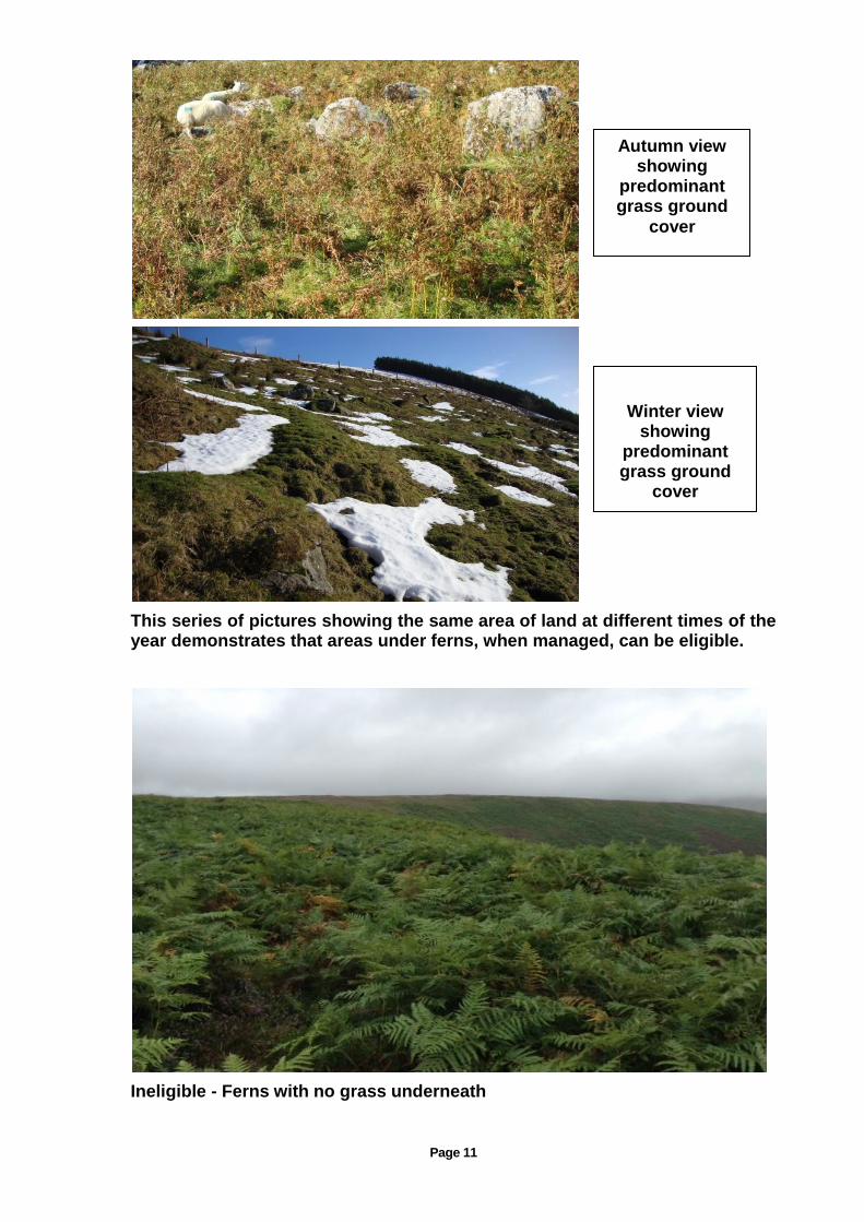
Ferns or bracken are inedible to farm animals. They emerge annually in early summer and start to die off when the first frosts arrive in autumn. Where ferns have grass underneath it will result in the land being in a grazable state. Consequently the area is eligible. Ferns with no grass underneath will not be grazable by animals and is therefore not eligible and the area must be deducted in full – see Section 9.
Summer view showing sheep
actively grazing
grassland with interspersed
ferns
Page 11
This series of pictures showing the same area of land at different times of the year demonstrates that areas under ferns, when managed, can be eligible.
Ineligible - Ferns with no grass underneath
Autumn view showing
predominant grass ground
cover
Winter view showing
predominant grass ground
cover

Page 12
6 Maintaining Agricultural Areas in a State Suitable for Grazing or Cultivation
Firstly ensure that all ineligible areas are excluded as set out below in Section 9. This may give rise to a new reference area (maximum eligible area) for the parcel. From this point on it is a matter of doing whatever is required to maintain the area in an eligible state. Existing areas of scrub must be controlled to prevent the further encroachment of briars and other woody species into the parcel. Action must be taken to prevent the development of new scrub. Hedgerows must be maintained to prevent them from expanding into the parcel. Drains must be maintained so that they continue to function and to prevent the development of ineligible wet areas within the parcel.
Where any of the lands is designated as an SAC or SPA or subject to the requirements of the Water Framework Directive, farmers must in addition adhere to the management requirements and ecological objectives for these areas.
Page 13
7 Determining Land Eligibility
1. Is the land available to
me for the prescribed
period and have I full and
independent access to the
land?
NO
Delete the
parcel from
the claim
YES
2. Is the parcel
agricultural land and
will I keep the land in
an eligible state
suitable for grazing or
cultivation throughout
the calendar year?
NO
You must
set the
claimed
area to zero
proceed to 3
YES
3 Is the
boundary of the
land correctly
shown on the
maps?
NO
Correct the
boundary and
proceed to
question 4
YES
4 Are all the buildings,
yards, roadways, ineligible
forestry, lakes, ponds,
streams and rivers
correctly redlined on the
maps and deducted?
NO
Deductions must be
made by excluding
these features in their
entirety ensuring their
boundaries are correct
and proceed to
question 5
YES
5 Are all ineligible areas
correctly redlined on the
maps and the appropriate
percentage reduction
applied?
NO
Deductions must be
made by excluding
these features using
the appropriate
percentage reduction
and ensuring their
boundaries are
correct and proceed
to 6
YES
6 Your land is
eligible for the Basic
Payment Scheme.
You are advised to
also check your
compliance with the
Cross Compliance
requirements.
Page 14
8 Land Parcel Identification System (LPIS)
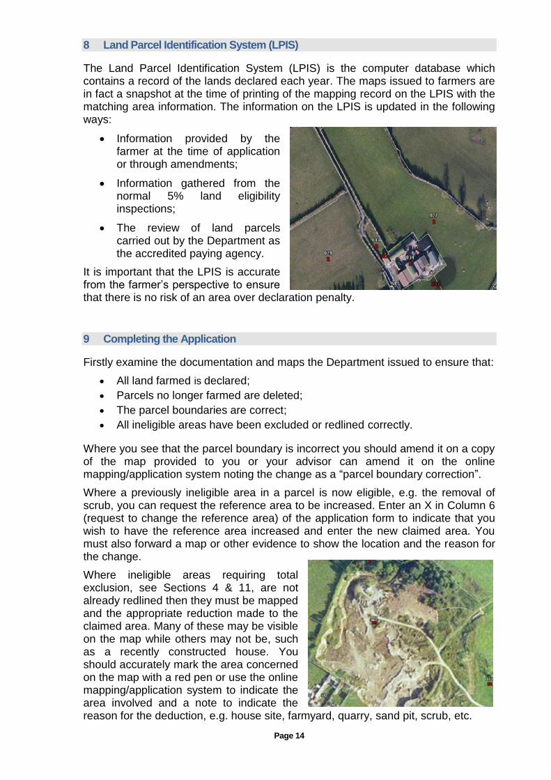
The Land Parcel Identification System (LPIS) is the computer database which contains a record of the lands declared each year. The maps issued to farmers are in fact a snapshot at the time of printing of the mapping record on the LPIS with the matching area information. The information on the LPIS is updated in the following ways:
Information provided by the farmer at the time of application or through amendments;
Information gathered from the normal 5% land eligibility inspections;
The review of land parcels carried out by the Department as the accredited paying agency.
It is important that the LPIS is accurate from the farmer’s perspective to ensure that there is no risk of an area over declaration penalty.
9 Completing the Application
Firstly examine the documentation and maps the Department issued to ensure that:
All land farmed is declared;
Parcels no longer farmed are deleted;
The parcel boundaries are correct;
All ineligible areas have been excluded or redlined correctly.
Where you see that the parcel boundary is incorrect you should amend it on a copy of the map provided to you or your advisor can amend it on the online mapping/application system noting the change as a “parcel boundary correction”.
Where a previously ineligible area in a parcel is now eligible, e.g. the removal of scrub, you can request the reference area to be increased. Enter an X in Column 6 (request to change the reference area) of the application form to indicate that you wish to have the reference area increased and enter the new claimed area. You must also forward a map or other evidence to show the location and the reason for the change.
Where ineligible areas requiring total exclusion, see Sections 4 & 11, are not already redlined then they must be mapped and the appropriate reduction made to the claimed area. Many of these may be visible on the map while others may not be, such as a recently constructed house. You should accurately mark the area concerned on the map with a red pen or use the online mapping/application system to indicate the area involved and a note to indicate the reason for the deduction, e.g. house site, farmyard, quarry, sand pit, scrub, etc.
Page 15
Where Rushes or Heather exist in a parcel you must determine if the full area of the parcel is ineligible and should be deducted in full or whether a percentage reduction should be applied to indicate the ineligible area within the parcel. Areas of Ferns with no grazable area underneath are ineligible and must be deducted in full. See Section 5.
Areas of Rock or dense Scrub with no interspersed grazing must be deducted in full. Where areas of Rock or Scrub exist within a specific area of a parcel and which are interspersed with grazing, you must determine the percentage reduction to be applied to indicate the ineligible area within that specific area of the parcel.
Where you determine that a specific area within a parcel requires a percentage reduction to be applied, i.e. only part of the area is ineligible, you should mark this area on the map with red pen or on the online application/mapping system and note the percentage reduction to apply, e.g. 20%, 40%, 80%, etc. and the reason for the reduction, e.g. scrub, rock.
Where widely scattered Rock or Scrub exists within a parcel it is acceptable to apply a percentage reduction to the whole area of the parcel, e.g. 5% reduction to apply to the whole parcel.
One of the advantages of the online mapping/application system is that when you mark the ineligible area it will give you the measured area.
Finally you should amend the claimed area of the parcels where a reduction in area is to be applied.
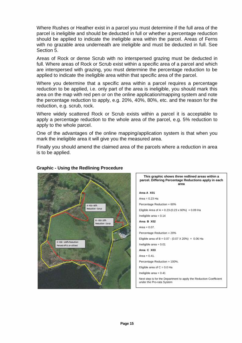
Graphic - Using the Redlining Procedure
This graphic shows three redlined areas within a parcel. Differing Percentage Reductions apply in each
area
Area A X01
Area = 0.23 Ha
Percentage Reduction = 60%
Eligible Area of A = 0.23-(0.23 x 60%) = 0.09 Ha
Ineligible area = 0.14
Area B X02
Area = 0.07.
Percentage Reduction = 20%
Eligible area of B = 0.07 - (0.07 X 20%) = 0.06 Ha
Ineligible area = 0.01
Area C X03
Area = 0.41.
Percentage Reduction = 100%.
Eligible area of C = 0.0 Ha
Ineligible area = 0.41
Next step is for the Department to apply the Reduction Coefficient under the Pro-rata System

Page 16
10 The Reduction Coefficient Procedure
EU legislation now provides for a pro-rata system to determine the payable area of parcels where areas with reductions exist within the parcels. This system will be applied by the Department to determine the payable area for each parcel being claimed.
The following table outlines the various categories of reductions to be applied under the pro-rata system.
Using the areas in Redlining Graphic above, the first step is to remove the totally ineligible area to establish the adjusted eligible area of the parcel, i.e. the reference area less the area of totally ineligible land – Step 1. The result is 2.29 ha - Step 2. Where areas of less than 100% ineligible have been identified within parcels, the ineligible area is calculated and totalled - Step 3. The overall percentage reduction is then calculated - Step 4. This figure is used to determine the appropriate category in the pro-rata table - Step 5. As 6.55% falls into Category 1, no deduction is applied to the adjusted eligible area, so it will become the new payable area for this parcel – Step 6.
Example of Application of Reduction Coefficient
Existing Reference Area of Parcel: 2.70ha
Step 1 – Deduct X03 (100% ineligible): 0.41ha
Step 2 - Adjusted Eligible Area: 2.29ha
Step 3 - Total of X01 & X02 ineligible areas: 0.15ha (0.14 +0.01)
Step 4 – Reduction Percentage of Step 3 0.15 / 2.29ha x 100 = 6.55%
Step 5 – 6.55% is in Reduction Coefficient Category 1: 0 Reduction
Step 6 – Payable Area for Parcel: 2.29 ha
As can be seen from the reduction coefficient table, where the total ineligible area within a parcel accounts for up to 10% of the area of the parcel, less the area deducted as 100% ineligible, no reduction will apply to the adjusted reference area of the parcel. Where the total ineligible area to be excluded is 70% or greater, then the full area of the parcel will be excluded from payment.
Reduction Coefficients applied under the Pro-rata System
Category
% Ineligible within the
Parcel and/or Redlined Area
Reduction Coefficient to be
applied
1 0 up to 10 0
2 10 up to 30 20%
3 30 up to 50 40%
4 50 up to 70 60%
5 70 up to 100 100%

Page 17
11 Ineligible Features or Areas
11.1 Farmyards, Concreted or Gravelled Areas and Farm Roadways
Areas under these features must be deducted in full as they are ineligible. Gravelled areas can include farmyards and areas where bales of hay, silage or straw are stored. Where farm roadways are fenced off from the adjoining
fields then the area between the fence lines is ineligible. Where the roadway runs alongside a field boundary or within a field and is open to the field, the width of the gravelled area must be deducted.
11.2 Ponds, Rivers, Streams
The areas under ponds, rivers and streams are ineligible and must be marked for exclusion. Rivers and streams are marked on the Ordnance Survey Discovery Series maps with a blue line whereas drains are not. There is no need to deduct the area under drains as they have been designated as landscape features under GAEC and as such are eligible - see Section 13.
With regards to turloughs, all areas that become available for grazing during the summer are eligible. Areas which are permanently ineligible, be it areas under water or areas too wet for grazing, must be deducted as ineligible.
Where rivers and streams are fenced to prevent damage by animals, as required under environmental schemes such as REPS, AEOS, GLAS, etc., the area inside the fence continues to be eligible.
11.3 Outcropping Rock
The area under outcropping rock is not eligible as it is not available for grazing. Rocky areas with no grazing
must be deducted as ineligible. Where the rock is interspersed with grazing areas a reduction percentage must be applied to reflect the loss in area due to the presence of the rock – see Section 9.

Page 18
11.4 Scrub
Areas under dense scrub with no interspersed grazing must be deducted as 100% ineligible. Scattered scrub must be treated as set out in Section 9.
Scrub cannot be removed during the period 1st. March to 31st. August. In addition farmers must comply with the Department’s EIA Regulation - see Section 16. If the land is designated as either SAC or SPA prior approval to remove scrub is required from the NPWS.
Parcel needing multiple redline reductions Parcel requiring % reduction for sparse scrub
Unmanaged hedge with 100% ineligible scrub Area of 100% ineligible scrub

Page 19
Parcel totally ineligible Area of scattered furze requiring % reduction
11.5 Quarries, Sand and Gravel Pits
The area under quarries, sand and gravel pits are not eligible.
11.6 Marshy or Wet Areas
Areas which are permanently too wet for animals or machinery to enter are not eligible and must be deducted in full from the parcel area.
Ineligible - Wet marshy area

Page 20
Ineligible - Non agricultural marshy area
Ineligible - Non agricultural bog area
Page 21
11.7 Areas fenced off
Areas or parts of parcels which are fenced off are not eligible and must be deducted in full. Exceptions are REPS 4a new habitats where applicant is in REPS, Designated Habitats and Riparian Zones.
11.8 Unused Areas of Arable Parcels
Areas of arable parcels which are not used for cropping and are not kept in a state suitable for grazing or cultivation are not eligible. Such areas must be deducted in full as ineligible. Generally all of the above described ineligible features/areas will be visible on the maps issued to all farmers so it is a matter of marking them with a red line on a copy of the map or on the on-line application/mapping system and adjusting the claimed area accordingly. Where the area of a single ineligible feature or where the combined area of two or more ineligible features within a parcel amounts to less than 0.01 hectares, there is no need to make a deduction.
12 Burning
Where land has been burned, it is not in a state suitable for grazing or cultivation and therefore is not eligible. The exception to this is where controlled burning is carried out in full compliance with all relevant environmental legislative requirements and any other lawful requirements, having first consulted with and notified the Gardaí and the local fire service. In the case of Natura lands (lands designated as SAC and/or SPA), prior approval must be obtained through the Activities Requiring Consent (ARC) system as implemented by NPWS.
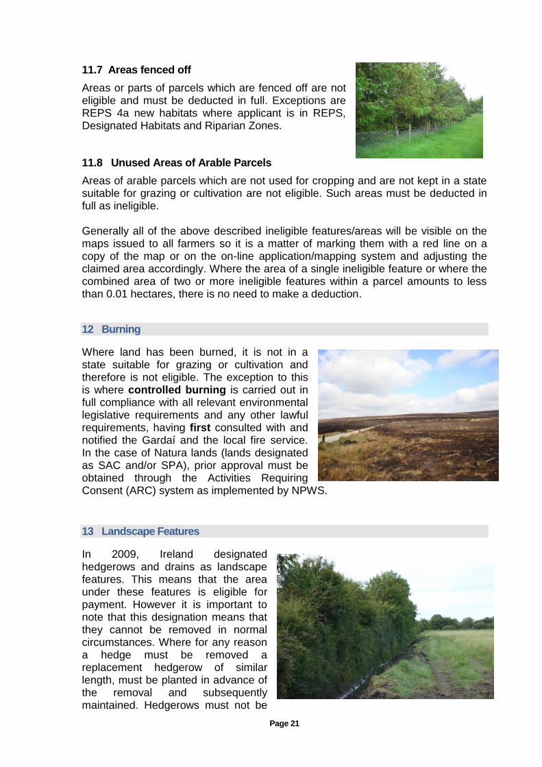
13 Landscape Features
In 2009, Ireland designated hedgerows and drains as landscape features. This means that the area under these features is eligible for payment. However it is important to note that this designation means that they cannot be removed in normal circumstances. Where for any reason a hedge must be removed a replacement hedgerow of similar length, must be planted in advance of the removal and subsequently maintained. Hedgerows must not be

Page 22
removed in the bird nesting season. Hedgerows planted for Agri-Environment Scheme purposes cannot be used to replace landscape features. Farmers must maintain hedgerows regularly to ensure that they do not encroach onto the adjoining farmland otherwise they can no longer be considered eligible for payment and corresponding reductions will have to be made to the declared area until the hedge is returned to its traditional width.
A drain is defined as a man made feature and is eligible. Streams and rivers on the other hand are natural features and deductions must be made to take account of the area involved. Where there is no fence in place to prevent animals from entering drains, they can be damaged very quickly and in extreme cases cross compliance penalties may be applied for failure to maintain them.
Where drains are fenced, as required under environmental schemes such as REPS, GLAS, etc., the area between the drain and the fence continues to be eligible.
Hedgerows and drains must be retained and maintained, and failure to do so will result in cross compliance penalties.
14 Natura 2000 and Water Framework
Directive
Natura 2000 is an EU wide network of protected areas. It is comprised of Special Areas of Conservation (SAC) under the Habitat’s Directive and Special Protection Areas (SPA) under the Bird’s Directive. Certain areas of the country have been designated in order to assure the survival of valuable species and habitats. Designation of these sites requires compliance with certain conditions. All land owners with lands in these sites have been informed of their designation. Notwithstanding this, applicants for direct payment are obliged to ensure they are aware of the particular status of these lands and the conditions applying. This information is available from the National Parks and Wildlife Service (NPWS) at: www.npws.ie
The Water Framework Directive (WFD) imposes requirements on the management of lands in the vicinity of certain water bodies, as implemented by the Department of the Environment, Community and Local Government and the Department of Agriculture, Food and the Marine.
Where further areas have become ineligible and this is due to compliance with SPA or SAC management requirements or ecological objectives or the requirements of the Water Framework Directive, these areas will continue to be eligible for payment provided that:
the newly ineligible area was due to compliance with SPA, SAC or WFD requirements/objectives;
the area in question was declared on a 2008 SPS application form;
the area was declared as eligible to draw down an SPS payment in 2008;
the applicant who declared that land on a 2008 SPS application form was paid under the 2008 Single Payment Scheme.

Page 23
15 Further Examples of Land Eligibility
Ongoing management required to avoid the land becoming ineligible
Eligible - Open mountain area
Page 24
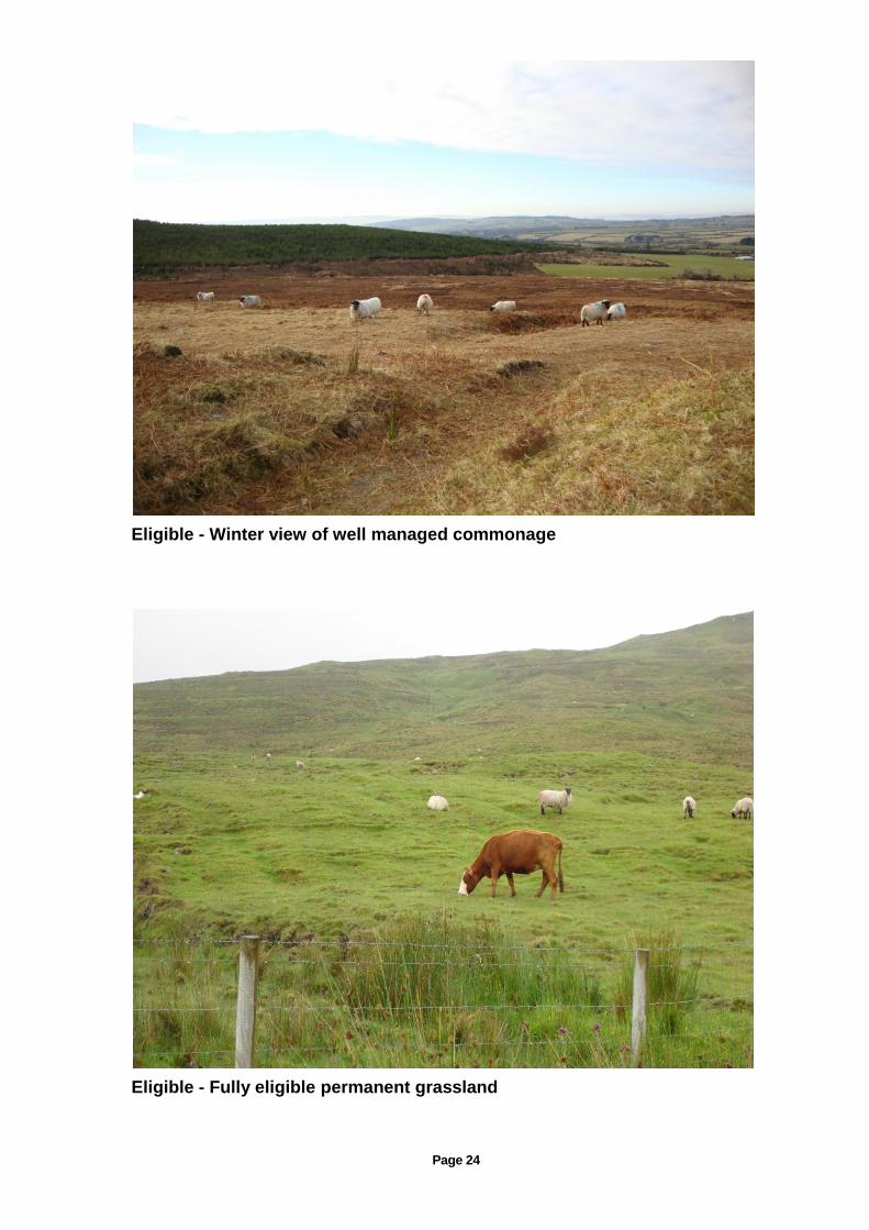
Eligible - Winter view of well managed commonage
Eligible - Fully eligible permanent grassland

Page 25
Eligible Commonage
Ineligible - Marshy area covered in scrub

Page 26
Eligible land
Ineligible bog

Page 27
Parcel requiring percentage reduction to reflect ineligible area
Ineligible - Overgrazed leading to soil erosion
Page 28
16 Environmental Impact Assessment
The Environmental Impact Assessment (Agriculture) Regulation 2011 (EIA) requirements deal with land drainage, field boundary removal, re-contouring of land and the conversion of semi-natural land to intensive agriculture. Before undertaking any of these activities you must comply with the requirements set out in this regulation. Details are available on the Department’s website.
17 Inspections
Under EU regulations, it is necessary to conduct land eligibility inspections on a minimum of 5% of applicants each year. These inspections are conducted using the remote sensing procedure followed by a ground verification check where required, or by a full ground inspection. Further details on inspections are available in the Terms and Conditions booklet.
A full appeal procedure is available to any applicant, who for whatever reason, is not satisfied with the inspection findings.
In addition to the minimum 5% inspection rate, a Member State is obliged to review the eligibility status of all parcels on the LPIS as and when new ortho-photos become available and this may involve ground verifications checks.
18 Farm Advisory Service (FAS)
EU legislation requires Member States to have an advisory system in place to give advice on a range of areas including land eligibility. In Ireland approximately 700 FAS Advisors are currently approved. In order to retain the FAS status each advisor is obliged to undertake routine training on all aspects of the direct payment schemes including the minimum requirements on land eligibility. The service is provided by Teagasc and private consultancy services. A list of such advisors is available on the Department’s website.

Page 29
Annex 1. Implementing Legislation
EU Regulations
REGULATION (EU) No 1305/2013 OF THE EUROPEAN PARLIAMENT AND OF THE COUNCIL of 17 December 2013 on support for rural development by the European Agricultural Fund for Rural Development (EAFRD)-OJ L347 of 20/12/2013 COMMISSION DELEGATED REGULATION (EU) No 807/2014 of 11 March 2014 supplementing Regulation (EU) No 1305/2013 of the European Parliament and of the Council on support for rural development by the European Agricultural Fund for Rural Development and introducing Transitional measures. OJ L227 of 31/7/2014. COMMISSION IMPLEMENTING REGULATION (EU) No 808/2014 of 17 July 2014 laying down rules for the application of Regulation (EU) No 1305/2013 of the European Parliament and of the Council on support for rural development by the European Agricultural Fund for Rural Development (EAFRD) OJ L227 of 31/7/2014. REGULATION (EU) No 1306/2013 OF THE EUROPEAN PARLIAMENT AND OF THE COUNCIL of 17 December 2013 on the financing, management and monitoring of the common agricultural policy. OJ L347 of 20/12/2013 COMMISSION DELEGATED REGULATION (EU) No 640/2014 of 11 March 2014 supplementing Regulation (EU) No 1306/2013 of the European Parliament and of the Council with regard to the integrated administration and control system and conditions for refusal or withdrawal of payments and administrative penalties applicable to direct payments, rural development support and cross compliance. OJ L181 of 20/6/2014. COMMISSION IMPLEMENTING REGULATION (EU) No 809/2014 of 17 July 2014 laying down rules for the application of Regulation (EU) No 1306/2013 of the European Parliament and of the Council with regard to the integrated administration and control system, rural development measures and cross compliance. OJ L227 of 31/7/2014 REGULATION (EU) No 1307/2013 of the European Parliament and of the Council of 17 December 2013 establishing rules for direct payments to farmers under support schemes within the framework of the common agricultural policy. OJ L 347 of 20/12/2013. COMMISSION DELEGATED REGULATION (EU) No 639/2014 of 11 March 2014 supplementing Regulation (EU) No 1307/2013 of the European Parliament and of the Council establishing rules for direct payments to farmers under support schemes within the framework of the common agricultural policy and amending Annex X to that Regulation. OJ L181 of 20/6/2014. COMMISSION IMPLEMENTING REGULATION (EU) No 641/2014 of 16 June 2014 laying down rules for the application of Regulation (EU) No 1307/2013 of the European Parliament and of the Council establishing rules for direct payments to farmers under support schemes within the framework of the common agricultural policy. OJ L181 of 20/6/2014 All EU legislation is available at: http://www.europa.eu


![THE PUNJAB PRIVATE HOUSING SCHEMES AND LAND SUB- … · TEXT PUNJAB PRIVATE HOUSING SCHEMES AND LAND SUB-DIVISION RULES 2010 SOR(LG)38-2/2004-P [13th March, 2010] CHAPTER I INTRODUCTION](https://static.fdocuments.in/doc/165x107/5e7744fd8988d71fb905bacd/the-punjab-private-housing-schemes-and-land-sub-text-punjab-private-housing-schemes.jpg)


