A guide to coastal erosion management practices in … · A guide to coastal erosion management ......
23
Service contract B4-3301/2001/329175/MAR/B3 “Coastal erosion – Evaluation of the needs for action” Directorate General Environment European Commission A guide to coastal erosion management practices in Europe: lessons learned January 2004 Prepared by the National Institute of Coastal and Marine Management of the Netherlands
Transcript of A guide to coastal erosion management practices in … · A guide to coastal erosion management ......

Service contract B4-3301/2001/329175/MAR/B3
“Coastal erosion – Evaluation of the needs for action”
Directorate General Environment
European Commission
A guide to coastal erosion management
practices in Europe: lessons learned
January 2004
Prepared by the
National Institute of Coastal and Marine Management of the Netherlands

2
LESSONS LEARNED FROM THE CASE STUDIES
Lesson 1 Human influence, particularly urbanisation and economic activities, in the coastal zone has turned coastal erosion from a natural phenomenon into a problem of growing intensity. Adverse impacts of coastal erosion most frequently encountered in Europe can be grouped in four categories: (i) coastal flooding as a result of complete dune erosion, (ii) destruction of assets located on retreating cliffs, beaches and dunes (iii) undermining of sea defence associated to foreshore erosion and coastal squeeze, and (iv) loss of lands of economical and ecological values. Coastal erosion is a natural phenomenon, which has always existed and has contributed throughout history to shape European coastal landscapes. Coastal erosion, as well as soil erosion in water catchments, is the main processes which provides terrestrial sediment to the coastal systems including beaches, dunes, reefs, mud flats, and marshes. In turn, coastal systems provide a wide range of functions including absorption of wave energies, nesting and hatching of fauna, protection of fresh water, or siting for recreational activities. However, migration of human population towards the coast, together with its ever growing interference in the coastal zone has also turned coastal erosion into a problem of growing intensity. Among the problems most commonly encountered in Europe are: • the destruction of the dune system as a result of a single storm event, which in turn results
in flooding of the hinterland. This is best illustrated by the cases of Holland Coast, Western Scheldt, Wadden Sea, Rosslare, Hel peninsula, Sylt, Camargue, Vagueira, and Castellon.
• the collapse of properties located on the top of cliffs and dunes as documented in the cases
of South Down, Luccombe, Normandy, Hyllingebjerg – Liseleje, Castellon, Vale do Lobo, and Estela
• the undermining of sea flooding defences as a result of foreshore lowering such as in
Knokke-Zoute, Humber Estuary, Ystad, Chatelaillon, Sable d’Olonne, Donegal, or coastal marsh squeeze such in Elbe and Essex
• the loss of lands with economical value such as the beaches of De Haan, Sylt, Mamaia,
Vecchia Pineta, Giardini Naxos, Sable d’Olonnes, and Ghajn Tuffieha, the farming lands of Essex or with ecological value such as the Scharhoern Island along the Elbe estuary.
To a lesser extent, the decrease of the fresh water lens associated to the retreat in the dune massifs, which in turn result in salt water intrusion could be mentioned but this phenomenon has been only evoked but not fairly documented in the cases reviewed by the project. It is therefore assumed that this particular problem remains marginal in Europe.

Lesson 2 Coastal erosion results from a combination of various factors – both natural and human-induced – which has different time and space patterns and have different nature (continuous or incidental, reversible or non-reversible). In addition, uncertainties still remain about the interactions of the forcing agents, as well as on the significance of non-local causes of erosion. This is highly confirmed by the totality of the cases reviewed. The various coastal types, as was demonstrated in the introduction to the cases, determine the difference in resistence against erosion. While hard rock coasts hardly erode, soft cliffs and sedimentary coast are much less resilient. Subsequently, various natural factors - acting on different time and spatial scales - reshape the geologically formed coastal morphology. Furthermore human-induced factors are present in many cases and they operate on the morphological development of the coastal area as well. In addition, the dominant cause of coastal erosion may stay “hidden” for decades if not centuries before scientist finally evoke it and quantify its amplitude. This often corresponds to causes whose effects are hardly noticeable on the short term but after decades, and causes which are non-local. River damming belongs to this category and evidence of its impact to erosion processes have been lately evoked and in a fewer number of cases, quantified and demonstrated. It is important to mention that this question of erosion induced by river damming is still subject to polemics or contradictory expertise as in the case of Tagus (Cova do Vapor), Douro (Vagueira) (Portugal), Rhone delta (France) or Messologi (Greece). In some other cases, such as Ebro (Spain), dam-induced sediment deficit has been well documented. Figures 1-1 and 1-2 respectively summarise natural factors and human-induced factors responsible for coastal erosion and highlight the time and space patterns within which these factors operate.
Figure 1-1. Time and space patterns of natural factors of coastal erosion Note that “distance” has to be understood as the geographical extent within which the factor action takes place or take
place with a relatively stable intensity. “Time” reflects the temporal extent within which the factor occurs and causes erosion.

4
The natural factors include: Waves. Waves are generated by offshore and near-shore winds, which blow over the sea surface and transfer their energy to the water surface. As they move towards the shore, waves break and the turbulent energy released stirs up and moves the sediments deposited on the seabed. The wave energy is a function of the wave heights and the wave periods. As such the breaking wave is the mechanical cause of coastal erosion in most of cases reviewed and in particular on open straight coasts such as those of Sussex, Ventnor, Aquitaine, Chatelaillon, Holland, Vagueira, Copa do Vapor, Estella, Valle do Lobo, Petite Camargue, Marina di Massa, Giardini Naxos, Ystad, or Rostock. Winds. Winds acts not just as a generator of waves but also as a factor of the landwards move of dunes (Aeolian erosion). This is particularly visible along some sandy coasts of those Aquitaine, Chatelaillon, Rosslare, and Holland. Tides. Tides results in water elevation to the attraction of water masses by the moon and the sun. During high tides, the energy of the breaking waves is released higher on the foreshore or the cliff base (cliff undercutting). Macro-tidal coasts (i.e. coasts along which the tidal range exceeds 4 meters), all along the Atlantic sea (e.g. Vale do Lobo in Portugal), are the more sensitive to tide-induced water elevation than mesa- or micro-tidal coasts (i.e. tidal range below 1 meter). Near-shore currents. Sediments scoured from the seabed are transported away from their original location by currents. In turn the transport of (coarse) sediments defines the boundary of coastal sediment cells, i.e. relatively self-contained system within which (coarse) sediments stay. Currents are generated by the action of tides (ebb and flood currents), waves breaking at an oblique angle with the shore (long-shore currents), and the backwash of waves on the foreshore (rip currents). All these currents contribute to coastal erosion processes in Europe. By way of illustration, long-shore drift (transport) is responsible of removing outstanding volumes of sand in Vale do Lobo, Estela beach, Aquitaine, De Haan, Zeebrugge, Sylt or Jutland. Erosion induced by cross-shore sediment transport is best illustrated with the cases of Sable d’Olonne or Donegal. As for tidal currents, their impact on sediment transport is maximal at the inlets of tidal basins or within estuaries such as in the cases of the Wadden Sea, the Arcachon basin, the Western Scheldt and the Essex estuaries. In some places, near-shore currents, and associated sediment cells, follow complex pathways as epitomised by the cases of Estela or Rosslare, or Falsterbo. Storms. Storms result from raised water levels (known as storm surge) and highly energetic waves induced by extreme winds. Combined with high tides, storms may result in catastrophic damages such as along the North Sea in 1953. Beside damages to coastal infrastructure, storms cause beaches and dunes to retreat of tenths of meters in a few hours, or may considerably undermine cliff stability. In the past 30 years, a significant number of cases have reported extreme historical storm events that severely damaged the coast. Illustrative examples include De Haan and Holland (storm of 1976), Chatelaillon (1962, 1972, 1999), Cova do Vapo and Estela (2000), Normandy (1978, 1984, 1988, 1990), and Donegal (1999). Sea level rise. The profile of sedimentary coasts can be modelled as a parabolic function of the sediment size, the sea level, the wave heights and periods, and the tidal range. When the sea level rises, the whole parabola has to rise with it, which means that extra sand is needed to build up the profile. This sand is taken from the coast (Bruun rule). Though more severe in sheltered muddy areas (e.g. Essex estuaries), this phenomenon has been reported as a significant factor of coastal erosion in all regional seas: Atlantic Sea (e.g. Donegal, Rosslare),

Mediterranean Sea (e.g. Petite Camargue, Messologi, Lakkopetra), North Sea (e.g. Holland coast), Baltic Sea (e.g. Gulf of Riga), and Black Sea. Slope processes. The term “slope processes” encompasses a wide range of land-sea interactions which eventually result in the collapse, slippage, or topple of coastal cliff blocks. These processes involve on the one hand terrestrial processes such as rainfall and water seepage and soil weathering (including alternating freeze/thaw periods), and on the other hand the undercutting of cliff base by waves. The cases of Luccombe, Birling Gap, Criel-sur-Mer (Normandy), Sylt, Cova do Vapor, Vale do Lobo are particularly relevant in that respect. Vertical land movements. Vertical land movement – including isostatic rebound, tectonic movement, or sediment settlement – may have either a positive of negative impact on coastline evolution. If most of northern Europe has benefited in the past from a land uplift (e.g. Baltic sea, Ireland, Northern UK), this trend has stopped (with exception of the coast of Finland), such as in Donegal and Rosslare, and even reversed (e.g. Humber estuary). Along these coasts, the sea level induced by climate change rises faster than the sea, which results in a positive relative sea level rise. Human induced factors Coastal artificialisation including hard coastal defence. Coastal artificialisation may be defined as the engineering of the waterfront by way of seawalls, dykes, breakwaters, jetties, or any hard and rock-armoured structures, which aims at protecting the construction or other assets landwards the coastline from the assault of the sea. Such structures modify coastal sediment transport patterns through 3 major processes:
(i) trapping of sediment transported alongshore and a sediment deficit downdrift due to the fact that contrary to “natural” coastlines, hard structures do not provide sediment for the alongshore drift. Mainly by harbour and marina protection structures such as those of Brighton - Sussex (United Kingdom), Aveiro - Vagueira case and Vilamora - Vale do Lobo (Portugal), Rosslare (Ireland), IJmuiden - Holland case (Netherlands), Zeebrugge (Belgium), Skanor – Falsterbo (Sweden), Messina (Italy) or by groines such as those of Ystad (Sweden), Jutland (Denmark), Quarteira - Vale do Lobo, Vagueira, Estela (Portugal), Marina di Massa (Italy), and Hel Peninsula (Poland).
(ii) Incoming wave reflection by hard structures that hampers energy dissipation and
augments turbulence resulting in increased cross-shore erosion. This phenomenon has been paradoxically boosted along those coastal stretches where seawalls have been built precisely to counteract coastal erosion, and is best illustrated by the cases of Chatelaillon and Sable d’Olonne (France).
(iii) Wave diffraction, which is the alteration of the wave crest direction due to the
vicinity of seaward structures (such as jetties or breakwaters). This alteration results in wave energy to be either diluted in some places (less impact on the coastline) or concentrated in some other places (more impact on the coastline and subsequent erosion). Note that in the case of Playa Gross (spain), wave diffraction induced by a semicircular breakwater is on the contrary used as part of the coastal erosion management solution.

6
Figure 1-2. time and space patterns of human induced factors of coastal erosion.
Land reclamation. The impact of land reclamation projects undertaken in the 19th and first half of the 20th century on coastal erosion has become obvious only for a few decades. Within tidal basins or bays (where land reclamation projects are most easy to undertake), land reclamation results in a reduction of the tidal volume and therefore a change in the ebb and flood currents transporting sediments. As a result, relatively stable coastal stretches may begin to erode. Land reclamation projects undertaken in Rosslare (Ireland) (in 1845 and 1855) or the Western Scheldt (Netherlands) provide quite illustrative example of this phenomenon. For land reclamation projects undertaken along open coasts, such as the Maasvlakte project along the Holland coast (Netherlands), changes in coastal processes do not occur as a result of tidal volume reduction but as a result of changes in the coastline geometry and breaking angles. River water regulation works. Such as for land reclamation, the impact of water flow regulation works on coastal processes has been highlighted only recently probably such impacts become visible after several decades. Damming has intensively sealed water catchments locking up millions of cubic metres of sediments per year. For some southern European rivers (e.g. Ebro, Douro, Urumea, Rhone), the annual volume of sediment discharge represents less than 10% of their level of 1950 (less than 5% for the Ebro) resulting in a considerable sediment deficit at the river mouth, and subsequent erosion in the sediment cell as illustrated by the cases of Ebro delta, Playa Gross (Spain), Petite Camargue - Rhone delta (France) and Vagueira (Portugal). Besides river damming, any activity which result in reducing the water flow or prevent river flooding (as a major generator of sediments in the water system) is expected to reduce the volume of sediments reaching the coast. This is best illustrated by the case of the Tagus which impact can still be felt at Cova do Vapor (Portugal). Dredging. Dredging activities have intensified in the past 20 years for navigational purposes (the need to keep the shipping routes at an appropriate water depth), construction purposes (an increasing amount of construction aggregates comes from the seabed), and since the 1990’s for beach and underwater nourishment. Dredging may affect coastal processes by a variety of way:

(i) by removing from the foreshore materials (stones, pebbles), which protect the coast against erosion. For instance, stone fishing in Hyllingebjerg-Liseleje (Denmark) triggered structural erosion. By way of illustration, it is estimated that 50% of the total volume of the protective pebbles (3 millions cubic meters) has been extracted from the chalk cliff of Normandy (France) since the early 1900’s.
(ii) by contributing to the sediment deficit in the coastal sediment cell, such as in the
Humber estuary, the coast of Sussex (United Kingdom) for construction purpose (extraction of sand, gravel and shingle), the Western Scheldt (Netherlands) for navigational purposes, Cova do Vapor (Portugal) where sand has been dredged off the coast to supply materials for the beaches of Costa del Sol, or Marinell di Sarzana and Marina di Ravenna – Lido Adriano (Italy) where dredging from river beds took place
(iii) By modifying the water depth, which in turn result in wave refraction and change of
alongshore drift, as illustrated by the Wadden Sea (Netherlands). Vegetation clearing. A significant number of cases have highlighted the positive role of vegetation to increase the resistance to erosion - e.g. Aquitaine (France) and the Baltic States: Gulf of Riga (Latvia), Klaipeda (Lithuania), Tallinn (Estonia). With the same idea, changes of land use and land cover patterns, which tend to reduce the vegetation cover on the top of cliffs may increase infiltration of water and undermine the cliff stability. This is best illustrated by the examples of the golf courses of Estela and Vale do Lobo (Portugal). Gas mining or water extraction. A few examples illustrate the effect of gas mining or water extraction on land subsidence (Wadden Sea - Netherlands). Altough this phenomenon seems to have a limited geographical scope in Europe, its effects are irreversible and can be quite significant. In Marina di Ravenna – Lido Adriano (Italy) the land subsides nearly a meter over last 50 years, causing a major sediment deficit and a strong retreat of the coastline. Ship-induced waves. This case is evoked in the case study related to the Gulf of Riga (Latvia).
Lesson 3 Coastal erosion induced by human activities have surpassed in Europe coastal erosion driven by natural factors. Human-induced coastal erosion mainly proceeds from the cumulative and indirect impacts of small and medium size projects, as well as from river damming. However, little attention is being paid to these impacts by project developers, Environmental Impact Assessment (EIA) practitioners and competent authorities. With the exception of harbour authorities, geo-morphological changes along the coast are not being paid the attention they should deserve by the promoters of projects impacting coastal processes. The poor number of Environmental Impact Assessment (EIA) reports that address coastal sediment processes as a serious environmental impact largely reflects this. It has to be mentioned however that EIA reports are still very difficult to obtain even after the administrative authorities in charge of project consent have approved them. The opinion expressed here is therefore mainly based on EIA reports which could be only be retrieved a few number of case studies reviewed by EUROSION, as well as on discussions with some members of EUROSION
8
Advisory Board. EIA reports retrieved concerned the Maasvlakte extension (Holland coast - Netherlands), the annual dredging programmes of the Western Scheldt estuary (Netherlands), the Aveiro harbour extension (Aveiro - Portugal), the energy production plant of Penly (Normandy - France), the German offshore wind farms located east of the Wadden Sea, and the seafront rehabilitation scheme of Marina di Massa and Marina di Pisa (Tuscany - Italy). The relatively poor integration of coastal sediment transport and induced morphological changes in EIA procedures may be explained by the fact that, except in the case of major projects such as the extension of big harbours, coastal erosion cannot be attributed directly to one single coastal development project (see lesson 2). Impact of small and medium size projects are instead cumulative with the impact of other developments, which tends to dilute the responsibility of each individual project for coastal erosion. This is confirmed by the few number of small and medium-size projects along the coast, which are required to conduct an EIA by the competent authorities during the “screening” phase (less than 10% of the total number of projects along the Holland coast). Even in those cases where an EIA is required, impact on coastal sediment processes may not be retained during the “scoping” phase as part of the environmental concerns to be covered by the EIA. Table 1 provides a brief overview of how coastal erosion coverage is currently taken into consideration by various types of developments. Table 1-1. Coastal erosion within EIA procedures Type of projects Impact on coastal erosion Covered by EIA? Harbour infrastructure and activities (including navigational dredging)
High Yes
River water regulation works (mainly dams)
High No
Seafront construction
Moderate No
Land reclamation near-shore or offshore (e.g. wind farm)
Moderate Partially
Aggregate extraction (dredging) for construction and nourishment purposes
Moderate Yes
Gas mining (relative sea level rise induced by land subsidence)
Low to moderate No
Maritime navigation (ship -induced waves)
Low No
The lack of consideration for coastal sediment transport processes in EIA procedures is undeniably emphasised by the poor level of sensitisation of project developers and EIA practitioners. Denial or underestimation of the impacts of human interference in the coastal zone, which possibly intensify the coastal erosion problems, results in a less effective approach. A number of EUROSION advisory board members have recommended that existing EIA guidelines edited by the European Commission – and more specifically those dealing with indirect and cumulative impact assessments – provide a higher visibility and a practical understanding of coastal sediment transport processes.

Lesson 4 Knowledge on the forcing agents of coastal erosion and their interaction tends to increase over time. However, this knowledge is fragmented and empirical as reflected by the many models commonly used throughout Europe to anticipate coastal morphological changes. Since the 1950’s, major efforts have been undertaken to understand the behaviour of coastal systems and highlight the interactions between waves, wind, tides, foreshore profile, sediment transport and finally coastline evolution. These efforts have led to the development of models, which are now commonly used in coastal engineering design. Annex 1 provides an overview of models of coastal processes applied in the framework of cases studies reviewed by EUROSION or mentioned in their associated bibliography. This overview clearly shows that the understanding of coastal processes is still largely fragmented and empirical. As a result of this fragmentation, different theories building upon different concepts, assumptions and approaches have been developed since the 1950’s and have resulted in different models more or less compatible. This multiplicity of models can be explained by the complexity of the phenomena involved in coastal morphological changes and their interactions, which remain largely unexplained. Because of their relevance for coastal erosion management, a particular attention was paid during the review to models simulating:
• elevation of water level induced by wind stress • near-shore wave transformation including shoaling, refraction, reflection, diffraction • response of dune profile to storms • response of beach profile to sea level rise • wave-foreshore interactions including wave breaking, run-up and overtopping • sediment transport including alongshore and cross-shore transport of sand, mud and
sand/mud mixture The agents forcing the above mentioned phenomena – coastline geometry, wave heights and periods, wind speed and direction, astronomic tides, currents velocity, water depth, sea bottom roughness, bathymetry, foreshore profile and sediment size – are common to a majority of models, but the way these agents are combined varies from one model to another. In practice, a significant number of simple empirical and semi-empirical models (e.g. the Bruun rule or the CERC equation) are being developed with acceptable results for a limited number of situations (e.g. for open straight coasts, mild slope shoreline, estuaries, negligible diffraction and reflection phenomenon, etc.); the same models present however major limitations which make their use to other situations unacceptable. On the other side, robust theories such as the Bijker transport theory (1971) exist and cover a wider range of situations but require considerable fields measurements and computation resources. The operational consequence of this broad range of models is that coastal engineers never really know in advance which model will fit into their specific situation. In general further improvements are needed to existing models in order to really stick to the conditions prevailing in a specific case studies. This is the case for example with the ESTMORF model specifically developed for simulating morphological changes in the Western Scheldt estuary (Netherlands). Lessons learnt from the case studies reviewed within EUROSION also shows that replicability of existing models may be hazardous, since the coastline response to engineered mitigation solutions may not be conform to model predictions. This is epitomised by the case of Rosslare (Ireland) where the coastline unexpectedly responded to a massive beach nourishment scheme

10
via the formation of an offshore sand bar, or the case of Playa Gross (Spain) where the observed beach response to the wave and tide regime overrides model predictions under certain weather conditions.
Lesson 5 Past measures to manage coastal erosion have generally been designed from a local perspective: they have ignored the influence of non-local forcing agents and have disregarded the sediment transport processes within the larger coastal system. As a consequence, they have locally aggravated coastal erosion problems, and have triggered new erosion problems in other places. They still influence the design of present measures. Historically, many hard constructions were built to stop local erosion in order to protect the assets at risk. Although an effective solution on the short term, their longer-term effectiveness was mostly unsatisfactory. In front of many seawalls, boulevards and revetments, the beach eroded as a result of wave reflection. This destabilized the constructions. Maintenance appeared to be costly and some of the constructions proved to be unequal to the powerful natural processes and broke down. This urged costly reconstructions or the building of new (additional) constructions. In other cases the building of groins and breakwaters resulted in a shift of the erosion to neighbouring areas and urged the need for further protection of the assets at risk. This resulted in a domino effect of hard constructions, for example in Hel Peninsula (Poland) where in time a complete groin field was created over a distance of 12 km. In many cases the groins did not prevent erosion on the long run. Nowadays, some coastal defence structures inherited from past management strategies are still “active” as the seawalls of Playa Gross (Spain, built in 1900), Chatelaillon (France, 1925), De Haan (Belgium, 1930), or the vegetated dunes of Western Jutland (Denmark) stabilized in the 1900’s, and they keep on interacting – positively or negatively - with sediment processes. The traditional local perspective of coastal erosion management is illustrated by the poor number of Environmental Impact Assessment (EIA) reports that address coastal sediment processes as a serious environmental impact (lesson 3). An exception to the picture described above can be found in some of the cases. A nice example is Marinella di Sarzana (Italy), where neighbouring communities successfully cooperated on a combined river and coastal zone management, resulting in an integrated project proposal, which is evaluated through the Environmental Impact Assessment procedures.
Lesson 6 As an attempt to better respond locally to non-local causes of coastal erosion and to anticipate the impact of erosion management measures, a number of cases mainly in Northern Europe have built their coastal erosion management strategies upon the concept of “sediment cell” as well as on a better understanding of sediment transport patterns within this sediment cell. Such approaches require a strong cooperation between regions which share a same sediment cell.
In understanding the causes and extent of coastal erosion, the introduction of the concept of the “coastal sediment cell” undeniably constitutes a major breakthrough, as it helps to delimit the geographical boundaries of investigations for erosion causes and impact of erosion mitigation measures (e.g. Normandy, Vagueira, Essex, Isle of Wight, Holland coast, Wadden sea). A coastal sediment cell can be defined as a length of coastline and associated near-shore areas where movement of sediments is largely self contained. In practice, this means that measures taken within a specific sediment cell may have an impact of other sections of the same sediment cell but will not impact adjacent cells. From the “coastal sediment cell” perspective, a loss of sediment is less favourable than redistribution within the coastal system. Less sediment within the system restricts the ability of the coastline to adapt to changing circumstances. Furthermore, hard constructions like harbour-moles or breakwaters block (some part of) the natural sediment transport. Some amount of sediment is “imprisoned” by the constructions and is not freely available in the natural process. The same effects occur when stabilizing cliffs (eg. Sussex) , preventing the natural input of sediments from cliff erosion. Therefore, fixing of sediments (due to hard constructions) is less favourable than using measures that disturb the natural processes to a lesser extent or measures which even make use of the natural processes, for example beach- and foreshore nourishments. The latter choice is called “working with nature”. Building upon the concept of coastal sediment cell therefore lead to adopt the following three key management principles for the coastline which have been verified in the cases of Normandy, Sussex, Isle of Wight, Essex, Holland Coast, and Wadden sea:
1. Maintain the total amount of sediment (in motion or dormant) within the coastal system 2. When taking measures, try to work with natural processes or leave natural processes
as undisturbed as possible 3. If no other options available, use hard constructions to keep sediments in its position
The concept of sediment cells presents however major limitations due to its time dependence: sediment processes within a specific sediment cell cannot be totally “self contained” and transfer of sediments among adjacent cells may finally become non negligible after a long period. Moreover, the concept of sediment cell is restricted to processes occurring along the shoreline and do not include land-based causes of coastal erosion such as reduction of river sediments or modification of river outflows and estuary water levels as observed in the Gulf of Riga. These limitations have led some cases, such as Essex, to request a fine-tuning of the sediment cell concept.
Lesson 7 Experience has shown that, at the present time, there is no miracle solution to counteract the adverse effects of coastal erosion. Best results have been achieved by combining different types of coastal defence including hard and soft solutions, taking advantage of their respective benefits though mitigating their respective drawbacks. From the observation that coastal erosion results from a combination of various natural and human-induced factors (lesson 2) it is not surprising that miracle solutions to counteract the adverse effects don’t exist. Nevertheless, the general principle of “working with nature” was proposed as a starting point in the search for a cost-effective measure (lesson 6).

12
However, this observation also undeniably takes in flank the idea that soft engineering solutions are preferable to hard ones. This is backed by a number of considerations derived from experience: • Even well tried soft solutions - such as beach nourishment, which arouses a tremendous
enthusiasm in the past 10 years - have been subject to serious setbacks. Such setbacks have been caused by inappropriate nourishment scheme design induced by poor understanding of sediment processes (technical setback), difficult access to sand reserves which induces higher costs (financial setback)), or unexpected adverse effects on the natural system and principally the benthic fauna (environmental setback). These are respectively well covered by the case of Vale do Lobo (Portugal) where 700,000 cubic metres and 3,2 millions Euros of investment have been washed away by long-shore drift within a few weeks only, the case of Ebro where the sediment volume needed to recharge the beach of sediments had been imported from another region, and the case of Sitges (Spain) where dredging of sand to be supplied causes irreversible damage to sea grass communities (Posidonia).
• Soft solutions, due to their particularity of working with nature, are found to be effective
solutions only in a medium to long-term perspective, i.e. when coastal erosion does not constitute a risk in a short-term perspective (5 to 10 years). Their impact indeed slows down coastline retreat but do not stop it. When it does, the long term positive effect of soft solutions may be optimised by hard structures which make it possible to tackle an erosion problem efficiently but have a limited lifetime (side in general no more than 10 years). This has been particularly well documented in the cases of Petite Camargue (France) where presence of hard structures - condemned anyway – also turned out to provide sufficient visibility for soft defence such as dune restoration wind-screens to operate, the case De Haan (Belgium), where a seawall provide safety to social and economical assets though beach nourishment with a sub-tidal feeder berm provides long term stability to the surrounding dunes, and the case of Western Jutland (Denmark) where the use of detached breakwaters reduce by a factor expenses related to beach nourishments. In addition, most of the cases of United Kingdom which already benefit from Shoreline management plans (SMP) combines different types of techniques.
Annex 2 summarizes the major pros and cons associated to each individual coastal erosion management technique.
Lesson 8 Assignment of clear and measurable objectives to coastal erosion management solutions - expressed for example in terms of accepted level of risk, tolerated loss of land, or beach/dune carrying capacity - optimises their long-term cost-effectiveness and their social acceptability. This has been facilitated by the decrease of costs related to monitoring tools. In most of the case studies reviewed, coastline retreat is a phenomenon observed for more than a hundred years. In a few cases, such as the Isle of Wight (United Kingdom), evidence exist that men have struggled against coastline retreat for thousands of years. In addition and though they get older, some coastal defence structures inherited from past management strategies are still “active” and they keep on interacting – positively or negatively - with sediment processes, as illustrated in lesson 5. In other cases, hard and soft solutions implemented had a lifetime that

did not exceed a few months, such as the timber groins of Rosslare (Ireland) or Chatelaillon (France) – or even a few weeks such as the beach nourishment schemes of Vale do Lobo (Portugal). This highlights the needs for adequate monitoring of solutions all through the lifespan of coastal erosion management solutions since these solutions may not reach the efficiency targeted, or on the contrary, may continue to interact with other elements even beyond their initially planned life span. Experiences from case studies also revealed that coastal erosion management solutions which have defined beforehand clear objectives and implemented regular monitoring programmes could also detect quicker any discrepancy between the expected coastline response and effective coastline response. They are also in a position to decide corrective actions which turn to save a significant amount of money at the long run as illustrated by the cases of Western coast of Jutland (Denmark), South Downs (United Kingdom) and Playa Gross (Spain). It is however important to notice that regular monitoring programmes are still an exception in Europe and are not the general rule. There is in particular a significant gap between northern and southern Europe in the systematic use of coastline monitoring techniques as part and parcel of shoreline management policies. Such countries as UK, Netherlands and German Landers have generalized the regular use of LIDAR or ship borne surveys or locally apply ARGUS video systems, though other countries as Portugal, Greece, or even France implement coastline monitoring techniques only punctually and generally as experimental research projects. Annex 3 summarizes the different coastline monitoring techniques used in the case studies reviewed by EUROSION or mentioned in their bibliography. These different coastline monitoring techniques have different resolutions and accuracy and some may offer more opportunities than the others. This is concretely reflected in the average unit cost related to each monitoring technique. Table 2 briefly presents the range of costs associated to various techniques. Information provided in this table assumes that the area to be monitored is larger than 100 km2 to enable significant economies of scale. Economy of scale is indeed an important factor to be taken into consideration as it makes it possible to reduce cost of possibly more than 50% of their initial value, as illustrated by the case of Holland Coast using LIDAR as a routine monitoring technique. Table 1-2. Unit costs of a some coastline monitoring techniques (for areas superior to 100 km2) Monitoring technique Resolution Unit costs in Euros/ km2 Satellite images - SPOT 5 - IKONOS
2,5– 5 meters 1 meter
5-8 10-13
Fixed remote sensing - ARGUS video system
1 meter
20-30
Ground surveying - Beach profiling using total stations or GPS
0,1 meter
100-200
Ship borne echo sounding - Multibeam sonar
0,1 meter
150-250
Aerial photogrammetry
0,1 meter
300-400
Airborne laser altimetry - LIDAR
0,1 meter
500-700

14
Lesson 9
Multi-functional technical designs, i.e. which fulfills social and economical functions in addition to coastal protection, are more easily accepted by local population and more viable economically. The perception of risk by local populations influences considerably the design of coastal defence solutions. A commonly spread idea among communities residing within areas at risk is that hard engineering provides better protection against coastal erosion and associated risk of coastal flooding. This belief, which may be founded at the short-but term but not necessarily at the long run, has been observed in a number of European provinces, such as the Dutch province of Zeeland durably marked by the coastal flooding of 1953. In this province, any attempt to retrocede polders to the sea by cutting dykes has resulted in the past in a storm of protest and finally withdrawal of projects as illustrated by the Western Scheldt compensation plan (1999). Designed both to compensate the loss of lands induced by dredging and increase the tidal volume of the estuary as a response to sea level rise (and therefore increase safety), this plan was withdrawn in 1999 due to strong opposition from local citizens. For similar reasons, it is only recently that sand nourishment schemes, which constitute since 1992 the backbone of the Dutch policy of coastal defence along the Holland coast, have been receiving a large support from local population. This support is largely due to the positive side effects of sand nourishment on recreational activities associated with beach extension, and protection of fresh water lens induced by consolidation of dunes. This is also largely confirmed by a majority of sites throughout Europe which opted for beach nourishment – such as Giardini Naxos, Marina di Massa, Vecchia Pineta (Italy), Can Picafort, Mar Menor (Spain), Mamaia (Romania), De Haan, Zeebrugge (Belgium), Sylt (Germany), Hyllingebjerg (Denmark), Hel Peninsula (Poland), Chatelaillon (France), or Vale do Lobo (Portugal). In some Mediterranean cases, tourism opportunities induced by beach nourishment has become a local stake even if those areas which do not particular suffer from coastal erosion, which in some cases led to illegally mined sand, such as in the case Dolos Kiti (Greece). Beyond beach nourishment scheme whose implementation has been boosted in the past 5 years – unsuccessfully in some cases (see lesson no. 7) - other technical designs have made it possible to combine coastal defence with other social, economical, and ecological functions. This is best illustrated by the examples of the natural area of Koge Bay (Denmark), reclaimed from the sea for nature, recreation and defence (against coastal flooding) purposes, and Sea Palling where artificial reefs have been experimented both to absorb incoming wave energy and regenerate a marine biota. Seeking multi-functional design is also driven by financial considerations. A number of examples exhibit significant costs of coastal defence. They range from a few thousands euros for localised protection through wooden pile breakwaters or geotextiles – such as along Estela beach (Portugal, 20,000 Euros) – to several of millions euros – for complete reshaping of the beach by combination of sand nourishment, rock armoured breakwaters, and design studies - such in Playa Gross (Spain, 11 millions Euros). To these costs must be added maintenance and monitoring cost and, in the case of beach nourishment, the cost for repeating nourishment actions regularly. Technical designs fulfilling different functions therefore increase the chance to find co-funding partners on the long term.

Lesson 10
Though critical for decision-making, the balance of coastal defence costs and their associated benefits is - in general - poorly addressed in Europe. This may lead to expenses, which are at the long run unacceptable for the society compared to the benefits. If the costs of coastal defence and their breakdown by funding partners are rather well reported in most of the cases reviewed, only few of them have documented its benefits appropriately. Among those, the case of South Downs (United Kingdom) estimates that the 14 millions Euros of coastal defence at Shoreham and Lancing provide protection to 135 millions Euros of properties – including 1300 homes and 90 commercial premises – from the risk of coastal erosion and associated flooding within 100 years. Along the North Norfolk (United Kingdom) coastal cliffs, the example of Happisburgh demonstrates on the contrary that the costs of cliff stabilization combined with detached breakwaters estimated to several millions of Euros – as proposed by the local authorities - largely exceed the value of the 18 houses buildings and the road, which makes the project not easily bankable. Such assessments of cost and benefits tend to be systematically undertaken in the United Kingdom in so far as the shoreline management plans recommended by DEFRA give the impetus for it. This remains however an exception in other countries in spite of considerable expenses for coastal defence as illustrated by the Dutch coast where an average of 30 to 40 millions Euros are dedicated to beach- and foreshore nourishment each year, the case of Saintes-Marie de la Mer (Petite Camargue - France) where more than 60 millions Euros have been spent over the past 10 years for groins and dune regeneration, or the case of Portugal where 500 millions have been invested in dune and seafront rehabilitation and hard defence since 1995 along coastal stretch lying from the harbour of Aveiro to the resort of Vagueira. It cannot be denied however that local decisions are made on the basis of at least qualitative information on the benefits. Such a qualitative assessment of benefits are briefly reviewed in a number of cases:
• Safety of people and goods – mainly houses – addressed in all cases • Reduction of extreme water levels thanks to sedimentation in the bed of estuaries and
tidal basins (Holderness, Humber, Essex, Wadden Sea) • Better access to harbour facilities by dredging nourishment materials in navigational
channels (Western Scheldt) • Protection of fresh lens against salt water intrusion in fertile hinterlands (Aveiro,
Holland) • Revalorisation of the property market value induced by risk reduction (Playa Gross) • Increase in beach frequentation induced by the foreshore extension (Sitges, Marina di
Massa, Giadini Naxos, Vecchia Pineta), dry sand (Sable d’Olonne), or modification of plunging characteristics of breaking waves (Playa Gross)
• Rehabilitation of natural areas and associated biodiversity (Aquitaine, Koge Bay) • Provision of shelters for fishermen’s boats (Vagueira, Dolos Kiti, Shabla Krapetz) • Absorption of nitrogen’s by coastal marshes initially designed for coastal defence

16
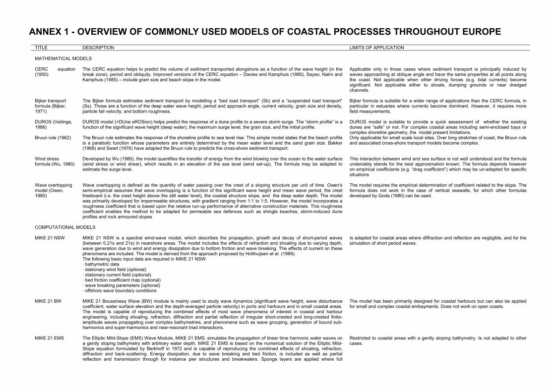
ANNEX 1 - OVERVIEW OF COMMONLY USED MODELS OF COASTAL PROCESSES THROUGHOUT EUROPE
TITLE DESCRIPTION LIMITS OF APPLICATION MATHEMATICAL MODELS
CERC equation (1950)
The CERC equation helps to predict the volume of sediment transported alongshore as a function of the wave height (in the break zone), period and obliquity. Improved versions of the CERC equation – Davies and Kamphuis (1985), Sayao, Nairn and Kamphuis (1985) – include grain size and beach slope in the model.
Applicable only in those cases where sediment transport is principally induced by waves approaching at oblique angle and have the same properties at all points along the coast. Not applicable when other driving forces (e.g. tidal currents) become significant. Not applicable either to shoals, dumping grounds or near dredged channels.
Bijker transport formula (Bijker, 1971)
The Bijker formula estimates sediment transport by modelling a “bed load transport” (Sb) and a “suspended load transport” (Ss). Those are a function of the deep water wave height, period and approach angle, current velocity, grain size and density, particle fall velocity, and bottom roughness.
Bijker formula is suitable for a wider range of applications than the CERC formula, in particular in estuaries where currents become dominant. However, it requires more field measurements.
DUROS (Veilinga, 1986)
DUROS model (=DUne eROSion) helps predict the response of a dune profile to a severe storm surge. The “storm profile” is a function of the significant wave height (deep water), the maximum surge level, the grain size, and the initial profile.
DUROS model is suitable to provide a quick assessment of whether the existing dunes are “safe” or not. For complex coastal areas including semi-enclosed bays or complex shoreline geometry, the model present limitations.
Bruun rule (1962) The Bruun rule estimates the response of the shoreline profile to sea level rise. This simple model states that the beach profile is a parabolic function whose parameters are entirely determined by the mean water level and the sand grain size. Bakker (1968) and Swart (1976) have adapted the Bruun rule to predicts the cross-shore sediment transport.
Only applicable for small scale local sites. Over long stretches of coast, the Bruun rule and associated cross-shore transport models become complex.
Wind stress formula (Wu, 1980)
Developed by Wu (1980), the model quantifies the transfer of energy from the wind blowing over the ocean to the water surface (wind stress or wind shear), which results in an elevation of the sea level (wind set-up). The formula may be adapted to estimate the surge level.
This interaction between wind and sea surface is not well understood and the formula undeniably stands for the best approximation known. The formula depends however on empirical coefficients (e.g. “drag coefficient”) which may be un-adapted for specific situations
Wave overtopping model (Owen, 1980)
Wave overtopping is defined as the quantity of water passing over the crest of a sloping structure per unit of time. Owen's semi-empirical assumes that wave overtopping is a function of the significant wave height and mean wave period, the crest freeboard (i.e. the crest height above the still water level), the coastal structure slope, and the deep water depth. The model was primarily developed for impermeable structures, with gradient ranging from 1:1 to 1:5. However, the model incorporates a roughness coefficient that is based upon the relative run-up performance of alternative construction materials. This roughness coefficient enables the method to be adapted for permeable sea defences such as shingle beaches, storm-induced dune profiles and rock armoured slopes
The model requires the empirical determination of coefficient related to the slope. The formula does not work in the case of vertical seawalls, for which other formulas developed by Goda (1980) can be used.
COMPUTATIONAL MODELS
MIKE 21 NSW MIKE 21 NSW is a spectral wind-wave model, which describes the propagation, growth and decay of short-period waves (between 0.21s and 21s) in nearshore areas. The model includes the effects of refraction and shoaling due to varying depth, wave generation due to wind and energy dissipation due to bottom friction and wave breaking. The effects of current on these phenomena are included. The model is derived from the approach proposed by Holthuijsen et al. (1989). The following basic input data are required in MIKE 21 NSW: · bathymetric data · stationary wind field (optional) · stationary current field (optional) · bed friction coefficient map (optional) · wave breaking parameters (optional) · offshore wave boundary conditions
Is adapted for coastal areas where diffraction and reflection are negligible, and for the simulation of short period waves.
MIKE 21 BW MIKE 21 Boussinesq Wave (BW) module is mainly used to study wave dynamics (significant wave height, wave disturbance coefficient, water surface elevation and the depth-averaged particle velocity) in ports and harbours and in small coastal areas. The model is capable of reproducing the combined effects of most wave phenomena of interest in coastal and harbour engineering, including shoaling, refraction, diffraction and partial reflection of irregular short-crested and long-crested finite-amplitude waves propagating over complex bathymetries, and phenomena such as wave grouping, generation of bound sub-harmonics and super-harmonics and near-resonant triad interactions.
The model has been primarily designed for coastal harbours but can also be applied for small and complex coastal embayments. Does not work on open coasts.
MIKE 21 EMS The Elliptic Mild-Slope (EMS) Wave Module, MIKE 21 EMS, simulates the propagation of linear time harmonic water waves on a gently sloping bathymetry with arbitrary water depth. MIKE 21 EMS is based on the numerical solution of the Elliptic Mild-Slope equation formulated by Berkhoff in 1972 and is capable of reproducing the combined effects of shoaling, refraction, diffraction and back-scattering. Energy dissipation, due to wave breaking and bed friction, is included as well as partial reflection and transmission through for instance pier structures and breakwaters. Sponge layers are applied where full
Restricted to coastal areas with a gently sloping bathymetry. Is not adapted to other cases.

18
TITLE DESCRIPTION LIMITS OF APPLICATION
absorption of wave energy is required. In addition, the model includes a general formulation of radiation stresses, based on Copeland (1985) which is valid in crossing wave trains and in areas of strong diffraction.
MIKE 21 PMS MIKE 21 PMS is based on a parabolic approximation to the elliptic mild-slope equation governing the refraction, shoaling, diffraction and reflection of linear water waves propagating on gently sloping bathymetry. The parabolic approximation is obtained by assuming a principal wave direction (x-direction), neglecting diffraction along this direction and neglecting backscatter. In addition, improvements to the resulting equation, cf Kirby (1986), allow the use of the parabolic approximation for waves propagating at large angles to the assumed principal direction. Furthermore, MIKE 21 PMS can produce the wave radiation stresses required for the simulation of wave-induced currents, which is very important in the computation of coastal sediment transport.
Adapted to open coastal areas with a gently sloping bathymetry and where reflection and diffraction are negligible along the principle wave direction (x-direction), i.e. in the cases of small breakwaters and groin fields, and navigation channel.
MIKE 21 ST MIKE 21 Sediment Transport (ST) is designed for the assessment of the sediment transport rates and related initial rates of bed level changes of non-cohesive sediment (sand) due to currents or combined wave-current flow. The model provides and compares results coming from different transport theories including Engelund-Hansen, Engelund-Hansen, Zyserman-Fredsøe, Meyer-Peter and Müller, Ackers-White, and Bijker:
Is only adapted for non cohesive sediment (e.g. sand) for which it provides good results.
MIKE 21 MT MIKE 21 Mud Transport describes the erosion, transport and deposition of mud and sand/mud mixtures under the action of currents and waves. The model is essentially based on the principles in Mehta et al (1989) with the introduction of the bed shear stresses due to waves, a stochastic model for flow and sediment interaction first developed by Krone (1962), and a non-cohesive sediment transport based on Van Rijn (1984).
MIKE 21 MT can be applied to the study of engineering applications, eg • sediment transport studies for fine, cohesive materials or sand/mud mixtures in
estuaries and coastal areas, in which environmental aspects are involved and degradation of water quality may occur
• siltation in harbours, navigational fairways, canals, rivers, reservoirs • dredging studies
MIKE 21 HD MIKE 21 Hydrodynamic (HD) simulates the water level variations and flows in response to a variety of forcing functions in lakes, estuaries, bays and coastal areas. The water levels and flows are resolved on a rectangular grid covering the area of interest. MIKE 21 HD includes formulations for the effects of • convective and cross momentum • bottom shear stress • wind shear stress at the surface • barometric pressure gradients • Coriolis forces • momentum dispersion (through eg the Smagorinsky formulation) • wave-induced currents • sources and sinks (mass and momentum) • evaporation • flooding and drying
MIKE 21 HD is applicable to a wide range of hydraulic and related phenomena. This includes modelling of tidal hydraulics, wind and wave generated currents, storm surges and flood waves. It requires however a wide range of input data and significant resources.
Simulating WAve Nearshore (SWAN)
The SWAN (Simulating Waves Nearshore) model is a spectral wave model developed at the Delft University of Technology, The Netherlands. SWAN models the energy contained in waves as they travel over the ocean surface towards the shore. In the model, waves change height, shape and direction as a result of wind, white capping, wave breaking, energy transfer between waves, and variations in the ocean floor and currents. Initial wave conditions, including wave height, wave direction and wave period (time it takes for one wavelength to pass a fixed point), are entered into the model, and the model computes changes to the input parameters as the waves move toward shore. Model results are computed on a 500-m by 500-m grid for the area of research. Model output information (wave height, wave direction, and wave velocity) is produced for each cell in the model grid, and can be displayed in a map view to simplify visualization of changes in waves over the study area.
SWAN is among the best model of wave transformation in the near-shore. But it has to be combined with other models to derive sediment transport or anticipate morphological changes
STWAVE STWAVE (STeady State spectral WAVE) is a model developed by the US Army's Corps of Engineers for nearshore wind-wave growth and propagation. STWAVE simulates depth-induced wave refraction and shoaling, current-induced refraction and shoaling, depth- and steepness-induced wave breaking, diffraction, parametric wave growth because of wind input, and wave-wave interaction and white capping that redistribute and dissipate energy in a growing wave field.
Model Assumptions for STWAVE are: (i) Mild bottom slope and negligible wave reflection, (ii) spatially homogeneous offshore wave conditions, (iii) Steady-state waves, currents, and winds, (iv) Linear refraction and shoaling, (v) Depth-uniform current, (vi) Bottom friction is neglected.
SBEACH SBEACH (Storm-induced BEAch CHange Model) is a model developed by the US Army's Corps of Engineers to simulate cross-shore beach, berm, and dune erosion produced by storm waves and water levels. The latest version allows simulation of dune erosion in the presence of a hard bottom
UNIBEST-DE UNIBEST-DE is the module of the UNIBEST Coastal Software Package to compute the cross-shore profile developments during storm conditions of a coast consisting of loose material. In addition to large wave attack, these conditions are characterised by a considerable rise of the mean water level (storm surge). The intense breaking of waves generates high turbulence levels causing large amounts of sediment to suspend. Accordingly the transport of this suspended sediment is the predominant transport mechanism under such conditions. The model is verified with large scale data from physical models and field data. The model represents the cross-shore transports in a one-dimensional (cross-shore) grid with variable mesh size.
The capabilities of the models are relevant for applications such as: • Dune erosion and beach profile change under extreme conditions. • Design of beach nourishments. • Design of dune revetments.

TITLE DESCRIPTION LIMITS OF APPLICATION
The model requires pre-defined time series of waves and water levels and comes with options to automate a large number of simulations. Model results are in ASCII output files which can be inspected graphically as time histories or distributions along the bottom profile.
UNIBEST TC UNIBEST-TC is the cross-shore sediment transport module of the UNIBEST Coastal Software Package. It is designed to compute cross-shore sediment transports and the resulting profile changes along any coastal profile of arbitrary shape under the combined action of waves, longshore tidal currents and wind. The model allows for constant, periodic and time series of hydrodynamic boundary conditions to be prescribed. UNIBEST-TC takes the principal cross-shore processes such as wave asymmetry, undertow, gravity and mass-flux below wave troughs into account. The model provides the following processes: • Wave propagation and wave decay due to bottom friction and wave breaking • Asymmetric oscillatory flow • Effects of long waves and wave grouping • Wave induced undertow • Sediment transport according to Van Rijn et al. (1995) • Wind-driven currents • Inclusion of surface roller contribution in the momentum balance • Inclusion of breaker delay in wave energy decay model
The model requires a significant amount of input data and computational resources.
UNIBEST CL+ UNIBEST-CL+ is a sediment balance model (part of the UNIBEST package of models) with which longshore transports computed at specific locations along the coast can be translated into shoreline migration. typical application is the analysis of the large scale morphology of coastal systems to provide insight in the causes of coastal erosion or to predict the impact of planned coastal infrastructure (such as a port) on the coast. But the model can also be used for considerations on a smaller scale, like the evaluation of the shoreline evolution around coastal protection works (groynes, revetments, river mouth training works and to some extent detached breakwaters). Sediment sources and sinks can be defined at any location to simulate river sediment supplies, the effect of land subsidence or sea level rise, offshore sediment loss, artificial sand bypass and beach mining. These features make it a suitable tool for the functional design of coastal defence schemes and the prediction of their impact on the coast, in the feasibility stage and in many cases also in the detailed design stage of projects. Technical features of the model include: • Curvilinear grid (thus adaptable to different types of coast including straight coasts, deltas, bays. • Computation of wave-propagation and wave-induced longshore current included. • Longshore transport and its distribution along the coastal profile can be evaluated according to several total-load sediment
transport formulae for sand (such as Bijker, van Rijn) or gravel (Van der Meer & Pilarczyk). • Time-dependent response of the longshore transport on changes of the coast-orientation with time. • Input up to hundreds of combinations of wave- and tidal conditions. • Different shapes of the coastal profiles can be defined along the coast and seasonal variations in the wave climate can be
simulated.
GENESIS GENESIS (GENEralized Model for SImulating Shoreline Change) is a model developed by the US Army's Corps of Engineers. It is a system of models for calculating shoreline change caused primarily by wave action. The system is based on the one-line theory, whereby it is assumed the beach profile remains unchanged permitting beach change to be described uniquely in terms of the shoreline position. The model can be applied to a diverse variety of situations involving almost arbitrary numbers, locations, and combinations of groins, jetties, detached breakwaters, seawalls, and beach fills. Other features included in the system are wave shoaling, refraction, and diffraction; sand passing through and around groins, and sources and sinks of sand.
ESTMORF ESTMORF is a one-dimensional model of estuarine morphology, which includes three-dimensional effects, developed by RIKZ. In nature, the main channel transports the water flow and the flats serve as storage areas. The ESTMORF schematisation distinguishes three parts of a cross-section: main channel, low flat en high flat. In ESTMORF, sediment is transported through the estuary via the main channels, whereas sediment exchange occurs on the flats. The flats store sediment or supply sediment to the channel. ESTMORF computations are based on a combination of empirical and physical laws. The morphological equilibrium is determined from empirical laws. It is known from observations in many estuaries around the world, that there are relationships between the size of a channel and the volume of water it transports. Similarly, there are relationships between the size of the flats and the tidal range. Thus, the equilibrium geometry of the channels and the flats can be related to the tidal flow. The equilibrium concentration and the actual concentration field (due to natural development and/or human interference) are based on physical laws. The sediment concentration field is determined from a transport equation, which includes physical properties of the sediment and the residual flow field in the estuary. Sedimentation and erosion is determined from the deviation of the actual concentration and equilibrium concentration.
Initially developed for the Western Scheldt estuary. The model may be applied to other tidal basins. It is not adapted for other types of coasts.

20
ANNEX 2 - OVERVIEW OF COASTAL EROSION MANAGEMENT TECHNIQUES
TECHNIQUES PRINCIPLES LIMITS OF APPLICATION HARD TECHNIQUES
Breakwater Breakwaters are protective structures placed offshore, generally in hard materials such as concrete or rocks, which aim at absorbing the wave energy before the waves reach the shore.
Breakwaters reflect or diffract wave energy in destructive ways or concentrate it in local hot spots. Erosion problems and the scouring effects of the misdirected energy lead to the loss of beach / coastline and undermine the structures that were meant to be protected.
Gabion The gabion is a metal cage filled with rocks, about 1 metre by 1 metre square. Gabions are
stacked to form a simple wall.
They are used to protect a cliff or area in the short term only, since they are easily damaged by powerful storm waves and the cages tend to rust quite quickly. Gabions have the advantage of ease of use and are relatively cheap but their life span is short.
Geotextiles Geotextiles are permeable fabrics which are able to hold back materials while water flows through. Geosynthetic tubes are large tubes consisting of a woven geotextile material filled with a slurry-mix. The mix usually consists of dredged material (eg. sand) from the nearby area but can also be a mortar or concrete mix.
Geotextiles are relatively recent but provided good results to prevent beach from retreating. Plus they are very flexible and can be re-arranged if their configuration does not provide good results.
Groin fields Groins are structures that extend perpendicularly from the shore. Usually constructed in groups called groin fields, their purpose is to trap and retain sand, nourishing the beach compartments between them. Groins may be made of wooden or rocky materials. They interrupt the longshore transport of littoral drift. When a well designed groin field fills to capacity with sand, longshore transport continues at about the same rate as before the groins were built, and a stable beach is maintained.
Sand accumulated between groins contributes to a sediment deficit down-drift. Coastal erosion problems are then shifted to other locations. Thus, to be effective, groins should be limited to those cases where longshore transport is predominantly in one direction, and where their action will not cause unacceptable erosion of the downdrift shore.
Revetments Revetment is a sloping feature which breaks up or absorbs the energy of the waves but
may let water and sediment pass through. The older wooden revetment consists of posts fixed into the beach with wooden slats between. Modern revetments have concrete or shaped blocks of stone laid on top of a layer of finer material. Rock armour or riprap consists of layers of very hard rock with the largest, often weighing several tonnes, on the top. Riprap has the advantage of good permeability and looks more natural.
Revetments are adapted to foreshore with a gentle slope. It has the same adverse effect as seawalls though with a reduced intensity. It also results in changing the nature of the sea frontage which may lead to further changes in the foreshore ecosystems.
Seawall Bulkheads and seawalls protect banks and bluffs by completely separating land from water. Bulkheads act as retaining walls, keeping the earth or sand behind them from crumbling or slumping. Seawalls are primarily used to resist wave action. Design considerations for these types of structures are similar. These structures do not protect the shore in front of them, however.
When bulkheads and seawalls are used in areas where there is significant wave action, they may accelerate beach erosion (much of the energy of the waves breaking on the structure is redirected downward to the toe). Bulkheads and seawalls are most appropriate where fishing and boating are the primary uses of the shore, and gently sloping areas for sunbathing or shallow-water swimming are not essential. They are also critical when risks associated to coastal erosion are imminent.
SOFT TECHNIQUES
Artificial reef creation Building an artificial reef which absorbs the wave energy (thus providing coastal defence), while providing a natural habitat for marine biodiversity and opportunities for recreational activities
Only few examples of artificial reef creation exist in Europe (in Sea Palling, UK mainly), but seems to provide good results.
Beach drainage Beach drainage decreases the volume of surface water during backwash by allowing water to percolate into the beach, thus reducing the seaward movement of sediment. Beach drainage also leads to drier and “gold” coloured sand, more appreciated for recreational activities.
The technique is relatively new and experience lacks to assess its performance. It has to be noted however that beach drainage is adapted when erosion mainly occurs cross-shore (non significant long-shore drift)
Sand supply or nourishment
Artificial increase of sand volumes in the foreshore via the supply of exogenous sand. Sand supply may be achieved through the direct placement of sediment on the beach, through trickle charging (placing sediments at a single point), or through pumping. It can be also take
Beach and underwater nourishment as been very popular in the North because of the availability of sediments which has similar properties as the beach sediment. When sediment is not available and has to be imported from another region, beach

TECHNIQUES PRINCIPLES LIMITS OF APPLICATION
place in the emerged part of the foreshore (“beach nourishment”) or under the water line (“underwater nourishment”) which is generally cheaper.
nourishment may not be the best decision. Nourishment schemes have also to be carefully designed as they may alter the biota (both on the beach and in the dredging area).
Beach scraping Artificial re-profiling of the beach when sediment losses are not severe enough to warrant the importation of large volumes of sediments. Re-profiling is achieved using existing beach sediment
Beach scraping is among the cheapest techniques as it does not require importing sand. However, the process may have to be carried out several times before the right profile is found. It is also restricted to those beaches where cross-shore erosion is dominant and storms not heavy.
Cliff drainage Reduction of pore pressure by piping water out of the cliff and therefore preventing accumulation of water at rock boundaries
May not be applicable for all types of cliffs.
Cliff profiling Change of cliff face angle to increase cliff stability. The angle at which cliff become stable is a function of rock type, geologic structure and water content.
May not be applicable for all types of cliffs, and the techniques requires a fairly good knowledge of the cliff geologic structure and watering process.
Cliff toe protection Protection of the cliff base by placing blocks at the foot of potential failure surface.
This technique is easy to achieved but do not stop erosion completely. It may therefore be adapted in those case where further loss of lands is still acceptable
Creation of stable bays Increasing the length of the coastline to dilute wave energy per unit length of coast. While some coastline segments are protected, erosion continues between these hard points leading to the formation of embayments
This technique is almost not used in Europe and is still experimental. However, it has been envisaged for a number of sites (especially the Holland coast)
Dune regeneration Wind blown accumulation of drifted sand located in the supra-tidal zone. Wind velocity is reduced by way of porous fences made of wood, geo-textile, plants, which encourages sand deposition
Adapted for those cases where wind plays an important role
Marsh creation Planting of mudflats with pioneer marsh species, such as Spartina sp. Marsh vegetation increases the stability of sediment due to the binding effects of the roots, increasing shear strength and decreasing erodability. Marshes also provides cost-effective protection against flooding by absorbing wave energy.
Marsh creation is particularly popular in United Kingdom. However, the technique may be jeopardized by accelerated sea level rise. In this case, the accumulation of fine sediments necessary to the marsh creation may not occur in the proper way and the marsh finally collapse.
Mudflat recharge Supply of existing mudflats with cohesive sediments. This is achieved via trickle charging (see beach feeding), rainbow charging, and polders
Such as marsh creation, mudflat recharge may be jeopardized by accelerated sea level rise.
Rock pinning Prevention of slippage in seawards dipping rocks by bolting layers together to increase cohesion and stability. Does not prevent wave attack at the cliff base, but does reduce the threat of mass movement and thus reduces net erosion rates.
May not be applicable for all types of cliffs.
sand by-passing Reactivation of sediment transport processes by pumping sediments accumulated up-drift by coastal infrastructure normal to the coastline and injecting them down-drift. A variant of sand by-passing is to use materials dredged for navigational purposes to reactivate the sediment transport.
This technique has been implemented by a number of harbour authorities (or dams authorities) in Europe as volumes of sand trapped by harbour breakwaters (resp. dams) are generally considerable. When sediments are trapped by a series of groins (or consecutive dams) the technique might not be cost effective anymore. It has to be noted that in the case of dams, accumulated sediment may be contaminated may not be re-injected in the sediment transport system.
Vegetation planting and/or stabilisation
Colonisation of coastal soils by vegetation whose roots bind sediment, making it more resistant to wind erosion. Vegetation also interrupt wind flow thus enhancing dune growth. As for cliffs, vegetation increases cohesion of surface soils on cliff slopes to prevent downhill slumping and sliding
Vegetation adapted to dune (eg. Marram grass) is generally very fragile and require integral protection and daily care to the dune system.

22
ANNEX 3 - OVERVIEW OF MONITORING TECHNIQUES COMMONLY USED IN EUROPE TYPE OF TECHNIQUE NAME OF TECHNIQUE
EMERGED BEACH
• RTK-dGPS (in-car, bag carried) http://www.ecy.wa.gov/programs/sea/swces/research/change/monitoring.htm
• Total station + survey rod • Distance meter + survey rod
TOPO-BATHYMETRICAL TECHNIQUES
(to make beach profiles)
SUBMERGED BEACH
• Total station + survey rod • Depth-of-activity rods • CRAB (=WESP) • SLED • Profiling Bar (BP) • Sounding lead • Hydrostatic profiler
DIR
ECT
OBS
ERVA
TIO
NS
TRACERS (for measure sediment transport)
• Color paint • Fluorescent paint • Radiactive tracers • Natural tracers • Magnetic sands
SLE
CRAB
BP
Total station / distance meter + survey rod
RTK-dGPS
Depth-of-activity rods
Sounding lead
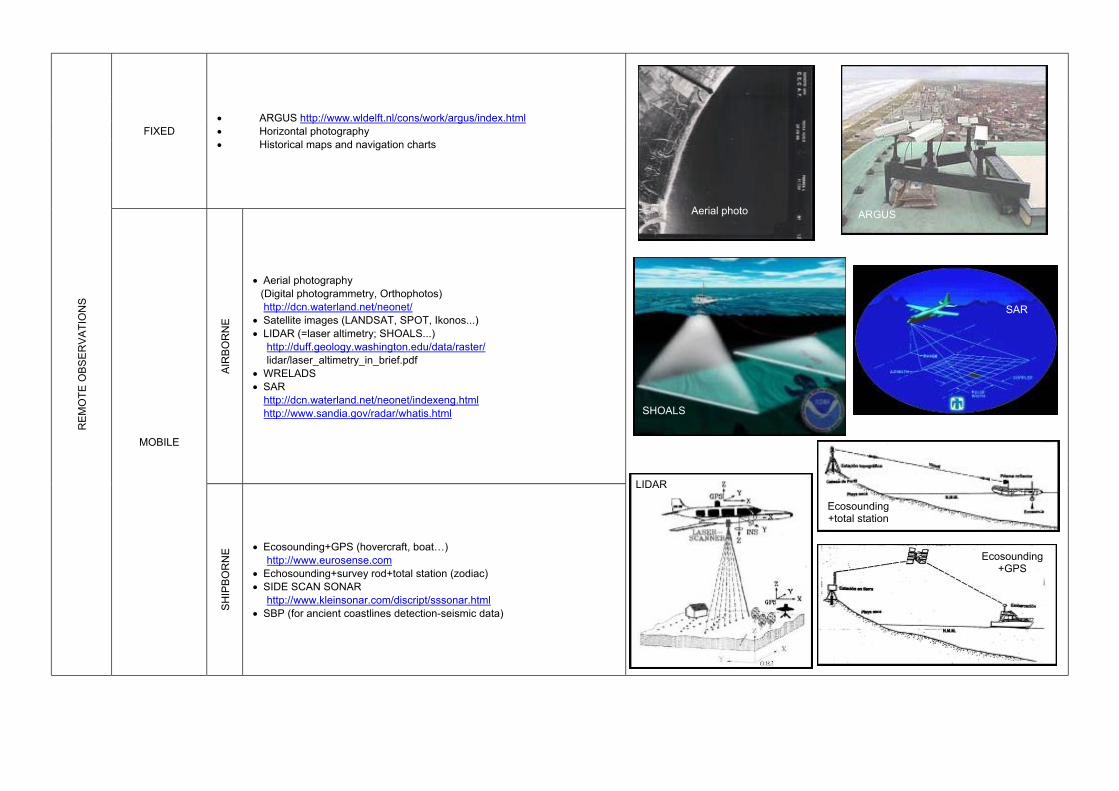
FIXED • ARGUS http://www.wldelft.nl/cons/work/argus/index.html • Horizontal photography • Historical maps and navigation charts
AI
RBO
RN
E
• Aerial photography (Digital photogrammetry, Orthophotos) http://dcn.waterland.net/neonet/ • Satellite images (LANDSAT, SPOT, Ikonos...) • LIDAR (=laser altimetry; SHOALS...)
http://duff.geology.washington.edu/data/raster/ lidar/laser_altimetry_in_brief.pdf
• WRELADS • SAR http://dcn.waterland.net/neonet/indexeng.html http://www.sandia.gov/radar/whatis.html
REM
OTE
OBS
ERVA
TIO
NS
MOBILE
SH
IPBO
RN
E • Ecosounding+GPS (hovercraft, boat…) http://www.eurosense.com
• Echosounding+survey rod+total station (zodiac) • SIDE SCAN SONAR
http://www.kleinsonar.com/discript/sssonar.html • SBP (for ancient coastlines detection-seismic data)
Ecosounding +GPS
Ecosounding +total station
ARGUS
SHOALS
LIDAR
SAR
Aerial photo