A Guide to a Waterwise Development - Water Corporation
86
The planning, design and approvals process for the OneOneFive Hamilton Hill residential infill development. A Guide to a Waterwise Development Digital version - not for print
Transcript of A Guide to a Waterwise Development - Water Corporation

The planning, design and approvals process for the OneOneFive Hamilton Hill residential infill development.
A Guide to a Waterwise Development
Digital version - not for print
PAGE II
Date Of Issue Rev # Purpose Of Review
Reviewed By Approved By
13/07/2020 0.1 WE Reference Group Review
JB JB
14/08/2020 0.2 Stakeholder Review JB JB19/10/2020 1.0 Final JB JB16/12/2020 1.1 Digital Version DH JB
Review Process
This document was prepared for Water Corporation by Josh Byrne & Associates
Images, graphics and designs provided by Water Corporation, Josh Byrne & Associates and VAM Media
© December 2020 - Digital version - Low resolution, not intended for print
AcknowledgmentsThe Guide to a Waterwise Development has been developed by Josh Byrne & Associates, supported by Water Corporation (financial), DevelopmentWA, Department of Water and Environmental Regulation and City of Cockburn via the OneOneFive Waterwise Exemplar program.

PAGE III
Preface
1 www.watersensitivecities.org.au
OneOneFive Waterwise Exemplar Program
The Guide to a Waterwise Development is an outcome of the first phase of the OneOneFive Waterwise Exemplar program, supported by Water Corporation, seeking to understand how innovative waterwise initiatives and Water Sensitive Urban Design (WSUD) can become mainstream practice in Perth’s development industry via investigation of the processes at the OneOneFive Hamilton Hill residential infill development. This first phase of the OneOneFive Waterwise Exemplar program considers the structure planning process and approvals for the site, and subdivision planning and approvals associated with the first of three stages of the development.
The Guide details a ‘Waterwise Development Pathway’, consisting of additional steps to the current statutory planning process for urban water management in land development. This pathway has emerged through learnings from the process of planning, design and approvals of integrated water management options for OneOneFive Hamilton Hill, including localised stormwater infiltration, the inclusion of an alternate water supply (community groundwater bore) for irrigation, and advanced water efficiency in buildings and the landscape. It is based on the identification of real barriers to adoption and how these are unpacked as part of the process of achieving a waterwise
development with excellent urban greening and liveability outcomes.
The Waterwise Development Pathway can be broadly applied to all types of development to assist with implementation of initiatives often viewed as difficult in the mainstream urban development industry. The intended audience includes land developers and land development consultants, local government, urban water professionals and associated stakeholders. Further information on the specific planning considerations, design and approvals of WSUD features such as permeable paving, water harvesting tree pits, roadside bio-filtration swales, underground stormwater retention systems and the community groundwater bore have been appended as fact sheets and a case study to the Guide.
As OneOneFive Hamilton Hill progresses, the Guide will be updated to include learnings captured during the construction and occupation phases of the project, as well as insights from the incorporation of innovative water management techniques and technologies during future development stages.
The waterwise attributes planned for the site, from which the learnings on planning, design and approvals have emerged, are detailed in the following table. These attributes are aligned with the relevant goals of a Water Sensitive City1, identified by the Cooperative Research Centre for Water Sensitive Cities (CRCWSC).

PAGE IV
OneOneFive Hamilton Hill
Total Area: 11.9haLot Yield: 232 (estimate)Dwellings: 320 (estimate)Density: 47 dwellings/ha (on total developable land)Public Open Space: 17% (inc southern bushland)

PAGE V
OneOneFive Waterwise Attributes Water Sensitive City GoalsTree retention and enhancement for urban cooling, ecological and amenity benefits.
• Targeting a 30% canopy cover.
• Retain approximately 77 existing trees.
• Planting additional 350 trees in public realm.
Ensure quality urban space.
Improve ecological health.
Retention of the natural topography of the site with stormwater controls to fit with this.
Large depth to water table and sandy permeable soils makes the site suitable for at-source stormwater control.
At-source stormwater infiltration methods include:
• Permeable paving in selected sections of roads and in all car bays.
• Roadside swales for enhanced soil moisture, plant health and landscape aesthetic.
• Water harvesting tree pits designed to support healthy tree growth and reduced reliance on irrigation.
• Approximately 75% of lots to contain 1% AEP event on lot to reduce size of stormwater infrastructure and promote localised infiltration.
• Underground retention chosen over basins in response to retaining existing trees where possible.
Promote adaptive infrastructure.
Ensure quality urban space.
Improve ecological health.
The project aims to minimise impact on remnant vegetation areas where possible, therefore the design excludes the intrusion of surface level drainage infrastructure on these natural areas, using underground retention to optimise public open space (POS) outcomes for conservation, useability and amenity.
Ensure quality urban space.
Improve ecological health.
Groundwater is available for irrigation of POS and private gardens, via a well-managed non-potable community groundwater bore scheme.
Promote adaptive infrastructure.
POS to include waterwise plants and hydrozoning.
Remote irrigation management with weather-based scheduling and automatic alerts of abnormal water use.
Ensure quality urban space.
Promote adaptive infrastructure.
Improve productivity and resource efficiency.
Private gardens designed in accordance with Design Guidelines with no more than 40% outdoor hardstand area (with a preference for permeable surfaces), waterwise softscaping with turf lawn limited to a maximum of 50% of the landscaped area.
Ensure quality urban space.
Improve ecological health.
Improve productivity and resource efficiency.

PAGE VI
OneOneFive Waterwise Attributes Water Sensitive City GoalsIrrigation must be connected to community groundwater bore scheme (if available).
A programmable automatic irrigation system including weather-based control must be used and set to relevant rostered watering days.
Water efficient in-line drip irrigation must be installed for all garden beds and spray irrigation only for turf areas.
Promote adaptive infrastructure.
Improve productivity and resource efficiency.
Rainwater tanks for houses on lots over 220m2. Dual plumbing to toilets and washing machines for connection of rainwater supply (now or in future) and provide sufficient space for the installation of a rainwater tank (min 3000 litres) close to downpipes with a minimum roof catchment of 70m2, an external power outlet, a garden tap or mains water take off point and dual plumbing pipe work.
Promote adaptive infrastructure.
Greywater ready: bathroom and laundry plumbing to comply with the Residential Greywater Ready Plumbing Guidelines (only applies to houses on lots over 270m2).
Promote adaptive infrastructure.
Water efficient fixtures and fittings:
• Shower heads that use less than 7.5 litres per minute (WELS 3-star).
• Taps to bathrooms, kitchen and laundry that use 6 litres per minute or less (WELS 3-star).
• Dishwasher consumption of <=14 litres per use (WELS 5-star).
• Washing machine consumption <=110 litres per use (WELS 4-star).
Improve productivity and resource efficiency.
Increase community capital.
Behaviour initiatives proposed, such as residents provided with information on water consumption, including fault alerts, via a digital smart platform.
Improve productivity and resource efficiency.
Increase community capital.
Ongoing collaboration between stakeholders to ensure desired outcomes are met throughout the development process.
Ensure good water sensitive governance.

PAGE VII
Contents
Preface IIIOneOneFive Waterwise Exemplar Program IIIOneOneFive Hamilton Hill IV
Introduction 1OneOneFive Waterwise Exemplar 1Waterwise Perth 2Water Corporation Waterwise Development Program 2Using the Guide 3
Method 4Desktop review 4
Waterwise Development Pathway 8Project definition 10Concept planning, master plan and local structure plan 12Subdivision plan and detailed design 23Next steps: construction, occupation, maintenance 28
References 29
Appendix 32APPENDIX 1 Waterwise Development Pathway Schematic
APPENDIX 2 Permeable Paving Fact Sheet
APPENDIX 3 Water Harvesting Tree Pits Fact Sheet
APPENDIX 4 Roadside Bio-filtration Swales Fact Sheet
APPENDIX 5 Underground Stormwater Retention Systems Fact SheetAPPENDIX 6 Community Groundwater Bore Case Study
PAGE 1
Introduction
The OneOneFive Waterwise Exemplar program uses the OneOneFive Hamilton Hill residential infill project by DevelopmentWA to investigate, document and communicate how innovative waterwise initiatives and WSUD can become mainstream practice in Perth’s urban development industry.
OneOneFive Waterwise Exemplar The program has a specific focus on the process of implementation, overcoming barriers, sharing learnings and building capacity for change for improved urban water management among local government, developers and their consultants.
Specifically created for the OneOneFive Hamilton Hill ‘Innovation by Demonstration’ project by DevelopmentWA, the Waterwise Exemplar program uses the development as a live platform for investigation. The 11.9ha residential infill development includes approximately 232 lots (and 320 future dwellings) on the former Hamilton Senior High School site, located in the City of Cockburn.
DevelopmentWA is committed to providing leadership in demonstrating liveability and sustainability outcomes in urban development. The project team are aiming to set a new standard for residential infill development across the four elements of:
• Community wellbeing • Environmental responsibility• Economic health• Design excellence
Phase 1 of the program focuses on the planning, design and approvals process for IUWM and WSUD initiatives at the structure plan and Stage 1 subdivision level, with learnings captured in this Guide to a Waterwise Development.
The Guide details a ‘Waterwise Development Pathway’, consisting of additional steps complimentary to the standard development processes (concept, masterplan, local structure plan and subdivision plan) and corresponding statutory requirements as outlined in Better Urban Water Management (WAPC, 2008). These additional pathway processes are
intended to encourage better uptake of innovative water management practices in urban developments to achieve improved urban greening and liveability outcomes.
The Waterwise Development Pathway has emerged from navigating barriers encountered during the planning, design and approvals of urban water management approaches at OneOneFive Hamilton Hill, specifically localised stormwater infiltration for landscape hydration, the investigation of a non-drinking water supply (community groundwater bore) and advanced water efficiency in buildings and within the landscape.
Future versions of this Guide will include learnings from Phase 2 of the OneOneFive Waterwise Exemplar program as the project moves through construction and land sales, as well as Phase 3 which will cover operation, maintenance and monitoring of water use. Emerging waterwise techniques and technologies will be tested in subsequent development stages, with the process documented and shared through industry forums, publications and updates to the Guide.
The OneOneFive Waterwise Exemplar program has been financially supported by Water Corporation, however several other stakeholders play a key role in program direction and decision making. These include: DevelopmentWA, Department of Water and Environmental Regulation (DWER) and the City of Cockburn. A Memorandum of Understanding (MoU) between Water Corporation and DevelopmentWA has been signed to ensure a partnership is in place for the delivery of waterwise outcomes at OneOneFive Hamilton Hill and to demonstrate leadership by state government organisations in urban water management.
PAGE 2
2 A network of champions formed to advance the water sensitive/waterwise journey for Perth.
Waterwise PerthThe current urban water vision for Perth is to become a leading waterwise city by 2030 and the Waterwise Perth Action Plan (DWER, 2019) sets the direction for this transition. With climate change impacts already experienced in Perth, such as reduced rainfall and increased temperatures, coupled with population growth, the way water is sourced, used and planned for urban spaces is critical to achieving the vision.
As households and green spaces account for most of the water use in Perth by sector (53% and 15% respectively; DWER, 2019), the design of residential development sites provides an opportunity for change. In addition, demonstration projects can provide an avenue to test, revise, validate and understand waterwise approaches.
The OneOneFive Waterwise Exemplar program supports the waterwise vision for Perth and responds to some of the associated strategic aims and actions as detailed in the Water Sensitive Transition Network2 2019 report and the Waterwise Perth Action Plan (WPAP) (DWER, 2019).
Water Corporation Waterwise Development ProgramThe Waterwise Development Program recognises best practice outcomes by developers in creating waterwise communities. The program has recently expanded from a water efficicency focus to now include outcomes that align with the principles of a waterwise city and goals from the CRCWSC Water Sensitive Cities Index3.
Automatic endorsement is awarded if the development meets the water category certification requirements of a recognised industry sustainability program, such as EnviroDevelopment, GreenStar, One Planet Living and the Living Community Challenge.
Gold recognition requires demonstration of achieving Water Sensitive City goals:
• Governance and community capital • Productivity, resilience and resource
efficiency• Ecological health and quality urban space
Platinum recognition requires further information and evidence on how a project demonstrates genuine industry leadership.
3 www.watersensitivecities.org.au/solutions/wsc-index
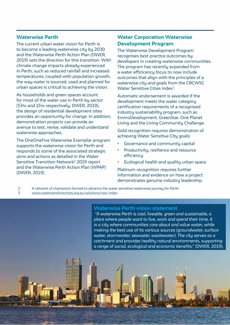
Waterwise Perth vision statement “A waterwise Perth is cool, liveable, green and sustainable, a place where people want to live, work and spend their time. It is a city where communities care about and value water, while making the best use of its various sources (groundwater, surface water, stormwater, seawater, wastewater). The city serves as a catchment and provides healthy natural environments, supporting a range of social, ecological and economic benefits.” (DWER, 2019).

PAGE 3
Using the GuideIntegrated urban water management (IUWM) approaches are dependent upon the site-specific context (physical, historical, social and economic), the aims and values of stakeholders and the proposed development approach or philosophy. There is no one size fits all. It is acknowledged that a large amount of Perth’s urban growth will take place in areas where groundwater allocation is limited or unavailable, and where the hydrological conditions are more challenging than OneOneFive Hamilton Hill.
Nonetheless, the Guide to a Waterwise Development and the documented Waterwise Development Pathway is broadly applicable, particularly as there is a focus on embedding waterwise approaches into the project definition and vision early, ensuring the project team and stakeholder expectations align. The learnings are transferable to other development types (i.e. greenfield) and geographical contexts across Perth given the focus on the process, governance and engagement requirements
for project planning, design and approvals. Examples and key outcomes from OneOneFive Hamilton Hill are provided throughout the Guide as a working example.
Many of the barriers to mainstream implementation have been recognised at the post implementation stage, such as construction not matching design intent, unviable business cases, and operation and maintenance responsibilities (Sharma et al. 2016). It is hoped that over time as more on-ground projects apply the Guide, it can evolve to incorporate additional learnings and case studies to ensure greater understanding, improved applicability and progress towards a more waterwise Perth.
The complete Guide to a Waterwise Development will add to the suite of urban water guides specifically written for WA, such as the Community Bore Guide (Water Corporation, 2018) and the West Australian Greywater Guide (Water Corporation, 2019).
Achieving urban infill in PerthAccommodating 3.5 million people by 2050, as per the Perth and [email protected] requires a mix of urban infill (47% target) and greenfield (53% target) development.
The importance of a considered approach to urban infill is of utmost importance to accommodate additional complexities and costs such as working with and meeting the expectations of an established community, existing (often aging) infrastructure, urban heat stress, retaining landform and biodiversity. Urban infill developments need to be site responsive, which includes the responsible use of available groundwater.
The State Government’s METRONET project is a sustainable approach to growing our city via urban infill and contributes well planned and integrated transport infrastructure to shape more diverse, compact and connected communities around transport nodes.

PAGE 4
Method
The Guide is an outcome of an applied research approach used for the OneOneFive Waterwise Exemplar program to understand the planning and approvals process for the implementation of WSUD in urban development, using the learnings from OneOneFive Hamilton Hill. Applied research is adopted when a problem needs to be solved, with the intent of a study to contribute the knowledge of that problem and findings to assist in developing solutions (Bickman and Rog, 1998).The methodology to investigate the planning and approval process includes:
• Desktop review of guidelines, academic literature and anecdotal evidence on barriers and challenges to implementation of WSUD.
• Review of supporting policies, planning frameworks and governance arrangements.
• Data collection via stakeholder discussions/workshops on planning and approvals process and observation.
• Data synthesis, reporting and recommendations: A Guide to a Waterwise Development.
Desktop reviewRationale for IUWM and WSUD approachIncreasingly, Australian urban developments are incorporating IUWM with WSUD at a range of development scales such as greenfield, infill and retrofit (Sharma et al., 2012). IUWM is the long-term holistic planning that integrates multiple water sources with various stakeholders and urban planning (Byrne et al., 2018). WSUD is a part of IUWM focusing on solutions that incorporate the water cycle into the local context, including green infrastructure, to improve liveability and environmental outcomes (Furlong et al., 2016; Tjandraatmadja, 2018). Combined, these approaches aim to replace use of drinking water for non-potable consumption and reduce the strain on centralised sources with alternative sources such as rainwater harvesting; stormwater harvesting; groundwater extraction and treatment; greywater collection and treatment; and wastewater collection and treatment (Byrne, 2016; Sharma et al., 2012). Benefits include promoting a more natural water cycle, local source diversification, resource efficiency and providing decentralised solutions (Marlow et al., 2013). They also have
the potential to increase biodiversity, ecological health, landscape aesthetic and amenity; which can add to the distinct character, identity and sustainability of a place (Johnstone et al., 2012; Lehmann, 2010) providing a context specific identity that connects the community to its natural and cultural context. Moreover, these urban water management approaches assist in managing public health, urban microclimates and heat mitigation (Johnstone et al., 2012).
Current opinion and consensus indicates that progress on changing from a traditional centralised water delivery approach to an integrated approach is slow, despite the technical and scientific aspects of urban water management being well understood; it is the institutional setting and capacity, financial considerations, flexibility with changing technology and community understanding/acceptance that still requires attention (Keremane et al. 2017; Marlow et al. 2013). A review of water governance studies in Australia indicates that social and institutional barriers include: insufficient practitioner skills and knowledge, organisational resistance, lack of political will, limited regulatory incentives and lack of institutional capacity (Keremane et al. 2017). These barriers have appeared alongside the new paradigm of urban water management that began in the 1990s when conventional water management systems were recognised as unsustainable and began to change into water management systems integrated with land use policy, planning, development approvals process, construction, economics, regulation and legislation, education, social acceptance and community involvement (Mitchell, 2006), adding additional layers of procedural and operational complexity.
Wong and Brown (2008) suggest that transforming towards a Water Sensitive City4

PAGE 5
needs to focus on ‘how’ to ensure a connection between urban water management, urban design and social and institutional systems. Therefore, fostering good working relationships between stakeholders, well communicated processes, and demonstration projects need to accompany sound technical knowledge to assist in ensuring that future implementation of WSUD and IUWM is successful. The OneOneFive Waterwise Exemplar program aims to contribute to this required level of knowledge and shared learnings.
Technical guidelines (existing resources)A comprehensive review of WSUD guidelines has been completed by Sharma et al. (2018) examining the national, regional, and local planning and design guidelines developed by various national, state, and local agencies for the sustainable implementation of WSUD systems. As noted by the authors (Sharma et al., 2018, p.75-76) “These guidelines help water professionals, designers, planners, and managers to plan, design, and implement these approaches based on urban development requirements, water quality and hydrology criteria, catchment characteristics, local climatic conditions, local regulations, and environmental and community considerations.”
Practitioners have access to a variety of guidance documents where the science has been unpacked on various WSUD tools and systems. Sharma et al. (2018) provide links
to specific guidelines and documentation for a variety of WSUD systems and techniques. Design criteria have also been outlined, with a focus on water quality management and protection. The review by Sharma et al. (2018) provides an excellent overview of the available technical guidelines and highlights the importance of considering the design objectives and site constraints during implementation and the various data requirements for WSUD system planning and design.
A key guidance document for WSUD implementation in Western Australia (WA) is Better Urban Water Management (BUWM) (WAPC, 2008). The BUWM process is designed to facilitate better management and use of our urban water resources by ensuring appropriate consideration of the total water cycle is given at each planning stage. BUWM provides guidance on the required planning processes consistent with the State Water Plan (WA Gov, 2007), State Water Strategy (WA Gov, 2003), State Planning Strategy (WAPC, 1997), Liveable Neighbourhoods (WAPC, 2007) and State Planning Policy 2.9 Water Resources (WAPC, 2006).
Table 1 summarises some of the available resources and guidelines that provide technical details specific to implementing WSUD in WA.
Table 1: WA WSUD guidelines
Type Summary ResourceWAPC: Better Urban Water Management
A framework for how water resources should be considered at each planning stage.
Checklists with technical considerations to aid preparation of water management strategy documents.
Department of Water and Environmental Regulation: Urban water design
DWER is responsible for protection, conservation and management of water resources, therefore provides advice and WSUD design brochures to guide implementation and links to formal BUWM.
www.water.wa.gov.au/urban-water/urban-development/urban-water-design
https://www.water.wa.gov.au/urban-water/urban-development/stormwater/stormwater-management-manual (includes Decision Process for Stormwater Management)
4 www.watersensitivecities.org.au
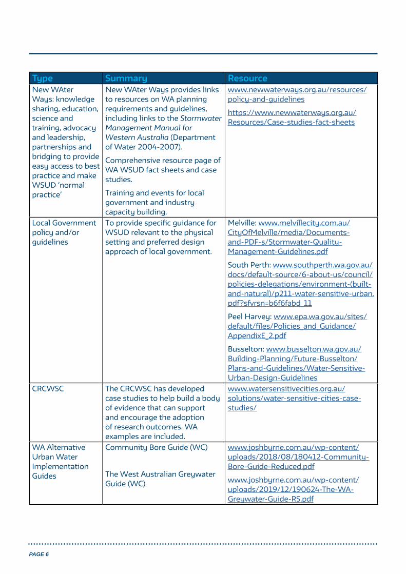
PAGE 6
Type Summary ResourceNew WAter Ways: knowledge sharing, education, science and training, advocacy and leadership, partnerships and bridging to provide easy access to best practice and make WSUD ‘normal practice’
New WAter Ways provides links to resources on WA planning requirements and guidelines, including links to the Stormwater Management Manual for Western Australia (Department of Water 2004-2007).
Comprehensive resource page of WA WSUD fact sheets and case studies.
Training and events for local government and industry capacity building.
www.newwaterways.org.au/resources/policy-and-guidelines
https://www.newwaterways.org.au/Resources/Case-studies-fact-sheets
Local Government policy and/or guidelines
To provide specific guidance for WSUD relevant to the physical setting and preferred design approach of local government.
Melville: www.melvillecity.com.au/CityOfMelville/media/Documents-and-PDF-s/Stormwater-Quality-Management-Guidelines.pdf
South Perth: www.southperth.wa.gov.au/docs/default-source/6-about-us/council/policies-delegations/environment-(built-and-natural)/p211-water-sensitive-urban.pdf?sfvrsn=b6f6fabd_11
Peel Harvey: www.epa.wa.gov.au/sites/default/files/Policies_and_Guidance/AppendixE_2.pdf
Busselton: www.busselton.wa.gov.au/Building-Planning/Future-Busselton/Plans-and-Guidelines/Water-Sensitive-Urban-Design-Guidelines
CRCWSC The CRCWSC has developed case studies to help build a body of evidence that can support and encourage the adoption of research outcomes. WA examples are included.
www.watersensitivecities.org.au/solutions/water-sensitive-cities-case-studies/
WA Alternative Urban Water Implementation Guides
Community Bore Guide (WC)
The West Australian Greywater Guide (WC)
www.joshbyrne.com.au/wp-content/uploads/2018/08/180412-Community-Bore-Guide-Reduced.pdf
www.joshbyrne.com.au/wp-content/uploads/2019/12/190624-The-WA-Greywater-Guide-RS.pdf

PAGE 7
Guidance on planning and design process Whilst a variety of guidelines are available to inform technical design, the ideal process of implementation is not as widely understood or documented. Researchers and observers have provided guidance for IUWM and WSUD planning processes. Tjandraatmadja (2018) notes that adoption is still not mainstream, clear targets and objectives require support in and alignment of policy and legislation, cross agency collaboration and creation of new implementation roles to increase effectiveness, and flexibility and adaptability as needs and barriers change over time. Cook et al. (2015) suggests that effort has been made to incorporate the principles of WSUD into the planning and development process at state
and local government levels, however actual implementation is left to local government through local planning schemes (e.g. City of South Perth WSUD Policy).
Some guidance and examples are provided on planning processes, either for broader IUWM planning processes (e.g. Maheepala et al., 2010) and for WSUD (e.g. SA Govt Department of Local Government and Planning, 2010) to help inform a consistent approach to the planning, design and decision making process of WSUD measures for urban developments.
Examples of planning and design processes that have informed the development of the Waterwise Development Pathway and adapted to suit the WA urban water planning and management context are summarised in Table 2.
Table 2: Guidance for IUWM and WSUD planning processes
IUWM planning process (Maheepala et al., 2010)
Designing a WSUD strategy for your development (SA Govt, 2010)
WSUD guidelines: South Eastern Councils (Melbourne Water, 2013)
• Convene a stakeholder group and engage a project champion
• Agree on objectives, measures and criteria.
• Understand the current system
• Assess system performance and select portfolios (social, environmental, economic)
• Implementation planning
12 step guide to the design process:• Understand the site• Identify objectives &
targets• Identify suitable WSUD
measures• Meet with council &
relevant authorities• Conceptual site design
(may occur before meeting)• Model base case• Locate WSUD measures• Model treated case• Objectives check• Finalise measures• Obtain approvals• Undertake detailed design
• Step 1: Early planningPlanning meetingPrelim site assessmentWSUD strategy and targetsPreferred WSUD systemsPreliminary design, construction and maintenance considerations• Step 2: Site assessment• Step 3: Concept design• Step 4: Submission of
concept design• Step 5: Detailed design• Step 6: Submission of
detailed design

PAGE 8
Waterwise Development Pathway
The Waterwise Development Pathway has been developed to address implementation issues identified by WA urban water professionals, development industry stakeholders and academic literature.
The Waterwise Development Pathway also melds together previously published implementation (planning, approvals and design) processes with the learnings from participation in BUWM as part of the OneOneFive Waterwise Exemplar program and OneOneFive Hamilton Hill project. It promotes a holistic and integrated developer led approach to ensure the role and impact of all urban water and WSUD initiatives are considered together, and alongside site landscape, energy and waste initiatives for collective impact and better urban greening and liveability outcomes.
The Waterwise Development Pathway outlines additional steps alongside existing site
development and BUWM processes, to achieve advanced waterwise outcomes. For the purpose of this Guide, the process has commenced at the Local Water Management Strategy (LWMS) stage, as per the OneOneFive Hamilton Hill experience and learnings, whereas the BUWM process includes the earlier two stages: Regional and sub-regional (e.g. Regional Water Management Strategy) and District (District Water Management Strategy).
The Waterwise Development pathway currently flows through:
• Planning, design and approvals• Construction, occupation, maintenance
District Water Management StrategyA OneOneFive DWMS was prepared by Essential Environmental (2015) to support rezoning of the site from Public Purposes – High School to Urban Development and was approved by the Department of Water (DoW, now Department of Water and Environmental Regulation (DWER)) in 2016. This planning component of the process took place before the OneOneFive Waterwise Exemplar program commenced.
The following sections of this Guide distill the components of the Waterwise Development Pathway, spanning the planning, design and approvals activities, using case study examples from OneOneFive Hamilton Hill and the OneOneFive Waterwise Exemplar program where relevant. Further content covering the construction, maintenance and occupation activities will be included as OneOneFive Hamilton Hill and Waterwise Exemplar program progress.
PAGE 9
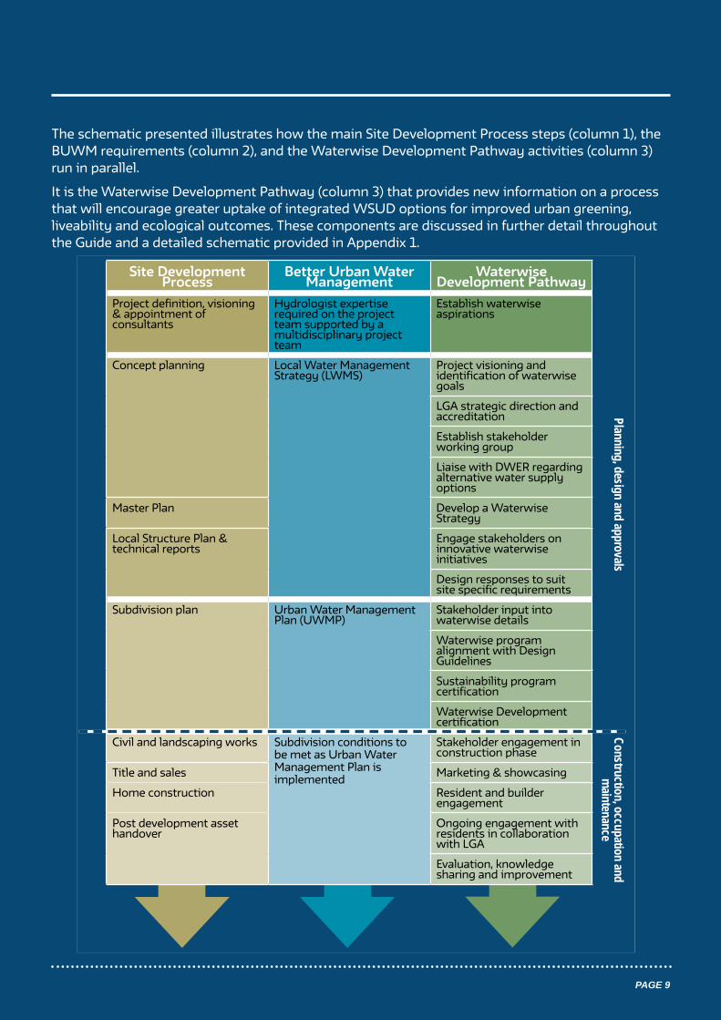
The schematic presented illustrates how the main Site Development Process steps (column 1), the BUWM requirements (column 2), and the Waterwise Development Pathway activities (column 3) run in parallel.
It is the Waterwise Development Pathway (column 3) that provides new information on a process that will encourage greater uptake of integrated WSUD options for improved urban greening, liveability and ecological outcomes. These components are discussed in further detail throughout the Guide and a detailed schematic provided in Appendix 1.
Site Development Process
Better Urban Water Management
Waterwise Development Pathway
Project definition, visioning & appointment of consultants
Hydrologist expertise required on the project team supported by a multidisciplinary project team
Establish waterwise aspirations
Concept planning Local Water Management Strategy (LWMS)
Project visioning and identification of waterwise goals
LGA strategic direction and accreditation
Establish stakeholder working group
Liaise with DWER regarding alternative water supply options
Master Plan Develop a Waterwise Strategy
Local Structure Plan & technical reports
Engage stakeholders on innovative waterwise initiatives
Design responses to suit site specific requirements
Subdivision plan Urban Water Management Plan (UWMP)
Stakeholder input into waterwise details
Waterwise program alignment with Design Guidelines
Sustainability program certification
Waterwise Development certification
Civil and landscaping works Subdivision conditions to be met as Urban Water Management Plan is implemented
Stakeholder engagement in construction phase
Title and sales Marketing & showcasing
Home construction Resident and builder engagement
Post development asset handover
Ongoing engagement with residents in collaboration with LGA
Evaluation, knowledge sharing and improvement
Construction, occupation and m
aintenancePlanning, design and approvals

PAGE 10
Site Development Process Better Urban Water Management
Waterwise Development Pathway
Project definition, visioning and appointment of consultants
Urban water and hydrologist expertise required on the project team supported by a multidisciplinary project team (planner, civil engineer and landscape architect)
Establish waterwise aspirations• Waterwise and sustainability
aspirations identified in the consultant’s brief
Project definition
The project definition stage is where the development intent is defined and a multidisciplinary team of technical professionals appointed. Waterwise aspirations need to be identified, as per the Waterwise Development Pathway.
An important aspect of OneOneFive Hamilton Hill is to retain the natural topography of the site. This is respectful to the traditional owners of the site, as it was a strategic lookout, connected to Fremantle and Cockburn coasts, lakes (Bibra Lake) and swamps to the East, and is connected by mythology, dreaming and a personal connection to country (Terra Rosa, 2017).
Establish waterwise aspirationsOne of the first steps to creating a waterwise development is for the proponent to define the overall vision for the site, including establishing project objectives, sustainability goals and waterwise aspirations. Ideally, aspirations should be included in the consultant tendering process to ensure the appointed team can meet the required expectations for the project, align with the vision, sustainability goals and commit to achieving best practice outcomes. A project vision will be further defined and refined during the proceeding planning stages and the project-specific solutions and responses conceptualised and solved by the project team, however, these processes will be continually guided by the overarching vision and objectives of the project.
Waterwise aspirations and sustainable design principles should consider indigenous connections to the land and the natural landscape of the site (e.g. topography, remnant bushland, water bodies, environment and sustainability) and the current cultural and economic context in which it is situated. At this stage, the long-term value and co-benefits of adopting a WSUD approach should be considered and communicated. Early contact with local government environment and sustainability officers, in addition to engineers and planners, regulatory bodies and other relevant government agencies will assist in establishing waterwise aspirations and a common understanding moving forward.

PAGE 11
DevelopmentWA’s commitment to sustainable developmentDevelopmentWA defined their commitment to sustainable development in the tendering process. This included detailing the four sustainability elements that form DevelopmentWA’s framework to integrate sustainable development across a range of projects: community wellbeing, design excellence, environmental responsibility, economic health.
Indigenous engagement was highlighted as an important part of the project, at all stages. A preliminary vision for the site was provided and objectives outlined, aligning with the four sustainable elements. Sustainability aspirations were also set with the desired multidisciplinary consultant team defined, including roles for urban design planning, architect, social/cultural/heritage consultants, environmental consultants, engineers, landscape architect, surveyor, arboriculturalist, property consultant, public relations and marketing.

PAGE 12
Concept planning, master plan and local structure plan
In line with BUWM, a project team typically commences urban water related investigations and other related technical work from concept planning stage to inform the preparation of a LWMS.
Site Development Process Better Urban Water Management
Waterwise Development Pathway
Concept planning • Site and context analysis;
constraints and opportunities• Identification of environmental
assets• Identification of strategic drivers• Develop sustainability objectives• Community and stakeholder
consultation
Local Water Management Strategy (LWMS)
• Groundwater quality and level monitoring
• Surface water quality and quantity (volumes, flow rates and flood level) monitoring
• Water balance• Hydrological modelling• Infrastructure needs• Confirmation of potable,
non-potable and wastewater servicing arrangements
• Management of water/environmental assets and enhancement opportunities
• Specific management practices for stormwater
• Conceptual landscape outcomes
Project visioning and identification of waterwise goals (entire project team)
LGA strategic direction and accreditation• Cross check LGA Waterwise
Council status, Water Sensitive City Benchmarking and other strategic urban greening/liveability programs
Establish stakeholder working group to inform and support waterwise initiatives
Liaise with DWER, Local Government and/or service provider regarding alternative water supply options(e.g. recycled water scheme or community bore) and undertake business case
Master Plan• Decide suitable sustainability
framework • Landscape Master Plan• Community and stakeholder
engagement
Develop a Waterwise Strategy for the project:• Align w/ project team• Brief stakeholders (inc LGA)
Local Structure Plan & technical reports• Establish land use, density and
public open space (Landscape Master Plan)
• Environmental features and protection
• Movement network• Engineering and environmental
requirements • Local Water Management Strategy• Community and economic
development
Engage stakeholders on innovative waterwise initiatives
Design responses to suit site specific requirements
Engagement activities often take place between a development proponent and other stakeholders as part of early site investigations prior to this stage. Urban water management considerations for the site may arise during these early engagement activities, however the commencement of concept planning and the LWMS process is a practical point to commence the Waterwise Pathway.
The LWMS is considered the most crucial stage of water planning as waterwise principles are demonstrated within the conceptual layout of roads, public open space and greater structure plan design (DWER, pers comm. 2020). At this point, technical consultants will have been appointed, and formal engagement with the Local Government Authority (LGA) and state agencies should begin.
A Local Water Management Strategy (JBA, 2020) was prepared by Josh Byrne & Associates, in line with Better Urban Water Management, WAPC 2008 and in conjunction with Hyd20 and TABEC, on behalf of DevelopmentWA to accompany the Local Structure Plan prepared by Hames Sharley (2018). The LWMS was approved by DWER on the 22/4/2020.
PAGE 13
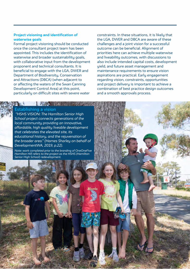
Project visioning and identification of waterwise goalsFormal project visioning should be conducted once the consultant project team has been appointed. This includes the identification of waterwise and broader sustainability goals, with collaborative input from the development proponent and technical consultants. It is beneficial to engage with the LGA, DWER and Department of Biodiversity, Conservation and Attractions (DBCA) (when adjacent to or affecting the waters of the Swan Canning Development Control Area) at this point, particularly on difficult sites with severe water
constraints. In these situations, it is likely that the LGA, DWER and DBCA are aware of these challenges and a joint vision for a successful outcome can be beneficial. Alignment of priorities here can achieve multiple waterwise and liveability outcomes, with discussions to also include intended capital costs, development yield, and future asset management and maintenance requirements to ensure vision aspirations are practical. Early engagement regarding vision, constraints, opportunities and project delivery is important to achieve a combination of best practice design outcomes and a smooth approvals process.
Establishing a vision “HSHS VISION: The Hamilton Senior High School project connects generations of the local community providing an innovative, affordable, high quality liveable development that celebrates the elevated site, its educational history, and the rejuvenation of the broader area.” (Hames Sharley on behalf of DevelopmentWA, 2019, p.22).Note: work completed prior to the branding of OneOneFive Hamilton Hill refers to the project as the HSHS (Hamilton Senior High School) redevelopment.

PAGE 14
Importance of OneOneFive Hamilton Hill site context in informing landscape and water responses to achieve liveability outcomesThe unique site context formed the basis of the Landscape Master Plan Report (Josh Byrne & Associates, 2018), created to provide direction on overall landscape design intent for the development and responses to the site considerations. The following list details the landscape and waterwise initiatives proposed for the site and important site characteristics:
• Undulating topography, a central hilltop with excellent views and highly permeable sandy soils.
• Large depth to groundwater and no receiving waterways.
• Site situated as part of a larger ecological bushland reserve and habitat corridor.
• Cultural influences, both Indigenous and European communities to be accurately reflected.
• 229 existing trees, with a total of 16% existing tree canopy. 34% of the mature trees have been retained as part of the Landscape Master Plan, with the road layout designed for retention and expansion of canopy cover.
• An additional 350 new trees are proposed across the site in public landscape areas, street verges and laneways; targeting an achievement of 30% canopy cover across the site (20% in public realm and an additional 10% in the private realm).
• A series of neighbourhood parks to be provided, connected by landscape public access ways and verges to ensure ready access to green space.
• Nature based play to be incorporated into the remnant vegetation areas to foster connection with the local environment.
• A range of landscape features are proposed including permeable paving, tree pits, and vegetated swales to contribute to at-source infiltration of stormwater to enhance soil moisture, plant health, tree growth and contribute to urban cooling.

PAGE 15
LGA strategic direction and accreditation Although not a formal requirement of the development planning and approvals process, it is helpful to know whether a LGA is recognised as a Waterwise Council, as part of understanding their current position and aspirations. Integrated water management initiatives for a development project that align with LGA aspirations can reinforce an existing waterwise position or assist a local government in achieving further Waterwise Council status, such as Gold or Platinum5.
Knowing whether an LGA has undertaken Water Sensitive City Benchmarking6 is also important here as the results and action plan can align with proposed waterwise options and assist in discussions about on-ground actions to progress the LGA’s waterwise journey. In addition, understanding an LGA’s position on urban greening, liveability and strategic direction will help to identify opportunities for mutually beneficial waterwise initiatives.
City of Cockburn - Gold Waterwise CouncilThe Waterwise Council Program supports councils to improve their water efficiency and water management to help create a Waterwise Perth and waterwise communities.
Established in 2009 the program is a partnership between Water Corporation and DWER, with over 64 councils taking part reaching over 1.8 million residents.
The City of Cockburn has continued to be endorsed as a Gold Waterwise Council since 2015 (WC, 2020). This has been achieved through many different initiatives that amplify water efficiency and conservation within the City, such as implementing the Water Efficiency Action Plan and retrofitting of City facilities with water efficiency measures, buildings and POS.
Recently, the City has been applying an Environmental Sustainable Design Policy (ESD). This policy provides a mechanism for water reduction initiatives to be implemented, such as the use of alternative water supplies, water reuse systems and water conservation devices. Furthermore, the City’s staff are tasked with leak reporting and water conservation issues and ideas are discussed at team meetings. The City encourages residents to play a role in waterwise behaviours through offering residents a native plant subsidy scheme, waterwise verge rebate program and a home eco audit program.
City of Cockburn Water Sensitive Cities IndexThe City of Cockburn council area was benchmarked using the WSC Index Tool in February 2018. As part of the OneOneFive Waterwise Exemplar program, an analysis of the Council’s Twelve Point Plan was conducted to assess how the OneOneFive development and Waterwise Exemplar program can assist the City in its waterwise journey and ongoing reporting. Key areas of alignment include combating urban heat, understanding WSUD maintenance costs, greater protection and management of groundwater, and co-design of water sensitive projects.
5 www.watercorporation.com.au/Help-and-advice/Waterwise-business-programs/Waterwise-Council-Program/ About-our-program6 www.watersensitivecities.org.au/content/water-sensitive-cities-index

PAGE 16
OneOneFive Waterwise Exemplar program reference groupTo facilitate collaborative partnerships and approaches, and to receive project direction, a OneOneFive Waterwise Exemplar Reference Group was formed and quarterly meetings held, each focusing on a different OneOneFive Waterwise Exemplar program activity. The Reference Group includes the following key partner organisations:
• Water Corporation
• DevelopmentWA
• Department of Water and Environmental Regulation (DWER)
• City of Cockburn
• Josh Byrne & Associates
The organisations represented were carefully selected to ensure that all facets of urban water management for OneOneFive Hamilton Hill were included.
Liaise with DWER and relevant stakeholders regarding alternative water supply optionsProposed alternative water supply systems for a site need to be discussed with DWER early in the planning process. These discussions will ensure options proposed are suitable for the site, the broader area and catchment. The intended service provider (e.g. LGA) needs to be engaged early on to provide input into design aspirations. Investigations should also utilise the ‘Guidelines for the approval of non-drinking water systems in Western Australia’ (DoW, 2013) for information on general considerations and specific approval requirements for establishing a non-drinking water system in an urban development.
The suitability of including an alternative water
supply (such as a community groundwater bore or recycled water scheme) in a project will depend on a number of factors including the scale of the development, business case and the degree to which the development site is water constrained. Traditionally, the development industry in Perth has not been successful in incorporating alternative water schemes into projects. Interest in development-scale (and district-scale) alternative water schemes is growing in recognition of Perth’s drying climate to ensure adequate water for the irrigation of public and private open space. Historical concerns over regulatory barriers are now largely unfounded. The greatest challenge is ensuring alternative water supplies have a robust business case to support viability.
Establish a stakeholder working group A stakeholder working group should be established to support and inform the waterwise direction of the development. This group should be multi-disciplinary and multi-agency to ensure a holistic response towards site options and appropriate interrogation of WSUD concepts as the site design progresses. Project consultants will need to be aware of stakeholder motivations and the challenge of finding deliverables that respond to collective viewpoints. Engagement need not be onerous, just committed, and expectations of the group should be agreed upon early on.
Ensure there is appropriate internal representation from local government departments covering environment, planning, engineering and parks, and a shared understanding of project principles. It is a common experience for development proponents and their technical consultants to hit barriers with LGA approval of WSUD initiatives. Having early engagement with City officers, and better still their buy in, and the benefit of their experience and insights, greatly increases the likelihood of a successful outcome.

PAGE 17
Proposed community groundwater bore scheme for OneOneFive Hamilton HillOneOneFive Hamilton Hill is fortunate to be located where there is an available groundwater allocation of suitable quality for irrigation. On this basis, a community groundwater bore scheme for the irrigation of residential gardens and POS was investigated, following the process outlined in the Water Corporation Community Bore Guide (Water Corporation, 2018). The process included:
• An initial investigation that indicated groundwater may be available for irrigation given the previous allocation for the irrigation of school grounds (e.g. via DWER Water Register and site groundwater investigations).
• An application submitted to DWER, detailing estimated irrigation requirements.
• A follow-up meeting with DWER to discuss site specific requirements and responsible groundwater use at the site, via metering and monitoring.
• An approved licence issued in May 2019.
• Ongoing conversations with the City of Cockburn regarding their preference for a community groundwater bore scheme, resulting in the development of a business case (see appended Community Groundwater Bore Case Study).

PAGE 18
Develop a Waterwise StrategyThe early formation of strategies to approach water, energy, waste and other sustainability considerations is an important step in a project achieving its defined vision. The preparation of a Waterwise Strategy during the concept and master planning stages is an opportunity to document ideas and test different waterwise scenarios that might be applied across the life of a development. It is a way to ensure concepts are included early on in project team discussions and a chance to capture input from other stakeholders. It is also a way to identify opportunities for innovation. It is the thinking at this stage, that will play through to further levels of the design process, influencing infrastructure decisions, house design guidelines and landscape design outcomes amongst others.
For clarification, a Waterwise Strategy, is not the same as a LWMS as required under BUWM (2008), in that it is not a formal requirement for planning approval and is not prescriptive in what it covers. As per the other steps in Waterwise Development Pathway, it is intended to be complimentary to existing process and assist with improved outcomes.
A Waterwise Strategy would typically be developed by urban water consultants, in consultation with the rest of the project team, in response to an opportunities and constraints analysis of the whole site, and may present a range of options at differing levels of innovation for further investigation as the project design work progresses. A Waterwise Strategy can also be used as a tool to engage with an LGA if this has not been possible during previous stages. For example, a development proponent and representatives from the project team can present the scenarios to local government officers across the various disciplines to understand their respective positions. Waterwise Strategy scenarios can also be used as an ongoing reference point for decisions on initiatives to be implemented (or not) and can be used to shape the Structure Plan and associated technical reports, including the LWMS. The influence of a Waterwise Strategy goes beyond this and will ultimately inform what is documented at the subdivision level, included in project Design Guidelines, and ultimately delivered on-ground.
OneOneFive Waterwise Strategy and three proposed scenariosA Waterwise Strategy was developed for OneOneFive Hamilton Hill (Josh Byrne & Associates, 2017a) in conjunction with a project-specific Energy Strategy (Josh Byrne & Associates, 2017b) and associated sustainability reporting activities. The Waterwise Strategy was completed as a project report but also informed the Structure Plan and LWMS, as part of Development Approval, and has been referred to in subsequent planning and design processes, such as the development of the UWMP.
The Waterwise Strategy consists of 3 scenarios:
• ‘Baseline’
• ‘Best practice with innovations’
• ‘Highly innovative, demonstrative technology’
Each builds on the previous with additional water saving initiatives, improved management options and inclusion of highly innovative technology and will be used during detailed design of subsequent subdivision stages. A workshop was held with the City of Cockburn to present the Waterwise Strategy scenarios early in 2018.
Note: the Waterwise Strategy is published as the ‘HSHS Water Strategy’ as it was completed prior to the development branding OneOneFive and the industry-wide adoption of the term ‘waterwise’ to encompass a holistic approach to water efficiency, liveability and water sensitive design.

PAGE 19
Best practice with innovations scenarioThe ‘Best practice with innovations’ scenario water balance and decumulative water use graph, shown below, have been updated to include recent calculations on project occupation estimates and mandated initiatives in the Design Guidelines. The project sets out to achieve significant water savings when compared to the 106 kL/person/year (Water Corporation 2010 - Perth Residential Water Use Study), via a combination of mains water reduction initiatives.
106
34
1 10
7
4
53
9
0
20
40
60
80
100
120
Perth Average Density Savings Landscape Efficiency Indoor WaterEfficiency (BCA)
Indoor WaterEfficiency +
Smart Meter LeakDetection
Behavior Change RainwaterHarvesting
Community Bore
Water Use (kL/person/year)
Mains Water Residents: Indoor Potable Removed from site (e.g. drinking bottles)
25,000 kL 18,100 kL 1,810 kL
Rainwater Residents: Indoor Non-Potable Wastewater Disposal
1,000 kL 7,900 kL 24,190 kL
Community Bore Residents: Outdoor Infiltration and Evaporation
22,600 kL 8,000 kL 22,600 kL
Estate Public Open Space
14,600 kLMains Water Rainwater Groundwater Wastewater
All volumes in kL/annum
Figure 1: Water balance based on an irrigation rate of 7500kL/ha/yr for turf and garden beds
Figure 2: Decumulative graph of aspirational water use, including irrigation rate of 5000kL/ha/yr for garden beds

PAGE 20
Engage stakeholders on innovative waterwise initiativesInnovative waterwise options can be presented to the stakeholder working group for discussion and feedback, presenting an opportunity to gain support for approval and implementation.
Initiatives should be assessed in terms of site suitability, proposed/desired outcomes and stakeholder requirements both currently and in the future (i.e. local government maintenance regimes). Stakeholder expectations may need to be managed with regard to the capital costs of initiatives, impact on development lot yield, and future asset management requirements.
Design conversations between the development
proponent, project team, LGA, DWER and other relevant government agencies should be considered formally as part of the structure planning process given impacts on ultimate decision making and design outcomes. Formal reporting of conversations could be included to understand reasoning behind implementation of solutions.
Stakeholders should be encouraged to investigate options further on their own to assist in understanding. This should include engagement with other LGAs who can share experiences in the planning and implementation process of the waterwise initiatives being considered to assist with decision making.
OneOneFive Hamilton Hill stakeholder engagement The process of planning and designing waterwise initiatives and WSUD options for OneOneFive Hamilton Hill included engagement activities that extended beyond the stakeholder working group and their associated teams/colleagues. The City of Cockburn organised a meeting with the City of Fremantle to discuss the community groundwater bore scheme at the WGV development in White Gum Valley and a site visit was arranged. This allowed for experiential knowledge to be shared and for the City of Cockburn to understand how a community bore scheme of this type is implemented and operated on the ground. In another example, the City of Belmont’s experience in implementing permeable paving in car bays was also utilised, with the project team contacting key staff, who willingly provided information on their experience with products, implementation and maintenance.
Design responses to suit site specific requirements The importance of ensuring that waterwise initiatives, such as WSUD stormwater controls, respond to specific site conditions and local context cannot be over emphasised. All too often design details are reapplied across different projects resulting in sub-optimal outcomes. This process should be supported by:
• Reviewing relevant technical and process guidelines and case studies
• Sourcing relevant material from capacity building organisations such as the CRCWSC and New WAter Ways7
• Adapting existing applied examples and assessing demonstration projects for relevant learnings
• Ongoing correspondence with peers/colleagues for examples and improved understanding
• Drawing on the design teams own experiential knowledge
Design iterations will be made in response to the above (plus feedback from stakeholders such as DWER and LGA officers) and will continue into the subdivision design and preparation of the UWMP, which demand a high level of detail. Final design approval of engineering and landscape assets that will eventually be handed over to a LGA will need their approval so their buy-in is critical. By this stage, specific waterwise initiatives and treatments should have already been identified with stakeholders and issues worked through, so this step is more about refinement and collection of additional evidence to ensure what is being proposed is appropriate and stakeholder concerns are addressed.
7 www.newwaterways.org.au

PAGE 21
OneOneFive Hamilton Hill site characteristics and treatment responseFor OneOneFive, the WSUD stormwater control treatments are very much determined by the specific site conditions i.e. large depth to groundwater, sloping topography, remnant
bushland and retaining existing trees; containing all water on-site and balancing the design of approaches with the City of Cockburn’s preference, given they become the ultimate asset managers. The following table was included upfront in the LWMS to ensure this context was well understood by all stakeholders.
Summary of site characteristics & requirements
Suitable treatment response
Steep topography in the northern part of the site.
Above ground stormwater retention (for infiltration) is not practical to implement.
Under road retention approved by City of Cockburn. Retain natural topography of the site where possible.
Level differences and steep grades require 3m high retaining walls and split-level lots. An alternative response would have resulted in greater re-contouring of the existing landform and clearing.
Terraced slopes located throughout the middle of the site.
Permeable paving with subgrade detention where appropriate in flat road locations and in car bays to City of Cockburn satisfaction.
Retain ridges of trees in between previous school ovals and other established trees where possible.
Retain trees for urban cooling and amenity benefits. Small stormwater events to be directed to rootzones where appropriate to reduce irrigation requirements. Installation of basins for stormwater management would require the removal of trees and therefore is not an appropriate response. Level of modification on site is limited.
Existing trees and service alignment.
Underground stormwater retention within road reserves to minimise impacts on trees and reduce conflict with service alignment.
Remnant bushland adjacent to site in the south.
Retain bushland, keep as natural as possible. This excludes any basins for stormwater management that would hydrate the landscape beyond bushland requirements and encourage management issues such as weeds.
Large depth to water table (approximately 40m).
Stormwater management to make the most of large depth to water table and allow for on site management, with no discharge to surrounding areas.
No requirement for stormwater treatment, only management.
There are no nearby open water bodies, no discharge to riverine environments or riparian zones and large depth to water table allows for management to be contained on site.
Small events to recharge soil moisture in landscaped areas.
Underground retention to manage major events. Infiltration to occur as far up in the catchment as possible.
1% AEP contained on lot where possible, otherwise City of Cockburn requires on-site retention for 5%AEP.
City of Cockburn preferences for design.
Rationalise use of verge infiltration swales to achieve optimal balance between WSUD, drainage function and City maintenance requirements.
Stormwater pits to be located prior to road intersections to prevent sheeting of water over roads.
Overall WSUD approach.
WSUD approaches are to suit the retention of existing trees and landform as much as possible. Retained trees and additional landscaping approach to benefit from on-site stormwater management to increase urban cooling benefits and reduce reliance on irrigation.

PAGE 22
Utilising outputs from the Cooperative Research Centre for Water Sensitive Cities (CRCWSC)As noted, an important component of developing site appropriate responses is to utilise existing research and materials available, including innovative and emerging tools. The CRCWSC has developed a number of tools that were investigated in more detail to understand applicability to the site and the role in determining site responses. These included:
• TARGET Scenario Tool: a planning tool to assess the multiple benefits of green infrastructure solutions, with a specific microclimate model. Involvement in the testing program to provide feedback on the useability and experience of the tool indicated that this would be a worthwhile product to use at initial planning and design phases.
• INFFEWS Value Tool: Investment Framework for Economics of Water Sensitive Cities consists of a Value Tool database of non-market valuation studies that can provide values on the intangible benefits of green infrastructure investments, based on other similar studies. This tool can assist with decision making and business case development. Outcomes indicated that increases in canopy cover can increase property prices; number and total area of public green space is significantly associated with greater mental wellbeing; small pocket parks can have positive impacts on mental health; and remnant bushland located near properties increases the value of properties.
Scenario Tool
HSHS Trial 1

PAGE 23
Subdivision plan and detailed design
This development planning stage requires the finalisation of the subdivision plan, local development plan and accompanying UWMP. An additional focus on ongoing engagement between stakeholders and the importance of supporting sustainability frameworks and waterwise aspects documented in a development’s design guidelines is crucial as part of the Waterwise Development Pathway.
Stakeholder input for waterwise detailAs the planning process proceeds into subdivision design and the UWMP stage, it is important that proposed waterwise initiatives are designed with input from all stakeholders. In particular, the project team and LGA representatives will be required to discuss initiatives. Ensuring representation from LGA engineers, landscape, environment and sustainability officers as part of these discussions is critical to the decision-making process and to gain acceptance. It is at this stage of final approval of detailed design that stakeholders may express additional concerns and no longer be comfortable with originally proposed approaches. Local government
engineering departments may be unwilling to approve certain WSUD initiatives based on internal experience and precedence, lack of risk-taking culture or due to perceived and realised maintenance and budget concerns. These issues will require ongoing commitment to the project vision and will often require additional discussions to work through barriers. This is where input from other internal local government departments can be invaluable to demonstrate how initiatives can achieve overarching council goals and aspirations, and how risks can be shared across departments. Further, drawing on successful experiences from other LGAs can also help to inform planning and approvals approaches.
Site Development Process Better Urban Water Management
Waterwise Development Pathway
Subdivision plan • Detailed civil and landscape
design• Local development plan• Residential Design
Guidelines
Urban Water Management Plan (UWMP)• Further detailed modelling • Final design and siting
for water management infrastructure
• Implementation plan for agreed environmental, water and landscape outcomes
• Management of construction works
Stakeholder input into waterwise details, particularly LGA
Waterwise program alignment with Design Guidelines
Sustainability program certification
Waterwise Development certification
Discussion and design review for WSUD features at OneOneFive Hamilton HillSeveral meetings were held with City of Cockburn officers representing planning, engineering, building, environment and parks as part of finalising the Stage 1 Subdivision stormwater engineering design and UWMP. Detail on concepts that had previously been presented at the Structure Plan and LWMS review stage needed working through, and specific conditions for approval had to be negotiated. The spirit of collaboration established as part of the broader Project Reference Group process, as well as understanding the shared waterwise vision for the project was important in setting the tone for positive collaboration which led to a successful resolution of the proposed initiatives.

PAGE 24
Waterwise alignment with design guidelines Design guidelines are a common instrument in the development industry for controlling built form outcome. In residential development, they are typically used to guide aesthetics in relation to building style and materiality, and are also frequently used for establishing sustainability considerations at the lot-level, including waterwise outcomes such as indoor water efficiency specifications, landscaping requirements and the use of lot-scale alternative water sources such as rainwater and greywater systems.
Well prepared design guidelines help residents and their chosen architect or building designer to design a home that promotes:
• Sense of community and wellbeing for future residents
• Environmental responsibility
• Design excellence
• Prosperity through affordability
Design guidelines are to be read in conjunction with local town planning schemes, local structure plans and local development plans; and should also apply the Residential Design Codes (State Planning Policy 7.3).
Each design element will include information on:
• Intent: the reason behind the section and provides background for objectives.
• Objectives: outline the desired outcome sought and must be met for all development proposals.
• Compliance or design controls: provide a specific pathway to achieving objectives for each design element. Alternative solutions can be provided to encourage innovation but must demonstrate that objectives can be met via solutions which improve design quality to the satisfaction of the design reviewer (i.e. estate architect).
• Design guidance for additional information on sustainable design, community interaction and architectural character to assist an applicant in achieving the objectives and compliance provisions.
Design guidelines should also include information on the background context on approval processes, site vision and objectives, promoting good design, site context, built form character and landscape character. Information on rebates or other financial incentives, such as a sustainability package, to encourage adoption of outcomes can also be included. It is important to ensure that there is alignment with advice (minimum compliance) and language set out in the relevant Water Corporation waterwise program materials.

PAGE 25
OneOneFive Hamilton Hill Design GuidelinesThe DGs are currently under review and have been crafted to align with Water Corporation Waterwise program messaging.
Landscaping initiatives for Your Garden include:
• Hardscaping provisions are for lots over 220m2 and include no more than 40% of external areas as hardstand, no less than 25% of external areas as Deep Root Zone allowing for planting of full-size trees, and hardstand designed to maximise infiltration via permeable surfaces or directing runoff into gardens.
• Softscaping provisions include turf/lawn limited to a maximum 50% of the landscaped area and must be a recognised Waterwise variety.
• Irrigation must be connected to the community groundwater bore supply (if available).
Water Efficiency initiatives for Your Garden include:
• A programable automatic irrigation system including weather-based control connected to the community bore (if available).
• Indoor and outdoor taps must not be connected to the community bore (if available).
• Water efficient in-line drip irrigation must be installed for all garden beds.
• Spray irrigation only on turf areas.
• Irrigation controllers must be set to relevant rostered watering days in line with Water Corporation and Department of Water and Environmental Regulation requirements.
• Private water bores are not permitted where access to a community bore supply has been provided.
• Any outdoor swimming pool or spa must be supplied with a cover that reduces water evaporation and is accredited under the Smart Approved WaterMark scheme.
Water initiatives for Your Footprint include:
• Rainwater tanks for houses over 220m2: dual plumbing to toilets and washing machines for connection of rainwater supply (now or into the future) and provide sufficient space for the installation of a rainwater tank (min 3000 litres) close to downpipes with a minimum roof catchment of 70m2, an external power outlet, a garden tap or mains water take off point and dual plumbing pipe work.
• Greywater ready: bathroom and laundry plumbing to comply with the Residential Greywater Ready Plumbing Guidelines (only apply to houses on lots over 270m2).
• Water fittings:
• Shower heads that use less than 7.5 litres per minute (WELS 3-star)
• Taps to bathrooms, kitchen and laundry that use 6 litres per minute or less (WELS 3-star)
• Dishwasher consumption of <=14 litres per use (WELS 5-star)
• Washing machine consumption <=110 litres per use (WELS 4-star)
Further information on private and public site initiatives will be available for residents via a resident information pack, the development website and accompanying fact sheets.

PAGE 26
Sustainability program certification A growing awareness of the importance of sustainable urban development has led to increased interest in the application of third party sustainability certification programs to land development projects.
Programs that enable automatic Waterwise Development certification include EnviroDevelopment, GreenStar, One Planet Living, Living Community Challenge.
Of particular relevance to the pathway discussed here is the water category of each of these programs, however other categories may include important water initiatives and approaches and criteria are frequently updated.
EnviroDevelopment8
Water Element criteria includes reducing potable water demand and household potable water consumption; irrigation requirements, to reduce the use of potable water for irrigation in the public realm and community facilities, to reduce potable water usage in community facilities.
The Ecosystems Element also includes water criteria such as requiring a stormwater management plan; details of site analysis and minimal disturbance from earthworks and construction; and urban ecology strategies to address urban heat, urban green space, climate change risk assessment and native plant species for landscaping.
Green Star9
Green Star’s Environment category “aims to encourage and recognise developers and projects that demonstrate leadership within the sector, by establishing and maintaining strong governance practices. The category promotes engagement, transparency, as well as community and industry capacity building. It also seeks to ensure that community projects are resilient to a changing climate”. This category includes an Integrated Water Cycle credit, aiming to encourage and recognise best practice sustainable urban water management.
There are two performance pathways:
• Water Sensitive Urban Design – Performance Pathway (7 points): A. Minimum requirement for stormwater is met and B. Potable water consumption is reduced through the application of WSUD principles when compared to a reference project.
• Water Management - Prescriptive Pathway (5 points): available when it is demonstrated that the project applies best practice water management practices for alternative water sources and stormwater.
One Planet Living10
One Planet Living is a framework of 10 principles to achieve the vision of a world where we can live happily within the Earth’s available resources. The Sustainable Water principle includes; using water efficiently, protecting local water resources and reducing flooding and drought. Actions includes water efficient fittings, introducing swales and raingardens for reduced impacts of both drought and flooding and using vegetation to clean water before returning it to the environment.
Living Community Challenge11
The Living Community Challenge is a framework for master planning, design, and construction. It is a tool to create a symbiotic relationship between people and all aspects of the built environment. The ‘Water Petal’ intends to realign how people use water and to redefine “waste” in the built environment, so that water is respected as a precious resource. There is a net positive water imperative to ensure community water use and release must work in harmony with the natural water flows of the community and its surroundings. 100% of the community’s water needs must be supplied by precipitation or other natural closed loop systems, and/or by recycling used community water, and must be purified as needed without the use of chemicals. All stormwater and water discharge, including grey and black water, must be treated and managed at the community scale, either through reuse, a closed loop system or infiltration.
8 www.envirodevelopment.com.au/how-envirodevelopment-works9 www.new.gbca.org.au/rate/rating-system/communities10 www.oneplanet.com/principles/sustainablewater11 www.living-future.org/lcc

PAGE 27
OneOneFive Hamilton Hill EnviroDevelopment CertificationEnviroDevelopment certification was received in February 2020. The development was successful in qualifying for EnviroDevelopment certification in all six elements: ecosystems, waste, energy, materials, water and community. The project received additional commendation for its commitment to sustainable waste practices by targeting 90% recycling and reuse of demolition and construction waste. These recycled materials are proposed to be included as aggregate during the installation of WSUD elements at the site.
Waterwise Development certification Waterwise Development certification needs to be formally assessed12 and verified by the Water Corporation. This program highlights the fundamental role that developers have in building waterwise communities and supports developers to implement water efficient principles in their estate to work towards the long-term plan to provide a sustainable water future for generations to come. Endorsement
will be automatic if the development has achieved certification via a sustainability program (e.g. EnviroDevelopment, Green Star, One Planet Living, or Living Community Challenge), however a developer will still be required to submit an application. The introductory section of this Guide provides further information on the requirements for Gold and Platinum Waterwise Development recognition.
OneOneFive Hamilton Hill Waterwise Development certificationWaterwise Development endorsement was received on the 18th June 2020. Requirements for the certification of the EnviroDevelopment Water Element were exceeded with 12 categories achieved out of the nine required and all water related requirements in the Ecosystems Element were achieved or exceeded.
Initiatives documented include: households to include plumbed rainwater tanks; non-potable water supply via a sustainably managed community bore; Design Guidelines to mandate household water efficient fixtures; requirement for a minimum of 70% plant species to be drought tolerant in private realm; landscape features in the public realm to contribute to at source infiltration and include drought tolerant species; efficient irrigation control and remote reading; addition of soil conditioner and mulching of landscaped areas; accessible potable water supply in community facilities (water fountains); public toilets with taps with a flow rate of less than 6 litres per minute; waterless urinal; and the possibility of using rainwater for toilet flushing community facilities to be further explored.
12 www.watercorporation.com.au/Help-and-advice/Waterwise-business-programs/Waterwise-Development-Program/About-our-program
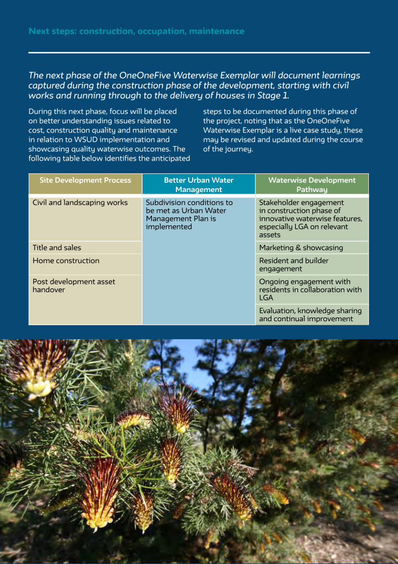
PAGE 28
Next steps: construction, occupation, maintenance
The next phase of the OneOneFive Waterwise Exemplar will document learnings captured during the construction phase of the development, starting with civil works and running through to the delivery of houses in Stage 1.
During this next phase, focus will be placed on better understanding issues related to cost, construction quality and maintenance in relation to WSUD implementation and showcasing quality waterwise outcomes. The following table below identifies the anticipated
steps to be documented during this phase of the project, noting that as the OneOneFive Waterwise Exemplar is a live case study, these may be revised and updated during the course of the journey.
Site Development Process Better Urban Water Management
Waterwise Development Pathway
Civil and landscaping works Subdivision conditions to be met as Urban Water Management Plan is implemented
Stakeholder engagement in construction phase of innovative waterwise features, especially LGA on relevant assets
Title and sales Marketing & showcasing
Home construction Resident and builder engagement
Post development asset handover
Ongoing engagement with residents in collaboration with LGA
Evaluation, knowledge sharing and continual improvement

PAGE 29
References
Bickman, L. and Rog, D.J. (1998) Handbook of Applied Social Research Methods. Sage Publications.
Byrne, J., Green, M., and Dallas, S. (2018) WSUD Implementation in a Precinct Residential Development: Perth Case Study. Chapter 26 in Sharma, A., Gardner, T. and Begbie, D. (eds) Approaches to Water Sensitive Urban Design 1st Edition.
Byrne, J.J., (2016) Mains Water Neutral Gardening: An integrated approach to water conservation in sustainable urban gardens. Doctoral Thesis. Murdoch University, Murdoch, Western Australia.
Catchlove, R (2020) Constructing business cases for water sensitive investments: a handbook for local government Melbourne, Australia: Cooperative Research Centre for Water Sensitive Cities
Choi, L and McIlrath, B (2017) Policy Framework for Water Sensitive Urban Design in 5 Australian Cities. Melbourne, Australia: Cooperative Research Centre for Water Sensitive Cities.
Department of Planning and Local Government SA (2010) Water Sensitive Urban Design Technical Manual for the Greater Adelaide Region, Government of South Australia, Adelaide
Department of Water (2013) Guideline for the approval of non-drinking water systems in Western Australia: Urban developments.
Department of Water and Environmental Regulation (2019) Waterwise Perth Action Plan.
Department of Water (2004-2007) Stormwater Management Manual for Western Australia, Department of Water, Perth. Available www.dwer.wa.gov.au.
Department of Water and Environmental Regulation (2017) Decision process for stormwater management in Western Australia, Department of Water and Environmental Regulation, Perth. Available www.dwer.wa.gov.au.
Furlong, C., Gan, K. and De Silva, S. (2016) Governance of Integrated Urban Water Management in Melbourne, Australia. Utilities Policy, 43, 48-58.
Government of Western Australia (2003) State Water Strategy, Department of the Premier and Cabinet, Perth, Western Australia.
Government of Western Australia (2007) State Water Plan, Department of the Premier and Cabinet, Perth, Western Australia.
Henderson, C., Kinch, J., and Newell, B. (2015) Passive watering of landscapes for stormwater treatment: Design and modelling guidelines [online]. In: 9th International Water Sensitive Urban Design (WSUD 2015). Barton, ACT: Engineers Australia, 2015: 212-222. Availability: <https://search-informit-com-au.dbgw.lis.curtin.edu.au/documentSummary;dn=730882427552965;res=IELENG> ISBN: 9781922107671. [cited 04/06/ 20].
Johnstone, P., Adamowicz, R., de Haan, F.J., Ferguson, B., Wong, T. (2012) Liveability and the Water Sensitive City - Science-Policy Partnership for Water Sensitive Cities. Melbourne, Australia: Cooperative Research Centre for Water Sensitive Cities, ISBN 978-1-921912-17-7
Josh Byrne & Associates (2020) Local Water Management Strategy: Hamilton Senior High School Redevelopment. Prepared for DevelopmentWA
Josh Byrne & Associates (2018) Landscape Master Plan Report: Hamilton Senior High School Redevelopment.
Josh Byrne & Associates (2017a) Water Strategy - Hamilton Senior High School Redevelopment. Prepared for LandCorp (now DevelopmentWA) and Water Corporation.
Josh Byrne & Associates (2017b) Energy Strategy - Hamilton Senior High School Redevelopment.
https://search-informit-com-au.dbgw.lis.curtin.edu.au/documentSummary;dn=730882427552965;res=IELENG>

PAGE 30
Prepared for LandCorp (now DevelopmentWA).
Keremane, G., McKay, J. and Wu, Z. (2017) Urban Water Governance for the Twenty-First Century: A portfolio-based approach to planning and management (chapter 6) in Freshwater Governance for the 12st Century, Global Issues in Water Policy 6, DOI 10.1007/978-3-319-43350-9_6.
Lehmann, S. (2010) Green Urbanism: Formulating a Series of Holistic Principles, S.A.P.I.EN.S [Online], 3(2), Online since 12 October 2010. URL: http://sapiens.revues.org/1057
Leonard, R., Iftekhar, S., Green, M. and Walton, A. (2018) Community Perceptions of the Implementation and Adoption of WSUD Approaches for Stormwater Management. Chapter 24 in Sharma, A., Gardner, T. and Begbie, D. (eds) Approaches to Water Sensitive Urban Design 1st Edition.
Lloyd and Buck (2018) Water Sensitive Cities Benchmarking and Assessment: City of Cockburn Council Area, Australia: Cooperative Research Centre for Water Sensitive Cities, March.
Maheepala, S., Blackmore, J., Diaper, C., Moglia, M., Sharma, A., and Kenway, S. (2010) Integrated Urban Water Management Planning Manual. Water Research Foundation and CSIRO.
Marlow, D. R., Moglia, M., Cook, S., Beale, D. J., (2013) Towards sustainable urban water management: A critical reassessment. Water Res, 47(20), 7150-7161. doi: 10.1016/j.watres.2013.07.046
Melbourne Water (2013) Water Sensitive Urban Design Guidelines: South Eastern Councils.
Mitchell, V. (2006) Applying Integrated Urban Water Management Concepts: A review of Australian experience. Environmental Management. 37. 589-605. 10.1007/s00267-004-0252-1.
Pantone (2020) Pantone 19-4052 Classic Blue https://www.pantone.com/color-intelligence/color-of-the-year/color-of-the-year-2020 (accessed 4/6/20).
Payne, E.G.I., Hatt, B.E., Deletic, A., Dobbie, M.F., McCarthy, D.T. and Chandrasena, G.I. (2015) Adoption Guidelines for Stormwater Biofiltration Systems, Melbourne, Australia: Cooperative Research Centre for Water Sensitive Cities.
Sharma, A., Rashetnia, S., Gardner, T. and Begbie, D. (2018) WSUD Design Guidelines and Data Needs. Chapter 4 in Sharma, A., Gardner, T. and Begbie, D. (eds) Approaches to Water Sensitive Urban Design 1st Edition.
Sharma, A. et al. (2016) Water Sensitive Urban Design: An Investigation of Current Systems, Implementation Drivers, Community Perceptions and Potential to Supplement Urban Water Services. Water, 8, 272.
Sharma, A., Cook, S., Tjandraatmadja, G. & Gregory, A. (2012) Impediments and constraints in the uptake of water sensitive urban design measures in greenfield and infill developments. Water Science and Technology, 65, 340-352.
South Australian Department of Planning and Local Government (2010) Water Sensitive Urban Design Technical Manual for the Greater Adelaide Region, Government of South Australia, Adelaide https://www.sa.gov.au/topics/planning-and-property/land-and-property-development/planning-professionals/water-sensitive-urban-design
Terra Rosa (2017) Report on an Aboriginal Heritage Survey and Consultation with Whadjuk Traditional Owners of the proposed Hamilton Senior High School re-development, for LandCorp.
https://www.pantone.com/color-intelligence/color-of-the-year/color-of-the-year-2020 (accessed 4/6/20

PAGE 31
Tjandraatmadja, G. (2018) The Role of Policy and Regulation in WSUD Implementation. Chapter 5 in Sharma, A., Gardner, T. and Begbie, D. (eds) Approaches to Water Sensitive Urban Design 1st Edition.
Water Corporation (2020) https://www.watercorporation.com.au/Help-and-advice/Waterwise-business-programs/Waterwise-Council-Program/Endorsed-Waterwise-Councils
Water Corporation (2019) The West Australian Greywater Guide: A source of practical information on how to best reuse domestic greywater in Western Australia. Prepared by Josh Byrne & Associates (JBA) and the Greywater and Wastewater Industry Group Inc. (GWIG) for Water Corporation.
Water Corporation (2018) Community Bore Guide: Information for implementing community bore schemes in residential developments in Western Australia. Prepared by Josh Byrne & Associates (JBA) for Water Corporation.
Water Sensitive Transition Network (2019) Vision and Transition Strategy for a Water Sensitive Greater Perth – Implementation Plan 2019-2021. Melbourne, Australia: Cooperative Research Centre for Water Sensitive Cities.
Walsh, C.J. et al. (2015) Principles for urban stormwater management to protect stream ecosystems. Freshwater Science. 35(1), 398-411.
Western Australian Planning Commission (2008) Better Urban Water Management.
Western Australian Planning Commission (2007) Liveable Neighbourhoods: a Western Australian Government sustainable cities initiative, Western Australian Planning Commission, Perth, Western Australia
Western Australian Planning Commission (2006) Water Resources Statement of Planning Policy 2.9.
Western Australian Planning Commission (1997) State Planning Strategy, Western Australian Planning Commission, Perth, Western Australia
Wong, T., Brown, R. (2008) Transitioning to water sensitive cities: Ensuring Resilience through a new Hydro-Social Contract, 11th International Conference on Urban Drainage, Edinburgh, Scotland, UK. 1–10.
- End of Document -
PAGE 32
Appendix
APPENDIX 1 Waterwise Development Site Process
APPENDIX 2 Permeable Paving Fact Sheet
APPENDIX 3 Water Harvesting Tree Pits Fact Sheet
APPENDIX 4 Roadside Bio-filtration Swales Fact Sheet
APPENDIX 5 Underground Stormwater Retention Systems Fact Sheet
APPENDIX 6 Community Groundwater Bore Case Study

This page has been left blank intentionally

APPENDIX 1 - Waterwise Development Site Process

This page has been left blank intentionally

Planning, design and approvalsConstruction, occupation
and maintenance
Project definition, visioning & appointment of consultants
Urban water and hydrologist expertise required on the project team supported by a multidisciplinary project team (planner, civil engineer and landscape architect)
Establish waterwise aspirations• Waterwise and sustainability aspirations
identified in the consultant’s brief
Concept planning • Site and context analysis; constraints and
opportunities• Identification of environmental assets• Identification of strategic drivers• Develop sustainability objectives• Community and stakeholder consultation
Local Water Management Strategy (LWMS)• Groundwater quality and level monitoring• Surface water quality and quantity (volumes,
flow rates and flood level) monitoring• Water balance• Hydrological modelling• Infrastructure needs• Confirmation of potable, non-potable and
wastewater servicing arrangeents • Management of water/environmental assets and
enhancement opportunities • Specific management practices for stormwater• Conceptual landscape outcomes
Project visioning and identification of waterwise goals (entire project team)
LGA strategic direction and accreditation• Cross check LGA Waterwise Council status,
Water Sensitive City Benchmarking and other strategic urban greening/liveability programs
Establish stakeholder working group to inform and support waterwise initiatives
Liaise with DWER regarding alternative water supply options(e.g. recycled water scheme or community bore) and undertake business case
Master Plan• Decide suitable sustainability framework • Landscape Master Plan• Community and stakeholder engagement
Develop a Waterwise Strategy for the project:• Align w/ project team• Brief stakeholders (inc LGA)
Local Structure Plan & technical reports• Establish land use, density and public open
space (Landscape Master Plan)• Environmental features and protection • Movement network• Engineering and environmental requirements • Local Water Management Strategy• Community and economic development
Engage stakeholders on innovative waterwise initiatives
Design responses to suit site specific requirements
Subdivision Plan • Detailed civil and landscape design• Local development plan• Residential Design Guidelines
Urban Water Management Plan (UWMP)• Further detailed modelling • Final design and siting for water management
infrastructure• Implementation plan for agreed environmental,
water and landscape outcomes• Management of construction works
Stakeholder input into waterwise details, particularly LGA
Waterwise program alignment with Design Guidelines
Sustainability program certification
Waterwise Development certification
Civil and landscaping works Subdivision conditions to be met as Urban Water Management Plan is implemented
Stakeholder engagement in construction phase of innovative waterwise features, especially LGA on relevant assets
Title and sales Marketing & showcasing
Home construction Resident and builder engagement
Post development asset handover Ongoing engagement with residents in collaboration with LGA
Evaluation, knowledge sharing and continual improvement
Wat
erw
ise
Dev
elop
men
t Pat
hway
Bet
ter U
rban
Wat
er M
anag
emen
t
Site
Dev
elop
men
t Pro
cess
Waterwise Development Site Process

This page has been left blank intentionally

APPENDIX 2 - Permeable Paving Fact Sheet

This page has been left blank intentionally

OneOneFive by DevelopmentWA is a residential infill development located on the former Hamilton Senior High School Site in the City of Cockburn. The project is a ‘waterwise exemplar’ through the application of Water Sensitive Urban Design (WSUD) principles and waterwise practices, including localised stormwater management to support landscape plantings and contribute to urban cooling.
This fact sheet documents the permeable paving treatment being installed into Stage 1 of the project, as approved under the Subdivision Plan and accompanying Urban Water Management Plan (UWMP).
Permeable paving at OneOneFive Hamilton Hill

What is permeable paving?
Permeable paving is a load bearing pavement structure that allows water to infiltrate into the soil below to provide an ‘at-source’ stormwater control. It is best suited to low traffic roads, car parks, driveways and pedestrian areas. There are four main types of paving used:
Porous asphalt Similar to conventional asphalt except fines are removed to create greater void space and additional binders are used to provide greater durability and prevent breakdown.
Pervious concreteFines in the mix are reduced to maintain interconnected void space, resulting in a coarser appearance than standard concrete.
Grid pavement systems (plastic or concrete)Modular grids filled with turf and/or gravel that allow infiltration through the surface.
Permeable modular interlocking pavementDrainage through aggregate-filled gaps between pavers (the pavers themselves are not permeable).
Benefits
Urban areas consist of large amounts of impervious surfaces, such as roads, driveways and parking bays. Extensive paved areas affect the water cycle by increasing the volume of water runoff during peak events. This impacts downstream flooding and requires increased drainage infrastructure.
Using permeable paving can provide benefits such as:
• Reduced stormwater runoff volumes.• Reduced or eliminated pipe and pit costs.• Localised wetting of soil to aid landscape plant growth.• Increase urban cooling, through plants transpiring and soil moisture evaporating into the
atmosphere.• Increased groundwater recharge via infiltration of subsoil.• Improved stormwater quality, which prevents transfer of pollutants to other areas.• Increased landscape aesthetics.

Site suitability for permeable paving (structure plan and local water management strategy (LWMS) stage – concept landscape and engineering design)
Proposed as a part of the integrated WSUD approach to managing stormwater on site, the project team assessed options for including permeable paving to capture and infiltrate small rain events where they fall. Original design concepts considered the implementation of permeable paving at all driveway cross-overs and car bays, as well as flat sections of road. This concept evolved through the structure planning and subdivision design process.
Engagement with LGA and leading experts (structure plan and LWMS stage)
The project team undertook a workshop with City of Cockburn staff who represented planning, engineering, parks and environment departments. The workshop discussed the benefits, design and typical inspection and maintenance activities for permeable paving, as well as other at-source stormwater control options that were being considered for the project.
The project team liaised with the City of Belmont to understand their previous implementation experience with permeable paving (in parking areas). In addition, members of the project team connected with researchers and practitioners in Adelaide to better understand experiences with different products, including the management of issues such as clogging and weed management. A permeable modular interlocking pavement product was selected based on demonstrated success.
Refinement of WSUD stormwater controls (subdivision design and UWMP stage – detailed landscape and engineering design)
The range of localised stormwater control typologies was refined during design development and overall a more conservative approach was adopted for Stage 1 of the development based on feedback from the City of Cockburn. The use of permeable paving (as well as water harvesting tree pits and roadside bio-filtration swales) was to be limited to the most practical and high impact areas, with learnings to be factored into the potential expansion of their use in subsequent development stages.
OneOneFive Hamilton Hill Case Study
Planning, design and approval for permeable paving
Permeable paving

Detailed design (finalisation of subdivision plans and UWMP)
The project team addressed the City’s requirements while not compromising the WSUD and sustainability vision for the project. During these initial discussions the City’s preference was for permeable paving only in car bays for ease of maintenance and repair, however the project team highlighted the importance of including permeable paving on suitable (flat) road areas as a WSUD demonstration initiative that would be a first for Perth. In addition, the City agreed to use permeable paving for all on-street car bays and in three proposed road areas, with the clause that any failure will be reinstated by the developer before asset handover.
LegendPermeable paversSemi-mountable kerbLandscape soil30mm thick bedding (2-5mm aggregate)
Geogrid and Geotextile 300mm thick permeable base (10mm-40mm aggregate)Compacted sub-grade250mm compacted road base
1
2
3
4
5
6
7
8
1
Interlocking paversAggregate-filled gaps (drainage)
300M
M
FALL
2 3
54
6
Permeable paving - Section
7
8
FALL
1
Cost estimate for installation at design stage
Opinion of Probable Cost (OPC): $151/m2. This includes:• Midland Brick Aqua Tri-Pave 80mm.
• 2-5mm aggregate in all paver voids.
• 30mm bedding aggregate (2-5mm aggregate).
• Supply, lay, trim and compact aggregate permeable base (10-40mm) fully wrapped in geofabric, utilising crushed concrete and brick road base from existing stockpiles on site (300mm).
*Note: additional fact sheet information on permeable paving will be provided as OneOneFive Hamilton Hill moves into construction and operational phases, including costs and maintenance requirements.

APPENDIX 3 - Water Harvesting Tree Pits Fact Sheet

This page has been left blank intentionally

OneOneFive by DevelopmentWA is a residential infill development located on the former Hamilton Senior High School Site in the City of Cockburn. The project is a ‘waterwise exemplar’ through the application of Water Sensitive Urban Design (WSUD) principles and waterwise practices, including localised stormwater management to support landscape plantings and contribute to urban cooling.This fact sheet documents the water harvesting tree pits being installed into Stage 1 of the project, as approved under the Subdivision Plan and accompanying Urban Water Management Plan (UWMP).
Water harvesting tree pits at OneOneFive Hamilton Hill

What is a water harvesting tree pit?
The term tree pit (or tree well) refers to the location and ‘hard landscaping’ arrangement that trees are planted into within paved areas. Tree pits can be designed in a way where they can contribute to ‘at-source’ stormwater control by receiving runoff from adjacent surfaces. These are referred to as ‘water harvesting’ tree pits. They can also act as ‘bio-filters’ to improve stormwater quality, through considered use of planting media and root zone drainage, however this function is normally limited to situations where stormwater quality management is a specific issue.
Benefits
Built-up urban areas can be hostile environments for establishing trees. Root zone space is often limited due to space constraints from paving and services, such as cables and pipes. Radiant heat from paving and roads can also lead to moisture stress. A major benefit of integrating tree pits with stormwater drainage, is the additional water they receive supports healthy growth and reduces reliance on irrigation.
Other benefits include: • Additional moisture provided to trees increases evapotranspiration which aids urban cooling.• When water harvesting tree pits include good quality structural soils with adequate pore
space, they can contribute to local stormwater retention and infiltration. This takes pressure off downstream stormwater drainage infrastructure required in public open spce (POS) and it enhances usability.
• If required, water harvesting tree pits can be designed to act as biofilters that assist with water quality improvement.

Site suitability for water harvesting tree pits (structure plan and Local Water Management Strategy (LWMS) stage – concept landscape and engineering design)
The design for OneOneFive is targeting a 30% tree canopy across the development which includes the planting of 350 new trees in public areas such as streetscapes. The high depth to groundwater at the site means that trees will be highly dependent on irrigation for establishment. The use of water harvesting tree pits was identified as a way to reduce ongoing irrigation requirement through passive watering.
Engagement with LGA (structure plan and LWMS stage)
The use of water harvesting tree pits was discussed at a workshop involving City of Cockburn officers that represent the planning, engineering, parks and environment departments. Importantly, the connection between the use of water harvesting tree pits and the performance of new tree plantings in relation to meeting the tree canopy target was made. Various pit designs were discussed utilising valuable experience from both the project team and City officers. It was also acknowledged that the contribution of the pits to the reduction to overall stormwater flows would be relatively minor, and their main purpose was to aid in the establishment of healthy trees and reduce ongoing irrigation requirements. Tree pits would not be designed as bio-filters given that stormwater quality was not a specific issue at this site, although their inclusion would contribute to better stormwater quality and reduced stormwater flows by capturing some first flush events.
Refinement of WSUD stormwater controls (subdivision design and UWMP stage – detailed landscape and engineering design)
The number and location of water harvesting tree pits was refined in line with the progress of civil engineering and landscape design. Further refinement of pit design was undertaken by the project team using previous experience of both successes and failures. Additional research of designs implemented on other projects around Australia was also considered, noting that the eventual design would need to be suitable for the relatively unique sandy soil conditions of OneOneFive (and other areas of Perth).
OneOneFive Hamilton Hill Case Study
Planning, design and approval for water harvesting tree pits
Water harvesting tree pit

Detailed design (finalisation of subdivision plans and UWMP)
Detailed design of the pits was finalised by the project team, with a review undertaken by City of Cockburn officers as part of the Stage 1 engineering design and UWMP submission. Key considerations at this stage include:
• Ensuring trees have adequate irrigation for establishment (and maintenance) watering in the event that stormwater harvesting volumes are inadequate.
• Ensuring that the edges of the tree pits are stabilised to prevent subsidence and scouring. • Elimination of trip hazards by attention to final levels between surrounding paving and top of pit soil level. • Use of non-floating mulch, or other means of mulch stabilisation, to prevent mulch washing away in
heavy storm events.
Water harvesting tree pit - Section
LegendRoad pavementFlush kerb with notched openingTransition kerbStone mulch channel Planting media (with bio-filtration media if required) Adjacent finish to sit 100mm above tree pit soil
1
2
3
4
5
6
Water harvesting tree pit - Plan1
22
5
44
Section
FLO
W IN
FLO
W IN
33
2500
MM
3300MM
150MM
12
5
64
3
Note: This section is a typical representation and variation may occur due to nature of tree & site.
100MM
Cost estimate for installation at design stageTree pit Opinion of Probable Cost (OPC): $1,500m2. This includes:
• Over-excavation of tree pits / rain gardens.• Bio-retention media including stone mulch, sandy loam, well graded sand and drainage layer.• Kerbing and verge shape modifications.• Tree and shrub planting and stone boulders.
*Note: additional fact sheet information on water harvesting tree pits will be provided as OneOneFive Hamilton Hill moves into construction and operational phases, including costs and maintenance requirements.

APPENDIX 4 - Roadside Bio-filtration Swales Fact Sheet

This page has been left blank intentionally
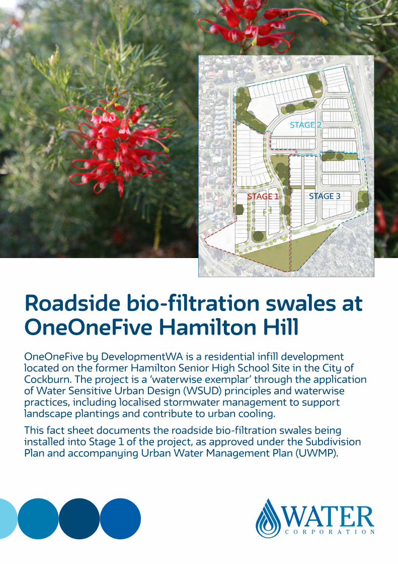
OneOneFive by DevelopmentWA is a residential infill development located on the former Hamilton Senior High School Site in the City of Cockburn. The project is a ‘waterwise exemplar’ through the application of Water Sensitive Urban Design (WSUD) principles and waterwise practices, including localised stormwater management to support landscape plantings and contribute to urban cooling. This fact sheet documents the roadside bio-filtration swales being installed into Stage 1 of the project, as approved under the Subdivision Plan and accompanying Urban Water Management Plan (UWMP).
Roadside bio-filtration swales at OneOneFive Hamilton Hill

What is a roadside bio-filtration swale?
Swales are grassed or vegetated channels used to collect stormwater so it can infiltrate into the ground. Bio-filtration swales comprise a channel with vegetation and layers of filter material comprised of soils of differing particle size and nutrient retention ability to improve stormwater quality, as well as slowing and reducing runoff. Swales can be used in median strips, road verges, within allotment landscaping and in parklands and are best suited for slopes between 2% and 5%.
Benefits
Swales are a cost-effective way of dealing with stormwater by enabling local infiltration and reducing peak volume impacts on downstream drainage infrastructure. Depending on their design, swales can also be used to treat stormwater by removing nutrients and other contaminants. Swales are a good way to harvest water off roads and paving where it can be directed to plants, reducing the need for irrigation and helping with urban cooling. This is the main reason they are being used at OneOneFive.
Other benefits of roadside swales include:
• Lower capital costs than conventional piped systems.• Dense plantings can help with removal of pollutants including sediments, nutrients,
hydrocarbons and heavy metals, particularly during first flush events.• Swales vegetated with native plants increase biodiversity and habitat.• Reduced need for stormwater pipes and drainage infrastructure in public open space (POS)
which enhances useability and reduces maintenance and asset replacement costs for local government.

Site suitability for roadside bio-filtration swales (structure plan and local water management strategy (LWMS) stage – concept landscape and engineering design)
The project team proposed that vegetated swales should be integrated with kerb-side drainage where possible throughout the site. Configuration needed to consider car bays, service alignment, road widths, pedestrian movement and safety, and overall slope and urban design intent. Across the site, the greatest opportunity for roadside swales is where roads are adjacent to POS/green areas.
Engagement with LGA (structure plan and LWMS stage)
The OneOneFive project team presented water sensitive urban design swale concepts to the City of Cockburn, where concerns were raised over the level of service required to maintain POS and streetscapes with swales, with these concerns being taken into the next stage of design. The project team also liaised with Department of Water and Environmental Regulation (DWER) officers to discuss their concerns over the lack of median vegetated swales for treatment and conveyance function. It was identified that the road reserve widths do not facilitate median swales. Once the greater urban design vision for the project was explained, along with the local site context that was guiding the application of WSUD, the DWER officers were confident with the project team’s approach.
Refinement of WSUD stormwater controls (subdivision design and UWMP stage – detailed landscape and engineering design)
Swale design and location were further scoped, responding to site circumstances and City of Cockburn requirements, including:
• Recognising that there was often limited room in verges for swales in a number of streets due to driveways, footpaths and car bays.
• The City’s preference for fewer and larger swales located closer together for ease of maintenance.
• The City’s concerns regarding flush kerbs next to POS areas needing adequate stabilisation to avoid potential erosion.
OneOneFive Hamilton Hill Case Study
Planning, design and approval for roadside bio-filtration swales
Roadside swales

*Note: Swale dimensions will vary depending on topographical features, such as verge width or slope.
Cost estimate for installation at design stage
OneOneFive swale Opinion of Probable Cost (OPC)=$21,500* each. This includes:
• Over-excavation of bio-retention swale.• Planting and stone boulders.• Bio-retention media including stone mulch, sandy loam, well graded sand and drainage
layer.• Kerbing and verge shape modifications.
* OPC based on a swale designed with the features shown in the plan above, measuring 4.5m wide and 17.3m long.
**Note: additional fact sheet information on roadside bio-filtration swales will be provided as OneOneFive Hamilton Hill moves into construction and operational phases, including costs and maintenance requirements.
Detailed design (finalisation of subdivision plans and UWMP)
To assist with successful ongoing performance of swales, the City requested that DevelopmentWA ensure swales are functioning, with vegetation in good condition at the time of handover following a two-year consolidation period and commit to resolving any defects.
Section 3
5
LegendRoad pavementFlush kerb with notched openingBarrier kerbBio-filter media (as required)
Rock pitched channelRock pitched weirGrated inlet pit1 EY event
1
2
3
4
5
6
7
8
12
4
8
Section 2Section 16
5
Roadside bio-filtration swale - Plan
12 27
8
Section 1 Section 2 Section 3
6
4
5 5
3 3 3
6

APPENDIX 5 - Underground Stormwater Retention Systems Fact Sheet

This page has been left blank intentionally

OneOneFive by DevelopmentWA is a residential infill development located on the former Hamilton Senior High School Site in the City of Cockburn. The project is a ‘waterwise exemplar’ through the application of Water Sensitive Urban Design (WSUD) principles and waterwise practices, including localised stormwater management to support landscape plantings and contribute to urban cooling.
This fact sheet documents the underground stormwater retention systems being installed into Stage 1 of the project, as approved under the Subdivision Plan and accompanying Urban Water Management Plan (UWMP).
Underground stormwater retention systems at OneOneFive Hamilton Hill

What are underground stormwater retention systems?
Underground stormwater retention systems help to store and infiltrate stormwater runoff, as well as provide treatment via the removal of gross pollutants. They can be used to supplement or substitute above ground retention basins and can accommodate a range of storm events depending on sizing.
Benefits
Even with the use of ‘at-source’ stormwater control methods like permeable paving, tree pits and roadside bio-filtration swales, additional measures are required to deal with stormwater from heavy rainfall events. It is typically a requirement of development approval that stormwater be managed within the development site or maintained to pre-development runoff rates, frequencies and volumes. A common approach to achieving this is to use above ground retention basins located in public open space (POS). Where space is limited, or where creating basins might impact existing trees, underground retention chambers are a good option. They can also be installed under roads, parking bays and landscaped verges making them very space efficient.
Other benefits include:
• Useful in areas where above ground retention basins are not practical or desirable.• Installation under roads avoids conflict with desire to retain mature trees and means that
natural areas of a site can remain undisturbed.• Temporary storage of runoff, with release into the environment through infiltration into the soil.• When located around a site, they distribute stormwater and make it available to deep rooted
vegetation.• Optimisation of POS for recreation and conservation.
Contents
WSUD and stormwater detention 2
The water cycle and urban development 2
On-site detention and infiltration -
the way forward
3
StormTrap® system - a complete solution 4
System operation 7
SingleTrap™ system 7
DoubleTrap™ system 7
Key specifications 8
Vehicular/machinery loading 9
Cover 9
Access openings 9
Geotechnical considerations 9
Australian standards 9
Design and installation 10
1. Preliminary design 10
2. Final design/approval drawings 10
3. Logistics, shipping and installation 10
Soakwells 11
Appendix 1 – StormTrap® system - preliminary
bid/design request
12
Contact information 13
> WA Schools PPP Case Study – Continued.
Find your solution todayGEOFABRICS.CO
Sediment Removal A designated Catch-All-Row, is designed to capture and remove sediment.
Infiltration A large ecoAID stormwater collection tank used for infiltration.
Ready for Cover ecoAID has been assessed under AS 5100.2 Australian Bridge Design Wheel Loads, which means after cover (as per our installation guidelines) the system is trafficable.
Being a government driven project there was a large emphasis placed on the consortium to source locally manufactured products and systems wherever possible. ecoAID was the natural choice as it has been designed, manufactured and structurally tested in Australia. Local manufacture not only provides a financial boost to the Australian economy, it also provides shorter lead times to site and significantly reduces the carbon footprint when compared with imported products.
Geofabrics provided continual support and assistance to the consortium’s design team and to the sub-contractors installing the ecoAID chambers on site.
The main benefits of ecoAID are:
• Australian made – reducing carbon footprint, reducing lead times and boosting the local manufacturing economy.
• Serviceable due to unimpeded access for cleaning.
• Extended maintenance return intervals.
• Extremely strong and has been assessed to AS 5100.2 Australian Bridge Design Wheel Loads.
• Each arch weighs 15 kg – Can be handled and put into place by one person ensuring safe and rapid installation.
• The arch chamber is made from Virgin Polypropylene ensuring the system meets its 100 year design life expectancy.
• Has been designed, manufactured and tested to ASTM F2787 (Structural Design of Thermoplastic Corrugated Wall Stormwater Collection Chambers).
• Cost effective – typically the lowest costing stormwater system currently on market.

Site suitability for underground stormwater retention (structure plan and local water management strategy (LWMS) stage – concept landscape and engineering design)
The free draining soils and large depth to groundwater at OneOneFive make the site well suited to localised stormwater infiltration. Initially a combination of cost effective above ground basins and site responsive underground retention was considered.
Engagement with LGA (structure plan and LWMS stage)
There are a number of underground retention systems available on the market. City of Cockburn engineering officers indicated their preference to use StormTrap during preliminary stormwater engineering design discussions as they have experience with the application of this product.
After further design work during structure planning and development of the LWMS, the project team decided to preference underground stormwater retention over above ground basins due to the sloping nature of the site and to avoid impacting the root zones of existing trees. It was decided that above ground basins would not be used in the southern bushland area of the site (despite available space) as it would create artificial wetting patterns and increase the likelihood of invasive weeds.
Refinement of WSUD stormwater controls (subdivision design and UWMP stage – detailed landscape and engineering design)
Three underground retention products were investigated, including ecoAID, TunnelWell and StormTrap. The project team suggested ecoAID be used throughout the site, including under roads, as it has a lowest cost, the lowest embodied carbon value and requires the use of drainage aggregate available in plentiful supply on site in the form of screened crushed recycled concrete and bricks from the demolition of the old Hamilton Senior High School buildings. The project team also had successful prior experience with ecoAID in similar applications on other projects.
Detailed design (finalisation of subdivision plans and UWMP)
City of Cockburn engineering officers would only accept the use of the StormTrap product under roads, with access chambers located within verges to allow maintenance without obstructing vehicle movements. The southern end of Purvis Street was an exception, with the Tunnelwell product approved due to low traffic movement. Elsewhere, the ecoAID product will be used where it will be installed in verge areas. This was seen as a reasonable compromise by the project team, especially as the majority of required retention volume will be achieved through the use of the ecoAID product.
OneOneFive Hamilton Hill Case Study
Planning, design and approval for roadside swales
Stormwater retention system

Underground retention system - Section (ecoAID example)
1
2
345
LegendCompacted backfill 19-50mm washed crushed demolition aggregateecoAID EC-1000 drainage cells300mm ø drainage pipe
Bubble up pit to 300mm ø stormwater overflow drainage pipe19-50mm crushed demolition aggregateSand baffleAir vent to valve box
1
2
3
4
5
6
7
8
8
7
6
600M
M
300MM
300MM
300MM
680MM
Options and costs estimates at design finalisation
ecoAID Tunnelwell StormtrapManufacturer Geofabrics Sentry Holdings Pty Ltd Humes (Holcim)
Manufactured in Australia WA Australia
Material Polypropylene Polyethylene Reinforced concrete
Amount of recycled aggregate used per m3 of stormwater management volume
1.56 1.28** 0.31
Total footprint (kg CO2e/m3
stormwater management volume)
60 148 170 / 476*
Cost per cubic metre $380 $420 $750
*The calculations assume that StormTrap uses the same ‘eco-mix’ (reduced CO2) concrete that Humes reinforced concrete piping is made from. If not, and if the Australian average for concrete carbon intensity is used, then the overall carbon intensity of the product increases to 476 kg CO2e / m3 stormwater management volume.
**The calculations assume that Tunnelwell can be backfilled with aggregate, and that the excavated material can be used onsite. The same assumption about reuse onsite of excavated material applies to EcoAid.
ReferencesGeofabrics (2020) ecoAid: Stormwater Management Chambers www.geofabrics.co/products/ecoaid-0 (Accessed 30/6/2020).StormTrap (2020) StormTrap modular concrete stormwater management www.stormtrap.com (Accessed 30/6/2020).TunnelWell (2020) TunnelWell simplicity for stormwater. www.tunnelwell.com (Accessed 30/6/2020)*Note: additional fact sheet information on underground retention will be provided as OneOneFive Hamilton Hill moves into construction and operational phases, including costs and maintenance requirements.

APPENDIX 6 - Community Groundwater Bore Case Study

This page has been left blank intentionally

Business case & preliminary designOneOneFive Hamilton Hill by DevelopmentWA is a residential infill development located on the former Hamilton Senior High School site in the City of Cockburn. The project is a ‘waterwise exemplar’ through the application of Water Sensitive Urban Design (WSUD) principles and waterwise practices.
A community groundwater bore scheme is proposed for the development as part of a suite of waterwise initiatives, using locally available groundwater in a sustainable way for the irrigation of public and private gardens.
This Case Study documents the process of determining the suitability of a community groundwater bore scheme for the development as guided by the Water Corporation Community Bore Guide (JBA, 2018).
OneOneFive Hamilton Hill community groundwater bore case study

2
•
What is a community groundwater bore?
A community groundwater bore supplies groundwater via a reticulated network in a residential development for irrigation of both public realm green space and private gardens.
Benefits
Community groundwater bores can provide a sustainable water supply for both public and private irrigation if implemented in a location with available groundwater and as part of a suite of integrated urban water management options and water efficiency measures that reduce overall water use.
Benefits of community groundwater bores include:• Potential to provide a well-managed, fit-for-purpose
alternative non-drinking water supply. • Maintain or increase urban greening and improve local
amenity.• Maximised water efficiency if implemented with waterwise
approaches such as water metering, efficient irrigation systems and waterwise landscape design.
• Reduced energy intensity and carbon emissions compared with mains water supply.
• Replace the need for individual household bores.
Water Corporation Community Bore GuideThe Water Corporation Community Bore Guide was developed to provide information for land developers, local governments or other service providers on the planning, technical, operational and governance aspects of community bores. It ensures that community bores are designed, implemented and managed to suit site specific conditions and prevent overuse of Perth’s precious groundwater. It contains two sections:1. A Community Bore ChecklistThe Checklist provides an introduction to community bores and a suggested four stage process to assist in site specific implementation. Stages include:
2. Community Bore Report The report contains additional detail on the suggested four stage process, as well as a ‘Concept to Operation’ flowchart, a developer to service provider handover procedure, insights into stakeholder experiences from previous community bore implementation and examples that support the process of implementation.
A report on how to implement community bore schemes in residential developments in Western Australia.
Part 2 COMMUNITY BORE
Report
Department of Water and Environmental Regulation
PAGE I
A checklist to assist with implementing community bore schemes in residential developments in Western Australia.
Part 1COMMUNITY BORE
CHECKLIST
Department of Water and Environmental Regulation
PAGE I
Information for implementing community bore schemes in residential developments in Western Australia.
COMMUNITY BOREGuide
Department of Water and Environmental Regulation
1. Planning
3. Installing & Commissioning
2. Designing
4. Operating & Maintaining
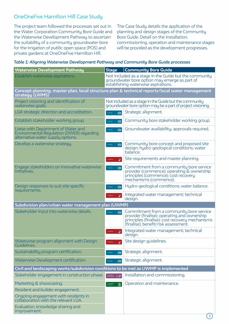
3
Waterwise Development Pathway Stage Community Bore GuideEstablish waterwise aspirations. Not included as a stage in the Guide but the community
groundwater bore option may emerge as part of establishing waterwise aspirations.
Concept planning, master plan, local structure plan & technical reports/local water management strategy (LWMS)Project visioning and identification of waterwise goals.
Not included as a stage in the Guide but the community groundwater bore option may be a part of project visioning.
LGA strategic direction and accreditation. 1. Planning Strategic alignment.
Establish stakeholder working group. 1. Planning Community bore stakeholder working group.
Liaise with Department of Water and Environmental Regulation (DWER) regarding alternative water supply options.
1. Planning Groundwater availability; approvals required.
Develop a waterwise strategy. 1. Planning Community bore concept and proposed site design; hydro-geological conditions; water balance.
2. Designing Site requirements and master planning.
Engage stakeholders on innovative waterwise initiatives.
1. Planning Commitment from a community bore service provider (commence); operating & ownership principles (commence); cost recovery mechanisms (commence).
Design responses to suit site specific requirements.
1. Planning Hydro-geological conditions; water balance.
2. Designing Integrated water management; technical design.
Subdivision plan/urban water management plan (UWMP)Stakeholder input into waterwise details. 1. Planning Commitment from a community bore service
provider (finalise); operating and ownership principles (finalise); cost recovery mechanisms (finalise); benefit/risk assessment.
2. Designing Integrated water management; technical design.
Waterwise program alignment with Design Guidelines.
2. Designing Site design guidelines.
Sustainability program certification. 1. Planning Strategic alignment.
Waterwise Development certification. 1. Planning Strategic alignment.
Civil and landscaping works/subdivision conditions to be met as UWMP is implementedStakeholder engagement in construction phase. 3. Installing &
Commissioning Installation and commissioning.
Marketing & showcasing. 4. Operating & Maintaining Operation and maintenance.
Resident and builder engagement.Ongoing engagement with residents in collaboration with the relevant LGA.Evaluation, knowledge sharing and improvement.
OneOneFive Hamilton Hill Case Study
Table 1: Aligning Waterwise Development Pathway and Community Bore Guide processes
The project team followed the processes set out in the Water Corporation Community Bore Guide and the Waterwise Development Pathway to ascertain the suitability of a community groundwater bore for the irrigation of public open space (POS) and private gardens at OneOneFive Hamilton Hill.
The Case Study details the application of the planning and design stages of the Community Bore Guide. Detail on the installation, commissioning, operation and maintenance stages will be provided as the development progresses.

4
Stakeholder consultationEstablish a working group to include all necessary stakeholders in the implementation process early on.
Groundwater was initially assessed using the Perth Groundwater Map (www.water.wa.gov.au/maps-and-data/maps/perth-groundwater-atlas) and examining the existing school licence on the Water Register Site (8 Purvis St Hamilton Hill - maps.
water.wa.gov.au/#/webmap/register). Preliminary hydrogeological investigations and discussions with DWER indicated groundwater is available at the site, therefore the project consultant team were able to proceed with planning considerations.
Groundwater availabilityConfirm that there is groundwater available in the area for abstraction.
1. Planning
DevelopmentWA defined their overall intent for the site early on including sustainability goals, waterwise aspirations and project expectations. Early project visioning and identification of waterwise goals was undertaken by the project team, with the community groundwater bore scheme identified as part of the proposed integrated approach to sustainable water management.
The OneOneFive Waterwise Exemplar (WE) program provided an avenue for stakeholder consultation, with the formation of the Reference Group comprising of representatives from Water Corporation, DevelopmentWA, DWER, City of Cockburn (the City) and Josh Byrne & Associates (JBA). Stakeholders provided direction on all water initiatives, including discussion on site suitability considerations and community groundwater bore messaging.
Early and regular engagement took place with the City to introduce and develop the concept. This occurred via the City’s involvement in the WE Reference Group, as well as specific community groundwater bore meetings including concept presentations to staff from Planning, and Environment and Parks departments.
Community groundwater bore planning stakeholders
Proponent/developer
Manager: Local government, developer or water
service provider
Urban & landscape designers
Project engineers
Irrigation specialists
State Government
OneOneFive Hamilton Hill community groundwater bore planning Stakeholders:
• DevelopmentWA• City of Cockburn• Water Corporation• Department of Water and Environmental
Regulation• Josh Byrne & Associates• Tabec• Total Eden

5
Community groundwater bore concept and proposed site designClearly define the purpose for implementing a community groundwater bore (e.g. to increase urban greening; improve water efficiency) and consider the suitability of the proposed development size, composition and initial estimated water requirements.
The strong sustainability principles underpinning OneOneFive led to the development of a Waterwise Strategy which includes a water vision and three water management scenarios, ranging in levels of innovation. Preliminary development analysis and master planning of proposed lots, housing typologies, POS and landscape design
informed the strategy and suite of initiatives, which included a community groundwater bore scheme. Responding to the local context, a drying climate, warmer conditions (with potentially increased water demand) and requirements for healthy and resilient greenspace were also key considerations at this stage.
Commitment from a community groundwater bore service provider/managerIdentify who will be the ultimate owner and operator of the scheme, e.g. local government, and seek support and approval before furthering planning and design.
The project consultant team held an initial workshop with the City to discuss the community groundwater bore concept. To assist with their decision-making process, the City requested that a business case be developed to examine options for the site.
Version 1.0 of the Business Case for Proposed Community Groundwater Bore Scheme (Business Case) was prepared in March 2020 and included four options for the site:
1. Community groundwater bore for the whole site.
2. Community groundwater bore in specified area of the redevelopment only.
3. Implement a number of shared bores throughout the site.
4. ‘Business as usual’ (BAU): groundwater to be used for irrigation of POS only.
After considering these options, the City requested that a more detailed business case (version 2.0) be developed. This was supported by DevelopmentWA and the City and was
used to better understand the proposed irrigation requirements, benefits, risks, costs and cost recovery mechanisms associated with implementing a community groundwater bore that meets public and private irrigation requirements for the whole development (Option 1) as compared to business as usual (Option 4).
Version 2.0 of the Business Case was delivered on the 18/9/20 and includes a detailed analysis of resources required as well as four cost recovery options to consider: Volumetric $/kL water consumption; Specified Area Rate (SAR); bore to supply water for public irrigation only; and community groundwater bore supplied at no charge (City to cover all ongoing costs). A strategic overview of the system, schematic design, pumping infrastructure and indicative costs for planning, design, installation and operation were also included. Irrigation specialists, Total Eden were engaged to design the scheme and provide detail on the above items. A final decision regarding the City’s commitment to the proposed scheme is still pending at the time of compiling this Case Study.
Hydro-geological considerationsUnderstand the analysis of groundwater, water quality and hydro-geological conditions of the site, as per the approved LWMS and/or UWMP.
Detailed site investigations were conducted as a requirement of the Local Water Management Strategy (JBA, 2020). The results indicate a large depth to groundwater (approximately 40-55m below ground level), sandy soils suitable for infiltration and no groundwater dependent ecosystems or defined waterways located near the site. These conditions support the implementation
of a community groundwater bore; however recorded iron levels indicate iron filtration is required to prevent staining and adverse impacts on bore and pump equipment. This consideration has been included in the schematic design and business case in terms of ongoing management requirements.

Figure 1: Water balance for whole development (7500kL/ha/yr irrigation rate used for estimates)
Mains Water Residents: Indoor Potable Removed from site (e.g. drinking bottles)
25,000 kL 18,100 kL 1,810 kL
Rainwater Residents: Indoor Non-Potable Wastewater Disposal
1,000 kL 7,900 kL 24,190 kL
Community Bore Residents: Outdoor Infiltration and Evaporation
22,600 kL 8,000 kL 22,600 kL
Estate Public Open Space
14,600 kLMains Water Rainwater Groundwater Wastewater
All volumes in kL/annum
Water balanceA detailed analysis of current and projected water demand for public, private and environmental needs is required to ensure the bore is a sustainable and viable option.
Initial irrigation estimates for public spaces and private lots were calculated as part of the Waterwise Strategy scenario modelling. These original irrigation estimates were used to lodge a water licence application with DWER.
Irrigation estimates were later updated to provide a more accurate understanding of proposed water use according to dwelling type and estimated
outdoor garden space, using the approved sub-division plan (Hames Sharley, drawing SD100, revision Z) as part of developing the Business Case version 2.0. The irrigation estimates are included in Table 2, and assume a 7,500kL/ha/yr irrigation rate for gardens and turf areas. Detailed irrigation design will include seasonally adjusted waterwise application, minimised groundwater use via hydrozoning and reduced application rates.
Table 2: Irrigation demand estimates for public and private realm at OneOneFive (rounded)
Realm Development areas (m2) Development irrigation demand (kL/year)
Public Access Way (PAW) 376 254Public Open Space (POS) 21,723 7,478Road Reserve 3,4767 6,893Total public 56,866 14,624Single dwelling sites 52,079 7,670
Group dwelling sites 10,155 1,126
Total private 62,234 8,796
Totals 119,100 23,420
The irrigation estimates (Table 2) were further reduced based on proposed water efficiency measures, such as irrigation efficiency and landscaping requirements in the Design Guidelines, and these figures were used to inform a water balance for the whole development. Estimated water use indicates the importance of alternative
water supply options in meeting residential and POS water demand. Further reductions are planned, with the City aspiring to a 5,000kL/ha/yr irrigation rate for established garden beds and reductions as per the Waterwise Perth Action Plan (DWER, 2019).

7
Approvals requiredDWER licences are required to construct a bore, if an existing bore cannot be used, and to abstract groundwater.
A water licence application was lodged by project consultants on behalf of DevelopmentWA via Water Online, the customer portal for DWER. In addition, the project team met with DWER staff to better understand groundwater allocation in the area, existing bore ownership and requirements for demolition, construction, POS
establishment and ongoing irrigation. A Licence to Take Water for irrigation of private and public gardens ((GWL202809(1)) and for earthworks and construction purposes (GWL202810(1)); and A Licence to Construct or Alter Well (CAW202811(1)), were granted by the Minister in May 2019.
Operating and ownership principles and frameworkRoles and responsibilities of all stakeholders need to be clearly defined for all stages of implementation.
DevelopmentWA agreed early on to take a lead role in the planning, design and installation of the proposed community groundwater bore scheme. In the spirit of collaboration and potentially mutually beneficial outcomes, DevelopmentWA and the City split the cost to develop the Business Case, the main planning framework.
If the scheme is implemented, it will eventually be handed over the City, who will become the owners and operators. These roles and responsibilities are outlined in the Business Case, which includes itemised operational activities, and associated costs, for the City to consider and plan for as part of its decision-making process.
Capital and operating costs and cost recovery mechanismsAn initial feasibility study will provide a clear understanding of costs to the developer, local government and residents.
All capital costs to implement a community groundwater bore at OneOneFive will be covered by DevelopmentWA.
Table 3: Estimated costs to install and commission the community groundwater bore
Realm Major items Estimated capital cost
Public Realm only
Bore, pumping plant, mainline, iron filter, sub-metering and irrigation application systems.
$495,468
Private Realm additional cost
Upsized pumping plant, addition of buffer tank, additional mainline, private bore meters, hosting and data management for dashboards.
$378,760
Public and Private Realms combined
Complete system. $874,228
Operational, maintenance and ongoing replacement costs will be determined by the Business Case, based on costs in Table 4.
Table 4: Average annual costs to operate and maintain
Average annual costsPublic Realm $23,753Private Lots $8,259Combined $32,012
Calculations are based on NPV calculations of operational cost estimates provided by the City and Total Eden for the following activities:• Inspection (fortnightly).• Supervision and central control system
maintenance (weekly).• DWER report (annual).• Iron filtration unit replacement (every 30 years).• Iron filter vessel replacement (every 10 years).• Irrigation pump replacement (every 10 years).• Bore pump replacement (every 10 years).

8
• Pipe & connection repairs (annual).• Iron filter servicing (annual).• Irrigation pumpset & bore maintenance
(annual).• Data account (annual).• Combined public and private electricity
consumption (annual).
Cost recovery options are presented in Table 5. Each option has its own benefits and risks that the City will need to consider alongside the broader urban greening and liveability benefits achieved by using a locally available, less energy intensive source of water.
Cost recovery options Operations costs: combined public and private
Proposed cost recovery charge (private lot use)
Annual cost per lot (private lot use)
The City’s annual cost
Notes
Cost option 1: Volumetric $/kL water consumption
All lots
$32,013 Volumetric charge: $0.96/kL
$32.08 $23,753 Actual volumetric charges to residents are estimated to range approx.: $15-$70
Cost option 2: Specified Area Rate (SAR)
All lots
$32,013 SAR equating to $31.18 per lot.
$31.18 $23,753 The single SAR rate means some households pay significantly less than under a volumetric charge, while many pay more.
Cost option 3: Bore for irrigation of POS, residents to irrigate with mains water
No lots
$23,753
(public only)
No cost recovery - residents pay for their own mains water use directly to Water Corporation.
$60.77
(based on mains water tier 1 tariff)
$23,753 This option means that residents can only water two days per week, rather than three with the bore connection. Also need to consider energy and GHG intensity of mains water (refer Table 6).
Cost option 4: Community groundwater bore supplied at no charge to residents, city to cover all ongoing costs (goodwill option)
All lots
$32,013 No cost recovery - City covers costs of public and private irrigation supplies.
$0 $32,013 Simplifies management although managing overuse becomes difficult.
Table 5: Cost recovery options (preliminary costs - to be confirmed in the Business Case)

9
Strategic alignmentConsider local government strategic direction and sustainability initiatives; and developer sustainability certification programs to ensure a community groundwater bore aligns with goals and principles of all stakeholders.
The City of Cockburn are a Gold Waterwise Council, have completed a WSC Indexing benchmarking assessment and have a strong sustainability and environmental responsibility focus in their Strategic Community Plan 2020-2030. Sustainability is identified as one of their core values and the City will be able to demonstrate its commitment and showcase leadership in sustainable water use as a Gold Waterwise Council and via the Waterwise Exemplar program.
The proposed community groundwater bore
scheme meets the City’s ‘Environmental Responsibility’, ‘Community, Lifestyle and Security’ and ‘City Growth and Moving Around’ criteria. The fit-for-purpose water supply provides water for the establishment of green and cool streetscapes and connected high quality POS; includes measures to ensure appropriate management and protection against overuse; and when implemented as part of a suite of water supply options and water efficiency measures, will ensure maximum water savings for the development.
Benefit/risk assessmentA detailed benefit/risk assessment will ensure planning considerations are captured and future scenarios are planned for, minimising any unintended risks.
The benefits of implementing the community groundwater bore scheme at OneOneFive include:• No capital cost to the City. All design,
installation and commissioning of the system is at DevelopmentWA’s expense.
• Creation of high amenity cool urban green space for residents and for use by the Hamilton Hill community and visitors.
• A well-managed, fit-for-purpose water supply to ensure responsible use of groundwater.
• Supported by the Design Guidelines to assist residents in appropriate waterwise garden design.
• Improved water efficiency via automated irrigation systems (i.e. no watering during daytime, rain periods or during winter sprinkler ban), metering, detection and prompt resolution of leaks and over consumption.
• Third pipe infrastructure can be used for a climate independent recycled water scheme if groundwater supply/allocations should change in the future.
• Contributing to achieving a Waterwise Development and Exemplar status, as part of a suite of integrated water sensitive urban design and water efficiency measures.
• Lower cost of irrigation water supply to the end user when compared to mains water.
• Fit-for-purpose supply that is lower energy than mains water, as per comparisons detailed in Table 6.
Table 6: Community groundwater bore energy intensity, energy savings and emissions estimates
Energy and emissions
Estimate
Energy intensity of irrigation water supplied.
Community groundwater bore.
0.62 kWh/kL
Mains water. 1.57 kWh/kLCarbon intensity of irrigation water supplied.
Community groundwater bore.
0.46 kg CO2e/kL
Mains water. 1.16 kg CO2e/kL
Energy saved by providing bore water to private irrigation.
13,810 kWh/year
Carbon saved by providing bore water to private irrigation.
6,663 kg CO2e/year
Emissions reduction in private lot irrigation (Private irrigation only).
65%
Emissions reduction - overall irrigation carbon footprint (Public & Private combined).
38%
A detailed assessment of potential risks and proposed treatments, as per the Business Case, are in Table 7. Early identification is important for successful implementation.

10
Table 7: OneOneFive community groundwater bore risk assessment
Identified risk City of Cockburn risk assessment
Proposed treatment
Further depleting Perth’s precious groundwater source with overuse (unintended overuse by residents or unintended leaks).
Moderate Ongoing monitoring is required and mechanisms in place to prevent overuse.
Unclear roles and responsibilities for ongoing operation and maintenance.
Moderate Clearly define roles produced and accepted by asset owner.
Disengaged or uninformed future residents.
Substantial Information to be provided at the point of sale and during design and construction of house and garden.
An ineffective or inaccurate billing system.
Low Respond to instances of excessive consumption.
Regular communication through City of Cockburn channels and SMS alerts to property owners.
Community groundwater bore scheme may become unfeasible in the future.
Moderate The design includes a contingency to connect to mains water for maintenance, or even as a permanent change if ever required.
Potential health risks such as unintended uses and potential cross connection.
Moderate Lots come with the irrigation supply connected directly to an irrigation controller, supplied and commissioned at DevelopmentWA’s expense.
Information packs issued at property purchase.
Ongoing management is required via signage, appropriate use of purple pipe to denote non-drinking water and provision of information to users/residents.
System failure. Substantial Regular service and maintenance as per specifications.
Development of a suitable platform for communicating failure responses could be considered (e.g. SMS alerts to residents).

11
Development requirementsThe final development specifications such as number of lots, housing typologies, POS size and type and overall landscape design intent are required to accurately estimate water demand and size of infrastructure required.
A detailed development analysis was conducted to estimate the irrigation demand and was based on the figures included in the approved subdivision plan:• Overall site: 11.9 ha.• Public access way (PAW): 0.04 ha.• POS: 1.86 ha.• Road reserve: 3.77 ha.• Total dwellings (323): 6.3 ha.
Lot types and quantity of dwellings include:• Corner lots of laneways (33): 0.78 ha.• Large individual lots (68): 2.11 ha.• Terrace lots (134): 2.33 ha.• Group site 1 (29): 0.35 ha.• Group site 2 (22): 0.27 ha.• Group site 3 (7): 0.09 ha.• Group site 4 (27): 0.31 ha.
Integrated water managementFor effective water management and improved water efficiency, the implementation of a community groundwater bore needs to be part of an integrated approach to water management and water sensitive urban design.
Preliminary Designing for OneOneFive Hamilton Hill began in ..
2. Designing
The suite of initiatives to reduce water use at OneOneFive Hamilton Hill include:• WSUD features:
• Permeable paving in flat sections of road and on-street car bays.
• Water harvesting tree pits in the public realm. • Roadside bio-filtration swales.• On-lot management and containment of
the 1%AEP (100 year storm event) using appropriately sized soakwells.
• Underground stormwater retention at the development-scale.
• Water efficiency measures to reduce water use, such as higher density residential zoning and water efficient fixtures and fittings, as per the Design Guidelines.
• Alternative water sources to support vegetation health and enhance urban cooling, such as: greywater ready plumbing in lots over 270m2 and rainwater tanks in lots over 220m2 with
dual plumbing connected to toilet and washing machine.
• Landscape design to reduce water use and enhance urban cooling/local amenity.
• Smart metering of POS irrigation for leak identification and efficient management.
• Water efficiency measures for private irrigation mandated in the Design Guidelines, such as a weather based programable automatic irrigation system set to rostered watering days, efficient in-line drip irrigation for garden beds and spray irrigation for turf areas only.
• Community groundwater bore to provide a source of water for irrigation of private gardens and POS, as per this Case Study and subject to City of Cockburn approval.
The combined impact of the aspirational water saving initiatives are depicted in the decumulative graph below, demonstrating a significant mains water reduction when compared to the 106kL/person/year Perth average (Water Corporation, 2010).

12
Decumulative graph showing water savings on private lots
Design guidelinesEffective use of a community groundwater bore is achieved via use of design guidelines informing residents of recommended landscape and irrigation design.
OneOneFive Design Guidelines include compliance provisions for responsible and sustainable use of groundwater to be supplied to the private lots. These provisions include:• A programable automatic irrigation system
including weather-based control must be used and be connected to the community groundwater bore supply provided by the developer (if available).
• Indoor and outdoor taps must not be connected to the community groundwater
bore supply (if available).• Water efficient in-line drip irrigation installed
for all garden beds.• Spray irrigation may be used for turf areas only.• Irrigation controllers must be set to relevant
rostered watering days in line with Water Corporation and Department of Water and Environmental Regulation requirement.
• Private water bores are not permitted where access to a community groundwater bore supply has been provided.
106
34
1 10
7
4
53
9
0
20
40
60
80
100
120
Perth Average Density Savings Landscape Efficiency Indoor WaterEfficiency (BCA)
Indoor WaterEfficiency +
Smart Meter LeakDetection
Behavior Change RainwaterHarvesting
Community Bore
Water Use (kL/person/year)
Technical designIdentify the specific technical requirements such as size and type of tank, pumps, filtration and pipes.
Irrigation specialist subconsultants Total Eden were engaged to design the scheme, as part of developing the Business Case. The technical design includes schematics/plans and a strategic overview report, including budget costings. Providing
the technical design detail at this stage of the implementation process will assist all stakeholders with the decision-making process and provides an easy pathway for implementation, should this design be accepted.

Total Eden conducted a demand and capacity analysis to determine the pump size and irrigation infrastructure required to optimise the supply of water to private lots, POS and PAW. This included factoring in compliance with permanent water efficiency measures (sprinkler restrictions), groundwater licence conditions and other implementation measures to reduce the risk of excess watering and groundwater overuse.
The scheme will be designed so that private residential lots receive irrigation water at a maximum supply rate of 20 Litres Per Minute (LPM) and POS, PAW and road reserves 780 LPM. Outside of the winter switch off period residential lots can irrigate a maximum of three times per week, with the irrigation cycle based on street
numbers as per DWER’s sprinkler roster. The maximum recommended application of 30mm/week or 10mm can be applied in summer and the smart weather-based irrigation controllers will respond to rainfall events and reduce watering applications in Spring and Autumn. To reduce the risk of groundwater overuse the watering window will be restricted to a maximum of four hours between 6pm and 9am. Operationally, residential lots will be set up in two watering groups.
POS, PAW and road reserves will be provided with irrigation water five times per week, with the maximum application rate of 40mm/week or 8mm per application during summer and other rates seasonally adjusted.
The proposed community groundwater bore system for OneOneFive includes:
BoreA new bore with a pumping capacity of 7 litres per second will be installed. The depth to water is 53m and depth to bore 65m. Casing material will be DN200 uPVC Bore-casing to a length of 59m and a 9m stainless steel screen is required.
Bore pumpA 9.2 kW Grundfos SP30-9 bore pump will be used to fill a below ground tank.
Iron filterAn iron filter unit is proposed. This includes a 36” filter tank, with a filter enclosure (3mx3m footprint) sunk 1m below ground for less visual impact, and four 1800x1200mm concrete pit (soak wells) for backwashing.
TankA storage tank is required for water supplied from the newly constructed bore. One Graf EcoBlock below groundwater storage tank (18.6m x 9.6m x 1.11m) with a gross stored volume of a minimum of 180kL is to be installed 800mm below the finished ground to give the tank a heavy duty bearing capacity of 40 tonnes.
Pump stationThe contractor will be responsible for the sealing of the below ground tank, wet well and transfer pipes to maintain water tightness. Concrete wet wells and transfer pipe is to be installed as part of the works. Three submersible pumps and one low flow pressure pump of non-corrosive construction is to be installed. Pump motors will be fitted with stainless steel motor cooling shrouds. Pumps will be suspended on galvanised steel pipe, with specifications provided for discharge flanges, discharge assembly and wet well pit covers. The pump station water meter will be a DN150 Bermad 900 series hydrometer, linked back to an irrigation controller and any data gathering hardware.

Department of Water and Environmental Regulation (2019) Waterwise Perth Action Plan.
Department of Water and Environmental Regulation (2020) Water recycling and efficiency note: Community bores. https://www.water.wa.gov.au/__data/assets/pdf_file/0013/3514/104048.pdf.
Josh Byrne & Associates (2017) Waterwise Strategy – Hamilton Senior High School Redevelopment.
Josh Byrne & Associates (2018) Water Corporation Community Bore Guide: Information for implementing community bore schemes in residential developments in Western Australia. Prepared by Josh Byrne & Associates (JBA) for Water Corporation.
Josh Byrne & Associates (2020) Local Water Management Strategy – Hamilton Senior High School Redevelopment.
Water Corporation (2010) Perth Residential Water Use Study 2008/09.
References
Next steps
The City of Cockburn and DevelopmentWA are currently considering the Business Case for a community groundwater bore scheme to be implemented at OneOneFive Hamilton Hill. Additional information will be provided when a
decision is reached and as the development moves into the construction, operation and maintenance phases, including actual costs and maintenance roles and responsibilities, if implemented.

This page has been left blank intentionally

PAGE 48