A global survey of cloud overlap based on CALIPSO and ... · A global survey of cloud overlap based...
18
Atmos. Chem. Phys., 15, 519–536, 2015 www.atmos-chem-phys.net/15/519/2015/ doi:10.5194/acp-15-519-2015 © Author(s) 2015. CC Attribution 3.0 License. A global survey of cloud overlap based on CALIPSO and CloudSat measurements J. Li 1 , J. Huang 1 , K. Stamnes 2 , T. Wang 1 , Q. Lv 1 , and H. Jin 1 1 Key Laboratory for Semi-Arid Climate Change of the Ministry of Education, College of Atmospheric Sciences, Lanzhou University, Lanzhou, China 2 Department of Physics and Engineering Physics, Stevens Institute of Technology, Hoboken, NJ, USA Correspondence to: J. Huang ([email protected]) Received: 12 February 2014 – Published in Atmos. Chem. Phys. Discuss.: 25 April 2014 Revised: 28 November 2014 – Accepted: 3 December 2014 – Published: 15 January 2015 Abstract. Using 2B-CLDCLASS-LIDAR (radar–lidar) cloud classification and 2B-FLXHR-LIDAR radiation prod- ucts from CloudSat over 4 years, this study evaluates the co-occurrence frequencies of different cloud types, analyzes their along-track horizontal scales and cloud radiative effects (CREs), and utilizes the vertical distributions of cloud types to evaluate cloud-overlap assumptions. The statistical results show that high clouds, altostra- tus (As), altocumulus (Ac) and cumulus (Cu) tend to coexist with other cloud types. However, stratus (St) (or stratocumulus, Sc), nimbostratus (Ns) and convective clouds are much more likely to exhibit individual fea- tures than other cloud types. On average, altostratus-over- stratus/stratocumulus cloud systems have a maximum hori- zontal scale of 17.4 km, with a standard deviation of 23.5 km. Altocumulus-over-cumulus cloud types have a minimum scale of 2.8 km, with a standard deviation of 3.1 km. By con- sidering the weight of each multilayered cloud type, we find that the global mean instantaneous net CREs of multilay- ered cloud systems during the daytime are approximately -41.3 and -50.2 W m -2 , which account for 40.1 and 42.3 % of the global mean total net CREs at the top of the atmo- sphere (TOA) and at the surface, respectively. The radia- tive contributions of high-over-altocumulus and high-over- stratus/stratocumulus (or cumulus) in the all multilayered cloud systems are dominant due to their frequency. Considering the overlap of cloud types, the cloud fraction based on the random overlap assumption is underestimated over vast oceans, except in the west-central Pacific Ocean warm pool. Obvious overestimations mainly occur over trop- ical and subtropical land masses. In view of a lower degree of overlap than that predicted by the random overlap assump- tion to occur over the vast ocean, particularly poleward of 40 ◦ S, the study therefore suggests that a linear combination of minimum and random overlap assumptions may further improve the predictions of actual cloud fractions for multi- layered cloud types (e.g., As + St/Sc and Ac + St/Sc) over the Southern Ocean. The establishment of a statistical rela- tionship between multilayered cloud types and the environ- mental conditions (e.g., atmospheric vertical motion, convec- tive stability and wind shear) would be useful for parameter- ization design of cloud overlap in numerical models. 1 Introduction As the most important regulators of Earth’s climate system, clouds significantly affect the radiation budget, the hydro- logical cycle and the large-scale circulation on Earth (Hart- mann et al., 1992; Stephens, 2005). However, because of in- complete knowledge of their underlying physical processes, clouds are still poorly represented in climate and weather models (Zhang et al., 2005) and are considered a major source of uncertainty in climate change predictions by GCMs (general circulation models; Cess et al., 1990). Cloudiness is composed of a variety of cloud types that are governed by different types of atmospheric motion and are associated with different microphysical properties; more- over, different cloud types have distinct cloud radiative ef- fects and precipitation forms (Ackerman et al., 1988; Betts and Boers, 1990; Hartmann et al., 1992). However, multilay- ered cloud systems, in which two or more cloud types are Published by Copernicus Publications on behalf of the European Geosciences Union.
-
Upload
nguyentram -
Category
Documents
-
view
224 -
download
1
Transcript of A global survey of cloud overlap based on CALIPSO and ... · A global survey of cloud overlap based...

Atmos. Chem. Phys., 15, 519–536, 2015
www.atmos-chem-phys.net/15/519/2015/
doi:10.5194/acp-15-519-2015
© Author(s) 2015. CC Attribution 3.0 License.
A global survey of cloud overlap based on CALIPSO and CloudSat
measurements
J. Li1, J. Huang1, K. Stamnes2, T. Wang1, Q. Lv1, and H. Jin1
1Key Laboratory for Semi-Arid Climate Change of the Ministry of Education, College of Atmospheric Sciences, Lanzhou
University, Lanzhou, China2Department of Physics and Engineering Physics, Stevens Institute of Technology, Hoboken, NJ, USA
Correspondence to: J. Huang ([email protected])
Received: 12 February 2014 – Published in Atmos. Chem. Phys. Discuss.: 25 April 2014
Revised: 28 November 2014 – Accepted: 3 December 2014 – Published: 15 January 2015
Abstract. Using 2B-CLDCLASS-LIDAR (radar–lidar)
cloud classification and 2B-FLXHR-LIDAR radiation prod-
ucts from CloudSat over 4 years, this study evaluates the
co-occurrence frequencies of different cloud types, analyzes
their along-track horizontal scales and cloud radiative effects
(CREs), and utilizes the vertical distributions of cloud types
to evaluate cloud-overlap assumptions.
The statistical results show that high clouds, altostra-
tus (As), altocumulus (Ac) and cumulus (Cu) tend to
coexist with other cloud types. However, stratus (St)
(or stratocumulus, Sc), nimbostratus (Ns) and convective
clouds are much more likely to exhibit individual fea-
tures than other cloud types. On average, altostratus-over-
stratus/stratocumulus cloud systems have a maximum hori-
zontal scale of 17.4 km, with a standard deviation of 23.5 km.
Altocumulus-over-cumulus cloud types have a minimum
scale of 2.8 km, with a standard deviation of 3.1 km. By con-
sidering the weight of each multilayered cloud type, we find
that the global mean instantaneous net CREs of multilay-
ered cloud systems during the daytime are approximately
−41.3 and−50.2 W m−2, which account for 40.1 and 42.3 %
of the global mean total net CREs at the top of the atmo-
sphere (TOA) and at the surface, respectively. The radia-
tive contributions of high-over-altocumulus and high-over-
stratus/stratocumulus (or cumulus) in the all multilayered
cloud systems are dominant due to their frequency.
Considering the overlap of cloud types, the cloud fraction
based on the random overlap assumption is underestimated
over vast oceans, except in the west-central Pacific Ocean
warm pool. Obvious overestimations mainly occur over trop-
ical and subtropical land masses. In view of a lower degree
of overlap than that predicted by the random overlap assump-
tion to occur over the vast ocean, particularly poleward of
40◦ S, the study therefore suggests that a linear combination
of minimum and random overlap assumptions may further
improve the predictions of actual cloud fractions for multi-
layered cloud types (e.g., As+St/Sc and Ac+St/Sc) over
the Southern Ocean. The establishment of a statistical rela-
tionship between multilayered cloud types and the environ-
mental conditions (e.g., atmospheric vertical motion, convec-
tive stability and wind shear) would be useful for parameter-
ization design of cloud overlap in numerical models.
1 Introduction
As the most important regulators of Earth’s climate system,
clouds significantly affect the radiation budget, the hydro-
logical cycle and the large-scale circulation on Earth (Hart-
mann et al., 1992; Stephens, 2005). However, because of in-
complete knowledge of their underlying physical processes,
clouds are still poorly represented in climate and weather
models (Zhang et al., 2005) and are considered a major
source of uncertainty in climate change predictions by GCMs
(general circulation models; Cess et al., 1990).
Cloudiness is composed of a variety of cloud types that
are governed by different types of atmospheric motion and
are associated with different microphysical properties; more-
over, different cloud types have distinct cloud radiative ef-
fects and precipitation forms (Ackerman et al., 1988; Betts
and Boers, 1990; Hartmann et al., 1992). However, multilay-
ered cloud systems, in which two or more cloud types are
Published by Copernicus Publications on behalf of the European Geosciences Union.
520 J. Li et al.: Statistical properties of cloud overlap
simultaneously present over the same location but at differ-
ent levels in the atmosphere, have been frequently reported
by surface and aircraft observations (Tian and Curry, 1989).
The frequent co-occurrences of different cloud types in the
atmosphere increase the complexity of present cloud clima-
tology studies. For example, the effects of individual cloud
types on the surface and atmospheric radiation budgets de-
pend on whether other clouds are also present above or be-
low them. In addition, cloud overlap variations can signif-
icantly change atmospheric radiative heating/cooling rates,
atmospheric temperatures, hydrological processes, and daily
variability (Chen and Cotton, 1987; Morcrette and Jakob,
2000; Liang and Wu, 2005). Therefore, to improve radiation
calculations of climate prediction models, understand cloud
physical processes, and evaluate the schemes for generating
clouds in those models, it is necessary to know the amount
and distribution of each cloud type; in particular, a detailed
description of the co-occurrence of different cloud types and
their statistical properties.
Until recently, many related studies on cloud types and
cloud overlap, which are based on several fundamentally dif-
ferent types of passive observational data sets (typically the
International Satellite Cloud Climatology Project (ISCCP)
and surface observer reports), have focused on the geographi-
cal distributions and long-term variations of cloud types (e.g.,
Rossow and Schiffer, 1991; Rossow and Schiffer,1999; Hahn
et al., 2001; Warren et al., 2007; Eastman et al., 2011, 2013),
cloud radiative effects (Hartmann et al., 1992; Chen et al.,
2000; Yu et al., 2004), cloud-property retrievals in multilay-
ered clouds using multichannel measurements from passive
sensors (Chang and Li, 2005a, b; Huang, 2006; Huang et
al., 2005, 2006a; Minnis et al., 2007), and the statistics of
cloud overlap based on surface weather reports and measure-
ments from ground-based cloud radar (Warren et al., 1985;
Hogan and Illingworth, 2000; Minnis et al., 2005). How-
ever, these studies have different limitations and uncertain-
ties. First, passive detection methods and cloud-classification
algorithms generally fail to detect multilayered clouds effec-
tively. For example, the existence of overlapping cloud lay-
ers may obscure the upper-level clouds from the perspective
of a ground-based weather reporter, and lower clouds may
be hidden from the view of a passive satellite. As a result,
surface observer reports and the ISCCP significantly under-
estimate high and low cloud frequencies, respectively, and
introduce significant biases into the trend analysis of cloud
cover, retrievals of cloud properties and evaluations of cloud
radiative effects for the multilayered cloud systems since pas-
sive satellite retrieval techniques are based on the typical
single-layered cloud assumption. Second, although the cloud
properties can be retrieved relatively accurately from ground-
based lidar or radar signals, only one-dimensional observa-
tions are possible, and the sites are sparsely distributed, al-
most nonexistent over the oceans. Third, most of these stud-
ies are limited to specific locations and time periods or spe-
cific multilayered (or single-layered) cloud systems. System-
atic studies on the statistical co-occurrence of different cloud
types on a global scale have still received far less attention.
Fortunately, the millimeter-wavelength cloud-profiling
radar (CPR) on CloudSat (Stephens et al., 2002) and the
cloud-aerosol lidar with orthogonal polarization (CALIOP)
(Winker et al., 2007) on CALIPSO (Cloud-Aerosol Lidar and
Infrared Pathfinder Satellite Observation; launched in late
April 2006) provide an unprecedented opportunity for de-
tailed studies on the three-dimensional structures of clouds
on a global scale. Since mid-June 2006, CALIPSO and
CloudSat data have been widely used to investigate the
three-dimensional distributions and structures of hydrome-
teors and to improve the cloud-overlap assumption used in
GCMs (e.g., Barker, 2008; Luo et al., 2009; Kato et al., 2010;
Li et al., 2011). By using a radar-only cloud-classification
product (i.e., the 2B-CLDCLASS data set from CloudSat),
Sassen and Wang (2008) presented the geographical distri-
butions and global average frequency of each cloud type.
In this study, we investigate the co-occurrence frequencies
of different cloud types and analyze their along-track hor-
izontal scales and radiative effects using the latest cloud-
classification and radiative-flux products based on the com-
bined measurements of the two active sensors mentioned pre-
viously. Finally, we perform a preliminary evaluation of how
well cloud-overlap assumptions characterize the overlap of
two apparently separate cloud types. Although some statis-
tical results reasonably agree with previous studies, new in-
sights are achieved in this investigation. These new results
will hopefully be useful for future GCM evaluations and im-
provements.
The study is organized as follows. The data set for the re-
search is described in Sect. 2. Section 3 provides the zonal
distributions and global statistics of the co-occurrence fre-
quencies of cloud types and discusses their along-track hori-
zontal scales and radiative effects. An evaluation of the per-
formance of cloud-overlap assumptions based on the co-
occurrence frequencies of cloud types is presented in Sect. 4.
2 Data
In the following study, 4 years (2007–2010) of data from
the latest release of the CloudSat 2B-CLDCLASS-LIDAR
(version 1.0) product (i.e., radar–lidar cloud classification)
and the 2B-FLXHR-LIDAR product are collected to analyze
cloud types and discuss their co-occurrence frequencies, hor-
izontal scales and radiative effects.
The ISCCP uses a combination of cloud-top pressure and
cloud optical depth to classify clouds into cumulus, stratocu-
mulus, stratus, altocumulus, altostratus, nimbostratus, cir-
rus, cirrostratus, and deep convective clouds. However, tra-
ditional surface observations identify clouds by using ba-
sic features (e.g., base height, horizontal and vertical di-
mensions, and precipitation types) of the major cloud types
(World Meteorological Organization, 1956; Parker, 1988;
Atmos. Chem. Phys., 15, 519–536, 2015 www.atmos-chem-phys.net/15/519/2015/
J. Li et al.: Statistical properties of cloud overlap 521
Moran et al., 1997). Based on these basic cloud characteris-
tics, Wang and Sassen (2001) classified cloud types into eight
classes by combining the range capabilities of active sen-
sors (radar and lidar) and the auxiliary measurements from
the other passive sensors (e.g., infrared and microwave ra-
diometers); they further indicated the overall agreement (ap-
proximately 70 %) between the results from their algorithm
and the surface visual observations from the southern Great
Plains (SGP) CART (Cloud and Radiation Testbed) site.
Based on the algorithm presented by Wang and Sassen
(2001), the radar–lidar cloud classification identifies the
cloud types using two steps. First, combined radar and li-
dar cloud-mask results are used to find a cloud cluster ac-
cording to cloud persistence in the horizontal and vertical
directions. By performing the cloud clustering analysis, a
CloudSat granule may be divided into a number of cloud
clusters, depending on the cloud systems present. Once a
cloud cluster is found, the cloud height and phase, max-
imum effective radar reflectivity factor (Ze) and tempera-
ture, and the occurrence of precipitation are determined.
Second, the cluster mean properties and spatial inhomo-
geneities, in terms of the cloud-top heights and maximum
signals of the radar and lidar, are sent to a fuzzy classifier
to classify the cluster into one cloud type with an assigned
confidence level. To improve the classification flexibility, a
combination of rule-based and fuzzy-logic-based classifica-
tion is used in this algorithm. The cloud-phase determina-
tion is based on rules, and the cloud-type classification is
mainly based on fuzzy logic (see Wang et al., 2013; Level
2 Combined Radar and Lidar Cloud Scenario Classifica-
tion Product Process Description and Interface Control Doc-
ument, version 1.0, 2013, available at http://www.cloudsat.
cira.colostate.edu/dataSpecs.php?prodid=12&pvid=12). The
cloud types provided by this product (version 1.0) include
high clouds (High), altostratus (As), altocumulus (Ac), stra-
tus (St), stratocumulus (Sc), cumulus (Cu), nimbostratus
(Ns) and deep convective (Dc) clouds. The High cloud type
includes cirrus, cirrocumulus and cirrostratus, and the Cu
cloud type represents cumulus congestus and fair weather
cumulus. Following the study of Sassen and Wang (2008),
we also combine two cloud types (St and Sc) into St+Sc in
the present study. By combining the unique complementary
capabilities of the CPR of CloudSat and the space-based po-
larization lidar (CALIOP), some CPR weaknesses (e.g., high
surface contamination in the lowest three to four vertical bins
of the CPR and a lower sensitivity to optically thin clouds)
are minimized in the latest radar–lidar cloud classification
product; thus, the identification of High (cirrus or cirrostra-
tus) and low cloud types (such as St, Sc and Cu) is signifi-
cantly improved in the 2B-CLDCLASS-LIDAR product.
By using CloudSat microphysical retrievals, a combined
CloudSat/CALIPSO cloud mask and lidar-based aerosol
retrievals as inputs for a broadband, two-stream, plane-
parallel, adding-and-doubling radiative transfer model, the
2B-FLXHR-LIDAR product provides calculated radiative
fluxes and atmospheric heating rates at 240 m vertical in-
crements (Henderson et al., 2013). Incorporating the radia-
tive influence of optically thin and low clouds that were un-
detected by CloudSat significantly improved the agreement
between the 2B-FLXHR-LIDAR calculations and observa-
tions from the Clouds and the Earth’s Radiant Energy Sys-
tem (CERES) experiment. Henderson et al. (2013) showed
that the global mean outgoing shortwave radiation (OSR) and
outgoing longwave radiation (OLR) estimated from the col-
located CERES observations and 2B-FLXHR-LIDAR calcu-
lations agree within 4 and 5 W m−2, respectively, with root-
mean-square differences of 6 and 16 W m−2 on monthly / 5◦
scales. Because the passive sensors largely fail to resolve the
cloud overlap in the vertical, the 2B-FLXHR-LIDAR prod-
uct derived from these two active sensors is considered a vital
data set for examining the radiative heating features in the at-
mosphere and for studying the variations in fluxes and heat-
ing rate caused by vertically overlapping clouds (L’Ecuyer et
al., 2008; Haynes et al., 2013). In this investigation, we only
provide the results of the net radiative effect of different mul-
tilayered cloud types at the TOA (top of the atmosphere) and
at the surface during the daytime by using the 2B-FLXHR-
LIDAR. However, it needs to further explain that the radia-
tive effects of different cloud types only are the instantaneous
effects at the overpass time of the satellites during the day-
time in this study.
The following cloud parameters in the 2B-CLDCLASS-
LIDAR product are used in this study: cloud layer (CL) and
cloud-layer type (CLTY). In the 2B-FLXHR-LIDAR prod-
uct, only the TOACRE (cloud radiative effect at the TOA)
and BOACRE (cloud radiative effect at the surface) are used.
Here, we consider one data profile as a multilayered (or
single-layered) cloud profile when two or more cloud lay-
ers (or only one layer) are present within the vertical profile
based on the parameter “cloud layer”. To map the regional
variability in the studied variable, we group the global area
into 2◦× 2◦ grid boxes to collect a sufficient number of sam-
ples in each grid box. Following the definitions of cloud frac-
tion and cloud amount proposed by Hagihara et al. (2010),
the cloud-type fractions and amounts in a given grid box
are defined as the number of particular cloud-type profiles
divided by the number of total sample profiles and the to-
tal cloud profiles within this box, respectively. For example,
the cloud fraction for multilayered clouds is the ratio of the
number of multilayered cloud profiles to the number of total
sample profiles in a given grid box. In this investigation, we
only provide the annual average cloud properties of differ-
ent overlapping cloud types with small seasonal variations.
In addition, comparisons of the 4-year average cloud frac-
tions for different cloud types between daytime and night-
time are provided in tables. Notably, the day–night compar-
isons of cloud fractions are only represented by the two over-
pass times of the satellites. The full diurnal cycle cannot be
captured by CALIPSO and CloudSat. Sassen et al. (2009)
showed that the observed day–night variations in cirrus ob-
www.atmos-chem-phys.net/15/519/2015/ Atmos. Chem. Phys., 15, 519–536, 2015

522 J. Li et al.: Statistical properties of cloud overlap
(a) Annual averaged multiple−layer cloud fraction
120W 60W 0 60E 120E 180E
60N
30N
0
30S
60S
90S 0
0.1
0.2
0.3
0.4
0.5
0.6
0.7
−80 −60 −40 −20 0 20 40 60 8010
15
20
25
30
35
40
45
50
55
60
Latitude
Clo
ud fr
actio
n (%
)
(b) Zonal variation of multiple−layer cloud fraction
SpringSummerAutumnWinter
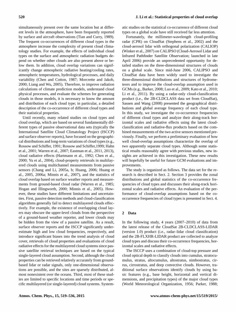
Figure 1. (a) The global distribution (2◦× 2◦ grid boxes) of annu-
ally averaged multilayered cloud fraction. (b) The zonal distribu-
tions of seasonal, averaged multilayered cloud fraction.
served by CALIPSO mostly reflect real cloud processes, even
when the strong solar noise signature impacts the compar-
isons of cloud types between day and night, particularly for
cirrus. For other cloud types, the uncertainty caused by the
daylight noise for lidar may be smaller. Thus, the calculated
annual mean cloud fractions for different cloud types in this
investigation are reliable.
3 Simultaneous co-occurrence of different cloud types
3.1 Zonal distributions of overlapping clouds
Multilayered cloud systems frequently occur in the atmo-
sphere. Our statistical results show that the seasonal varia-
tions in multilayered cloud percentages are small, and the
seasonal, globally averaged values range between 25 and
28 %. These results are comparable to the multilayered cloud
fractions (approximately 27 %) from the Geoscience Laser
Altimeter System (GLAS) (Wylie et al., 2007). Furthermore,
we plot the global and zonal distributions of the annually av-
eraged multilayered cloud fractions (see Fig. 1). In Fig. 1a,
the high-value and low-value centers of the multilayered
−80 −60 −40 −20 0 20 40 60 800
2
4
6
8
10
12
14
16
Latitude
Occ
urre
nce
freq
uenc
ies
(%)
(a) Zonal variation of different cloud types overlap percentage
High+AsHigh+AcHigh+St/ScHigh+CuAs+St/Sc
−80 −60 −40 −20 0 20 40 60 800
1
2
3
4
5
Latitude
Occ
urre
nce
freq
uenc
ies
(%)
(b) Zonal variation of different cloud types overlap percentage
High+NsHigh+DcAs+CuAc+St/ScAc+Cu
Figure 2. Zonal distributions of annual most frequently occur-
ring multilayered cloud types based on the 2B-CLDCLASS-LIDAR
product.
cloud fractions are very obvious. For example, equatorial
central South America, western Africa, Indonesia and the
west-central Pacific Ocean warm pool are typical high-value
centers. There are three obvious peaks in the zonal mean pat-
terns (Fig. 1b): one major peak occurs in the tropics, and
two minor peaks occur in the midlatitudes; two local minima
occur in the subtropics. The local maximum during spring
(thick, black line) in the northern midlatitudes may be the
result of misidentifying high-level dust transport as high ice
clouds or the result of the actual influences of dust on ice
nucleation (Chen et al., 2010; Yu et al., 2012; Yuan and Ore-
opoulos, 2013).
In all multilayered clouds, we further identify the most
frequently multilayered cloud systems (annually) and pro-
vide their zonal distributions (Fig. 2). Note that the over-
lap of the same cloud type (e.g., High+High) is not impor-
tant in numerical climate simulations because these clouds
have similar cloud properties and temperatures. Thus, treat-
ing these clouds as a single layer may not introduce seri-
ous errors into the calculation of the cloud properties (Wang
and Dessler, 2006). In addition, the overlap of two specific
Atmos. Chem. Phys., 15, 519–536, 2015 www.atmos-chem-phys.net/15/519/2015/
J. Li et al.: Statistical properties of cloud overlap 523
cloud types in any three- or more layer cloud systems (e.g.,
High+As+Cu) is also included in statistical results of their
occurrence frequencies. But, in Sect. 3.3, only two-layer
cloud systems are used when we calculate the weighted cloud
radiative effect of two specific cloud types overlap. Figure 2
clearly indicates that the zonal patterns of different combina-
tions of cloud types are very different. For example, multilay-
ered cloud systems that include high clouds either have one
peak in the tropics (High+Ac and High+Cu) or three peaks
in the tropics and midlatitudes (High+St / Sc, High+Ns
and High+As). The high clouds that represent the major
peak in the tropics may be caused by large-scale ascent or
by dissipating deep convection. However, gentle large-scale
ascent and ice cloud production within frontal convection are
likely responsible for the two minor peaks of the multilay-
ered cloud systems along midlatitude storm tracks. In addi-
tion to these combinations of cloud types, As-over-stratiform
clouds or Ac-over-stratiform clouds also tend to be concen-
trated in the midlatitudes (60◦ and poleward). In fact, the dis-
tributions of clouds in different geographical regimes depend
on the large-scale circulation, but the environmental factors
in the same regimes, such as sea surface temperature, lower
tropospheric stability, and vertical velocity are also important
to the occurrences of different cloud types (Klein and Hart-
mann, 1993; Norris and Leovy, 1994). By studying the rela-
tions between various cloud types and the sea surface tem-
perature (SST) of the tropical oceans, Behrangi et al. (2012)
indicated that as the SST increases, the fraction of multilay-
ered clouds increases up to a SST of 303 K and then de-
creases for SSTs greater than 303 K. The ranges of SSTs
are very different for different combinations of cloud types;
e.g., high clouds over St / Sc or Ns clouds tend to occur be-
tween 292 and 294 K, but high clouds over Ac, As or Cu
clouds tend to occur between 302 and 304 K, even though al-
most all of the clouds have major peak values in the tropics.
In addition, Yuan and Oreopoulos (2013) indicated that the
vertical velocity of large-scale pressure systems has a neg-
ative correlation with the percentage of multilayered cloud
systems. Strong subsidence favors low cloud formation and
suppresses ice cloud generation; thus, multilayered clouds
are infrequent over major Sc-dominated oceanic areas at lat-
itudes near 30◦ S.
However, multilayered cloud systems are very difficult to
detect by passive satellites (such as ISCCP) and by surface
weather reporters, particularly during the nighttime and for
cloud systems that include very thin cirrus (Sassen and Cho,
1992; Liao et al., 1995). For example, when a high-level
transparent cirrus cloud overlies a boundary-layer stratus
cloud, the retrieved cloud-top heights typically lie between
the cirrus and stratus cloud heights (e.g., Baum and Wielicki,
1994), leading to the misinterpretation of cloud types by IS-
CCP. For cloud property retrievals, the influence of liquid
water clouds and precipitation on the radiances observed at
the TOA is also one of the greatest impediments to determin-
ing the cloud ice mass for multilayered systems that include
ice clouds above water clouds (Huang, 2006).
3.2 Global statistics of cloud overlap
The global average percentage overlap of different combina-
tions of cloud types over land or ocean during the daytime
and nighttime are provided in Tables 1 and 2, respectively.
These tables show that high clouds, As, Ac and Cu tend to
co-exist with other cloud types, regardless of the time of day
or surface type. The frequency of High-over-Ac over ocean
may even exceed the frequency of single-layered Ac clouds
over ocean, indicating that these two types actually exhibit a
stronger meteorological association. However, St/Sc and Ns
are much more likely to exhibit individual features than other
types, particularly St/Sc over the ocean. Convective clouds
are also typically in single layers. Although Cu clouds form
in unstable air and As clouds form in stable air, a small per-
centage of overlap occurs. Globally, 44 % (50 %) and 35 %
(39 %) of low clouds (St / Sc+Cu) over land and ocean dur-
ing the daytime (nighttime) are overlapped by other cloud
types aloft. Approximately 23 % (26 %) and 20 % (25 %) of
low clouds over land and ocean during the daytime (night-
time) are connected with high clouds. These percentages
are comparable to those (approximately 30 %) presented by
Yuan and Oreopoulos (2013). Notably, high clouds also in-
clude cirrostratus and cirrocumulus; thus, the percentage of
overlap of deep convection below high clouds is approxi-
mately 29 %, which is larger than the percentage (approxi-
mately 24 %) of cirrus-over-convection clouds based on ICE-
Sat (Ice, Cloud,and land Elevation Satellite))/GLAS (Wang
and Dessler, 2006).
Based on the above figures and tables, we plot the global
distributions of the annual mean dominant cloud types and
their cloud fractions. Here, the cloud types include all single-
layered and multilayered cloud systems (see Fig. 3a, b). Fig-
ure 3c and d show the global distributions of the annual mean
cloud types (only for multiple dominant clouds) and corre-
sponding cloud amounts. Based on Fig. 3a and b, St/Sc is the
dominant cloud type worldwide, particularly over the ocean.
High clouds are mainly concentrated in the tropics and sub-
tropics. In addition, over Antarctica, the most frequent cloud
type is As. These results are in reasonable agreement with
the findings based on the ISCCP D1 data set (Doutriaux-
Boucher and Seze, 1998). However, Fig. 3a and b also show
that As prevails over the arid/semiarid land in the Northern
Hemisphere, such as northwestern China and North Amer-
ica. In contrast, Ac is dominant over the arid/semiarid land
of the Southern Hemisphere, such as Australia and south-
ern Africa. However, not all of these features are observed
by Doutriaux-Boucher and Seze (1998) using the ISCCP D1
data set. In fact, the obvious regional and seasonal variations
in Ac and As are possibly related to the frequency of dust
activities (Choi et al., 2009). In addition, over some deserts
(such as the Sahara), the most prevalent cloud type are low-
www.atmos-chem-phys.net/15/519/2015/ Atmos. Chem. Phys., 15, 519–536, 2015

524 J. Li et al.: Statistical properties of cloud overlap
Table 1. Globally averaged overlapping percentages of different cloud types over land and ocean during daytime.
SLa MLb High As Ac St/Sc Cu Ns Deep Surface
High 8.8
8.8
14.5
16.4
3.7
4.1
2.5
2.2
4.3
3.5
3.2
5.2
2.8
3.5
1.0
1.2
0.4
0.3
Land
Ocean
As 6.5
4.2
6.7
6.1
–
--
0.9
0.5
1.0
0.9
2.0
2.5
1.1
1.0
0.4
0.3
–
–
Land
Ocean
Ac 5.3
3.1
7.0
6.4
–
–
0.01
0.01
1.1
0.8
0.9
1.5
1.1
1.0
0.04
0.08
–
–
Land
Ocean
St / Sc 10.5
21.9
6.2
9.4
–
–
–
–
–
–
0.3
0.4
0.5
0.7
–
–
–
–
Land
Ocean
Cu 3.9
6.6
5.1
5.9
–
–
–
–
–
–
0.1
0.2
0.3
0.3
–
–
–
–
Land
Ocean
Ns 4.0
4.1
1.5
1.6
–
–
–
–
–
–
0.02
0.02
0.09
0.05
–
–
–
–
Land
Ocean
Deep 0.8
0.8
0.4
0.3
–
–
–
–
–
–
–
–
–
–
–
–
–
–
Land
Ocean
a The SL represents the single-layered cloud.b The ML represents the multilayered cloud. The boldfaced values indicate the overlapping percentages of different cloud types over ocean.
Table 2. Globally averaged overlapping percentages for different cloud types over land and ocean during nighttime.
SLa MLb High As Ac St/Sc Cu Ns Deep Surface
High 12.0
8.8
17.4
20.8
5.5
4.7
3.2
2.3
6.6
5.0
2.6
7.6
1.8
4.4
1.3
1.3
0.3
0.3
Land
Ocean
As 6.9
3.9
7.4
6.3
–
–
1.0
0.4
1.1
0.9
1.9
2.6
0.9
1.0
0.4
0.3
–
–
Land
Ocean
Ac 4.6
3.1
8.5
8.1
–
–
0.01
0.01
1.2
1.0
0.7
1.9
0.6
1.2
0.05
0.08
–
–
Land
Ocean
St / Sc 6.4
23.8
5.1
12.1
–
–
–
–
–
–
0.2
0.4
0.3
0.8
–
–
–
–
Land
Ocean
Cu 2.0
5.9
3.4
6.9
–
–
–
–
–
–
0.1
0.2
0.2
0.4
–
–
–
–
Land
Ocean
Ns 3.9
4.0
1.7
1.7
–
–
–
–
–
–
–
–
0.08
0.05
–
–
–
–
Land
Ocean
Deep 0.8
0.9
0.3
0.3
–
–
–
–
–
–
–
–
–
–
–
–
–
–
Land
Ocean
a The SL represents the single-layered cloud.bThe ML represents the multilayered cloud. The boldfaced values indicate the overlapping percentages of different cloud types over ocean.
level clouds (St/Sc) according to the ISCCP D1, as opposed
to the high clouds in our results. This discrepancy may be
due to inadequate identification of airborne dust, such as the
ISCCP misclassifying dust as low-level clouds, as suggested
by the low values of the effective droplet radius reported by
Han et al. (1994) over these regions.
Generally, the High-over-St/Sc and High-over-Cu cloud
systems are more common over the vast oceans of the trop-
ics and midlatitudes, while High-over-Ac cloud systems tend
to exist over land at the same latitudes (see Fig. 3c). No-
tably, As-over-Cu only occurs over northwestern China. In
addition, the As-over-St/Sc cloud systems are dominant in
the high latitudes. Figure 3d shows the multilayered cloud-
type amount, defined as the ratio of the cloud fraction of
one multilayered cloud combination to the cloud fraction
of total multilayered cloud systems. In addition, we note
that some multilayered cloud systems (High-over-St/Sc) ex-
ist over the major Sc-dominated oceanic areas, which are
generally unfavorable for upper-level cloud formation due
to persistent strong subsidence. The major sources of high
clouds are topography-driven gravity wave activity, advec-
tion from neighboring tropical convection centers, such as
the Amazon Basin or the Congo Basin, or ascent associated
with midlatitude fronts.
3.3 Along-track horizontal scales and radiative effects
of cloud overlap
The horizontal scale of a multilayered cloud system along
the CALIPSO/CloudSat track is determined by calculating
Atmos. Chem. Phys., 15, 519–536, 2015 www.atmos-chem-phys.net/15/519/2015/

J. Li et al.: Statistical properties of cloud overlap 525
(a) Annual mean dominant cloud type
No data
High
As
Ac
St+Sc
Cu
Ns
Dc
Cloud Type
120W 60W 0 60E 120E 180E
60N
30N
0
30S
60S
90S
(b) Cloud fraction of dominant cloud type
120W 60W 0 60E 120E 180E
60N
30N
0
30S
60S
90S
0.1
0.2
0.3
0.4
0.5
0.6
0.7
0.8
0.9
1
(c) Annual mean dominant multiple cloud type
No data
High+High
High+As
High+Ac
High+(St/Sc)
High+Cu
High+Ns
As+As
As+(St/Sc)
As+Cu
Cloud Type
120W 60W 0 60E 120E 180E
60N
30N
0
30S
60S
90S
(d) Cloud amount of dominant multiple cloud type
120W 60W 0 60E 120E 180E
60N
30N
0
30S
60S
90S
0.1
0.2
0.3
0.4
0.5
0.6
0.7
0.8
0.9
1
Figure 3. The global distributions of (a) the annual mean dominant cloud types and (b) the corresponding cloud fractions, and of (c) the
annual mean dominant multiple cloud types and (d) the corresponding cloud amounts.
−80 −60 −40 −20 0 20 40 60 800
5
10
15
20
25
30
Latitude
Alo
ngīt
rack s
cale
(km
)
(a) Zonal variation of cloud along−track horizontal scales
High+AsHigh+AcHigh+Sc/StAs+Sc/StAc+Sc/St
−80 −60 −40 −20 0 20 40 60 800
5
10
15
20
25
30
Latitude
Alo
ng−tra
ck s
cale
(km
)
(b) Zonal variation of cloud along−track horizontal scales
High+CuHigh+NsHigh+DcAs+CuAc+Cu
101 10210−6
10−5
10−4
10−3
10−2
10−1
100
Along−track scale (km)
P D
F
(c) The PDF distributions of cloud along−track horizontal scales
High+As (Mean: 12.8km STD:18.7km)High+Ac (Mean: 11.0km STD:17.8km)High+Sc/St (Mean: 14.1km STD:21.3km)As+Sc/St (Mean: 17.4km STD:23.5km)Ac+Sc/St (Mean: 6.7km STD:9.8km)
101 10210−6
10−5
10−4
10−3
10−2
10−1
100
Along-track scale (km)
P D
F
(d) The PDF distributions of cloud along−track horizontal scales
High+Cu (Mean: 4.1km STD:5.7km)High+Ns (Mean: 15.1km STD:22.5km)High+Dc (Mean: 11.9km STD:16.5km)As+Cu (Mean: 3.9km STD:6.0km)Ac+Cu (Mean: 2.8km STD:3.1km)
Figure 4. (a, b) The zonal variation of cloud along-track horizontal scales for these multilayered cloud systems and (c, d) their probability
distribution.
www.atmos-chem-phys.net/15/519/2015/ Atmos. Chem. Phys., 15, 519–536, 2015

526 J. Li et al.: Statistical properties of cloud overlap
−80 −60 −40 −20 0 20 40 60 80−500
−450
−400
−350
−300
−250
−200
−150
−100
−50
0
Latitude
CR
F (W
/M2 )
(a) Zonal variation of cloud radiative effect (TOA)
High+AsHigh+AcHigh+Sc/StAs+Sc/StAc+Sc/St
−80 −60 −40 −20 0 20 40 60 80−500
−450
−400
−350
−300
−250
−200
−150
−100
−50
0
Latitude
CR
F (W
/M2 )
(b) Zonal variation of cloud radiative effect (TOA)
High+CuHigh+NsHigh+DcAs+CuAc+Cu
−80 −60 −40 −20 0 20 40 60 80−12
−10
−8
−6
−4
−2
0
Latitude
CR
F (W
/M2 )
(c) Zonal variation of weighted cloud radiative effect (TOA)
High+AsHigh+AcHigh+Sc/StAs+Sc/StAc+Sc/St
−80 −60 −40 −20 0 20 40 60 80−12
−10
−8
−6
−4
−2
0
Latitude
CR
F (W
/M2 )
(d) Zonal variation of weighted cloud radiative effect (TOA)
High+CuHigh+NsHigh+DcAs+CuAc+Cu
Figure 5. (a–d) The zonal distributions of instantaneous net cloud radiative effect and weighted instantaneous net cloud radiative effect by
considering the frequency of occurrence of each cloud type for different multilayered cloud systems at the TOA during daytime (that is,
overpass time of satellite).
the number of continuous profiles (N), in which each profile
includes a vertical column with a particular combination of
cloud types. Considering the 1.1 km along-track resolution
of CPR measurements, the along-track scale (L in km) of
a multilayered cloud system is L=N × 1.1 (Zhang et al.,
2014).
Figure 4a–d present the zonal variation in the along-track
horizontal scales of clouds in the multilayered cloud systems
and their probability distribution functions (PDFs). As shown
in Fig. 4a and b, the High+St/Sc, As+St/Sc, High+Ns
and High+Dc cloud systems have obvious zonal variations.
High+St/Sc and As+St/Sc have minimum scales (approx-
imately 10 km) in the tropics and maximum scales (up to
20 km) poleward of 40◦ (i.e., along the storm tracks). How-
ever, the along-track horizontal scales of High+Ns and
High+Dc decrease from the tropics to the poles. The zonal
variations in the scales of other clouds systems are small,
particularly for High+Cu, As+Cu and Ac+Cu (approxi-
mately 3 km). We also provide the global average along-track
horizontal scales and standard deviation (SD) of these cloud
systems in Fig. 4c and d. Generally, As+St/Sc has a max-
imum scale of 17.4 km and SD of 23.5 km, while Ac+Cu
has a minimum scale of 2.8 km and SD of 3.1 km. The result
in which the standard deviations are larger than mean val-
ues of the cloud scale was also found in the study of Zhang
et al. (2014). They showed that the global mean Ac along-
track horizontal scale is 40.2 km, but the standard deviation
reaches 52.3 km. It is clear that the along-track horizontal
scales of these cloud systems all have considerable variations
globally. By assuming a typical grid resolution of 1◦ in global
climate models, we find that all multilayered cloud types can-
not be resolved by global climate models. The multilayered
cloud systems that include Cu (such as High+Cu, Ac+Cu
and As+Cu) are not even captured by regional climate mod-
els with higher grid resolutions (approximately 15 km).
Furthermore, Fig. 5a and b show the zonal distributions of
the instantaneous net TOA cloud radiative effects (CREs) of
these multilayered cloud systems at overpass time of satellite
during the daytime. In addition, we also provide the zonal
distributions of weighted instantaneous net CREs by consid-
ering the frequency of occurrence of each cloud type during
the daytime only (Fig. 5c, d). Although the zonal distribu-
tions of the net CREs for these cloud systems are similar,
i.e., decrease from the tropics to high latitudes, the radiative
effects can be grouped into several distinct classes. For ex-
ample, middle-over-low (such as As+Sc/St and As+Cu)
cloud systems have comparable radiative effects (maxi-
mum value of −300 W m−2), while high-over-low (such as
Atmos. Chem. Phys., 15, 519–536, 2015 www.atmos-chem-phys.net/15/519/2015/

J. Li et al.: Statistical properties of cloud overlap 527
−80 −60 −40 −20 0 20 40 60 80−700
−600
−500
−400
−300
−200
−100
0
Latitude
CR
F (W
/M2 )
(a) Zonal variation of cloud radiative effect (Surface)
High+AsHigh+AcHigh+Sc/StAs+Sc/StAc+Sc/St
−80 −60 −40 −20 0 20 40 60 80−700
−600
−500
−400
−300
−200
−100
0
Latitude
CR
F (W
/M2 )
(b) Zonal variation of cloud radiative effect (Surface)
High+CuHigh+NsHigh+DcAs+CuAc+Cu
−80 −60 −40 −20 0 20 40 60 80−12
−10
−8
−6
−4
−2
0
Latitude
CR
F (W
/M2 )
(c) Zonal variation of weighted cloud radiative effect (Surface)
High+AsHigh+AcHigh+Sc/StAs+Sc/StAc+Sc/St
−80 −60 −40 −20 0 20 40 60 80−12
−10
−8
−6
−4
−2
0
Latitude
CR
F (W
/M2 )
(d) Zonal variation of weighted cloud radiative effect (Surface)
High+CuHigh+NsHigh+DcAs+CuAc+Cu
Figure 6. Same as Fig. 5, but at the surface during the daytime.
High+Sc/St and High+Cu) cloud systems have small ra-
diative effects (maximum value of −150 W m−2). By con-
sidering the weight of each multilayered cloud type, we find
that their contributions to the cloud radiative effect of the
whole multilayered cloud system are different (Fig. 5c, d).
In the tropics, High+Ac and High+Cu contribute −9 and
−8 W m−2, respectively, to the net radiative effects. Other
cloud types have obvious zonal distributions, and their con-
tributions range from 0 to −6 W m−2. In mid–high latitudes,
some mid-over-low (such as As+Sc/St) cloud systems are
more important to the regional energy balance, particularly
over the Southern Ocean regions. Similar to Fig. 5, Fig. 6
presents the surface-based results during the daytime. In
summary, the trends are similar, but all cloud types have
larger radiative effects at the surface than at the TOA; specif-
ically, the effect is an obvious surface cooling. Clearly, the
energy differences in the net cloud radiative effects between
the surface and the TOA are persistent and may significantly
change the atmospheric radiative heating/cooling rates and
temperature. However, the zonal variations of the instan-
taneous net CREs in the atmosphere show that the radia-
tive impacts are very distinct for the different multilayered
cloud types (see Fig. S1 in the Supplement). Most of the
multilayered cloud types heat atmosphere (their peak val-
ues range from 0.5 to 3 W m−2) almost at all latitudes ex-
cept As+Sc/St, Ac+Sc/St and High+Sc/St cloud systems,
which cause a weak atmospheric cooling (peak value is ap-
proximately −1 W m−2) at mid and high latitudes. In addi-
tion, statistical results also further show that the combined
net CRE of the 10 multilayered cloud types in the atmosphere
decreases from the tropics to high latitudes, its value ranges
from 13 (heating effect) to −3 W m−2 (cooling effect).
Figure 7a and b show the global mean instantaneous net
radiative effects of the 10 multilayered cloud systems range
from−100 to−350 W m−2, except for High+Dc (the black
dots are the mean values and the lines represent the stan-
dard deviation). In Fig. 7c and d, the black bars represent
the weighted global mean instantaneous net radiative effects
of each cloud type at the TOA and surface. By combin-
ing the all single-layered and multilayered cloud systems,
the global mean total net CREs are approximately −103.1
and −118.8 W m−2 at the TOA and at the surface, respec-
tively. The all multilayered cloud systems contribute approx-
imately 40.1 % (−41.3 W m−2) and 42.3 % (−50.2 W m−2)
to the global mean total net CREs at the TOA and at the sur-
face, respectively. Clearly, the existence of a multilayered
cloud system is important to Earth’s radiative energy bal-
ance. A further analysis shows that all two-layered and three-
layered (or more layers) cloud systems contribute approx-
imately −27.2 W m−2 (−33.1 W m−2) and −14.1 W m−2
(−17.1 W m−2), respectively, to the total cloud radiative ef-
fects at the TOA (surface). However, the radiative effects
of 10 multilayered cloud types in our study are −22.7 and
−27.1 W m−2 at the TOA and at the surface (a contribution
www.atmos-chem-phys.net/15/519/2015/ Atmos. Chem. Phys., 15, 519–536, 2015

528 J. Li et al.: Statistical properties of cloud overlap
−800
−700
−600
−500
−400
−300
−200
−100
0(a) Global average cloud radiative effect (TOA)
Clo
ud r
adia
tive
effe
ct (
W/M
2 )
High+As
High+Ac
High+Sc/St
As+Sc/St
Ac+Sc/St
High+Cu
High+Ns
High+DcAs+Cu
Ac+Cu−800
−700
−600
−500
−400
−300
−200
−100
0(b) Global average cloud radiative effect (Surface)
Clo
ud r
adia
tive
effe
ct (
W/M
2 )
High+As
High+Ac
High+Sc/St
As+Sc/St
Ac+Sc/St
High+Cu
High+Ns
High+DcAs+Cu
Ac+Cu
−6
−4.5
−3
−1.5
0
Clo
ud r
adia
tive
effe
ct (
W/M
2 )
(c) Weighted global average cloud radiative effect (TOA)
High+As
High+Ac
High+Sc/St
As+Sc/St
Ac+Sc/St
High+Cu
High+Ns
High+DcAs+Cu
Ac+Cu
CRE=−22.7 W/M2
0
1
2
3
4
Wei
ght
−6
−4.5
−3
−1.5
0
Clo
ud r
adia
tive
effe
ct (
W/M
2 )
(d) Weighted global average cloud radiative effect (Surface)
High+As
High+Ac
High+Sc/St
As+Sc/St
Ac+Sc/St
High+Cu
High+Ns
High+DcAs+Cu
Ac+Cu
CRE=−27.1 W/M2
0
1
2
3
4
Wei
ght
Figure 7. The global average instantaneous net cloud radiative effect and weighted instantaneous net cloud radiative effect for different
multilayered cloud types at the TOA and surface only during daytime. The gray line presents the global average frequency of occurrence of
each cloud type only during daytime (that is, weights). The total weighted instantaneous net cloud radiative effects of 10 multilayered cloud
systems are also shown in (c) and (d): TOA (−22.7 W m−2) and surface (−27.1 W m−2).
of 22 %). High+Ac and High+Sc/St (or Cu) have rela-
tively smaller effects than High+Dc and Ac+Sc/St (or Cu),
but their contributions to the cloud radiative effect of the
all multilayered cloud systems are highest because of their
more frequent occurrence, larger weights (see the gray line
in Fig. 7c, d), and distribution from the tropics to the midlat-
itudes (Fig. 3). However, the other cloud types may be im-
portant to regional cloud radiative effects. For example, mid-
to-upper-level clouds frequently coexist with boundary-layer
clouds (e.g., As+St / Sc and High+St / Sc) over the South-
ern Ocean; thus, mid-atmosphere cloudiness is overestimated
by ISCCP and is partially responsible for the TOA shortwave
radiation bias in the climate models over this region (Haynes
et al., 2011).
4 Evaluation of cloud-overlap assumptions based on
cloud types
Based on the advantages of the two active sensors, we pre-
liminarily evaluate how well the cloud-overlap assumptions
can characterize the overlap of two apparently separate cloud
types using the 2B-CLDCLASS-LIDAR cloud type prod-
uct. The cloud overlap assumption has been widely used
to describe the actual vertical distribution of clouds and
the parameterization of the total cloud fraction in a given
model grid box. Several basic cloud-overlap assumptions
have been proposed, such as maximum, random, random-
maximum and minimum overlaps (Hogan and Illingworth,
2000). The most common cloud-overlap scheme in cur-
rent GCMs is called “random-maximum” overlap, which as-
sumes that cloud layers separated by clear layers are ran-
domly overlapped, while vertically continuous cloud layers
have maximum overlap (Stephens et al., 2004). When the
cloud fractions of the upper and lower layers are C1 and C2,
the total cloud fractions of the two cloud layers based on the
overlap assumptions are given by
Crandom = C1+C2−C1×C2,
Cmax =max(C1,C2), and
Cmin =min(1,C1+C2). (1)
In addition, if we know the actual overlap fraction Coverlap,
then the observed total cloud fraction Creal can be written as
Creal = C1+C2−Coverlap. (2)
However, Hogan and Illingworth (2000) proposed a simpler
and more useful expression for the degree of cloud-layer
Atmos. Chem. Phys., 15, 519–536, 2015 www.atmos-chem-phys.net/15/519/2015/

J. Li et al.: Statistical properties of cloud overlap 529
overlap (exponential random overlap). In the expression, the
mean observed cloud fraction of two cloud layers can be de-
termined by the linear combination of the maximum and ran-
dom overlap in terms of an “overlap parameter”a:
Creal = a×Cmax+ (1− a)×Crandom. (3)
Here, the overlap parameter a is considered a function of the
layer separation and related to the vertical resolution and the
horizontal domain size. a = 0 is random overlap and a =1
is the maximum overlap. As Creal increasingly departs from
Cmax (trending toward Cmin), a becomes negative, indicating
a tendency for an even lower degree of overlap than that pre-
dicted by the random overlap assumption. In fact, previous
studies already have shown that the cloud overlap parameter
is sensitive to the spatial scale of the GCM’s grid box. For
example, Hogan and Illingworth (2000) found that a tends
to increase with decreasing spatial and temporal resolution
(that is, with an increasing vertical and horizontal scale of
GCMs), but one interesting finding is that, with a tempo-
ral resolution of 3 h (that is, horizontal scale of 216 km in
their study) and a level separation of between 6 and 8 km,
a falls to −0.1. Mace et al. (2002) also found an increase
in a with decreasing temporal resolution at all sites but the
southern Great Plain (SGP) site while they found a decrease
in a with decreasing spatial resolution. However, Naud et
al. (2008) found a decrease in a with increasing spatial reso-
lution by analyzing the cloud overlap at the SGP site for the
winter months. These studies further implied that the degree
of cloud overlap also may depend on the other factors, such
as atmospheric vertical motion, convective stability and wind
shear in different seasons besides vertical resolution and the
horizontal domain size (Mace et al., 2002; Naud et al., 2008).
For example, vertically continuous clouds tend to be more
maximally overlapped in the presence of vertical motion in
midlatitudes and decreased convective stability in the trop-
ics. However, large wind shears were found to increase the
randomness of the overlap, with the overlap becoming less
than random in some cases (a<0). What changes from one
high to low horizontal resolution is actually the increase of
number of samples, which in turn may affect the averaged
values of the vertical velocity, convective stability and wind
shear, thus, further affecting the way cloudy layers overlap.
Based on several months of data from ICESat/GLAS ob-
servations, Wang and Dessler (2006) showed that overlap
differences between the observed and random overlaps ex-
ist when describing the actual overlap of two separated cloud
types (vertical separation > 0.5 km). However, the authors’
work focused on the tropics and was limited to simple cloud
classifications using space-based lidar. We expand the study
by Wang and Dessler (2006) by employing a global-scale
analysis and a more complete cloud classification; the over-
lap of two separate cloud types (here, vertical separation
> 0.24 km at least) in each combination of cloud types in each
grid box is determined. Moreover, we evaluate the perfor-
mances of the random overlap assumption and calculate the
overlap parameter a for each multilayered cloud type in each
2◦× 2◦ grid box.
We first group each multilayered cloud system. For exam-
ple, for the all High+Cu multilayered cloud systems in the
same 2◦× 2◦ grid box, we consider two layers and group all
high clouds into the upper layer and all cumulus clouds into
the lower layer, regardless of the vertical separation between
these two types and their heights. Then, four possible values
for the combined total cloud fraction of the two cloud types
at different layers are calculated by assuming random over-
lap, maximum overlap, minimum overlap and actually ob-
served overlap. Because random cloud overlap is considered
a better characterization of cloud overlap behavior than min-
imum overlap and maximum overlap when two cloud lay-
ers separated by clear layers, we only provide the difference
in the cloud fractions between random overlap and actually
observed overlap. Finally, the overlap parameter a for each
multilayer in each grid is calculated based on Eq. (3). No-
tably, because we do not group multilayered cloud types into
multiple layers according to the vertical separation of two
types, only one value for the overlap parameter a for each
multilayered cloud system in each grid is obtained. a may be
considered the mean value of all overlap parameters at differ-
ent layer separations. Here, we define the relative difference
(RD) between the random and actual overlap for one of the
multilayered cloud types as
RD= (Crandom−Creal)/Creal. (4)
In addition, the cumulative relative difference (CRD) be-
tween the random and actual overlap for all multilayered
cloud types (here, 17 different combinations of different
cloud types are considered) in each 2◦× 2◦ grid box is given
by
CRD=
17∑i=1
RDi×wi i = 1,2,3, . . .,17. (5)
Similar to the definition of CRD, we define the cumulative
overlap parameter (COP) in each 2◦× 2◦ grid box as
COP=
17∑i=1
ai×wi i = 1,2,3, . . .,17, (6)
where w is the weight coefficient for one multilayered cloud
type in each 2◦× 2◦ grid box as follows:
wi= f i
/17∑i=1
f i i = 1,2,3, . . .,17. (7)
f is the cloud fraction of each multilayered cloud type in
every grid box.
Figure 8a and b show the zonal distributions of the rela-
tive differences between the random and actual overlap for
10 of the main multilayered cloud types and the cumula-
tive relative differences for all multilayered cloud types (gray
www.atmos-chem-phys.net/15/519/2015/ Atmos. Chem. Phys., 15, 519–536, 2015

530 J. Li et al.: Statistical properties of cloud overlap
−80 −60 −40 −20 0 20 40 60 80−6−5−4−3−2−1
012345678
Latitude
Rel
ativ
e di
ffere
nce
(%)
(a) Zonal variation of relative difference
High+As High+Ac High+St/Sc As+St/Sc Ac+St/Sc
−80 −60 −40 −20 0 20 40 60 80−3
−2
−1
0
1
2
3
4
Latitude
Rel
ativ
e di
ffere
nce
(%)
(b) Zonal variation of relative difference
High+Cu High+Ns High+Deep As+Cu Ac+Cu total
−80 −60 −40 −20 0 20 40 60 80−0.5
−0.4
−0.3
−0.2
−0.1
0
0.1
0.2
0.3
0.4
0.5
Latitude
Ove
rlap
para
met
er
(c) Zonal variation of overlap parameter
High+Ns High+Deep High+St/Sc As+St/Sc Ac+St/Sc
−80 −60 −40 −20 0 20 40 60 80−0.3
−0.2
−0.1
0
0.1
0.2
0.3
0.4
LatitudeO
verla
p pa
ram
eter
(d) Zonal variation of overlap parameter
High+Cu High+As High+Ac As+Cu Ac+Cu total
Figure 8. (a, b) The zonal distributions of the relative difference between the random and actual overlap for different multilayered cloud
types and the cumulative relative difference of all multilayered cloud types (gray line). (c, d) The zonal distributions of the overlap parameter
for different multilayered cloud types and the cumulative overlap parameter of all multilayered cloud types (gray line).
line). The results show that differences exist, even though
the random-cloud-overlap assumption is thought to better
describe cloud-overlap behavior than other schemes when
the cloud layers appear to be separate. The cloud fractions
based on the random-overlap assumption are underestimated
for High+St/Sc, As+St/Sc and Ac+St/Sc at all latitudes;
these differences can exceed−5 %. The cloud fraction of the
High-over-Ac system is overestimated at all latitudes. The
peak values of the difference are mainly located in mid and
high latitudes in both hemispheres and are of up to 5 %. For
other types, the relative differences are smaller and change
with latitude. In summary, the cumulative relative difference
of all multilayered cloud types is small (gray lines), and most
values are negative at all latitudes. In Fig. 8c and d, we fur-
ther show the zonal distributions of the overlap parameter for
10 of the main multilayered cloud types and the cumulative
overlap parameter of all multilayered cloud types. Clearly,
the overlap parameters for High+St/Sc, As+St/Sc and
Ac+St/Sc at all latitudes are negative, indicating a Creal de-
parture from Cmax (trending toward Cmin) and a tendency for
an even lower degree of overlap than predicted by the random
overlap assumption. Thus, the linear combination of maxi-
mum and random overlap assumptions is problematic due to
the negative overlap parameters in those regions, where the
three multilayered cloud types mentioned above are domi-
nant, particularly over the major Sc-dominated oceanic areas.
However, the overlap parameters are positive for High+Ns
and High+Ac. Thus, Creal has a value between Cmax and
Crandom, and the exponential random overlap can predict the
actual overlap of these two types very well. These results are
intuitive, as cloud types are governed by different types of
atmospheric motion and state. The formation of cumuliform
clouds may be related to the strong ascent or convectively
unstable atmosphere which result in clouds that increase in
height more quickly, and increasing the degree of overlap
with other cloud types. However, random or minimum over-
lap occurs preferentially in regions of subsidence or convec-
tive stability (favors stratiform cloud). Therefore, it is not
difficult to understand why the zonal distributions of cloud
overlap parameters are very different for similar cloud over-
lap systems (e.g., middle-over-low). For example, the over-
lap parameters of As+St/Sc and Ac+St/Sc over the South-
ern Ocean are obviously distinct from As+Cu and Ac+Cu.
In summary, the cumulative overlap parameters of all mul-
tilayered cloud types (gray lines) are negative at nearly all
latitudes. However, two points still require further interpre-
tation. First, the cumulative overlap parameters in the trop-
ics and in the Northern Hemisphere have small values (and
possibly positive values); thus, random overlap or exponen-
tial random overlap is representative of the actual conditions.
Second, in the Southern Hemisphere, the cumulative overlap
parameters trend toward Cmin; thus, a better prediction using
random overlap or exponential random overlap is difficult.
This finding partially explains why the climate model errors
in the TOA fluxes over the Southern Ocean are the largest
(Trenberth and Fasullo, 2010). Based on the global results
from this study, we also further support the findings of Naud
et al. (2008) that factors such as dynamics could be con-
Atmos. Chem. Phys., 15, 519–536, 2015 www.atmos-chem-phys.net/15/519/2015/

J. Li et al.: Statistical properties of cloud overlap 531
(a) Cumulative relative difference
−135 −90 −45 0 45 90 135
60
30
0
−30
−60
−4
−3
−2
−1
0
1
2
3
4
5
6
(b) Cumulative overlap parameter
−135 −90 −45 0 45 90 135
60
30
0
−30
−60
−0.4
−0.3
−0.2
−0.1
0
0.1
0.2
0.3
0.4
0.5
0.6
Figure 9. The global distributions of (a) the cumulative relative dif-
ference and (b) the cumulative overlap parameter of all multilayered
cloud types.
nected to the way cloudy layers overlap. As a result, we sug-
gest that a linear combination of minimum and random over-
lap assumptions may further improve the predictions of real
cloud fractions for the multilayered cloud types in the South-
ern Hemisphere (e.g., As+St/Sc and Ac+St/Sc), particu-
larly poleward of 40◦ S over the ocean. However, only three
cloud types (e.g., low-level marine stratus, convective clouds
and layered clouds) are diagnosed by the cloud scheme in
current GCMs. To be useful for parameterization design, it is
necessary for the overlap behavior we observe to be related
to quantities predicted by a GCM. In view of the cloud types
that are governed by different types of atmospheric motion
and state, we thus consider environmental conditions related
to cloud formation as a means to parameterize the overlap
characteristics in numerical models. However, before that,
statistical connection between multilayered cloud types and
the environmental conditions should be established in the fu-
ture studies by using global cloud-overlap and meteorologi-
cal reanalysis data sets.
The global distributions and statistical results of the cu-
mulative relative difference and the cumulative overlap pa-
rameter for all multilayered cloud types are shown in Fig. 9
and Tables 3 and 4, respectively. Figure 9a shows the cumu-
lative relative difference, whereas Fig. 9b shows the cumula-
tive overlap parameter. In Fig. 9a, we find that the cloud frac-
tions based on the random overlap assumption are underes-
timated over the vast ocean, except over the west-central Pa-
cific Ocean warm pool. Obvious overestimations occur over
tropical and subtropical land masses, particularly where low
multilayered cloud fractions are found, such as in equatorial
central South America, southern and northern Africa, Aus-
tralia and the Antarctic. In these regions, the High-over-Ac
system is the dominant multilayered cloud type. This pattern
indicates that land surface effects may favor an exponential
random overlap. In Fig. 9b, the distributions of the cumula-
tive overlap parameter are similar to the results of the cumu-
lative relative difference. Negative overlap parameters also
occur over the vast ocean, except over the west-central Pa-
cific Ocean warm pool. The typical negative high-value cen-
ters correspond to the major Sc-dominated oceanic areas very
well. The positive overlap parameters are mostly located over
tropical and subtropical land masses and Antarctica. Glob-
ally, by using random overlap, the overlap percentages are
overestimated by 24, 21.9, 30 and 133.3 % for High clouds
over As, St/Sc clouds, Ns, and Ac over St/Sc clouds, respec-
tively, over land during the daytime (Table 3). An overesti-
mation also occurs for As over Cu and St/Sc clouds. How-
ever, the overlap of High clouds with Ac and Cu is under-
estimated by −32.6 and −25 % over land during the day-
time, respectively. Regardless of vertical separation of two
types, the absolute errors of cloud-type fractions (See Ta-
bles 3 and 4) seem small for the global mean, but we should
recall the previous finding that a 4 % increase in low cloud
cover would be sufficient to offset the warming effect of a
doubling of CO2 (Randall et al., 1984); therefore, these bias
errors in cloud cover possibly induce a substantial bias er-
ror in the regional radiation budget. The underestimations (or
overestimations) of the cloud fraction by the random over-
lap assumption ultimately cause overestimations (or under-
estimations) of cloud radiative effects. Globally, the overes-
timations of the net cloud radiative effect are obvious for
High+St/Sc and Ac+St/Sc (approximately 3.9 W m−2 at
the surface, about 3.3 % of the mean cloud forcing), whereas
the underestimations of the net cloud radiative effect are
obvious for High+Ac and High+Cu (Table 3). Generally
speaking, change in cloud forcing caused by these bias er-
rors in cloud cover is about 11 W m−2 at the surface, about
10 % of the mean cloud radiative effect at the surface. Thus,
if these bias errors in cloud cover were codified in GCMs,
models could bias climate feedbacks resulting from increas-
ing trace gasses or natural variability.
www.atmos-chem-phys.net/15/519/2015/ Atmos. Chem. Phys., 15, 519–536, 2015

532 J. Li et al.: Statistical properties of cloud overlap
Table 3. Cloud fractions of different multilayered cloud types based on different overlap assumptions and observations during daytime. Here,
Coverlap and C1×C2 are the overlap cloud fractions from observations and overlap assumptions. “a” presents the overlap parameter.
Cloud type Cmax Crandom Creal C1×C2 Coverlap Ra
(W m−2)
Diff.b a
High+As 23.3
(25.2)
33.4
(32.9)
34.0
(33.3)
3.1
(2.6)
2.5
(2.2)
0.8
(0.8)
24.0 %
(18.2 %)
−0.06
(−0.05)
High+Ac 23.3
(25.2)
32.7
(32.3)
31.3
(31.2)
2.9
(2.4)
4.3
(3.5)
−2.4
(−2.3)
−32.6 %
(−31.4 %)
0.15
(0.15)
High+St / Sc 23.3
(31.3)
36.1
(48.6)
36.8
(51.3)
3.9
(7.9)
3.2
(5.2)
1.0
(3.9)
21.9 %
(51.9 %)
−0.05
(−0.16)
High+Cu 23.3
(25.2)
30.2
(34.5)
29.5
(34.2)
2.1
(3.2)
2.8
(3.5)
−1.3
(−0.7)
−25.0 %
(−8.6 %)
0.1
(0.03)
High+Ns 23.3
(25.2)
27.5
(29.5)
27.8
(29.7)
1.3
(1.4)
1.0
(1.2)
0.7
(0.5)
30.0 %
(16.7 %)
−0.07
(−0.05)
High+Deep 23.3
(25.2)
24.2
(26.0)
24.1
(26.0)
0.3
(0.3)
0.4
(0.3)
−0.1
(0.0)
−25.0 %
(0.0 %)
0.11
(0.0)
As+St / Sc 16.7
(31.3)
27.7
(38.4)
27.9
(39.1)
2.2
(3.2)
2.0
(2.5)
0.6
(2.5)
10.0 %
(28.0 %)
−0.02
(−0.1)
As+Cu 13.2
(12.5)
21.0
(21.5)
21.1
(21.8)
1.2
(1.3)
1.1
(1.0)
0.4
(1.7)
9.1 %
(30.0 %)
−0.01
(−0.03)
Ac+St / Sc 16.7
(31.3)
26.9
(37.8)
28.1
(39.3)
2.1
(3.0)
0.9
(1.5)
2.2
(3.9)
133.3 %
(100.0 %)
−0.12
(−0.23)
Ac+Cu 12.3
(12.5)
20.2
(20.8)
20.2
(21.0)
1.1
(1.2)
1.1
(1.0)
0.0
(0.5)
0.0 %
(20.0 %)
0.0
(−0.02)
a Calculated from (Crandom–Creal)× (global mean net cloud radiative effect of each cloud type).b Calculated from (C1 ×C2–Coverlap) / Coverlap. The boldface values in parentheses indicate the overlapping percentages of different cloud types over
ocean surface. But for Ra, the values indicate the net cloud radiative effect difference between real and random overlap at the TOA and surface (in
parentheses), respectively. Here, only cloud radiative effects during daytime are considered.
5 Summary and discussion
Although cloud types and their co-occurrence variations are
the most significant components of the global climate system
and cloud climatology studies, systematic and global studies
on statistical properties of clouds have not received much at-
tention. This study quantitatively evaluates the co-occurrence
frequencies of different cloud types, analyzes their along-
track horizontal scales and radiative effects by using the lat-
est cloud classification (2B-CLDCLASS-LIDAR) and radia-
tive flux products (2B-FLXHR-LIDAR) based on 4 years of
combined measurements from CALIPSO and CloudSat. We
also preliminarily evaluate cloud-overlap assumptions. Al-
though some statistical results reasonably agree with previ-
ous research, new insights are also achieved in this paper.
The statistical results clearly show that High clouds, As,
Ac and Cu tend to coexist with other cloud types. However,
St/Sc, Ns and convective clouds are much more likely to ex-
hibit individual features than other cloud types. The zonal
variations in along-track horizontal scales are distinct for
different multilayered cloud systems. On average over the
globe, As+St/Sc has a maximum scale of 17.4 km and SD
of 23.5 km, while Ac+Cu has a minimum scale of 2.8 km
and SD of 3.1 km. By considering the weight of each multi-
layered cloud type, the global mean instantaneous net cloud
radiative effects of all multilayered cloud systems during the
daytime are approximately −41.3 and −50.2 W m−2, which
account for 40.1 and 42.3 % of the global mean total net
CREs at the TOA and at the surface, respectively. However,
the net radiative effects of 10 multilayered cloud types in
our study are −22.7 and −27.1 W m−2 (a radiative contri-
bution of 22 %) at the TOA and at the surface, respectively.
High+Ac and High+Sc/St (or Cu) cloud systems dominate
the weighted global mean net CREs of multilayered cloud
types because they are most frequent.
Active sensors allow us to preliminarily evaluate how well
the overlap assumptions describe the actual overlap of two
separate cloud types. In summary, the cloud fractions based
on the random overlap assumption are mainly underesti-
mated over the vast ocean, except over the west-central Pa-
cific Ocean warm pool. Obvious overestimations occur over
tropical and subtropical land masses, particularly in regions
with low multilayered cloud fractions. These bias errors in
cloud cover may induce a substantial bias error in the re-
gional radiation budget. Globally, change in cloud forcing
caused by these bias errors is about 11 W m−2 at the sur-
face, and contributes about 10 % of the mean cloud radiative
effect at the surface. Considering that negative overlap pa-
rameters occur over the vast ocean, particularly poleward of
40◦ S, we suggest that a linear combination of minimum and
Atmos. Chem. Phys., 15, 519–536, 2015 www.atmos-chem-phys.net/15/519/2015/

J. Li et al.: Statistical properties of cloud overlap 533
Table 4. Cloud fractions of different multilayered cloud types based on different overlap assumptions and observations during nighttime.
Here, Coverlap and C1×C2 are the overlap cloud fractions from observations and overlap assumptions. “a” presents the overlap parameter.
Cloud type Cmax Crandom Creal C1×C2 Coverlap Ra
(W m−2)
Diff.b a
High+As 29.4
(29.6)
39.5
(36.8)
40.5
(37.5)
4.2
(3.0)
3.2
(2.3)
–
–
31.3 %
(30.4 %)
−0.1
(−0.1)
High+Ac 29.4
(29.6)
38.6
(37.5)
35.9
(35.8)
3.9
(3.3)
6.6
(5.0)
–
–
−40.9 %
(−34.0 %)
0.29
(0.22)
High+St / Sc 29.4
(35.9)
37.5
(54.9)
38.3
(57.9)
3.4
(10.6)
2.6
(7.6)
–
–
30.8 %
(39.5 %)
−0.1
(−0.16)
High+Cu 29.4
(29.6)
33.2
(38.6)
33.0
(38.0)
1.6
(3.8)
1.8
(4.4)
–
–
−11.1 %
(−13.6 %)
0.05
(0.07)
High+Ns 29.4
(29.6)
33.4
(33.6)
33.7
(34.0)
1.6
(1.7)
1.3
(1.3)
–
–
23.1 %
(30.8 %)
−0.08
(−0.1)
High+Deep 29.4
(29.6)
30.2
(30.4)
30.2
(30.5)
0.3
(0.4)
0.3
(0.3)
–
–
0.0 %
(33.3 %)
0.0
(−0.13)
As+St / Sc 14.3
(35.9)
24.2
(42.4)
23.9
(43.5)
1.6
(3.7)
1.9
(2.6)
–
–
−15.8 %
(42.3 %)
0.03
(−0.17)
As+Cu 14.3
(12.8)
18.9
(21.7)
18.8
(22.0)
0.8
(1.3)
0.9
(1.0)
–
–
−11.1 %
(30.0 %)
0.02
(−0.03)
Ac+St / Sc 13.1
(35.9)
23.1
(43.1)
23.9
(45.2)
1.5
(4.0)
0.7
(1.9)
–
–
114.3 %
(110.5 %)
−0.08
(−0.29)
Ac+Cu 13.1
(12.8)
17.8
(22.6)
17.9
(22.8)
0.7
(1.4)
0.6
(1.2)
–
–
16.7 %
(16.7 %)
−0.02
(−0.02)
a Calculated from (Crandom–Creal)× (global mean net cloud radiative effect of each cloud type).b Calculated from (C1 ×C2–Coverlap) / Coverlap. The boldface values in parentheses indicate the overlapping percentages of different cloud types over ocean surface.
But for Ra, the values indicate the net cloud radiative effect difference between real and random overlap at the TOA and surface (in parentheses), respectively. Here,
only cloud radiative effects during daytime are considered.
random overlap assumptions may further improve the predic-
tions of actual cloud fractions for multilayered cloud types
(e.g., As+St/Sc and Ac+St/Sc) over the Southern Ocean.
In fact, negative overlap parameters indicate that fractions of
cloud overlap are overestimated by random overlap assump-
tion at mid and high latitudes of both hemispheres, and that
a tendency for an even more minimal degree of overlap than
that predicted by the random overlap assumption is exists.
Due to passive sensors (such as ISCCP) usually fail to effec-
tively detect the cloud overlap; the minimum overlap is what
ISCCP or another passive sensor would observe. However,
why do the active sensors in our results and in previous stud-
ies (Hogan and Illingworth, 2000; Mace et al., 2002) also
tend to function similarly over those regions? One possible
reason is that cloud features in one bigger grid box (here,
2◦× 2◦) are associated with vertical wind shears (or other
dynamical factors in those regions) that are sloped in space
to become more grouped together, thus trending toward in-
creasing cloud cover. However, a similar trend whether can
be observed by active sensors on a smaller spatial scale (such
as, 1◦× 1◦), which still needs to be confirmed in future stud-
ies using this data set. Generally speaking, this study further
verifies that factors such as dynamics related to cloud for-
mation could be connected to the way cloudy layers overlap.
Therefore, we may consider environmental conditions as a
means to parameterize the overlap characteristics in order to
be useful for parameterization design in numerical models. In
addition, the seasonal variations of cloud overlap must also
be studied, as one would expect if cloud systems are driven
by processes related to convection during the warm season
and synoptic-scale systems during winter (Mace et al., 2002).
Previous studies have quantitatively evaluated the global
mean cloud fraction of each cloud type using various data
sets (such as ISCCP). However, we identify new features that
were not observed with the ISCCP D1 data set (Doutriaux-
Boucher and Seze, 1998). For example, As and Ac pre-
vail over the arid/semiarid land of the Northern Hemisphere
(northwestern China and North America) and Southern
Hemisphere (Australia and southern Africa), respectively.
Although the representations and simulations of these mid-
level clouds in global climate models are poor and under-
predicted (Zhang et al., 2005), the balance of phases for these
mixed-phase clouds (mid-level clouds) due to cloud-layer
temperature or ice nuclei (IN) changes will certainly have
a potentially large radiative impact in local regions (Sassen
and Khvorostyanov, 2007). Thus, to quantify the feedback of
an individual cloud type in these regions and document the
local cloud climatology, related studies on mid-level clouds
in these arid/semiarid regions should focus on the impacts of
www.atmos-chem-phys.net/15/519/2015/ Atmos. Chem. Phys., 15, 519–536, 2015

534 J. Li et al.: Statistical properties of cloud overlap
dust aerosols on radiative effects and “cold rain processes”
(Huang et al., 2006b, c; Su et al., 2008; Wang et al., 2010).
The Supplement related to this article is available online
at doi:10.5194/acp-15-519-2015-supplement.
Acknowledgements. This research was jointly supported by
the National Basic Research Program of China under grants
no. 2013CB955802 and 2012CB955301, the National Science
Foundation of China under grant no. 41205015, the Developmental
Program of Changjiang Scholarship and Innovative Research Team
(IRT1018), the China 111 project (no. B13045) and the Fundamen-
tal Research Funds for the Central Universities (lzujbky-2013-105).
We also would like to thank the CALIPSO, and CloudSat science
teams for providing excellent and accessible data products that
made this study possible.
Edited by: J. Quaas
References
Ackerman, T. P., Liou, K. N., Valero, F. P. J., and Pfister, L.: Heating
rates in tropical anvils, J. Atmos. Sci., 45, 1606–1623, 1988.
Barker, H. W.: Overlap of fractional cloud for radiation calculations
in GCMs: a global analysis using CloudSat and CALIPSO data,
J. Geophys. Res., 113, D00A01, doi:10.1029/2007JD009677,
2008.
Baum, B. A. and Wielicki, B. A.: Cirrus Cloud Retrieval Using In-
frared Sounding Data: Multilevel Cloud Errors, J. Appl. Meteor.,
33, 107–117, 1994.
Behrangi, A., Kubar, T., and Lambrigtsen, B. H.: Phenomenological
Description of Tropical Clouds Using CloudSat Cloud Classifi-
cation, Mon. Weather. Rev., 140, 3235–3249, 2012.
Betts, A. K. and Boers, R.: A cloudiness transition in a marine
boundary layer, J. Atmos. Sci., 47, 1480–1497, 1990.
Cess, R. D., Potter, G. L., Blanchet, J. P., Boer, G. J., Del Genio,
A. D., Déqué, M., Dymnikov, V., Galin, V., Gates, W. L., Ghan,
S. J., Kiehl, J. T., Lacis, A. A., Le Treut, H., Li, Z. X., Liang,
X. Z., McAvaney, B. J., Meleshko, V. P., Mitchell, J. F. B., Mor-
crette, J. J., Randall, D. A., Rikus, L., Roeckner, E., Royer, J. F.,
Schlese, U., Sheinin, D. A., Slingo, A., Sokolov, A. P., Taylor, K.
E., Washington, W. M., Wetherald, R. T., Yagai, I., and Zhang,
M. H.: Intercomparison and interpretation of climate feedback
processes in 19 atmospheric general circulation models, J. Geo-
phys. Res., 95, 16601–16615, 1990.
Chang, F. L. and Li, Z.: A new method for detection of cirrus
overlapping- low clouds and determination of their optical prop-
erties, J. Atmos. Sci., 62, 3993–4009, 2005a.
Chang, F. L. and Li, Z.: A near global climatology of single-layer
and overlapped clouds and their optical properties retrieved from
TERRA/MODIS data using a new algorithm, J. Clim., 18, 4752–
4771, 2005b.
Chen, B., Huang, J., Minnis, P., Hu, Y., Yi, Y., Liu, Z., Zhang, D.,
and Wang, X.: Detection of dust aerosol by combining CALIPSO
active lidar and passive IIR measurements, Atmos. Chem. Phys.,
10, 4241–4251, doi:10.5194/acp-10-4241-2010, 2010.
Chen, C. and Cotton, W. R.: The physics of the marine
stratocumulus- capped mixed layer, J. Atmos. Sci., 44, 2951–
2977, 1987.
Chen, T., Rossow, W. B., and Zhang, Y.: Radiative Effects of Cloud-
Type Variations, J. Clim., 13, 264–286, 2000.
Choi, Y. S., Lindzen, R. S., Ho, C. H., and Kim, J.: Space obser-
vations of cold-cloud phase change, P. Natl. Acad. Sci., 107,
11211–11216, 2010.
Doutriaux-Boucher, M. and Seze, G.: Significant changes between
the ISCCP C and D cloud climatologies, Geophys. Res. Lett., 25,
4193–4196, 1998.
Eastman, R. and Warren, S. G.: A 39-Yr Survey of Cloud Changes
from Land Stations Worldwide 1971–2009: Long-Term Trends,
Relation to Aerosols, and Expansion of the Tropical Belt, J.
Clim., 26, 1286–1303, 2013.
Eastman, R., Warren, S. G., and Hahn, C. J.: Variations in
Cloud Cover and Cloud Types over the Ocean from Sur-
face Observations, 1954–2008, J. Clim., 24, 5914–5934,
doi:10.1175/2011JCLI3972.1, 2011.
Hagihara, Y., Okamoto, H., and Yoshida, R.: Development
of a combined CloudSat/CALIPSO cloud mask to show
global cloud distribution, J. Geophys. Res., 115, D00H33,
doi:10.1029/2009JD012344, 2010.
Hahn, C. J., Rossow, W. B., and Warren, S. G.: ISCCP Cloud Prop-
erties Associated with Standard Cloud Types Identified in Indi-
vidual Surface Observations, J. Clim., 14, 11–28, 2001.
Han, Q., Rossow, W. B., and Lacis, A. A.: Near-global survey of
effective droplet radii in liquid water clouds using ISCCP data, J.
Clim., 7, 465–497, 1994.
Hartmann, D. L., Ockert-Bell, M. E., and Michelsen, M. L.: The
effect of cloud type on Earth’s energy balance: global analysis, J.
Clim., 5, 1281–1304, 1992.
Haynes, J. M., Jakob, C., Rossow, W. B., Tselioudis, G., and Brown,
J.: Major Characteristics of Southern Ocean Cloud Regimes and
Their Effects on the Energy Budget, J. Clim., 24, 5061–5080.
doi:10.1175/2011JCLI4052.1, 2011.
Haynes, J. M., Vonder-Haar, T. H., L’Ecuyer, T., and Henderson, D.:
Radiative heating characteristics of Earth’s cloudy atmosphere
from vertically resolved active sensors, Geophys. Res. Lett., 40,
624–630, doi:10.1002/grl.50145, 2013.
Henderson, D. S., L’Ecuyer, T., Stephens, G., Partain, P., and
Sekiguchi, M.: A multi-sensor perspective on the radiative im-
pacts of clouds and aerosols, J. Appl. Meteorol. Climatol., 52,
853–871, doi:10.1175/JAMC-D-12-025.1, 2013.
Hogan, R. J. and Illingworth, A. J.: Deriving cloud overlap statistics
from radar, Q. J. Roy. Meteor. Soc., 128, 2903–2909, 2000.
Huang, J. P.: Analysis of ice water path retrieval errors over tropical
ocean, Adv. Atmos. Sci., 23, 165–180, 2006.
Huang, J. P., Minnis, P., and Lin, B.: Advanced retrievals of mul-
tilayered cloud properties using multispectral measurements, J.
Geophys. Res., 110, D15S18, doi:10.1029/2004JD005101, 2005.
Huang, J. P., Minnis, P., and Lin, B.: Determination of ice water
path in ice- over-water cloud systems using combined MODIS
and AMSR-E measurements, Geophys. Res. Lett., 33, L21801,
doi:10.1029/2006GL027038, 2006a.
Huang, J. P., Lin, B., Minnis, P., Wang, T., Wang, X., Hu, Y., Yi,
Y., and Ayers, J. R.: Satellite-based assessment of possible dust
Atmos. Chem. Phys., 15, 519–536, 2015 www.atmos-chem-phys.net/15/519/2015/

J. Li et al.: Statistical properties of cloud overlap 535
aerosols semi-direct effect on cloud water path over East Asia,
Geophys. Res. Lett., 33, L19802, doi:10.1029/2006GL026561,
2006b.
Huang, J. P., Minnis, P., Lin, B., Wang, T., Yi, Y., Hu, Y., Sun-
Mack, S., and Ayers, K.: Possible influences of Asian dust
aerosols on cloud properties and radiative forcing observed
from MODIS and CERES, Geophys. Res. Lett., 33, L06824,
doi:10.1029/2005GL024724, 2006c.
Jing Su, Jianping Huang, Qiang Fu, Minnis, P., Jinming Ge, and
Jianrong Bi: Estimation of Asian dust aerosol effect on cloud ra-
diation forcing using Fu-Liou radiative model and CERES mea-
surements, Atmos. Chem. Phys., 8, 2763–2771, doi:10.5194/acp-
8-2763-2008, 2008.
Kato, S., Sun-Mack, S., Miller, W. F., Rose, F. G., Chen, Y., Min-
nis, P., and Wielicki, B. A.: Relationships among cloud occur-
rence frequency, overlap, and effective thickness derived from
CALIPSO and CloudSat merged cloud vertical profiles, J. Geo-
phys. Res., 115, D00H28, doi:10.1029/2009JD012277, 2010.
Klein, S. A. and Hartmann, D. L.: The seasonal cycle of low strati-
form clouds, J. Clim., 6, 1588–1606, 1993.
L’Ecuyer, T. S., Wood, N., Haladay, T., and Stephens, G. L.: The im-
pact of clouds on atmospheric heating based on the R04 CloudSat
fluxes and heating rate dataset, J. Geophys. Res., 113, D00A15,
doi:10.1029/2008JD009951, 2008.
Li, J., Yi, Y., Minnis, P., Huang, J., Yan, H., Ma, Y., Wang, W.,
and Ayers, k.: Radiative effect differences between multi-layered
and single-layer clouds derived from CERES, CALIPSO, and
CloudSat data, J. Quant. Spectrosc. Radiat. Transf., 112, 361–
375, 2011.
Liang, X. Z. and Wu, X.: Evaluation of a GCM sub-
grid cloudradiation interaction parameterization using cloud-
resolving model simulations, Geophys. Res. Lett., 32, L06801,
doi:10.1029/2004GL022301, 2005.
Liao, X., Rossow, W. B., and Rind, D.: Comparison between SAGE
II and ISCCP high-level clouds. Part I: Global and zonal mean
cloud amounts, J. Geophys. Res., 100, 1121–1135, 1995.
Luo, Y., Zhang, R., and Wang, H.: Comparing occurrences and ver-
tical structures of hydrometeors between the eastern China and
the Indian monsoon region using CloudSat/CALIPSO data, J.
Clim., 22, 1052–1064, 2009.
Mace, G. G. and Benson-Troth, S.: Cloud-layer overlap characteris-
tics derived from long-term cloud radar data, J. Clim., 15, 2505–
2515, 2002.
Minnis, P., Yi, Y., Huang, J., and Ayers, J. K.: Relationships between
radiosonde and RUC-2 meteorological conditions and cloud oc-
currence determined from ARM data, J. Geophys. Res., 110,
D23204, doi:10.1029/2005JD006005, 2005.
Minnis, P., Huang, J., Lin, B., Yi, Y., Arduim, R., Fan, T.-
F., Ayers, J. K., and Mace, G. G.: Ice cloud properties in
ice-over-water cloud systems using Tropical Rainfall Mea-
suring Mission (TRMM) visible and infrared scanner and
TRMM Microwave Imager data, J. Geophys. Res., 112, D06206,
doi:10.1029/2006JD007626, 2007.
Moran, J. M., Morgan, M. D., and Pauley, P. M.: Meteorology: The
Atmosphere and the Science of Weather, Prentice Hall, New Jer-
sey, 530 pp, 1997.
Morcrette, J. J. and Jakob, C.: The response of the ECMWF model
to changes in the cloud overlap assumption, Mon. Weather. Rev.,
128, 1707–1732, 2000.
Naud, C. M., DelGenio, A. D., Mace, G. G., Benson, S., Clothiaux,
E. E., and Kollias, P.: Impact of dynamics and atmospheric state
on cloud vertical overlap, J. Clim., 21, 1758–1770, 2008.
Norris, J. R. and Leovy, C. B.: Interannual variability in stratiform
cloudiness and sea surface temperature, J. Clim., 7, 1915–1925,
1994.
Parker, S. P.: Meteorology Source Book, McGraw-Hill, New York,
304 pp., 1988.
Randall, D. A., Coakley Jr. J. A., Fairall, C. W., Kropfli, R. A., and
Lenschow, D. H.: Outlook for research on sub-tropical marine
stratiform clouds, B. Am. Meteor. Soc., 65, 1290–1301, 1984.
Rossow, W. B. and Schiffer, R. A.: ISCCP cloud data products, B.
Am. Meteor. Soc., 72, 2–20, 1991.
Rossow, W. B. and Schiffer, R. A.: Advances in understanding
clouds from ISCCP, B. Am. Meteorol. Soc., 80, 2261–2286,
1999.
Sassen, K. and Cho, B. S.: Subvisual–thin cirrus lidar dataset for
satellite verification and climatological research, J. Appl. Me-
teor., 31, 1275–1285, 1992.
Sassen, K. and Khvorostyanov, V. I.: Microphysical and radiative
properties of mixed phase altocumulus: a model evaluation of
glaciation effects. Atmos. Res., 84, 390–398, 2007.
Sassen, K. and Wang, Z.: Classifying clouds around the globe with
the CloudSat radar: 1-year of results, Geophys. Res. Lett., 35,
L04805, doi:10.1029/2007GL032591, 2008.
Sassen, K., Wang, Z., and Liu, D.: Cirrus clouds and deep con-
vection in the tropics: Insights from CALIPSO and CloudSat,
J. Geophys. Res., 114, D00H06, doi:10.1029/2009JD011916,
2009.
Stephens, G. L.: Cloud feedbacks in the climate system: a critical
review, J. Clim., 18, 237–273, 2005.
Stephens, G. L., Wood, N. B., and Gabriel, P. M.: An assessment of
the parameterization of subgrid-scale cloud effects on radiative
transfer: Part I. Vertical overlap, J. Atmos. Sci., 61, 715–732,
2004.
Stephens, G. L., Vane, D. G., Boain, R. J., Mace, G. G., Sassen,
K., Wang, Z., Illingworth, A. J., O’Connor, E. J., Rossow, W.
B., Durden, S. L., Miller, S. D., Austin, R. T., Benedetti, A.,
Mitrescu, C., and CloudSat Science Team.: The CloudSat mis-
sion and the A-Train, A new dimension of space-based observa-
tions of clouds and precipitation, B. Am. Meteor. Soc., 83, 1771–
1790, 2002.
Tian, L. and Curry, J. A.: Cloud overlap statistics, J. Geophys. Res.,
94, 9925–9935, 1989.
Trenberth, K. E. and Fasullo, J. T.: Simulation of present-day and
twenty-first-century energy budgets of the southern oceans, J.
Clim., 23, 440–454, 2010.
Wang, L. and Dessler, A. E.: Instantaneous cloud overlap statistics
in the tropical area revealed by ICESat/GLAS data, Geophys.
Res. Lett., 33, L15804, doi:10.1029/2005GL024350, 2006.
Wang, Z. and Sassen, K.: Cloud type and macrophysical property
retrieval using multiple remote sensors, J. Appl. Meteor., 40,
1665–1682, 2001.
Wang, W., Huang, J., Minnis, P., Hu, Y., Li, J., Huang, Z., Ayers,
J. K., and Wang, T.: Dusty cloud properties and radiative forcing
over dust source and downwind regions derived from A-Train
data during the Pacific Dust Experiment, J. Geophys. Res., 115,
D00H35, doi:10.1029/2010JD014109, 2010.
www.atmos-chem-phys.net/15/519/2015/ Atmos. Chem. Phys., 15, 519–536, 2015

536 J. Li et al.: Statistical properties of cloud overlap
Warren, S. G., Eastman, R. M., and Hahn, C. J.: A survey of changes
in cloud cover and cloud types over land from surface observa-
tions, 1971–96, J. Clim., 20, 717–738, 2007.
Warren, S. G., Hahn, C. J., and London, J.: Simultaneous occurrence
of different cloud types, J. Clim. Appl. Meteorol., 24, 658–667,
1985.
Winker D. M., Hunt, W. H., and Mcgill, M. J.: Initial perfor-
mance assessment of CALIOP, Geophys. Res. Lett., 34, L19803,
doi:10.1029/2007GL030135, 2007.
World Meteorological Organization.: International Cloud Atlas:
Abridged atlas, World Meteorological Organization, 62 pp., and
72 plates, Geneva, 1956.
Wylie, D. P., Eloranta, E., Spinhirne, J. D., and Palm, S. P.: A com-
parison of cloud cover statistics from the GLAS lidar with HIRS,
J. Clim., 20, 4968–4981, doi:10.1175/JCLI4269.1, 2007.
Yu, R. C., Wang, B., and Zhou, T.: Climate effects of the deep con-
tinental stratus clouds generated by the Tibetan Plateau, J. Clim.,
17, 2702–2713, 2004.
Yu, H., Remer, L. A., Chin, M., Bian, H., Tan, Q., Yuan,
T., and Zhang, Y.: Aerosols from overseas rival domes-
tic emissions over North America, Science, 337, 566–569,
doi:10.1126/science.1217576, 2012.
Yuan, T. and Oreopoulos, L.: On the global character of overlap
between low and high clouds, Geophys. Res. Lett., 40, 5320–
5326, doi:10.1002/grl.50871, 2013.
Zhang, D., Luo, T., Liu, D., and Wang, Z.: Spatial Scales
of Altocumulus Clouds Observed with Collocated CALIPSO
and CloudSat Measurements, Atmos. Res., 148, 58–69,
doi:10.1016/j.atmosres.2014.05.023, 2014.
Zhang, M. H., Lin, W. Y., Klein, S. A., Bacmeister, J. T., Bony,
S., Cederwall, R. T., Del Genio, A. D., Hack, J. J., Loeb,
N. G., Lohmann, U., Minnis, P., Musat, I., Pincus, R., Stier,
P., Suarez, M. J., Webb, M. J., Wu, J. B., Xie, S. C., Yao,
M. S., and Zhang, J. H.: Comparing clouds and 15 their sea-
sonal variations in 10 atmospheric general circulation models
with satellite measurements, J. Geophys. Res., 110, D15S02,
doi:10.1029/2004JD005021, 2005.
Atmos. Chem. Phys., 15, 519–536, 2015 www.atmos-chem-phys.net/15/519/2015/